Dyes Inlet 2015 DYES INLET WATERSHED Water Quality Monitoring Report Kitsap Public Health District
|
|
|
- Francine Lindsey
- 5 years ago
- Views:
Transcription


1 DYES INLET WATERSHED 2015 Water Quality Monitoring Report Kitsap Public Health District 1


2 2
3 2015 WATER QUALITY SUMMARY The Dyes Inlet watershed is designated as Primary Contact waters by the State is located in Central Kitsap County. Four of the nine streams show a long term improving water quality trend with the remaining streams showing stationary trends. Although Phinney creek has shown improvements in water quality over time bacteria levels are still elevated so the public health advisory will remain in effect in The Health District is continuing clean-up efforts in the watershed. Waterbody 2015 FC Bacteria GMV Met WQ Standard in 2015?* Long term trend Health Advisory? Barker Creek (BK01) 72 Part 1 only IMPROVING No Chico Creek (CH01) 27 YES STATIONARY No Clear Creek (CC01) 31 YES IMPROVING No Kitsap Mall Creek (KW01) 26 YES STATIONARY No Mosher Creek (MS01) 61 Part 1 only STATIONARY No Ostrich Bay Creek (OB01) 248 NO STATIONARY No Pahrmann Creek (PA01) 31 YES STATIONARY No Phinney Creek (PH01) 146 NO IMPROVING YES Strawberry Creek (SR01) 37 Part 1 only IMPROVING No Overall marine water 9 of of 15 (includes Dyes Inlet and Port stations Washington Narrows) * Stations Improving * Dyes Inlet watershed marine waters include Dyes Inlet and Port Washington Narrows. 3

4 HOW ARE WE DOING? Current Water Quality clean-up projects: Kitsap Public Health was awarded a Centennial Clean Water Fund grant from the Department of Ecology to conduct The Dyes Inlet Pathogen Reduction. The project began in 2012, and includes concentrating on pollution identification and reduction in Ostrich Bay Creek, Ridgetop Creek, the southern Dyes marine shoreline, and Kitsap Lake. Since the beginning of the project there have been 411 properties inspected, and 89 failing septic systems identified. Of these failing systems, 66 have been repaired. The project will be completed in Kristina Bonsell, Environmental Health Specialist Past Projects: Since 1990, on-site sewage system (OSS) sanitary surveys have been conducted in the Rocky Point/Marine Drive area, Tracyton, Erlands Point, and along the western shoreline of Dyes Inlet. 607 properties have been inspected, and 55 failing septic systems repaired as a result. From 2001 to 2005, the Kitsap Lake and Chico Bay Pollution Identification and Correction project was conducted in the Chico Creek watershed. 14 failing septic systems were corrected, which lead to part of Chico Bay being reopened for shellfish harvest. From 2004 to 2007, the Barker Creek Restoration Project, to address pollution in Barker Creek and the eastern shoreline area of Dyes Inlet. Found and corrected 7 failing septic systems. In 2005, the Dyes Inlet Restoration and Protection Project was initiated and includes the areas along Clear Creek, Ostrich Bay Creek, Phinney Creek, Chico Creek. Some sections of marine shoreline covered in previous projects were also revisited. These extensive surveys found 76 septic failures, and 79 problems with maintenance of private commercial storm water systems. 4

5 Shellfish Classification Upgrades PIC water quality projects have resulted in shellfish growing area upgrades. In 2003 DOH upgraded over 1498 acres in Dyes Inlet from Prohibited to Conditional. In 2008 there was another upgrade of 20 acres from Prohibited to Approved. 5


6 Dyes Inlet 2015 SHELLFISH CLASSIFICATIONS The following map shows shellfish growing areas and classifications of Dyes Inlet from the Washington State Department of Health. 6

 Clear Creek is composed of about 12 miles of streams")
7 STREAMS WITH IMPROVING WATER QUALITY TRENDS BARKER CREEK (BK01) The headwaters of Barker Creek originate at Island Lake. The total length of the main channel and tributaries extend more than six miles. Barker Creek met water quality standard in 2015 and statistical analysis for the creek shows a long term improving trend. Barker Creek Annual FC GMV Year CLEAR CREEK (CC01) Clear Creek is composed of about 12 miles of streams and tributaries. The headwaters of Clear Creek originate at Naval Submarine Base Bangor, it flows through a variety of areas including agricultural properties, residential properties then through the urbanized area of Silverdale to its discharge point at the northern end of Dyes Inlet. Statistically analysis shows a long term improving trend. 200 Clear Creek Annual FC GMV


8 PHINNEY CREEK (PH01) Phinney Creek is a small year-round stream that flows north from the Kitsap Way area and discharges into Phinney Bay. Land use in the Phinney Creek drainage is urban residential, with commercial use along Kitsap Way. Water quality is very poor. To protect the public from contact with Phinney creek, the public health advisory will remain in effect in While Phinney creek has failed to meet water quality standards for the past several years the bacteria levels in the creek have been declining. Statistical analysis indicates a long term improving trend. Annual FC GMV Phinney Creek STRAWBERRY CREEK (SR01) Strawberry Creek is composed of approximately 3.8 miles of streams and tributaries that discharge into the northern end of Dyes Inlet. Statistical analysis for the creek shows a long term improving trend. 200 Strawberry Creek Annual FC GMV


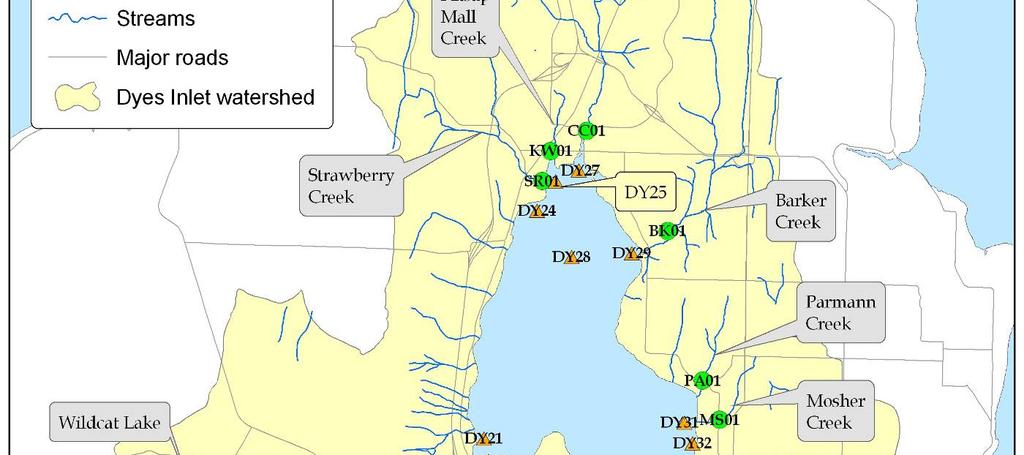
9 MARINE WATER MONITORING DATA SUMMARY The map below shows the location of marine monitoring stations in Dyes Inlet. The stations with statistically significant improving long term trends included: DY07, DY20, DY24, DY25, DY27, DY28, DY29, DY31 and DY34. The remaining stations, DY05, DY14, DY15, DY33, DY37 had stationary trends. 9
10 MARINE WATER QUALITY STANDARDS Fourteen of the fifteen monitoring stations met water quality standards during the monitoring year. In addition, twelve of these exceeded the state marine water standard for temperature. These typically occurred during the summer months. OVERALL MARINE WATER QUALITY TREND Dyes Inlet Marine Water Summary Max 75% Median 25% Min Most Recent 12- Dyes Inlet marine waters as a whole show a stationary global trend because the trends are not equal at stations. Nine of the fourteen individual sampling stations (DY07, DY20, DY24, DY25, DY27, DY28, DY29, DY31, DY34) show a significantly improving long-term trend. 10
Dyes Inlet DYES INLET WATERSHED Water Quality Monitoring Report Kitsap Public Health District
 DYES INLET WATERSHED 2014 Water Quality Monitoring Report Kitsap Public Health District 1 2 DYES INLET WATERSHED The Dyes Inlet watershed, designated as Primary Contact waters by the State, is located
SINCLAIR INLET WATERSHED
 SINCLAIR INLET WATERSHED 2015 Water Quality Monitoring Report Kitsap Public Health District SN18 2015 STREAM WATER QUALITY SUMMARY The Sinclair Inlet watershed is located in central Kitsap County. Most
COLVOS PASSAGE YUKON HARBOR WATERSHED
 COLVOS PASSAGE YUKON HARBOR WATERSHED 2014 Water Quality Monitoring Report Kitsap Public Health District 1 2 COLVOS PASSAGE / YUKON HARBOR WATERSHED The Colvos Passage / Yukon Harbor (CP/YH) watershed,
KITSAP COUNTY HEALTH DISTRICT ENVIRONMENTAL HEALTH DIVISION POLLUTION IDENTIFICATION & CORRECTION PROGRAM DYES INLET RESTORATION PROJECT FINAL REPORT
 KITSAP COUNTY HEALTH DISTRICT ENVIRONMENTAL HEALTH DIVISION POLLUTION IDENTIFICATION & CORRECTION PROGRAM DYES INLET RESTORATION PROJECT FINAL REPORT By: Richard Bazzell December 2009 Funded By: TABLE
UPPER HOOD CANAL WATERSHED
 UPPER HOOD CANAL WATERSHED 2014 Water Quality Monitoring Report Kitsap Public Health District 1 2 UPPER HOOD CANAL WATERSHED The Upper Hood Canal (UHC) watershed, most of which is designated as Extraordinary
LIBERTY BAY / MILLER BAY WATERSHED
 LIBERTY BAY / MILLER BAY WATERSHED 2014 Water Quality Monitoring Report Kitsap Public Health District 1 2 LIBERTY BAY / MILLER BAY WATERSHED The Liberty Bay / Miller Bay (LB/MB) watershed, designated as
UPPER HOOD CANAL WATERSHED
 UPPER HOOD CANAL WATERSHED 2017 Water Quality Monitoring Report Kitsap Public Health District 11-1 11-2 Upper Hood Canal 2017 2017 WATER QUALITY SUMMARY The Upper Hood Canal (UHC) watershed, most of which
Environment Water Quality Monitoring report th Street Suite 300 Bremerton, WA (fax)
") Environment 2013 Water Quality Monitoring report KITSAP PUBLIC HEALTH DISTRICT 345 6th Street Suite 300 Bremerton, WA 98337 360-337-5235 360-337-5291 (fax) December 31, 2013 Fundeded Through: KITSAP PUBLIC
Environment 2013 Water Quality Monitoring report KITSAP PUBLIC HEALTH DISTRICT 345 6th Street Suite 300 Bremerton, WA 98337 360-337-5235 360-337-5291 (fax) December 31, 2013 Fundeded Through: KITSAP PUBLIC
Henderson Watershed WRIA 13. Chapter Includes: Tanglewilde Stormwater Outfall Woodard Creek Woodland Creek
 Henderson Watershed WRIA 13 Chapter Includes: Tanglewilde Stormwater Outfall Woodard Creek Woodland Creek 146 Tanglewilde Stormwater Outfall PART OF HENDERSON WATERSHED PRIMARY LAND USES: Urban residential
Water Quality WRIA 15. Danielle DeVoe WA Dept. of Ecology Water Quality Specialist January, 2016
 Water Quality WRIA 15 Danielle DeVoe WA Dept. of Ecology Water Quality Specialist January, 2016 WAC 173-201A: Washington Water Quality Standards and the State Water Quality Assessment Purpose: establish
Jean Snyder, Public Health Advisor Office of Environmental Health and Safety Washington State Department of Health November 1, 2016
 Jean Snyder, Public Health Advisor Office of Environmental Health and Safety Washington State Department of Health November 1, 2016 Public Health Always Working for a Safer and Healthier Washington 105
Kitsap County Health District Water Quality Program Enetai Creek Pollution Identification and Correction Project December 15, 2009
 Summary Kitsap County Health District Water Quality Program Enetai Creek Pollution Identification and Correction Project December 15, 2009 Enetai Creek, formerly known as Dee Creek, is polluted with fecal
KITSAP PUBLIC HEALTH DISTRICT ENVIRONMENTAL HEALTH DIVISION POLLUTION IDENTIFICATION & CORRECTION PROGRAM
 KITSAP PUBLIC HEALTH DISTRICT ENVIRONMENTAL HEALTH DIVISION POLLUTION IDENTIFICATION & CORRECTION PROGRAM PORT ORCHARD PASSAGE RESTORATION PROJECT FINAL REPORT Lucas Jordan Stuart Whitford June 2013 Funding
HORSESHOE LAKE WATER QUALITY IMPROVEMENT PROJECT FINAL REPORT
 KITSAP COUNTY HEALTH DISTRICT ENVIRONMENTAL HEALTH DIVISION POLLUTION IDENTIFICATION AND CORRECTION PROGRAM HORSESHOE LAKE WATER QUALITY IMPROVEMENT PROJECT FINAL REPORT By Kimberly Jones Environmental
BURLEY WATERSHED PREVENTION/RESTORATION PROJECT FINAL REPORT
 BURLEY WATERSHED PREVENTION/RESTORATION PROJECT FINAL REPORT 1.0 INTRODUCTION Burley Lagoon is an abundant shellfish harvest area that has been utilized as a commercial growing area since the 1930 s. According
Thurston County Surface Water Quality & Sensitive Areas
 Thurston County Surface Water Quality & Sensitive Areas Purpose of this Presentation: To provide an overview of the County s surface water quality conditions as it relates to septic systems Many County
UPPER HOOD CANAL RESTORATION PROJECT FINAL REPORT
 1.0 INTRODUCTION UPPER HOOD CANAL RESTORATION PROJECT FINAL REPORT Washington State Department of Ecology monitoring stations in Hood Canal show that hypoxic conditions may persist year-round in the southern
PORT GAMBLE BAY/GAMBLEWOOD SANITARY SURVEY PROJECT FINAL REPORT
 PORT GAMBLE BAY/GAMBLEWOOD SANITARY SURVEY PROJECT FINAL REPORT 1.0 INTRODUCTION The Bremerton- s Sanitary Survey Program s 1995-96 Priority Area Work List rated the Port Gamble Bay/Gamblewood area most
Section F: Evaluating Beneficial Use: Recreation Ohio Integrated Report
 Section F: Evaluating Beneficial Use: Recreation 2008 Ohio Integrated Report F1. Background Prior to the 2002 IR, the reporting of recreational use impairment in Ohio was sporadic. Section 305(b) reports
Kitsap County Health District Upper Hood Canal Pollution Identification and Correction Project Final Report
 Final Report Leslie Banigan, R.S. Pollution Identification and Correction Program December 31, 2008 Funded by Washington State Department of Ecology, Centennial Clean Water Funds and the Kitsap County
Burley Lagoon and Minter Bay Water Quality Protection Team Thursday October 26, :30 11 a.m.
 Burley Lagoon and Minter Bay Water Quality Protection Team Thursday October 26, 2017 9:30 11 a.m. Peninsula Light Building 13315 Goodnough Dr. NW Gig Harbor (Purdy), WA Washington State Department of Ecology
Burley Lagoon Water Quality Team Notes
 Burley Lagoon Water Quality Team Notes 4-28-2016 Meeting, Key Pen Light Building, 1st Floor meeting room. 9:30 a.m. Forming the Burley Lagoon: The geology and hydrology of Purdy Spit Burley lagoon is situated
Totten Watershed WRIA 13. Chapter Includes: Kennedy Creek. Schneider Creek (Totten)
") Totten Watershed WRIA 13 Chapter Includes: Kennedy Creek Schneider Creek (Totten) 257 Kennedy Creek #0012 PART OF TOTTEN/LITTLE SKOOKUM WATERSHED LENGTH OF CREEK: 10 miles BASIN SIZE: 19 square miles STREAM
Totten Watershed WRIA 13 Chapter Includes: Kennedy Creek Schneider Creek (Totten) 257 Kennedy Creek #0012 PART OF TOTTEN/LITTLE SKOOKUM WATERSHED LENGTH OF CREEK: 10 miles BASIN SIZE: 19 square miles STREAM
KITSAP PUBLIC HEALTH DISTRICT ENVIRONMENTAL HEALTH DIVISION WATER POLLUTION IDENTIFICATION & CORRECTION PROGRAM
 KITSAP PUBLIC HEALTH DISTRICT ENVIRONMENTAL HEALTH DIVISION WATER POLLUTION IDENTIFICATION & CORRECTION PROGRAM SINCLAIR INLET RESTORATION PROJECT FINAL REPORT Leslie Banigan Stuart Whitford November 2013
Susan Walther Environmental Health Specialist
 Nutrient Reduction PIC: Murden Cove/Fletcher Bay National Estuary Program (NEP): Toxics and Nutrients Prevention, Reduction and Control Grant #G1387 1/1/213 12/31/215 Susan Walther Environmental Health
Onsite Sewage System Operation & Maintenance in Thurston County
 Onsite Sewage System Operation & Maintenance in Thurston County O&M History 1984 -O&M permits around Lakes GSA; 1990 -O&M permits expanded to new, repairs, and when sold; 1995 -WAC 246-272 requires O&M;
OKLAHOMA DEPARTMENT OF ENVIRONMENTAL QUALITY PUBLIC NOTICE. June 24, 2010 AVAILABILITY OF DRAFT BACTERIA TMDL FOR THE BIRD CREEK AREA WATERSHED
 Steve Thompson Executive Director OKLAHOMA DEPARTMENT OF ENVIRONMENTAL QUALITY Brad Henry Governor PUBLIC NOTICE June 24, 2010 AVAILABILITY OF DRAFT BACTERIA TMDL FOR THE BIRD CREEK AREA WATERSHED REQUEST
SHORELINE MONITORING PLAN
 SHORELINE MONITORING PLAN Water Pollution Identification & Correction Program Shoreline Monitoring Plan Page 1 of 26 TABLE OF CONTENTS Section Page Number 1. Introduction... 2 2. Monitoring Goals and Objectives...
KITSAP COUNTY HEALTH DISTRICT ENVIRONMENTAL HEALTH DIVISION WATER QUALITY PROGRAM YUKON HARBOR WATERSHED RESTORATION PROJECT FINAL REPORT
 KITSAP COUNTY HEALTH DISTRICT ENVIRONMENTAL HEALTH DIVISION WATER QUALITY PROGRAM YUKON HARBOR WATERSHED RESTORATION PROJECT FINAL REPORT By: Michael Drew and Leslie Banigan December 2006 Funded By: Washington
Septic System Operation and Maintenance Proposal For Nisqually Reach Watershed
 Septic System Operation and Maintenance Proposal For Nisqually Reach Watershed Draft Proposal January 25, 2011 Open House The Nisqually Reach Risk-Based O&M Program project advisory committee began its
Goose Creek Watershed Assessment Summary October 2003
 Goose Creek Watershed Assessment Summary October 2003 The Goose Creek Watershed The Goose Creek watershed is 385 square miles, covering nearly half of Loudoun County and one-quarter of Fauquier County
 1 2 3 4 5 6 7 8 9 10 11 12 13 14 15 16 Trend Monitoring - Stream 17 1600 Fecal Coliform Bacteria MPN per 100 ml 1400 1200 1000 800 600 400 200 0 200 - P Part 2 15-Jun-94 28-Oct-95 11-Mar-97 24-Jul-98 6-Dec-99
KITSAP COUNTY LOCAL MANAGEMENT PLAN FOR ONSITE SEWAGE TABLE OF CONTENTS
 KITSAP COUNTY LOCAL MANAGEMENT PLAN FOR ONSITE SEWAGE TABLE OF CONTENTS PART 1 DATABASE ENHANCEMENT... 8 A. Inventory...8 I. Current Onsite Sewage System (OSS) Databases... 8 II. Adding and Updating Records
Water Quality Regulatory Programs and Our Citywide EPA / DEQ Stormwater Permit. Public Works Engineering City Council Briefing June 7, 2016
 Water Quality Regulatory s and Our Citywide EPA / DEQ Stormwater Permit Public Works Engineering City Council Briefing June 7, 2016 Briefing Topics Introduction: Regulatory Overview Elements of the MS4
CLALLAM PIC UPDATE. PIC Open House
 CLALLAM PIC UPDATE PIC Open House Thanks to everybody for coming out to the Pollution Identification and Correction open house at MacCleay Hall (Sequim Prairie Grange) last month. Participants had lots
Fecal Coliform Model Verification Sampling Plan Winter Fecal Coliform Total Maximum Daily Load Study Plan For Sinclair and Dyes Inlets
 Fecal Coliform Model Verification Sampling Plan Winter 2004 Addendum to the Fecal Coliform Total Maximum Daily Load Study Plan For Sinclair and Dyes Inlets R.K. Johnston, Ph.D. Marine Environmental Support
LaHave River Watershed Project 2015 Field Report
 LaHave River Watershed Project 2015 Field Report Prepared by S. Fredericks Bluenose Coastal Action Foundation 37 Tannery Road Lunenburg, N.S. B0J 2C0 April 2016 LaHave River Watershed Project 2015 Project
NEWPORT BAY FECAL COLIFORM TMDL
 NEWPORT BAY FECAL COLIFORM TMDL 2016 ANNUAL DATA REPORT SEPTEMBER 1, 2016 Prepared for: Santa Ana Regional Water Quality Control Board to fulfill requirements of the TMDL for Fecal Coliform in Newport
Shellfish Sanitation and Recreational Water Quality Section. N.C. Division of Marine Fisheries Dept. of Environment and Natural Resources
 Shellfish Sanitation and Recreational Water Quality Section N.C. Division of Marine Fisheries Dept. of Environment and Natural Resources Shellfish Sanitation Program Started in 1925 following outbreaks
Surface Water Improvement and Management (SWIM) Plan Development
 Plan Development") Surface Water Improvement and Management (SWIM) Plan Development Bay Area Resource Council TAC Paul Thorpe Chief, Bureau of Environmental May 17, 2017 and Resource Planning May 17, 2017 Surface Water Improvement
Surface Water Improvement and Management (SWIM) Plan Development Bay Area Resource Council TAC Paul Thorpe Chief, Bureau of Environmental May 17, 2017 and Resource Planning May 17, 2017 Surface Water Improvement
TMDL Report for Chesapeake Bay Shellfish Waters: Ware Creek, Taskinas Creek, and Skimino Creek Bacterial Impairments (VADEQ, 2010)
") As part of a long term commitment to environmental stewardship, James City County volunteers and staff have been gathering information about stream health throughout the County since 2008. The goal of
As part of a long term commitment to environmental stewardship, James City County volunteers and staff have been gathering information about stream health throughout the County since 2008. The goal of
Pamela Reitsma Environmental Scientist Narragansett Bay Commission
 Pamela Reitsma Environmental Scientist Narragansett Bay Commission Narragansett Bay Commission Narragansett Bay Commission (NBC) is a quasi-state agency which oversees the two largest WWTFs in Rhode Island:
KITSAP PUBLIC HEALTH DISTRICT ENVIRONMENTAL HEALTH DIVISION WATER POLLUTION IDENTIFICATION & CORRECTION PROGRAM
 KITSAP PUBLIC HEALTH DISTRICT ENVIRONMENTAL HEALTH DIVISION WATER POLLUTION IDENTIFICATION & CORRECTION PROGRAM LIBERTY BAY WATERSHED RESTORATION PROJECT FINAL REPORT Eva Crim Kimberly Jones Newton Morgan
TORCH LAKE TOWNSHIP WATER QUALITY ACTION PLAN
 TORCH LAKE TOWNSHIP WATER QUALITY ACTION PLAN Elk-River-Chain-of-Lakes Gaps Analysis Project The Watershed Center Grand Traverse Bay Tip of the Mitt Watershed Council Michigan Department of Natural Resources
Morro Bay National Estuary Program s Implementation Effectiveness Program For the Morro Bay Watershed. Stormwater Monitoring Report 2015
 Morro Bay National Estuary Program s Implementation Effectiveness Program For the Morro Bay Watershed Stormwater Monitoring Report 215 Loan Agreement Number 12-81-55 Task 3.4 Submitted by Morro Bay National
2014 Whatcom County Stormwater Management Program
 2014 2014 Whatcom County Stormwater Management Program A component of the Western Washington Phase II Municipal Stormwater Permit Whatcom County Public Works Department Stormwater Division THIS PAGE INTENTIONALLY
NEWPORT BAY FECAL COLIFORM TMDL
 NEWPORT BAY FECAL COLIFORM TMDL 2017 ANNUAL DATA REPORT SEPTEMBER 1, 2017 Prepared for: Santa Ana Regional Water Quality Control Board to fulfill requirements of the TMDL for Fecal Coliform in Newport
Section V.H. Fresh Water Resources
 Section V.H. Fresh Water Resources Section V.H. Fresh Water Resources 205 I. Fresh Water Resources Though previous comprehensive plans indicate several dozen minor watersheds in Islesboro, each draining
Grand Traverse Bay Watershed Protection Plan:
 Grand Traverse Bay Watershed Protection Plan: An Overview Sarah U Ren Program Director The Watershed Center 231-935-1514, suren@gtbay.org What is a Watershed? A watershed is an area of land that captures
Te Puna Environmental Monitoring Results (Update January 2015)
") Te Puna Environmental Monitoring Results (Update January ) Introduction Many of the Bay of Plenty s coastal communities are served by on-site wastewater treatment systems. In areas of more concentrated
Te Puna Environmental Monitoring Results (Update January ) Introduction Many of the Bay of Plenty s coastal communities are served by on-site wastewater treatment systems. In areas of more concentrated
CHAPTER 10 CRITICAL DRAINAGE AREAS
 CHAPTER 10 CRITICAL DRAINAGE AREAS Contents 10.0 INTRODUCTION 10-1 10.1 IDENTIFICATION OF CRITICAL DRAINAGE AREAS 10-1 10.1.1 Site Physical Attributes 10-2 10.1.2 Protection of Fish & Wildlife Habitat
Vancouver Watershed Health Assessment. Burnt Bridge Creek Watershed
 Vancouver Watershed Health Assessment Burnt Bridge Creek Watershed Presentation Overview 1. Introduction 2. Study Context 3. Burnt Bridge Creek Monitoring Program and Trend Analysis 4. Watershed Health
Flow-Based Surrogate TMDLs, A Case Study in Ohio
 Lower Grand River TMDL January 2012 This fact sheet describes the characteristics of a good surrogate total maximum daily load (TMDL) and the factors that should be considered when selecting a surrogate
Water Quality and Flow Monitoring Program Benefits
 Benefit Policy review, initiation, and implementation Comprehensive Plan Shoreline Master Program Plan Strategic Planning & Resource Allocation Capital Improvement Plan Community Initiatives Utility Plan
OKLAHOMA DEPARTMENT OF ENVIRONMENTAL QUALITY PUBLIC NOTICE. January 24, 2008 AVAILABILITY OF DRAFT BACTERIA TMDL FOR THE NEOSHO RIVER BASIN
 Steve Thompson Executive Director OKLAHOMA DEPARTMENT OF ENVIRONMENTAL QUALITY Brad Henry Governor PUBLIC NOTICE January 24, 2008 AVAILABILITY OF DRAFT BACTERIA TMDL FOR THE NEOSHO RIVER BASIN REQUEST
BIG ROCHE A CRI LAKE CHARACTERISTICS
 BIG ROCHE A CRI LAKE CHARACTERISTICS Lake Description Big Roche Cri Lake is located in north central Adams County and has a surface area of 205 acres, a shoreline length of 6.1 mile, a volume of 6,993
Swim At Your Own Risk! E.coli Impaired Recreational Waters in Salt Lake County: Jordan, Parley's and Emigration
 ! E.coli Impaired Recreational Waters in Salt Lake County: Jordan, Parley's and Emigration Presenters: - Leah Ann Lamb, Utah Division of Water Quality - Bob Thompson, Salt Lake County - Teresa Gray, Salt
CENTRAL KITSAP COUNTY WASTEWATER FACILITY PLAN ADDENDUM
 CENTRAL KITSAP COUNTY WASTEWATER FACILITY PLAN ADDENDUM Prepared for Kitsap County Department of Public works May 2013 Prepared by: TABLE OF CONTENTS CHAPTER 1: INTRODUCTION 1.1 Purpose of Addendum...
August 19, Subject: IBT Report for Dear Ms. Nimmer:
 August 19, 2016 Ms. Kim Nimmer Water Supply Planning Branch N.C. Division of Water Resources 1611 Mail Service Center Raleigh, North Carolina 27699-1611 Subject: IBT Report for 2015 Dear Ms. Nimmer: We
NATIONAL FISH AND WILDLIFE FOUNDATION (NFWF) PHASE II
 PHASE II") This suite of projects will reduce sediment and nutrient loading to Bayou Chico, reduce turbidity, increase water clarity, and improve light penetration for photosynthesis to enable expansion of submerged
This suite of projects will reduce sediment and nutrient loading to Bayou Chico, reduce turbidity, increase water clarity, and improve light penetration for photosynthesis to enable expansion of submerged
Restoring a National Treasure: Chesapeake Bay. Presented by Dan Nees, Director Environmental Finance Center University of Maryland April 27, 2007
 Restoring a National Treasure: Chesapeake Bay Presented by Dan Nees, Director Environmental Finance Center University of Maryland April 27, 2007 Agenda Introduction to the Chesapeake Bay Restoration challenges
Thurston County On Site Sewage Management Plan 2014 Update
 Thurston County On Site Sewage Management Plan 2014 Update Public Health and Social Services Department Environmental Health Division Final Draft July 2014 Prepared by BH Consulting, LLC THIS PROJECT HAS
Lakes & Swimming Beaches LAKES & SWIMMING BEACHES
 LAKES & SWIMMING BEACHES 1 LAKES & SWIMMING BEACHES: MONITORING PROGRAM BACKGROUND In 2014, the Kitsap Public Health District collected water samples at 23 swimming beaches or other public access areas
Draft Bacteria Total Maximum Daily Load Action Plan
 Draft Bacteria Total Maximum Daily Load Action Plan Public Works Department VSMP MS4 Permit # VA0088676 DRAFT June 12, 2018 Draft Bacteria Total Maximum Daily Load Action Plan (Permit VA0088676) Table
Chesapeake Bay Foundation 101. Robert Jennings
 Chesapeake Bay Foundation 101 Robert Jennings About the Bay Chesapeake Bay Watershed 64,000 square miles 19 major rivers 400 smaller creeks 3,000 species of plants and animals 17 million people How s the
Grand Traverse Bay Watershed Protection Plan:
 Grand Traverse Bay Watershed Protection Plan: An Overview Sarah U Ren Program Director The Watershed Center 231-935-1514, suren@gtbay.org The Grand Traverse Bay Watershed 973 square miles Bay Volume =
City of Toronto s Climate Change Adaptation Strategy to Address Urban Flooding
 City of Toronto s Climate Change Adaptation Strategy to Address Urban Flooding Michael D Andrea, M.E.Sc., P.Eng. Chief Engineer and Executive Director Engineering & Construction Services City of Toronto
SCOPE OF WORK (Last amendment 9/18/08) Update: Signed agreement in hand Work to proceed March 15, 2009 June 30, 2010
 Update: Signed agreement in hand Work to proceed March 15, 2009 June 30, 2010") SCOPE OF WORK (Last amendment 9/18/08) Update: Signed agreement in hand Work to proceed March 15, 2009 June 30, 2010 TITLE: IDENTIFICATION OF ILLICIT DISCHARGES TO STORM DRAIN SYSTEM PROBLEM/NEED: The
SCOPE OF WORK (Last amendment 9/18/08) Update: Signed agreement in hand Work to proceed March 15, 2009 June 30, 2010 TITLE: IDENTIFICATION OF ILLICIT DISCHARGES TO STORM DRAIN SYSTEM PROBLEM/NEED: The
The Snapshot CONODOGUINET CREEK WATERSHED SNAPSHOT
 CONODOGUINET CREEK WATERSHED SNAPSHOT ABOVE: CONODOGUINET CREEK AT RT 74 BRIDGE FACING DOWNSTREAM The Snapshot The Conodoguinet Watershed Snapshot was a collaborative effort to engage local citizens in
City of Fairmont Storm Water Pollution Prevention Plan Annual Public Meeting. June 11, 2018
 City of Fairmont Storm Water Pollution Prevention Plan Annual Public Meeting June 11, 2018 Why is Water Quality Important? Water has always been important to Minnesota and is a key part of our history,
6. Pollutant Sources in
 6. Pollutant Sources in 45 6. Pollutant Sources in the Plum Creek Watershed The LDC analysis for Plum Creek indicates that both point and nonpoint sources contribute pollutants in the watershed. Identifying
MILTON TOWNSHIP WATER QUALITY ACTION PLAN
 MILTON TOWNSHIP WATER QUALITY ACTION PLAN Elk-River-Chain-of-Lakes Gaps Analysis Project The Watershed Center Grand Traverse Bay Tip of the Mitt Watershed Council Michigan Department of Natural Resources
Program Component Considerations
 Illicit Discharge Detection and Elimination: Program Component Considerations Presented At: A Workshop for Stormwater Program Managers Kansas City, KS July 20-21, 2004 Presented By: Presentation Overview
TOTAL MAXIMUM DAILY LOAD (TMDL)
") TOTAL MAXIMUM DAILY LOAD (TMDL) For Nutrients In Black Point Channel (WBID 1637) Prepared by: US EPA Region 4 61 Forsyth Street SW Atlanta, Georgia 30303 September 2009 TABLE OF CONTENTS 1.0 INTRODUCTION...
TOTAL MAXIMUM DAILY LOAD (TMDL) For Nutrients In Black Point Channel (WBID 1637) Prepared by: US EPA Region 4 61 Forsyth Street SW Atlanta, Georgia 30303 September 2009 TABLE OF CONTENTS 1.0 INTRODUCTION...
2016 Summit Lake Water Quality Report Prepared by Thurston County Environmental Health Division
 ! 216 Summit Lake Water Quality Report Prepared by Thurston County Environmental Health Division PART OF TOTTEN INLET WATERSHED LENGTH OF LAKE: 2.2 miles SHORELINE LENGTH: 5.6 miles LAKE SIZE: 53 acres
CITY OF BREMERTON DEPARTMENT OF PUBLIC WORKS AND UTILITIES COMBINED SEWER OVERFLOW ANNUAL REPORT FOR 2014
 CITY OF BREMERTON DEPARTMENT OF PUBLIC WORKS AND UTILITIES COMBINED SEWER OVERFLOW ANNUAL REPORT FOR 2014 NPDES PERMIT #WA-002928-9 SUBMITTED TO WASHINGTON DEPARTMENT OF ECOLOGY May 30, 2015 TABLE OF CONTENTS
6.5 The Present Situation Water Quality Stormwater quality is currently being improved by:
 6.5 The Present Situation 6.5.1 Water Quality Stormwater quality is currently being improved by: o o o o The SPE project. The project is driven by the 11 resource consents for the discharge of wastewater-contaminated
Hempstead Harbor F Protection Committee
 Hempstead Harbor F Protection Committee An Inter-municipal Watershed Protection Committee of the County of Nassau, the Towns of North Hempstead and Oyster Bay, the City of Glen Cove, and the Villages of
Removing and Preventing Non-Stormwater Discharges in Kitsap:
 Removing and Preventing Non-Stormwater Discharges in Kitsap: Integrating Program Components Mindy Fohn, Water Quality Manager Agenda Program Drivers Programs to Identify and Remove Outfall Screening Spill
City of Toronto s Climate Change Adaptation Strategy to Mitigate Urban Flooding
 City of Toronto s Climate Change Adaptation Strategy to Mitigate Urban Flooding Michael D Andrea, M.E.Sc., P.Eng. Chief Engineer and Executive Director, Engineering & Construction Services City of Toronto
State of Florida Department of Community Affairs Areas of Critical State Concern Implementation Status Report Apalachicola Bay Area
 State of Florida Department of Community Affairs Areas of Critical State Concern Implementation Status Report Apalachicola Bay Area Thaddeus L. Cohen, AIA Secretary November 2006 CONTENTS Part 1 - Summary
Building a Phase III WIP for Wastewater, Stormwater & Septic Systems
 Building a Phase III WIP for Wastewater, Stormwater & Septic Systems Agriculture Leadership Roundtable Double Tree by Hilton, Annapolis July 25, 2018 Greg Busch gregory.busch@maryland.gov Presentation
Watershed master planning, City of Griffin, Georgia, USA
 Water Resources Management VII 3 Watershed master planning, City of Griffin, Georgia, USA J. K. Kaplan & B. J. Watson Tetra Tech, Water Resources Group, Atlanta, Georgia, USA Abstract Tetra Tech has assisted
Tracking sources of E.coli with DNA markers, Canine Scenting, and Forecast Models.
 MICHIGAN DEPARTMENT OF ENVIRONMENTAL QUALITY Tracking Sources of E. coli Tracking sources of E.coli with DNA markers, Canine Scenting, and Forecast Models. Dr. Amira Oun, OunA@michigan.gov Ms. Alex Strohm,
LAKES & SWIMMING BEACHES
 Lakes & Swimming Beaches 2015 LAKES & SWIMMING BEACHES 2015 Water Quality Monitoring Report Kitsap Public Health District 1 LAKES & SWIMMING BEACHES: MONITORING PROGRAM BACKGROUND In 2015, the Kitsap Public
Monday, January 9th, :00 pm. Montgomery Park, Lobby Conference Rooms
 Monday, January 9th, 2016 6:00 pm Montgomery Park, Lobby Conference Rooms Purpose of This Meeting Provide General Information/Updates on 2016 IR and MD s TMDL Prioritization Encourage public dialogue,
Climate Impacts and Action
 Climate Impacts and Action Green/Duwamish Watershed Advisory Group January 21 st, 2016 Matt Kuharic Senior Climate Change Specialist DNRP Director s Office www.kingcounty.gov/climate 1 Climate Impacts
MIDDLE GRAND RIVER WATERSHED MANAGEMENT PLAN
 MIDDLE GRAND RIVER WATERSHED MANAGEMENT PLAN Michigan Department of Environmental Quality tracking code: #2010-0012 Prepared by: Rachael Loucks Watershed Coordinator Eaton Conservation District 551 Courthouse
ELK RAPIDS TOWNSHIP WATER QUALITY ACTION PLAN
 ELK RAPIDS TOWNSHIP WATER QUALITY ACTION PLAN Elk-River-Chain-of-Lakes Gaps Analysis Project The Watershed Center Grand Traverse Bay Tip of the Mitt Watershed Council Michigan Department of Natural Resources
Cannon River One Watershed, One Plan. POLICY COMMITTEE MEETING January 10, 2018 Rice County Government Center Faribault, MN
 Cannon River One, One Plan POLICY COMMITTEE MEETING January 10, 2018 Rice County Government Center Faribault, MN TASK Task 1. Aggregate Existing Physical & Spatial Data 1A. Create project maps 1B. Meeting
Hood Canal Watershed Clean Water Project
 Hood Canal Watershed Clean Water Project Ecology grant number G1100189 Figure 1. Mouth of the Duckabush River. Photo from Ecology Eyes Over Puget Sound, July 2014. December 31, 2014 Michael Dawson, Ashley
TOTAL MAXIMUM DAILY LOAD ANALYSIS FOR GREENWICH BAY WATERS PATHOGEN / BACTERIA IMPAIRMENTS
 TOTAL MAXIMUM DAILY LOAD ANALYSIS FOR GREENWICH BAY WATERS PATHOGEN / BACTERIA IMPAIRMENTS GREENWICH BAY APPONAUG COVE BRUSH NECK COVE BUTTONWOODS COVE GREENWICH COVE WARWICK COVE BAKER CREEK DARK ENTRY
Surface Water Improvement and Management (SWIM) Plan Development
 Plan Development") Surface Water Improvement and Management (SWIM) Plan Development Bay Area Resource Council TAC Paul Thorpe Chief, Bureau of Environmental May 17, 2017 and Resource Planning May 17, 2017 Surface Water Improvement
Surface Water Improvement and Management (SWIM) Plan Development Bay Area Resource Council TAC Paul Thorpe Chief, Bureau of Environmental May 17, 2017 and Resource Planning May 17, 2017 Surface Water Improvement
EPA s NPDES Stormwater Permitting Program
 EPA s NPDES Stormwater Permitting Program C O N N I E B O S M A C H I E F, M U N I C I PA L B R A N C H U. S. E N V I R O N M E N TA L P R OT E C T I O N A G E N C Y / WAT E R P E R M I T S D I V I S I
Wastewater Systems. Dave Lenning Washington Dept. of Health
 Wastewater Systems Dave Lenning Washington Dept. of Health Our Focus: Wastewater issues & options for small communities Decentralized and centralized Relationship to land use planning Wastewater in Washington
Factsheet: Town of Deep River Water Quality and Stormwater Summary
 79 Elm Street Hartford, CT 06106-5127 www.ct.gov/deep Affirmative Action/Equal Opportunity Employer Factsheet: Town of Deep River Water Quality and Stormwater Summary This document was created for each
Ocean Water Quality Challenges
 Ocean Water Quality Challenges Dominic Gregorio Senior Environmental Scientist, Ocean Unit Division of Water Quality State Water Resources Control Board www.waterboards.ca.gov NPDES Permits written to
Tioga County Conservation District Watershed Program
 Tioga County Conservation District Watershed Program What is a watershed? A watershed is the land area that drains into a stream, river, or body of water. In Tioga County, there are seven major watersheds,
WOLF CREEK BACTERIAL IMPACT ON MAUMEE BAY STATE PARK BEACH
 WOLF CREEK BACTERIAL IMPACT ON MAUMEE BAY STATE PARK BEACH SUMMARY REPORT JUNE 2003 WOLF CREEK BACTERIAL IMPACT ON MAUMEE BAY STATE PARK BEACH SUMMARY REPORT JUNE 2003 Conducted by University of Toledo
Proposed Wastewater Nitrogen Management Bylaw for Wareham, MA
 Proposed Wastewater Nitrogen Management Bylaw for Wareham, MA Presentation to Town Meeting Dr. Joe Costa Buzzards Bay National Estuary Program April 30, 2007 Wareham s Watersheds The Problem with Nitrogen