Tompkins County Wastewater Treatment Public Sewer Service Areas and Septic Site Suitability Analysis
|
|
|
- Arline Cameron
- 5 years ago
- Views:
Transcription
1 Tompkins County Wastewater Treatment Public Sewer Service Areas and Septic Site Suitability Analysis Ruth Kroeger CRP 5080 Professor Stephan Schmidt Spring 2009
2 Acknowledgements I would like to thank Ruth Aslanis at the GIS Division of the City of Ithaca for providing the initial impetus for this report, supplying much of my data, and providing guidance and feedback. I am also appreciative of the assistance of Professor Stephan Schmidt and the support of my classmates throughout the process. 2
3 Table of Contents Page I. Introduction 4 Background 4 Context 4 Objectives 7 II. Data and Methodology 8 III. Analysis 13 IV. Discussion and Conclusions 16 V. References 17 VI. Appendix (Maps) 19 3
4 I. Introduction Background This project began in cooperation with the GIS Division of the City of Ithaca. The City asked me to create a series of maps depicting their wastewater treatment systems. Following my discussions with the City, I decided to expand my analyses to include research wastewater treatment throughout Tompkins Count and to focus particularly on the debate over the proposed Lansing sewage system. Context Tompkins County covers 468 square kilometers and contains 18 census tracts. 1 According to the 2000 Census, the county has a population of over 80,000 people. 2 Approximately 99% of the 21 thousand buildings in the region are associated with residential housing. 3 The Town of Lansing is located in the center of the northern half of Tompkins County, along the eastern shore of Cayuga Lake. It is one of the fastest growing towns in the county, second only to Dryden in the number of new homes built between 2001 and Two wastewater treatment plants currently service the towns around the urbanized center of the County. The Ithaca Area Waste Water Treatment Plant and the Cayuga Heights Wastewater Treatment Plant both release treated wastewater into Lake Cayuga. While the Cayuga Heights plant is near capacity, an intermunicipal agreement allows Cayuga Heights to divert some of its flow to the Ithaca plant and the two towns work together closely to monitor the entire system. 5 Archival research of The Ithaca Journal indicate that discussions about sewer system in Lansing began as early as the mid-1990s as a way to keep development to the south of the town. 6 Proponents of the system argue it will help control development and preserve the rural northern 1 Tompkins County, Ibid. 3 Ibid. 4 Ashmore, Daley, Ibid. 4
5 part of Lansing while preventing groundwater pollution. 7 A journalist in the Ithaca Journal writes: Because of geological conditions such as thin soil and high bedrock, septic tanks in much of the town have to be widely spaced, which has led to relatively large lots and spread-out, often costly development. A sewer system was seen by some in Lansing as a way to stimulate creation of a town center in the southern portion of Lansing. Also, failing or poor-performing septic tanks can threaten groundwater, including larger creeks and even Cayuga Lake. 8 In a 2005 Ithaca Journal article, Lansing s town supervisor, Steve Farkas, stated the town was seeking to build a system of mains that would connect to the Cayuga Heights Wastewater Treatment Plant. Farkas was concerned about failing, aged or poorly maintained [septic] systems, as well as the amount of land required to maintain a septic system. 9 With a public sewer system, houses could be built on lots of as small as a quarter-acre, instead of the one or two acre lots needed for septic systems, which would serve to protect farmland in the north of Lansing. Farkas also stated that a sewage system would encourage economic development and bring more people and business into the town. In a 2007 Journal article, the director of the county s environmental health services, John Anderson, stressed the particular need for sewer in the southern part of the town where the soil is especially impermeable, making it difficult for septic systems to function effectively. 10 The 2005 article also addresses environmental concerns associated with increased levels of phosphorous that could potentially be added to the southern portion of Cayuga Lake if more wastewater was released from the treatment plants. While a new phosphorous removal system in the Ithaca Area Waste Water Treatment Plant would mitigate the impact of increased flow, the Cayuga Heights Plant, where the majority of Lansing s effluent would go, has no plans for an upgraded phosphorous removal system. 7 Hill, Ibid. 9 Daley, King,
6 A second article dated October 20, 2006 indicates that by 2014, there would be a demand for 3,000 to 4,000 additional dwelling units in the region, which the sewage systems proponents argue will help pay for the estimated $18.2 million needed to install the system. Other articles indicate that state or federal funding could also become available to help finance the system, in addition to the funds the County was willing to lend the town. 11 The cost of the system has, however, generated much debate among community members and public officials alike, over whether the money for a system, which would service only a portion of the population, would be better spent elsewhere. Thirty percent of US households use on-site wastewater treatment methods, among which septic tank/soil absorption systems have been the most population method. 12 For septic systems to work effectively, they should be located on relatively permeable soils set well above the water table and bedrock, on areas without steep slopes. 13 According to the EPA, only one third of US land area has soils suitable for conventional subsurface soil absorption septic systems, which raises significant concerns about negative environmental impacts. 14 In an average US dwelling, each resident releases 6-17 grams of nitrogen and 1-2 grams of nitrogen per day into the wastewater. 15 Malfunctioning septic systems can leach contaminants such as nitrogen and phosphorous compounds as well as pathogenic organisms into the groundwater, contaminating drinking water and flowing into surface waters. 16 Nitrates in drinking water can cause methemoglobinemia (blue baby syndrome) and other health problems for pregnant women, while nitrates and phosphorous in surface waters spurs excessive algae growth that over-consumes the dissolved oxygen in water bodies. 17 In addition, pathogens [such as viruses and bacteria] reaching ground water or surface waters can cause human disease through direct consumption, recreational contact, or ingestion of contaminated shellfish King, EPA, Ibid. 14 EPA, 2002, Ch EPA, 2002, Ch EPA, 2002, Ch Ibid. 18 EPA, 2007, Ch. 1. 6
7 The debate over the Lansing sewer system raises questions concerning public health and environmental impacts, particularly given its population growth and the subsequent increase in the volume of waste water. If the land is not suitable for septic systems, there is a strong environmental and public health argument for the new sewage system, regardless of its cost. Objectives In addition to creating descriptive maps of the wastewater treatment system in Ithaca and Cayuga Heights for the City, I also wanted to analyze the debate around the proposed public sewer system in Lansing. I wanted to study the suitability of land in Lansing for private septic and evaluate the current potential of environmental risks associated with septic in order to provide policy recommendations for Lansing officials about the proposed public sewage system. 7
8 II. Data and Methodology Data The City of Ithaca s GIS Division provided me with much of my data. I received shapefiles for all the sewer mains and the parcels in Cayuga Heights and the City or Town of Ithaca serviced by either the Ithaca treatment plant or the Village of Cayuga Heights treatment plant, as well as the lateral sewer lines within the City of Ithaca. In addition, I also received a paper map dating from 1957 (and revised in 1960) of the Village of Cayuga Heights sewer mains. The City also provided me with detailed 2008 tax parcel data for Tompkins County, which included the type of sewer service for each parcel and the property classes for each parcel, and a shapefile of the highest users of the Ithaca plant. I downloaded shapefiles for municipal boundaries, buildings, roads, and major waterways and bodies of water, land uses, and land cover from CUGIR. For Tompkins County demographic data, I downloaded census tract boundaries from TIGER and US Census SF3 data on population (for 1990 and 2000) and income from American FactFinder. After first calculating the variables I wanted (percent population change from 1990 to 2000 and percent of county median household income for each census tract) I then joined the census tract attributes to the shapefile of the tract boundaries in ArcMap.* I downloaded data for Tompkins County Soils from CUGIR (Soil Survey 1965). From the metadata available for this file on CUGIR I found that the original source of the data was a 1960s study that the Tompkins County ITS GIS Division initiated and produced in cooperation with the US Geology Survey and Cornell University Agricultural Experiment Station. Using the tables in the original version of the study I first coded the categories provided for the permeability of each soil class from 1 (very slow) to 9 (very rapid), after which I was able to enter the attributes necessary for each soil type (i.e. permeability and depth to the seasonal water table) in the dbf file associated with the soils polygons from CUGIR. The soils shapefile included over 20,000 polygons, some of which were missing data on either permeability or depth to the water table (this included the most of the land within the City of Ithaca). I eliminated these polygons to 8
9 avoid complications in my later raster calculations. Once I had completed my data preparation in Excel, I joined the new attributes to the soils shapefile in ArcMap. I also downloaded the Digital Elevation Model of Tompkins County from CUGIR, from which I calculated the slopes necessary for my final suitability analysis. Methodology Map 1 The first thing I did was to digitize the mains from the 1957 paper map provided by the City. These sewer mains service parcels located in the Village Cayuga Heights but that are currently being treated by the Ithaca treatment plant. I also digitized the valve by which wastewater from these mains can be redirected to the Cayuga Heights plant if desired. Map 2 The City asked me to compare the sewer service information in the 2008 County Tax Parcels data with the information they had from each treatment plant manager. In order to identify which parcels had contradictory data associated with them I first merged the Ithaca plant and the Cayuga plant service area shapefiles. I then clipped the Tompkins County tax parcel data to the boundaries of the Town of Ithaca before selecting out the parcels from the 2008 tax parcel data listed as having public sewer service and creating a new shapefile. To find the parcels from the tax parcel data not included in the plants data, I erased the merged plants shapefile from the publicly serviced parcels shapefile. I then did the opposite, erasing the publicly serviced parcels shapefile from the plants shapefile. Because of minor differences in the two layers, after each erase I had to go through each new shapefile and clean them, by deleting (by modifying features) the various slivers and lines that remained. To make my final shapefile of the contested parcels, I merged the two cleaned-up files. The City will need to do further research into the discrepancies between the plant data and the tax parcel data. For the purposes of this project and the other maps I made for the City, I ignored the discrepancies and considered the plant data to be accurate. 9
10 Maps 3 and 4 The City needed a map showing which parcels were serviced by which plant, which parcels had private septic systems and which parcels had no sewer service. To find the parcels with private septic or no sewer service, I selected the desired parcels by attribute from the 2008 tax parcel data and exported them as two new shapefiles. I was then able to create a map portraying the different service areas in Ithaca and Cayuga Heights. (Because the maps I created for the City were wall sized, I have included a detail (Map 4) of one of the Service Area Map showing additional elements: buildings, laterals, parcel boundaries, etc.) Maps 5 and 6 For the final maps that I did for the City, I first used the shapefile they had provided of the highest usage parcels serviced by the Ithaca plant and symbolized the different property classes. I then created a new shapefile of all the commercial or industrial parcels within the Ithaca plant service area by selecting the desired parcels by attribute and exporting them as a new shapefile. I then clipped the commercial or industrial parcels to portray only those within the Ithaca plant s service area. Map 7 To begin my analysis of Tompkins County wastewater treatment service areas, I first used the County 2008 Tax Parcel shapefile to select and export the parcels with public sewer service and those with private septic throughout the county as two new shapefiles. Map 8 I wanted to be able to distinguish between the rural and urban areas of Tompkins County to show where most of the development and housing in the County is located. Using the Land Use/Land Cover 2007 shapefile from CUGIR, I first condensed the number of land use categories by creating new shapefiles of consolidated land uses. I selected by attribute and grouped similar land uses together as follows: 10
11 Agricultural: agricultural, inactive agricultural or vegetative cover Water/Wetlands: water and wetlands Urban: commercial, industrial, public/institutional or residential Other: all other land uses I then exported each new shapefile and created a map portraying the different land uses for Tompkins County. Map 9 Using the Tompkins County census tract shapefiles from TIGER to which I had already joined the demographic data from the census SF3 files, I created a map portraying the median household income for each census tract as a percentage of the median household income for the entire county. Map 10 Having initially calculated the population change percentage for each census tract before joining my data to the tract shapefiles, I was able to easily depict the tracts where population growth and decline had occurred between 1990 and Map 11 To determine suitable sites for private septic systems I needed to do an overlay analysis of soil permeability, depth to the seasonal water table and slope. Using the Tompkins County DEM file from CUGIR, I derived the slope of the land in Tompkins County. I then reclassified the slope such that flatter land was better than steeper land, assigning a new value of 10 to the flattest slopes and 2 to the steepest. In order to incorporate the slope and water table depth into my calculation, I first had to convert both files to raster data. I then reclassified each of the new raster files. Since soil absorption septic systems should be situated on permeable soils, I assigned a value of 1 to the least permeable soils and 9 to the most permeable soils. To prevent water contamination, sites that are farther away from the seasonal water table are better than those that are closer, so I assigned a value of 9 to the greatest distances from the water table and 2 to the smallest. 11
12 The last step in my suitability was to weight and combine the three variables with the Raster Calculator. I weighted soil permeability as 40% of the final calculation, and slope and water table depth as 30% each. I symbolized the site suitability raster as a stretched range from low to high suitability. * Unfortunately, the Census data for 2000 is, by now, quite dated and current population and income distribution may be different. 12
13 III. Analysis Descriptive Maps for the City of Ithaca The maps I produced for the City are predominantly descriptive and intended to assist in the management and repair of the sewer mains and wastewater treatment plants for the City and Town of Ithaca and the Village of Cayuga Heights. Map 1 depicts the newly digitized sewer mains that serve parcels in the Village of Cayuga Heights which are currently draining into the Ithaca plant for treatment. The valve allows the wastewater from these mains to be directed into the Cayuga Heights plant if desired. Map 2 depicts the parcels for which the City currently has conflicting data. They will need to work with the managers of the two plants to determine whether the contested parcels are serviced by one of the two plants and amend the discrepancies between the 2008 tax parcel data and the current data for each of the plants service areas. Maps 3 (and 4) provide the managers of the wastewater treatment systems in Ithaca and Cayuga Heights the necessary information for repairs and maintenance. They will be able to see all the sewer mains, the laterals connecting the buildings in the City of Ithaca to the sewer mains, and the service areas for both the Ithaca and Cayuga Heights plant. In addition, they will be able to identify those parcels serviced by private septic or that are currently without wastewater facilities. (In most cases there are no facilities because there are no buildings on these parcels.) Map 5 depicts the parcels which release the most wastewater into the Ithaca treatment plant and whether these highest usage parcels are residential, commercial, recreational or a community service establishment. Map 6 depicts the industrial and commercial properties dependent on the Ithaca treatment plant. Both maps will help the plant manager maintain and monitor the Ithaca wastewater system by identifying parcels that discharge high volumes of wastewater. Analysis of Tompkins County Wastewater Service and Septic Site Suitability Map 7 depicts the wastewater systems in Tompkins County and identifies those areas that have public service and those using private septic systems. Map 8 portrays the rural and urbanized areas of Tompkins County, indicating where business and residential development in the County 13
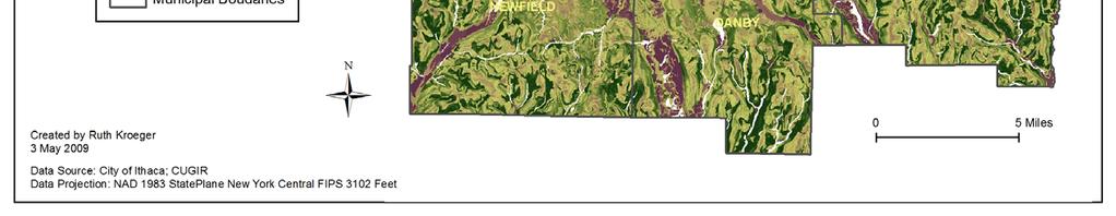
14 is concentrated. As expected, most development is concentrated around the center of the County in the Ithaca area. The southern part of Lansing is more urban than the north which tends to be mostly rural. Comparing Map 7 and Map 8 shows that, as expected, most of the urbanized areas in Tompkins County receive service from public sewer systems while most of the rural areas outside of the Ithaca metropolitan center have private septic systems. In particular, most of the town of Lansing has no public sewer service and relies on private individual septic systems. Comparing Map 7 with Map 9 does not reveal a strong correlation between income level and sewer service. The poorest part of the county (where median household income is less 50% of the median household income for the county) is located in downtown Ithaca, an area that is well serviced by Ithaca s public sewer system. The same is true for the areas downtown, to the southwest and northeast of the City of Ithaca were median household income is between 51% and 85% of the median county income. Most of this area is publicly serviced, except for the small area in the northeast corner of the Town of Ithaca. Median household income for the census tracts in Lansing is well above 100% of the median county household income, indicating that the town is fairly affluent and that poverty is not related to lack of public sewer service. Map 10 shows that most of the population growth between 1990 and 2000 in Tompkins County occurred towards the north of Ithaca, along the western (lake shore) side of the Village of Cayuga Heights) and in Lansing. In the southwestern corner of Lansing, the population grew by at least 20%. Map 7 shows that most of this high growth corner of Lansing currently relies on private septic systems. It is also important to note the area s proximity to Cayuga Lake and the potential for contamination of the lake should any of the private septic systems fail or even leak. Map 11 depicts the suitability of sites around Tompkins County for private septic systems based on the soil conditions, the distance to the seasonal high water table and the slope. As previously discussed, the best sites for soil absorption septic systems are those on permeable soils, with minimal slope, well up from the water table. The suitability study reveals that most of Lansing is, at most, only moderately suitable for onsite septic and the sites along Lake Cayuga are the least 14
15 suitable of all. The southwest corner where most of the population growth occurred (and which is currently dependent on private septic systems) is actually quite unsuitable for private septic given the area s soil conditions, slope and water table depth. 15
16 IV. Discussion and Conclusions This series of maps combined with the data from the Ithaca Journal suggest that Lansing is a good candidate for a public sewer plant. Most of the town is unsuitable for siting private septic systems and the risks of negative environmental impacts are high. Building a plant in this high growth area would minimize the environmental risks of soil and groundwater contamination through mineral loading and leaking septic tanks. Providing public service in the southern part of the town where the land is particularly unsuitable for septic systems would protect the environment and preserve the northern rural part of the town. In addition, the town and its residents seem financially more able to cope with the expense of building a sewage system than other municipalities in Tompkins County, particularly with the additional sources of funding cited in the Ithaca Journal. The debate apparent from the Ithaca Journal articles suggest that significant community resistance to the new plant may, in part, be a result of nimbyism. Current residents want to maintain the rural character of their community and to keep out newcomers or development they feel may arrive once a public sewer system is in place. Town officials should continue to encourage public debate around the issue and to work to educate the public about the environmental benefits of building a public sewage system and the ability to reduce sprawl and preserve rural areas that such a system would provide. They should also continue to stress the serious environmental and public health risks associated with private septic systems and the current potential for soil and water contamination from these poorly sited systems. 16
17 V. References Ashmore, Tim. Lansing outlines initial sewer system service area. The Ithaca Journal, June 29, 2007, 1B. E6B93180 (accessed May 3, 2009). CUGIR. Soil Survey CUGIR. Land Use/Land Cover Daley, Jennie. Lansing plans sewer system. The Ithaca Journal, January 15, 2005, 1B. 0E6B93180 (accessed May 3, 2009). EPA. Decentralized Systems Technology Factsheet: Septic Tank Soil Absorption Systems. September, (accessed May 2, 2009). EPA. Background and Use of Onsite Wastewater Treatment Systems. Chapter 1 in Onsite Wastewater Treatment Systems Manual, February (accessed May 2, 2009). EPA. Establishing Treatment System Performance Requirements. Chapter 3 in Onsite Wastewater Treatment Systems Manual, February (accessed May 2, 2009). Hill, David. Lansing town board tables sewer system. The Ithaca Journal, July 7, 2007, 1A (accessed May 3, 2009). Ithaca Journal Staff. Officials debate Lansing sewer line proposal. The Ithaca Journal, October 20, 2006, 1B. 6B93180 (accessed May 3, 2009). Ithaca Journal Staff. Lansing sewer project. The Ithaca Journal, December 6, 2006, 7A. E6B93180 (accessed May 3, 2009). King, Michelle. Lansing's $18M sewer project might get financial assistance from state. The Ithaca Journal, January 4, 2007, 1B. 0E6B93180 (accessed May 3, 2009). 17
18 Tompkins County NY, HAZUS-MN Risk Assessment Tool Hurricane Result. Appendix F of the Multi-Jurisdictional All Hazard DMA 2000 Mitigation Plan. %22 (accessed May 2009). United States Department of Agriculture. Soil Survey: Tompkins County, New York. July, Washington D.C. 18
 Map 1")
19 VI. Appendix (Maps) Map 1 19

20 Map 2 20

21 Map 3 21

22 Map 4 22

23 Map 5 23

24 Map 6 24

25 Map 7 25

26 Map 8 26
27 Map 9 27

28 Map 10 28


29 Map 11
Reference Guideline #1. Hydrogeological Impact Assessment
 Reference Guideline #1 Hydrogeological Impact Assessment Reference Guideline #1 Hydrogeological Impact Assessment Hydrogeological assessments are required for some subdivision applications when triggered
Borough of Hightstown (1104) Introduction
 Introduction") (1104) Introduction This municipal chapter is an element of the prepared by the Planning Division in accordance with N.J.A.C. 7:15. Hightstown Borough, an established, self-governing municipality, is located
(1104) Introduction This municipal chapter is an element of the prepared by the Planning Division in accordance with N.J.A.C. 7:15. Hightstown Borough, an established, self-governing municipality, is located
Existing Land Use. Proposed
 May 31, 2018 Staff Analysis of a Proposed Amendment to the Dane County Water Quality Plan Revising the Sewer Service Area Boundary in the Waunakee Urban Service Area 1) Existing Conditions a) Land Use
The nitrate contamination concern
 Section A The nitrate contamination concern In 1974, the U.S. Congress passed the Safe Drinking Water Act (SDWA). This law required the Environmental Protection Agency (EPA) to determine the level of contaminants
CHAPTER 6 SANITARY SEWER SUB-ELEMENT
 CHAPTER 6 SANITARY SEWER SUB-ELEMENT Page 1 of 10 CHAPTER 6 SANITARY SEWER SUB-ELEMENT A. OVERVIEW The following Future Land Use categories are considered to be urban and require the provision of sanitary
Table 5-1: Availability of Public Sanitary Sewer. Are plans underway to provide Public Sewer?
 CHAPTER 5: PUBLIC SANITARY SEWER AND PRIVATE WASTEWATER DISPOSAL; PUBLIC WATER SERVICE AND PRIVATE WELLS Public Sanitary Sewer The presence or absence of public sanitary sewer service is a major factor
INDIAN HILLS SOURCE WATER PROTECTION PLAN MEETING JANUARY 11, 2017
 INDIAN HILLS SOURCE WATER PROTECTION PLAN MEETING JANUARY 11, 2017 Jefferson County Public Health Environmental Health Services Division Our Mission: Promoting and protecting health across the lifespan
Borough of Mount Arlington (1426)
") (1426) Introduction This municipal chapter is an element of the Morris County Wastewater Management Plan prepared by the Morris County Department of Planning and Development in accordance with N.J.A.C.
(1426) Introduction This municipal chapter is an element of the Morris County Wastewater Management Plan prepared by the Morris County Department of Planning and Development in accordance with N.J.A.C.
GIS Analysis of Groundwater Transport of Septic Tank Phosphorous in Lake Nebagamon, Wis.
 GIS Analysis of Groundwater Transport of Septic Tank Phosphorous in Lake Nebagamon, Wis. Andrew Austin-Petersen GIS in Water Resources Falls 2016 Introduction Lakes in Wisconsin have long been a source
Appendix A Literature Review - Septic System Performance Criteria, Technologies, and Cost Factors
 Appendix A Literature Review - Septic System Performance Criteria, Technologies, and Cost Factors TECHNICAL MEMORANDUM Appendix A - Literature Review Septic System Performance Criteria, Technologies,
H. WATER RESOURCES. a. describe the characteristics, uses, and quality of Orland's significant water resources;
 H. WATER RESOURCES 1. Purpose This section will present an overview of Orland's water resources. An understanding of water resources is important since all residents must have a reliable source of drinking
Septic Improvement Program FAQs
 Septic Improvement Program FAQs Where does our waste go after we flush the toilet? Thanks to the simple push of a lever, waste remains out of sight and out of mind. According to the US EPA, about one-third
Ohio s Sewage Treatment System Rules
 Ohio s Sewage Treatment System Rules Residential Water and Sewage Program Bureau of Environmental Health ODH Sewage Rules Process 1 How is sewage treated across the state? Public sewage system permitted
Ohio s Sewage Treatment System Rules
 Ohio s Sewage Treatment System Rules Residential Water and Sewage Program Bureau of Environmental Health ODH Sewage Rules Process 1 How is sewage treated across the state? Public sewage system permitted
The Municipal Land Use Law, at N.J.S.A. 40:55D-89, includes the following statement relative to the periodic examination of a municipal Master Plan:
 2002 Periodic Reexamination Report of the Master Plan and Development Regulations for Lebanon Township, Hunterdon County, New Jersey May 16, 2002 (Adopted as revised on May 21, 2002) The Municipal Land
VII. WATER SUPPLY AND SEWAGE TREATMENT
 VII. WATER SUPPLY AND SEWAGE TREATMENT Water supply and sewage treatment are essential services accompanying the development of land for housing, non-profit and community institutions, commerce and industry.
Deriving Harvestable Area in Arcata Community Forest
 Deriving Harvestable Area in Arcata Community Forest By: Abstract Kittens with Mittens Corey Humphrey and Taylor Jensen The Arcata Community Forest (ACF), along with education and recreation, is used for
This is a digital document from the collections of the Wyoming Water Resources Data System (WRDS) Library.
 Library.") This is a digital document from the collections of the Wyoming Water Resources Data System (WRDS) Library. For additional information about this document and the document conversion process, please contact
This is a digital document from the collections of the Wyoming Water Resources Data System (WRDS) Library. For additional information about this document and the document conversion process, please contact
Chapter 5: regional Planning
 Chapter 5: regional Planning Regional planning is not unique to the Centre Region; however, it is often off of the radar of most residents and officials until they become involved in regional planning
Chapter 3 Regulatory Requirements, Policies and Sewer Agreements
 Chapter 3 Regulatory Requirements, Policies and Sewer Agreements \\7348101\TOC.doc CHAPTER 3 Regulatory Requirements, Policies and Sewer Agreements 3.1 STATE ENVIRONMENTAL POLICY ACT Washington Administrative
Rationale for Sewerage System Setbacks
 Sewerage System Regulation Section 3.1 (Setbacks) Rationale Section 3.1 of the amended Sewerage System Regulation (SSR) stipulates minimum setback distances for holding tanks and sewerage system septic
Minnesota Stewardship Spatial Analysis Project Methodology and Analysis documentation January 28, 2008
 Minnesota Stewardship Spatial Analysis Project Methodology and Analysis documentation January 28, 2008 Summary In the fall of 2004, Minnesota DNR and the U.S. Forest Service began working together to create
New York Rural Water Association. Local Source Water Protection and Smart Growth In Rural New York: A Guide For Local Officials
 New York Rural Water Association Local Source Water Protection and Smart Growth In Rural New York: A Guide For Local Officials Although the information in this document has been funded wholly or in part
Model Riparian Buffer Ordinance.
 Model Riparian Buffer Ordinance. This is a sample riparian buffer ordinance written as an amendment to an existing zoning ordinance. This ordinance complies with the state minimum standards for river corridor
CORTLAND COUNTY HEALTH DEPARTMENT RULES AND REGULATIONS MINIMUM LOT SIZE
 CORTLAND COUNTY HEALTH DEPARTMENT RULES AND REGULATIONS MINIMUM LOT SIZE USE OF INDIVIDUAL WASTEWATER TREATMENT SYSTEMS AND DRINKING WATER SUPPLY WELLS WHERE PUBLIC FACILITIES ARE NOT AVAILABLE Approved
New Jersey Forest Stewardship Program Spatial Analysis Project Map Products And Data Layers Descriptions
 New Jersey Forest Stewardship Program Spatial Analysis Project 2007 Map Products And Data Layers Descriptions 01/07 NJ Forest Stewardship Program (FSP) Spatial Analysis Project (SAP) Methodology Project
OAKLAND COUNTY HEALTH DIVISION SANITARY CODE ARTICLE II - GROUNDWATER PROTECTION
 OAKLAND COUNTY HEALTH DIVISION SANITARY CODE ARTICLE II - GROUNDWATER PROTECTION INDEX OF CODE SECTION 1 SECTION 2 SECTION 3 SECTION 4 SECTION 5 SECTION 6 DEFINITIONS RESIDENTIAL BUILDING SITES COMMERCIAL
CHAMBERS CREEK REGIONAL WASTEWATER TREATMENT PLANT FACILITIES PLAN 4. POPULATION, FLOW, AND LOADING PROJECTIONS
 CHAMBERS CREEK REGIONAL WASTEWATER TREATMENT PLANT FACILITIES PLAN 4. POPULATION, FLOW, AND LOADING PROJECTIONS The Chambers Creek Regional Wastewater Treatment Plant Facilities Plan (Facilities Plan)
CHAPTER SEVEN: UTILITIES
 CHAPTER SEVEN: UTILITIES 7.1 Introduction The Water Works Board of the City of Auburn (AWWB) is the primary potable water service provider for the City of Auburn (City) and Auburn University. There are
Renewable Energy Sources Evaluation. Beverly, Massachusetts Matt Tormey
 Renewable Energy Sources Evaluation Beverly, Massachusetts Matt Tormey Research Objective Explore and evaluate the potential for renewable energy sources in a New England community Evaluate two of three
Characteristics of Land Resources
 Chapter Chapter 1 Characteristics of Land Resources The geology, soils and topography of Woodford County T he geology, soils and topography of an area are important to the community planning process for
Instructions for Notice of Ground Disturbance Form:
 Instructions for Notice of Ground Disturbance Form: Prior to beginning any ground disturbance activity or finalizing your storm water plan, submit a completed 2 page Notice of Ground Disturbance Form to
Annual Drinking Water Quality Report for 2015 CAYUGA LAKE ESTATES 1458 STATE RT. 38 MORAVIA, NY (Public Water Supply ID# )
") Annual Drinking Water Quality Report for 2015 CAYUGA LAKE ESTATES 1458 STATE RT. 38 MORAVIA, NY 13118 (Public Water Supply ID# 0506426) INTRODUCTION To comply with State regulations, Cayuga Lake Estates,
Annual Drinking Water Quality Report for 2015 CAYUGA LAKE ESTATES 1458 STATE RT. 38 MORAVIA, NY 13118 (Public Water Supply ID# 0506426) INTRODUCTION To comply with State regulations, Cayuga Lake Estates,
Lecture 22: Groundwater Contamination I
 Lecture 22: Groundwater Contamination I Key Questions 1. What causes seawater intrusion? 2. What is the Gyben-Herzberg Relation (z = 40h) 3. Why are islands susceptible to sea-water intrusion? 4. What
Monitoring site - Indian Creek
 Indian Creek Watershed Management Plan GIS and EPA Bacteria Indicator Tool (BIT) February 17, 2009 2009 Indiana GIS Conference Bloomington Monroe County Convention Center Stacey Jarboe, Stantec t Consulting
OPTION ONE: Collective Management of Decentralized Onsite Wastewater Treatment and Disposal Systems
 APPENDIX B OPTION ONE: Collective Management of Decentralized Onsite Wastewater Treatment and Disposal Systems Option one is a community-generated option, not authored by CHS Engineers (the consultant).
Water District No. 111 of King County Annual Water Quality Report 2017
 Water District No. 111 of King County Annual Water Quality Report 2017 A Brief Introduction This is a snapshot of the quality of water served to you, your family, and the businesses within Water District
SEPTIC SYSTEMS LAZERWEB SERVICES
 SEPTIC SYSTEMS LAZERWEB SERVICES WWW.LAZERWEBSITES.COM Contents Septic Information for Homeowners...2 Septic Systems Frequently Asked Questions...2 What are septic systems?...3 Why are these systems called
Gallatin County. Regional Wastewater Management System Feasibility Study - Phase II Working Draft Report 9/17/2010
 Gallatin County Regional Wastewater Management System Feasibility Study - Phase II Working Draft Report 9/17/2010 Prepared for: Gallatin County 311 West Main Bozeman, MT 59715 406-582-3192 Prepared by:
Department of Environmental Conservation. Fiscal Year 2015 Performance Outcomes and Measures
 Department of Environmental Conservation Fiscal Year 2015 Performance Outcomes and Measures Department of Environmental Conservation Fiscal Year 2015 Performance Outcomes and Measures Department of Environmental
August 3, The proposed action thus includes Site Plan approval for the Fire Department and Amended Site Plan approval for the Ambulance Corps.
 Scoping Document For Preparation of a Draft Environmental Impact Statement For the Putnam Valley Volunteer Fire Department Site Plan and Putnam Valley Volunteer Ambulance Corps Amended Site Plan Town of
Farming at the Urban Edge
 Farming at the Urban Edge Preservation of farmland despite pressure from development and making farming profitable are not the only challenges facing farmers today. The location of the Prince George s
SCHERTZ ROADWAY IMPACT FEE
 SCHERTZ ROADWAY IMPACT FEE LAND USE ASSUMPTIONS FINAL REPORT Prepared for: City of Schertz October 2017 Prepared by: FREESE AND NICHOLS, INC. 2711 North Haskell Avenue, Suite 3300 Dallas, Texas 75204 TABLE
#613 Planning Basics Chapter 1: Sewage Facilities Planning
 CHAPTER OBJECTIVES: After completing this chapter, you will be able to... Explain the purpose and importance of sewage facilities planning. List the parties who are involved in the planning process. Explain
Lake Creek Watershed Management Plan Public Meeting. Arrowhead Lake May 3, :00 PM
 Lake Creek Watershed Management Plan Public Meeting Arrowhead Lake May 3, 2018 6:00 PM Agenda I. Welcome and Introductions II. III. IV. Watershed Basics Overview of Lake Creek Watershed Elements of a Successful
Statewide Parcel Database
 Statewide Parcel Database SUMMARY OF CONSUMER SURVEY Survey objectives In order to best design a statewide parcel database, it is necessary to understand the needs, limitations, and interest of the organizations,
Impact of Septic Tank Contamination at Te Puna
 Impact of Septic Tank Contamination at Te Puna Prepared by Paul Futter, Project Implementation Officer Environment Bay of Plenty June 2003 Update 5 Quay Street P O Box 364 Whakatane NEW ZEALAND ISSN 1175-9372
Managing On-Site Wastewater Disposal Systems
 Managing On-Site Wastewater Disposal Systems Problem In the Buzzards Bay drainage basin, 43% of the population, or more than 100,000 people, use on-site wastewater disposal systems. Moreover, most of the
GENERAL PLAN CHAPTER 3.8, INFRASTRUCTURE
 Attachment D GENERAL PLAN CHAPTER 3.8, INFRASTRUCTURE Background- Senate Bill 244 (SB 244) requires that counties include in their Land Use Element identification and analysis of disadvantaged unincorporated
GP_ DISADVANTAGED UNINCORPORATED COMMUNITIES ASSESSMENT
 COUNTY OF MENDOCINO DEPARTMENT OF PLANNING AND BUILDING SERVICES 860 NORTH BUSH STREET UKIAH CALIFORNIA 95482 120 WEST FIR STREET FT. BRAGG CALIFORNIA 95437 STEVE DUNNICLIFF, DIRECTOR PHONE: 707-234-6650
Appendix K. Project Opportunity Scoring Worksheet and Web Map References
 Appendix K Project Opportunity Scoring Worksheet and Web Map References Project Opportunity Scoring Sheet ARB SWRP Project Opportunity Matrix and Scoring Worksheet Project Name (Enter Title of Your Choice)
Municipal Service Review
 Redway Community Services District Municipal Service Review July 2008 Prepared by: For the District Sphere of Influence Report TABLE OF CONTENTS Page Local Agency Formation Commission Authority... 1 Agency
Municipal Service Review
 Willow Creek Community Services District Municipal Service Review May 2008 Prepared by: For the District Sphere of Influence Report TABLE OF CONTENTS Page Local Agency Formation Commission Authority...
WQMP AMENDMENT REVIEW CHECKLIST
 State of New Jersey Highlands Water Protection and Planning Council 100 North Road (Route 513) Chester, New Jersey 07930-2322 (908) 879-6737 (908) 879-4205 (fax) www.highlands.state.nj.us WQMP AMENDMENT
Impact of the September 4, 2010 Canterbury Earthquake on Nitrogen and Chloride. Concentrations in Groundwater
 Abstract Impact of the September 4, 2010 Canterbury Earthquake on Nitrogen and Chloride Concentrations in Groundwater Tara Seely 14/6/11 On September 4, 2010, the Canterbury region of New Zealand was hit
The Johns Hopkins University Zanvyl Krieger School of Arts and Sciences Advanced Academic Programs
 Zanvyl Krieger School of Arts and Sciences Advanced Academic Programs Master of Science in Environmental Sciences and Policy Environmental Planning Concentration Independent Graduate Project in Environmental
SPATIAL ANALYSIS OF POTENTIAL IMPACTS OF LOCAL FORESTRY ORDINANCES
 SPATIAL ANALYSIS OF POTENTIAL IMPACTS OF LOCAL FORESTRY ORDINANCES David R. Daversa, Stephen P. Prisley, and Michael J. Mortimer Department of Forestry, Virginia Tech, Blacksburg, VA 24061 ABSTRACT Local
2.1 Summary of Existing and Future Population Estimates
 SECTION 2 Demographics This technical memorandum identifies the uncertainties and describes potential future demographics that might affect wastewater facilities in the City of McCall, Idaho (the City).
2 COMMUNITY P. average number of days with any measurable precipitation is 112. On average, there are 205 sunny days per year
 2 COMMUNITY P PROFILE Chapter 2 provides a profile of the City of Forest Hills planning area and identifies capabilities already in place in the city to help mitigate hazards addressed in this plan. 2.1
Chapter DRINKING WATER
 Whatcom County Code Chapter 24.11 DRINKING WATER Page 1 of 30 Sections: 24.11.010 Authority. 24.11.020 Purpose. 24.11.030 Adoption by reference. 24.11.040 Definitions. 24.11.050 General requirements. 24.11.060
UPDATE. Funding Decentralized Wastewater Systems Using the Clean Water State Revolving Fund ACTIVITY
 Clean Water ACTIVITY Funding Decentralized Wastewater Systems Using the Clean Water T he Clean Water (CWSRF) is a low-interest or no-interest source of funding for the installation, repair, and upgrading
Executive Summary. The Louis Berger Group, Inc. FINAL DRAFT Page ES-1
 The Chesapeake Bay Bridge Tunnel (CBBT) Commission recently began consideration of a toll discount for commuters on its facility connecting the Eastern Shore of Virginia with the Hampton Roads metropolitan
CHAPTER SEVEN: UTILITIES
 CHAPTER SEVEN: UTILITIES 7.0 Introduction T he Water Works Board of the City of Auburn (AWWB) is the primary potable water service provider for the City of Auburn (City) and Auburn University. There are
Technical and Physical Feasibility Fact Sheet Alternative 28: Infill/Density
 Technical and Physical Feasibility Fact Sheet Alternative 28: Infill/Density Acknowledgements: This fact sheet was written by Phyllis Taylor of Sites Southwest as part of the Evaluation of Alternative
CHAPTER SEVEN: UTILITIES
 CHAPTER SEVEN: UTILITIES 7.1 Introduction T he Water Works Board of the City of Auburn (AWWB) is the primary potable water service provider for the City of Auburn (City) and Auburn University. There are
Clackamas County Septic Systems 101. Brannon Lamp, REHS
 Clackamas County Septic Systems 101 Brannon Lamp, REHS What is a Septic System? Definition of Septic : Infected with Bacteria. Hmmm What does a Septic System Do? Treatment Disposal Dispersal Recycling
Agriculture & Farmland Protection Plan
 Town of Sparta, N.Y. Agriculture & Farmland Protection Plan Executive aaaaaaaaaaaa Summary November 2018 This report is funded in part through a grant from NYS Department of Agriculture & Markets Acknowledgements
M A R C H 7, KC Water Cost of Service Task Force Meeting #10
 M A R C H 7, 2 0 1 7 KC Water Cost of Service Task Force Meeting #10 Agenda Findings and Recommendations Recap Customer Assistance System Development Charges Adjusting Rates to Cover Costs Irrigation Charge
Presenters: Laura DeBeer & Brent Hoffmann
 Presenters: Laura DeBeer & Brent Hoffmann A little background. Minnesota has 970 Community Water Supply Systems 726 are Municipal Water Supply Systems In 2015 there was 17 systems that had nitrates samples
Where does our drinking water come from in WNY? (here)
") 1 Page Where does our drinking water come from in WNY? (here) What are Combined Sewers? (Lake Erie) Combined sewer systems (CSS) are designed to collect storm water runoff, sewage, and industrial wastewater
1 Page Where does our drinking water come from in WNY? (here) What are Combined Sewers? (Lake Erie) Combined sewer systems (CSS) are designed to collect storm water runoff, sewage, and industrial wastewater
Groundwater Flow Evaluation and Spatial Geochemical Analysis of the Queen City Aquifer, Texas
 Groundwater Flow Evaluation and Spatial Geochemical Analysis of the Queen City Aquifer, Texas Abstract The Queen City Aquifer is a saturated sandstone unit in the coastal plain of East Texas. The goals
SEWRPC Staff Memorandum RESPONSE TO REQUESTS BY THE CITY OF NEW BERLIN TO DELINEATE THE 20-YEAR PLANNED WATER SUPPLY SERVICE AREA FOR THE UTILITY
 SEWRPC Staff Memorandum RESPONSE TO REQUESTS BY THE CITY OF NEW BERLIN TO DELINEATE THE 20-YEAR PLANNED WATER SUPPLY SERVICE AREA FOR THE UTILITY INTRODUCTION AND BACKGROUND By letter of January 12, 2009,
Contractors, Illicit Discharges, & Best Management Practices. Chris Allen Stormwater Inspector
 Contractors, Illicit Discharges, & Best Management Practices Chris Allen Stormwater Inspector What is an Illicit Discharge? Georgetown County Stormwater Ordinance defines an Illicit Discharge as: Any activity
PHYSICAL INTEGRITY: IMPACT OF URBAN AREAS ON GREAT LAKES WATER QUALITY
 Chapter One PHYSICAL INTEGRITY: IMPACT OF URBAN AREAS ON GREAT LAKES WATER QUALITY Introduction The need to plan and manage urban growth and mitigate its impact on the natural environment, particularly
SECTION 3 NATURAL RESOURCES
 SECTION 3 NATURAL RESOURCES The natural environment plays a large role in planning for future development. Environmental conditions, such as topography, wetlands, floodplains, and water bodies, can often
Population Projections:
 Two West 2nd Street, Suite 800 Tulsa, OK 74103 PHONE: 918.584.7526 FAX: 918.583.1024 EMAIL: transportation@incog.org The methodology for projecting and allocating, 2005 to 2035 Introduction In order to
Annual Drinking Water Quality Report Village of Chatham, NY 77 Main St., Chatham, NY (Public Water Supply ID# ) June 1, 2011
 June 1, 2011") INTRODUCTION Annual Drinking Water Quality Report Village of Chatham, NY 77 Main St., Chatham, NY 12037 (Public Water Supply ID#1000234) June 1, 2011 To comply with State regulations, the Village of Chatham,
INTRODUCTION Annual Drinking Water Quality Report Village of Chatham, NY 77 Main St., Chatham, NY 12037 (Public Water Supply ID#1000234) June 1, 2011 To comply with State regulations, the Village of Chatham,
Lecture 23: Groundwater Contamination
 Lecture 23: Groundwater Contamination Key Questions 1. What are some examples of point sources of groundwater contamination? 2. What are some examples of non-point sources of groundwater contamination?
Incremental Recycled Water Program 2007 ADDENDUM TO PROGRAM ENVIRONMENTAL IMPACT REPORT
 SANTA ROSA SUBREGIONAL WATER REUSE SYSTEM Incremental Recycled Water Program 2007 ADDENDUM TO PROGRAM ENVIRONMENTAL IMPACT REPORT SCH #2002072046 March 2007 SANTA ROSA SUBREGIONAL WATER REUSE SYSTEM 2007
YUCCA MOUNTAIN TRANSPORTATION IMPACTS IN NEVADA
 YUCCA MOUNTAIN TRANSPORTATION IMPACTS IN NEVADA The picture above depicts the 800-meter radiological region of influence along the Union Pacific railroad through Las Vegas, NV 6/22/2012 Population trends
2015 Annual Drinking Water Quality Report Wells College Water Department PO Box 500 Aurora, NY (Public Water Supply ID# )
") 2015 Annual Drinking Water Quality Report Wells College Water Department PO Box 500 Aurora, NY 13026 (Public Water Supply ID#0512920) INTRODUCTION To comply with State regulations, Wells College Water
2015 Annual Drinking Water Quality Report Wells College Water Department PO Box 500 Aurora, NY 13026 (Public Water Supply ID#0512920) INTRODUCTION To comply with State regulations, Wells College Water
Catchment Water Quality Protection
 Catchment Water Quality Protection Policy and Guidelines for Planning Permit Applications & Government Planning Initiatives Final31 Oct 2013 Policy Coliban Water s vision is to contribute to improving
ON-SITE WASTEWATER MANAGEMENT POLICY
 ON-SITE WASTEWATER MANAGEMENT POLICY Responsible Department: Responsible Section: Responsible Officer: Planning and Development Strategy and Land Use Senior Health & Environmental Coordinator Objectives
Chapter 8-Sanitary Sewer
 Chapter -Sanitary Sewer Executive Summary Background The Metropolitan Land Planning Act (amended 1995) requires local governments to prepare comprehensive plans and submit them to the Metropolitan Council
TOILET TO TAP A California county is tapping controversial sources for drinking water
 CHAPTER 14 FRESHWATER RESOURCES TOILET TO TAP A California county is tapping controversial sources for drinking water 14 TOILET TO TAP A California county is tapping controversial sources for drinking
Madison Water Utility Pressure Zone 4 Well Siting Study
 Madison Water Utility Summary of Potential Well Sites March 24 2011 Site Status Comment 1 Dairy Center In consideration Several suitable properties in this area are available. 2 Tradewinds In consideration
WESTMORELAND COUNTY A SUCCESSFUL MASTER SEWER SYSTEM PLAN FOLLOWED TO COMPLETION
 WESTMORELAND COUNTY A SUCCESSFUL MASTER SEWER SYSTEM PLAN FOLLOWED TO COMPLETION Written by Charles Riedlinger, P.E. and Norm Risavi, County Administrator INTRODUCTION In 1995, Resource International,
Henderson Watershed WRIA 13. Chapter Includes: Tanglewilde Stormwater Outfall Woodard Creek Woodland Creek
 Henderson Watershed WRIA 13 Chapter Includes: Tanglewilde Stormwater Outfall Woodard Creek Woodland Creek 146 Tanglewilde Stormwater Outfall PART OF HENDERSON WATERSHED PRIMARY LAND USES: Urban residential
The Impacts of Oil and Natural Gas Activities on ALR Land in the Peace River Valley of Northern British Columbia Katie Eistetter 2015
 The Impacts of Oil and Natural Gas Activities on ALR Land in the Peace River Valley of Northern British Columbia Katie Eistetter 2015 Introduction, Background and Study Area British Columbia has one of
Infrastructure. 7.1 Overview Goals, Objectives, and Policies A. Stormwater Management B. Sanitary Sewer System...
 Infrastructure 7 7 Infrastructure 7.1 Overview... 7-1 7.2 Goals, Objectives, and Policies..... 7-3 A. Stormwater Management..... 7-3 B. Sanitary Sewer System... 7-4 7.0 Infrastructure 7.1 OVERVIEW Priority
DEPARTMENT OF PUBLIC HEALTH Division of Environmental Health Onsite Water Protection Section
 DEPARTMENT OF PUBLIC HEALTH Division of Environmental Health Onsite Water Protection Section Our Mission: Working with our community to prevent disease, promote health and protect the environment. Our
Prepared Under the Direction of: Village of Spring Valley Plan Commission
 Village of Spring Valley Comprehensive Plan 2009 2029 Prepared Under the Direction of: Village of Spring Valley Plan Commission Rich O'Connell Marsha Brunkhorst Kathy Klug Gordon Grant Elizabeth Erickson
Secondary and Cumulative Effects Analysis Guidelines
 Maryland State Highway Administration s Secondary and Cumulative Effects Analysis Guidelines For Environmental Impact Statements and Environmental Assessments Revised 6/28/00 I. INTRODUCTION In compliance
HCA ANALYSIS & DRINKING WATER UNUSUALLY SENSITIVE AREA ASSESSMENT
 HCA ANALYSIS & DRINKING WATER UNUSUALLY SENSITIVE AREA ASSESSMENT MANAGING DOLLARS AND SENSE David Lehmann, P.G., Ph.D. Julienne Franco Houston, Texas Perceptions of Environmental Expense$$$$ Liability!!!
Living in the Chesapeake Bay Watershed. far-removed from every day life, only remembered when its time to go on holiday.
 Delilah Torres March 19, 2008 Environmental Policies Living in the Chesapeake Bay Watershed For people living in more urban areas, the Chesapeake Bay may seem like it is extremely far-removed from every
Draft Future Land Use Chapter as Presented to the Danville Planning Board February 24, Future Land Use 1-1
 1. Future Land Use 1-1 FUTURE LAND USE Introduction The Future Land Use section of the Master Plan reflects the desired long-range development pattern for Danville. It is a plan designed to encourage compatible
Public Sewer and Water Service
 Vibrant. Green. Connected. Competitive. Public Sewer and Water Service Statement of Purpose Ensuring that all of the region s residents have an adequate and consistently high quality water supply is of
DE PWS ID# DE , 2018 (RE:
 Annual Drinking Water Quality Report Georgetown Water Department 39 The Circle, Georgetown, DE 19947 PWS ID# DE0000542 May 10, 2018 (RE: Calendar Year 2017) We're pleased to present to you this year's
A 25 Year Strategic Plan
 A 25 Year Strategic Plan The challenges which face the provision of water services are identified as: Meeting Customer Needs at an Affordable Cost Providing Safe Water Supplies Managing Wastewater Protecting
COLVOS PASSAGE YUKON HARBOR WATERSHED
 COLVOS PASSAGE YUKON HARBOR WATERSHED 2014 Water Quality Monitoring Report Kitsap Public Health District 1 2 COLVOS PASSAGE / YUKON HARBOR WATERSHED The Colvos Passage / Yukon Harbor (CP/YH) watershed,