COMPREHENSIVE SANITARY SURVEY ALABAMA S AREA I SHELLFISH GROWING WATERS MOBILE & BALDWIN COUNTIES. Survey Dates:
|
|
|
- Domenic Carr
- 5 years ago
- Views:
Transcription
1 2007 COMPREHENSIVE SANITARY SURVEY OF ALABAMA S AREA I SHELLFISH GROWING WATERS IN MOBILE & BALDWIN COUNTIES Survey Dates: Revision Dates: May - October, 2008 Prepared by: Christine Collins Maps, Charts and Graphs provided by: AL Dept. of Conservation and Natural Resources-Marine Resource Division, AL Dept. of Environmental Management, AL Dept. of Public Health-Mobile County/Baldwin County, Alabama Department of Public Health Seafood Branch, and AL Oil and Gas Board Edited by: Toni Ackerson Alabama Department of Public Health Seafood Branch Division of Food, Milk & Lodging 4168 Commanders Drive Mobile, Alabama 36615
2 Table of Contents Area I Pages Definitions 1-2 Chapter I. Introduction 3 Oyster Landings: Table (I-1) Appendix Chapter II. Description of Growing Areas A. Description and Map of Growing Areas 4 B. Description of Area I 5 C. Classification History Area I 6 D. General Area Management Plan Area I 6 E. Procedures for Closure Area I 6-7 F. Procedures for Reopening Area I 7-8 Oyster Cleansing Process: (Table II-1) Appendix G. Working Days Closed Area I ( ) 8 Closure/Reopening Details Area I: Table (II-2) Appendix Chapter III. Pollution Source Survey A. Pollution Source Identification and Evaluation Area I 9 1. Domestic Wastewater Treatment Plants Area I 10 a. Dauphin Island WWTP Inventory 11 b. Fairhope Public Utilities WWTP Inventory Septic Systems Area I 13 a. Watersheds Affecting Area I 14 i
3 3. Marinas and Moorings Area I Hurricanes Storm water Area I Agricultural Waste Area I Wildlife Area I Industrial Operations Area I Marine Biotoxins 20 a Red Tide Event: Table (III-1) Appendix b Red Tide Event: Table (III-2) Appendix 10. Routine Dinoflagellate Testing Area I 21 a Dino Sampling: Table (III-3) Appendix 11. Map of Natural Gas Platforms Description of Natural Gas Platforms 23 Chapter IV. Water Quality Studies A. Sampling Plan, Station Descriptions, Map Area I Confirming Survey for Sampling Plan Area I 25 a Data Analysis Area I: Table (IV-1) Appendix B. Sample Data Analysis Area I ( ) Last 30 Bacteriological Samples for Each Station All Bacteriological Samples Area I Chapter V. Summary 45 ii
4 Appendices Table (I-1) Table (II-1) Table (II-2) Table (III-1) Table (III-2) Table (III-3) Table (IV-1) iii
5 Definitions 14/43 STANDARD means the NSSP bacteriological water quality standard for fecal coliform bacteria for water approved for direct market of shellfish. The median or geometric mean shall not exceed 14 MPN/100 ml of water, and MPN values of water shall not exceed 43 MPN/100 ml more than 10% of the time. AMPC means Above Management Plan Conditions. AMPC are those conditions when fecal coliform have historically been demonstrated to be elevated above the 14/43 as determined by regression analysis. APC means Adverse Pollution Conditions. APC are those conditions when fecal coliform have historically been demonstrated to be elevated. APPROVED is a shellfish harvesting area classification of the National Shellfish Sanitation Program for the harvest of shellfish for direct consumption. A survey indicates that the approved waters are removed from actual and potential pollution sources so that fecal material, pathogenic microorganisms, and poisonous or deleterious substances are not present in dangerous concentrations. At least fifteen of the most recent samples collected at each station during adverse pollution conditions are used to determine compliance with the 14/43 fecal coliform standard. An approved area must meet the 14/43 fecal coliform standard at all times the area is open to shellfish harvesting, including during adverse pollution conditions. CONDITIONALLY APPROVED is a shellfish harvesting area classification of the National Shellfish Sanitation Program for the harvest of shellfish for direct consumption. A survey indicates that poisonous and deleterious substances are not present, microbiological pollution is intermittent and conditions associated with the release, persistence, and distribution of bacterial pollution are known. At least fifteen (THIRTY) of the most recent samples collected at each station during ALL TYPES OF SAMPLING conditions are used to determine compliance with the 14/43 fecal coliform standard. The survey must clearly demonstrate that the area will meet approved area classification criteria when the area is used as a source of shellfish for direct market. CONDITIONALLY RESTRICTED is a shellfish harvesting area classification of the National Shellfish Sanitation Program. A survey indicates that the area is not so contaminated with concentration levels of poisonous, deleterious, or microbiological substances that shellfish consumption would not be hazardous following harvest and subjection to a suitable and effective treatment process of relay or depuration. Since bacteriological pollution is intermittent, the survey must define the conditions associated with release, persistence, and distribution of bacterial pollution. At least fifteen of the most recent samples collected at each station during adverse pollution conditions are used to determine compliance with the 88/260 fecal coliform standard. The survey must clearly demonstrate that the area will meet restricted area classification criteria when the area is used as a source of shellfish. Shellfish harvesting from conditionally restricted areas is allowed only by special license and requires State approved monitoring. DATE means date that samples are collected. FC means fecal coliform bacteria (MPN/100 ml for water, MPN/100 g for shellfish meat). FDA means the U.S. Food and Drug Administration. HARVEST means removing shellfish from shellfish harvesting areas and its placement on or in a manmade conveyance or other means of transport. ISSC means the Interstate Shellfish Sanitation Conference. 1
6 LOGFC means log(base 10)-transformed fecal coliform value. ML means milliliter. MPC means Management Plan Conditions where fecal coliform have not been historically demonstrated to be elevated above the 14/43 STANDARD; as determined by previous analysis. MPN means Most Probable Number. MPN is a statistical estimate of the number of bacteria. NSSP means the National Shellfish Sanitation Program. PRODUCT-MOMENT CORRELATION is a statistical procedure that measures the closeness of linear relationship between two variables. PROHIBITED is a shellfish harvesting area classification of the National Shellfish Sanitation Program. A survey indicates that sampling results indicate fecal material, pathogenic microorganisms, or poisonous or deleterious substances are consistently or unpredictably present in dangerous concentrations, or the shoreline survey identifies actual or potential pollution sources of high magnitude which may affect the growing area. No shellfish may be harvested from prohibited areas for human consumption. RANK CORRELATION is a statistical procedure that measures the degree of association between the ranks of two data sets, without considering magnitude of the data values. REGRESSION is a statistical procedure that defines an equation of a line through a set of paired data points, such that the sum of the squares of the vertical distances from the data points to the line is minimized. RESTRICTED is a shellfish harvesting area classification of the National Shellfish Sanitation Program. A survey indicates that the area is not so contaminated with poisonous and deleterious substances that the consumption of shellfish would not be hazardous after relaying and/or undergoing a controlled purification process. At least fifteen of the most recent samples collected at each station during adverse pollution conditions are used to determine compliance with the 88/260 fecal coliform standard. The bacteriological water quality of every station in the restricted area must meet the 88/260 standard. Shellfish harvesting from restricted areas is allowed only by special license and requires State approved monitoring. RIVER STAGE means documented height of the Mobile River as gauged by the Army Corp of Engineers at Barry Steam Plant in Bucks, Alabama. SHELLFISH means edible species of oysters, clams and mussels. SHELLFISH HARVESTING AREA means the water extents of an area classified by the Alabama Department of Public Health s Administrative Code for the harvest of shellfish. SHORELINE SURVEY AREA means the water and land extents where actual or potential pollution sources are determined to impact water quality of the shellfish harvesting area. TIDE means the tidal stage when samples are collected. UNCLASSIFIED is a shellfish harvesting area classification. Areas are designated Unclassified in the absence of a comprehensive shellfish harvesting area survey. No shellfish may be harvested for human consumption from Unclassified areas. 2
7 INTRODUCTION AREA I Shellfish are an important aquatic species with great economic value. (appendix: Table I-1 ) Shellfish are filter-feeding mollusks usually found abundantly in Alabama s subtidal coastal waters. One shellfish may filter up to 400 gallons of water per day while feeding. Shellfish retain and concentrate up to 100 fold much of the suspended and dissolved materials, including microorganisms, chemical contaminants, bacteria and viruses. They are passive vectors of enteric diseases, including typhoid, hepatitis and salmonellosis. Excluding the shell, the entire animal including the gastrointestinal tract is consumed. If contaminated, shellfish present a potential health hazard to the consumer since they are often eaten raw or partially cooked. Alabama is a member of the Interstate Shellfish Sanitation Conference (ISSC), a cooperative, voluntary association of the states; U.S. Food and Drug Administration (FDA); National Marine Fisheries Services (NMFS); Environmental Protection Agency (EPA); and the shellfish industry. The ISSC meets every other year to develop and revise methods of shellfish sanitation for adoption by the Conference under guidance from FDA and the National Shellfish Sanitation Program (NSSP). FDA s responsibilities include reviewing each state s shellfish control program to determine conformity with the NSSP. The FDA incorporates changes into the NSSP Model Ordinance, which defines the standards and guidelines used nationally for the classification of shellfish harvesting areas. NMFS and EPA responsibilities include acting as consultants to the ISSC. State responsibilities include adopting laws and regulations for sanitary control of the shellfish industry, formulating comprehensive shellfish harvesting area surveys, conducting laboratory investigations, and adopting controls to ensure that shellfish are grown, harvested, and processed in a safe and sanitary manner. The Shellfish Sanitation Rules of the State Board of Health, Bureau of Environmental Services, Division of Food, Milk, and Lodging, Chapter , were revised and adopted on November 19, 2003 and became effective on December 25, The National Shellfish Sanitation Program Guide for the Control of Molluscan Shellfish, 2001 Revision, was simultaneously incorporated by reference and made a part of Alabama s Shellfish Sanitation Rules. These documents contain the criteria applied to Alabama s shellfish growing areas for classification and management purposes. Shellfish industry s responsibilities include cooperating with control authorities by obtaining shellfish only from safe sources, maintaining sanitary operating conditions and practices, and keeping and making available to control authorities records documenting the origin and disposition of all shellfish. This comprehensive survey is an evaluation and report of all environmental factors, including actual and potential pollution sources which have an impact on the water quality of the shellfish harvesting areas of the state of Alabama. It includes a shoreline survey, an evaluation of the effects of any meteorological, hydrodynamic, and geographic characteristics on the growing areas; a survey of bacteriological water quality, and an analysis of the data. It is the basis for the classification and management of the area as conditionally approved. This classification has been in effect since 1992 and remains the same as a result of routine updates, reviews, and incorporated evaluations of recent information. This survey will be updated through a triennial evaluation and an annual review to assure that the data is current and the classifications remain appropriate. This survey will expire and another complete survey will be performed within twelve years. 3
, Area II, Area III, and Area IV (classified as Prohibited), LOCATION MAP SHOWING GROWING AREAS 4")
8 CHAPTER II.A. DESCRIPTION OF GROWING AREAS There are four designated Alabama shellfish growing areas in Mobile Bay; Area I which includes Area I-1 (classified Restricted and managed as Prohibited), Area II, Area III, and Area IV (classified as Prohibited), LOCATION MAP SHOWING GROWING AREAS 4
9 II.B. DESCRIPTION OF AREA I Area I is classified as Conditionally Approved. The northern boundary of Area I is a line extending in an eastward direction from the south shore of East Fowl River at the mouth to East Fowl River Channel Marker No. 2, then in an eastward direction to Marker No. 51 at the Mobile Ship Channel, then in a northeastward direction to Daphne. The eastern boundary of Area I is a line that extends from the westernmost tip of Fort Morgan Peninsula to Mullet Point. The western boundary of Area I is a line that extends from Barron Point westward to the southern tip of Isle Aux Herbes (Coffee Island), then westward to Marker No. 17 at Bayou La Batre Ship Channel, then due south to Dauphin Island. CLASSIFICATION EXCEPTIONS TO AREA I 1. The area lying south of a line extending from Marker No. 51 at the Mobile Bay Ship Channel, then in a northeastward direction to Daphne. The southern boundary is a line extending due east from Marker No. 51 at the Mobile Bay Ship Channel to intersect the beach. This portion of Area I is designated Restricted. 2. That portion of waters extending 1,000 feet from the Fairhope Sewage Treatment outfall. This portion of Area I is designated Prohibited. 3. That portion of waters extending 1,000 feet from the mouth of the cove containing the marina at the Marriott Grand Hotel. This portion of Area I is designated Prohibited. 4. Access canals to Heron Bay, west of and adjacent to Alabama Highway 193. This portion of Area I is designated Prohibited. 5. That portion of Aloe Bay and adjoining waters, lying south of a line extending eastward from the northeast corner of the Dauphin Island Airstrip to the marked bridge piling (at Bent Cap #AL-P14 54-C) on the west side of Dauphin Island Bridge where it crosses the northwest portion of Little Dauphin Island, then extending south along the bridge to Chaugae Point on Dauphin Island. This area also includes all waters 1,000 feet north of a line extending from the northwest corner of the Dauphin Island Airstrip to the north end of Port Royal Street at Lafitte Bay. This portion of Area I is designated Prohibited. 6. That portion of Dauphin Island Bay and adjoining waters lying south of a line extending southeastward from the marked bridge piling (at Bent Cap #AL-P14 54-C) on the east side of the Dauphin Island Bridge where it crosses the northwest portion of Little Dauphin Island, to Dauphin Island Channel Marker No. 14 at Confederate Pass. This portion of Area I is designated Prohibited. 7. All of Quivera Bay, all of Polaris Lagoon, all of Lafitte Bay, all of Port Royal Lagoon and all of Graveline Bay including Bayou Heron Canal/Salt Creek. This portion of Area I is designated Restricted. 8. The following bays and canals adjoining Dauphin Island Bay are Unclassified, including but not limited to: Indian Bay, Indian Canal, Buchanan Bay, Confederate Pass, British Bay, Columbia Bay, Colony Bay, Spanish Bay, Barcelona Bay, Government Cut, and Billy Goat Hole. 5
10 II.C. CLASSIFICATION HISTORY - GROWING AREA I The conditional management plan for Area I is based on determinations made from regression analyses performed in A conditional management plan document entitled A Management Plan for Area I and II of Mobile Bay, dated July 26, 1991 describes how the eight foot river stage at the Barry Steam Plant on the Mobile River was selected to be the management criteria. Data used in this document to classify Area I came from bay water samples collected from the original Area II /II-C (now Area I) during the period from A total of 1,024 samples were collected during all river stages and that data was analyzed for the relationships between fecal coliform counts, and high and low river stages, which reflected predictive positive probability conditions of high fecal coliform counts (defined as >=14) existing when high river stages (defined as > =8) were present. Conditional management plans are required to include performance standards, discussions, and data supporting these performance standards. The performance standards are the environmental conditions identified for the closure and reopening of the growing area. Water and/or oyster sample results are compared to performance standard levels, which in turn, results in the appropriate action being taken, closure or subsequent reopening of the harvest area. Other criteria for area closures included any pollution source(s) causing the performance standards to fall below acceptable limits, whether it be fecal coliform, marine biotoxins, or other deleterious substances. The original survey for Alabama s Management Plan was conducted by the Alabama Department of Public Health-Seafood Branch in This survey superceded a November 20, 1990 fecal coliform monitoring plan. The 1991 survey resulted in the present conditional management plan where closure (for predictive high fecal samples being > =14) was predominantly based on river stage (reaching eight feet at Barry Steam Plant). Annual and Triennial Reevaluation sanitary survey update reports based on the NSSP Model Ordinance requirements are on file with ADPH Seafood Branch ( ). The previous comprehensive sanitary survey of Mobile Bay s shellfish growing waters was complete in II.D. GENERAL AREA MANAGEMENT PLAN GROWING AREA I Temporary closures for Conditionally Approved harvest areas are based on trigger points which are representative of conditions that exist when shellstock are most probably unsafe for human consumption. The present management plan closes a shellfish harvesting area during any of the following conditions: 1) when there is discharge or spillage of any substance that is considered hazardous to public health, 2) when there is the presence of biotoxins in concentration levels deemed to be detrimental to the public health, 3) when the stage of the Mobile River reaches eight (8) feet at Barry Steam Plant, Bucks, Alabama as measured and reported by the Army Corps of Engineers, Mobile District Water Information Center, or 4) any other event such as a tropical storm, hurricane, tidal surge, etc. that could pose any significant potential public health threat. Closures resulting from discharges or spillage of hazardous substances and unusual weather events (tropical storms, hurricanes, heavy rains greater than 5 inches) are defined as Emergency Closures. II.E. PROCEDURES FOR CLOSURE GROWING AREA I 1) Hazardous discharge or spillage of any substance which could adversely affect shellfish growing waters would be reported to the Seafood Branch by any one of the following agencies: Alabama Dept. of Environmental Management (ADEM), the U.S. Coast Guard, or the U.S. Army Corps of Engineers. ADPH-Seafood Branch would then notify ADPH-Montgomery who would actually issue the 6
11 Closure Order. ADPH-Seafood would then contact ADCNR-MRD (who would physically enforce the Closure Order), Alabama s FDA Shellfish Specialist, the Baldwin and/or Mobile County Health Department, and the ISSC. All correspondences will transpire through contacts made by telephone, fax, radio, and/or . ADPH will continue to answer any phone calls from the general public about the closure. 2) The presence of harmful biotoxins in shellfish growing waters and/or oysters would be reported by ADPH Mobile Laboratory according to the procedures in the Alabama Harmful Algal Bloom Response Plan The lab results would be distributed to State, Local, and Federal Agencies. Once ADPH-Seafood Branch and ADPH Central Office receives results of probable biotoxin contamination, they both would coordinate to prepare for further event monitoring and proceed to area closure protocol. All correspondences will transpire through contacts made by telephone, fax, radio, and/or . ADPH will continue to answer any phone calls from the general public about the closure. 3) Whenever the Mobile River stage nears 8', particularly during a heavy rain event (according to the U.S. Army Corps of Engineers web-page or phone information line), ADPH-Seafood will continue to monitor the river stage. The Seafood Branch notifies ADCNR-MRD that the river stage is nearing 8'and probable closure is likely. If the river stage rises above 8', ADPH issues a Closure Notice and Order, and contacts ADCNR-MRD by telephone, fax, or radio, so they can enforce the order. Also, Alabama s FDA Shellfish Specialist, the Baldwin and/or Mobile County Health Department, and the ISSC are notified about the closure. ADPH makes public closure notifications via media outlets, phone communications, and a press release posted on the ADPH web page. The Seafood Branch will continue to answer any phone calls from the general public about the closure. 4) A severe tropical storm or hurricane in the region necessitates the monitoring of NOAA s weather services. A Closure Order is issued whenever there is a Hurricane Warning or Mandatory Hurricane Evacuation Order issued by the State. ADPH notifies ADCNR-MRD by telephone, fax, or radio and then issues a Press Release and Closure Order. The Alabama FDA Shellfish Specialist, local health departments and the ISSC are notified by phone, fax, or . ADPH will continue to answer any phone calls from the general public about the closure. II.F. PROCEDURES FOR REOPENING GROWING AREA I 1) The seawater and/or resident shellfish in the growing area are sampled by the Seafood Branch. When the seawater sample results show that the 14/43 fecal coliform standard is met and the shellfish meet the average fecal coliform level found in shellfish prior to the event, (according to Alabama s Guide for the Control of Molluscan Shellfish and the NSSP Model Ordinance guidance documents), and examination of the environmental conditions determines the pollution event has ended, the harvesting area will be reopened (appendix Table II-1). A Press Release and Open Order will be issued by ADPH- Central Office and/or ADPH-Seafood Branch who will also notify the FDA Shellfish Specialist, the ISSC, and the mayor of Bayou La Batre via phone, fax or . For enforcement reasons, ADCNR-MRD will be notified by phone, fax, or prior to the reopening order being issued. ADPH will continue to answer any phone calls from the general public about the reopening. 2) Following a Harmful Algal Bloom event, the harvesting waters will be reopened after the area is sampled by the Seafood Branch and the following criteria has been met: the performance standards established in the management plan are again fully met (see Alabama HAB Response Plan, Version on file); the flushing time for dissipation of the bloom is adequate; a time interval has elapsed which is sufficient to permit reduction of the toxic concentration levels which will be exhibited by shellfish sample results and mouse bio-assays. A Press Release and Open Order will be issued by ADPH- Central Office and/or ADPH-Seafood Branch who will also notify the FDA Shellfish Specialist, the ISSC, and the mayor of Bayou La Batre via phone, fax or . For enforcement reasons, ADCNR-MRD 7
12 will be notified by phone, fax, or prior to the reopening order being issued. ADPH will continue to answer any phone calls from the general public about the reopening. 3) ADPH-Seafood Branch monitors the Army Corps of Engineers web page for current and predicted river readings. When the Mobile River Stage falls below 8', which is shown by previous studies to be enough allowable time for shellfish to properly purge, ADPH-Seafood samples the shellfish growing area. If the sample results show that the 14/43 fecal coliform standard is met, the harvest area will be reopened. A Press Release and Open Order will be issued by ADPH-Central Office and/or ADPH-Seafood Branch who will also notify the FDA Shellfish Specialist, the ISSC, and the mayor of Bayou La Batre via phone, fax or . For enforcement reasons, ADCNR-MRD will be notified by phone, fax, or prior to the reopening order being issued. ADPH will continue to answer any phone calls from the general public about the reopening. 4) The reopening procedure for a Hurricane Closure begins once the warning and evacuation warnings have expired. The U.S. Coast Guard will first open the bay for boat traffic. Then ADPH will conduct seawater and shellfish sampling in the growing area. If the seawater sample results show that the 14/43 fecal coliform standard is met, and the shellfish sample results show that the shellfish meet the average fecal coliform level in the shellfish prior to the emergency closure the harvest area will be reopened. A Press Release and Open Order will be issued by ADPH-Central Office and/or ADPH- Seafood Branch who will also notify the FDA Shellfish Specialist, the ISSC, and the mayor of Bayou La Batre via phone, fax or . For enforcement reasons, ADCNR-MRD will be notified by phone, fax, or prior to the reopening order being issued. ADPH will continue to answer any phone calls from the general public about the reopening. II.G. CLOSINGS AND OPENINGS-AREA I 2007 Closed 4 working days 2006 Closed 16 working days 2005 Closed 48 working days 2004 Closed 40 working days 2003 Closed 68 working days Closed 15 working days 2001 Closed 39 working days (For details see Appendix table II-2) 8
13 CHAPTER III. POLLUTION SOURCE SURVEY - AREA I Shellfish harvesting areas classified as approved, conditionally approved, restricted, or conditionally restricted must be sufficiently removed from sources of pollution in order to prevent the harvest of potentially contaminated shellfish. The results of geographic, pollution source, and hydrographic surveys complement water quality studies in developing classifications. Drainage patterns, pollution source locations, and water circulation are evaluated to establish water quality stations. Water quality sample results are generally useful in characterizing the effects of actual and potential point and non-point pollution sources. However, certain conditions, such as the discharge of human waste from boats in marinas or interruption in chlorination of wastewater treatment plant effluent, warrant classification based primarily or exclusively on pollution source survey results. The impact as direct or indirect was identified for pollution sources adversely impacting the growing area. A pollution source having direct impact was defined as any waste discharge which has immediate impact on the growing area. A pollution source having indirect impact was defined as any waste discharge which lacks immediate impact on the growing area, because the waste discharge reaches the growing area in a roundabout way. The pollution source survey for Growing Area I was conducted on August 22, 2008 by Seafood staff personnel, Jeff McCool and Chris Collins. (Drainage Systems) A.1. Domestic Wastewater Treatment Plants A.2. Septic Systems A.3. Marinas and Moorings A.4. Marine Biotoxins A.5. Gas Platforms 9
14 III.A.1. DOMESTIC WASTEWATER TREATMENT PLANTS AREA I There are two domestic wastewater treatment plants (WWTP) located in the shellfish harvesting area, Dauphin Island WWTP, in Area I, and Fairhope Public Utilities WWTP, in Area I-(1). Both have established prohibited zones (1,000 foot radii) around their outfalls, even though Fairhope WWTP is located in a body of water that is managed as prohibited and remains in closed status. The Alabama Department of Environmental Management (ADEM) is responsible for monitoring the sewage treatment plants in Alabama. The impacts of domestic wastewater treatment plant systems includes checking for elevated levels of wastewater entering the growing area(s), by checking the WWTPs collection systems, plant design and operation, and effluent and sludge disposal. In the rare event that tropical storms and/or hurricanes cause coastal flooding or interruptions in lift station functions, emergency closures of the growing area are applied as appropriate. Dauphin Island and Fairhope WWTP s were inspected by ADEM on May 21, Results of site evaluations and review of monthly operating reports are summarized in the following table. WWTP Flow MGD Type Disposal Impact Dauphin Island 0.98 Secondary Outfall Some Fairhope 4.00 Secondary Outfall None 10
15 11
16 12

17 III.A.2. SEPTIC SYSTEMS AREA I The impact of septic systems on the shellfish harvesting area has been evaluated yearly. The most recent physical shoreline survey was conducted on August 22, 2008 by Seafood staff personnel, Jeff McCool and Chris Collins. Soil suitability is of major importance for septic systems to function adequately. Some areas of the shoreline have severe limitations for treatment of waste in their drain fields. These soil conditions indicated that the capacity for disposal of domestic waste was limited. The Mobile County Health Department (MCHD) is responsible for evaluating the lots with severe limitations. The on-site treatment systems are designed and certified by a registered engineer prior to any new system being installed or for any repair of an existing system. The attached report indicates MCHD s information logs about the on-site systems located in the Area I shoreline. Septic systems were identified as either having a direct impact if the septic system discharged directly to the surface water of the area or an indirect impact if the property serviced by a septic tank was within 100 feet of the shoreline area. The majority of the on-site systems were more than a 100 feet from the shoreline. Much of the area surveyed was well removed from shellfish growing resources. The shoreline survey of Area I, along Dauphin Island Parkway and Mobile Bay included septic systems in TRAV Parks Mobile Home Park: 1 office, 1 bait shop, 4 individual mobile homes, and 1 huge septic tank (which could seasonally carry campers); 138 houses along Dauphin Island Parkway and the Bay; 9 houses on the Bay along Gregory St.; and 23 houses on the Bay along Old Shipyard Road. All had indirect pollution sources consisting of private septic tanks that had field lines running away from the shoreline as well as the huge travel park septic tank had a local pump out contract during high occupancy seasons. In summary, the septic systems in the shoreline survey present a potential source of fecal coliform bacteria which could enter Growing Area I. Groundwater may contribute fecal coliform bacteria from waterfront septic systems functioning properly as well as storm water may contribute fecal coliform bacteria from failing septic systems. However, bacteriological sample results taken by the MCHD and the ADPH-Seafood Branch have not shown any problems. Number of waterfront septic systems Type Direct Indirect Single family residences Businesses: RV office, bait shop
18 AREA I SEPTIC SYSTEMS Mobile County Watersheds Watershed County Acres Estimated Is If NOT, Est. Est. Est. % of Est. Est. No. of Est. Water Name Acres in Number Entire Est. % of No. No. non- No. No. HH No. Tests Watershed of Watershed HH on NOT sewered of of or of Provided Households Sewered? or Sewer on HH Improper HH Bus Private through or Bus Sewer or Onsite or on Wells ADPH Businesses on Bus Systems Bus Rural in this in Managed with on Water County Watershed Sewer Improper Advanced Supply Systems Onsite Systems Disposal Bay Minette Creek 1,004,912 26,343 11,453 Yes 0 11, Bacteria Halls Mill Creek 1,004, ,141 79,566 Yes 0 79, Bacteria Grand Bay Swamp 1,004,912 57, No , Bacteria 14

19 III.A.3. AREA I MARINAS AND MOORINGS The impact of marinas and moorings on the shellfish harvesting area was evaluated. The distance of classification boundaries from marinas was determined to provide for the reduction of fecal coliform to safe levels from a hypothetical discharge of human waste from boats in marinas and moorings in the shoreline survey area. A prohibited buffer zone was defined in the vicinity of each marina where fecal coliform from the hypothetical discharge exceeded 14 MPN/100 ml. The hypothetical discharge assumed that there were two people per boat and the contribution of fecal coliform was 2 X 10 9 fecal coliform per person per day. Unless the number of boats capable of discharging waste from marine sanitation devices was quantified, full occupancy of all slips in the marina was assumed. Impacts for the marinas and moorings were determined by dilution analysis calculations. For buffer zones determined by calculation, the hypothetical discharge of fecal coliform in human feces from boats in the marina was assumed to mix uniformly into the volume of water in the marina and vicinity. The resulting buffer zones provide sufficient reduction in fecal coliform such that any discharge from marinas and moorings has no impact on the shellfish harvesting area. NAME OF MARINA This basic FDA marina buffer zone formula was used: Volume = (Boat occupancy)(fecal coliform contribution/person/day)(number of boats or wet slips) (14 MPN/100 ml) ( dl/cubic feet) Radius = Square root((180 /Shoreline angle )(V cubic feet)/(3.14)(water depth in feet)) NUMBER OF SLIPS OR BOATS PUMP- OUT FUELING SHORE-LINE ANGLE (DEGREES) MEAN WATER DEPTH MINIMUM BUFFER ZONE VOLUME (CUBIC FEET) MINIMUM BUFFER ZONE RADIUS (FEET) Dauphin Island Marina 85 No No ,000,000 3,338 Fairhope Yacht Club & Fly Creek Marina 212 No No ,000,000 4,126 (temporarily managed as prohibited which includes the marina buffer zone radius) Fowl River Marina 68 No No ,000,000 2,966 Pass Chateau Harbor Homes Marina 19 No No ,000,000 1,578 Point Clear Marina 23 No No ,000,000 1,359 (temporarily managed as prohibited which includes the marina buffer zone radius) The Gates of Fowl River 2 No No ,000,

20 III.A.4. HURRICANES The Alabama coastal area was not affected by the 2007, 2006, 2003, 2002, 2001, 2000, 1999, Atlantic Hurricane storm seasons Atlantic Hurricane Season July 10, Hurricane Dennis was the fourth named storm, first hurricane, and first major hurricane of the 2005 Atlantic Hurricane Season. Dennis made landfall as a Category 3 hurricane (wind speed 120 mph) at Santa Rosa Island, between Pensacola and Navarre Beach, Florida. Damage was lessened due to the fast forward movement and hurricane force winds extending only 40 miles from the center of the storm. Alabama coastal counties received minimal damage. Shellfish harvesting was ordered closed as a precautionary measure and reopened after it was determined growing waters met required standards. August 25, 2005 Hurricane Katrina first made landfall just north of Miami, Florida as a Category 1 hurricane (wind speed 90 mph.) Katrina then moved into the Gulf of Mexico and made landfall August 29, 2005 as a Category 4 hurricane (wind speed 145 mph) near the Louisiana and Mississippi state line. Katrina was the most destructive and costliest natural disaster in the history of the United States. This was not only due to wind speed but more so with the 30 foot storm surge. Mobile and Baldwin counties of Alabama 16

21 experienced a 15 foot storm surge, the highest recorded since Homes and businesses located on the immediate coast received major damage. The majority of the seafood processors were badly damaged or destroyed; however, most have been repaired or rebuilt and are permitted to operate. Shellfish harvesting was ordered closed as a precautionary measure and reopened after determining growing waters met required standards Hurricane Season September 16, 2004 Hurricane Ivan was the strongest hurricane of the 2004 Atlantic hurricane season. Just before landfall near Gulf Shores, Alabama, Ivan s eye wall weakened considerably to a Category 3 hurricane (winds120 mph.) Ivan s storm surge of 14 feet high with high surf and wind brought extensive damage to Orange Beach and Gulf Shores. Evacuation in the areas of Mobile and Baldwin counties south of Interstate 10 was ordered, including a third of the incorporated territory of the City of Mobile. The heaviest damage as Ivan made landfall on the U.S. coastline was observed in Baldwin County, which lies east of Alabama s shellfish growing areas and most of Alabama s seafood processing facilities. 17

22 1998 Hurricane Season September 26 30, 1998 Hurricane Georges made landfall on the central Gulf Coast near Biloxi, Mississippi. The Alabama coastline received winds in excess of 90 mph, and a storm surge between 5-12 feet. In Bayou La Batre and Coden, Alabama, many seafood processing facilities were severely flooded. The roads leading into Bayou La Batre and Coden were officially opened to traffic September 30, Shellfish harvesting was ordered closed as a precautionary measure and reopened after determining growing waters met required standards. 18
23 AREA I STORMWATER - AGRICULTURAL WASTE - WILDLIFE - INDUSTRIAL OPERATIONS III.A.4. Storm water The impact of storm water on the shellfish harvesting area was evaluated. There is no treatment of storm water runoff in the study area. The area receives discharge from Dog River, Fowl River, and drainage from the Mobile River delta. There are also numerous tidal creeks and man-made canals that discharge into the area. The main drainage basins for this area are the Bay Minette Creek Watershed, Halls Mill Creek Watershed and the Grand Bay Swamp Watershed. No additional storm water discharge structures have been installed since the 2000 pollution source survey. With the exception of routine cleaning of drainage ditches, no significant alterations have been made that would require a different area classification than that of being Conditionally Approved. III.A.5. Agricultural Waste Impacts of agricultural operations on the shellfish harvesting area were evaluated. There are no domestic farm animals in the study area. III.A.6. Wildlife Areas The impact of wildlife on the shellfish harvesting area was evaluated. Wildlife populations throughout the study area have the potential to increase fecal coliform in the nearshore waters of the shellfish harvesting area. Bacteriological sampling stations are located throughout the shellfish harvesting area in order to monitor the direct and indirect impacts of wildlife. No wildlife impact was noted. III.A.7. Industrial Operations There are no industrial waste discharges in the study area. 19
24 AREA I III.A.8. MARINE BIOTOXINS Karenia brevis is a toxic dinoflagellate associated with Gulf Coast saltwater fish kills, neurotoxic shellfish poisoning, and an airborne irritant in sea spray, that can cause respiratory discomfort in humans and other animals. The phenomenon, known as "red tide," occurs when K. brevis concentrations increase above normal background levels of 1,000 cells/liter. Red tide concentrations above 250,000 cells/liter can cause fish kills. Concentrations as low as 5,000 cells/liter may cause shellfish to become toxic if the animals are exposed over long periods of time. Shellfish become toxic by feeding on dinoflagellates and absorbing toxin into their digestive tissues. Toxic shellfish may cause illness in humans and other animals when ingested. Shellfish harvesting areas are closed when K. brevis concentrations exceed 5,000 cells/liter. Field studies indicate that shellfish may retain toxicity for two to four weeks; therefore, after K brevis concentrations return to normal in the water, shellfish meats must be tested for toxicity before the area may be reopened to shellfish harvesting. The Alabama Harmful Algal Bloom Response Plan 2008, Version , and the Contingency Plan for Control of Shellfish Potentially Contaminated by Marine Biotoxins, are on file at the ADPH-Seafood Branch office and explain the procedures used in greater details. For the first time in history, all shellfish growing waters in Mobile Bay were closed for shellfish harvesting on November 10, 1996 due to the presence of Red Tide (then Gymnodinium breve). During November there were 85 bay water samples and 33 bay shellfish samples collected and analyzed for the presence of G. breve and biotoxins. The samples met the required standards to allow shellfish harvesting to resume on December 6, The second Red Tide event in Alabama s history began in the coastal waters of northwest Florida and was transported by the Gulf of Mexico counter-current into coastal waters of Alabama in September, Red Tide organisms were first noted in September of 1999 at Fort Morgan. Very low numbers of the organisms appeared from Gulf Shores east to Fort Morgan into October. G. breve was detected in some shellfish growing waters, however, well below action levels. Monitoring of gulf waters and shellfish waters continued. Samples collected October 17, 1999 showed substantial increases at Gulf Shores State Park and the West end of Gulf Shores. Counts had moved from a low range to a medium range. Shellfish growing water samples showed no presence of the Red Tide organism. On November 9, G. breve was detected in some shellfish growing waters, again well below action levels. Samples collected on November 15 and November 23 showed no red tide organisms at Gulf Shores or Mobile Bay. On October 3, 2005 low levels of Karenia brevis were detected at Gulf Shores and Orange Beach in Alabama. The bloom started in the coastal waters of northwest Florida and was transported by the Gulf of Mexico counter-current into coastal waters of Alabama. Sampling sites were expanded to include shellfish growing waters, and testing increased from monthly to biweekly. On October 5, 2005 levels on beaches had reached medium levels. No shellfish growing waters exceeded standards for closure. On October 17, 2005 one sample site in shellfish growing water Area II had levels of 29,000 cells per liter. The area was immediately closed to shellfish harvesting. Samples collected in Area II, October 20 and 25, showed very low levels or no Karenia brevis. Shellfish were also collected for toxin analysis, and after none was found, the area was reopened for shellfish harvesting. Levels at beaches were also very low, and sampling was returned to routine status. The most recent K. brevis bloom in Alabama s coastal waters occurred from October 2007 through January Samples with concentration levels above the 5,000 cells/liter action level, ranging from 7,000 cells/liter to 2,100,000 cells/liter, were collected in swimming waters along Fort Morgan s beaches and the Bon Secour Bay coastline in Baldwin County. Some sample points were adjacent to and a few within the Area III oyster harvesting area. On October 19, 2007, when cell concentrations climbed to 2,400 cells/liter at Ft. Morgan Ferry Landing near Sample Station 107B, (maximum K. brevis concentrations at this sampling station rose to 34,000 cells/liter), ADPH took the precautionary measure of closing Area III to shellfish harvesting. Cooperative sampling, monitoring, and reporting were performed by these state agencies: AL Department of Environmental Management (ADEM), ADEM s beach monitoring program, AL Department of Conservation and Natural Resources-Marine Resources Division (ADCNR-MRD), AL Department of Public Health (ADPH-Mobile County and Baldwin County), AL Department of Public Health-Seafood Branch (ADPH-Seafood), and AL Department of Public Health Lab (ADPH- Lab). The closure remained in force from October 23 through February 19, Final toxin analysis and mouse bioassay for shellfish testing was performed by Florida Fish and Wildlife Research Institute. (appendix: Table III-2) 20

25 ADPH ROUTINE DINOFLAGELLATE TESTING MOBILE BAY - AREA I DINOFLAGELLATE RESULTS 2007 DINOFLAGELLATE RESULTS 2006 DINOFLAGELLATE RESULTS 2005 DINOFLAGELLATE RESULTS 2004 DINOFLAGELLATE RESULTS 2003 DINOFLAGELLATE RESULTS 2002 DINOFLAGELLATE RESULTS 2001 (appendix: Table III-3) 21


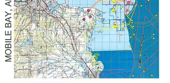
26
27 NATURAL GAS PLATFORMS There are a total of eight natural gas platforms located within the conditionally approved harvesting waters of Alabama. Six are located in Area I (on map: #1, #5, #6, #7, #8 and #9). There are no platforms in Area II, and two platforms in Area III (on map: #3 and #4). AREA I The North Dauphin Island Platform (#1) was de-manned in April of The platform is now used only as a metering station for gas storage fields. The unmanned Goose Bayou Field Platform (#2) was removed by Legacy in 2005 and moved to Area III, Saxon Bay Field (#3). The only manned platform is the Exxon/Mobil A/A Aux Platform for the Mary Ann Field, east of Billy Goat Hole channel (#5). There is zero discharge. All rainwater and waste are pipelined ashore and injected into the ground via a well. The remaining four wells have been removed and capped off. AREA II AREA III None of the platforms or wells is located near commercial quantities of shellfish. There are no natural gas platforms in the study area. There are two natural gas platforms located in Area III (#3 and #4). The Goose Bayou Field Platform (#2) was relocated from Area I to the Saxon Bay Field (#3). The other platform is the Exxon/Mobil 95E Platform in Mary Ann Field (#4). Both platforms are unmanned with zero waste discharge. The platforms are permitted to discharge rainwater runoff. Neither platform is located near any commercial quantities of shellfish. 23

28 IV.A. BACTERIOLOGICAL WATER QUALITY AREA I There are seven (7) bacteriological water quality sampling stations in Area I. The number and location of sampling stations were established based on the locations of actual or potential pollution sources, freshwater drainage, shellfish classification boundary lines, and landmarks. The location of sampling stations is illustrated in the map of Area I below and in the following table. The locations of the 7 sampling stations used to develop the current classification are: Station Latitude Longitude Common Name/Location Current Classification ' ' Cedar Point Conditionally Approved 119A ' ' North of Intercoastal WW Conditionally Approved ' ' South Side Ship Cannel/East of CP Conditionally Approved 123A ' ' Dauphin Island Bay North End Conditionally Approved ' ' NE of Heron Bay/S of AL Port Conditionally Approved ' ' East-SE of East Fowl River Conditionally Approved ' ' Heron Bay Conditionally Approved 24
29 IV. A. BACTERIOLOGICAL DATA ANALYSIS AREA I Results of water sample analysis from each water sampling station must meet NSSP Model Ordinance requirements for the indicator bacteria fecal coliform. The acceptable level of fecal coliform in shellfish growing area waters in open status that are impacted by non-point pollution sources is the most probable number (MPN), 14 fecal coliforms per 100 milliliters (14 FC/100 ml) with not more than 10% of the samples exceeding 43 FC/100 ml MPN. ADPH uses the Adverse Pollution Condition Standard for bacteriological sample collection. Samples are collected during conditions when fecal coliforms may be elevated due to high river stage and/or recent rainfall. At least thirty (30) water samples from each sampling station are required to classify a shellfish growing area. Thereafter, five (5) bacteriological water quality samples must be collected annually at each established sampling station in a Conditionally Approved area. Each annual reevaluation of the growing area s classification status must include an analysis of at least the previous fifteen (15) water sample results from each sampling station. For this Comprehensive Survey, ADPH analyzed the last thirty (30) samples collected at each station except for stations 125 and 126. Stations 125 and 126 were added in the past three to four years at FDA s recommendation, and ADPH has not yet collected 30 samples at these two stations. Twenty-three samples were analyzed for Station 125 and fifteen samples were analyzed for Station 126. The results of the fecal coliform analyses for each station are found in the Mobile Bay Bacteriological Sample Results Area I section of this survey report. Five (5) water samples were collected from each sampling station in Area I during calendar year All established water quality sampling station results in Area I met the NSSP Model Ordinance water quality requirements. ANALYSIS CONFIRMING THE CONDITIONAL MANAGEMENT PLAN ESTABLISHED FOR GROWING AREA I FDA Regional Shellfish Specialist, John Veasey, performed a correlation and regression analysis using Alabama s Area I sample data, US ACOE s Mobile River stage records, and NOAA s Mobile Regional Airport rainfall accumulation records. Significant coefficients representing rises in fecal coliform levels positively associated the elevations with both local rainfall and river stages. The correlations between log fecal coliforms and rainfall were slightly higher than the correlations between log fecal coliforms and river stages. This is logical since the samples utilized for this study were taken during times when the river stage was below or at 8 feet the trigger point for closure. It was noted through other comparisons that samples collected during closed status, even though the river stage was below 8 feet, had higher fecal counts, rainfall amounts, and river stages than fecal counts observed in samples taken during open status. The analysis indicated that ADPH s river stage management criteria are effective in managing Area I s growing waters. The correlations between river stage and fecal coliform levels were minimal. While stronger correlations existed between rainfall and fecal coliforms, they too were minimal and likely addressed by ADPH s river stage management plan. No failure to meet the NSSP Model Ordinance fecal coliform requirements at each station has occurred since ADPH implemented its current management plan. (appendix: Table IV-1) 25
National Shellfish Sanitation Program
 US FDA/CFSAN & ISSC - Model Ordinance IV. Shellstock Growing Areas; National Sh... Page 1 of 21 National Shellfish Sanitation Program Guide for the Control of Molluscan Shellfish 2007 Section II. Model
Harmful Algal Blooms
 Harmful Algal Blooms Public Health Responsibilities and Needs Prepared by Carol Dorsey Alabama Department of Public Health Mobile Division Laboratory Public Health Responsibilities Adequate communication
Proposal No Proposal for Task Force Consideration at the ISSC 2017 Biennial Meeting
 Proposal for Task Force Consideration at the ISSC 2017 Biennial Meeting Submitter ISSC Male-Specific Coliphage Committee Affiliation Interstate Shellfish Sanitation Conference Address Line 1 209 Dawson
Interstate Shellfish Sanitation Conference ANALYSIS CLASSIFIED SHELLFISH WATERS
 Interstate Shellfish Sanitation Conference ANALYSIS CLASSIFIED SHELLFISH WATERS 1985-2005 September 2006 Amended March 2007 209-2 Dawson Road Columbia, South Carolina 29223 803-788-7559 http://www.issc.org
Shellfish Sanitation and Recreational Water Quality Section. N.C. Division of Marine Fisheries Dept. of Environment and Natural Resources
 Shellfish Sanitation and Recreational Water Quality Section N.C. Division of Marine Fisheries Dept. of Environment and Natural Resources Shellfish Sanitation Program Started in 1925 following outbreaks
Water quality monitoring and fecal coliform standard. Alex Manderson Food Safety and Animal Health Program Oregon Department of Agriculture
 Water quality monitoring and fecal coliform standard Alex Manderson Food Safety and Animal Health Program Oregon Department of Agriculture A Cooperative Program Four components to help keep contaminated
Parlee Beach Water Quality Summary
 Parlee Beach Water Quality Summary Introduction This document presents a summary of the report of the Steering Committee for the Parlee Beach Water Quality project. The Committee was comprised of representatives
Little Cypress Bayou Special Study - Subwatershed 1.10
 - Subwatershed 1.1 Sabine River Authority of Texas August 31, 21 Prepared in Cooperation with the Texas Natural Resource Conservation Commission Under the Authorization of the Texas Clean Rivers Act Table
Report of Findings from the March 7 13, 2014 Study Period. FDA Technical Assistance and Training Project
 Evaluating the Dilution of Wastewater Treatment Plant Effluent, Treatment Efficiency, and Potential Microbial Impacts on Shellfish Growing Areas in Bayou La Batre, AL Report of Findings from the March
UPPER HOOD CANAL WATERSHED
 UPPER HOOD CANAL WATERSHED 2014 Water Quality Monitoring Report Kitsap Public Health District 1 2 UPPER HOOD CANAL WATERSHED The Upper Hood Canal (UHC) watershed, most of which is designated as Extraordinary
HORSESHOE LAKE WATER QUALITY IMPROVEMENT PROJECT FINAL REPORT
 KITSAP COUNTY HEALTH DISTRICT ENVIRONMENTAL HEALTH DIVISION POLLUTION IDENTIFICATION AND CORRECTION PROGRAM HORSESHOE LAKE WATER QUALITY IMPROVEMENT PROJECT FINAL REPORT By Kimberly Jones Environmental
Mobile Bay National Estuary Program Protecting Alabama s Most Valuable Resource
 Mobile Bay National Estuary Program Protecting Alabama s Most Valuable Resource Roberta Swann, Director Mobile Bay National Estuary Program March 21, 2018 Regional Response Team The Mobile Bay Watershed
Jenifer Yeadon, DA/BA Environmental Analyst I Department of Agriculture, Bureau of Aquaculture
 Jenifer Yeadon, DA/BA Environmental Analyst I Department of Agriculture, Bureau of Aquaculture Overview Who we are What we do Why we do what we do Who we are U.S. Department of Health and Human Services
One Health Forum. North Carolina Oil Spill Response, Recovery and Health Effects. July 29, 2010
 One Health Forum North Carolina Oil Spill Response, Recovery and Health Effects July 29, 2010 Oil Spill Animal Health Effects Shellfish Sanitation & Recreational Water Quality Section Division of Environmental
SCOPE OF WORK (Last amendment 9/18/08) Update: Signed agreement in hand Work to proceed March 15, 2009 June 30, 2010
 Update: Signed agreement in hand Work to proceed March 15, 2009 June 30, 2010") SCOPE OF WORK (Last amendment 9/18/08) Update: Signed agreement in hand Work to proceed March 15, 2009 June 30, 2010 TITLE: IDENTIFICATION OF ILLICIT DISCHARGES TO STORM DRAIN SYSTEM PROBLEM/NEED: The
SCOPE OF WORK (Last amendment 9/18/08) Update: Signed agreement in hand Work to proceed March 15, 2009 June 30, 2010 TITLE: IDENTIFICATION OF ILLICIT DISCHARGES TO STORM DRAIN SYSTEM PROBLEM/NEED: The
UPPER HOOD CANAL WATERSHED
 UPPER HOOD CANAL WATERSHED 2017 Water Quality Monitoring Report Kitsap Public Health District 11-1 11-2 Upper Hood Canal 2017 2017 WATER QUALITY SUMMARY The Upper Hood Canal (UHC) watershed, most of which
Canadian Shellfish Sanitation Program (CSSP) Overview of Classification of Shellfish Areas
 Overview of Classification of Shellfish Areas") Canadian Shellfish Sanitation Program (CSSP) Overview of Classification of Shellfish Areas Walter Hajen Marine Water Quality Monitoring- Pacific Science and Technology Branch Environment Canada September
Canadian Shellfish Sanitation Program (CSSP) Overview of Classification of Shellfish Areas Walter Hajen Marine Water Quality Monitoring- Pacific Science and Technology Branch Environment Canada September
NEWPORT BAY FECAL COLIFORM TMDL
 NEWPORT BAY FECAL COLIFORM TMDL 2017 ANNUAL DATA REPORT SEPTEMBER 1, 2017 Prepared for: Santa Ana Regional Water Quality Control Board to fulfill requirements of the TMDL for Fecal Coliform in Newport
NEWPORT BAY FECAL COLIFORM TMDL
 NEWPORT BAY FECAL COLIFORM TMDL 2016 ANNUAL DATA REPORT SEPTEMBER 1, 2016 Prepared for: Santa Ana Regional Water Quality Control Board to fulfill requirements of the TMDL for Fecal Coliform in Newport
(1)(A)Inventory of the following existing natural resources on the USFSP Campus or within the context area adjacent to the University.
(A)Inventory of the following existing natural resources on the USFSP Campus or within the context area adjacent to the University.") 13. 6C-21.208 CONSERVATION ELEMENT Information Sources George F. Young, Interview notes, June 2002 Sasaki Associates, Inc., interview notes, April, 2000 Interviews between DRMP Staff and USF Staff, May,
13. 6C-21.208 CONSERVATION ELEMENT Information Sources George F. Young, Interview notes, June 2002 Sasaki Associates, Inc., interview notes, April, 2000 Interviews between DRMP Staff and USF Staff, May,
2017 Water Quality Year in Review
 Lake Pontchartrain Basin Foundation Water Quality Program Pontchartrain Basin Sampling Program How Clean is Lake Pontchartrain s Water? 2017 Water Quality Year-in-Review In 2017, LPBF Water Quality Program
Livestock feces. Combined sewer overflows. Failing septic systems
 SECTION TWO Pathogen Pollution Livestock feces Wildlife feces Overboard discharges Runoff from impervious surfaces Pet feces Combined sewer overflows Bird droppings Vessel sewage discharges Failing septic
GIS as a Tool for Assisting TMDL Development
 GIS as a Tool for Assisting TMDL Development by Reem Zoun Jon Goodall Tim Whiteaker David Maidment, Ph.D. Center for Research in Water Resources University of Texas at Austin July 10, 2003 Outline Overview
Regional Approaches to Resiliency
 Regional Approaches to Resiliency Addressing the Impacts of Sea Level Rise COJ Environmental Symposium September 9, 2016 Danielle H. Irwin, PWS, LEED AP Globally, the sea is expected to rise 1 4 by 2100;
Ocean Pollution. Ocean Pollution
 Ocean Pollution Ocean Pollution Some scientists believe that it is safer to dump sewage sludge into the deep ocean because it has the ability to dilute, disperse, and degrade large amounts of pollutants
Long Island s. Environmental Issues. Environmental Issues. Environmental Setting. Environmental Setting. Suburbia and the Environment
 Environmental Issues Long Island s Environmental Issues Copyright 2011 AFG 1 agricultural land air pollution aquifers automobile barrier islands biozones fisheries groundwater recharge invasive species
National Shellfish Sanitation Program
 Page 1 of 6 National Shellfish Sanitation Program Guide for the Control of Molluscan Shellfish 2007 Section IV. Guidance Documents Chapter II. Growing Areas Guide Contents.01 Total Coliform Standards @.02
Newport Bay Water Quality Programs and Projects
 Newport Bay Water Quality Programs and Projects City of Newport Beach/UCI Water Quality Meeting November 9, 2017 David Webb 1 Director of Public Works Newport Beach Statistics Newport Bay Watershed Partnership
New York - New Jersey Harbor Estuary Program
 New York - New Jersey Harbor Estuary Program The Status of Shellfish Beds in the NY-NJ Harbor Estuary Final: November 26, 2002 By Cathy Yuhas, NJ Sea Grant College Extension Program/NY-NJ Harbor Estuary
OCEAN POLLUTION. Pollution of coastal waters near heavily populated areas is a serious problem.
 Ocean Pollution Ocean Pollution Some scientists believe that it is safer to dump sewage sludge into the deep ocean because it has the ability to dilute, disperse, and degrade large amounts of pollutants
U.S. Army Corps of Engineers Mobile District
 U.S. Army Corps of Engineers Mobile District General Permit for Living Shorelines in Alabama Sandy P. Gibson Regulatory Specialist, Coastal Alabama Regulatory Division, Mobile District US Army Corps of
April 20, 2010 Explosion aboard Deepwater Horizon 11 lives lost, 17 injured April 22, 2010 Deepwater Horizon sinks into Gulf of Mexico April 28, 2010
 April 20, 2010 Explosion aboard Deepwater Horizon 11 lives lost, 17 injured April 22, 2010 Deepwater Horizon sinks into Gulf of Mexico April 28, 2010 BP named as the Responsible Party by US Coast Guard
COLVOS PASSAGE YUKON HARBOR WATERSHED
 COLVOS PASSAGE YUKON HARBOR WATERSHED 2014 Water Quality Monitoring Report Kitsap Public Health District 1 2 COLVOS PASSAGE / YUKON HARBOR WATERSHED The Colvos Passage / Yukon Harbor (CP/YH) watershed,
Section III. Public Health Reasons and Explanations Page 1 of 47
 National Shellfish Sanitation Program 2009 NSSP Guide for the Control of Molluscan Shellfish Section III. Public Health Reasons and Explanations Page 1 of 47 Introduction Oysters, clams, and mussels are
National Shellfish Sanitation Program. Michael Antee, MS, RS AFDO Conference Sunday, June 26, 2016
 National Shellfish Sanitation Program Michael Antee, MS, RS AFDO Conference Sunday, June 26, 2016 1 Presentation Objectives National Shellfish Sanitation Program (NSSP) Imported shellfish control measures
REAPPRAISAL OF SHELLFISH GROWING AREA NE-4, THE SHARK RIVER
 New Jersey Department of Environmental Protection Land Use Management Post Office Box 409, Trenton Water Monitoring Project Water Monitoring and Standards Leslie J. McGeorge, Administrator November 2004
Achieving the Philosophy of GOMA Through MsCIP
 Achieving the Philosophy of GOMA Through MsCIP 4 th National Conference on Ecosystem Restoration August 3, 2011 The Spirit of Cooperation Integrating Partnerships for Sustainable Ecosystem Restoration
SECTION 404(b)(1) EVALUATION REPORT FOR THE FOR THE OPERATIONS AND MAINTENANCE OF THE FEDERALLY AUTHORIZED BILOXI HARBOR NAVIGATION PROJECT OTT BAYOU
(1) EVALUATION REPORT FOR THE FOR THE OPERATIONS AND MAINTENANCE OF THE FEDERALLY AUTHORIZED BILOXI HARBOR NAVIGATION PROJECT OTT BAYOU") SECTION 404(b)(1) EVALUATION REPORT FOR THE FOR THE OPERATIONS AND MAINTENANCE OF THE FEDERALLY AUTHORIZED BILOXI HARBOR NAVIGATION PROJECT OTT BAYOU HARRISON COUNTY, MISSISSIPPI I. PROJECT DESCRIPTION:
SECTION 404(b)(1) EVALUATION REPORT FOR THE FOR THE OPERATIONS AND MAINTENANCE OF THE FEDERALLY AUTHORIZED BILOXI HARBOR NAVIGATION PROJECT OTT BAYOU HARRISON COUNTY, MISSISSIPPI I. PROJECT DESCRIPTION:
Morro Bay National Estuary Program s Implementation Effectiveness Program For the Morro Bay Watershed. Stormwater Monitoring Report 2015
 Morro Bay National Estuary Program s Implementation Effectiveness Program For the Morro Bay Watershed Stormwater Monitoring Report 215 Loan Agreement Number 12-81-55 Task 3.4 Submitted by Morro Bay National
Beaches and Bacteria. Issuing a Beach Advisory or Closure
 SCIENCE BEHIND THE NEWS Beaches and Bacteria Bacteria Keep Newport News Beach Closed, Newport News Daily Press, June 2, 2004. Beach Closed Again, Fredericksburg Free Lance-Star, June 25, 2004. Norfolk
Animal Products (Specifications for Bivalve Molluscan Shellfish) Notice 2006
 Notice 2006") Animal Products (Specifications for Bivalve Molluscan Shellfish) Notice 2006 Under sections 40 and 167(1)(g) of the Animal Products Act 1999, I, Tim Knox Director New Zealand Standards issue this Notice
Animal Products (Specifications for Bivalve Molluscan Shellfish) Notice 2006 Under sections 40 and 167(1)(g) of the Animal Products Act 1999, I, Tim Knox Director New Zealand Standards issue this Notice
WOLF CREEK BACTERIAL IMPACT ON MAUMEE BAY STATE PARK BEACH
 WOLF CREEK BACTERIAL IMPACT ON MAUMEE BAY STATE PARK BEACH SUMMARY REPORT JUNE 2003 WOLF CREEK BACTERIAL IMPACT ON MAUMEE BAY STATE PARK BEACH SUMMARY REPORT JUNE 2003 Conducted by University of Toledo
BACTERIOLOGICAL WATER QUALITY IN THE BAY OF QUINTE
 BACTERIOLOGICAL WATER QUALITY IN THE BAY OF QUINTE May 1984 Ministry of the Environment The Honourable Andrew S. Brandt Minister Brock A. Smith Deputy Minister Copyright Provisions and Restrictions on
Vibrio parahaemolyticus Control Plan
 Vibrio parahaemolyticus Control Plan June 1 August 31, 2017 New Jersey Department of Environmental Protection Division of Water Monitoring and Standards / Division of Fish & Wildlife and New Jersey Department
Full List of Submitted Questions: Harmful Algal Blooms and California Fisheries
 Full List of Submitted Questions: Harmful Algal Blooms and California Fisheries California Ocean Science Trust, July 2016 In response to the 2015-2016 harmful algal bloom (HAB) and subsequent California
National Shellfish Sanitation Program 2009 NSSP Guide for the Control of Molluscan Shellfish. Section I. Definitions Page 1 of 7. Purpose.
 National Shellfish Sanitation Program 2009 NSSP Guide for the Control of Molluscan Shellfish Section I. Definitions Page 1 of 7 Purpose. This Ordinance established the minimum requirements necessary to
State of Florida Department of Community Affairs Areas of Critical State Concern Implementation Status Report Apalachicola Bay Area
 State of Florida Department of Community Affairs Areas of Critical State Concern Implementation Status Report Apalachicola Bay Area Thaddeus L. Cohen, AIA Secretary November 2006 CONTENTS Part 1 - Summary
Kitsap County Health District Water Quality Program Enetai Creek Pollution Identification and Correction Project December 15, 2009
 Summary Kitsap County Health District Water Quality Program Enetai Creek Pollution Identification and Correction Project December 15, 2009 Enetai Creek, formerly known as Dee Creek, is polluted with fecal
City of Fairmont Storm Water Pollution Prevention Plan (SWPPP) January 23, 2017
 January 23, 2017") City of Fairmont Storm Water Pollution Prevention Plan (SWPPP) January 23, 2017 Why is Water Quality Important? Water has always been important to Minnesota and is a key part of our history, culture, economy
City of Fairmont Storm Water Pollution Prevention Plan (SWPPP) January 23, 2017 Why is Water Quality Important? Water has always been important to Minnesota and is a key part of our history, culture, economy
Environmental Check List Georgia Environmental Policy Act
 Environmental Check List Georgia Environmental Policy Act Project No. : Project Name: GEORGIA IS AREA AFFECTED? IF AFFECTED, HOW SEVERELY? AREA/CATEGORY NO YES UNKNOWN MINOR MEDIAN MAJOR UNKNOWN 1. Wetlands
Draft Bacteria Total Maximum Daily Load Action Plan
 Draft Bacteria Total Maximum Daily Load Action Plan Public Works Department VSMP MS4 Permit # VA0088676 DRAFT June 12, 2018 Draft Bacteria Total Maximum Daily Load Action Plan (Permit VA0088676) Table
Henderson Watershed WRIA 13. Chapter Includes: Tanglewilde Stormwater Outfall Woodard Creek Woodland Creek
 Henderson Watershed WRIA 13 Chapter Includes: Tanglewilde Stormwater Outfall Woodard Creek Woodland Creek 146 Tanglewilde Stormwater Outfall PART OF HENDERSON WATERSHED PRIMARY LAND USES: Urban residential
TREASURE COAST REGIONAL PLANNING COUNCIL M E M O R A N D U M. To: Council Members AGENDA ITEM 3E
 TREASURE COAST REGIONAL PLANNING COUNCIL M E M O R A N D U M To: Council Members AGENDA ITEM 3E From: Date: Subject: Staff May 19, 2017 Council Meeting Local Government Comprehensive Plan Review Draft
Jacksonville City Council Candidate Survey 2019
 Jacksonville City Council Candidate Survey 2019 Threats to the St. Johns River s Health The State of the River Report for the Lower St. Johns River Basin has scientifically tracked and assessed key health
TMDL Implementation Plan for Escherichia coli (E. coli) Eaton County, MI. NPDES MS4 Permit No. MI
 Eaton County, MI. NPDES MS4 Permit No. MI") P a g e 1 TMDL Implementation Plan for Escherichia coli () Eaton County, MI NPDES MS4 Permit No. MI0059986 I. Introduction The Escherichia coli () Total Maximum Daily Load (TMDL) has been established for
P a g e 1 TMDL Implementation Plan for Escherichia coli () Eaton County, MI NPDES MS4 Permit No. MI0059986 I. Introduction The Escherichia coli () Total Maximum Daily Load (TMDL) has been established for
«225 «146. ^_ Texas Stream Team. !. Monitoring Station. "/ USGS Flow Station # Wastewater Outfall. Location Map. Morgan's Point. La Porte.
 95 5'0"W UPPER CEDAR GALVESTON BAYOU TIDAL BAY - - SEGMENT 0901 2421 95 0'0"W 94 55'0"W 94 50'0"W 29 45'0"N 29 45'0"N Trinity Bay «225 Tabbs Bay Location Map 29 40'0"N SPENCER HWY Big Island Slough SENS
GULF OF MEXICO - SEGMENT 2501
 GULF OF MEXICO - SEGMENT 2501 GULF OF MEXICO - SEGMENT 2501 LAND COVER BACTERIA CHLOROPHYLL A Impairment Concern No Impairments or Concerns GULF OF MEXICO - SEGMENT 2501 OTHER IMPAIRMENTS Bays & Estuaries
Impacts of Rainfall Events on Water Quality in the Houston Metro Area
 Impacts of Rainfall Events on Water Quality in the Houston Metro Area Hanadi Rifai and Anuradha Desai Civil and Environmental Engineering University of Houston, Houston, TX Acknowledgments TCEQ EPA Houston
Pamela Reitsma Environmental Scientist Narragansett Bay Commission
 Pamela Reitsma Environmental Scientist Narragansett Bay Commission Narragansett Bay Commission Narragansett Bay Commission (NBC) is a quasi-state agency which oversees the two largest WWTFs in Rhode Island:
REAPPRAISAL OF SHELLFISH GROWING AREA SE-7 SUNSET LAKE TO CAPE MAY HARBOR
 New Jersey Department of Environmental Protection Land Use Management Post Office Box 409, Trenton Water Monitoring Project Water Monitoring and Standards Leslie J. McGeorge, Administrator June 2005 REAPPRAISAL
Rodney L. Morris, Alan J. Mearns, and Juhee Kim 1 VIRUSES AND BACTERIA IN COASTAL WATERS AND SHELLFISH
 Rodney L. Morris, Alan J. Mearns, and Juhee Kim 1 VIRUSES AND BACTERIA IN COASTAL WATERS AND SHELLFISH The fate of viruses and pathogens discharged into the ocean in municipal effluent is not known for
STORMCON 2017 PAPER AHERN_R12
 STORMCON 2017 PAPER AHERN_R12 WHAT HAPPENS WHEN STORMWATER DISCHARGERS ARE CAUSING BUT NOT THE SOURCE OF BACTERIA VIOLATIONS Daniel Ahern P.E.,BCEE, National Stormwater Center, Beaufort SC ABSTRACT Problems
13 Official control monitoring programmes for live bivalve molluscs legislative and regulatory approaches: New Zealand
 13 Official control monitoring programmes for live bivalve molluscs legislative and regulatory approaches: New Zealand P. Busby This chapter should be read in conjunction with chapters 10, 11, 12 and 14.
PORT GAMBLE BAY/GAMBLEWOOD SANITARY SURVEY PROJECT FINAL REPORT
 PORT GAMBLE BAY/GAMBLEWOOD SANITARY SURVEY PROJECT FINAL REPORT 1.0 INTRODUCTION The Bremerton- s Sanitary Survey Program s 1995-96 Priority Area Work List rated the Port Gamble Bay/Gamblewood area most
Liberty Bay Marina Study 2010
 Liberty Bay Marina Study 2010 Abstract The purpose for the Liberty Bay Marina study was to assess the impact to water quality from untreated sewage discharges that may occur from transient and permanently
Prioritizing Target Watersheds for Action Project Implementation Committee Meeting May 3, 2018
 Prioritizing Target Watersheds for Action Project Implementation Committee Meeting May 3, 2018 Evaluation Criteria 1. Priority Restoration Watershed 2. Priority Conservation Watershed 3. Priority Freshwater
Background. Oso Watershed Land Uses
 Monitoring and Modeling of the Oso Creek and Oso Bay Watershed, Texas for a Bacteria TMDL Background Oso Creek and Oso Bay were identified as impaired segments in the 24 Texas Water Quality Inventory and
Managing On-Site Wastewater Disposal Systems
 Managing On-Site Wastewater Disposal Systems Problem In the Buzzards Bay drainage basin, 43% of the population, or more than 100,000 people, use on-site wastewater disposal systems. Moreover, most of the
Surface Water Improvement and Management (SWIM) Plan Development
 Plan Development") Surface Water Improvement and Management (SWIM) Plan Development Bay Area Resource Council TAC Paul Thorpe Chief, Bureau of Environmental May 17, 2017 and Resource Planning May 17, 2017 Surface Water Improvement
Surface Water Improvement and Management (SWIM) Plan Development Bay Area Resource Council TAC Paul Thorpe Chief, Bureau of Environmental May 17, 2017 and Resource Planning May 17, 2017 Surface Water Improvement
Overview of Drinking Water Regulations
 Overview of Drinking Water Regulations REGULATIONS William (Bill) Sullivan, Sanitary Engineer 3 Connecticut Department of Public Health Enforcement & Compliance Unit Purpose and Authority The Regulations
CRYSTAL LAKE FLOODING STUDY EXECUTIVE SUMMARY
 Project #08223 CRYSTAL LAKE FLOODING STUDY EXECUTIVE SUMMARY PREPARED FOR: City of Crystal Lake 100 West Woodstock Street Crystal Lake, Illinois 60014 FEBRUARY 11, 2009 26575 W. COMMERCE DRIVE, SUITE 601,
Hazard Analysis Worksheet
 Chapter 4: Pathogens From the Harvest Area (A Biological Hazard) Hazard Analysis Worksheet STEP #10: UNDERST THE POTENTIAL HAZARD. Pathogens in molluscan shellfish Pathogens found in waters from which
INFRASTRUCTURE ELEMENT
 Goals, Objectives and Policies INFRASTRUCTURE ELEMENT SANITARY SEWER GOAL 4.A.1.: PROVIDE ADEQUATE CENTRAL SANITARY SEWAGE FACILITIES FOR RESIDENTIAL AND NON-RESIDENTIAL DEVELOPMENT AND REDEVELOPMENT IN
Lake Madeline Bacteria Study Final Report
 Lake Madeline Bacteria Study Final Report November 11, 2006 Dr. George Guillen and Susan Moore University of Houston Clear Lake Environmental Institute of Houston EIH Technical Report 2-06 Funded by and
Business Resources Committee 2 nd Quarter Meeting June 26 th, 2018 International Trade Center
 Business Resources Committee 2 nd Quarter Meeting June 26 th, 2018 International Trade Center Meeting Agenda Welcome and Introductions: Co-chairs: Jenifer Denson & Darrelyn Dunmore Litter Gitter Update
Arkansas Department of Environmental Quality NPDES PERMIT APPLICATION FORM 1
 Arkansas Department of Environmental Quality NPDES PERMIT APPLICATION FORM 1 INSTRUCTIONS: 1. This form should be typed or printed in ink. If insufficient space is available to address any item, please
Tackling Non-point Source Water Pollution in British Columbia
 Water Quality Clean Water Tackling Non-point Source Water Pollution in British Columbia Our well-being depends on sustainable supplies of clean water for our physical health and for a healthy environment
Atlantic Coast of NY, East Rockaway Inlet to Rockaway Inlet and Jamaica Bay APPENDIX N COASTAL ZONE MANAGEMENT
 Atlantic Coast of NY, East Rockaway Inlet to Rockaway Inlet and Jamaica Bay APPENDIX N COASTAL ZONE MANAGEMENT Hurricane Sandy General Reevaluation Report August 2016 New York (and New York City Local
PUTNAM COUNTY COMPREHENSIVE PLAN EXHIBIT DD INFRASTRUCTURE ELEMENT
 COMPREHENSIVE PLAN EXHIBIT DD D. Infrastructure Element (Sanitary Sewer, Potable Water, Solid Waste, Drainage and Natural Groundwater Aquifer Recharge) Goals, Objectives and Policies GOAL D.1: Putnam County
Mobile Bay National Estuary Program. Government Networks Committee November 17, 2016 Original Oyster House, Spanish Fort, AL
 Mobile Bay National Estuary Program Government Networks Committee November 17, 2016 Original Oyster House, Spanish Fort, AL Welcome & Approval of Minutes Merceria Ludgood, Mobile County Commission Charles
Wastewater Flow Monitoring Services
 Wastewater Flow Monitoring Services For San Gabriel, CA July 13, 2015 through July 21, 2015 Revised October 9, 2015 Leaders in Sewer Flow Monitoring Services 601 N. Parkcenter Dr., Suite 209 Santa Ana,
Local Solutions to Our Water Quality Crisis
 Local Solutions to Our Water Quality Crisis Florida SouthWestern State College Lifelong Learning Institute January 2019 Dr. Coty Keller Why the estuary is so important to our economy and lifestyles What
Citizen Science Monitoring for Pathogens on Staten Island A FINAL REPORT FOR THE NY-NJ HARBOR AND ESTURARY PROGRAM
 Citizen Science Monitoring for Pathogens on Staten Island A FINAL REPORT FOR THE NY-NJ HARBOR AND ESTURARY PROGRAM Prepared by Paul L. Sieswerda, President, Gotham Whale September 2017 Introduction: Gotham
RULES OF THE TENNESSEE DEPARTMENT OF ENVIRONMENT AND CONSERVATION WATER RESOURCES DIVISION CHAPTER PRIORITY RANKING SYSTEM
 RULES OF THE TENNESSEE DEPARTMENT OF ENVIRONMENT AND CONSERVATION WATER RESOURCES DIVISION CHAPTER 0400-46-01 PRIORITY RANKING SYSTEM TABLE OF CONTENTS 0400-46-01-.01 Priority Ranking System: General 0400-46-01-.03
MANAGEMENT OF PATHOGENIC CONTAMINATION
 MANAGEMENT OF PATHOGENIC CONTAMINATION PROBLEMS Beach closures Shellfish bed closures VISION GOALS OBJECTIVES SOURCES Municipal discharges Combined sewer overflows Storm water Vessel discharges Other non-point
5.5 NAVIGABLE WATERWAYS AND COASTAL ZONE
 5.5 NAVIGABLE WATERWAYS AND COASTAL ZONE This section discusses the effect of the Proposed Action on navigable waterways, and the Proposed Action s consistency with coastal zone policies. 5.5.1 Navigable
PUBLIC NOTICE NO. FP13-AB03-05 August 30, 2013 CESAM-PD-EC JOINT PUBLIC NOTICE
 DEPARTMENT OF THE ARMY MOBILE DISTRICT, CORPS OF ENGINEERS P.O. BOX 2288 MOBILE, ALABAMA 36628-0001 REPLY TO ATTENTION OF: JOINT PUBLIC NOTICE U. S. ARMY CORPS OF ENGINEERS, MOBILE DISTRICT AND FLORIDA
3. PUBLIC FACILITIES ELEMENT
 3. PUBLIC FACILITIES ELEMENT A. Purpose This Element is intended to identify essential public facilities, buildings, and services and to describe policies and programs that will ensure that the existing
TABLE OF CONTENTS 4.17 UTILITIES AND SERVICE SYSTEMS...
 TABLE OF CONTENTS 4.17 UTILITIES AND SERVICE SYSTEMS... 4.17-1 4.17.0 Introduction... 4.17-1 4.17.1 Methodology... 4.17-2 4.17.2 Existing Conditions... 4.17-2 4.17.3 Impacts... 4.17-4 4.17.4 Applicant-Proposed
SINCLAIR INLET WATERSHED
 SINCLAIR INLET WATERSHED 2015 Water Quality Monitoring Report Kitsap Public Health District SN18 2015 STREAM WATER QUALITY SUMMARY The Sinclair Inlet watershed is located in central Kitsap County. Most
EUROPEAN COMMUNITY COMMENTS ON CODEX CIRCULAR LETTER CL 2007/21-FFP
 12/12/2007 EUROPEAN COMMUNITY COMMENTS ON CODEX CIRCULAR LETTER CL 2007/21-FFP REQUESTING COMMENTS AT STEP 6 ON THE: Proposed draft Code of Practice for Fish and Fishery Products (Live and Raw Bivalve
INFLOW DESIGN FLOOD CONTROL SYSTEM PLAN PLANT GASTON GYPSUM POND ALABAMA POWER COMPANY
 INFLOW DESIGN FLOOD CONTROL SYSTEM PLAN PLANT GASTON GYPSUM POND ALABAMA POWER COMPANY Section 257.82 of EPA s regulations requires the owner or operator of an existing or new CCR surface impoundment or
Chapter 6 Regulations and Requirements
 Chapter 6 Regulations and Requirements The information in this chapter is provided to help you comply with other Tacoma and Washington State regulations, which may apply to your project, industry or business
City of Daphne, Alabama Water Quality Monitoring Plan For Phase II MS4
 City of Daphne, Alabama Water Quality Monitoring Plan For Phase II MS4 2016-2021 Permit # ALR 040039, Expiration Date: September 30, 2021 I. Introduction This document presents the City of Daphne s Stormwater
Ocean Water Quality Challenges
 Ocean Water Quality Challenges Dominic Gregorio Senior Environmental Scientist, Ocean Unit Division of Water Quality State Water Resources Control Board www.waterboards.ca.gov NPDES Permits written to
Shellfish Program Newsletter May 2012
 Maine State Library Maine State Documents Public Health - Shellfish Program Documents Marine Resources 5-2012 Shellfish Program Newsletter May 2012 Jake Van Gorder Maine Department of Marine Resources
ROUGE RIVER MONITORING FOR E. COLI TMDL IMPLEMENTATION FINAL REPORT GRANT#
 1 ROUGE RIVER MONITORING FOR E. COLI TMDL IMPLEMENTATION FINAL REPORT GRANT# 2011-0504 FUNDED BY: MICHIGAN DEPARTMENT OF ENVIRONMENTAL QUALITY CLEAN MICHIGAN INITIATIVE CLEAN WATER FUND LANSING, MI PREPARED
Fecal Coliform Pollution in Drayton Harbor through 2008
 Status and Trends Summary Fecal Coliform Pollution in Drayton Harbor through 2008 June 24, 2009 Office of Shellfish and Water Protection 2 Introduction The Washington State Department of Health (DOH) protects
City of Valdosta Land Development Regulations
 Chapter 324 Section 324-1 Environmental Planning Criteria Protection of Groundwater Recharge Areas (A) Purpose and Intent. Pursuant to O.C.G.A. 12-2-8 and the Georgia Department of Natural Resources (DNR),
Lake Madeline Bacteria Study Final Summary Report
 Lake Madeline Bacteria Study Final Summary Report November 16, 2010 Dr. George Guillen University of Houston Clear Lake Environmental Institute of Houston EIH Technical Report 2-10A Funded by and conducted