US 41 Incident Management Plan. Baraga Houghton Keweenaw Counties
|
|
|
- Brian Flowers
- 6 years ago
- Views:
Transcription


1 US 41 Incident Management Plan Baraga Houghton Keweenaw Counties From US 141/M 28 intersection in Baraga County to the terminus of US 41 near Copper Harbor September 2014 This notebook shows approved detour routes to use when emergency, nonconstruction related incidents, or severe weather conditions force the temporary closure of any segment of US 41 from the US 141/M 28 intersection in Baraga County to the terminus of US 41 near Copper Harbor. Included are narrative descriptions and maps of approved detour routes as well as interagency communications for roadway closures. Prepared by: CUPPAD Regional Commission for the Michigan Department of Transportation
2 Table of Contents EMERGENCY INCIDENT RESPONSE... 2 Purpose... 2 Traffic Control Options... 2 Detour Traffic Control Option... 3 Mobility (Moving Trunkline Traffic) Agency Responsibilities... 4 Signs and Barricades... 4 STATE TRUNKLINE CLOSURE RESPONSIBILITIES AND PROCEDURES... 5 Roadway Closure Types... 5 Immediate Emergency Closure... 5 Anticipated Emergency Closure... 6 Detour Required... 6 No Detour Required... 6 Temporary Closure with No Detour... 6 AUTHORITY... 8 State of Michigan Constitution of 1963, Sec Official Highway Closures... 8 Police Agencies... 8 INCIDENT MANAGEMENT COMMUNICATIONS FLOWCHART COMMUNICATIONS PHONE LISTING US 41 EMERGENCY CORRIDOR DETOUR PLAN... Error! Bookmark not defined. APPENDIX A MICHIGAN DEPARTMENTS OF TRANSPORTATION AND STATE POLICE PROCEDURES FOR CLOSURE OF STATE HIGHWAYS APPENDIX B LETTERS OF UNDERSTANDING
3 EMERGENCY INCIDENT RESPONSE Purpose This plan is intended for use during emergency, non construction related incidents, or severe weather conditions that exist along and are unique to the US 41 corridor in Baraga, Houghton and Keweenaw Counties between the US 141/US 41 intersection in Baraga County to the terminus of US 41 in Keweenaw County. The conditions causing the decision for closure, and the procedure used for the closure, must comply with the Procedures for Closure of State Highways dated 2006, which is included as Appendix A. An emergency condition decision must be made jointly by the Michigan State Police (MSP) and Michigan Department of Transportation (MDOT). This Incident Management Plan is the fourth in a series of five such plans for the Upper Peninsula. The purpose of the plan is to establish detour routes and traffic management strategies should it be necessary to temporarily close any portion of US 41 for an extended period of time due to an emergency. MDOT has developed Letters of Understanding to serve as agreements for detouring trunkline traffic onto approved local County and City roads. These letters have been signed by either a County Road Commission or a City and are included as part of this plan as Appendix B. Traffic Control Options The MDOT Superior Region guidelines for Incident Management Traffic Control on state trunkline routes and highways during short term and long term closures are as follows: 1. If the incident type permits a partial closure of the trunkline route or highway and sufficient room exists for movement of traffic thru the incident location, then flagging of traffic should be considered. 2. For full closure of the trunkline route or highway with duration of less than 30 minutes, the option of holding traffic in place may be considered. 3. For full closure of the trunkline route or highway with duration of less than 10 hours, the options of either an approved local municipal/county detour route, or a trunkline to trunkline detour route should be considered for detouring of traffic. The use of municipal/county approved detour routes shall be in accordance with the Incident Response Plan Document, herein. 4. For full closure of the trunkline route or highway with duration greater than 10 hours, the only option to use is a trunkline to trunkline detour route for detouring of traffic. 1
4 NOTE: All over weight and over width permitted vehicles shall be held in place during the closure time period, unless otherwise permitted by MDOT to change routes. Detour Traffic Control Option In pre selecting the detour routes outlined in this plan, primary consideration was given to the adequacy of the detour route to safely and efficiently accommodate both passenger car and truck traffic. The detour routes should require minimal police supervision, thus freeing officers to address the emergency. There may be times when traffic volumes overload the preselected detour route. Daily rushhour periods and summer weekends potentially pose particular problems. Only approved detour routes shall be used. The appropriate MDOT Service Center Traffic Engineer from the Communications Phone Listing should be notified if long term closures necessitate additional detour routes and strategies. Mobility (Moving Trunkline Traffic) The Incident Management Plan aims to have traffic moving safely and efficiently on the trunkline as soon as possible. Each emergency incident will be unique. All requirements necessary to move trunkline traffic must be considered when determining whether to hold trunkline traffic or to detour trunkline traffic onto approved local or trunkline detour routes. Primary considerations at the incident site are holding traffic or maintaining mobility with flag control. For emergency closure estimated to last less than 10 hours, the appropriate local detour route, or combination of routes depending on the location of the incident, should be used. Local road agencies shall be contacted to ensure the designated detour route is available. Emergency closures estimated to last more than 10 hours, trunkline detour routes shall be used. For full closure of the trunkline route with duration of less than 30 minutes, the option of holding traffic in place may be considered by the Incident Commander. Traffic back up must be monitored. If trunkline traffic backs up to the nearest identified detour route, traffic must be detoured. If the estimated closure time exceeds the approximate travel time of the detour route, the option of detouring trunkline traffic may be considered by the Incident Commander. 2
5 911 Agency Responsibilities All 911 agencies should document communication from the local road agencies (city, village, county, state) of the availability of the approved detour routes. Statewide Transportation Operations Center The Statewide Transportation Operations Center (STOC) is a 24/7/365 support center located in the State Transportation Building in Lansing. STOC will be available to assist Incident Commanders with Traffic Incident Management. STOC is capable of managing traffic on MDOT roadways throughout the state. The 911 Central Dispatch Center will contact STOC to handle all necessary non emergency and traffic related notifications during an incident. STOC will be responsible for disseminating real time traveler information to dynamic message signs, websites, media, schools, Mi Drive traffic data website, MDOT personnel and other agencies as requested. STOC will also handle press releases. Signs and Barricades Signs and Barricades are to be used at the discretion of the on scene officials. Dynamic Message Signs There are no Dynamic Message Signs (DMS) within the covered area of this Incident Management Plan. Portable signs may also be available upon request 3
6 STATE TRUNKLINE CLOSURE RESPONSIBILITIES AND PROCEDURES This section of the US 41 Incident Management Plan explains the responsibility for establishing a roadway closure and implementing the detour routes contained in this notebook. The following paragraphs describe the roadway closure procedures. Roadway Closure Types Roadway closures can be classified into two categories: Immediate Emergency Closure and Anticipated Emergency Closure. Immediate Emergency Closures result from situations that occur without prior notice or warning. Examples of this type of situation would be a traffic accident, vehicle over turn or breakdown, fire, toxic cargo leak, cargo spill, some immediate pavement anomaly (such as heaved pavement), structural failure including bridge, sign or sign support, or other significant failure. Anticipated closures may be scheduled in advance in response to conditions that develop over a period of time. Examples include snow/ice closures, floods, heavy rains, construction projects that require temporary closing, and other authorized closures. Immediate Emergency Closure The first police agency on the scene will report the incident to the 911 Regional Dispatch Center, identifying and acquiring initial emergency medical, fire and other needs and/or function as the Incident Commander. The portion of US 41 to be closed and the appropriate detour plan should be identified on the Index Map, Trunkline Detour Maps and Local Detour Routes. The appropriate procedures to follow and the agencies to involve are outlined in the Incident Management Communications Flowchart shown on page 10 and in the corresponding Communications Phone Listing shown on pages 11 through 13. The nearest Michigan Department of State Police Post (Calumet Post No. 87) should be notified of any state highway emergency closing. The State Police have the ultimate responsibility of closure response coordination in the absence of a locally designated coordinating unit and are responsible for coordinating emergency services that may be required by various state agencies or departments. The 911 Central Dispatch Center will contact the appropriate police agencies to arrange for the necessary additional officers to secure the incident scene, close the roadway at the pre planned detour intersection upstream/downstream from the incident to avoid trapping additional motorists, re route trapped traffic and initially direct traffic along the designated detour route. The 911 Central Dispatch Center will contact the Statewide Transportation Operations Center (STOC); the STOC will handle all necessary non emergency and traffic related notifications. The appropriate Maintenance Agency will be informed of the location and the nature of the incident, the detour route to be used, the anticipated length of time that the roadway must be 4
7 closed and the need for general assistance. The 911 Central Dispatch Center will also contact the State Police Eighth District Headquarters in Marquette. Once a roadway is closed, the 911 Central Dispatch Center will contact the STOC, who will then advise the media including television, radio and press. The STOC will also contact MDOT personnel (Communications Representative, maintenance, TSC managers, etc.), schools and any other agencies as requested by MDOT. The STOC will disseminate information to the Mi Drive traffic data website and handle press releases. The Michigan Department of Transportation Superior Region Office in Escanaba, the State Fire Marshal and Emergency Management Division of the State Police will be contacted by the Incident Commander as needed. When the incident has been cleared, the Incident Commander will make the decision to reopen the roadway after checking with the affected parties. STOC will notify the media, Mi Drive traffic data website, MDOT personnel, schools and other agencies as requested when the highway has been reopened. Anticipated Emergency Closure Anticipated closures can be classified in two ways, Detour Required and No Detour Required: Detour Required The designated Incident Commander will coordinate with law enforcement and MDOT for road closures and openings. The designated Incident Commander shall notify the 911 Central Dispatch Center. The 911 Central Dispatch Center shall notify all affected state, local and county police agencies, highway and road agencies of the anticipated closure. With the Michigan Department of Transportation representative, the appropriate detour route shall be selected. This Emergency Incident Response notebook shows the recommended detour routes. The sequence of events listed for an immediate closure will be followed except that the Incident Commander will coordinate all activities. The STOC shall handle all non emergency and traffic mobility notifications. No Detour Required For severe weather closures usually associated with snowstorms, etc., the entire general region is affected and virtually all roadways may be closed. In cases like this, no detour will be established and the primary effort by police and road agencies will be to get stranded motorists to shelter and eventually open the roadways to minimal traffic. Details of this type of operation are given in Procedures for Closure of State Trunk Line Highways dated 2006, which is included as Appendix A. Temporary Closure with No Detour Occasionally a situation will arise that will require a very short term closure of a highway and no detour is anticipated. These events are usually connected with construction, utility, or maintenance activities by MDOT or their Contract Road Agencies or its contractor. The closure is either authorized by MDOT or the road agency that is responsible for notifying the Law 5
8 Enforcement Incident Commander in the area. The closure normally occurs during light traffic volume periods in daylight hours and typically lasts from five to fifteen minutes. Allowing drivers to wait on the roadway under police control rather is less of an inconvenience than attempting to detour them. 6
9 AUTHORITY The authority for a roadway closure is provided in the following references. State of Michigan Constitution of 1963, Sec. 28 There is hereby established a state highway commission, which shall administer the state highway department and have jurisdiction and control over all state trunkline and appurtenant facilities, and such other public works of the state, as provided by law Official Highway Closures The legal authority and responsibility of the State Transportation Commission for officially closing trunklines is found in Section 497 of the Penal Code, MCLA , which authorizes the closure of highways to ensure public safety. Under statutory provisions of this authority, it is deemed that the following will provide necessary compliance with legal requirements for closing of road(s) necessitated by accidents completely blocking roadways, severe storm conditions or catastrophe: 1. A command decision by the Director, Department of State Transportation, and/or his representative, coordinated with the Department of State Police, for closing section(s) of the state highways/freeways for the safety and well being of the traveling public. 2. Providing the use of all available news media to alert and warn the public of closure(s). All terminal points of closure(s) to be designated in the news releases, with alternate route(s) by passing the closure(s) where possible. 3. All terminal points of closure(s) will be provided with necessary controls in advance of, and at the points of closure to warn and direct the public. Primary controls with law enforcement personnel will be augmented as rapidly as possible with other vehicles, signs, signals, and barricades provided from nearest available highway agency resources when required. Police Agencies The authority cited in the Michigan Vehicle Code, Section , provides that a person shall not refuse to comply with a lawful order or direction of a police officer when that officer, for public interest and safety, is guiding, directing, controlling, or regulating traffic on the highways of this state. This includes the control of traffic when conditions exist that are hazardous to the traveling public, i.e., dangerous conditions requiring immediate actions for public safety, scenes of serious accidents, severely reduced visibility, extensive damage to roadways or flooding, etc. The Fire Prevention Act, Act 207 Public Acts of 1941, Sections 29.1 to of the Michigan Compiled Laws as amended by Act 3 of the Public Acts of 1978, requires all accidents or incidents involving hazardous materials to be reported to the State Fire Marshal. Actions taken 7
10 will be determined by the State Fire Marshal in coordination with the responding fire or police department. 1. A temporary closure under police authority will be coordinated with the responsible road agency (county/state), and State Transportation officials. 2. Incidents requiring a detour of traffic from state highway system require notification to the MDOT Region Delivery Engineer or the other responsible road agency, as soon as possible, preferably prior to re routing traffic to an alternate route. 8
11 INCIDENT MANAGEMENT COMMUNICATIONS FLOWCHART State Emergency Services (Michigan Emergency Management Plan) Confirm Assess Incident By: Michigan Department of State Police Telephone: (906) Hazardous Material Fire Marshal Major Truck Motor Carrier Natural Disaster Emer. Mgmt Division Nuclear Emer. Mgmt Division National Security Emer. Mgmt Division Other State Agencies MDOT MDNR MDEQ MDARD MDCH Local Emergency Management Coordinator By: Police at scene Coordinate Required Services By: Incident Commander and 911 Dispatch Center Local Services Emergency: Medical Fire Towing Etc. Non Emergency Communications/ Traffic Mobility Notifications By: State Traffic Operations Center (STOC) Contact MDOT personnel TV Radio Schools MiDrive traffic data website Other agencies as requested by MDOT US 41 DETOUR TRAFFIC CONTROL PROCEDURES Identify appropriate US 41 segment and detour plan in this notebook for implementation. 911 dispatch will contact road agencies to ensure the designated detour route is available 9
12 COMMUNICATIONS PHONE LISTING Communications Phone Listing (to be used with Incident Management Communications Flow Chart) Entity Business Phone (906 area code unless specified) Michigan Dept. of Transportation (MDOT) Offices: Superior Region Office Escanaba Escanaba Transportation Service Center Ishpeming Transportation Service Center Crystal Falls Transportation Service Center Michigan State Police: 8 th District Headquarters Marquette MSP Traffic Safety Division 8 th District / Supervision Calumet Post No L Anse Detachment (not staffed) Dept. of Natural Resources (MDNR): Baraga Customer Service Center (Baraga, Gogebic, Houghton, Keweenaw and Ontonagon Counties) Crystal Falls Field Office (Law Enforcement) Dept. of Environmental Quality (MDEQ) District/Field Offices: U.P. District Office Marquette Baraga (Water Resources Division) Baraga County: Negaunee Regional Dispatch Office of Emergency Services Sheriff s Department Road Commission Village of Baraga Police Dept Village of L Anse
13 Communications Phone Listing (to be used with Incident Management Communications Flow Chart) Entity Business Phone (906 area code unless specified) Keweenaw Bay Indian Community Tribal Police Baraga County Memorial Hospital Copper Country Intermediate School District Arvon Township School District Baraga Area Schools L Anse Area Schools USFS Ottawa National Forest, Supervisor s Office (Ironwood) Ottawa National Forest, Kenton Ranger District Houghton County: Negaunee Regional Dispatch Emergency Measures Office Sheriff s Department Road Commission City of Houghton Police Department City of Hancock Police Department Village of Calumet Village of Copper City Village of Lake Linden Police Department Village of Laurium Police Department Village of South Range U.P. Health Systems Portage (Hancock) Aspirus Keweenaw Hospital (Laurium) Copper Country Intermediate School District Adams School District Calumet, Laurium & Keweenaw, Public Schools of Elm River Township School District Dollar Bay Tamarack City Area Schools Hancock Public School District / Emergency: Houghton Portage Township School District Lake Linden Hubbell Public School District Stanton Township Public Schools
14 Communications Phone Listing (to be used with Incident Management Communications Flow Chart) Entity Business Phone (906 area code unless specified) Keweenaw County: Negaunee Regional Dispatch Emergency Measures Offices (contracted services with Houghton County) Sheriff s Department Road Commission Village of Ahmeek Copper Country Intermediate School District Calumet, Laurium & Keweenaw, Public Schools of Grant Township Public School District
15 US 41 EMERGENCY CORRIDOR DETOUR PLAN The following US 41 Emergency Corridor Detour Plan represents an individual route plan for each detour. The corresponding detour route map follows the individual route plan. Travel times for segments of US 41 and detours are listed on the individual route plans. The total travel time variation between the US 41 route and the trunkline and local detours is also listed on the individual route plans. All travel times are approximate. 13
16
17 USE WITH PLAN ON OPPOSITE PAGE DETOUR: Trunkline I COUNTY: BARAGA FROM: US 141 TO: M 38 NORTHBOUND DETOUR: 1. Northbound traffic will turn left (west) onto US 141/M Continue straight onto M 28 to Bruce Crossing 3. Turn right (north) onto US Turn right (east) onto M 26 N 5. Turn right (east) onto M 26/M Turn right (south) onto M 38EB 7. Turn left (north) onto US 41 SOUTHBOUND DETOUR: 1. Southbound traffic turn right (west) onto M Turn left (west) onto M 26/M Turn left (south) onto M Turn left (south) onto US Turn left (east) onto M Turn right (south) onto US 41 Approximate US 41 Route Travel Time: Approximate Detour Route Travel Time: Approximate Total Variation Time: 19 minutes 1 hour 35 minutes 1 hour 26 minutes For full closure of the trunkline route with duration of less than 30 minutes, the option of holding traffic in place may be considered by the Incident Commander. Traffic back up must be monitored. If trunkline traffic backs up to the nearest identified detour route, traffic must be detoured. If the estimated closure time exceeds the approximate travel time of the detour route, the option of detouring trunkline traffic may be considered by the Incident Commander. USE WITH PLAN ON OPPOSITE PAGE
18
19 USE WITH PLAN ON OPPOSITE PAGE DETOUR: US41I 017 COUNTY: BARAGA FROM: Superior Avenue TO: M 38/Michigan Avenue NORTHBOUND DETOUR: 1. Northbound traffic will turn left (north) onto Superior Avenue 2. Turn right (east) onto M 38/Michigan Avenue 3. Turn left (north) onto US 41 SOUTHBOUND DETOUR: 1. Southbound traffic will turn right (east) onto M 38/Michigan Avenue 2. Turn left (south) onto Superior Street 3. Turn right (south) onto US 41 Approximate US 41 Route Travel Time: Approximate Detour Route Travel Time: Approximate Total Variation Time: 02 minutes 05 minutes 03 minutes For full closure of the trunkline route with duration of less than 30 minutes, the option of holding traffic in place may be considered by the Incident Commander. Traffic back up must be monitored. If trunkline traffic backs up to the nearest identified detour route, traffic must be detoured. If the estimated closure time exceeds the approximate travel time of the detour route, the option of detouring trunkline traffic may be considered by the Incident Commander. USE WITH PLAN ON OPPOSITE PAGE

20
21 USE WITH PLAN ON OPPOSITE PAGE DETOUR: Trunkline J COUNTY: BARAGA FROM: M 38 TO: M 26 NORTHBOUND DETOUR: 1. Northbound traffic will turn left (west) onto M Turn right (north) onto M 26 to Houghton 3. Continue on M 26 to US 41NB at the Portage Lake Lift Bridge SOUTHBOUND DETOUR: 1. Southbound traffic will continue on M 26 south from the City of Houghton 2. Turn left (east) onto M Turn right (south) onto US 41 in the Village of Baraga Approximate US 41 Route Travel Time: Approximate Detour Route Travel Time: Approximate Total Variation Time: 32 minutes 1 hour 15 minutes 42 minutes For full closure of the trunkline route with duration of less than 30 minutes, the option of holding traffic in place may be considered by the Incident Commander. Traffic back up must be monitored. If trunkline traffic backs up to the nearest identified detour route, traffic must be detoured. If the estimated closure time exceeds the approximate travel time of the detour route, the option of detouring trunkline traffic may be considered by the Incident Commander. USE WITH PLAN ON OPPOSITE PAGE

22
23 USE WITH PLAN ON OPPOSITE PAGE DETOUR: US41J 018 COUNTY: HOUGHTON FROM: Chassell Painesdale Road TO: Portage Lake Lift Bridge NORTHBOUND DETOUR: 1. Northbound traffic will turn left (west) onto 5 th Street/Chassell Painsdale Road 2. Turn right (north) onto Superior Street 3. Turn left (west) onto Chassell Painsdale Road 4. Turn right (north) onto M Veer left onto US 41 SOUTHBOUND DETOUR: 1. Southbound traffic will keep to right (west) onto M Turn left (east) onto Chassell Painsdale Road 3. Turn right (south) onto Superior Street 4. Turn left (east) onto Chassell Painsdale Road 5. Turn right(south) onto US 41 Approximate US 41 Route Travel Time: Approximate Detour Route Travel Time: Approximate Total Variation Time: 12 minutes 30 minutes 18 minutes For full closure of the trunkline route with duration of less than 30 minutes, the option of holding traffic in place may be considered by the Incident Commander. Traffic back up must be monitored. If trunkline traffic backs up to the nearest identified detour route, traffic must be detoured. If the estimated closure time exceeds the approximate travel time of the detour route, the option of detouring trunkline traffic may be considered by the Incident Commander. USE WITH PLAN ON OPPOSITE PAGE

24
25 USE WITH PLAN ON OPPOSITE PAGE DETOUR: US41J 019 COUNTY: HOUGHTON FROM: MacInnes Drive TO: Portage Lake Lift Bridge NORTHBOUND DETOUR: 1. Northbound traffic will turn left (south) onto MacInnes Drive 2. Keep to right (south) onto W. Sharon Avenue 3. Turn right (north) onto W. Memorial Drive/M Veer left onto US 41 SOUTHBOUND DETOUR: 1. Southbound traffic will keep to the right (west) onto M 26/W. Memorial Drive 2. Turn left (east) onto W. Sharon Avenue 3. Veer left (west) onto MacInnes Drive 4. Turn right (east) onto US 41 Approximate US 41 Route Travel Time: Approximate Detour Route Travel Time: Approximate Total Variation Time: 03 minutes 09 minutes 06 minutes For full closure of the trunkline route with duration of less than 30 minutes, the option of holding traffic in place may be considered by the Incident Commander. Traffic back up must be monitored. If trunkline traffic backs up to the nearest identified detour route, traffic must be detoured. If the estimated closure time exceeds the approximate travel time of the detour route, the option of detouring trunkline traffic may be considered by the Incident Commander. USE WITH PLAN ON OPPOSITE PAGE

26
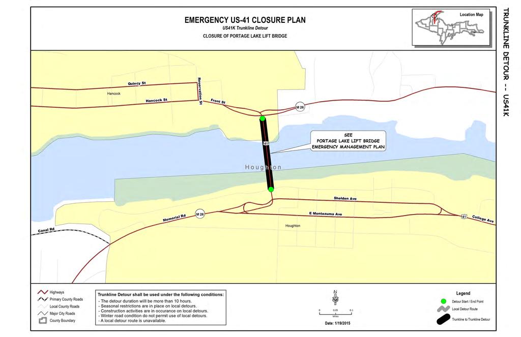
27 USE WITH PLAN ON OPPOSITE PAGE DETOUR: Trunkline K COUNTY: HOUGHTON FROM: Portage Lake Lift Bridge TO: Portage Lake Lift Bridge NORTHBOUND DETOUR: 1. Reference Portage Lake Lift Bridge Emergency Management Plan SOUTHBOUND DETOUR: 1. Reference Portage Lake Lift Bridge Emergency Management Plan For full closure of the trunkline route with duration of less than 30 minutes, the option of holding traffic in place may be considered by the Incident Commander. Traffic back up must be monitored. If trunkline traffic backs up to the nearest identified detour route, traffic must be detoured. If the estimated closure time exceeds the approximate travel time of the detour route, the option of detouring trunkline traffic may be considered by the Incident Commander. USE WITH PLAN ON OPPOSITE PAGE
28
29 USE WITH PLAN ON OPPOSITE PAGE DETOUR: Trunkline L COUNTY: HOUGHTON FROM: M 203 TO: M 203 NORTHBOUND DETOUR: 1. Northbound traffic will continue straight (west) onto M 203/Quincy Street in Hancock 2. Turn left (north) onto US 41 in Calumet SOUTHBOUND DETOUR: 1. Southbound traffic turn right (west) onto M 203/Pine Street in Calumet 2. Turn right (south) onto US 41/Lincoln Drive in the City of Hancock Approximate US 41 Route Travel Time: Approximate Detour Route Travel Time: Approximate Total Variation Time: 15 minutes 27 minutes 12 minutes For full closure of the trunkline route with duration of less than 30 minutes, the option of holding traffic in place may be considered by the Incident Commander. Traffic back up must be monitored. If trunkline traffic backs up to the nearest identified detour route, traffic must be detoured. If the estimated closure time exceeds the approximate travel time of the detour route, the option of detouring trunkline traffic may be considered by the Incident Commander. USE WITH PLAN ON OPPOSITE PAGE

30
31 USE WITH PLAN ON OPPOSITE PAGE DETOUR: US41L 020 COUNTY: HOUGHTON FROM: Reservation Street TO: White Street NORTHBOUND DETOUR: 1. Northbound traffic will continue north straight through Quincy Street intersection onto Reservation Street 2. Veer to left (north) onto White Street 3. Turn right (north) onto US 41 SOUTHBOUND DETOUR: No southbound detour for this route Approximate US 41 Route Travel Time: Approximate Detour Route Travel Time: Approximate Total Variation Time: 03 minutes 1.5 minutes 1.5 minutes For full closure of the trunkline route with duration of less than 30 minutes, the option of holding traffic in place may be considered by the Incident Commander. Traffic back up must be monitored. If trunkline traffic backs up to the nearest identified detour route, traffic must be detoured. If the estimated closure time exceeds the approximate travel time of the detour route, the option of detouring trunkline traffic may be considered by the Incident Commander. USE WITH PLAN ON OPPOSITE PAGE

32
33 USE WITH PLAN ON OPPOSITE PAGE DETOUR: Trunkline M COUNTY: HOUGHTON FROM: M 26 TO: M 26 NORTHBOUND DETOUR: 1. Northbound traffic will turn right (east) onto M 26 at north end of the Portage Lake Lift Bridge 2. Continue on M 26 N through the Villages of Lake Linden and Laurium 3. Turn right (north) onto US 41/Calumet Avenue SOUTHBOUND DETOUR: 1. Southbound traffic turn left (east) onto M 26/3 rd Street 2. Continue on M 26N through the Villages of Lake Linden and Laurium 3. Turn left (south) onto US 41 at the Portage Lake Lift Bridge Approximate US 41 Route Travel Time: Approximate Detour Route Travel Time: Approximate Total Variation Time: 15 minutes 23 minutes 08 minutes For full closure of the trunkline route with duration of less than 30 minutes, the option of holding traffic in place may be considered by the Incident Commander. Traffic back up must be monitored. If trunkline traffic backs up to the nearest identified detour route, traffic must be detoured. If the estimated closure time exceeds the approximate travel time of the detour route, the option of detouring trunkline traffic may be considered by the Incident Commander. USE WITH PLAN ON OPPOSITE PAGE

34
35 USE WITH PLAN ON OPPOSITE PAGE DETOUR: US41M 021 A, B, C, D COUNTY: HOUGHTON FROM: Scott Street TO: Reservation Street NORTHBOUND DETOUR: N/A SOUTHBOUND DETOUR: **Portions of Quincy Street/US 41N will be open to two way traffic for the duration of the closure as noted below. Extensive coordination with the City of Hancock DPW and Police Department will be necessary to control traffic, especially at the 90 degree turns at the Quincy Street/Reservation Street and Reservation Street/Front Street/Hancock Street intersections.** Southbound traffic will be rerouted via Quincy Street/US 41N as follows: 021A: Incident between Scott Street and Dakota Street 1. Turn left (north) on Scott Street 2. Turn right (east) on Quincy Street/US 41 N (Quincy Street/US 41N will be open to two way traffic between Scott Street and Dakota Street for the duration of the closure) 3. Turn right (south) on Dakota Street 4. Turn left (east) on Hancock Street/US 41 S. Approximate US 41 Route Travel Time: 15 seconds Approximate Detour Route Travel Time: 03 minutes Approximate Total Variation Time: 2.75 minutes 021B: Incident between Dakota Street and Mesnard Street 1. Turn left (north) on Dakota Street 2. Turn right (east) on Quincy Street/US 41 N (Quincy Street/US 41N will be open to two way traffic between Dakota Street and Mesnard Street for the duration of the closure) 3. Turn right (south) on Mesnard Street 4. Turn left (east) on Hancock Street/US 41 S. Approximate US 41 Route Travel Time: 15 seconds Approximate Detour Route Travel Time: 03 minutes Approximate Total Variation Time: 2.75 minutes
36 021C: Incident between Mesnard Street and Ravine Street 1. Turn left (north) on Mesnard Street 2. Turn right (east) on Quincy Street/US 41 N (Quincy Street/US 41N will be open to two way traffic between Mesnard Street and Ravine Street for the duration of the closure) 3. Turn right (south) on Ravine Street 4. Turn left (east) on Hancock Street/US 41 S. Approximate US 41 Route Travel Time: 30 seconds Approximate Detour Route Travel Time: 03 minutes Approximate Total Variation Time: 2.5 minutes 021D: Incident between Ravine Street and Reservation Street 1. Turn left (north) on Ravine Street 2. Turn right (east) on Quincy Street/US 41 N (Quincy Street/US 41N will be open to two way traffic between Ravine Street and Reservation Street for the duration of the closure) 3. Turn right (south) on Reservation Street (Reservation Street between Quincy Street and Hancock Street will be open to two way traffic for the duration of the closure). 4. Turn left (east) onto Front Street Approximate US 41 Route Travel Time: 30 seconds Approximate Detour Route Travel Time: 02 minutes Approximate Total Variation Time: 1.5 minutes For full closure of the trunkline route with duration of less than 30 minutes, the option of holding traffic in place may be considered by the Incident Commander. Traffic back up must be monitored. If trunkline traffic backs up to the nearest identified detour route, traffic must be detoured. If the estimated closure time exceeds the approximate travel time of the detour route, the option of detouring trunkline traffic may be considered by the Incident Commander. USE WITH PLAN ON OPPOSITE PAGE
37

38
39
40
41 USE WITH PLAN ON OPPOSITE PAGE DETOUR: US41M 022 COUNTY: HOUGHTON FROM: M 26/Portage Lake Lift Bridge TO: Airport Park Road NORTHBOUND DETOUR: 1. Northbound traffic will veer right (east) onto M Turn left (north) onto Airport Park Road 3. Turn right (north) onto US 41 SOUTHBOUND DETOUR: 1. Southbound traffic will turn left (south) onto Airport Park Road 2. Turn right (west) onto M 26/ Banfield Avenue 3. Turn left (south) onto US 41 Approximate US 41 Route Travel Time: Approximate Detour Route Travel Time: Approximate Total Variation Time: 09 minutes 11 minutes 02 minutes For full closure of the trunkline route with duration of less than 30 minutes, the option of holding traffic in place may be considered by the Incident Commander. Traffic back up must be monitored. If trunkline traffic backs up to the nearest identified detour route, traffic must be detoured. If the estimated closure time exceeds the approximate travel time of the detour route, the option of detouring trunkline traffic may be considered by the Incident Commander. USE WITH PLAN ON OPPOSITE PAGE

42
43 USE WITH PLAN ON OPPOSITE PAGE DETOUR: Trunkline N COUNTY: KEWEENAW FROM: M 26 TO: M 26 NORTHBOUND DETOUR: 1. Northbound traffic will turn left (west) onto M 26 in Phoenix 2. Turn right (south) onto M 26/Front Street 3. Turn left (east) onto M 26/Pine Street 4. Continue straight (east) on US 41/Gratiot Street in Copper Harbor SOUTHBOUND DETOUR: 1. Southbound traffic will continue straight (west) on M 26/Gratiot Street in Copper Harbor 2. Turn right (north) onto M 26/Front Street 3. Turn left (west) onto M 26/North Street 4. Turn right (west) onto US 41 in Phoenix Approximate US 41 Route Travel Time: Approximate Detour Route Travel Time: Approximate Total Variation Time: 24 minutes 39 minutes 15 minutes For full closure of the trunkline route with duration of less than 30 minutes, the option of holding traffic in place may be considered by the Incident Commander. Traffic back up must be monitored. If trunkline traffic backs up to the nearest identified detour route, traffic must be detoured. If the estimated closure time exceeds the approximate travel time of the detour route, the option of detouring trunkline traffic may be considered by the Incident Commander. USE WITH PLAN ON OPPOSITE PAGE

44
45 USE WITH PLAN ON OPPOSITE PAGE DETOUR: US41N 023 COUNTY: KEWEENAW FROM: Ahmeek/ Five Mile Point Road TO: M 26 NORTHBOUND DETOUR: 1. Northbound traffic will turn left (west) onto Wright Street 2. Turn right (north) onto Bollman Street 3. Turn right (south) onto M 26 in Eagle River 4. Turn left (north) onto US 41 SOUTHBOUND DETOUR: 1. Southbound traffic will turn right (north) onto M Turn left (west) onto Five Mile Point Road in Eagle River 3. Turn left (east) onto Wright Street 4. Turn right (south) onto US 41 Approximate US 41 Route Travel Time: Approximate Detour Route Travel Time: Approximate Total Variation Time: 11 minutes 26 minutes 15 minutes For full closure of the trunkline route with duration of less than 30 minutes, the option of holding traffic in place may be considered by the Incident Commander. Traffic back up must be monitored. If trunkline traffic backs up to the nearest identified detour route, traffic must be detoured. If the estimated closure time exceeds the approximate travel time of the detour route, the option of detouring trunkline traffic may be considered by the Incident Commander. USE WITH PLAN ON OPPOSITE PAGE

46
47 USE WITH PLAN ON OPPOSITE PAGE DETOUR: US41N 024 COUNTY: KEWEENAW FROM: Eagle Harbor Cut Off Road TO: M 26 NORTHBOUND DETOUR: 1. Northbound traffic will turn left (north) onto Eagle Harbor Cut Off Road 2. Turn right (east) onto M Continue straight through 6 th Street intersection onto US 41 in Copper Harbor SOUTHBOUND DETOUR: 1. Southbound traffic will continue straight onto M 26 at the 6 th Street intersection. 2. Turn left (south) onto Eagle Harbor Cut Off Road 3. Turn right (south) onto US 41 Approximate US 41 Route Travel Time: Approximate Detour Route Travel Time: Approximate Total Variation Time: 21 minutes 32 minutes 11 minutes For full closure of the trunkline route with duration of less than 30 minutes, the option of holding traffic in place may be considered by the Incident Commander. Traffic back up must be monitored. If trunkline traffic backs up to the nearest identified detour route, traffic must be detoured. If the estimated closure time exceeds the approximate travel time of the detour route, the option of detouring trunkline traffic may be considered by the Incident Commander. USE WITH PLAN ON OPPOSITE PAGE

48
49 APPENDIX A MICHIGAN DEPARTMENTS OF TRANSPORTATION AND STATE POLICE PROCEDURES FOR CLOSURE OF STATE HIGHWAYS


50
51 Table of Contents I. PURPOSE I1. AUTHORITY A Michigan Department of Transportation... 1 B. Michigan State Police EMERGENCYLlISASTER IDENTIFICATION A Natural Disasters... 2 B Nuclear Incidents... 2 C Technological Incidents... 2 D National Security... 2 E. Major Traffic Incidents... 2 IV. ORGANIZATION A Michigan State Police Districts... 2 B. Michigan Department of Transportation Regions... 2 V. MICHIGAN STATE POLICE RESPONSE PROCEDURES A Incident Reporting... 3 B. Assistance Request... 3 VI. TASKS A Michigan State Police B. Michigan Department of Transportation... 4 VII. RE-OPENING CLOSED HIGHWAYS A. Michigan Department of Transportation... 5 B. Michigan State Police Post... 5 C Michigan State Police District and Michigan Department of Transportation Region Officials. 5 D. Michigan State Police Operations... 5 APPENDIXES 1. Michigan State Police District. Regional Dispatch Center. and Post Directory... A Michigan Department of Transportation Region and Transportation Service Center Directory... A Michigan Department of Transportation Contract Maintenance Agencies... A3.1-2
52 I. PURPOSE Michigan Departments of Transportation and State Police Procedures for Closure of State Highways To provide guidance for Michigan Departments of Transportation and State Police personnel to follow when closing state highways. The general nature of state highway closures requires prompt coordinated response and effective action. 11. AUTHORITY A. Michiqan Department of Transoortation The Michigan Department of Transportation (MDOT) is the agency with jurisdiction over state highways and the responsibility to keep them reasonably safe for public travel. Const 1963, part 5, 28, MCL MDOT is authorized to close state highways to ensure public safety and that authority is not preempted by emergencyldisaster conditions. MCL When an emergency is declared by proper authorities, the Michigan Emergency Management Plan provides for emergencyldisaster response operations within the state and includes the following responsibilities and functions of MDOT: 1. Provide equipment and personnel for clearance of debris, heavy rescue, and traffic controllbarricading. 2. Coordinate emergency traffic control measures on state highways, including road closures, in cooperation with the Michigan State Police (MSP). 3. Repair roads, bridges, drains, and traffic control signsldevices on the state highway system. 4. Coordinate emergency responses with the U.S. Department of Transportation and U.S. Coast Guard for activities involving all modes of transportation including: limiting or restricting air, rail, water, and vehicular traffic affected by the hazard area. B. Michiaan State Police A person shall not refuse to comply with a lawful order or direction of a police officer when that officer, for public interest and safety, is directing traffic on the highways of this state. MCL This includes the control of traffic when conditions exist that are hazardous to the traveling public (i.e., dangerous conditions requiring immediate actions for public safety, scenes of serious accidents, severely reduced visibility, extensive damage to roadways, or flooding, etc). All accidents or incidents involving hazardous material must be reported to MSP Operations They will notify MSP Emergency Management and Homeland Security Division (EMHSD). MSP EMHSD will then determine actions in coordination with responding department. The following lists the basic responsibilities and functions of MSP if a road closure is required: 1. Incident management plans will be put into effect, if available. 2. Temporary closures will be provided under law enforcement authority. If a closure is expected to last four or more hours, assistance may be requested from the appropriate MDOT Region Associate Engineer or representative. 3. Closures should be reported to the appropriate MDOT Associate Region Engineer or representative as soon as possible. Updated September Procedures for Closure of State Highways
53 The need for complete, temporary, or partial closure of state highways may be necessary under any of the following conditions: A. Natural Disasters Flooding Tornados and/or wind storms Ice andlor snow storms Earthquakes Forest fires B. Nuclear lncidents Nuclear power plant incidents C. Technoloqical lncidents Explosions Hazardous materials Fires Transportation facility failures D. National Securitv Civil defense Military action Terrorist attack E. Maior Traffic lncidents Traffic accidents Unusual congestion IV. ORGANIZATION A. Michiqan State Police Districts MSP is organized into seven geographic districts (Appendix 1). MSP districts have duty officers available after normal working hours through regional dispatch centers. The following MSP divisions are represented in each MSP district: MSP Divisions Emergency Management Motor Carrier Uniform B. Michiaan Department of Transportation Reqions Types of Emersencies/Disasters Natural disasters Nuclear incidents National security Technological lncidents Major traffic incidents - trucks Major traffic incidents - police response MDOT administers its programs through seven region offices located throughout the state (Appendix 2). The Associate Region Engineer or representative coordinates MDOT's response to all emergencies/disasters in their respective districts. MDOT's Emergency Response Plan Call List is maintained at MSP district offices and MDOT contract maintenance agencies so appropriate staff can be notified (Appendix 3). Affected Associate Region Engineers or representatives coordinate region emergency management activities with bridge personnel at the Mackinac, International, and Blue Water Bridges. Updated September 2006 Procedures for Closure of State Highways
54 V. MICHIGAN STATE POLICE RESPONSE PROCEDURES When an incident occurs, law enforcement and/or fire services are normally the first to respond. They initially assess the situation and its scope, and determine whether additional assistance is needed. Other agencies may become involved, depending on the nature of the incident. The law enforcement response procedures listed below should be followed: A. Incident Reportinq Incidents affecting highways should be reported to the appropriate MDOT region office. B. Assistance Request VI. TASKS Assistance may be requested under the following conditions: 1. The road closure will be for an extended period of time, generally four hours or more. 2. The incident requires a detour of traffic from the state highway system and an incident management plan is not available for that area; the local road agency may assist with selecting appropriate alternate routes by considering load limits, bridges, overpasses, or other limiting factors. Documentation of the detour from the local road agency is necessary. 3. State highway closure is due to severe weather conditions. All closures of state highways are basically the same in procedure and responsibilities. However, severe weather conditions can involve a much larger closure area. These conditions require a greater degree of coordination between involved agencies and the public. During major incidents, the decision to completely close state highways will be made jointly by the involved MSP District Commander and MDOT Associate Region Engineer or representative(s), taking into consideration the general area affected and the anticipated length of time. If an incident allows for a decision concerning timing of state highway closures, it is best to postpone the closure to non-peak hours. This closure postponement can only be considered if vehicles have been adequately removed from the traveled portion of the roadway and are not interfering with safe traffic flow. An official bulletin will be prepared jointly by the involved MSP District Commander and MDOT Associate Region Engineer or representative($ and released immediately to the news media. This announcement will state, as precisely as possible, the travel restrictions and area affected by the restriction. A. Michiqan State Police 1. MSP personnel will continuously inform MSP District Headquarters and MSP Operations Center, via telephone, radio, or Law Enforcement Information Network (LEIN), of local hazardous or restrictive road conditions for immediate release to the news media. 2. MSP Post Commander or representative will maintain coordination with road agencies and other law enforcement agencies within the affected area. Alert and work with countylcity emergency management coordinators concerning the possible need for shelters and rescue operations within the affected area. 3. MSP District Headquarters will alert the MSP District Emergency Management Coordinator and Commander, as well as the MSP Emergency Management Coordinator. 4. MSP District Commander or representative will coordinate efforts with the appropriate MDOT Associate Region Engineer or representative concerning road closures within the district. If adjoining districts are involved, coordination will be through the MSP Operations Center in East Lansing. Updated September 2006 Procedures for Closure ofstate Highways
55 5. MSP District Emergency Management Coordinator will assist MSP Post Commanders in the coordination of rescue operations and sheltering of stranded persons. 6. MSP Operations Center will notify MDOT's Emergency Management Coordinator for coordination of highway operations. MSP Operations Center will also compile updated road data to be distributed to news media via National Oceanic and Atmospheric Association (NOAA) Weather Wire. The information may also be broadcast to all affected law enforcement agencies via LEIN. The MPS Operations Center will also alert the MSP Emergency Management and Homeland Security Division duty officer. 7. MSP will coordinate with local law enforcement agencies to: a. Report emergency related highway conditions to affected agencies. b. Immediately provide information to the appropriate MSP post and other responding law enforcement agencies to ensure coordination. c. Advise adjoining state and national border agencies of affected common highway closures. B. Michiqan Department of Transportation MDOT personnel will follow applicable procedures as provided in the Emergency Management Response Plan Call List (summarized below): 1. Coordinate activities with the MSP District Commander. 2. Maintain communication with affected MDOT contract maintenance agencies for up-to-date road conditions assessments (Appendix 3). 3. Deploy region equipment and request additional equipment from other MDOT regions, when required. 4. When appropriate, coordinate emergency efforts with MSP District Commander on state highway closures. 5. When incident management plans are not available, assist MSP in determining road closure terminals for affected highways within the MDOT region and coordinate closures with adjacent MDOT regions, when required. 6. Contact other MDOT regions outside the emergency area for the possible need of their assistance. 7. Contact and work with Mackinac, Blue Water, and International Bridge staff, as necessary. 8. Notify and continuously update the MDOT Region Engineer, MDOT Chief Operations Officer, and MDOT Emergency Management Coordinator. 9. MDOT Emergency Management Coordinator will coordinate with the MSP Special Operations Division and affected MDOT region(s) to ensure an overall coordinated effort. 10. MDOT Associate Region Engineer or representative will coordinate with the contract maintenance agencies to: a. Maintain an updated Emergency Management Response Plan Call List for law enforcement agencies. b. Report emergency related road and bridge closure information to the appropriate law enforcement agency. c. Respond with available resources from support organizations when required. d. Maintain close communications and coordination with all responding agencies during the emergency. e. Provide emergency traffic control using available signs, signals, barricades, andlor vehicles. Updated September 2006 Procedures for Closure of State Highways
56 VII. RE-OPENING CLOSED HIGHWAYS A. Michiqan Department of Trans~ortation Affected contract maintenance agencies and MDOT personnel will report information to the MDOT Associate Region Engineer or representative when a major highway can be re-opened. B. Michiclan State Police Post Affected MSP posts will report road conditions to their district headquarters and MSP Operations Center. C. Michiqan State Police District and Michiqan Department of Transportation Reqion Officials MSP and MDOT officials will coordinate the re-opening of highways with the MSP Operations Center and affected road agencies or MDOT personnel. D. Michiqan State Police Operations MSP Operations Center will compile information on travel restrictions and re-opening of highways. Data will be submitted to the news media, via NOAA Weather Wire and LEIN, and broadcast to affected law enforcement agencies. Updated September 2006 Procedures for Closure ofstate Highways
57
58 Outside of normal business hours, contact the District S Regiorial Dispatch Center. Appendix 1 lst District Head Quarters Post 19 Jonesville North Canal Road 476 East Chicago Road Lansing, Michigan Jonesville, Michigan Fax: Fax: '' District Regional Dispatch Center and 2nd District Head Quarters statewide Operations Center West Seven Mile Road Northville, Michigan Alternate numbers: South Harrison Road Fax: East Lansing, Michigan Post 21 Metro North Ten Mile Road Post 11 Lansing Oak Park, Michigan North Canal Road Fax: Lansing, Michigan Fax: nd District Regional Dispatch Center and Post 22 Metro Post 12 Brighton Sixth Street 4803 Old US-23 Detroit, Michigan Brighton, Michigan Fax: Fax: Post 14 Ithaca North State Road Ithaca, Michigan Fax: Post 15 Corunna West Corunna Avenue Corunna, Michigan Fax: Post 16 State Capitol West Allegan Lansing, Michigan Fax: Post 17 Jackson Cooper Street Jackson, Michigan Fax: Post 18 Adrian North Adrian Highway Adrian, Michigan Fax: Post 24 Richmond Division Road Richmond, Michigan Fax: Post 25 Metro South Telegraph Road Taylor, Michigan Fax: Post 26 Ypsilanti South Huron Street Ypsilanti, Michigan Fax: Post 27 Groveland Team Dixie Highway, P.O. Box 29 Holly, Michigan Fax: Post 28 Monroe Jones Avenue Monroe, Michigan Fax: September 2006 A1.2 MSP District, Dispatch Center, and Post Directory + District Regional Dispatch Center
59 Outside of normal business hours, contact the District's Regional Dispatch Center. Appendix 1 Post 29 Detroit Cadillac Place 3050 West Grand Boulevard Detroit, Michigan Fax: rd District Head Quarters B East Genesee Avenue Saginaw, Michigan Fax: rd District Regional Dispatch Center with 71h Disnicr Dispnrch Post 31 Bay City North Euclid Avenue Bay City, Michigan Fax: Post 32 East Tawas North US-23 East Tawas, Michigan Fax: Post 33 Bad Axe South VanDyke Road Bad Axe, Michigan Fax: Post 34 Sandusky West Sanilac Sandusky, Michigan Fax: Post 35 Flint G Corunna Road Flint, Michigan Fax: Post 36 West Branch East Houghton West Branch, Michigan Fax: Post 37 Bridgeport Dixie Highway Bridgeport, Michigan Fax: Post 38 Lapeer South Main Street Lapeer, Michigan Fax: Post 39 Caro Cleaver Road Caro, Michigan Fax: Post 40 Gladwin Chatterton Street Gladwin, Michigan Fax: sth District Head Quarters West Michigan Avenue Paw Paw, Michigan Fax: h District Regional Dispatch Center and Post 51 Paw Paw th Avenue Paw Paw, Michlgan Fax: Post 52 White Pigeon US- 131 North White Pigeon, Michigan Fax: Post 53 Niles Silverbrook Avenue Niles, Michigan Fax: Post 54 Brigman Red Arrow Highway Brigman, Michigan Fax: Post 55 South Haven LaGrange Street South Haven, Michigan Fax: Post 56 Wayland North Main Street Wayland, Michigan Fax: September 2006 A1.3 MSP District, Dispatch Center, and Post Directory + District Regional Dispatch Center
60 Outside of normal business holrrs, contact the District's Regional Dispatch Center. Appendix 1 Post 57 Battle Creek West Columbia Avenue Battle Creek, Michigan Fax: Post 58 Hastings West State Street Hastings, Michigan Fax: Post 59 Coldwater East State Street Coldwater, Michigan Fax: th District Head Quarters Three Mile Road Grand Rapids, Michigan Fax: th District Regional Dispatch Center and Post 61 Rockford Northland Drive North East Rockford, Michigan Fax: Post 62 Reed City South Chestnut Street Reed City, Michigan Fax: Post 63 Mount Pleasant South Isabella Road Mount Pleasant, Michigan Fax: Post 64 Grand Haven South Beacon Boulevard Grand Haven, Michigan Fax: Post 65 Newaygo Adams Newaygo, Michigan Fax: Post 66 Hart West Polk Road Hart, Michigan Fax: September 2006 Post 67 Lakeview Howard City-Edmore Road Lakeview, Michigan Fax: Post 68 Ionia South State Road Ionia, Michigan Fax: th District Head Quarters Mount Hope Road, Suite 1 Williamsburg, Michigan Fax: Post 71 Traverse City West 14th Street Traverse City, Michigan Fax: Post 72 Cheboygan South Main Street Cheboygan, Michigan Fax: Ih District Regional Dispatch Center and (including 3rd Districl ) Post 73 Gaylord South Otsego Gaylord, Michigan Fax: Post 74 Alpena West Washington Alpena, Michigan Fax: Post 75 Houghton Lake West Lake City Road Houghton Lake, Michigan Fax: Post 76 Cadillac South US-131 Cadillac, Michigan Fax: MSP District, Dispatch Center, and Post Directory + District Regional Dispatch Center


61 vmwcn w w QtS x 5g3 WCrM OZLZ F? C"? z pwz q g "0 z z s. C) 5 w P m $ F 2 K " 5 'TI - w ~.. $ 3 2 q F $ 7'0 CD a N--Y, Fzg 5. w 2ga m U 3

")
62 Michigan Department of Transportation Region and Transportation Service Center Directory Appendix 2 upe en an ~ourn~sfn ~etro tbrth Un~versky Region Office * Grand (variaoons I~I color indicate TSC bouldries) September 2006


63


64
65 Michigan Department of Transportation Contract Maintenance Agencies - Counties Appendix 3 Alcona County Road Commission Alger County Road Commission Alpena County Road Commission Antrim County Road Commission Arenac County Road Commission Bay County Road Commission Benzie County Road Commission Berrien County Road Commission Branch County Road Commission Calhoun County Road Commission Charlevoix County Road Commission Cheboygan County Road Commission Chippewa County Road Commission Clare County Road Commission Clinton County Road Commission Crawford County Road Commission Delta County Road Commission Dickinson County Road Commission Emmet County Road Commission Genesee County Road Commission Gladwin County Road Commission Gogebic County Road Commission Grand Traverse County Road Commission Gratiot County Road Commission Hillsdale County Road Commission Huron County Road Commission Ionia County Road Commission Iosco County Road Commission Iron County Road Commission Jackson County Road Commission Kent County Road Commission Keweenaw County Road Commission Lake County Road Commission Lapeer County Road Commission Leelanau County Road Commission Luce County Road Commission Mackinac County Road Commission Macomb County Road Commission Manistee County Road Commission Marquette County Road Commission Mason County Road Commission Mecosta County Road Commission Menominee County Road Commission Midland County Road Commission Missaukee County Road Commission Monroe County Road Commission Montcalm County Road Commission Muskegon County Road Commission Newaygo County Road Commission Oakland County Road Commission Oceana County Road Commission Ogemaw County Road Commission Ontonagon County Road Commission Otsego County Road Commission Ottawa County Road Commission Presque Isle County Road Commission Roscommon County Road Commission Sanilac County Road Commission Schoolcraft County Road Commission Shiawassee County Road Commission St. Clair County Road Commission Tuscola County Road Commission Van Buren County Road Commission Washtenaw County Road Commission Wayne Co. Office of Public Works Wexford County Road Commission September 2006 MDOT Contract Maintenance Agencies
66 Michigan Department of Transportation Contract Maintenance Agencies - Municipalities Appendix 3 Adrian Albion Allegan Alma Almont Alpena Ann Arbor Athens Au Gres Bad Axe Bangor Battle Creek Bay City Bellevue Benton Harbor Berrien Springs Bessemer Big Rapids Blissfield Breckenridge Brown City Cadillac Calumet Caro Carson City Carsonville Caseville Cass City Center Line Charlevoix Charlotte Cheboygan Chelsea Chesaning Clare Clinton Township Clio Coldwater Crystal Falls Davison Dearborn Detroit Dowagiac East Lansing East Tawas Eastpointe Eaton Rapids Evart Farmington Farmington Hills Fanvell Fennville Fenton Ferndale Flint Frankenrnuth Fremont Gaylord Gladstone Grand Haven Grand Ledge Grand Rapids Greenville Hancock Harbor Beach Harbor Springs Hillsdale Houghton Howell Hudson Iron Mountain Iron River Ironwood Ishpeming Ithaca Jackson Jonesville Kalamazoo Kingsford Lake City Lake Linden Lake Odessa Lansing Lapeer Laurium Litchfield Lowell Ludington Mackinac Island Mackinac Island State Park Manistee Manistique Marine City Marlette Marquette Marshall Menominee Merrill Midland Millington Monroe Montrose Mount Clemens Mount Pleasant Munising Muskegon Nashville Negaunee Newbeny Niles North Branch Norway Ontonagan Otsego Owosso Paw Paw Peck Petoskey Pigeon Pleasant Ridge Pontiac Port Huron Portland Quincy Reed City Reese Richmond Rochester Rogers City Rose City Roseville Saginaw Saline Sandusky Sault Ste. Marie Scottville South Range South Haven Springfield Spring Lake St. Clair St. Ignace St. Joseph St. Louis Sterling Heights Sturgis Tawas City Tecumseh Three Rivers Traverse City Unionville Vassar Wakefield Watervliet Wayne West Branch Whitehall Ypsilanti September 2006 MDOT Contract Maintenance Agencies
67 APPENDIX B LETTERS OF UNDERSTANDING Village of Baraga US41I 017: Superior Avenue City of Houghton US41J 019: MacInnes Drive to W. Sharon Drive City of Hancock US41L 020: Reservation Street to White Street US41M 021 A, B, C, D: S. Lincoln Drive to Reservation/White Street Houghton County Road Commission US41M 022: Airport Park Road US41J 018: Chassell Painsdale Road Keweenaw County Road Commission US41N 023: Five Mile Point Road US41N 024: Eagle Harbor Cut Off Road
68
69
70
71
72
73


74


75
for Law Enforcement KVE Developed by the Kentucky Transportation Center University of Kentucky in cooperation with the
 A Checklist for Law Enforcement Fire & Rescue EMS CRASH SITE Towing KYTC KVE Emergency Management Developed by the Kentucky Transportation Center University of Kentucky in cooperation with the Kentucky
Chatham County EMERGENCY OPERATIONS Plan INCIDENT ANNEX C BRIDGE DISRUPTION
 Chatham County EMERGENCY OPERATIONS Plan INCIDENT ANNEX C BRIDGE DISRUPTION APRIL 2006 Chatham Emergency Management Agency 2 BRIDGE DISRUPTION PLAN Incident Annex C to Chatham County Emergency Operations
Scarborough Fire Department Scarborough, Maine Standard Operating Procedures
 Scarborough Fire Department Scarborough, Maine Standard Operating Procedures Book: Emergency Operations Chapter: Alarm & Response Procedures Subject: 3020 - Safe Vehicle Positioning Revision Date: 7/31/2007;
SR 99 Incident Response After- Action Plan
 SR 99 Incident Response After- Action Plan Background On June 10, 2014 at 1:52 PM, a pickup truck and a passenger car collided on southbound SR 99 (E Marginal Way S), just south of S Spokane St. The SDOT
GENERAL NOTES FOR WORK ZONE SAFETY SET UP GUIDE
 FORWARD It shall be the responsibility of the person in charge to institute the placing of all appropriate cautionary devices and controls as may be required for the particular job. Traffic protection
RAPID INCIDENT SCENE CLEARANCE (RISC)
") Approved: Effective: September 18, 2008 Traffic Engineering and Operations Topic No. 750-030-020-a RAPID INCIDENT SCENE CLEARANCE (RISC) PURPOSE: Rapid Incident Scene Clearance (RISC) is a highly innovative
Approved: Effective: September 18, 2008 Traffic Engineering and Operations Topic No. 750-030-020-a RAPID INCIDENT SCENE CLEARANCE (RISC) PURPOSE: Rapid Incident Scene Clearance (RISC) is a highly innovative
North Dakota Statewide ITS Architecture
 430 IACC Building Fargo, ND 58105 Tel 701-231-8058 Fax 701-231-6265 www.atacenter.org - www.ugpti.org North Dakota Statewide ITS Architecture Final Report March 2005 Prepared for: North Dakota Department
Field Guide on. Safe Maintenance and. Work Zone Operations
 Field Guide on Installation and Removal of Temporary Traffic Control for Safe Maintenance and Work Zone Operations August 2008 Introduction This field guide provides field personnel with introductory guidance
EMERGENCY OPERATIONS Educational Series
 EMERGENCY OPERATIONS 2017 Educational Series TXDOT DISASTER AND EMERGENCY PREPAREDNESS, RESPONSE AND RECOVERY OVERVIEW The importance of safe and reliable transportation solutions is heightened during
KANSAS WORK ZONE SAFETY AND MOBILITY PROCESSES AND PROCEDURES
 KANSAS WORK ZONE SAFETY AND MOBILITY PROCESSES AND PROCEDURES Bureau of Transportation Safety and Technology 700 SW Harrison, Topeka, KS 66603 July 30, 2008 Definitions Significant Project All Federal-aid
Response to a Bridge Strike. at a Bridge carrying the Railway. over a Road
 Response to a Bridge Strike at a Bridge carrying the Railway over a Road A Protocol for Highway and Road Managers, Emergency Services and Bridge Owners NR/GPG/CIV/008 3 rd March 2009 Note This protocol
49 CFR PART 172. Subpart I Security Plans
 Communications 0 49 CFR PART 172 Subpart I Security Plans Lion Technology Inc. Page 365 49 CFR 172.800 Hazardous Materials Transportation 49 CFR PART 172 Subpart I Safety 0 and Security Plans Sec. 172.800
Executive Summary. Overview
 Executive Summary Overview The Genesee-Finger Lakes Diversion Route Initiative identifies the most suitable diversion routes for Principal Arterial roads in the nine-county Genesee-Finger Lakes Region.
COLLIER COUNTY SHERIFF S OFFICE COMMUNICATIONS DIVISION COMMUNICATIONS CENTER EMERGENCY EVACUATION PLAN
 COLLIER COUNTY SHERIFF S OFFICE COMMUNICATIONS DIVISION COMMUNICATIONS CENTER EMERGENCY EVACUATION PLAN PURPOSE: The purpose of this directive is to outline the emergency plans for the Collier County Sheriff
CHAPTER 9 EMERGENCY OPERATIONS
 CHAPTER 9 EMERGENCY OPERATIONS TABLE OF CONTENTS 9.1 Introduction and Purpose...9 1 9.2 General...9 1 9.2.1 Authorization...9 1 9.2.2 PA C.S. Title 4, Subchapter C, 3.25 Specific Responsibilities 9 1 9.3
INTELLIGENT TRANSPORTATION SYSTEMS SUMMARY
 Genesee County Shaping our Transportation Future Together 2035 Long Range Transportation Plan INTELLIGENT TRANSPORTATION SYSTEMS SUMMARY What is an Intelligent Transportation System? An Intelligent Transportation
Safety. Introduction. Total System
 Safety Introduction Ohio is the 35 th largest state in the nation based on geographic size, however it carries the 5 th largest total traffic volume and the 4 th largest truck traffic volume. With such
SECTION 616 TEMPORARY TRAFFIC CONTROL
 SECTION 616 TEMPORARY TRAFFIC CONTROL 616.1 Description. This work shall consist of furnishing, installing, operating, maintaining, cleaning, relocating and removing temporary traffic control devices and
CITY OF HOMESTEAD Utility Rights-of-Way Use Permit Application
 CITY OF HOMESTEAD Utility Rights-of-Way Use Permit Application Good for 90 days from the Date Issued This permit is only required if the work location is owned or controlled by the City of Homestead and
BEFORE THE BOARD OF COUNTY COMMISSIONERS FOR MULTNOMAH COUNTY, OREGON ORDINANCE NO. 1000
 BEFORE THE BOARD OF COUNTY COMMISSIONERS FOR MULTNOMAH COUNTY, OREGON ORDINANCE NO. 1000 Amending MCC Chapter 7 to Add a Subchapter Relating to Emergency Management The Multnomah County Board of Commissioners
Why is a Hazardous Materials Spill/Industrial Accident a Threat to the City of Nacogdoches?...8-2
 Section 8: Hazardous Materials Spill/Industrial Accident Sectors: 1,2,3,4,5,6 Table of Contents Why is a Hazardous Materials Spill/Industrial Accident a Threat to the City of Nacogdoches?...8-2 History
Project Initiation Form
 Meeting Date: The Project Initiation Form should be completed in conjunction with the Level 2 Screening Form. Process Leads and/or Planners should complete the Project Initiation Form to document coordination
Nashville Area. Regional ITS Architecture. Regional ITS Deployment Plan. June Prepared by:
 Regional ITS Architecture Regional ITS Deployment Plan Prepared by: 069223006 Copyright 2010 by Kimley-Horn and Associates, Inc. All rights reserved. TABLE OF CONTENTS REGIONAL ITS DEPLOYMENT PLAN 1. INTRODUCTION...
CITY OF BERKLEY, MICHIGAN 3338 Coolidge Hwy Berkley, MI EMPLOYMENT OPPORTUNITY PUBLIC SAFETY DIRECTOR
 CITY OF BERKLEY, MICHIGAN 3338 Coolidge Hwy Berkley, MI 48072 EMPLOYMENT OPPORTUNITY PUBLIC SAFETY DIRECTOR The City of Berkley is accepting applications for a Public Safety Director. The incumbent will
APPENDIX A: SHORT-TERM PROJECT DEPLOYMENTS
 APPENDIX A: SHORT-TERM PROJECT DEPLOYMENTS Page 1 of 15 ST-01: I-95 ITS DEPLOYMENT (DE STATE LINE TO AIRPORT) PROJECT DESCRIPTION AND SCOPE: Project will address gaps in ITS device coverage on I-95 from
IRRIS. White Paper GeoDecisions. Your Eye on Military Logistics and Transportation Security
 IRRIS White Paper 10. 21. 2004 GeoDecisions Your Eye on Military Logistics and Transportation Security Table of Contents 1 Introduction... 3 2 History of IRRIS... 4 3 IRRIS Components... 4 3.1 Geospatial
Wisconsin s Traffic Incident Management and Emergency Responders
 May 2008 Wisconsin s Traffic Incident Management and Emergency Responders SUBJECT: Wisconsin Department of Transportation (WisDOT) Emergency Traffic Control and Scene Management Guidelines Dear Traffic
Florida Gas Transmission Section #3 Hydrostatic Test
 Florida Gas Transmission Section #3 Hydrostatic Test 14-Inch Saint Petersburg Lateral Pipeline From East of Lake Magdalene to West of County Line Hillsborough and Pinellas Counties Today s Outline Who
SECTION 905 TRAFFIC SIGNS, STRIPING AND RAISED MARKERS
 SECTION 905 TRAFFIC SIGNS, STRIPING AND RAISED MARKERS Delete this Section in its entirety and replace with the following: SECTION 905 TRAFFIC SIGNS, STRIPING AND RAISED MARKERS 905-1 DESCRIPTION: This
New Jersey Department of Transportation. Local Freight Impact Fund Handbook. Procedures and Criteria for Local Freight Impact Fund Grant Program
 New Jersey Department of Transportation Local Freight Impact Fund Handbook Procedures and Criteria for Local Freight Impact Fund Grant Program Page 1 of 10 Overview The New Jersey Department of Transportation
Emergency Management for Elected Officials
 Emergency Management for Elected Officials Presented By: Berks County Department of Emergency Services 2561 Bernville Rd. Reading, PA 19605 Phone (610) 374-4800 Fax (610) 374-8865 berksdes@countyofberks.com
3.6 GROUND TRANSPORTATION
 3.6.1 Environmental Setting 3.6.1.1 Area of Influence The area of influence for ground transportation consists of the streets and intersections that could be affected by automobile or truck traffic to
SPECIFIC SITUATION The potential conditions that the City of Oxnard may face in the earthquake include:
 MAJOR EARTHQUAKE GENERAL SITUATION The City of Oxnard is in the vicinity of several known active and potentially active earthquake faults including the San Andreas (42 miles), Oak Ridge (1 mile), Pitas
Successful Incident Management on a Major Reconstruction Project
 Transportation Research Board 81 st Annual Meeting January 13-17, 2002 Washington, DC Successful Incident Management on a Major Reconstruction Project Pacific Motorway Project, Queensland Australia Professor
Staging. SECTION/TOPIC: Command and Control REVISED DATE: APPROVED BY: Approver. These SOPs/SOGs are based on FEMA guidelines FA-197
 3.1.4.4 Staging YOUR ORGANIZATION STANDARD OPERATING PROCEDURES/GUIDELINES TITLE: Staging NUMBER: 3.1.4.4 PREPARED BY: SECTION/TOPIC: Command and Control ISSUE DATE: REVISED DATE: APPROVED BY: X Preparer
Operations in the 21st Century DOT Meeting Customers Needs and Expectations
 Operations in the 21st Century DOT Meeting Customers Needs and Expectations 1 Purpose of this Meeting: Share Thoughts & Discuss Challenges brought about by the changing transportation environment and public
DUTY RESPONDER Handbook
 DUTY RESPONDER Handbook Environment, Health & Safety www-ehs.ucsd.edu/insideehs/insideehs.html 9500 Gilman Drive # 0920 La Jolla, CA 92093-0920 (858) 534-3660 11022648 REV. 1-2010 UCSD EH&S DUTY RESPONDER
FAIRCHILD APPLICATION FOR EMPLOYMENT
 APPLICATION FOR EMPLOYMENT Driver Requirements A driver must meet the following requirements: Be in good health and physically able to perform all duties of a driver. Be at least 21 years of age. Speak
AVL and 511PA in Winter and Incident Management. National Winter Maintenance Peer Exchange September 12, 2017 Pittsburgh, Pennsylvania
 AVL and 511PA in Winter and Incident Management National Winter Maintenance Peer Exchange September 12, 2017 Pittsburgh, Pennsylvania PennDOT Winter Operations Includes all PennDOT Districts and Executive
I-91 Viaduct Public Information Briefing
 I-91 Viaduct Public Information Briefing Project File No. 607731 MassDOT Contract No. 85020 Briefing no. 9 September 13, 2017 Agenda Welcome and Presenter Introductions Update on Construction and Demolition
Congestion Management Plan Update. Public Works and Infrastructure Committee. General Manager, Transportation Services
 PW1.4 STAFF REPORT ACTION REQUIRED Congestion Management Plan 2014-2018 Update Date: December 9, 2014 To: From: Wards: Reference Number: Public Works and Infrastructure Committee General Manager, Transportation
Appendix B. Benefit-Cost Technical Memorandum
 Appendix B Benefit-Cost Technical Memorandum This Page Left Blank Intentionally MEMORANDUM TO: FROM: Michael Kalnbach MnDOT District 1 Project Manager Graham Johnson, PE DATE: September 2, 2014 RE: TH
2015 ATSSA Traffic Expo Report
 2015 ATSSA Traffic Expo Report February 8-10, 2015 Tampa, Florida By: Victor Lund, St. Louis County Traffic Engineer Submitted: February 11, 2015 Sunday, February 8, 2015 Power Talk Grassroots Advocacy:
Updated August 1, 2016
 Updated August 1, 2016 American Association of State Highway and Transportation Officials An Application from the State Highway or Transportation Department of for: Elimination of a U.S. (Interstate) Route
MAINE TURNPIKE AUTHORITY ADDENDUM NO. 1 CONTRACT EXIT 103 SOUTHBOUND UNDERPASS BRIDGE REHABILITATION MILE 103.0
 MAINE TURNPIKE AUTHORITY ADDENDUM NO. 1 CONTRACT 2018.05 EXIT 103 SOUTHBOUND UNDERPASS BRIDGE REHABILITATION MILE 103.0 The bid opening date is Thursday March 15, 2018 at 11:00 a.m. The following changes
The Folded Interchange: An Unconventional Design for the Reconstruction of Cloverleaf Interchanges
 The Folded Interchange: An Unconventional Design for the Reconstruction of Cloverleaf Interchanges I. ABSTRACT Keith A. Riniker, PE, PTOE This paper presents the Folded Interchange design and compares
MICHIGAN DEPARTMENT OF TRANSPORTATION SPECIAL PROVISION FOR STOPPED TRAFFIC ADVISORY SYSTEM. OFS:CRB 1 of 8 APPR:JJG:LWB:
 MICHIGAN DEPARTMENT OF TRANSPORTATION SPECIAL PROVISION FOR STOPPED TRAFFIC ADVISORY SYSTEM OFS:CRB 1 of 8 APPR:JJG:LWB:10-30-13 a. Description. This work consists of providing, installing, operating,
REPUBLIC OF COSTA RICA CIVIL AVIATION GENERAL DIRECTION Air Navigation Management AIS/MAP P. O BOX SAN JOSE COSTA RICA AGA
 AGA CARE PROCEDURE FOR FUEL SPILL / OIL SPILL JUAN SANTAMARIA INTERNATIONAL AIRPORT The Civil Aviation General Direction, communicates to all Air Operators, ground service and other users of the airport,
ANNEX FIRE RESOURCE MANAGEMENT
 ANNEX FIRE RESOURCE MANAGEMENT I. PURPOSE The purpose of this annex is to establish a process for comprehensive fire resource management within Washington County during large-scale emergencies, along with
DISTRICT OF NORTH VANCOUVER GUIDELINES FOR THE DEVELOPMENT OF CONSTRUCTION TRAFFIC MANAGEMENT PLANS
 DISTRICT OF NORTH VANCOUVER GUIDELINES FOR THE DEVELOPMENT OF CONSTRUCTION TRAFFIC MANAGEMENT PLANS Construction Impact Mitigation Strategy Guidelines for Major Developments The District of North Vancouver
Use of TMC Data for Performance Measurement and Improving Operations. National Rural ITS Conference August 25, 2014 Ming Shiun Lee URS Corporation
 Use of TMC Data for Performance Measurement and Improving Operations National Rural ITS Conference August 25, 2014 Ming Shiun Lee URS Corporation 1 Presentation Outline Motivations Performance Measures
Regional ITS Deployment Plan
 Regional ITS Architecture and Deployment Plan -Douglas County Region Regional ITS Deployment Plan Prepared by: April 25, 2008 069214001 Copyright 2008 by Kimley-Horn and Associates, Inc. All rights reserved.
Mobility and System Reliability Goal
 Mobility and System Reliability Goal Provide surface transportation infrastructure and services that will advance the efficient and reliable movement of people and goods throughout the state. Background:
Final Recommendations Identification of Improvements, Strategies, and Solutions
 Identification of Improvements, Strategies, and Solutions Prepared by: December 2015 TABLE OF CONTENTS 1. Introduction... 1 1 2. Freight Policy Recommendations... 2 1 3. Freight Infrastructure Recommendations...
THE CORPORATION OF THE TOWNSHIP OF HAMILTON
 Schedule A to By-Law No. 2009-16 THE CORPORATION OF THE TOWNSHIP OF HAMILTON EMERGENCY RESPONSE PLAN Adopted April 6, 2004 Updated and Printed January 21, 2015 Township of Hamilton, Emergency Response
FOREST SERVICE HANDBOOK NATIONAL HEADQUARTERS (WO) WASHINGTON, DC
 WASHINGTON, DC") Page 1 of 19 FOREST SERVICE HANDBOOK NATIONAL HEADQUARTERS (WO) WASHINGTON, DC FSH 7709.55 TRAVEL PLANNING HANDBOOK Amendment No.: Effective Date: Duration: This amendment is effective until superseded
Page 1 of 19 FOREST SERVICE HANDBOOK NATIONAL HEADQUARTERS (WO) WASHINGTON, DC FSH 7709.55 TRAVEL PLANNING HANDBOOK Amendment No.: Effective Date: Duration: This amendment is effective until superseded
5.0 EMERGENCY MEDICAL SERVICES DISPATCH PROCEDURES
 5.0 EMERGENCY MEDICAL SERVICES DISPATCH PROCEDURES The Lackawanna County EMERGENCY COMMUNICATIONS CENTER (ECC) is the designated 9-1-1 Center for dispatching emergency medical services within Lackawanna
5.0 EMERGENCY MEDICAL SERVICES DISPATCH PROCEDURES
 5.0 EMERGENCY MEDICAL SERVICES DISPATCH PROCEDURES The Lackawanna County EMERGENCY COMMUNICATIONS CENTER (ECC) is the designated 9-1-1 Center for dispatching emergency medical services within Lackawanna
ENTERPRISE Transportation Pooled Fund Study TPF-5 (231)
") ENTERPRISE Transportation Pooled Fund Study TPF-5 (231) Use and Impacts of Camera Images and Other Displays of Traveler Information EXECUTIVE SUMMARY Prepared by September 2013 Acknowledgements This document
ENTERPRISE Transportation Pooled Fund Study TPF-5 (231) Use and Impacts of Camera Images and Other Displays of Traveler Information EXECUTIVE SUMMARY Prepared by September 2013 Acknowledgements This document
TOWN OF OCEAN RIDGE CONSTRUCTION SITE MANAGEMENT HANDBOOK
 TOWN OF OCEAN RIDGE CONSTRUCTION SITE MANAGEMENT HANDBOOK I, swear (affirm) that I have read the Town of Ocean Ridge s Construction Site Management Handbook in its entirety and do hereby agree to comply
Excavation Safety Program
 Excavation Safety Program Excavation, Trenching & Shoring Safety I. Purpose The purpose of this policy is to establish safe operating procedures for any earthwork or underground work that is done on a
NASCIO 2016 State IT Recognition Awards
 NASCIO 2016 State IT Recognition Awards Title: Department of Transportation WebEOC Category: Information Communications Technology (ICT) Innovations State: Georgia Contact: Jeff Hill jhill@dot.ga.gov 404.631.1590
District of North Vancouver Construction Traffic Management Plan Guidelines
 District of North Vancouver Construction Traffic Management Plan Guidelines The District of North Vancouver is committed to ensuring that the disruptions to the community and traffic associated with construction
Appendix D: Functional Classification Criteria and Characteristics, and MnDOT Access Guidance
 APPENDICES Appendix D: Functional Classification Criteria and Characteristics, and MnDOT Access Guidance D.1 Functional classification identifies the role a highway or street plays in the transportation
THE COMMONWEALTH OF MASSACHUSETTS NON-NHS BRIDGE R&R POLICY
 THE COMMONWEALTH OF MASSACHUSETTS Number: P-92-010 Date: 10-08-92 - ) HIGHWAY DEPARTMENT FROM: NON-NHS BRIDGE R&R POLICY The purpose of this Engineering Directive is to formally notify Department Personnel
Water Pollution Control for Work in Sensitive Areas
 Water Pollution Control for Work in Sensitive Areas 10-1. WATER POLLUTION CONTROL The Contractor is advised that failure to fully comply with the provisions of this Section, and all requirements listed
Annex 6. LOGISTICS Movement Control Center (State Logistics Response Center)
") Annex 6 LOGISTICS Movement Control Center (State Logistics Response Center) Operations Guidance Page 1 TABLE OF CONTENTS I. Introduction. 3 II. Mission/Scope 3 III. Assumptions 3 IV. Roles and Responsibilities
Annex 6 LOGISTICS Movement Control Center (State Logistics Response Center) Operations Guidance Page 1 TABLE OF CONTENTS I. Introduction. 3 II. Mission/Scope 3 III. Assumptions 3 IV. Roles and Responsibilities
NCHRP 20-7 Guide to Benchmarking Operations Performance Measures Incident Duration - Pilot Test Results
 NCHRP 20-7 Guide to Benchmarking Operations Performance Measures Incident Duration - Pilot Test Results 4.2 Incident Duration As incident management systems are maturing in many metropolitan areas, incident
Section Safety Section Cleanup. None Required
 January 2000 Page 1 of 6 PART 1 GENERAL 1.01 OTHER CONTRACT DOCUMENTS 1.02 DESCRIPTION OF WORK 1.03 RELATED SECTIONS PART 2 PRODUCTS The General Conditions of the Contract, General Requirements, and Supplemental
EXHIBIT A SCOPE OF SERVICES MAINTENANCE PERSONNEL SUPPORT
 EXHIBIT A SCOPE OF SERVICES I. PURPOSE: MAINTENANCE PERSONNEL SUPPORT The Department is requesting Personnel Support Services to augment the Department s Maintenance personnel in the administration of
A MODAL COMPARISON OF DOMESTIC FREIGHT TRANSPORTATION EFFECTS ON THE GENERAL PUBLIC EXECUTIVE SUMMARY. November 2007
 A MODAL COMPARISON OF DOMESTIC FREIGHT TRANSPORTATION EFFECTS ON THE GENERAL PUBLIC EXECUTIVE SUMMARY November 2007 Prepared by CENTER FOR PORTS AND WATERWAYS TEXAS TRANSPORTATION INSTITUTE 701 NORTH POST
Broward County Aviation Department (BCAD) SMS
 SMS") Broward County Aviation Department (BCAD) SMS Non FAA SMS Pilot Airport SMS will effect every Department Executive Management vs. Staff buy in to SMS Why we did an SMS Gap Analysis sooner rather than later
Broward County Aviation Department (BCAD) SMS Non FAA SMS Pilot Airport SMS will effect every Department Executive Management vs. Staff buy in to SMS Why we did an SMS Gap Analysis sooner rather than later
RCA: Yes No Property access affected? Yes No Traffic lanes affected? Yes No
 TRAFFIC MANAGEMENT PLAN (TMP) FULL FORM Use this form for complex activities. Refer to the NZ Transport Agency s Traffic control devices manual, part 8 Code of practice for temporary traffic management
2040 Transportation Policy Plan Conversion to Performance Based Planning Basis. 25 th Annual CTS Transportation Research Conference May 21, 2014
 2040 Transportation Policy Plan Conversion to Performance Based Planning Basis 25 th Annual CTS Transportation Research Conference May 21, 2014 1 About the plan Long-range transportation plan for the Twin
Tempe Fire Department Policies and Procedures Communications Rev
 Tempe Fire Department Policies and Procedures Communications 204.00 Rev 6-25-93 DISPATCH POLICY The Tempe Fire Department will respond to emergency situations which threaten life, safety, or property.
Palm Beach County Fire Rescue
 Featured Case Study: Palm Beach County Fire Rescue Emergency Vehicle Signal Priority System By: Harold Slater 522 Gillingham Sugar Land, Texas 77478 1.800.952.7285 www.trafficware.com About the Author
OPERATIONAL SUPPORT FUNCTION Emergency Level Notifications. Office of Emergency Management
 City of Toronto Emergency Plan OPERATIONAL SUPPORT FUNCTION Emergency Level Notifications Office of Emergency Management Version 5.0 December 2013 Revision History Revision Number Name of Contributor Summary
TMP reference: Contractor: Principal (Client):
:") TRAFFIC MANAGEMENT PLAN (TMP) FULL FORM Use this form for complex activities. Refer to the NZ Transport Agency s Traffic control devices manual, part 8 Code of practice for temporary traffic management
TRAFFIC MANAGEMENT PLAN (TMP) FULL FORM Use this form for complex activities. Refer to the NZ Transport Agency s Traffic control devices manual, part 8 Code of practice for temporary traffic management
General Order G RADIO COMMUNICATIONS
 Chicago Police Department General Order G03-01-01 RADIO COMMUNICATIONS ISSUE DATE: 13 July 2016 EFFECTIVE DATE: 13 July 2016 RESCINDS: 10 April 2013 Version INDEX CATEGORY: Field Operations I. PURPOSE
TMP reference: Contractor: Principal (Client):
:") TRAFFIC MANAGEMENT PLAN (TMP) FULL FORM Use this form for complex activities. Refer to the NZ Transport Agency s Traffic control devices manual, part 8 Code of practice for temporary traffic management
TRAFFIC MANAGEMENT PLAN (TMP) FULL FORM Use this form for complex activities. Refer to the NZ Transport Agency s Traffic control devices manual, part 8 Code of practice for temporary traffic management
Delaware State University
 Delaware State University University Area(s) Responsible: Office of Human Resources Policy Number & Name: 4-03: Essential Employee Policy Approval Date: 3/31/11 Revisions: Related Policies and Procedures:
CHAPTER 13 R-5 MANUFACTURED MOBILE HOME PARK RESIDENTIAL DISTRICT
 15.1300 CHAPTER 13 R-5 MANUFACTURED MOBILE HOME PARK RESIDENTIAL DISTRICT 15.1301 SECTION 13.01 STATEMENT OF PURPOSE To provide for manufactured home park development, of long-term duration of stay, in
SIEMENS CONCERT: City of Seattle
 SIEMENS CONCERT: City of Seattle Use of ATMS to Enhance and Extend Signal Operations Abstract: Today s signal systems are part of a complex environment that includes varied and disparate data sources and
Guideline For Inspecting and Testing Preemption of Interconnected Traffic Control Signals and Railway Crossing Warning Systems
 Guideline For Inspecting and Testing Preemption of Interconnected Traffic Control Signals and Railway Crossing Warning Systems TP 13755 ISBN T33-11/2001 0-662-65823-X Table of Contents 1. Introduction
Government Decree on the Transport of Dangerous Goods by Air (210/1997; amendments up to 659/2009 included) Section 1 Scope of application (659/2009)
 Section 1 Scope of application (659/2009)") NB: Unofficial translation; legally binding only in Finnish and Swedish Government Decree on the Transport of Dangerous Goods by Air (210/1997; amendments up to 659/2009 included) Section 1 Scope of application
NB: Unofficial translation; legally binding only in Finnish and Swedish Government Decree on the Transport of Dangerous Goods by Air (210/1997; amendments up to 659/2009 included) Section 1 Scope of application
Subpart C_Roadway Worker Protection
 [Code of Federal Regulations] [Title 49, Volume 4] [Revised as of October 1, 2007] From the U.S. Government Printing Office via GPO Access [CITE: 49CFR214] [Page 168-177] TITLE 49--TRANSPORTATION CHAPTER
Oakland County Medical Control Authority System Protocols EMS RESPONSE TIME STANDARDS September, 2016 Page 1 of 6
 September, 2016 Page 1 of 6 EMS Response Time Standards Purpose Quality pre-hospital emergency care is directly related to high performance life support agencies with unified EMS response standards. The
Prescribed Fire Complexity Rating System Guide Worksheet
 Prescribed Fire Complexity Rating System Guide Worksheet Instructions: This worksheet is designed to used with the Prescribed Fire Complexity Rating descriptors on Page 6. Project Name Glipi Pine Number
Concept of Operations prepared for Minnesota Department of Transportation (MnDOT) for Rural Intersection Conflict Warning Systems II Deployment
 for Rural Intersection Conflict Warning Systems II Deployment") Concept of Operations prepared for Minnesota Department of (MnDOT) for Rural Intersection Conflict Warning Systems II Deployment December 22, 2014 Table of Contents 1. Introduction and Concept Overview...1
Concept of Operations prepared for Minnesota Department of (MnDOT) for Rural Intersection Conflict Warning Systems II Deployment December 22, 2014 Table of Contents 1. Introduction and Concept Overview...1
This policy offers a framework for defining an Inclement Weather policy. List related enterprise procedures
 INCLEMENT WEATHER Introduction: How to Use This Tool Severe weather conditions can pose a significant hazard to public safety, and your employees. Having an inclement weather policy recognizes that in
ALLEGAN COUNTY CENTRAL DISPATCH POLICY AND PROCEDURE MANUAL
 Subject: Law Enforcement Dispatch Procedures, Radio Usage and Codes Category: Police Policies Number: Police #1 Approved: January 17, 2012, supersedes and combines prior policies Approved by: Allegan County
Declarations. Director s Guidelines for the CDEM Sector (DGL13/12) Resilient New Zealand Aotearoa Manahau
 Resilient New Zealand Aotearoa Manahau") Declarations Director s Guidelines for the CDEM Sector (DGL13/12) Resilient New Zealand Aotearoa Manahau Declarations Director s Guidelines for the CDEM Sector (DGL13/12) March 2012 ISBN 978-0-478-35560-4
Declarations Director s Guidelines for the CDEM Sector (DGL13/12) Resilient New Zealand Aotearoa Manahau Declarations Director s Guidelines for the CDEM Sector (DGL13/12) March 2012 ISBN 978-0-478-35560-4
Mitigation Plan Mission, Goals and Action Items
 Section 4: Mitigation Plan Mission, Goals and Action Items Introduction... 2 Mission... 2 Mitigation Plan Goals... 2 Natural Hazard Mitigation Plan Action Items... 3 Coordinating Organization... 4 Partner
Intelligent Transportation Systems Master Plan
 Space Coast Transportation Planning Organization Intelligent Transportation Systems Master Plan April 15, 2014 Version 1.0 Prepared for: Space Coast Transportation Planning Organization 2725 Judge Fran
Jim Alexander Director of Design and Engineering, Southwest Light Rail Transit Project
 Memorandum Date: January 15, 2014 To: CC: From: Subject: Jim Alexander Director of Design and Engineering, Southwest Light Rail Transit Project Paul Danielson, P.E. Project Manager, Southwest Light Rail
APPENDIX B. Public Works and Development Engineering Services Division Guidelines for Traffic Impact Studies
 APPENDIX B Public Works and Development Engineering Services Division Guidelines for Traffic Impact Studies Revised December 7, 2010 via Resolution # 100991 Reformatted March 18, 2011 TABLE OF CONTENTS
COMPANY OFFICER SAFE VEHICLE PRACTICES DURING ON-HIGHWAY INCIDENTS. 3 hours TIME FRAME: LEVEL OF INSTRUCTION: AUTHORITY: BEHAVIORAL OBJECTIVE:
 TOPIC: TIME FRAME: LEVEL OF INSTRUCTION: SAFE VEHICLE PRACTICES DURING ON-HIGHWAY INCIDENTS 3 hours II AUTHORITY: BEHAVIORAL OBJECTIVE: Condition: Behavior: Standard: A written quiz The student will confirm
Classification of Tower Structures per ANSI/TIA-222-G, White Paper
 Classification of Tower Structures per ANSI/TIA-222-G, IBC and ASCE-7 White Paper Authored by: William Garrett, PE, SECB Bryan Lanier, PE, SE May 2017 Preface Application of ANSI/TIA-222-G structure classes