ST/ESCAP/2173. Most of the data in the tables and figures came from the national experts.
|
|
|
- Nathaniel Bond
- 5 years ago
- Views:
Transcription

1
2 ST/ESCAP/2173 This publication has been issued by the Transport, Communications, Tourism and Infrastructure Development Division of the United Nations Economic and Social Commission for Asia and the Pacific. The designations employed and the presentation of the material in this publication do not imply the expression of any opinion whatsoever on the part of the Secretariat of the United Nations concerning the legal status of any country, territory, city or area or of its authorities, or concerning the delimitation of its frontiers or boundaries. Most of the data in the tables and figures came from the national experts. The place names in this publication follow the United Nations standards, which conform with The Times Concise Atlas of the World, eighth edition.
3 CONTENTS I. INTRODUCTION...1 A. Background Asian Land Transport Infrastructure Development project Asian Highway project...1 B. Objective of the study...2 C. Project progress and activities...2 D. Outline of the report...3 II. TRANSPORT DEVELOPMENT PROGRAMMES OF INTERNATIONAL ORGANIZATIONS...4 A. European Union Trans-European Networks Technical Assistance for the Commonwealth of Independent States...4 B. United Nations Economic Commission for Europe...5 C. Commonwealth of Independent States...5 D. Economic Cooperation Organization...5 E. Special Programme for the Economies of Central Asia...6 F. United Nations Development Programme Tumen River Area Development Programme Silk Road Area Development Project...7 G. United Nations regional commissions capacity-building programme...8 H. International financing institutions...8 I. Coordination...8 III. ROAD TRANSPORT...9 A. Overview of roads and road transport China The Democratic People s Republic of Korea Kazakhstan Mongolia The Republic of Korea The Russian Federation i-
4 B. Road classification and design standards China Kazakhstan Mongolia The Republic of Korea The Russian Federation Comparison of the Asian Highway design standards and national standards...30 C. Status of the road network and road transport China The Democratic People s Republic of Korea Kazakhstan Mongolia The Republic of Korea The Russian Federation...75 IV. ASIAN HIGHWAY ROUTES...95 A. Asian Highway route criteria...95 B. Proposed Asian Highway routes and assessment China The Democratic People s Republic of Korea Kazakhstan Mongolia The Republic of Korea The Russian Federation C. Numbering system of identified Asian Highway routes Existing route numbering system for the Asian Highway network Numbering of the proposed Asian Highway routes V. CONCLUSIONS ANNEXES I. Asian Highway classification and design standards II. Study team III. Officials contacted during missions IV. Report of the Policy-level Expert Group Meeting V. List of participants VI. Programme of the Policy-level Expert Group Meeting ii-
5 LIST OF TABLES 1. Classification of roads in China Class of roads in China Design elements by highway class according to the Technical Standards of Highway Engineering Height clearance of roads in China Classification of roads in the former Soviet Union Classification of roads in Kazakhstan Major former Soviet Union technical standards for roads Class of roads in the former Soviet Union Cross-section elements of roads in the former Soviet Union Other elements relating to the design speed of roads in the former Soviet Union Height clearance of roads in the former Soviet Union Standard highway traffic loading Classification of roads in Mongolia Design speed corresponding to design traffic volume Cross-section elements of roads in Mongolia Gradient, sight distance and horizontal curve related to design speed Height clearance of roads in Mongolia Classification of roads in the Republic of Korea Class of roads in the Republic of Korea Cross-section elements of roads in the Republic of Korea Other elements relating to the design speed of roads in the Republic of Korea Height clearance of roads in the Republic of Korea Standard highway traffic loading Road development indicators Modal share of domestic freight movement Freight traffic volume Passenger volume Passenger traffic volume Classification of roads in China Road length by technical standards Road length by category Length of roads by classification and surface type Road condition Annual volume of border-crossing road traffic from/to China Border-crossing points Road development indicators Freight movement Freight traffic volume iii-
6 39. Passenger volume Passenger traffic volume Trend in road vehicle fleet composition Length of public roads in Kazakhstan Road length by technical standards Road length by category Length of roads by classification and surface type Road condition Length of roads by road classification, number of lanes and missing links The outline of the motor road development plan Road development indicators Freight movement Freight traffic volume Passenger volume Passenger traffic volume International freight transport by railway Trend in road vehicle fleet composition Traffic volume Average annual distance travelled Major origins and destinations of international transport in Mongolia Classification of roads Road length by technical standards Road length by category Length of roads by classification and surface type Road condition Length of roads by road classification and number of lanes Mongolian border-crossing points with neighboring countries Road traffic volume at border-crossing points Condition of roads leading to border-crossing points Total number of passengers and traffic volumes at border-crossing points Road development indicators Freight movement Freight traffic volume Passenger volume Passenger traffic volume Freight volume Freight traffic volume Passenger volume Passenger traffic volume Trend in road vehicle fleet composition Traffic volume Average annual distance travelled iv-
7 81. Major origins and destinations of international transport in the Republic of Korea Classification of roads Road length by technical standards Road length by category Length of roads by classification and surface type Road condition Length of roads by road classification, number of lanes and missing links Traffic characteristics on major road networks Composition of road traffic by classification Border-crossing points Condition of roads leading to border-crossing points Existing inland container terminals Development plans for container terminals Highway development plans National arterial network plan Road development indicators Freight movement Freight traffic volume Passenger volume Passenger traffic volume Freight volume Freight traffic volume Passenger volume Passenger traffic volume Trend in road vehicle fleet composition Traffic volumes Major origins and destinations of international transport Classification of roads Road length by category Road length by technical standards Length of roads by classification and surface type Road condition Length of roads and classification by number of lanes Traffic characteristics on major road networks Composition of road traffic by classification Border-crossing points to neighbouring countries Volume of incoming/outgoing road traffic by vehicle type, Status of roads leading to border-crossing points Location of major container terminals Development plans v-
8 121. Asian Highway routes proposed by Kazakhstan New Asian Highway routes in Kazakhstan Asian Highway route proposed by Mongolia Condition of the Asian Highway routes proposed by Mongolia Asian Highway routes proposed by the Republic of Korea Condition of the Asian Highway routes proposed by the Republic of Korea Asian Highway routes in the Republic of Korea Asian Highway routes proposed by the Russian Federation Condition of the Asian Highway routes proposed by the Russian Federation Asian Highway routes in the Russian Federation Revised subregional groupings The Asian Highway routes and numbering vi-
9 LIST OF FIGURES 1. Existing and potential Asian Highway corridors Length of roads and their density Pavement condition of roads Volume of domestic freight movement Modal share of domestic freight movement Typical cross-sections Typical structure of road pavement according to SNiP Typical cross-sections according to SNiP Typical structure of road pavement Typical cross-sections Typical structure of road pavement used in the Republic of Korea Typical cross-sections Road network in China National road network in the Democratic People s Republic of Korea Existing highway network in Kazakhstan Average daily traffic in Kazakhstan Existing road network in Mongolia Average daily traffic in Mongolia Highway network in the Republic of Korea Average daily traffic in the Republic of Korea National highway network in the Russian Federation Average daily traffic in the Russian Federation Asian Highway routes in China Asian Highway routes in the Democratic People s Republic of Korea Proposed Asian Highway routes in Kazakhstan New Asian Highway routes in Kazakhstan Proposed Asian Highway routes in Mongolia Asian Highway routes in Mongolia Proposed Asian Highway routes in the Republic of Korea Asian Highway routes in the Republic of Korea Proposed Asian Highway routes in the Russian Federation Asian Highway routes in the Russian Federation Asian Highway network connecting China, Kazakhstan, Mongolia, the Russian Federation and the Korean Peninsula Overall Asian Highway routes vii-
10 I. INTRODUCTION A. Background The Asian Highway project was initiated in Later when the integrated Asian Land Transport Infrastructure Development Project (ALTID) was conceived in 1991 to emphasize the integration of land transport development and facilitation, the Asian Highway was included as an important part of this new project. The ALTID strategy was later refined in 1996 to stress the need to complete the formulation of the Asian Highway network to cover the whole of Asia. 1. Asian Land Transport Infrastructure Development project To promote international trade and tourism and following the recommendations of the Meeting of the Committee on Transport and Communications held in 1990 in Bangkok, the forty-eighth session of the Economic and Social Commission for Asia and the Pacific in 1992 endorsed an integrated project on Asian Land Transport Infrastructure Development, comprising the Asian Highway, the Trans-Asian Railway, and the facilitation of land transport as a priority project for Phase II, of the Transport and Communications Decade for Asia and the Pacific. Later the ALTID project was also included as a priority project in the New Delhi Action Plan for Infrastructure Development for Asia and Pacific ( ). As a part of an integrated sea, land and air transport system to facilitate regional and international trade and tourism, the overall objective of the ALTID project was to assist member countries in providing reliable and efficient land transport linkages within the region as well as interregional linkages with the regions of the Economic Commission for Europe (ECE) and the Economic and Social Commission for Western Asia (ESCWA). 2. Asian Highway project As a part of the ALTID project, in 1992 the Economic and Social Commission for Asia and Pacific (ESCAP) initiated a Study for the Development of the Asian Highway Network, aiming at revitalizing the Asian Highway project. The primary objective of the project was to assist participating member countries in developing road transport infrastructure in Asia and to link Asia with Europe, thereby promoting regional and international cooperation for economic and social development, as well as opening up new potential for international trade and tourism. The Asian Highway project achieved considerable progress with assistance from the United Nations Development Programme (UNDP), Japan and the Republic of Korea, together with the joint efforts of the project member countries of ESCAP. The Asian Highway network has been expanded and improved in many countries, the capacities of national road organizations have been strengthened, and a number of road specialists have been trained. The first study for the formulation of the Asian Highway network was completed in 1994 and published in 1995, with the participation of 18 member countries: Afghanistan, Bangladesh, Cambodia, China, India, Indonesia, the Islamic Republic of Iran, the Lao People s Democratic Republic, Malaysia, Mongolia, Myanmar, Nepal, Pakistan, the Philippines, Singapore, Sri Lanka, Thailand and Viet Nam. As a result 29 Asian Highway routes totalling 69,000 kilometres and covering 18 countries were identified, revised and formulated. Under the ALTID project, ESCAP completed a second study for the formulation of the new regional Asian Highway network and its overall development in Central Asia and the South Caucasus in -1-
11 1996. National networks, road classification, design standards and border-crossing facilitation measures were reviewed, and also Asian Highway routes in Central Asia and the South Caucasus were identified. Countries participating in this project were Armenia, Azerbaijan, Kazakhstan, Kyrgyzstan, Tajikistan, Turkmenistan and Uzbekistan. As a result 13 Asian Highway routes totalling 21,000 kilometres were identified for Central Asia and the South Caucasus and included in the network. Five international routes of about 40,000 kilometres of regional and international importance and 37 subregional routes of about 50,000 kilometres of intraregional importance have been included in the Asian Highway network. In order to promote international transport along the Asian Highway, ESCAP has published eight route maps of the Asian Highway as well as a series of maps with international links. In addition, the Asian Highway database covering the network has also been developed under the project. As part of further Asian Highway project activities the publications, Strategy and Guidelines for Upgrading of Asian Highway Routes and Guidelines for Asian Highway Promotion have been elaborated and published by ESCAP. The study on the Asian Highway network formulation and development is still under process and will be finalized after completing the road network identification in North-East Asia, the Asian Highway routes in Georgia, which joined ESCAP in 2000, and the updating of the entire network. B. Objective of the study The objective of the study is to assist member countries in developing a road transport infrastructure of international importance linking countries within Asia, as well as between Asia and Europe, with the objective of facilitating the growth of international and bilateral trade to promote economic and social progress of the countries in the region. Within the objective, the immediate aim of the study is to review the national technical standards and to identify highway routes of international importance to connect North-East Asia with Central Asia, the Caucasus and Europe. C. Project progress and activities The study, funded by the Government of the Republic of Korea, was initiated in June 1998 with an original completion date of January Missions to Kazakhstan and the Russian Federation, and the Republic of Korea and Mongolia were completed in November 1998 and March 1999 respectively, during which country reports prepared by the national experts were collected. China provided information on technical standards, the existing condition of its road network and highway development plans in July Moreover, in January 2001 China also informed the study team that a national study on the selection of the Asian Highway network had been completed and would be submitted to the secretariat in Based on the national study China proposed 11 possible alternative routes for inclusion in the Asian Highway network during the Expert Group Meeting. Under a separate study, Promotion, Development and Formalization of the Asian Highway Project (Phase III and IV), review and formulation of the Asian Highway network in other Asian Highway member countries is ongoing with the objective of completing the formulation of the Asian Highway network to cover the whole of Asia. A policy-level Expert Group Meeting for all Asian Highway member countries is planned in 2002 to consider the Asian Highway network covering the whole of Asia. As identification of the Asian Highway routes in China, the Democratic People s Republic of Korea, Kazakhstan, the Republic of Korea and the Russian Federation by this study is essential to complete the overall Asian Highway network, it is necessary to finalize the study on the basis of available information. Moreover, the Commission at its fifty-seventh session requested the secretariat -2-
12 to complete this study at an early date. Therefore, the main focus is to identify the road network in the participating countries in order to develop the Northern Corridor of the Asian Highway connecting the North-East Asia and Europe. In order to identify important national networks forming part of the Northern Corridor of the Asian Highway network in China, the Democratic People s Republic of Korea, Kazakhstan, the Republic of Korea and the Russian Federation, the following activities were undertaken in close coordination with the participating member countries: (a) National experts from China, Kazakhstan, Mongolia, the Republic of Korea and the Russian Federation were engaged by ESCAP to provide the necessary input to the study; (b) Missions to the countries were undertaken and country reports were received from national experts outlining the main features of the policies of their respective countries based on a questionnaire provided to them from ESCAP; (c) Existing data and information, results of recent studies, missions reports and country reports were reviewed with assistance from a road expert engaged for the study; (d) The national standards and the status of the road network were reviewed against Asian Highway design standards; (e) The proposed routes by the countries were evaluated according to the agreed Asian Highway route criteria; The policy-level Expert Group Meeting to consider the findings of the study and provide recommendations for the formulation of the Northern Corridor of the Asian Highway was held from October 2001 in Bangkok. D. Outline of the report This report presents the findings of the Study on the Road Network connecting China, Kazakhstan, Mongolia, the Russian Federation and the Korean Peninsula. It has been prepared largely with the input and cooperation of the national experts from participating countries, comments and suggestions from the road authorities of participating countries, and incorporates the recommendations of the expert group meeting. This chapter presents the background of Asian Highway development, and outlines the purpose and objectives of the study. Chapter II provides an overview of other related international transport development programmes in the region and briefly reflects on the efforts of various international organizations towards the improvement of land transport networks in the region. Chapter III provides an overview of the status of road networks and technical standards in the participating countries. Chapter IV assesses the routes proposed by the participating countries according to the agreed Asian Highway route criteria and proposes a new route numbering system for the proposed Asian Highway routes. It also gives information on the interconnectivity of the identified routes with other existing routes of international, regional and subregional importance, being part of intra- or interregional routes. Conclusions are finally drawn in Chapter V. -3-
13 II. TRANSPORT DEVELOPMENT PROGRAMMES OF INTERNATIONAL ORGANIZATIONS In addition to ESCAP, several international organizations are active in the development of transport networks in the participating countries of the ESCAP region. They are the European Union (EU) through the Trans European Network Programme, and Technical Assistance for the Commonwealth of Independent States (Tacis); the Commonwealth of Independent States (CIS); the Economic Cooperation Organization (ECO), the United Nations Special Programme for the Economies of Central Asia (SPECA), UNDP with the Tumen River Area Development Programme (TRADP) and the Silk Road Regional Cooperation Programme; and ECE. The activities of these international organizations are briefly described in the following paragraphs. A. European Union The EU is implementing common transport policies to enhance the development of an integrated transport network to ensure economic integration and the freedom of movement within member states for goods, people and services. Transport network development in the EU is supported through the implementation of Trans- European Network and Technical Assistance for the Commonwealth of Independent States programmes. 1. Trans-European Networks The programme for the development of the Trans-European Network was initiated in December 1992 to enable citizens to travel and business to deliver their goods without hindrance or risk from one end of the Union to the other in response to the imbalances of the European transport system as identified in the White Paper on Future development of the common transport policy. Later The Community Guidelines for the Development of Trans-European Transport Network was adopted in Currently European Union member states are implementing 14 priority projects, which are only part of the Trans-European transport network, endorsed by the European Council held in Essen in December Technical Assistance for the Commonwealth of Independent States The EU launched the Tacis Programme in 1991 to provide technical assistance to the newly independent countries of Eastern Europe and Central Asia to enhance the transition process in those countries. The overall aim of Tacis in the transport sector is to create a trans-european transport network, encompassing all modes of transport and encouraging environmentally friendly modes of transport. The most important transport project undertaken by Tacis is Transport Corridor Europe Caucasus Asia, creating an east-west link and opening up new trading opportunities for all member countries. This programme was launched in Brussels in May 1993 to develop a west-east transport corridor form Europe to Central Asia via the Caucasus and the Caspian Sea. The EU funds this technical assistance programme. The member countries are Armenia, Azerbaijan, Bulgaria, Georgia, Kazakhstan, Kyrgyzstan, Mongolia, the Republic of Moldova, Tajikistan, Turkey, Ukraine and Uzbekistan. A Multilateral Agreement on International Transport for Development of the Europe-the Caucasus-Asia Corridor was signed in Baku in September It covers all modes of transport in the defined corridor. The Intergovernmental Secretariat is located at Baku. ESCAP and ECE are mentioned in the Baku agreement as participating in the implementation. To date this programme has -4-
14 financed 25 technical assistance projects and 11 investment projects for the rehabilitation of infrastructure. B. United Nations Economic Commission for Europe Before the EU member states started taking steps towards the greater integration of their transport policies, steps had already been taken on a wider scale by ECE which had started to review the standards applied in European countries and to enunciate technical and commercial criteria for integrating the existing infrastructure into a network providing increased operational speed and capacity. The work of ECE is reflected in 55 international agreements and conventions that provide the international legal and technical framework for the development of international road, rail, inland waterway and combined transport in the ECE region. Countries outside the ECE region apply some of these international legal instruments as well. Agreements providing a framework to construct and develop a coherent international transport network for road and rail are: the European Agreement on Main International Traffic Arteries of 1975; the European Agreement on Main International Railway Lines of 1985, and the European Agreement on Important International Combined Transport Lines and Related Installations of These agreements stipulate the adoption of a network of railway lines and major roads constituting the European road (E-road) network extending east to Moscow and south-east to Turkey. The development of trade with Central Asia requires adequate transport infrastructure with the countries of Western Europe as well as in the transit countries. The ECE programme of work for includes the extension of the European network to Central Asia and Caucasian ECE member States. This programme undertakes to introduce main road links in Eastern Europe, Central Asia and Caucasian ECE member States in the E-road network. C. Commonwealth of Independent States Newly independent states which emerged from the territory of the former Soviet Union have established CIS. Member states have very close economic relationships, common technical standards and a common road network which had been developed in the time of the former Soviet Union. Realizing their shared interest in pursuing the adoption of common standards and in developing their road networks in a concerted way, the member states of CIS have started developing a network of intra-republic roads to facilitate international and bilateral trade and tourism within the CIS region, as well as between Asia and Europe. To implement these objectives, CIS member states have established the Interstate Council of Road Builders. CIS member states elaborated and approved the CIS international road network based on the road network of the former Soviet Union. The CIS international road network is a system of principal and intermediate routes in west-east and northsouth directions. It also includes branches and connecting links. D. Economic Cooperation Organization ECO is an intergovernmental organization established in 1985 by the Islamic Republic of Iran, Pakistan and Turkey for the purpose of promoting economic, technical and cultural cooperation. The organization was expanded in 1992, to include seven new members: Afghanistan, Azerbaijan, Kazakhstan, Kyrgyzstan, Tajikistan, Turkmenistan and Uzbekistan. The transport and telecommunications sector, with the objective of developing transport and communications infrastructure linking the member states with each other and with the outside world, is a major sector of cooperation among member states. -5-
15 The Almaty Outline Plan for the development of the transport sector in the ECO region is considered a basic blueprint for the transport development strategy of ECO. The Outline Plan aims to:!"!"!" Facilitate transportation and transit of goods and passengers within the ECO region through short-medium and long-term measures Develop the ECO road network plan to maximize the use of the existing infrastructure in the region and to provide access to seaports for the landlocked member countries of the region Develop multimodal transport through a study of the potential market and a review of the road, rail and port infrastructure in the member countries At the ECO Extraordinary Summit held in Ashgabat in May 1997, certain rail and road routes were designated as priority routes for development. As recommended in the Outline Plan for improving transit transport and border crossing, the ECO Transit Transport Framework Agreement was concluded on 9 May 1998 at Almaty. This framework agreement covers all modes of transport: rail, road, airways, inland waterways and maritime transport. Cooperation between ESCAP and ECO was established with the signing of the Memorandum of Understanding in 1993, which recognized the ECO region as a major area of cooperation. ESCAP is implementing a joint project on multimodal transport with ECO and the United Nations Conference on Trade and Development (UNCTAD), which is being funded by the Islamic Development Bank. The project principally aims to facilitate interregional and international multimodal transport through training and institutional development. E. Special Programme for the Economies of Central Asia At the suggestion of the Secretary-General, ESCAP and ECE initiated SPECA in 1997 to facilitate the economic integration of the Central Asian countries into both Europe and Asia, and to strengthen economic cooperation among those countries. The Presidents of four Central Asian countries: Kazakhstan, Kyrgyzstan, Tajikistan, Uzbekistan and the Executive Secretaries of ECE and ESCAP launched SPECA at Tashkent in March The Tashkent Declaration identifies four priority programme areas:!" Development of transport infrastructure and cross-border facilitation!" Rational and effective utilization of energy and water resources of Central Asia!" Organization of an international economic conference on Tajikistan and a joint strategy for regional development and the attraction of foreign direct investment!" Regional cooperation on the development of routes for pipelines for hydrocarbons Working groups to translate SPECA into specific project activities have been established by ECE and ESCAP. The project working group on transport and border crossing mainly focuses on transport related activities. It was formed on the basis of the Tashkent Declaration and mainly works towards having a multilateral framework agreement on transport and border-crossing facilitation with particular reference to road transport. It is hoped to establish a regional road transport committee with representation from the competent authorities of all SPECA countries to ensure adequate coordination and monitoring of the implementation of the proposed memorandum of understanding. So far only three countries Kazakhstan, Kyrgyzstan and Tajikistan have actively participated in the activities of the working group. -6-
16 F. United Nations Development Programme 1. Tumen River Area Development Programme An agreement among five North-East Asian countries, China, the Democratic People s Republic of Korea, Mongolia, the Republic of Korea and the Russian Federation, to cooperate in economic development was initiated by UNDP following discussions in It covers the following areas:!" The Rajin-Sonbong Economic and Trade Zone in the Democratic People s Republic of Korea!" Eastern Mongolia!" The Yanbian Korean Autonomous Prefecture in north-east China, and the Primorsky Territory in the far east of the Russian Federation The Republic of Korea joined the project as the fifth member of TRADP. Collectively, these areas are referred to as the Tumen Region and connecting hinterland. The Tumen River serves as a border where China, the Democratic People s Republic of Korea and the Russian Federation meet. The first phase involved extensive planning and background studies. The second phase involved investment promotion and development initiatives designed to build momentum in the region as a growth triangle. Now the third and current phase is addressing issues for regional economic cooperation in North-East Asia. The major goals of regional economic cooperation are investment and trade, environment, tourism, transport and telecommunications, energy and human resources development. The transport working group meeting of TRADP was held in Yanji, Yanbian Autonomous Prefecture, Jilin Province of China from 7 to 9 December The meeting endorsed an action plan consisting of six programmes, eight objectives and eleven outputs. Programmes 1 and 3 are related to the development of transport routes and facilitation in the participating countries of the present study. Programme 1 Joint Transport Planning is important for improving linkages in the Tumen River Region and suggests that each country participant should prepare a transport plan for their area of the Tumen Region and that the Advisory Expert Group would then endeavour to coordinate the respective plans. Programme 3 Cross-border Facilitation aims to improve the cross-border movement of people and goods as fundamental to regional economic cooperation and based on commonly accepted international norms and standards. ESCAP and the UNDP Tumen secretariat are implementing a joint project in the Tumen Area for the identification and development of a priority road network. 2. Silk Road Area Development Project The Silk Road denotes the 2000 year old east-west trade and transport routes, which stretched from the east coast of China to the Atlantic coast of Europe, northward to the Russian Federation and southward through South Asia and the Middle East, involving close to 35 countries. The Silk Road is now also referred to as the New Euro-Asian Continental Land Bridge. The Silk Road Area Development Project (SRADP) focuses on five Central Asian republics and China. This project is designed for capacity-building for regional cooperation and development. Cooperation is sought -7-
17 through training, workshops, coordinating committees and forums. The project also plans to assist in the implementation of the international transport and transit agreements and also to facilitate trade and tourism. G. United Nations regional commissions capacity-building programme The project Capacity-building through Cooperation, in Developing Interregional Land and Land-cum-Sea Transport Linkages has been formulated by the five United Nations regional commissions for United Nations development accounts funding. A meeting of the directors of divisions responsible for transport in the five United Nations regional commissions was convened in Beirut in January The meeting agreed on the following specific objectives and identified activities to enhance and strengthen national capacities:!" To develop and harmonize interregional transport infrastructure!" To improve transport facilitation along their interregional transport linkages!" To promote networking among experts and institutions!" To enhance the sharing of best practices The Russian Federation, Kazakhstan and China are included in the ESCAP proposed programme of work. H. International financing institutions Multilateral institutions such as the World Bank, the Asian Development Bank (ADB), the European Bank for Reconstruction and Development, and other bilateral financing agencies are providing support to the countries in the development of transport infrastructure. ADB has provided assistance for the rehabilitation of the 245 kilometre Almaty-Bishek Road, Almaty-Korgas and for the improvement of road sector efficiency in Kazakhstan. The Almaty Bishek Road project, in addition to physically rehabilitating the road, plans to improve custom facilities at the border and facilitate a cross-border agreement and road safety initiatives in the countries. ADB has also supported the development of highways and expressways in China, some of which are the Changchun-Harbin, Shanxi-Yunnan, Ghongying-Guizhon roads. ADB has provided assistance for the rehabilitation of the road network in Mongolia and is currently undertaking a socio-economic impact study for future investment. The World Bank has provided assistance to the Russian Federation for highway rehabilitation and maintenance and urban transportation in Moscow, to China for highway projects and urban transport, to Mongolia for transport development and rehabilitation, and to Kazakhstan for road transport restructuring. I. Coordination Most of the above activities being implemented through various organizations are focusing on the development of transport corridors, and the facilitation of movement of interregional and international transport. The programmes of UNDP (TRADP and SRADP), EU (Tacis), SPECA, ADB, the World Bank and CIS are related to the ongoing study. Coordination of the project activities with the ongoing programmes of international organizations is essential to ensure interconnectivity and to develop efficient land transport linkages between various economic regions and subregions. This will be essential to avoid duplication of efforts in the development of linkages. -8-
18 !!!"$%&'($&)*+%$( &"%,-.,/ During the process of formulating the Asian Highway network, it was discerned that in addition to the traditional Asian Highway routes of South Asia (A-1 and A-2) two other routes could potentially be added to improve the international east-west links from North-East Asia. These routes are: (a) Potential link connecting the Korean peninsula, China to Baku (Azerbaijian), and on to Europe through A-3 (Beijing, Zhengzhou), A-4 to Urumqi, China through a newly developed international route A-5 in the Central Asian republics and the Russian Federation; (b) Potential link connecting North-East Asia with the Russian Federation, and on to Europe through southern Siberia. The existing and potential international Asian Highway corridors are shown in figure 1. The following illustrates an overview of the roads and road transport in the participating countries. 9":;/63 The development of road networks in China started relatively late, but rapid economic development in recent years has provided the impetus to increasing highway construction. Since the implementation of the reform and opening policy, China has made significant progress in highway, particularly expressway development. The length of the road network is 1,231,176 kilometres out of which 62 per cent is paved. The road network carries about 77 per cent of domestic freight and the road density is 128 kilometres per thousand square kilometres. Understanding the importance of developing the national road network, the Eighth Five-year Plan included the development of communications and highways as a key aspect of the economic development strategy. As a result, highway networks link all counties, 98 per cent of towns, 80 per cent of villages and all the major economic centres in China. <"(;-'-=1>.37/>+-18?-@5$-8AB?/>12C1.-3 The development of roads in the Democratic People s Republic of Korea started after the war on the Korean peninsula. The closed economy of the Democratic People s Republic of Korea, the lack of financial resources and the mountainous terrain in most of the country constrains road network development. The total length of the road network is 31,200 kilometres out of which about 10 per cent is paved. Thus, unpaved roads are predominant in the road networks of the Democratic People s Republic of Korea. D"C3E3F;5736 Roads in Kazakhstan were developed during the period of the former Soviet Union. Thus, road links between these countries are well developed. In recent years, initiatives for the integration of landlocked economies in Central Asia into the world economy has given impetus to the development of links with neighbouring countries. The length of the road network in Kazakhstan is 87,173 kilometres, out of which 68 per cent is paved. The road network carries about 87 per cent of domestic freight and the road density is 32 kilometres per thousand square kilometres. The differences in climatic and geographic conditions, such as deserts and mountains, constrains the development of the highway network in Kazakhstan. -9-

19 G/HA.-9"IJ/57/6H /3?&5/36K/H;03L>1../
20 M"N16H1?/3 The total length of the road network in Mongolia is 49,250 kilometres, the majority of which are natural tracks, out of which 1,678 kilometres (about three and a half per cent) is paved. Thus, natural unpaved roads predominate in the road network of Mongolia. Most passenger movements are by road. The road network carries about 12 per cent of domestic freight and the road density is 34 kilometres per thousand square kilometres. Before 1990 land transport was restricted to the former Soviet Union. In recent times, as a result of the efforts of the Government of Mongolia, the national road network is gradually being developed through foreign investment. International agencies, such as the World Bank, ADB and the Kuwaiti Fund, are assisting Mongolia in improving the condition of the road network. O"(;-$-8AB?/>12C1.-3 Transportation by automobiles began to grow during the 1950s. With the implementation of the Five-year Economic Development Plans, the government realized the absolute importance of roads to the country s economic development and allocated significant funds and other resources to road construction. The expansion of road networks improved accessibility and mobility among regions resulting in a more balanced distribution of income and better living conditions in the Republic of Korea. As a result, the efforts of the government have provided well-developed national road networks. The length of the road network was 87,534 kilometres, in 1999, out of which 68 per cent is paved. The road network carries about 69 per cent of domestic freight (excluding private freight) and the road density is 852 kilometres per thousand square kilometres. Topographically, most of the Republic of Korea is mountainous terrain, the east is higher than the west and the south. Accordingly, major roads are developed in the north-south direction with many roads located in hilly or mountainous regions. P"(;-$A55/36G-4-.37/16 The highway network is well developed in the European part of the Russian Federation, whereas in the Asian part, road infrastructure is only developed along the southern border of the Russian Federation and in the far eastern part along the border of China and the Democratic People s Republic of Korea. The total length of road network is 569,036 kilometres, out of which 60 per cent is paved. The road network carries about 35 per cent of domestic freight and the road density is 33 kilometres per thousand square kilometres. Thus, the levels of development of the road network in the participating countries are different. Figures 2, 3, 4 and 5 show summarized data relating to lengths and density for each country, the pavement condition of roads, the volume of domestic freight movement and the modal share of domestic freight movement respectively. -11-
21 Density in km/1000 sq. km Republic of Korea Democratic People's Republic of Korea Density Length Russian Federation Mongolia Kazakhstan China (Length in thousand kilometres) G/HA.-<"Q-6H7; ;-/.4-65/7LR9SSTU Republic of Korea Unpaved Paved Democratic People's Republic of Korea Russian Federation Mongolia Kazakhstan China! "!! $! %! &! '! (! )! *! "!! (Percentage) G/HA.-D"+3,-=-67>164/7/ R9SSTU -12-
22 Republic of Korea Russian Federation Mongolia 1997 Kazakhstan China!!!! %!!! '!!! )!!! "!!!! "!!! "%!!! (million tons) G/HA.-M"V1?A=-1241=-57/>2.-/H;7=1,-=-67 Republic of Korea Russian Federation Mongolia Kazakhstan Waterway Railway Road China!! %! '! )! "!! (Percentage) G/HA.-O"N143?5; =-57/>2.-/H;7=1,-=-67R9SSTU -13-
23 W"$134>?355/2/>37/ /H ":;/63 The road classification and technical standards for design, construction, rehabilitation and maintenance of roads in China follow the classification and standards that have been approved and formulated by the Ministry of Communications. (a) Classification Roads in China are divided into five classes according to their service status. Table 1 shows the classification of roads in China. (3B?-9":?355/2/>37/ /6:;/63 :?355/2/>37/16 '-5>./87/16 National highway Provincial highway County highway Township road Special road Connects the capital of China with provinces, major industrial centres, links north-south and east-west of China Connects capitals of provinces and major centres of provinces Connects all counties of China Roads of extra large cities Roads for special use (b) Technical standards Technical Standards of Highway Engineering is used for the new construction and rehabilitation of highways. According to these standards, highways are divided into five categories that are based on their function and traffic volumes. Highway design standards are summarizied in table 2. :?355 (3B?-<":? /6:;/63 &66A3?3,-.3H-43/?L 7.322/> '-5/H RF=8-.;1A.U Expressway 25, , I 15,000-30, II 3,000-7, III IV < A brief summary of major technical criteria by highway class is shown in table 3 and
24 (3B?-D"'-5/H6-?-=-675BL;/H;03L>?3553>>1.4/6H717;-(->;6/>3? * K/H;03LI6H/6--./6H K/H;03L>?355 IJ L :?355! :?355!! :?355!!! Design speed (km/h) :?355!V Number of traffic lanes or or x7.0 2x7.5 2x7.0 2x7.5 2x7.5 2x7.5 2x x15.0 Carriage way Width (m) Subgrade Width (m) Normal Variable value Absolute minimum radius of horimntal curve (m) or Stopping Sight distance (m) Maximum grade(%) Truck loads Truck-Super 20 Trailer-120 Truck- Super 20 Truck-20 Trailer-120 Trailer-100 Track-20 Trailer-100 Truck- 10 Crawler -50 (3B?-M"K-/H;7>?-3.36> /6:;/63 $134>37-H1./-5 K-/H;7>?-3.36>-R=U Expressway 5.0 Class I, II 5.0 Class III, IV 4.5 The typical structures of pavement and typical cross-sections are shown in figures
25 G/HA.-P"(L8/>3?>.155X5->7/
26 <"C3E3F;5736 The classification and the design standards developed in the former Soviet Union for the design, construction, improvement and maintenance of roads are used in Kazakhstan. (a) Classification Table 5 shows the classification of roads in the former Soviet Union according to SNiP (the Construction Rules and Procedures). (3B?-O":?355/2/>37/ /67;-21.=-.*1,/-7Y6/16 :?355/2/>37/16 '-5>./87/16 State road Republican road Regional road (Subnational) Local road Roads connecting capitals of republics, major towns and economic centres. Roads of republican importance, connecting regional and economic centres. Roads of regional importance, connecting district centres, large production plants, and connecting with other transport modes. Roads of district importance, connecting district centres with major villages, large local production plants, state farms, and connecting with other transport modes. In addition to the above, there are some other roads classified as: resort road, approach road, and inter city/village road (streets) in the former Soviet Union classification. Since it was not necessary to draw a distinction between the state road and the republican road after independence, these two classes are combined into one as the republican road. Table 6 shows the classification of roads currently adopted by Kazakhstan with relation to the former Soviet Union classification. (3B?-P":?355/2/>37/ /6C3E3F;5736 :1A67.L :?355/2/>37/ ;-21.=-.*1,/-7Y6/16 State Republican Regional Local Kazakhstan Republican Local (b) Technical standards The design, construction, improvement and maintenance of roads in Kazakhstan are carried out according to the provisions of various technical standards of the former Soviet Union. Major former Soviet Union standards relating to highways are listed in table
27 (3B?-T"N3Z1.21.=-.*1,/-7Y6/167->;6/>3? (/7?- '-5>./87/16 SNiP Design standard for highways SNiP Design standard for bridges and culverts SNiP Standards and regulations for civil engineering construction works GOST GOST Design standard for traffic signs Design standard for markings GOST Design standard for traffic control system Note: SNiP stands for Construction Rules and Procedures. GOST stands for National Standards. SNiP is the road design standard in Kazakhstan. The provision of standards is summarized in tables 8, 9, 10 and 11. :?355 (3B?-[":? /67;-21.=-.*1,/-7Y6/16 '-5/H67.322/>,1?A=-R,-;/>? LU '-5/H RF=8-.;1A.U I > 7, State and republic $-=3.F II 3,000-7, State, republic, regional and local III 1,000-3, State, republic, regional and local IV 100-1, State, republic, regional and local V < Local (3B?-S":.155X5->7/16-?-= /67;-21.=-.*1,/-7Y6/16 :?355 $/H;71203LR=U )A=B-. 12?36-5 Q36-R=U N-4/36R=U *;1A?4-.R=U I 27.5(20.0) (2.0) (1.5) x (27.5) (2.0) (1.5) x 2 II x 2 III x 2 IV x 2 V x 2-18-
28 (3B?-9\"%7;-.-?-=-675.-?37/6H717;-4-5/H /67;-21.=-.*1,/-7Y6/16 '-5/H RF=];U N3J",-.7/>3? H.34-R^U N/6/=A=5/H;74/5736>-R=U /6H 21./6>1=/6H,-;/>?- N/6";1./E1673?>A.,-R=U )1.=3? N1A673/61A ,200 1, (3B?-99"K-/H;7>?-3.36> /67;-21.=-.*1,/-7Y6/16 $134>37-H1./-5 K-/H;7 >?-3.36>-R=U Paved roads 5.0 Tunnels 5.0 Earth roads (as major link) 4.5 Cattle paths 3.0 Bicycle/pedestrian paths 2.5 The initial provision of pavement design load was 6 tons per axle. It was later revised to 10 tons per axle. The typical structures of road pavement are shown in figure 7. Typical cross-sections are shown in figure
29 4 Asphalt concrete dense Cement concrete 6 Asphalt concrete porous 6 Asphalt concrete porous Metalling or cement bound metalling or 20 Bituminous macadam or cement-bound sand sand or cement bound metalling sand - metalling 50 Additional sand layer Additional sand layer &58;3?783,-=-67:-=-67>16>.-7-83,-= Coating 6-8 Coating of chipping Coating of chipping or gravel Additional sand layer W/7A=/61A ,-=-67 G/HA.-T"(L8/>3?57.A>7A ,-=-673>>1.4/6H71*)/+<"\O"\<X[O -20-
30 G/HA.-["(L8/>3?>.155X5->7/1653>>1.4/6H71*)/+<"\O"\<X[O -21-
31 For the design of bridges and culverts SNiP and NK-80 loading with class A- 11 is used. Standard highway traffic loading NK-80 is shown in table 12 (single axle). (3B?-9<"* ;/H;03L7.322/>?134/6H Q134/6H>?355 A-11 +RF6U 108 +RF6]=U 9.81 D"N16H1?/3 The road classification and technical standards for design, construction, improvement and maintenance of roads in Mongolia are based on the classification and the standards developed in the former Soviet Union. (a) Classification The technical standards used for design are "Auto Road Construction Standards and Specifications" and SNiP Table 13 shows the classification of roads in Mongolia. (3B?-9D":?355/2/>37/ /6N16H1?/3 :?355/2/>37/16 '-5>./87/16 State road Road connecting major cities and the centre of Aimags (There are 21 Aimags (region) in Mongolia). Regional road Road connecting the centre of Aimags and sums (Aimags are divided into sums). (b) Technical standards "Highway Design Standards, 1998" for road design and construction were developed with ADB technical assistance and the cooperation of Kazakhstan, Kyrgyzstan and Mongolia in June The road construction standard has been approved and the road design standard is still under review. Technical guidelines for the improvement and maintenance of roads were developed and approved by the Road Department in A road maintenance manual has been developed as part of a project financed by the World Bank. Traffic Control Devices Standards MNS and Traffic Signs Standards MNS were approved by resolution number 22 of the Government's Standardization and Measurement Authority, and have been in use since 10 July Tables 14, 15, 16 and 17 show the relation between designed traffic and speed, cross-section elements, provision of gradient, sight distance and horizontal curve related to the design speed and height clearance of roads in Mongolia. -22-
32 (3B?-9M"'-5/H658--4> /6H714-5/H67.322/>,1?A=- :?355 '-5/H67.322/>,1?A=- '-5/H R,-;/>?-8-.43LU RF=8-.;1A.U I 7, II 3,000-7, III 1,000-3, IV 100-1, V $ (3B?-9O":.155X5->7/16-?-= /6N16H1?/3 :?355 $/H;71203LR=U )A=B-. 12?36-5 Q36-R=U N-4/36R=U *;1A?4-.R=U Expressway 27.5(20.0) (2.0) times 2 I 27.5(20.0) times 2 II times 2 Ill times 2 IV times 2 Low volume roads (3B?-9P"_.34/-67`5/H;74/5736>-364;1./E1673?>A.,-.-? /H '-5/H RF=];U N3J",-.7/>3? H.34-R^U N/6/=A=5/H;74/5736>-R=U /6H /6H N/6" ;1./E1673? >A.,-R=U
33 (3B?-9T"K-/H;7>?-3.36> /6N16H1?/3 $134>37-H1./-5 K-/H;7>?-3.36>- R=U Paved roads 5.0 Tunnels 5.0 Earth roads (as major link) 4.5 Cattle paths 3.0 With the exception of low volume roads, pavement structural design for all classes and categories is carried out for 100kN single wheel, single axle load. The typical structures of road pavement are shown in figure 9, the typical cross-sections are shown in figure 10. &58;3?783,-=-67:-=-67>16>.-7-83,-=-67 Asphalt concrete dense Cement concrete Asphalt concrete porous Asphalt concrete porous Cement bound Bituminous macadam or Cement-bound sand - sand or cement bound metalling sand - metalling Additional sand layer Additional sand layer W/7A=/61A ,-=-67 Coating Coating of chipping Coating of chipping or gravel Additional sand layer G/HA.-S"(L8/>3?57.A>7A ,-=
34 G/HA.-9\"(L8/>3?>.155X5->7/
35 M"(;-$-8AB?/>12C1.-3 Roads in the Republic of Korea are classified according to the Road Regulation. According to the Road Regulation, the roads are divided into classes based on the jurisdiction for planning, construction and management. (a) Classification Table 18 shows the classification of roads according to the Road Regulation. (3B?-9[":?355/2/>37/ /67;-$-8AB?/>12C1.-3 :?355/2/>37/16 '-5>./87/16 National expressway Roads used exclusively by motor vehicles for high speed transport linking major urban centres National highway Provincial road Special greater city roads City road Country (Gun) road District road Roads linking important urban centres, ports, and harbours, airports and tourist resorts etc. and constituting the national trunk road network Roads forming a secondary network which provides linkages between provincial towns Roads within the boundaries of Seoul special city, and Pusan, Taegu, Inch'on, Kwangju, Taejon, and Ulsan cities, direct control of the national government Roads within city boundaries Rural public roads connecting villages with their country centres or with neighbouring towns Roads within boundaries of each district (b) Technical standards Technical standards for the design, construction, improvement and maintenance of roads in the Republic of Korea are based on the following standards:!" Code for the structure of roads and facilities!" Guidelines for the installation and maintenance of roads safety facilities!" Code for road traffic safety The Republic of Korea has its own design standards based on American (AASHTO 1 ) standards. The provisions of road design standards are summarized in tables 19, 20, 21 and American Association of State Highway and Transport Office -26-
36 (3B?-9S":? /67;-$-8AB?/>12C1.-3 :?355 '-5/H67.322/>,1?A=- RV-;/>?-8-.43LU '-5/H RF=8-.;1A.U I 7, II 3,000-7, III 1,000-3, IV 100-1, V $ (3B?-<\":.155X5->7/16-?-= /67;-$-8AB?/>12C1.-3 :?355 '-5/H a/47; Q36- *;1A?4-. N-4/3657./8 Highway Rural area National road Provincial road City/Country road Highway Urban area National road Provincial road City/Country road (3B?-<9"%7;-.-?-=-675.-?37/6H717;-4-5/H /67;-$-8AB?/>12C1.-3 '-5/H RF=];U N/6" >A.,- R=U :A.,- =/6"?-6H7;12>A.,-R=U >.15536H?- boc >.15536H?- deoc *?18-R^U * *8->/3? Q36-0/47; R=U >
37 (3B?-<<"K-/H;7>?-3.36> /67;-$-8AB?/>12C1.-3 $134>37-H1./-5 All roads 4.5 Collector and local roads 4.5 (4.2) "rare large vehicles" and "by-pass road" 4.5 (3.0) K-/H;7>?-3.36>-R=U 61.=3?R-J7.-=-U The typical structures of road pavement are shown in figure 11. The typical cross-sections of rural and urban areas are shown in figure 12. Seal coat Surface course Tack coat Binder course Prime Base course Sub base course Compacted sub grade Natural sub grade &58;3?783,-=-67 Portland cement concrete Base course may or may not be used :-=-67>16>.-7-83,-=-67 G/HA.-99"(L8/>3?57.A>7A ,-=-67A5-4/67;-$-8AB?/>12C1.-3 Design load used for bridges and culverts is shown in table 23. (3B?-<D"* ;/H;03L7.322/>?134/6H Q134/6H>?355 'WX<M 43.2 'WX9[ 32.4 'WX9D"O 24.3 Note:'W : Weight of vehicle (173??134/6HR716U -28-
38 G/HA.-9<"(L8/>3?>.155X5->7/
39 O" (;-$A55/36G-4-.37/16 A new road classification was introduced in the Russian Federation in 1991, which classifies the roads according to the following catagories:!" Federal (National) highways!" Regional highway!" Departmental and private (others) highways The design, construction, improvement and maintenance of roads in the Russian Federation are carried out according to the provisions of various technical standards developed in the former Soviet Union period. The following are some of the standards in use in the Russian Federation: SNiP : Design standard for highways SNiP : Design standard for bridges and culverts GOST : Design standard for road signs GOST : Design standard for road markings GOST R : National Standard for Automobile Roads and Streets GOST : Design standard for application of signs and markings SNiP , GOST , GOST , GOST have been revised and GOST R was under revision in 1998 in the Russian Federation. SNiP further classifies the roads into five classes, Class I, Class II, Class III, Class IV and Class V. Class I is either a four or six lane road with median and shoulders, Class II, Class III and Class IV are double lane roads with shoulders and Class V which is used for low traffic volume is a single lane road with shoulders. Some of the technical provisions of SNiP are included in section III.B.3. P":1=83./516127;-&5/36K/H;03L4-5/H /163? New Asian Highway classification and design standards which were proposed and endorsed as general guidelines for the Asian Highway by the Expert Group Meeting held in Bangkok from 29 November to 3 December 1993, are included in annex I. The following paragraphs provide a comparison between the related standards and classification in the countries and the existing Asian Highway standards. Design standards applied in China for highway construction are based on Technical Standards of Highway Engineering, which came into effect after The standards included in the TSHE meet the Asian Highway design standards. Full access controlled highways, which are classified as 2 SNiP stands for Construction Rules and Procedures 3 GOST stands for National Standards -30-
40 primary in the Asian Highway standards, are classified as expressways in TSHE. Class I, II and III comply with class I, II and III of the Asian Highway standards. Class IV of the TSHE is not suitable for the Asian Highway standards but the design parameters in this class are close to the parameters for class III of the Asian Highway Standards and could be used in extraordinary situations. The road design standards adopted in Kazakhstan, Mongolia and the Russian Federation are based on SNiP , which was used in the former Soviet Union. The design standards included in SNiP meet the Asian Highway design standards. Class I, II and III of SNiP comply with Class I and II of the Asian Highway standards which are considered as desirable standards, while Class IV of SNiP complies with Class III of the Asian Highway standards, which is considered as a minimum desirable standard. Since Class V of SNiP is only a single lane local road, it is not suitable for the Asian Highway. Full access controlled highways, which are classified as primary in the Asian Highway standard are not classified in SNiP. Recently revised design standards, which have been developed with ADB assistance, are in use in Mongolia. The road design standards adopted in the Republic of Korea are based on the Code for Structure of Roads and Facilities which is based on American standards (AASHTO). The design standards included in the Code of Structure of Roads and Facilities meet the Asian Highway design standards. Class I, II and III of the Code of Structure of Roads and Facilities comply with Class I and II of the Asian Highway standards which are considered as desirable standards, while Class IV and V of the Code of Structure of Roads and Facilities comply with Class III of the Asian Highway standards, which is considered as a minimum desirable standard. All classes of roads of the Republic of Korea have a minimum of two lanes in one direction. Full access controlled highways, classified as primary in the Asian Highway standard, are listed as national expressways in the Code of Structure of Roads and Facilities. :"*737A5127; F " :;/63 (a) Basic data China is the third largest country in the world, covering an area of 9,600,000 square kilometres, stretching about 5,000 kilometres from east to west and 5,500 kilometres from north to south. The population of China (excluding Taiwan Province of China) in 1999 was 1,259,100,000. Opening up to the outside world and reform initiatives proved highly successful and gave China one of the highest economic growth rates in the world in the 1980s and early 1990s. The gross national product (GNP) per capita remains relatively low. However, the gross domestic product (GDP) in 1999 was 8,191,100,000 yuan renminbi. Manufacturing and agriculture are the main components of GDP. Agriculture and forestry account for more than onefourth of GDP and employ about threefifths of the labour force. Manufacturing accounts for twofifths of GDP and employs onesixth of the nation's workforce. (b) General transport China's expanding transport system has not kept pace with the rapid growth and modernization of the larger economy, and railroads, mostly using steam locomotives, still provide the major means of freight haulage. The length of the national highway network in China is increasing rapidly. The total length of the road network is 1,231,176 kilometres. -31-
41 An extensive system of inland waterways of 110,000 kilometres, located mostly in central and southern China, provides an alternative mode of transport. International airports are located in Shanghai, Guangzhou, Beijing, and China is operating a domestic air transport service to all provinces and autonomous regions. Road development indicators are shown in table 24. (3B?-<M"$1344-,-?18=-67/64/>371.5 :?355/2/>37/16 9SS9 9SSD 9SSO 9SST Population (thousands) 1,158,230 1,185,170 1,211,210 1,236,260 Population density km) (person/sq Road density (km/sq. km) Number of vehicles (thousands) 6,061,149 8,175,838 10,400,029 12,190,902 Number of driving licences (thousands) 17,915 23,594 35,052 52,068 The modal share of freight and passenger movement are shown in tables 25, 26, 27 and 28. (3B?-<O"N143?5; =-57/>2.-/H;7=1,-=-67 G.-/H;7,1?A=- 9SS9 9SSD 9SSO 9SST (in 000 tons) N143?5; >-67 Road transport 7,339,070 8,400,000 9,400,000 9,770, Railway transport 1,528,920 1,630,000 1,660,000 1,696, Inland waterway transport 320, , , , Air transport ,000 - Ship 513, , , , Pipelines 155, , ,000 1,630, (173? S`[OT`S<\ 99`9S\`\\\ 9<`DO\`\\\ 9<`TP\`\\\ 9\\ (3B?-<P"G.-/H;77.322/>,1?A=- (in million ton-km) ( SS9 ^ 9SSD ^ 9SSO ^ 9SST ^ Road 342, , , , Railway 1,097, ,195, ,287, ,309, Inland waterway 96, , , , Pipe line 62, , , , Air 1,010-1, , , Ship 1,199, ,268, ,596, ,773, (173? <`TS[`PT\ 9\\"\ D`\MM`<\\ 9\\"\ D`OTD`\\\ 9\\"\ D`[<9`S\\ 9\\"\ -32-
42 (3B?-<T"+355-6H-.,1?A=- (million passengers) ( SS9 ^ 9SSD ^ 9SSO ^ 9SST ^ Road 6, , , , Railway , , Inland waterway Air Ship (173? [`\P9 9\\"\ S`S<\ 9\\"\ 99`TD\ 9\\"\ 9D`<OP 9\\"\ (3B?-<["+355-6H />,1?A=- (in million passengers- km) ( SS9 ^ 9SSD ^ 9SSO ^ 9SST ^ Road 287, , , , Railway 282, , , , Inland waterway 11, , , , Air 30, , , , Ship 6, , , , (173? P9T`[D\ 9\\"\ T[O`[\\ 9\\"\ S\\`<\\ 9\\"\ 9`\\\`S\\ 9\\"\ (c) Status and condition of the national road network The length of roads by category is shown in table 29. (3B?-<S":?355/2/>37/ /6:;/63 :?355/2/>37/16 Q-6H7;RF=U National highway (including motorway) 116,773 Provincial highway County highway 1,062,641 Township road Special road 51,762 (173? 9`<D9`9TP National highways provide connections between the capital of China and administrative and major industrial centres. They also provide connections between the north and south, and east and west of China. Provincial highways connect the capitals of provinces and the major economic centres of provinces. County highways connect centres of counties and towns in counties. Township roads are roads providing connections in extra large cities with a population of over one million. -33-
43 The Ministry of Communications is responsible for the construction, maintenance and administration of highway and associated facilities, as well as toll levies. A study of the development of the Asian Highway network published in 1995 identified Asian Highway routes in China. The total length of the national highway network included in the regional Asian Highway network is 13,529 kilometres. Out of which 2,400 kilometres of national highways have been agreed by China as being part of the Asian Highway network. The following are the Asian Highway routes in China, identified in the previous study titled Asian Highway Network Development which was published in 1995: A-3 Border of Mongolia-Erenhot-Jiling-Beijing-Changsha-Kunming-Wanding-Mong La (border of Myanmar) and Ban Bo ( border of Lao People s Democratic Republic) A-4 Shanghai-Xinyang-Lanzhou-Urumqi-Kashi-Hongqilafu-border of Jammu and Kashmir A-81 Tanggu (port)-tianjin-beijing A-82 Shenzhen-Changsha-Shanghai 13. The National highway network and the existing Asian Highway network are shown in figure The road length by technical standards and category is shown in tables 30 and 31. (3B?-D\"$134?-6H7;BL7->;6/>3? $134>?355/2/>37/16 Expressway (access-controlled highway) Q-6H7;BL7->;6/>3? RF=U!!!!!!!V W-?10!V (173??-6H7; RF=U 4,771 Main or national highway 6,752 41,281 32,358 21,293 7, ,002 Secondary or regional highway 7,585 69, , , ,921 1,062,641 Other roads 300 1,141 8,876 38,571 2,874 51,762 (173? 9M`PDT 999`OPM <D\`T[T PDO`TDT <<[`S\S 9`<D9`9TP -34-
44 Motorway (accesscontrolled highway) Main or national highway Secondary or regional highway Special used roads (173? (3B?-D9"$134?-6H7;BL>37-H1.L (length in km) *->7/165 9SS9 9SSD 9SSO 9SST *AB7173? OTM 9`9MO <`9M9 M`TT9 Paved only (% paved) 574 (100) 1,145 (100) 2,141 (100) 4,771 (100) *AB7173? 9\T`<D[ 9\[`<DO 99\`ODS 99<`\\< Paved only 105, , , ,044 (% paved) (98.4) (98.9) (98.9) (99.1) *AB7173? [[S`[9P SDM`TT[ SSO`[PD 9`\P<`PM9 Paved only 760, , , ,670 (% paved) (85.5) (86.8) (89.1) (91.2) *AB7173? MM`\[< MO`TOO O\`P\T O9`TP< Paved only (% paved) 39,765 (90.2) 41,657 (91.0) 46,818 (92.5) 48,496 (93.7) *AB7173? 9`\M9`9DP 9`\[D`MTP 9`9OT`\\S 9`<D9`9TP +3,-416?L S\O`SDD SP\`<DP 9`\MD`DS\ 9`9<[`<9\ R^83,-4U R[T"\U R[["PU RS\"<U RS9"PU -35-

45 G/HA.-9D"$ F/6:;/63-36-
46 The length of roads by classification and surface type is shown in table 32. (3B?-D<"Q-6H7; BL>?355/2/>37/163645A.23>-7L8- :?355/2/>37/16 Expressway (access-controlled highway) Q-6H7; RF=U $1345A.23>-7L8- +3,-4 _.3,-? %7;-.5 km % km % km % 4,771 4, Main or national highway 112,002 91, , Secondary or regional highway 1,062, , , , Special used roads 51,762 14, , , (173? 9`<D9`9TP MT<`<P9 D["M PP\`T<\ OD"[ S[`9SO S"9 During the eighth Five-year Plan, the length of paved road network has increased by 36 per cent of the total length of highway. Road length by surface condition is shown in table 33. (3B?-DD"$134>164/7/16 (in km) *->7/165 9SS9 9SSD 9SSO 9SST Bituminous 263, , , ,750 Pavement Cement 15,234 28,064 46,172 68,740 Subtotal 279, , , ,261 Gravel and stabilized soil pavement 626, , , ,720 Unpaved 135, , ,619 98,195 (173? 9`\M9`9DP 9`\[D`MTP 9`9OT`\\S 9`<D9`9TP (d) International road links to neighbouring countries China is bounded by Mongolia in the north; the Russian Federation and the Democratic People s Republic of Korea in the north-east; the Huang He Sea and the East China Sea in the east; the South China Sea in the south-east; Viet Nam, the Lao People s Democratic Republic, Myanmar, India, Bhutan and Nepal in the south; Pakistan in the south-west; and Afghanistan, Tajikistan, Kyrgyzstan and Kazakhstan in the west. Apart from these 14 countries, China also faces Japan and the Republic of Korea across the Huang He Sea, and the Philippines which lies beyond the South China Sea. There are 68 border-crossing points officially open to neighbouring countries, out of these 36 border-crossing points are given major importance and operated under the approval of the central government, while the rest are approved by the provincial government. There are also more than 100 temporary border-crossing points approved by the local governments. Although these 36 bordercrossing points are administered by the central government and open to all foreigners, there are still 28 provincially controlled points which are open only to citizens of the two countries sharing the border. -37-
47 All the crossings are not necessarily linked by road, some of them are connected by ferry or ice road (in winter only). The distribution of 68 border-crossing locations include: 11 to the Democratic People's Republic of Korea, 13 points to the Russian Federation, 7 points to Mongolia, 1 point to Kazakhstan, 1 point to Tajikistan, 1 point to Kyrgyzstan, 2 points to Pakistan, 2 points to Nepal, 1 point to Bhutan, 4 points to Myanmar, 4 points to the Lao People's Democratic Republic, 16 points to Viet Nam, 2 points to Macau, China, and 2 points to Hong Kong, China. The annual volume of border-crossing traffic by road in 1991 is shown in table 34. (3B?-DM"&66A3?,1?A=-12B1.4-.X>.155/6H />2.1=]71:;/63 :1A67.L _1145R716]L-3.U H-.5 R8-.516]L-3.U The Russian Federation 400,000 N/A Kazakhstan 250, ,000 Mongolia 10,000 N/A Pakistan 5, ,000 Myanmar 50,000 N/A The Democratic People's Republic of Korea 20,000 N/A (e) Development plans The "Outline of the Ninth Five-year Plan for National Economic and Social Development and the Prospective Goal of 2010" of China describes long-term highway development and construction policy, and emphasizes the coordinated implementation of the development policy in the regions and country. During the Ninth Five-year Plan, the construction of important highway sections of four state trunk roads, state roads of high traffic in provincial and regional areas and highway bridges across the Yantze and Huang He Rivers will be launched. To develop a safe and efficient highway system with trunk routes to fulfill traffic demand and to keep pace with economic development and integration with other modes of transport, a Prospective development goal of highway construction in China was developed. It is planned to complete 12 routes with "5 longitudinal and 7 transverse", with a total length of 35,000 kilometres in years (up to 2020). The planned routes included in Prospective development goal of highway construction in China are: fg/,-?16h/7a4/63?f.1a7-5 Tongjiang - Sanya Beijing - Fuzhou Beijing - Zhuhai Erenhot of Inner Mongolia Autonomous Region - Hekou of Yuanan Chongqing - Zhanjiang f*-, ,-.5-f.1a7-5 Suifenhe- Manzhouli -38-
48 Dandong - Lhasa Qingdao - Yinchuan Lianyungang - Huorsko Shanghai - Chengdu Shanghai - Ruili Hengyang - Kunming These 12 routes will link Beijing with other municipalities and the provincial (regional) capitals. Furthermore, they will connect all the super large cities with a population of over 1 million, and cover 55 per cent of the whole nation's population. By 2020, the national highway network will provide additional connections with the highways of Bhutan, the Democratic People s Republic of Korea, India, Kazakhstan, Kyrgyzstan, the Lao People s Democratic Republic, Mongolia, Myanmar, Nepal, Pakistan, the Russian Federation, and Viet Nam. Further, to promote national economic development, to intensify the opening up to the outside of areas along the coast, rivers and borders, and to link various large economic regions, two longitudinal and two transverse state trunk roads with links and connection to the expressways providing transportation in all directions will be developed. <"(;-'-=1>.37/>+-18?-@5$-8AB?/>12C1.-3 (a) Basic data The Democratic People's Republic of Korea occupies the northern portion of the Korean peninsula between the Sea of Japan and the Huang He Sea. The country is bordered by China and the Russian Federation in the north, and by the Republic of Korea in the south. The Democratic People s Republic of Korea covers an area of 122,762 square kilometres, occupying about 55 per cent of the peninsula. The national capital, Pyongyang, is a major industrial and transport centre near the west coast. The population in the Democratic People s Republic of Korea grew rapidly after the Korean War, roughly doubling in size between 1953 and The total population was million in The current population growth rate is 0.6 per cent. The Democratic People s Republic of Korea has a centrally planned closed economy based largely on heavy industries and agriculture. GNP per capita remains low by world standards. The industry sector produces 60 per cent of GDP, followed by agriculture with 25 per cent and services with 15 per cent. The agriculture sector employs about twofifths of the workforce. The manufacturing sector, which employs about onethird of the workforce, is dominated by heavy industries, notably iron and steel, machinery, chemicals and textiles. (b) General transport The development of the transportation system started after the Korean War. The total length of the national road network is 31,200 kilometres, out of which 1,997 is paved and 29,203 is unpaved. The railway is government-owned. The total length of railways is 5,000 kilometres. The length of the waterways is about 2,253 kilometres. Most are navigable by small craft only. Pyongyang, Ch'ongjin, Kaesong, Namp'o and Wonsan are major industrial centres and ports. There are 49 airports in the Democratic People's Republic of Korea. -39-
49 (c) International links with neighbouring countries The Democratic People s Republic of Korea has a land boundary in the north with China and the Russian Federation, and with the Republic of Korea in the south. The location of border crossings with neighbouring countries is shown in table 35. (3B?-DO"W1.4-.X>.155/6H81/675 :1A67./-5 W1.4-.X>.155/6H81/675 Gaesung Jangpung-gun Limgang-ri Jangpung-gun Janghak-ri Pyonggang-ri Pyonggang Pyonggang-ri Chonam-ri Kimhwa-gun Sutae-ri $-8AB?/>12C1.-3 Cholwon-gun Majang-ri Kimhwa-gun Yonghyun-ri Kosong-gun Kueup-ri Keumgang-gun Soksa-ri Changdo-gun Baekhyun-ri Kosong-gun Soksa-ri Shinuiju Manp o :;/63 Onsung Saeppyol Wonjong $A55/36G-4-.37/16 Khasan 14. The existing road network in the Democratic People s Republic of Korea is shown in figure -40-

50 G/HA.-9M")37/163? F/67;-'-=1>.37/>+-18?-g5$-8AB?/>12C
51 D"C3E3F;5736 (a) Basic data The Republic of Kazakhstan is the largest country, occupying about 2,724,900 square kilometres of land, in Central Asia. Kazakhstan obtained independence from the former Soviet Union in The capital has recently been relocated to Astana. The total population was 14,960,000 in The population growth is currently decreasing at a rate of 1.4 per cent. Manufacturing industry was stimulated during the Second World War. Modern plants in Kazakhstan now produce cast iron, rolled steel, cement, chemical fertilizers, textiles and a wide array of food products. GDP in 1999 was 2,016,200,000,000 tenga. The manufacturing sector has about a 26 per cent share of GDP and the agricultural sector has about a 12 per cent share of GDP in Kazakhstan. (b) General transport The land transport infrastructure of Kazakhstan is well developed. There are two major categories of roads, the roads for public use (length: 87,153 kilometres not including urban roads), and the special roads for groups of collective farms and industries (length: 52,127 kilometres). During the last seven years new highway construction has slowed down owing to a lack of resources. The total length of the national railway network and inland waterways is 3,531 and 4,800 kilometres respectively. Road development indicators are shown in table 36. (3B?-DP"$1344-,-?18=-67/64/>371.5 :?355/2/>37/16 9SS9 9SSD 9SSO 9SST Population (thousands) 16, , , ,607.1 Population density (person/sq. km) Road density (km/sq. km) Number of vehicles (thousands) - 1,267 1,547 1,493 The modal share of domestic (including to/from CIS countries) freight and passenger movement is shown in tables 37, 38, 39, and 40. (3B?-DT"G.-/H;7=1,-=-67 (in million tons) ( SS9 ^ 9SSD ^ 9SSO ^ 9SST ^ Road 2, , Railway Inland waterway Pipe line Air (173? <`PMD"OT 9\\"\ 9`PMS"9< 9\\"\ 9`9OO"<D 9\\"\ 9`9TT"<D 9\\"\ (3B?-D["G.-/H;77.322/>,1?A=- -42-
52 (in million ton-km) ( SS9 ^ 9SSD ^ 9SSO ^ 9SST ^ Road 44, , , , Railway 406, , , , Inland waterway 3, , Pipe line 16, , , , Air (173? MT<`\PS 9\\"\ <P\`O9S 9\\"\ 9P\`DT[ 9\\"\ 9MO`M<D 9\\"\ (3B?-DS"+355-6H-.,1?A=- (million passengers) ( SS9 ^ 9SSD ^ 9SSO ^ 9SST ^ Road 3, , , Railway Inland waterway Air (173? D`MS["[ 9\\"\ <`<[O"S 9\\"\ 9`OTM"[ 9\\"\ 9`D\<"O 9\\"\ (3B?-M\"+355-6H />,1?A=- (million passengers-km) ( SS9 ^ 9SSD ^ 9SSO ^ 9SST ^ Road 35, , , , Railway 19, , , , Inland waterway Air 13, , , , (173? P[`MSD 9\\"\ MT`<<D 9\\"\ D\`SOD 9\\"\ <T`D[T 9\\"\ The modal share of vehicle fleet composition is shown in table 41. (3B?-M9"(.-64/6.134,-;/>?-2?--7>1=815/7/16 *->7/165 9SSO 9SST (c) (173? 9`OTD D`D[T 4 or more Subtotal 1, wheels Passenger cars 1,010 1,830 Buses Trucks 468 1,106 Motorcycles Status and condition of national road networks -43-
53 Public roads are classified, according to the ''Regulations on Road Classification in Kazakhstan", into two categories: republican roads (17,670 kilometres) and local roads (69,483 kilometres). The study on the Highway Network Development in the Asian Republics in 1996 included 9,879 kilometres of national road network in Kazakhstan in the Asian Highway network. The technical parameters of most of the national routes included in the Asian Highway network correspond to Asian Highway criteria, except the roads of technical category V which needs upgrading. The existing Asian Highway routes in Kazakhstan are as follows: A-5 Border of Kazakhstan -Shymkent-Taraz-border of Kazakhstan - Shymkent-Almaty- Saryozek-Koktal-Korgas A-60 Border of Kazakhstan -Pavlodar-Semipalatinsk- Georgiyevka-Ayagoz-Taldykorgan- Saryozek A-61 Border of Kazakhstan Ural sk-aktyubinsk-kyzylorda-shymkent-taraz- border of Kazakhstan A-62 Petropavlovsk-Yesil-Arkalyk-Zhezkazgan-Kyzylorda A-63 Urallsk-Atyrau-Dossor-Beyneu- border of Kazakhstan A-70 Border of Kazakhstan -Atyrau-Dossor-Beyneu-Zhetybay- border of Kazakhstan A-72 Ucharal-Dostyk A-74 Border of Kazakhstan -Kostanay- Astana- Karaganda-Balkhash-Almaty- border of Kazakhstan Figure 15 shows the existing national road and the Asian Highway network in Kazakhstan. The length of roads by class is shown in table 42. (3B?-M<"Q-6H7;128AB?/>.1345/6C3E3F;5736 $134>?355/2/>37/16 Q-6H7;RF=U Republican road (main or national highway) 17,670 Local road (secondary or regional highway) 69,483 (173? [T`9OD Republican roads provide connections between Astana, the capital city of Kazakhstan and other administrative and economic centres. Local roads provide connections within Oblast centres, regional centres, district centres and central farmstands of collective farms. The Department of Transport of the Ministry of Transport and Communications is responsible for public roads in Kazakhstan. The construction and maintenance of roads is under the responsibility of the Road Administration of the Ministry of Transport and Communications. -44-
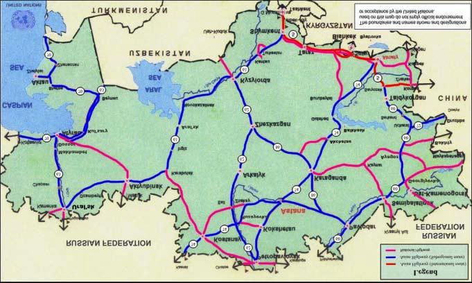
54 G/HA.-9O"IJ/57/6H;/H;03L6-701.F/6C3E3F;
55 The road length by technical standards and categories is shown in tables 43 and 44 respectively. (3B?-MD"$134?-6H7;BL7->;6/>3? $134>?355/2/>37/16 Q-6H7;BL7->;6/>3? RF=U I II III IV V )1 >37-H1.L (173??-6H7; RF=U Main or national highway 810 3,188 12, ,670 Secondary or regional highway 18 1,316 19,557 41,153 2,869 4,550 69,483 (173? [<[ M`O\M D<`MOT M9`TOD <`[SM M`T9T [T`9OD (3B?-MM"$134?-6H7;BL>37-H1.L (length in km) *->7/165 9SS9 9SSD 9SSO 9SST Main or national highway Secondary or regional highway (173? *AB7173? 9T`<[M 9T`M9< 9T`M<\ 9T`PT\ Paved only 16,990 17,255 17,271 17,503 (Percentage paved) (98) (99) (99) (99) *AB7173? PS`OD\ PO`D9D T\`9O< PO`OS9 Paved only 64,123 65,271 64,987 64,933 (Percentage paved) (92) (93) (93) (94) *AB7173? [P`[9M [T`[TD [T`OT< [T`9OD +3,-416?L [9`99D [<`OP[ [<`ODP [<`MDP R+-.>-673H-83,-4U RSDU RSMU RSMU RSOU The length of roads by classification and surface type is shown in table 45. (3B?-MO"Q-6H7; BL>?355/2/>37/163645A.23>-7L8- :?355/2/>37/16 Q-6H7; RF=U ( as of 1997 ) $1345A.23>-7L8- +3,-4 _.3,-? %7;-.5 km % km % km % Main or national highway 17,670 16, , Secondary or regional highway 69,483 42, , ,550 7 (173? [T`9OD OS`\SP P[ <D`DM\ <[ M`T9T O -46-
56 The poor pavement condition of roads is the result of a lack of resources for appropriate maintenance and reconstruction. Pavements for most sections are designed for 10-ton axle loads. Road condition by surface type is shown in table 46. (3B?-MP"$134>164/7/16 (in km) *->7/165 9SS9 9SSD 9SSO 9SST Bituminous 53,793 56,277 56,429 59,096 Pavement Cement Subtotal 53,793 56,277 56,429 59,096 Gravel and stabilized soil pavement 27,320 26,291 26,097 23,340 Unpaved 5,701 5,305 5,046 4,717 (173? [P`[9M [T`[TD [T`OT< [T`9OD Most of the public roads have two lanes. Detailed data for the number of lanes and missing links concerning road classification are shown in table 47. (3B?-MT"Q-6H7; BL.134>?355/2/>37/1656A=B-.12? =/55/6H?/6F5 *->7/165 Q-6H7; N1.-7;36 P?36-5 M?36-5 <?36-5 9?36- (in km) N/55/6H?/6F5 Main or national highway 17, Secondary or regional 69, ,046 2,869 4,550 highway (173? [T`9OD X [<[ P<`T9M <`[SM M`T9T (d) Traffic characteristics on major road networks The analysis of traffic volume over the period demonstrated the decrease in traffic volume in because of slow economic growth. The traffic volume stabilized in During this period the significant growth of motor vehicle fleets was observed on some important roads. Average annual daily traffic on the Republican roads does not exceed 5,000 vehicle/day. The proportion of motor roads with a traffic volume of less than 2,000 vehicle/day is about 70 per cent of the whole republic network. This clearly indicates the requirement of resources to enlarge cargo turnover of motor roads by improving their operating conditions. Average daily traffic is shown in figure 16. (e) International road links to neighbouring countries Kazakhstan is bounded by China in the east, Kyrgyzstan and Uzbekistan in the south, the Caspian Sea and a small section of Turkmenistan in the west, and the Russian Federation in the north. The border-crossing points are identified below: -47-
57 1. Kazakhstan border-crossing points to China (i) International: Bakhty Korgas Semipalatinskaya Oblast Taldykorganskaya Oblast (ii) Open for bilaterial traffic movement: Dostyk Maikapchagai Kol'shat Narynkol Alekseyevka Taldykorganskaya Oblast East - Kazakhstanskaya Oblast Almatinskaya Oblast Almatinskaya Oblast East - Kazakhstanskaya Oblast 2. Kazakhstan border-crossing points to CIS republics: Kegen Muratbaev Zhibek Zholy Korday Merke Ganyushkino Zhelaevo Martuk Kaerak Chistoe Kara-kuga Pnirtyshskoe Sherbakty Krasnyy Aul Zhanaozen Almatinskaya Oblast Gani South - Kazakhstanskaya Oblast South - Kazakhstanskaya Oblast Zhambylskaya Oblast Zhambylskaya Oblast Atyrauskaya Oblast West - Kazakstanskaya Oblast Actyubinskaya Oblast Kustanayskaya Oblast North - Kazakhstanskaya Oblast North - Kazakhstanskaya Oblast Pavlodarskaya Oblast Pavlodarskaya Oblast Semipalatinskaya Oblast Mangistauskaya Oblast (f) Development plans (i) Long-term development plans In 1995, the Department of Motor Roads of the Ministry of Transport and Communications of Kazakhstan formulated a long-term plan for the improvement and development of motor roads for The plan is outlined in table /145 Q-6H7; RF=U (3B?-M["(;-1A7?/6-127;-= ,-?18=-678?36 N3Z1..-83/. :157 R7;1A Y*hU Q-6H7; RC=U N/ /. :157 R7;1A Y*hU N3/67-636>- 8?36 R7;1A Y*hU (173?BA4H-7 R7;1A Y*hU , ,371 19, , , , , ,066 14, , , , , ,166 12, , , ,642 Total 19,097 1,041,603 46, , ,735 2,192,
58 The mid-term National Road Development Plan is based on the State Investment Programme of Kazakhstan which gave priority to the modernization and rehabilitation of the republican motor roads and construction of new roads and bridges. (ii) Short-term development plans The maintenance of the existing road network is the goal of a short-term road development plan. This plan is annually being worked out on the basis of financial resources allocated by the Transport Department of the Ministry of Transport and Communications. -49-

59 G/HA.-9P"&,-.3H-43/?L7.322/>/6C3E3F;
60 M"N16H1?/3 (a) Basic data Mongolia is a landlocked country in north-central Asia located between the Russian Federation in the north and China in the south. It is Asia's sixth largest country in size and one of the smallest in population. Its shape is an elongated oval, measuring 2,392 kilometres from west to east and, at its maximum 1,259 kilometres from north to south. It occupies about 1,564,100 square kilometres of land and the total population was 2,430,000 in 1999, with a current growth rate of 1.4 per cent. Until 1990 Mongolia had a socialist centrally planned economy related to the former Soviet Union. Thereafter, democratic reforms started characterizing the country's difficult transition to a market-based economy. In 1999 GDP was 873,680,000,000 tugrik. The agriculture sector has a share of about 35 per cent of GDP and the manufactureing sector has a share of about 21 per cent of GDP. Agriculture has traditionally employed as much as one half of the workforce but produces only about one fourth of GDP. Industries and mining account for more than one fourth of GDP and employ almost one fifth of the workforce. The manufacturing sector is not developed well, which leads to the import of many consumer goods. Most of Mongolia's industries are concentrated at Ulaanbaatar. (b) General transport Mongolia's transportation system consists of road networks, railways connecting Ulaanbaatar with the Russian Federation and China, and the international airport at Ulaanbaatar. The total length of the national road network is 49,250 kilometres. Road development indicators are shown in table 49. (3B?-MS"$1344-,-?18=-67/64/>371.5 :?355/2/>37/16 9SS9 9SSD 9SSO 9SST Population (thousands) 2,187 2,250 2,317 2,387 Population density (person/sq.km) Road density (km/sq.km) Number of vehicles 43,621 47,575 56,428 70,088 Number of driving licences (thousands) The modal share of summer domestic and international transport freight, and passenger movement are shown in tables 50, 51, 52 and 53. International freight transport by railway is shown in table
61 (3B?-O\"G.-/H;7=1,-=-67 (in 000 tons) ( SSD ^ 9SSO ^ 9SST ^ Road 3, , , Railway 11, , , Inland waterway Air (173? 9M`[MP"S 9\\"\ 9\`P\D"P 9\\"\ S`OPD"D 9\\"\ (3B?-O9"G.-/H;77.322/>,1?A=- (in million ton-km) ( SS9 ^ 9SSD ^ 9SSO ^ 9SST ^ Road 1, Railway 3, , , , Inland waterway Air (173? M`D[\"S 9\\"\ <`[\O"< 9\\"\ <`MDT"9 9\\"\ <`P[P"9 9\\"\ (3B?-O<"+355-6H-.,1?A=- (million passengers) ( SS9 ^ 9SSD ^ 9SSO ^ 9SST ^ Road Railway Air (173? <9P"M 9\\"\ 9S9"[ 9\\"\ 99\"D 9\\"\ [\"[ 9\\"\ (3B?-OD"+355-6H />,1?A=- (in million passenger- km) ( SS9 ^ 9SSD ^ 9SSO ^ 9SST ^ Road Railway Air (173? 9`M<9"9 9\\"\ 9`OT<"T 9\\"\ 9`M<M"< 9\\"\ 9`T<O"T 9\\"\ -52-
62 (3B?-OM"! /163?2.-/H; BL.3/?03L! /163? 2.-/H;7 (165 Ri\\\5U 9SS9 9SSD 9SSO 9SST N/??/16 716"F= (165 Ri\\\5U N/??/16 716"F= (165 Ri\\\5U N/??/16 716"F= (165 Ri\\\5U N/??/16 716"F= Export 1, Import 1, Transit , (173? D`9OP"TO 9`M9O"<9 <`<TD"DS [`TMT"PM 9`[PM"SO 9`\9<"9S 9`SMM"PP 9`DOP"MT The modal share of vehicle fleet composition is shown in table 55. (3B?-OO"(.-64/6.134,-;/>?-2?--7>1=815/7/16 V-;/>?-7L8. 9SS9 9SSD 9SSO 9SST (173? SO`OPM [T`SD< SO`P[\ 9\T`OMD 4 or more wheelers *AB7173? O<`\9< OP`[[D PT`[PM [9`M<T Passenger car 11,880 20,220 23,975 35,578 Buses 1,928 1,881 2,790 3,982 Trucks 38,204 34,782 41,099 41,867 Motorcycles 43,552 31,049 27,816 26,116 (c) Road traffic The difficult conversion of the Mongolian economy to a market economy did not much influence the traffic volume. The traffic volumes for different vehicle classes are indicated in table 56. (3B?-OP"(.322/>,1?A=- (in million vehicle-km) V-;/>?->?355 9SS9 ^ 9SSD ^ 9SSO ^ 9SST ^ Cars Buses Trucks (173? 9`M<M 9\\"\ 9`D[9 9\\"\ 9`[MD 9\\"\ <`9O9 9\\"\ The average annual distance travelled is shown in table
63 (3B?-OT"&,-.3H-366A3?4/5736>-7.3,-??-4 V-;/>?->?355 9SS9 9SSD 9SSO 9SST Cars 20,000 22,500 23,700 24,100 Buses 128, , ,000 95,000 Trucks 42,000 35,000 33,000 30,000 Half of Mongolia s imports originate from the Russian Federation and one third of its exports is destined there to. Mongolia depends on the rail-served corridor through China for more than 80 per cent of its international trade, its main destination being the Tianjin seaport. Transport between China and the Russian Federation, as well as between China and European countries through the Trans- Siberian Railway, passes through Mongolia. There is the potential for growth of the transport of containers between Dzamiin-Uud and Ulaanbaatar, and of transit goods on the section between Dzamiin-Uud and Suhbaatar. 58. The major origins and destinations of international transport in Mongolia are shown in table (3B?-O["N3Z1.1./H/ /637/16512/ /163? /6N16H1?/3 N3Z1.1./H/ /637/16512/ /163? Ulaanbaatar Olgiy Tosontsengel Harhorin Ondorhaan Choybalsan Saynshand Capital of Mongolia $-=3.F5 Animal husbandry, textile manufacture Agricultural centre, light industry Animal husbandry, agricultural centre, light industry, tourist centre Animal husbandry, agricultural centre, mining, light industry Animal husbandry, agricultural centre, energy production, construction materials manufacture Animal husbandry, agricultural centre China is Mongolia's second largest trading partner after the Russian Federation. However, the volume of physical trade is still small for such a large neighbour with a large population and heavy industry relatively close to the frontier. (d) Status and condition of the national road network The road classification system of Mongolia subdivided roads into functional classes, according to their service status. They are divided into two classes: state roads and regional roads. The length of different types of roads in Mongolia is shown in table 59. The study for the development of the Asian Highway network in 1995 included 2,368 kilometres of national roads in Mongolia in the Asian Highway network. Most of the national routes included in the Asian Highway network are in a poor state. Only a small portion of these routes is paved, the remaining portion still consists of dirt tracks. -54-
64 The existing Asian Highway routes in Mongolia are: A-3 Border of the Russian Federation -Darhan-Ulaanbaatar-Saynshand-Dzamiin-Uud - Chinese border - 1,027 kilometres A-83 Darhan-Erdenet-Bulgan-Moron-Ulaangom-Borshoo -1,347 kilometres Figure 17 indicates the road network and existing Asian Highway network in Mongolia. (3B?-OS":?355/2/>37/ :?355/2/>37/16 Q-6H7;RF=U State road 11,063 Regional road 38,187 Total 49,250 The state roads provide connections between Ulaanbaatar and major cities and centres of Aimags (there are 21 Aimags in Mongolia). Regional roads provide connections to the centres of Aimags and Sums (Aimags are divided into Sums). The Ministry of Infrastructure Development is responsible for state and regional roads, and construction, improvement and maintenance of roads is under the responsibility of the Department of Roads. The road length by technical standards is shown in table 60 and road length by categories is shown in table 61. (3B?-P\"$134?-6H7;BL7->;6/>3? (as of 1997) (173? Q-6H7;BL7->;6/>3? RF=U $134>?355/2/>37/16?-6H7;!!!!!!!V V RF=U Main or national highway - - 1,283 1,334 8,446 11,063 Secondary or regional highway ,302 38,187 (173? X X 9`PT[ 9`[<M MO`TM[ MS`<O\ -55-

65 G/HA.-9T"IJ/57/6H F/6N16H1?/3-56-
66 (3B?-P9"$134?-6H7;BL>37-H1.L (length in km) *->7/165 9SS9 9SSD 9SSO 9SST Main or national *AB7173? 9\`O<\ 9\`O<\ 9\`[P< 99`\PD highway Paved only 1,055 1,055 1,244 1,283 (% paved) (10) (10) (11.4) (11.6) Secondary or regional *AB7173? D[`TD\ D[`TD\ D[`D[[ D[`9[T highway Paved only (% paved) (0.52) (0.52) (1.03) (1.03) *AB7173? MS`<O\ MS`<O\ MS`<O\ MS`<O\ (173? +3,-416?L 9`<OT 9`<OT 9PSD 9`PT[ R^83,-4U R<"OU R<"OU RD"DU RD"MU Tables 62 and 63 show the length of road by surface type, which shows the majority is in a poor condition, indicating a lack of financial resources and insignificant growth in the length of paved roads. (3B?-P<"Q-6H7; BL>?355/2/>37/163645A.23>-7L8- :?355/2/>37/16 Q-6H7; $1345A.23>-7L8- (as of 1997) +3,-4 _.3,-? %7;-.5 RF=U RF=U R^U RF=U R^U RF=U R^U Main or national highway 11,063 1,283 (2.6) 1,334 (2.7) 8,446 (17.2) Secondary or regional highway 38, (0.8) ,302 (75.7) (173? MS`<O\ 9`PT[ RD"MU 9`[<M RD"TU MO`TM[ R[<"SU (3B?-PD"$134>164/7/16 (length in km) *->7/165 9SS9 9SSD 9SSP 9SST Pavement Bituminous 1,123 1,169 1,558 1,587 Cement *AB7173? 9`<9< 9`<OT 9`PMS 9`PT[ Gravel and stabilized soil pavement 3,677 3,684 3,767 3,731 Unpaved 44,361 44,309 43,844 43,841 (173? MS`<O\ MS`<O\ MS`<O\ MS`<O\ Most of the state and regional roads in Mongolia have one lane only. Detailed data for the number of lanes according to the road classification are shown in table
67 (3B?-PM"Q-6H7; BL.134>?355/2/>37/163646A=B-.12?36-5 *->7/165 Q-6H7; RC=U N1.- 7;36P?36-5 M?36-5 <?36-5 RC=U 9?36-5 Motorway Main or national highways Secondary or regional roads 11, ,283-38, (173? MS`<O\ X X 9`PT[ X (e) International road links to neighbouring countries Mongolia is bounded in the north by the Russian Federation and in the south by China. Mongolian border-crossing points are shown in table 65. (3B?-PO"N16H1?/36B1.4-.X>.155/6H81/6750/7;6-/H;B1A./6H>1A67./-5 )-/H;B1A./6H>1A67.L China Russian Federation W1.4-.X>.155/6H81/67 Bulgan Dayan Dzamiin-Uud Altanbulag Tsagaannuur Ereentsav Hankh In addition, there are six seasonable border crossings along the Chinese border. The volume of incoming/outgoing road traffic for major border-crossing points is shown in table 66. The average daily traffic is shown in figure 18. W1.4-.X>.155/6H 81/67 (3B?-PP"$ />,1?A=-37B1.4-.X>.155/6H81/675 :?355/2/>37/16 9SS9 9SSD 9SSO 9SST Altanbulag Total vehicles 21,120 29,010 17,438 12,396 Dzamiin-Uud Total vehicles 2,497 45,379 69, ,571 Tsagaannuur Total vehicles 6,820 7,925 6,944 5,056 Bulgan Total vehicles 1,210 1,572 7,507 5,090 Dayan Total vehicles 1,230 1,180 1,289 1,259 (173? D<`[TT [O`\PP 9\<`OOM 9MD`DT< The condition of roads leading to border-crossing points is shown in table
68 :1A67.L (3B?-PT":164/7/ ?-34/6H71B1.4-.X>.155/6H81/675 W1.4-.X>.155/6H 81/67 $134 >?355/2/>37/16 )1"12?36-5 China Dzamiin-Uud State 2 Asphalt Russian Altanbulag State 2 Asphalt Federation Russian Tsagaannuur State 1 Gravel Federation China Bulgan State 1 Gravel China Dayan State 1 Earth $134>164/7/16 R5A.23>-7L8-U The total number of passenger and traffic volumes across each border-crossing point is shown in table 68. (3B?-P["(173?6A=B H />,1?A=-537B1.4-.X>.155/6H81/675 :1A67.L W1.4-.X H-.5R7;1A V-;/>?-R7;1A ,-;]L-3.U >.155/6H ]L-3.U 81/67 9SS9 9SSD 9SSO 9SST 9SS9 9SSD 9SSO 9SST China Russian Federation Russian Federation Dzamiin- Uud Altanbulag Tsagaannuur China Bulgan China Dayan The major container terminals of Mongolia are located at railway stations in Ulaanbaatar, Darhan, Erdenet and Dzamiin-Uud. (f) Development plans A master plan for the medium-term development of the road network of Mongolia was formulated in According to this plan, 24 high priority routes were planned for construction in the medium term, during the period Road construction and maintenance works is currently being carried out along some parts of these routes. The medium-term plan has been reviewed and a road network development plan for 2010 has been formulated based on the initial master plan and government action programme. Recently, the Government of Mongolia initiated and prepared the Millennium Road plan with the purpose of connecting neighbouring and regional countries to facilitate the provision of consumer products and services, to develop transport and to improve the living standards of the population of the region. The Millennium Road includes one horizontal arterial road passing through the capital linking the east and west of the country and five vertical arterial roads. The Millenium Road plan was approved by the Parliament of Mongolia on 25 January

69 G/HA.-9["&,-.3H-43/?L7.322/>/6N16H1?/3-60-
70 O"(;-$-8AB?/>12C1.-3 (a)basic data The Republic of Korea occupies the southern portion of the Korean peninsula. The country is bordered by the Democratic People's Republic of Korea in the north, the Sea of Japan in the east, the East China Sea in the south, and the Huang He Sea in the west; in the south-east it is separated from Japan by the Korea Strait. The Republic of Korea faces the Democratic People s Republic of Korea across a demilitarized zone that runs for about 240 kilometres from the mouth of the Han River on the west coast of the Korean peninsula to the south of the town of Kosong in the Democratic People's Republic of Korea on the east coast. The area of the Republic of Korea is 99,707 square kilometres, which is about 45 per cent of the peninsula. The population of the Republic of Korea was 46,860,000 in 1999 and the current growth rate is 0.9 per cent. The Republic of Korea has a predominantly market economy based largely on services and light and heavy industries. Economic growth has been heavily dependent on exports of manufactures. GDP in 1999 was 483,778,000,000,000 won and is growing much faster than the population. GNP per capita is similar to those of the other rapidly developing East Asian countries. Agriculture now accounts for only a small proportion of GDP and employs about one seventh of the workforce. Manufacturing industries account for more than one fourth of GDP and employ nearly one fourth of the workforce. Most industries are owned and run by families, and relatively few firms are listed on the nation's stock exchange. Exports of goods and services represent more than one third of the country's GNP. (b) General transport The transport system was expanded and improved considerably after 1960, especially with the creation of a modern highway network and the establishment of nationwide air service. Road transport now accounts for the bulk of passenger travel and most movement of freight. The bus transportation network is well developed. The Republic of Korea has 84,968 kilometres of a welldeveloped national road network. The Republic of Korea railways are largely government-owned. Until 1960 rail travel was the major means of inland transportation for both freight and passengers, but since has been superseded by road transport, and, more recently, also by air transport. Currently Seoul and Pusan is connected by a high-speed railway and the construction of another high-speed railway track to connect the capital Seoul and the new international airport at Inch+on is ongoing. The total length of the railway is 3,120 kilometres. The cities of Seoul and Pusan have extended subway systems, as do Inch on and Taegu. Internal air transport began in the early 1960s. Most major cities now have scheduled air services. Kimp'o International Airport, at Seoul, served as the country's main port of entry until the opening of the new international airport at Inch+on on 29 March The new Inch,on international airport is planned as a hub of North-East Asia. Pusan and Cheju also have international airports. Port facilities have been expanded considerably with the tremendous growth in trade. Major ports include Pusan, Inch'on and Kwangyang. Road development indicators are shown in table
71 (3B?-PS"$1344-,-?18=-67/64/>371.5 :?355/2/>37/16 9SS9 9SSD 9SSO 9SST Population (thousands) 43,296 44,195 45,093 46,885 Population density (person/sq. km) Road density (km/sq km) Number of vehicles 4,247,816 6,274,008 8,468,901 10,413,427 Number of driving Licences (thousands) 9,844 13,302 16,404 18,532 The modal share of domestic transport, freight and passenger movement is shown in tables 70, 71, 72, and 73. :?355/2/>37/16 (3B?-T\"G.-/H;7=1,-=-67 (in 000 tons) 9SS9 9SSD 9SSO 9SSP ^ ^ ^ ^ Road 245, , , , Railway 61, , , , Air Ship 76, , , , (173? D[<`PPO 9\\"\ MMP`\[P 9\\"\ OSO`<T< 9\\"\ P<9`<MD 9\\"\ (3B?-T9"G.-/H;77.322/>,1?A=- (in million ton-km) :?355/2/>37/16 9SS9 9SSD 9SSO 9SSP ^ ^ ^ ^ Road 10, , , , Railway 14, , , , Air Ship 24, , , , (173? MS`[M\ 9\\"\ PP`9SM 9\\"\ TP`99\ 9\\"\ T[`PMT 9\\"\ -62-
72 (3B?-T<"+355-6H-.,1?A=- (million passengers) :?355/2/>37/16 9SS9 9SSD 9SSO 9SSP ^ ^ ^ ^ Road 12, , , , Railway Inland waterway 1, , , , Air Ship (173? 9M`[\< 9\\"\ 9M`<DT 9\\"\ 9D`OOT 9\\"\ 9D`[\9 9\\"\ :?355/2/>37/16 (3B?-TD"+355-6H />,1?A=- (in million passenger-km) 9SS9 9SSD 9SSO 9SSP ^ ^ ^ ^ Road 87, , , , Railway 33, , , , Subway 11, , , , Air 4, , , , Ship (173? 9D[`\<S 9\\"\ 9D\`[D[ 9\\"\ 9<D`OT< 9\\"\ 9<M`9MO 9\\"\ As indicated in tables 70 and 72, about 83 per cent of passengers and 69 per cent of freight transport rely on road transport. The modal share of international freight and passenger movements is shown in tables 74, 75, 76 and 77. The figure in table 68 shows there is no international freight movement through road and railway because of the closed borders with the Democratic People s Republic of Korea. :?355/2/>37/16 (3B?-TM"G.-/H;7,1?A=- (in 000 tons) 9SS9 9SSD 9SSO 9SSP ^ ^ ^ ^ Air , , Ship 262, , , , (173? <PD`TOS 9\\"\ D9T`[<D 9\\"\ M\O`T9O 9\\"\ MM<`OO9 9\\"\ -63-
73 (3B?-TO"G.-/H;77.322/>,1?A=- (in million ton-km) :?355/2/>37/16 9SS9 9SSD 9SSO 9SSP ^ ^ ^ ^ Air 4, , , , Ship 2,168, ,768, ,263, ,575, (173? <`9TD`\O< 9\\"\ <`TTM`OTS 9\\"\ D`<T9`[9D 9\\"\ D`O[M`T[[ 9\\"\ (3B?-TP"+355-6H-.,1?A=- (thousand passengers) :?355/2/>37/16 9SS9 9SSD 9SSO 9SSP ^ ^ ^ ^ Air 10, , , , Ship (173? 9\`P\P 9\\"\ 99`SMT 9\\"\ 9M`SS[ 9\\"\ 9P`O9O 9\\"\ (3B?-TT"+355-6H />,1?A=- (in million passenger-km) :?355/2/>37/16 9SS9 9SSD 9SSO 9SSP ^ ^ ^ ^ Air 38, , , , Ship (173? D[`PDM 9\\"\ MT`TDS 9\\"\ P9`TMS 9\\"\ T\`P[[ 9\\"\ The modal share of vehicle composition is shown in table 78. V-;/>?->?355 (3B?-T["(.-64/6.134,-;/>?-2?--7>1=815/7/16 (vehicle/day) 9SS9 9SSD 9SSO 9SST (173? <[`9M\ D[`S\M MM`PDM MS`SSD *AB7173? +-.>-673H- <[`\T\ RSS"TU D[`[MS RSS"SU MM`OTD RSS"SU MS`SDP RSS"SU Passenger car percentage 4 or more wheelers 12,030 (42.8) 18,373 (47.2) 22,354 (50.1) 26,818 (53.7) Buses percentage 4,287 (15.2) 5,748 (14.8) 5,659 (12.7) 5,955 (11.9) Trucks percentage 11,753 (41.7) 14,728 (37.9) 16,560 (37.1) 17,163 (34.3) Others Percentage 70 (0.3) 55 (0.1) 61 (0.1) 57 (0.1) -64-
74 (c) Road traffic According to the forecast of the Ministry of Construction and Transportation, the traffic volume on rural roads in 2011 will increase by 2.5 times the present traffic and vehicle registration will increase by three times. The yearly traffic by vehicle class is shown in table 79. V-;/>?->?355 (3B?-TS"(.322/>,1?A=- (vehicle/day) 9SS9 9SSD 9SSO 9SSP ^ ^ ^ ^ Cars 16, , , , Buses 6, , , , Trucks 15, , , , Others (173? DS`\[D 9\\"\ OM`9[[ 9\\"\ PM`D99 9\\"\ TP`<9S 9\\"\ The short distance between cities characterizes the geographical features of the country. The average annual distance travelled is shown in table 80. (3B?-[\"&,-.3H-366A3?4/5736>-7.3,-??-4 (in thousand vehicle-kms) V-;/>?->?355 9SSD 9SSO 9SST Cars 112, , ,006 Buses 35,844 23, Trucks 77,221 91, ,038 Others The major origins and destinations of international transport in the Republic of Korea are shown in table 81. (3B?-[9"N3Z1.1./H/ /637/16512/ /163? /67;-$-8AB?/>12C1.-3 N3Z1.1./H/65]4-57/637/16512 / /163? Seoul Cheju Inch'on Pusan Kwangyang $-=3.F5 Capital International tourist centre International port International port International port -65-
75 (d) Status and condition of the national road network Roads are classified according to the Road Legislation into seven classes, national expressways, national highways, special city roads, city roads, provincial roads, county (Gun) roads and district (Gu) roads. The length of roads in the Republic of Korea is shown in table 82. Figure 19 indicates the road network in the Republic of Korea. (3B?-[<":?355/2/>37/ (as of 1997) :?355/2/>37/16 Q-6H7;RF=U National expressway 1,889 National highway 12,459 Special greater city road 17,243 Provincial road 17,089 City road Country (Gun) road 36,288 District (Gu) road (173? [M`SP[ The national expressway is the main artery of the country and used exclusively by high-speed motor vehicles for linking major urban centres. National highways links the major urban and industrial areas, including ports and harbours, airports and tourist resorts. Together with the national expressways, they are part of the national principal road network. The roads in Seoul are classified as special greater city roads, and roads in large cities with one million or more, including Pusan, Taegu, Inch-on, Kwangju and Taejon, are classified as city roads. Provincial roads are roads of a secondary network, which provides linkages between the provinces, municipalities and counties. County (Gun) roads connect villages with their county centres or with neighbouring towns. District (Gu) roads connect subdistricts within the boundaries of each district. The Ministry of Construction and Transportation is responsible for the administration, planning, design, construction and maintenance of all public roads. The local governments are responsible for their respective road networks under the supervision of the Ministry of Construction and Transportation. -66-
76 G/HA.-9S"K/H;03L6-701.F/67;-$-8AB?/>12C
77 The road length by technical standards is shown in table 83 and road length by categories is shown in table 84. $134>?355/2/>37/16 Motor way (accesscontrolled highway) (3B?-[D"$134?-6H7;BL7->;6/>3? Q-6H7;BL7->;6/>3? RF=U!!!!!!!V V (as of 1997) (173??-6H7; RF=U 1, ,889 Main or national highway ,521 9, ,459 Secondary or regional highway ,936 17,243 Other roads ,153 50,224 53,377 (173? 9`M<\ S[S <`O[9 9<`OP9 PT`M9T [M`SP[ (3B?-[M"$134?-6H7;BL>37-H1.L *->7/165 9SS9 9SSD 9SSO (length in km) 9SST *AB7173? 9`OST 9`P\< 9`[<O 9`[[S National expressway Paved only 1,597 1,602 1,825 1,889 (Percentage) (100) (100) (100) (100) National highway Special greater city road Provincial road City road and country road and district road (173? Paved only (Percentage) *AB7173? 9<`99M 9<`\OT 9<`\OD 9<`MOS Paved only 11,140 11,800 11,993 12,202 (Percentage) (92) (98) (99.5) (97.94) *AB7173? 9<`T9T 9D`DDP 9M`\[< 9T`<MD Paved only 10,717 11,444 12,759 15,673 (Percentage) (84) (86) (91) (91) *AB7173? 9\`PMD 9\`POP 9D`[OM 9T`\[S Paved only 7,725 9,120 9,853 12,726 (Percentage) (73) (86) (71) (74) *AB7173? <9`\9P <D`PMM D<`M<M DP`<[[ Paved only 13,198 17,922 19,956 20,378 (Percentage) (63) (76) (62) (56) *AB7173? O[`\[[ P9`<SO TM`<DT [M`SP[ 44,378 (76) 51,888 (85) 56,386 (76) 62,868 (74) The length of roads by classification and surface type and condition of roads are shown in tables 85 and
78 :?355/2/>37/16 (3B?-[O"Q-6H7; BL>?355/2/>37/163645A.23>-7L8- Q-6H7; RF=U [as of 1997] $1345A.23>-7L8-83,-4 Y683,-4 17;-.5 F= ^ F= ^ F= ^ National expressway 1,889 1, National highway 12,459 12, Special greater city road 17,243 15, , Provincial road 17,089 12, , ,316 8 City road & country road and district road 36,288 20, , ,955 8 (173? [M`SP[ P<`[P[ TM 9T`99[ <\ M`M[< P (3B?-[P"$134>164/7/16 (length in km) *->7/16 9SST Asphalt (percentage) 52,676 (83.79) Paved Cement 10,192 (percentage) (16.21) Subtotal (percentage) 62,868 (100) Unpaved 22,100 (173? [M`SP[ Most roads in the Republic of Korea have two lanes. Detailed data for the number of lanes and missing links concerning road classification are shown in table 87. (3B?-[T"Q-6H7; BL.134>?355/2/>37/16`6A=B-.12? =/55/6H?/6F5 :?355/2/>37/16 Q-6H7;RF=U N1.-7;-6P?36-5 M?36-5 <?36-5 N/55/6H?/6F National expressway 1, , National highway 12, ,521 9, Special greater city road 17,243 2,101 1,912 11,660 1,570 Provincial road 17, ,419 4,363 City road, country road and district road 36,288 1,052 2,025 17,301 15,910 (173? [M`SP[ M`\\M T`[OD O9`\9\ <<`9\\ -69-
79 The major roads of the national road network, their length, and average daily traffic, including composition of traffic according to classification of vehicle types, are shown in tables 88, and 89. Average daily traffic is shown in figure 20. (3B?-[["(.322/>>;3.3>7-./57/>516=3Z F5 )1" *->7/16 :?355/2/>37/ &'( 1 SongnamSampyung 17.1 km from Seoul Kyungbu highway 245,783 2 Yongin Giheung 30.0 km from Seoul Kyungbu highway 200,975 3 SongnamGungnae 20.5 km from Seoul Kyungbu highway 196,713 4 Seoul Yangjae 6.8 km from Seoul Kyungbu highway 188,805 5 Seoul Wonji 12.2 km from Seoul Kyungbu highway 187,128 6 Yongin Giheung 34.0 km from Seoul Kyungbu highway 169,017 7 Seoul Seocho 4.0 km from Seoul Kyungbu highway 165,891 8 Puch'on Dodang 3.5 km from Seoul Kyungin highway 161,366 9 Suwon-Seoul National Road No.1 159, Hwasung Dongtan 40.0 km from Seoul Kyungbu highway 153, Inch'on Seochang 8.0 km from Seoul Kyungin highway 143, Yongin Namsa 51.9 km from Seoul Kyungbu highway 138, Chungwon Nami km from Seoul Kyungbu highway 127, Daeduk Moksang km from Seoul Kyungbu highway 126, Anyang-Seoul National Road No , Inch'on Seoun 6.3 km from Seoul Kyungin highway 123, Daeduk Dukam km from Seoul Kyungbu highway 122, Ch onan Jiksan 78.5 km from Seoul Kyungbu highway 119, Kangdong Hail 23.0 km from Pankyo Pankyo-Kuri highway 119, Seoul Sinsa 2.3 km from Seoul Kyungbu highway 118, Daeku Sungseo 4.4 km from Keumho Kuma highway 114, Kuri Topyung 26.9 km from Pankyo Pankyo-Kuri highway 106, Dalsung Hawon 10.7 km from Keumho Kuma highway 106, Hanam Dukpung 21.0 km from Pankyo Pankyo-Kuri highway 104, Inch'on Gajung 13.2 km from Seoul Kyungin highway 102, Suwon-Seoul National Road No.1 101, Ansan Bukok 20.0 km from Singal Singal-Ansan highway 100, Ch onan Songnam96.2 km from Seoul Kyungbu highway 99, Inch'on Gajwa 17.5 km from Seoul Kyungin highway 99, Seoul Sinsa 1.0 km from Seoul Kyungbu highway 98,486 Note: ADT = average daily traffic -70-
80 (3B?-[S":1=815/7/ />BL>?355/2/>37/16 V-;/>?-7L8- &'([volume/day] Total 49,993 Composition of traffic Cars percentage Buses percentage Trucks percentage Others percentage 26,818 (53.7) 5,955 (11.9) 17,163 (34.3) 57 (0.1) (e) International road links to neighbouring countries The Republic of Korea has a single land boundary on the north with the Democratic People s Republic of Korea. The location of border-crossing points of the Republic of Korea with the Democratic People s Republic of Korea are shown in table 90. (3B?-S\"W1.4-.X>.155/6H81/675 :1A67./-5 Cities $-8AB?/>12C1.-3 Paju-si Musan Paju-si Nulno-ri Yonchon-gun Mageo-ri Ch orwon Oechon-ri Ch orwon Eupnae-ri Ch orwon Eupnae-ri Ch orwon Oechon-ri Ch orwon Jupa-ri Kosong-gun Pohwajin-ri Yanggu-gun Bia-ri Yanggu-gun Gunsol-ri Yanggu-gun Gajun-ri '-=1>.37/>+-18?-g5$-8AB?/>12 C1.-3 Kaesong Jangpung-gun Limgang-ri Jangpung-gun Janghak-ri Pyonggang-ri Pyonggang Pyonggang-ri Chonam-ri Kimhwa-gun Sutae-ri Ch orwon-gun Majang-ri Kimhwa-gun Yonghyun-ri Kosong-gun Kueup-ri Keumgang-gun Soksa-ri Changdo-gun Baekhyun-ri Kosong-gun Soksa-ri The condition of roads leading to the border-crossing points is shown in table 91. (3B?-S9":164/7/ ?-34/6H71B1.4-.X>.155/6H81/675 :1A67.L Border-crossing point Road classification Number of lanes Road condition (surface type) '-=1>.37/>+-18?-g5 $-8AB?/>12C1.-3 Munsan - Kaesong National road 4 lanes paved -71-
81 G/HA.-<\"&,-.3H-43/?L7.322/>/67;-$-8AB?/>12C
82 (f) Major container terminals There are 25 private container yards in the region of Pusan and two inland container depots. (3B?-S<"IJ/57/6H/6?364>1673/6-.7-.=/63?5 '-5>./87/16 CL16H/6!:' j36h536!:' Location Euiwang in Kyonggi-do Yangsan in Kyongnam Area (m 2 ) 760, ,000 Facilities Five container yards Two container freight stations Ten container yards Ten container freight stations Access by rail Possible (3 lanes) Possible (2.1 km) Capacity 1,357,000 TEU/year 980,000 TEU/year Note: ICD = inland container depots The development plans for container terminals are shown in table 93. (3B?-SD"'-,-?18=-678?36521.>1673/6-.7-.=/63?5 '-5>./87/16 :;A6HBA!:' j16h63=!:' K163=!:' Location Near Yonki Near Daeku Near Kwangju Area (sq. m.) 660, ,000 1,100,000 Facilities Container yards and container freight stations Container yards and container freight stations Container yards and container freight stations Access by rail Possible Possible Possible Capacity 1,299 TEU/day 616 TEU/day 1,104 TEU/day Note: ICD = inland container depots To supplement container terminals, the construction of logistics centre networks in the Republic of Korea is planned to strengthen the function of the existing inland logistics hubs and establish logistics centres near the seaside, and to develop port-based logistics hubs for export and import freight. To improve the coastal transportation construction of distribution networks connecting inland and seaside, ten hub ports and five multi-transport terminals are planned. (g) Development plans The Government of the Republic of Korea has long-term, mid-term and short-term national road network development plans. The following table illustrates the long-term, mid-term and shortterm development plans with regard to development of highways in the Republic of Korea. -73-
83 (3B?-SM"K/H;03L4-,-?18=-678?365 +?365 '-5>./87/16 +-./14 Long-term Short-term Highway - new construction : 1,999 km - widen : 392 km National road - new construction : 1,580 km - Bypass road : 1,194 km - Maintenance Provincial road 1,358 km (government sponsored) I57/=37-4>157 RY*h=/??/16U , , ,708 Special project ,650 Highway - new construction : 931 km - widen : 409 km National road - new construction : 1,283 km - Bypass road : 213 km - Maintenance Provincial road 185 km (government sponsored) Notes: Exchange rate in , , ,214 Special project The fundamental policy and basic framework of the development plan are: (i) Fundamental policy!" Organize a road network to prepare for the unification of the Korean peninsula and to play a key role in the Pacific rim economic bloc in the era of globalization!" For balanced national land use, organize an arterial network to lead regional development by maintaining a similar level of access roads through the country!" In order to meet the level of a twenty-first century economy, maintain and expand a road network to ensure the arterial function to enable all citizens to receive equal benefits!" On the basis of the status of and future plan for industrial facilities, organize a road network with transport efficiency to promote industrial competitiveness!" Plan transport share with other traffic modes in terms of increased demand of traffic and change in the pattern of travel!" Assure road traffic safety and smooth traffic through improved road traffic policy which emphasizes the shift from construction to the operation of roads (ii) Basic framework!" Seek balanced regional development by maximizing productivity through balanced national land use -74-
84 !" Maximize the convenient use and diversify the choice of routes through the establishment of a road network system to cope with rapidly growing traffic demand!" Promote industrial competitiveness and eliminate bottlenecks in traffic by providing linkages among major cities, large-scale industrial complexes, harbours and ports!" Establish an arterial network system to prepare for the unification of the Korea peninsula and to play a role as the centre of North-East Asia The major national arterial network plan aims to establish a grid of arterial networks consisting of seven north-south corridors and nine east-west corridors to provide equal access to every region in the country. It plans to construct the following north-south routes to link the Republic of Korea and the Democratic People s Republic of Korea: a. Mokp'o-Seoul-Sinuiju-China; b. Kwangju-Seoul-Manp'o; c. Masan-Wonju-Hyesan; d. Pusan-Kangnung-Sonbong-Russian Federation. Furthermore, the plan proposes to construct about 2,600 kilometres of additional highways in the long term in addition to 1,885 kilometres of network currently being undertaken or planned. The total length of the national arterial network will be 6,160 kilometres on completion of the national arterial network plan. Table 95 shows the national arterial network plan of the Republic of Korea. :1../41.5 (173??-6H7; N-S corridors 9 E-W corridors (3B?-SO")37/163?3.7-./3?6-701.F8?36 *AB7173? :A..-678?36 Y64-. >1657.A>7/16 +?366-4 (length in km) Q16HX7-.= 8?36 3, , ,288 2,869 1, ,300 (173? P`9P\ 9`[[O 9`P[T 9`DDO DO< <`O[[ Notes: As of 1996 There is a disparity between the growth of the vehicle fleet and road networks as the vehicle fleet is growing about four times that of the road network. Low road density and problems of financing are some of the major problems encountered in the development of the national road network. (a) Basic data P"(;-$A55/36G-4-.37/16 The Russian Federation, the world's largest country, stretches over a vast expanse of Eastern Europe and North-East Asia. Following the emergence of newly independent states from the former Soviet Union in 1991, the Russian Federation joined with other former Soviet Union countries in forming CIS. The Russian Federation covers 17,076,400 square kilometers. Most of the population is concentrated in a great triangle in the western, or European, part of the country, although over the past -75-
85 three centuries and particularly during the twentieth century, there has been a steady flow of people eastward to the Asiatic section commonly referred to as Siberia. The total population was 146,560,000 in 1999 and the population is currently decreasing at a rate of 0.5 per cent. Although the Russian Federation and the former Soviet Union as a whole had made significant progress in industrial development since 1917, and especially since 1945, the economy was in serious decline by the 1980s. GDP was 4,545,490,000,000 roubles in The Russian Federation is an industrial country, the manufacturing sector having about 63 per cent share of GDP and the agriculture sector about 13 per cent share of GDP. (b) General transport Land transport in the Russian Federation is well developed. The Trans-Siberian Railway and its feeder branches are very popular. The total length of railways is 87,000 kilometres. The national road network is not well developed compared with the rail network. The total length of the road network is 569,036 kilometres. Maritime transport with 75,000 kilometres of navigation length is an important mode, on sea, river and canal. "Aeroflot" is among the world's largest airlines in terms of quantity of fleet and flights. There are 60 international airports in the Russian Federation. The road development indicators are shown in table 96. (3B?-SP"$1344-,-?18=-67/64/>371.5 :?355/2/>37/16 9SS9 9SSD 9SSO 9SST Population (thousands) 148, , , ,502 Population density (person/sq. km) Road density (km/sq. km) Number of vehicles 23,265,556 27,191,443 31,418,643 33,848,900 The modal share of domestic transport (including to/from CIS countries) freight and passenger movement are shown in tables 97, 98, 99 and 100. _-6-.3?X8A (3B?-ST"G.-/H;7=1,-=-67 (in 000 tons) 9SS9 ^ 9SSD ^ 9SSO ^ 9SST ^ Road 2,731, ,570, ,441, ,002, Railway 1,957, ,348, ,028, , Inland waterway 514, , , , Pipe line 1,042, , , , Air 2, Ship 104, , , , (173? P`DO\`<\\ 9\\"\ O`\[S`S\\ 9\\"\ D`MOT`P\\ 9\\"\ <`[O\`[\\ 9\\"\ -76-
86 _-6-.3?X8A (3B?-S["G.-/H;77.322/>,1?A=- ( in million ton-km) 9SS9 ^ 9SSD ^ 9SSO ^ 9SST ^ Road 65, , , , Railway 2,326, ,608, ,214, ,130, Inland waterway 196, , , , Pipe line 2,404, ,019, ,899, ,913, Air 2, , , , Ship 464, , , , (173? O`MOT`M\\ 9\\"\ M`9OT`P\\ 9\\"\ D`OD<`P\\ 9\\"\ D`DPS`9\\ 9\\"\ _-6-.3?X8A (3B?-SS"+355-6H-.,1?A=- (million passengers) 9SS9 ^ 9SSD ^ 9SSO ^ 9SST ^ Bus 27, , , , Taxi Tram 7, , , , Trolley-bus 8, , , , Metro 3, , , , Railway 2, , , , Inland waterway Air Ship (173? MS`ODD 9\\"\ M[`99M 9\\"\ MO`\DT 9\\"\ MO`9P[ 9\\"\ (3B?-9\\"+355-6H />,1?A=- (in million passenger- Km) _-6-.3?X8A SS9 ^ 9SSD ^ 9SSO ^ 9SST ^ Bus 250, , , , Taxi 7, , , Tram 24, , , , Trolley-bus 23, , , , Metro 35, , , , Railway 255, , , , Inland waterway 3, , , Air 150, , , , Ship (173? TO9`[\\ 9\\"\ PP9`\\\ 9\\"\ OO<`S\\ 9\\"\ O9O`O\\ 9\\"\ -77-
87 The modal share of international freight and passenger movements is shown in tables 101, 102, 103 and 104. (3B?-9\9"G.-/H;7,1?A=- _-6-.3?X8A (in 000 tons) 9SS9 ^ 9SSD ^ 9SSO ^ 9SST ^ Road 1, , ,050 2,620 Railway 5,789, ,063, Inland waterway 17, , ,500 23,200 Air Ship 76, , ,400 48,800 (173? O`[[D`TD\ 9\\"\ M`9O9`T9\ 9\\"\ [D`9O\ TM`S<\ _-6-.3?X8A (3B?-9\<"G.-/H;77.322/>,1?A=- (in million ton-km) 9SS9 ^ 9SSD ^ 9SSO ^ 9SST ^ Road 2, , ,400 2,200 Railway 44, , Inland waterway 27, , ,300 38,400 Air ,400 Ship 421, , , ,700 (173? MST`<\\ 9\\"\ M9D`O\\ 9\\"\ DD\`D\\ <P\`T\\ _-6-.3?X8A (3B?-9\D"+355-6H-.,1?A=- (million passengers) 9SS9 9SSD 9SSO ^ 9SST ^ Bus Railway Inland waterway Air Ship (173? M"\ O"T S"O 9\\"\\ 9<"[< 9\\"\\ -78-
88 _-6-.3?X8A (3B?-9\M"+355-6H />,1?A=- (in million passenger- km) 9SS9 9SSD 9SSO ^ 9SST ^ Bus Railway Inland waterway Air 15,900 18,200 23, , Ship (173? 9P`<\9 9[`O9\ <M`M\D 9\\"\ <S`TDD 9\\"\ The modal share of vehicle fleet composition is shown in table 105. (c) Road traffic (3B?-9\O"(.-64/6.134,-;/>?-2?--7>1=815/7/16 (million vehicles) V-;/>?-7L8-9SS9 9SSD 9SSO 9SST (173? <D"\O <T"9S <S"[\ D<"M\ Subtotal Passenger cars Buses Trucks Motorcycles Table 106 shows the traffic volumes according to the class of vehicles and the increase in the volume of cars and trucks in (3B?-9\P"(.322/>,1?A=-5 (million vehicles) V-;/>?->?355 9SS9 ^ 9SSD ^ 9SSO ^ 9SST ^ Cars Buses Trucks Two-wheelers (173? <D"\O 9\\"\\ <T"9S 9\\"\\ <S"[ 9\\"\\ D<"M\ 9\\"\\ -79-
89 The major origins and destinations of international transport in the Russian Federation are shown in table 107. )1" (3B?-9\T"N3Z1.1./H/ /637/16512/ /163? N3Z1.1./H/ /637/16512/ /163? Moscow Capital '-5>./87/16 2. Sankt - Peterburg Major administrative and industrial centre in the region. It is connected by road, railway, inland waterway, air and ship, and has container terminals. 3. Rostov-na-Donu Big administrative and industrial centre. It is connected by road, rail, air and water transport with neighbouring regions and countries. 4. Novorossiysk Big administrative and industrial centre. Major sea port. It is connected by road and rail transport and has a container terminal. 5. Ryazan Big administrative and industrial centre. It is connected by road and rail transport. 6. Penza Big administrative and industrial centre. It is connected by road, air and rail transport and has a container terminal. 7. Samara Big administrative and industrial centre. It is connected by road, rail, air and water transport, and has a container terminal. 8. Ufa Big administrative and industrial centre. It is connected by road, rail, air and water transport, and a container terminal is planned. 9. Chelyabinsk Big administrative and industrial centre. It is connected by road, air and rail transport and a container terminal is planned. 10. Yekaterinburg Big administrative and industrial centre. It is connected by road, air and rail transport and has a container terminal. 11. Kurgan Big administrative and industrial centre. It is connected by road, air and rail transport and has three container terminals. 12. Omsk Big administrative and industrial centre. It is connected by road, air and rail transport. 13. Novosibirsk Big administrative and scientific centre. It is connected by railway, air and water transport and a container terminal is planned. 14. Krasnoyarsk Big administrative and industrial centre. It is connected by road, water, air and rail transport and has a container terminal. 15. Irkutsk Big administrative and industrial centre. It is connected by road, air and rail transport and a -80-
90 )1" N3Z1.1./H/ /637/16512/ /163? '-5>./87/16 container terminal is planned. 16. Khabarovsk The capital of the Khabarovsk region. It is connected by road, air, water and rail transport. 17. Vladivostok The capital of the Primorskiy region and sea port. It is connected by road, water, air and rail transport and has a container terminal. 18. Voronezh Big administrative and industrial centre. It is connected by road, air and rail transport and has a container terminal. 19. Borisoglebsk It is connected by road and rail transport. 20. Saratov Big administrative and industrial centre. It is connected by road, water, air and rail transport and has a container terminal. 21. Volgograd Big administrative and industrial centre. Major river port. It is connected by road, water, air and rail transport and has a container terminal. 22. Astrakhan Big administrative centre. Major river and sea port. It is connected by road, water and rail transport. 23. Makhachkala The capital of Dagestan Republic. Major sea port. It is connected by road, air and rail transport. A container terminal is planned. 24. Krasnodar Big administrative, industrial and agriculture centre. It is connected by road, air and rail transport. 25. Adler Major airport. It is connected by road, air and rail transport. A container terminal is planned. (d) Status and condition of the national road network Highways are classified according to SNiP into four administrative groups according to their service status in the Russian Federation. They are: State highway, republican roads, regional roads and local roads. According to the Ordinance of the Government of the Russian Federation roads ares divided in three categories: Federal (national) highways, regional highways and departmental highways. The length of roads in the Russian Federation is shown in table 108. Figure 21 indicates the road network in the Russian Federation. (3B?-9\[":?355/2/>37/ :?355/2/>37/16 Q-6H7;RF=U Federal highway (main or national highway) 45,931 Regional highway (secondary or regional highway) 523,105 Total 569,036 Note: Length of republican, regional and local roads is included into the length of regional highways. -81-
91 Federal highways provide connections between the capitals of Republics, major industrial and agricultural centres, major towns and economic centres. They provide connections within national centres (Krai, Autonomous Oblast), as well as provide international transport connections to neigbouring countries. Regional highways include roads of republican importance connecting regional and economic centres, provide connection within district centres, large industrial centres and connect with other modes of transport. Local roads connect district centres with major villages, local industrial centres and state farms. The Federal Highway Administration is responsible for the construction and maintenance of state roads in the Russian Federation. The road length by catagories and technical standards is shown in tables 109 and 110. (3B?-9\S"$134?-6H7;BL>37-H1.L (length inkm) :?355/2/>37/16 9SS9 9SSD 9SSO 9SST Main or national *AB7173? S[`P9P M\`P<< MM`9PP MO`SD9 highway Paved only (Percentage paved) 83,740 (85.9) 36,622 (90.2) 40,328 (91.4) 41,830 (91.1) Secondary or *AB7173? DOT`OMO MM[`MDT M[T`<O[ O<D`9\O regional highway Paved only (Percentage paved) 180,763 (50.6) 254,030 (56.6) (57.2) 300,294 (57.4) *AB7173? MOP`9P9 M[S`\OS OD9`M<M OPS`\DP (173? +3,-416?L <PM`O\D <S\`PO< D9[`SD< DM<`9<M R+-.>-673H-83,-4U RO[U ROS"MDU RP\"\U RP\"9<U (3B?-99\"$134?-6H7;BL7->;6/>3? $134 Q-6H7;BL7->;6/>3? (173??-6H7; :?355/2/>37/16!!!!!!!V V RF=U Main or national highway 2,554 17,456 21,082 3,250 1,206 45,548 Secondary or regional highway 760 8,122 87, ,020 72, ,171 (173? D`D9M <O`OT[ 9\[`TD[ <SS`<T\ TD`[9S O9\`T9S The length of roads by classification and surface type is shown in table
92 (3B?-999"Q-6H7; BL>?355/2/>37/163645A.23>-7L8- (as of 1997) :?355/2/>37/16 $1345A.23>-7L8- Q-6H7; +3,-4 _.3,-? %7;-.5 RF=U C= ^ C= ^ F= ^ Motorway (access-controlled - highway) Main or national highway 45,931 41, , Secondary or regional highway 523, , , , Others roads - (173? OPS`\DP DM<`9<M P\"9< 9P[`OSO \"[D O[`D9T 9\"<O Table 112 indicates the length of roads by pavement type. (3B?-99<"$134>164/7/16 (length in km) +3,-=-677L8-9SS9 9SSD 9SSO 9SST Paved Bituminous 255, , , ,485 Cement 9,463 9,364 9,976 10,639 *AB7173? <PM`O\D <S\`PO< D9[`S<T DM<`9<M Gravel and stabilized soil pavement 140, , , ,595 Unpaved 50,705 49,068 52,385 58,317 (173? MOP`9P9 M[S`\OS OD9`M<M OPS`\DP Most of the state roads have two lanes. Detailed data for the number of lanes and missing links concerning road classification are shown in table 113. (3B?-99D"Q-6H7; >?355/2/>37/16BL6A=B-.12?36-5 :?355/2/>37/16 Q-6H7; RF=U P? =1.- M?36-5 <XD?36-5 Main or national highways 41, ,258 38,675 - */6H?-?

93 G/HA.-<9k)37/163?;/H;03L6-701.F/67;-$A55/36G-4-.37/16-84-
94 The major national road networks, their lengths, average daily traffic and composition of traffic according to the classification of vehicle types are shown in tables 114 and 115. )1" $1345 (3B?-99M"(.322/>>;3.3>7-./57/>516=3Z F5 Q-6H7; RF=U (.322/>,1?A=-` 9\\\,-;/>?-5 1. M 1 Belarys M 2 Krym M 3 Ykraina M 4 Don 1, M 5 Yral 1, M 6 Kaspiy 1, M 7 Volga 1, M 8 Holmogory 1, M 9 Baltiya M 10 Rossiya M 11 Narva M 18 Kola 1, M 29 Kavkaz 1, M-51, M-53, M-55 Baykal 4, M 52 Chyuyskiy trakt M 54 Enisey 1, M - Chita Habarovsk M - 56 Lena 1, M 60 Ussuri M 27 Dzhubga Sochi M 32 Samara B. Chernigovka M 36 Chelyabinsk Troitsk M 38 Omsk Cherlak A 164 Kultuk Mondy A 165 Ulan-Ude Kyakhta A 166 Chita Zabaykal sk A 349 Novoaltaysk Rubtsovsk A Ussuriysk Pogranichny A 188 Vladivostok Nahodka A 189 Razdol noye Hasan A 340 Astrakhan Aktyubinsk P 216, 1 P 279 Astrakhan Mahachkala P 468 Blagoveshchensk Svobodnyy Composition of road traffic by classification is shown in table
95 (3B?-99O":1=815/7/ />BL>?355/2/>37/16 V-;/>?-7L8- N143?5;3.- R8-.>-673H-U Cars Buses 6.20 Trucks and containers Special traffic 6.56 Two-wheelers 7.55 Average daily traffic is shown in figure 22. (e) International road links to neighbouring countries The Russian Federation is bounded in the west by Finland, Estonia, Latvia, Lithuania, Belarus, and Ukraine (with the western exclave of Kaliningrad Oblast [province] touching Poland) and is bounded in the south by Georgia, Azerbaijan, Kazakhstan, Mongolia, China, and the Democratic People s Republic of Korea. It faces the Baltic and Black Seas in the west, the Arctic Ocean and seas in the north, and the Pacific Ocean, Sea of Japan and Bering Sea in the east. The locations of border-crossing points in the Russian Federation with neighbouring countries are shown in table
96 -87- G/HA.-<<k&,-.3H-43/?L7.322/>/67;-$A55/36G-4-.37/16
97 (3B?-99P"W1.4-.X>.155/6H81/ /H;B1A./6H>1A67./-5 )1" )-/H;B1A./6H>1A67.L W1.4-.X>.155/6H81/67 1. Georgia, Armenia Adler (Psou) 2. Nignij Zaramag 3. Verhniy Lars 4. Azerbaijan Kazmalyarskiy 5. Kazakhstan Kurlik 6. Ilek 7. Troitsk 8. Petuhovo 9. Sukul 10. Cherlak 11. Veseloyarsk 12. Kotyaevka 13. Ozinki 14. Mongolia Tashanta 15. Handagayty 16. Cagan-Tologoy 17. Mondy 18. Jeltura 19. Kyakhta 20. Verkhniy Ul khun 21. Shara-Sur 22. Novy Durulguy 23. Altan 24. Solov yevsk 25. China Zabaykal sk 26. Abagaytuy 27. Starotsuruhaytuy 28. Olochi 29. Djalinda 30. Ushakovo 31. Blagoveshchensk 32. Konstantinovka 33. Poyarkovo 34. Pashkovo 35. Amurzet 36. Nizhneleninskoye 37. Pokrovka -88-
98 )1" )-/H;B1A./6H>1A67.L W1.4-.X>.155/6H81/ Markovo 39. Turiy Rog 40. Pogranichny 41. Poltavka 42. Kraskino 43 Democratic People s Republic of Korea Hasan 117. Detailed data for incoming/outgoing traffic registered by customs in 1996 is indicated in table (3B?-99T"V1?A=-12/6>1=/6H]1A7H1/6H />BL,-;/>?-7L8-`9SSP l :A571=5!6>1=/6H /> %A7H1/6H /> (173? (.A>F5 :3.5 WA5-5 *AB7173? (.A>F :3.5 WA5 *AB7173? 1. Altayskaya 2, ,177 14,182 9TO`<DS 3, ,187 1,098 9D[`P<9 D9D`[P\ 2. Astrakhanskaya 11,580 16,772 2,930 D9`<[< 1,548 16,740 2,740 <9`\<[ O<`D9\ 3. Birobidzhanskaya PS S9P 9`P\T 4. Blagoveshchenskaya 10, ,124 9<`\T[ 28, ,124 <S`<[P M9`DPM 5. Borzinskaya TS T9< 9`O\D 6. Vladivostokskaya \ \ \ 7. Gorno-Altayskaya 3,468 1,448 6 M`S<< 780 1, `SSM P`S9P 8. Grodekovskaya 25, ,032 <[`DOO 5, ,021 T`S<T DP`<[< 9. Zabaykal skaya 3,372 10,283 8,025 <9`P[\ 11,460 10,133 7,278 <[`[T9 O\`OO9 10. Kurganskaya (1) 19, ,918 5,184 MDM`MO[ 11,928 56,052 4,917 T<`[ST O\T`DOO 11. Kurganskaya (2) 9,684 60, T\`P<S 4,356 63, P[`DO\ 9D[`STS 12. Magnitogorskaya 4, ,851 2,190 9DS`9PS 9, ,526 2,190 9P\`\[[ <SS`<OT 13. Makhachkalinskaya S<M 1, `[DP <`TP\ 14. Mondinskaya P<T [T< 9`MSS 15. Naushkinskaya 756 7, [`PS[ 2,172 10, <`S9[ <9`P9P 16. Nizhnevolzhskaya 60 4, O`M9P 24 5, O`P[\ 99`\SP 17. Novosibirskaya 1,308 31,289 1,809 DM`M\P 1,992 11,264 1,112 9M`DP[ M[`TTM 18. Omskaya 29, ,231 4,219 9[[`SSM 8, ,066 4,273 9D<`T\D D<9`PST 19. Orenburgskaya 4,548 93,457 3,122 9\9`9<T 10,212 93,760 2,699 9\P`PT9 <\T`TS[ 20. Orskaya 3,012 20,142 1,406 <M`OP\ 11,604 18,086 1,355 D9`\MO OO`P\O 21. Samarskaya M<\ 1, `TTP <`9SP 22. Saratovskaya 984 1, <`M\P 3,312 4, T`O[O S`SS9 23. Severo-Osetinskaya ,660 5,402 DM`[OM 1,428 25,700 5,166 D<`<SM PT`9M[ 24. Tuvinskaya P<[ ODT 9`9PO 25. Tyndinskaya \ <\ 9<\ 26. Tyumenskaya <M 1, `[T< 9`[SP 27. Ussuriyskaya \ [\ 9[\ 28. Khabarovskaya \ D< 9D< 29. Khasanskaya O9D ,196 <`PTD D`9[P -89-
99 The status of roads leading to border-crossing points is shown in table 118. )1" (3B?-99["*737A ?-34/6H71B1.4-.X>.155/6H81/675 )-/H;B1A./6H >1A67.L Q1>37/16 $134 >?355/2/>37/16 )A=B-. 12? Georgia, Armenia Adler (Psou) III 2 2. Nignij Zaramag III 2 3. Verhniy Lars IV 2 4. Azerbaijan Kazmalyarskiy IV-V 2 5. Kazakhstan Kurlik III 2 6. Ilek III 2 7. Troitsk III 2 8. Petukhovo III 2 9. Sukul III Cherlak II Veseloyarsk II Kotyaevka IV Ozinki IV Mongolia Tashanta III Handagayty IV Cagan-Tologoy IV Mondy IV Jeltura IV Kyakhta III Verkhniy Ul khun IV Shara-Sur IV Novy Durulguy IV Altan IV-V Solov yevsk IV China Zabaykal'sk III-IV Abagaytuy IV Starotsuruhaytuy IV Olochi IV Djalinda IV Ushakovo IV Blagoveshchensk III Konstantinovka IV Poyarkovo IV Pashkovo IV Amurzet IV 2-90-
100 )1" )-/H;B1A./6H >1A67.L Q1>37/16 $134 >?355/2/>37/16 )A=B-. 12? Nizhneleninskoye IV Pokrovka IV Markovo IV Turiy Rog IV Pogranichny IV Poltavka IV Kraskino IV-V Democratic People s Republic of Korea Hasan IV-V 2 (f) Major container terminals Container traffic in the Russian Federation has an important modal share in freight movement. All cities, where the terminals are located, are connected by railway. The locations of the major container terminals are shown in table 119. (3B?-99S"Q1>37/1612=3Z1.>1673/6-.7-.=/63?5 )1" (106 $-H/16 :383>/7L R716]43LU 1. Sankt - Peterburg Leningradskaya 5, Sankt - Peterburg Leningradskaya 1, Voronezh Voronezhskaya 1, Bryansk Bryanskaya km road Moscow Kiev Bryanskaya Klintsy Bryanskaya Bryansk Bryanskaya 1, Vyaz ma Smolenskaya 2, Roslavl Smolenskaya 2, Smolensk Smolenskaya 5, Smolensk Smolenskaya 5, Smolensk Smolenskaya 3, Smolensk Smolenskaya 2, Ivanovo Ivanovskaya Ivanovo Ivanovskaya 1, Odintsovo Moscow Mytishchi Moscow 1, Noginsk Moscow Podol'sk Moscow Naro-Fominsk Moscow
101 )1" (106 $-H/16 :383>/7L R716]43LU 21. Vidnoye Moscow 1, Dmitrov Moscow 5, Himki Moscow Sergiyev Posad Moscow 2, Mozhaysk Moscow Lyubertsy Moscow Pavlovskiy Posad Moscow 1, Klin Moscow Serpukhov Moscow Elektrostal Moscow Tuchkovo Moscow km road Moscow Kiev Moscow Malye Vyazyemy Moscow 1, Moscow Sovinteravtoservis Moscow 5, Moscow Sovtransavtoekspeditsiya Moscow 5, Krasnogorsk Moscow 1, Domodedovo Moscow 1, Lobnya Moscow 1, Stupino Moscow 1, Kraskino Primorskiy 1, Ussuriysk Primorskiy 2, Lesozavodsk Primorskiy Kamen Rybolov Primorskiy Vladivostok Primorskiy 1, Pogranichny Primorskiy 1, Nahodka Primorskiy 1, Vladivostok Primorskiy 1, Vladimir Vladimirskaya 1, Kurgan Kurganskaya 1, Kurgan Kurganskaya 1, Kurgan Kurganskaya Nizhniy Novgorod Nizhegorodskaya 1, Vetluzhskiy Nizhegorodskaya 2, Arzamas 3 Nizhegorodskaya 1, Uzhovka Nizhegorodskaya 1, Semenov Nizhegorodskaya 1, Kimry Tverskaya 2,
102 )1" (106 $-H/16 :383>/7L R716]43LU 58. Tver Tverskaya 2, Novgorod Novgorodskaya Kaliningrad Kaliningradskaya 1, Dyagilevo Ryazanskaya 1, Maykop Rep. Adygeya 1, Samara Samarskaya Surgut Tyumenskaya 1, Krasnoyarsk Krasnoyarskiy 3, Nal chik Rep. Kabardino-Balkarskaya Irkutsk Irkutskaya 1, Arkhangel sk Arkhangel skaya Makhachkala Rep. Dagestan 1, Ul yanovsk Ul yanovskaya Novosibirsk Novosibirskaya 1, Orsk Orenburgskaya 1, Orenburg Orenburgskaya 1, Kursk Kurskaya 1, Perm Permskaya Ufa Rep. Bashkiria Syktyvkar Rep. Komi Tyumen Tyumenskaya 1, Minvody Stavropol skiy Tula Tul skaya Kamensk-Ural skiy Sverdlovskaya Rezh Sverdlovskaya Revda Sverdlovskaya Yekaterinburg Sverdlovskaya Petrozavodsk Rep. Kareliya Pskov Pskovskaya 1, Magadan Magadanskaya 3, Chelyabinsk Chelyabinskaya 1, Orel Orlovskaya Vladikavkaz Rep. North Osetiya Cherkessk Rep. Karachayevo- Cherkesskaya Barnaul Altayskiy 1, Biysk Altayskiy 1, Rubtsovsk Altayskiy
103 )1" (106 $-H/16 :383>/7L R716]43LU 95. Adler Krasnodarskiy Novorossiysk Krasnodarskiy 3, Volgograd Volgogradskaya 5,000 (g) Development plans The following table 120 illustrates the long-term, mid-term and short-term development plans with regard to the development of highways in the Russian Federation. (3B?-9<\"'-,-?18=-678?365 +?365 '-5>./87/16 +?368-./14 &88.1J/=37->157 Long-term plan Mid-term plan Short-term and ongoing project The federal programme "Highways XXI centuy" The federal programme Development of the international transportation of cargoes and passengers by motor transport The Presidential programme of perfection and development of highways of the Russian Federation, Roads of Russia. The subprogramme of the development of highways for the international automobile passage ( ) The annual programmes of construction and reconstruction of highways billion US$ (for whole programme) 3.15 billion US$ (For construction and reconstruction of roads) billion US$ billion US$ billion US$ (1997) -94-
104 IV. ASIAN HIGHWAY ROUTES A. Asian Highway route criteria The following basic principle and route criteria for the Asian Highway network were endorsed by the Commission at its forty-eighth session, as part of the ALTID project. 1. The basic principle should be to minimize the number of roads to be included in the network and make the maximum possible use of the existing infrastructure. 2. In regard to the principles of the ALTID project as far as road, rail and road-cum-rail routes are concerned, existing and potential trade flows should be the main criteria which would include, where appropriate: (a) Capital-to-capital links (for international transport); (b) Connections to main industrial and agricultural centres as well as growth triangles/zones (links to important origin and destination points); (c) Connections to major sea and river ports (integration of land and sea transport networks); (d) Connections to major container terminals and depots (integration of rail and road networks). B. Proposed Asian Highway routes and assessment The routes proposed by China, Kazakhstan, Mongolia, the Republic of Korea and the Russian Federation have been reviewed, following the above basic principle and Asian Highway route criteria. In addition, some important national roads that are part of regional and subregional routes in the project participating countries are also proposed to be included in the Asian Highway network. 1. China Based on the national study on the Asian Highway, China proposed the following 11 routes during the Expert Group Meeting, which would link China to the Democratic People s Republic of Korea, Kazakhstan, the Lao People s Democratic Republic, Mongolia, Myanmar, Nepal, Pakistan, the Russian Federation, Thailand and Viet Nam:!"!"!"!"!"!"!"!"!"!"!" Kunming-Jinghong-Mohan ( to Lao People s Democratic Republic and Thailand) Kunming-Hekou (to Viet Nam ) Kunming-Ruili (to Myanmar) Lhasa-Zhangmu (to Kodari, Nepal) Urumqi-Hongqilafu ( to Pakistan) Urumqi-Korgas (to Kazakhstan) Kuytun-Alashankou (to Dostyk, Kazakhstan) Harbin-Heihe (to the Russian Federation ) Harbin-Suifenhe (to the Russian Federation ) Shenyang-Dandong (to the Democratic People s Republic of Korea) Shanghai-Xi an Considering the existing road and national trunk highway system, an outline of the Ninth Five-year Plan; existing international and subregional Asian Highway routes, the proposal of -95-
105 neighbouring countries to provide connections to the capital and the main industrial and business centres in China, the following potential Asian Highway routes in China have also been proposed. The highway routes provide connection to the main industrial centres, sea ports such as Shanghai; Xi an; Zhengzhou; Nanjing; Lianyungang; Hong Kong, China; Urumqi; Kunming; and Changsha, and important growth centres in north-east China such as Shenyang, Changchun and Harbin, with the capital Beijing. The identified routes extend to the borders, Dandong, Heihe, Saynshand, Korgas, and Hongqilafu, to link to the Democratic People s Republic of Korea, the eastern part of the Russian Federation, Mongolia, Kazakhstan and Jammu and Kashmir. Routes to Central Asia and Jammu and Kashmir had been identified during a previous study. In consideration of these points, the followings are the Asian Highway routes recommended by the Expert Group Meeting in China. Route 1: Border of Viet Nam (to Hanoi) Hongkong, China Changsha Zhengzhou - Beijing Shenyang Dandong- Border of the Democratic People s Republic of Korea (to Sinuiju) This route is an extension of the existing Asian Highway route A-1 from Hanoi, the capital of Viet Nam to Beijing, the capital of China, and extends to Pyongyang and Seoul. The stretch between Hong Kong, China to Changsha is the existing Asian Highway route A-82 and the stretch between Changsha, Zhengzhou and Beijing is the existing Asian Highway route A-3. Route 2: Border of Kazakhstan (Korgas) Urumqi Lanzhou Xi an - Shanghai This route had been identified as A-4 in the Asian Highway Study in 1995 and provides a connection to the Central Asian republics from the east coast of China. Route 3: Border of the Russian Federation (to Chita) Manzhouli Harbin Changchun Tumen - Border of the Democratic People s Republic of Korea (to Najin) This route provides a short link to the seaport in the growth zone Tumen River area from the Russian Federation and Mongolia. It also connects to the Trans-Siberian Trunk Highway from China. Route 4: Mong La and Mohan (Ban Bo)- Jinghong Kunming Changsha Zhengzhou Beijing Border of Monglia (to Saynshand) This is part of Asian Highway route A-3, identified previously, providing a link to Ulaanbaatar, capital of Mongolia in the north and connecting the capitals of Myanmar, the Lao People s Democratic Republic and Thailand through Asian Highway route A-2. Route 5: Border of Jammu and Kashmir (Khunjerab)- Hongqilafu Kashi Urumqi This route provides a connection to the seaport of Karachi in Pakistan for the Central Asian republics and western China. This is part of Asian Highway route A-4 identified in Route 6: Hong Kong, China - Shanghai - Liayungang Shenyang Changchun - Harbin Heihe - Border of the Russian Federation (to Blagoveshchensk) This is a coastal route in south-eastern China connecting major seaports and industrial centres. It also provides a connection to the growth centres Shenyang, Changchun, Harbin and Heihe in eastern China and links to Blagoveshchensk in the Russian Federation. -96-
106 Route 7: Harbin Suifenhe This route provides a link to Ussuriysk and Vladivostok in the Russina Federation. Route 8: Beijing Tanggu This is part of the existing Asian Highway route A-81 connecting the capital Beijing to the seaport Tanggu. Route 9: Kashi- Turugart ( to Kyrgyzstan) This route is proposed to provide a connection to Kyrgyzstan and to link to existing Asian Highway routes A-61. It further provides a connection to the planned road corridor in Uzbekistan and Krygyzstan. Route 10: Lhasa- Choksum- Kodari (border of Nepal) This route is proposed to provide a connection between Lhasa and Kathmandu. Route 11: Kuitun- Alashankou (Druzhba) This route is proposed to provide a connection between Kazakhstan and Urumqi through Druzhba and existing route A-72. Route 12: Urumqi-Eratai-Yarantai ( to Mongolia) This route is proposed to provide a connection between Urumqi and western part of Mongolia. Route 13: Kunming - Ruili (to Myanmar) This route is proposed to provide a connection between Kunming and Myanmar. Route 14: Kunming- Hekou (to Viet Nam) This route is proposed to provide a connection between Kunming and Viet Nam. Route 15: Changchun-Baicheng-Ulanhot-Yirshi- border of Mongolia (to Sumber) This route is proposed to provide a connection between eastern Mongolia and Changchun, Tumen River area and connection to sea ports. The Asian Highway routes recommended by the expert group meeting are shown in figure

107 Figure 23. Asian Highway routes in China -98-
108 2. The Democratic People s Republic of Korea Bearing in mind the need to provide international links to capital cities in neighbouring countries and to main industrial and business centres, the existing road network in the country and the proposals of neighbouring countries for international routes linkages to the Democratic People s Republic of Korea, potential Asian Highway routes have been identified. The proposed routes provide connection to the main industrial centres, seaports and important growth centres, such as Wonsan, Sinp'o, Ch'ongjin, Najin, Kaesong and Sonch'on with the capital Pyongyang. The routes have been extended to the borders, to Sinuiju, Kaesong, and Tumengang to link to China, the Republic of Korea, and eastern part of the Russian Federation respectively. The Asian Highway routes in the Democratic People s Republic of Korea recommended by the expert group meeting are as follows: Route 1: Border of the Republic of Korea (to Seoul) Kaesong Pyongyang Anju Sinuiju - Border of China (to Dandong) This route provides links to the capital of China and the Republic of Korea from Pyongyang, the capital of the Democratic People s Republic of Korea. Route 2: Border of the Republic of Korea (to Kaesong) Wonsan - Sinp'o Ch'ongjin Rason Border of China (to Yanji) This route provides a connection to major seaports, industrial centres and access to seaports for eastern China. Route 3: Pyongyang - Wonsan This route provides a link between the above two routes in the Democratic People s Republic of Korea. Route 4: Rasong- border of the Russian Federation This route provides connection to Hasan and Vladivostok in the Russian Federation from the Democratic People s Republic of Korea and link to the above route 2. The Asian Highway routes recommended by the expert group meeting in the Democratic People s Republic of Korea are shown in figure

109 Figure 24. Asian Highway routes in the Democratic People s Republic of Korea -100-
110 3. Kazakhstan The routes proposed for inclusion in the Asian Highway network in Kazakhstan are shown in table 121 and figure 25. Table 121. Asian Highway routes proposed by Kazakhstan Number Road Length (km) Note 1. Korday-Merke 150 Approaches Merke (A-5) and Korday (Georgiyevka).(A- 5) 2. Merke-Burubaital 275 Approaches Merke (A-5), Burubaital (A-4) 3. Zhezkazgan-Karaganda- Pavlodar 957 Approaches Zhezkazgan (A- 62), Karaganda (A-74), Pavlodar (A- 60) 4. Astana-Shiderti-Pavlodar 422 Approaches Astana (A-74), Pavlodar (A-60) 5. Astana-Petropavlovsk 473 Approaches Petropavlovsk (A-62), Astana (A- 74) 6. Kokshetau - Ruzayevka 196 Approaches Ruzayevka (A-74) 7. Georgiyevka- Maykapshagai 8. Semipalatinsk - Border of Kazakhstan 9. border of the Russian Federation - Petropavlovsk-border of the Russian Federation 10. Almaty-Kokpekti-Koktal- Korgas 416 Approaches Georgiyevka (A-60) 113 Approaches Semipalatinsk (A- 60) 190 Approaches Petropavlovsk (A- 62) 360 Section of A- 5 routes. The following paragraphs provide a brief description and assessment of each of the proposed Route 1: Korday-Merke This intermediate route connects Almaty and Tashkent, the capital of Uzbekistan. As this route is very close to the existing international route A-5, following the principle of minimizing the number of routes in the Asian Highway network and avoiding parallel routes, this route may not qualify for inclusion in the network. Route 2: Merke-Burubaital This route connects two existing Asian Highway routes A-5 and A-74 and the international significance of the route is not clear
111 Route 3: Zhezkazgan-Karaganda-Pavlodar This route provides connections to the major industrial centres and container terminals of Kazakhstan (Zhezkazgan, Karaganda, and Semipalatinsk) and also provides connections from/to Mongolia with countries in Central Asia, and Asian Highway routes A-60, A- 62 and A-74. Therefore this route meets Criteria: 1(b) connections to main industrial and agricultural centres and (d) connections to major container terminals and depots. Route 4: Astana-Shiderti- Pavlodar This route provides a short link between Ulaanbaatar, the capital of Mongolia, through the Russian Federation via Barnaul with Semipalatinsk, Pavlodar to the capital of Kazakhstan, Astana. The route also links major industrial centres and container terminals in Kazakhstan and the Russian Federation. Therefore this route meets Criteria: 1(a) capital-to-capital links; (b) connections to main industrial and agricultural centres; and (d) connections to major container terminals and depots. Route 5: Astana-Petropavlovsk The route connects to the Trans-Siberian Trunk Highway through Kokshetau, Petropavlovsk from Astana. This route also links major industrial centres and container terminals in Kazakhstan and the Russian Federation. Therefore this route meets Criteria: 1(a) capital-to-capital links; (b) connections to main industrial and agricultural centres; and (d) connections to major container terminals and depots. Route 6: Kokshetau-Ruzayevka This intermediate route provides a link between Route 5 and Asian Highway route A-74 and is a short stretch. The international significance of this route is not clear. Route 7: Georgiyevka-Maykapshagai Route 7 is considered a parallel route to the existing Asian Highway route A-72, and there is no connecting route identified in China. The inclusion of this route depends on the identification of a connecting route in China. Route 8: Semipalatinsk-border of Kazakhstan This route provides a short link between Ulaanbaatar through the Russian Federation via Barnaul with Semipalatinsk, Pavlodar to the capital of Kazakhstan, Astana, and connects to the Trans- Siberian Trunk Highway through Kokshetau, Petropavlovsk and also links major industrial centres and container terminals in Kazakhstan and the Russian Federation. Therefore this route meets Criteria: 1(a) capital-to-capital links; (b) connections to main industrial and agricultural centres; and (d) connections to major container terminals and depots. Route 9: Border of the Russian Federation Petropavlovsk - border of the Russian Federation This route is part of the Trans-Siberian Trunk Highway, the main road of the Russian Federation along the southern border that links major industrial centres in Siberia and the far east of the Russian Federation
112 Therefore, this route meets Criteria: 1(a) capital-to-capital links; (b) connections to main industrial and agricultural centres; (c) a connection to major sea and river ports; and (d) connections to major container terminals and depots. Route 10: Almaty-Kokpekti-Koktal-Korgas The route is parallel to the existing Asian Highway route A-72, and there is no connecting route identified in China. The inclusion of this route depends on the identification of connecting links in China. The new routes recommended for inclusion in the Asian Highway network in Kazakhstan by the expert group meeting are shown in figure 26 and table 122. Table 122. New Asian Highway routes in Kazakhstan Route Length Criteria The Russian Federation border Semipalatinsk- Pavlodar-Astana- Kokshetau- Petropavlovsk Zhezkazgan-Karaganda- Pavlodar The Russian Federation border-petropavlovsk-the Russian Federation border 1,322 1(a) capital-to-capital links; (b) connections to main industrial and agricultural centres; (d) connections to major container terminals and depots 957 (b) connections to main industrial and agricultural centres; (d) connections to major container terminals and depots (a) capital-to-capital links; (b) connections to main industrial and agricultural centres; (d) connections to major container terminals and depots -103-

113 Figure 25. Proposed Asian Highway routes in Kazakhstan -104-

114 Figure 26. Asian Highway routes in Kazakhstan -105-
115 4. Mongolia Mongolia has developed a Millennium road plan in 2001 by resolution of the Parliament of Mongolia, with the purpose of connecting neighbouring and regional countries. The Millennium Road includes one east-west horizontal arterial road and five north-south vertical arterial roads. As a result, Mongolia has proposed the inclusion of the horizontal east-west link of the Millennium Road in the Asian Highway network. The route proposed for inclusion in the Asian Highway network in Mongolia is shown in table 123 and figure 27. Table 123. Asian Highway route proposed by Mongolia Number Road 1 Border of Mongolia-Tsagaannuur-Olgiy- Tosontsengel- Tsetserleg- Harhorin-Ulaanbaatar- Ondorhaan-Sumber- border of Mongolia Length (km) Note 2,619 Connects east and west of Mongolia The length, number of lanes and classification by category for the proposed route is given in table 124. Table 124. Conditions of the Asian Highway route proposed by Mongolia Routes Ulaanbaatar- Harhorin- Tsetserleg- Tosontsengel- Olgiy-Tsagaannuurborder of Mongolia Major points on the route Ulaanbaatar-Elsentasarhai Elsentasarhai-Harhorin Harhorin-Tsetserleg Tsetserleg-Tosontsengel Tosontsengel-Olgiy Olgiy-Tsagaannuur Tsagaannuur-border of Mongolia Length (paved) Width, number of lanes 7m, 2 lanes Ulaanbaatar- Ondorhaan- Sumber- border of Mongolia Ulaanbaatar-Nalayh Nalayh-Erdene sum Erdene sum- Baganuur Baganuur- Ondorhaan Ondorhaan-Choybalsan Choybalsan- Sumber Sumber -border of Mongolia m, 2 lanes 7m, 2 lanes -106-
116 During the Expert Group Meeting Mongolia proposed an additional route, Ulaanbaishint - Hovd-Bulgan Sum- Yarantai, for inclusion in the Asian Highway network. A brief description and assessment of the proposed routes are provided in following paragraphs. Route 1: Ulaanbaishint -Tsagaannuur-Olgiy-Hovd- Tsetserleg- Harhorin-Ulaanbaatar- Ondorhaan-Choybalsan-Sumber- border of Mongolia The western horizontal link of the Millenium Road from Ulaanbaatar to Olgiy is planned to connect the capitals of Mongolia and the Russian Federation. It provides a short link with Kazakhstan's capital through Barnaul and also connects to the other Central Asian republics. The eastern link of the Millenium Road connects Mongolia with the Korean peninsula through Changchun, China. As the existing route A-83, Darhan-Borshoo is parallel to the proposed western link of the Millenium Road, the existing A-83 is to be realigned to the proposed route from Ulaanbaishint to Ulaanbaatar and to continue on to Sumber and the border of Mongolia. Route 2: Ulaanbaishint -Hovd-Bulgan Sum- Yarantai- (to Urumqi, China) The proposed route is one of the vertical links of the Millenium Road in the western part of Mongolia connecting Urumqi in China and Novosibirsk in the Russian Federation. The Asian Highway network recommended by the Expert Group Meeting in Mongolia is shown in figure
117 Figure 27. Proposed Asian Highway routes in Mongolia -108-

118 Figure 28. Asian Highway routes in Mongolia -109-
119 5. The Republic of Korea The routes proposed for inclusion in the Asian Highway network in the Republic of Korea according to Asian Highway route criteria, are shown in table 125 and figure 29. Table 125. Asian Highway routes proposed by the Republic of Korea Route Sections Length (km) 1 Pusan-Seoul- Munsan-border of the Republic of Korea Pusan-P ohang-kosong 456 The length, number of lanes and classification by category for the proposed routes are shown in table 126. Table 126. Conditions of Asian Highway routes proposed by the Republic of Korea Routes (Priority) Major points on the route 1 Pusan-Taejon Taejon-Seoul Seoul-Munsan (border of the Republic of Korea) 2 Pusan-P'ohang P'ohang-Tonghae Tonghae-Kosong (border of the Republic of Korea) Length (Paved) Number of lanes Conformity to Asian Highway Standards Primary Class

120 Figure 29. Proposed Asian Highway routes in the Republic of Korea -111-
121 A brief description and assessment of each of the proposed routes is provided in the following paragraphs. Priority route 1: Pusan-Seoul- Munsan-border of the Republic of Korea This route provides links between the capitals of three countries, the Republic of Korea, the Democratic People s Republic of Korea and China, and also provides access to other international routes included in the Asian Highway network in China and Mongolia to connect the major sea ports, industrial, agricultural centres and container terminals. Therefore, this route meets Criteria: 1(a) capital-to-capital links; (b) connections to main industrial and agricultural centres as well as the growth zone ; (c) connections to major sea and river ports; and (d) connections to major container terminals and depots. Priority route 2: Pusan-P'ohang-Kosong This route provides connections between the Korean peninsula and Central Europe, through Pusan- Wonsan (the Democratic People s Republic of Korea) and China (Changchun and Harbin), to Mongolia and the Russian Federation. It also provides connections to seaports on the east cost of the Korean peninsula, a growth zone (TRADP), capitals, major industrial and agricultural centres and major container terminals. This route also provides access to other international routes and to the Trans-Siberian Highway in the Russian Federation. This route meets Criteria: 1(b) connections to main industrial and agricultural centres as well as the growth zone ; (c) connections to major sea and river ports; and (d) connections to major container terminals and depots. Both of the above routes originate from Pusan, the southern port in the Republic of Korea, therefore it opens up the possibility of extending the Asian Highway Route A-1 to Japan through a ferry link or possibly a submarine tunnel to Shimonoseki from Pusan. The routes recommednded by the expert group meeting for inclusion in the Asian Highway network in the Republic of Korea are shown in figure 30 and table 127. Table 127. Asian Highway routes in the Republic of Korea Route Pusan-Seoul- Munsan-border of the Republic of Korea Length (km) 444 Asian Highway criteria 1(a) capital-to-capital links (b) connections to main industrial and agricultural centres as well as growth zones (c) connections to major sea and river ports (d) connections to major container terminals and depots Pusan-P'ohang-Kosong- border of the Republic of Korea 456 1(b) connections to main industrial and agricultural centres as well as growth zones (c) connections to major sea and river ports (connections to major container terminals and depots -112-
122 Figure 30. Asian Highway routes in the Republic of Korea -113-
123 6. The Russian Federation The routes proposed for inclusion in the Asian Highway network in the Russian Federation in accordance with Asian Highway route criteria are shown in table 128 and figure 31. Table 128. Asian Highway routes proposed by the Russian Federation Routes (Priority) Major points on the route Length (km) Criteria P 1 Minsk (border of Belarus) - Moscow Ryazan Penza Samara Ufa Chelyabinsk Kurgan Omsk Novosibirsk Krasnoyarsk Irkutsk Ulan-Ude Chita Svobodnyy Zavitinsk Obluch ye Birobidzhan Khabarovsk Vladivostok 8,760 Connection to North Europe and North-East Asia Capital-to-capital links Connection to main industrial and agricultural centres Connection to major sea and river ports Connection to major container terminals and depots P-1-1 P-1-2 P-1-3 P-1-4 P-1-5 P-1-6 P-1-7 P-1-8 P-1-9 P-1-10 P-1-11 P-1-12 P-1-13 Connecting links Samara B. Chernigovka Chelyabinsk Troitsk Omsk Cherlak Novosibirsk Biysk Barnaul Rubtsovsk Krasnoyarsk Kyzyl Kultuk Mondy Ulan-Ude Kyakhta Chita Zabaykal sk Svobodnyy Blagoveshchensk Ussuriysk Pogranichny Vladivostok Nakhodka Vladivostok Hasan Subtotal , ,345 P-2 Kursk Voronezh Saratov Ozinki 970 Connection to Central Europe and Asia Capital-to-capital links Connection to main industrial and agricultural centres P-3 Border of Kazakhstan Astrakhan Volgograd Kamensk-Shakhtinskiy 801 P-4 Border of Finland-Vyborg St. Peterburg Novgorod - Moscow Tambov Volgograd Astrakhan Makhachkala border of Azerbaijan 2,801 Total 17,677 Connection to Central Europe and Asia Capital-to-capital links Connection to Europe and Central Asian republics Capital-to-capital links Connection to main industrial and agricultural centres Note: The letter P stands for the priority of the proposed routes in the Russian Federation
124 Figure 31. Proposed Asian Highway routes in the Russian Federation -115-
125 Traffic characteristics, length, number of lanes and classification by category for the proposed routes are shown in table 129. Routes (Priority) Table 129. Condition of Asian Highway routes proposed by the Russian Federation Major points on the route Length (km) Class Number of lanes Traffic volume, veh/day (in 1000) P-1 Minsk (border of Belarus) 437 I Moscow - Ryazan 186 I-II Ryazan - Penza 450 II-III Penza - Samara 390 II-III Samara - Ufa 437 III Ufa - Chelyabinsk 394 II-III Chelyabinsk - Kurgan 278 II-III Kurgan - Omsk 316 II-III Omsk - Novosibirsk 613 II-III Novosibirsk - Krasnoyarsk 734 I-II-III Krasnoyarsk - Irkutsk 1,008 II-III Irkutsk - Ulan-Ude 433 II-III Ulan-Ude - Chita 656 II-III Chita - Chernyshevsk 154 III Chernyshevsk - Never 510 No road Never - Svobodnyy 410 No road Svobodnyy - Zavitinsk 116 III Zavitinsk - Bureya 45 No road Bureya - Obluch ye 120 III Obluch ye - Birobidzhan 161 III Birobidzhan - Khabarovsk 173 III Khabarovsk - Vladivostok 740 I-II-III Subtotal 8,760 P-1-1 Samara Bol shaya Chernigovka 187 III P-1-2 Chelyabinsk - Troitsk 117 I,III P-1-3 Omsk - Cherlak 178 II P-1-4 Novosibirsk - Biysk 935 II-III P-1-5 Barnaul - Rubtsovsk 319 II-III P-1-6 Krasnoyarsk - Kyzyl 1,066 II-III P-1-7 Kultuk - Mondy 218 III-IV P-1-8 Ulan-Ude - Kyakhta 219 II-III P-1-9 Chita - Zabaykal sk 482 III-IV P-1-10 Svobodnyy - Blagoveshchensk 143 I,IV P-1-11 Ussuriysk - Pogranichny 117 III-IV P-1-12 Vladivostok - Nakhodka 143 II-III
126 Routes (Priority) Major points on the route Length (km) Class Number of lanes P-1-13 Vladivostok - Hasan 221 IV Subtotal 4,345 P-2 Kursk - Voronezh 216 II-III Voronezh - Saratov 459 III Saratov - Ozinki 295 II-III Subtotal 970 Traffic volume, veh/day (in 1000) P-3 Border of Kazakhstan - Astrakhan 58 II-III,V Astrakhan Volgograd 378 II-III Volgograd - Kamensk- 365 II-III Shakhtinskiy Subtotal 801 P-4 Vyborg St. Peterburg 138 II-III St. Peterburg Novgorod 161 I-II Novgorod Moscow 472 I-II Moscow Tambov 325 I-II Tambov Volgograd 615 II Volgograd Astrakhan 378 II-III Astrakhan Makhachkala 525 II-III,IV Makhachkala border of Azerbaijan 187 I Subtotal 2,801 Total 17,677 A brief detailed description and assessment of the proposed routes is provided in the following paragraphs. Priority route P-1: Border of Belarus (to Minsk) -Moscow Samara Ufa Chelyabinsk Kurgan Omsk Novosibirsk Krasnoyarsk Irkutsk Ulan-Ude Chita Never - Svobodnyy Khabarovsk Vladivostok-Hasan This route connects Central Europe with North-East Asia, through Moscow, Ufa, Chelyabinsk Omsk, Novosibirsk, Irkutsk, Ulan-ude, Chita, Never, Svobodnyy, Khabarovsk and Vladivostok to the Korean Peninsula, using the Trans-Siberian Trunk Highway. It provides links to the capital, Moscow, from Astana, the capital of Kazakhstan through A-83, Ulaanbaatar, the capital of Mongolia through A-3, and the capitals of the Democratic People s Republic of Korea and the Republic of Korea. It also provides a connection to major container terminals, and industrial and agricultural centres in European and Asian parts of the Russian Federation located along the southern border. It connects sea ports in the far eastern part of the Russian Federation, the "growth zone" in the Tumen River region in the Korean peninsula and Europe. This route is under study as part of a feasibility study of the international route Paris-Moscow-Vladivostok-New York. This route is included in the CIS -117-
127 network and part of this route is included in the E-network which connects the Asian part of the Russian Federation with the E-road network (route E-30 Moscow-Minsk). Therefore, this route meets Criteria: 1 (a) capital-to-capital links; (b) connections to main industrial and agricultural centres as well as the growth zone ; (c) connections to major sea and river ports; and (d) connections to major container terminals and depots. Priority route P-2: Kursk Voronezh Saratov Ozinki This route provides connections to container terminals in the Russian Federation (Saratov, Borisoglebsk, Voronezh, Kursk), and links industrial and agricultural centres in Kazakhstan, the Russian Federation and Central Europe through the E-road network (route E-38). This route is also included in the CIS network. Therefore, this route meets Criteria: 1(b) connections to main industrial and agricultural centres as well as the growth zone ; and (d) connections to major container terminals and depots. Priority route P-3: Border of Kazakhstan Astrakhan Volgograd Kamensk-Shakhtinskiy It provides connections to the main industrial centres, agricultural centres, sea and river ports (Astrahan, Volgograd) and container terminals (Astrahan, Volgograd). It connects to the existing Asian Highway route A-70 in Kazakhstan and provides a link to central Europe. This route is included in the CIS network. Therefore, this route meets Criteria:1 (b) connections to main industrial and agricultural centres as well as the growth zone ; (c) connections to major sea and river ports; and (d) connections to major container terminals and depots. Priority route P-4: Border of Finland-Vyborg St. Peterburg Novgorod - Moscow Tambov Volgograd Astrakhan Makhachkala Derbent - border of Azerbaijan This route provides connections to Northern Europe and Central Asia, through major industrial centres container terminals (Sankt - Peterburg, Volgograd, Astrakhan, Tambov, Novgorod), river ports and sea ports (Tambov, Volgograd, Astrahan, Makhachkala). It also provides a connection to the capitals of the Russian Federation and Azerbaijan; through Asian Highway route A-5 from Volgograd, further it provides connection to Central Asia through Asian Highway routes A-5 and A- 70. This route is a part of the E-road network (E-105 and E-115 ) and is also included in the CIS network. Part of this route is included in the Crete corridor No.9 (Moscow-Astrakhan). Therefore, this route meets Criteria: 1(a) capital-to-capital links; (b) connections to main industrial and agricultural centres as well as the growth zone ; (c) connections to major sea and river ports; and (d) connections to major container terminals and depots. Route P-1-1: Samara Bol shaya Chernigovka This route provide links to existing Asian Highway routes A-61 and A-63 from the Trans- Siberian Trunk Highway through Bol shaya Chernigova, connecting industrial and agricultural centres in Kazakhstan and the Russian Federation.. This route meets the Criteria: 1 (b) connections to main industrial and agricultural centres as well as the growth zone and is recommednded for inclusion in the Asian Highway network as extension of route A- 63. Route P-1-2: Yekaterinburg-Chelyabinsk Troitsk -118-
128 This route is an extension of the existing Asian Highway route A-74 from Troitsk and provides a connection between capitals, industrial and agricultural centres in Kazakhstan and the Russian Federation. This route meets the Criteria: 1 (b) connections to main industrial and agricultural centres as well as the growth zone. Route P-1-3: Omsk Cherlak This route is an extension of the existing Asian Highway route A-60 from Cherlak and connects industrial and agricultural centres in Kazakhstan and the Russian Federation. This route meets the criteria: 1 (b) connections to main industrial and agricultural centres as well as the growth zone. Routes P-1-4: Novosibirsk Biysk - Tashanta This route connect Mongolia from Novosibirsk in the Trans-Siberian Trunk Highway and thus providing link between the capitals of Mongolia and the Russian Federation as well as industrial and agricultural centres. " This route meets the criteria: 1 (a) capital-to-capital links; and (b) connections to main industrial and agricultural centres as well as the growth zone. Route P-1-5: Barnaul Rubtsovsk This route provides a link to existing Asian Highway route A-60 and also provides a short connection between the capitals of Kazakhstan and Mongolia as well as providing a link to industrial and agricultural centres in Mongolia, Kazakhstan and the Russian Federation. This route mests the Criteria: 1 (a) capital-to-capital links; and (b) connections to main industrial and agricultural centres as well as the growth zone. Route P-1-6: Krasnoyarsk Kyzyl Although this route is proposed to provide connections to Mongolia, as there is no link identified in Mongolia, its inclusion in the Asian Highway network depends on the identification of connecting links in Mongolia. Route P-1-7: Kultuk Mondy The route is close and parallel to the route P-1-8 and its inclusion in the Asian Highway network depends on the identification of connecting links in Mongolia. Routes P-1-8: Ulan-Ude Kyakhta This route is an extension of the existing Asian Highway route A-3, and provides connections to the Trans-Siberian Trunk Highway, links the capitals of the Russian Federation and Mongolia, and also connections to industrial and agricultural centres, major container terminals and river ports that are located along the southern border of the Russian Federation. This route meets the Criteria: 1(a) capital-to-capital links; (b) connections to main industrial and agricultural centres as well as the growth zone ; and (d) connections to major container terminals and depots
129 Routes P-1-9: Chita Zabaykal sk This route provides a connection to the industrial and agricultural centres in north-east China with industrial and agricultural centres located along the Trans-Siberian Trunk Highway in the Russian Federation. This route could also provide a short link for Siberia with the port Najin in the Democratic People s Republic of Korea and Nakhodka in the Russian Federation through Harbin and Changchun, China. This route meets the Criteria: 1(a) capital-to-capital links, (b) connections to main industrial and agricultural centres as well as the growth zone, and (c) connections to major sea and river ports. Route P-1-10: Svobodnyy Blagoveshchensk This route is proposed to connect North-east China with Siberia and the far eastern part of the Russian Federation. The road connection to China is also well developed from Hiehe, currently the border traffic is about 250 vehicles a day. Route P-1-11: Ussuriysk Pogranichny This route is proposed to connect north-east China with Siberia and the far eastern part of the Russian Federation. It provides a short link to Vladivostok and Nakhodka from the eastern part of China. It provides connection to Harbin, China through Suifenhe. Route P-1-12: Vladivostok Nakhodka This route connects major industrial centres in the far eastern part of the Russian Federation through the Trans-Siberian Trunk Highway with the sea port in Nakhodka which has a complementary role for Vladivostok, functioning as a major port connecting to Siberia. This route meets the Criteria: 1 (b) connections to main industrial and agricultural centres as well as the growth zone ; and (c) connections to major sea and river ports. Route P-1-13: Vladivostok Hasan This route connects all major industrial centres in the far eastern part of the Russian Federation through the Trans-Siberian Trunk Highway with sea ports in the Korean peninsula (with the Democratic People s Republic of Korea). This route meets the Criteria: 1 (b) connections to main industrial and agricultural centres as well as the growth zone ; and (c) connections to major sea and river ports. The routes recommended by the expert group meeting for inclusion in the Asian Highway network in the Russian Federation are shown in table 130 and on figure 32. Table 130. Asian Highway routes in the Russian Federation Route Length Remarks 8,981 (a) Capital-to-capital links (b) Connection to main industrial and agricultural centres as well as "growth zones" (c) Connection to major sea and river ports (d) Connection to major container Border of Belarus (to Minsk) Smolensk- Moscow Ryazan Penza Samara Ufa Chelyabinsk Kurgan Omsk Novosibirsk Krasnoyarsk Irkutsk Ulan-Ude Chita Never - Svobodnyy Zavitinsk Bureya Obluch ye Birobidzhan Khabarovsk Vladivostok
130 Hasan Route Length Remarks terminals and depots Connecting links Samara Bol shaya Chernigovka Chelyabinsk Troitsk Omsk Cherlak Novosibirsk Tashanta Barnaul Rubtsovsk Ulan-Ude Kyakhta Vladivostok-Nakhodka Svobodnyy Blagoveshchensk Ussuriysk Pogranichny Yekaterinburg -Chelyabinsk Border of Ukraine - Kursk Voronezh Saratov Ozinki Border of Kazakhstan Astrakhan Volgograd Kamensk-Shakhtinskiy - border of Ukraine Border of Finland-Vyborg St. Peterburg Novgorod - Moscow Tambov Volgograd Astrakhan Makhachkala Derbent-border of Azerbaijan (b) Connection to main industrial and agricultural centres as well as "growth zones" (d) Connection to major container terminals and depots 801 (b) Connection to main industrial and agricultural centres as well as "growth zones" (c) Connection to major sea and river ports (d) Connection to major container terminals and depots 2,801 (a) Capital-to-capital links (b) Connection to main industrial and agricultural centres as well as "growth zones" (c) Connection to major sea and river ports (d) Connection to major container terminals and depots -121-
131 Figure 32. Asian Highway routes in the Russian Federation -122-
132 C. Numbering system of identified Asian Highway routes 1. Existing route numbering system for the Asian Highway network The existing numbering system for the new Asian Highway network was approved by the Expert Group Meeting held from 29 November to 3 December 1993 in Bangkok, attended by fifteen Asian Highway member countries, Bangladesh, Cambodia, China, India, Indonesia, Islamic Republic of Iran, the Lao People's Democratic Republic, Malaysia, Mongolia, Myanmar, Nepal, Pakistan, Sri Lanka, Thailand and Viet Nam. The existing numbering system is outlined in the following paragraphs: 1. Route numbers begin with "A", which stands for "Asian", followed by one or two digits. This is an application of the same principle used for the development of the European "E" road network numbering system, based on the "European Agreement on Main International Traffic Arteries, 1975". The purpose is to make the numbering system for the Asian Highway uniform with the European system, and to make these two regional road networks fully compatible in the future. 2. As some countries use the letter "A" symbol on national roads, the "AH" letters, which stand for "Asian Highway", instead of "A", will be used on road signs. Each member country will decide the colour to be used to distinguish the Asian Highway network signs from other national road signs. 3. The identified Asian Highways in these countries are classified as international routes and subregional routes. International routes are those, that will facilitate uninterrupted transportation across the subregions (zones) and subregional routes are those routes that facilitate transport across countries within one subregion (zone). Accordingly, the international and subregional route numbers are assigned to the identified routes. 4. Route numbers 1 to 9 are assigned to international routes, which run across the zones described below. 5. The whole region is divided into four zones (subregions) as follows: Zone 1: Zone II: Zone III: Zone IV: Cambodia, Indonesia, the Lao People's Democratic Republic, Malaysia, Myanmar, the Philippines, Singapore, Thailand and Viet Nam Bangladesh, India, Nepal and Sri Lanka Afghanistan, Islamic Republic of Iran and Pakistan China and Mongolia Note: The Commission at its fiftieth session in 1994 endorsed the revised regional subgrouping which covers the above-mentioned zones. These zones are to be replaced with the following subregional groupings: Subregional Group 1 for Zone III, Subregional Group 2 for Zone IV, Subregional Group 3 for Zone II, Subregional Group 4 for Zone Route numbers 10 to 39, 40 to 59, 60 to 79, and 80 to 99 are assigned to subregional routes, which run within Zone I, II, III and IV, respectively. 7. The present route numbers (of the existing Asian Highway routes) are kept unchanged where possible to avoid confusion
133 As the current study includes the Democratic People s Republic of Korea, the Republic of Korea, and the Russian Federation as new members, all these countries are proposed to be included in Zone IV (Group 2) owing to their location in North-East Asia. Additionally, as the Russian Federation is a big country extending to Europe and Central Asia, it is also proposed to be included in Zone III (group 1). Therefore, the revised zoning for the numbering system is shown in the following table. Table 131. Revised subregional groupings Zone (Group) Zone I ( Group 4) Countries Brunei Darussalam, Cambodia, China, Indonesia, Lao People's Democratic Republic, Malaysia, Myanmar, Philippines, Singapore, Thailand, and Viet Nam Subregional Route Numbers Zone II (Group 3) Bangladesh, Bhutan, India, Myanmar, Nepal, Pakistan, and Sri Lanka Zone III (Group 1) Zone IV (Group 2) Afghanistan, Armenia, Azerbaijan, China, India, Islamic Republic of Iran, Kazakhstan, Kyrgyzstan, Pakistan, the Russian Federation, Tajikistan, Turkey Turkmenistan, and Uzbekistan China, the Democratic People's Republic of Korea, Kazakhstan, Mongolia, the Republic of Korea and the Russian Federation Numbering of the Asian Highway routes (a) International routes There are five routes that could potentially be designated as international Asian Highway routes in North-East Asia as they pass through more than one zone, as indicated above. Among the five routes, four routes are considered to be extensions of the existing international routes in those countries and one route is a new international route. The route from the border of Viet Nam-Hong Kong, China-Changsha-Zhengzhou-Beijing- Shenyang-Sinuiju-Pyongyang- Seoul- Pusan is considered an extension of the existing route, A-1. The route Changsha Zhengzhou Beijing is the existing A-3 route. After renumbering, the proposed link to Pyongyang and Seoul will also be part of Asian Highway route A-1. Route A-82, from Hong Kong, China to Changsha is now considered an international route connecting Beijing with Pyongyang and Seoul, and thus it is proposed to renumber A-82 to A-1. The route from Mong La and Ban Bo -Jinghong-Kunming-Changsha- Zhengzhou -Beijing- Saynshand-Ulaanbaatar- Altanbulag is existing route A-3, which will be extended to Ulan-Ude in the Russian Federation. The route Urümqi-Kashi- Hongqilafu-Khunjerab is part of route A-4 identified by a previous study as connecting sea ports in Pakistan to the Central Asian republics and western China
134 Route A-4 from Shanghai to Urumqi in China, which was identified during a previous study, is now proposed for renumbering as A-5. It will be extended to Korgas, Kazakhstan to link to the existing international route A-5 in Central Asia and will continue from Baku to the newly proposed route in the Russian Federation through Derbent, Volgograd, Moscow, St. Peterburg, to the border of Finland. The proposed route from Pusan- Seoul-Pyongyang- Changchun- Harbin-Chita--Moscow- Smolensk to the border of Belarus is a new international route and is designated as A-6. The route from Hasan - Vladivostok -Khabarovsk-Chita is also considered as an alternate international route and has been assigned route number 6A. (b) Subregional routes The identified subregional routes provide links to the identified new international routes, or are an extension of already identified subregional routes in those countries or are new subregional routes in North-East Asia. The individual routes identified in the countries are linked to form 16 subregional routes. Most of these subregional routes are assigned an existing route number or a new route number from 80-99, corresponding to Zone IV ( Group 2 ). As two of the proposed routes in China provide connections to Myanmar and the Lao People s Democratic Republic which belong to Zone I (Group 4), two new route number 14 and 16, corresponding to Zone I are assigned to these routes because of the proximity to the region. One of the proposed routes connects to Nepal which belongs to Zone II ( Group 3), so the existing route number 42, corresponding to Zone II, is assigned to this route. Six proposed routes provide connections to western China and the Russian Federation from Central Asia, which corresponds to Zone III (Group 2), therefore the existing route numbers A- 60, A-61, A-70, A-72, and A-74 from Zone III have been assigned to the identified routes. (c) Proposed route numberings Route numbers A-1, A-3, A-4, A-5, and A-6 (6A) have been assigned to the identified international Asian Highway routes and route numbers A-14, A-16, A-42, A-60, A-61, A-63, A-70, A-72, A-74, A-81, A-83, A-87, A-88, A-89, A-90 and A-91 have been assigned to identified subregional Asian Highway routes. The recommended Asian Highway routes and route numbers for the identified international and subregional routes in China, Kazakhstan, Mongolia, the Russian Federation, the Democratic People s Republic of Korea and the Republic of Korea, are shown in table 132 and figure 33. Table 132. The Asian Highway routes and numbering International routes: A-1 Border of Viet Nam-Pingxiang-Shenzhen-Changsha-Zhengzhou-Beijing-Shenyang- Dandong- Shinuiju-Pyongyang-Kaesung-Seoul-Taejon-Pusan A-3 Daluo (to Myanmar)/Mohan(to Lao People s Democratic Republic)-Mengla- Jinghong-Kunming -Changsha- Zhengzhou -Beijing-Erdenet-Dzamiin-Uud- Ulaanbaatar- Altanbulag Ulan-Ude A-4 Urumqi- Khasi- Hongqilafu-Khunjurab A-5 Shanghai-Xi an-lanzhou-urumqi-khargos-almaty-tashkent-ashgabat- Turkemenbashi-Baku-Derbent-Makhachkala- Astrakhan-Volgograd- -Tambov- Moscow- St. Peterburg- Vyborg- Border of Finland -125-
135 A-6 Busan-Seoul-Pyongyang-Wonsan- Ch ongjin-rason-hunchun-yanji Changchun- Harbin-Manzhouli- Chita-Ulan-Ude-Novosibirsk- Omsk-Petropavlovsk-Chelyabinsk- Samara- Moscow-Smolensk-Border of Belarus 6A Hasan-Vladivostok-Khabarovsk-Birobidzhan-Svobodnyy-Never-Chita Subregional routes: A-14 Kunming-Hekou (to Viet Nam) A-16 Kunming-Ruili (to Myanmar) A-42 Kodari (Border of Nepal) - Choksum- Lhasa A-60 Omsk- Cherlak- Pavlodar A-61 Border of Ukraine -Kursk-Voronezh Saratov-Ural sk Aktyubinsk-Kyzylorda- Shymkent-Bishkek- Turugart- Kashi A-63 Samara-Bol shaya Chernigovka- Ural sk- Atyarau A-70 Border of Ukraine-Kamensk-Shakhtinskiy Volgograd- Astrakhan-Atyrau A-72 Kuytun-Alashankou (Dostyk) A-74 Yekaterinburg-Chelyabinsk-Troitsk-Kostanay-Astana-Balkhash-Almaty A-81 Beijing- Tanggu A-83 Petropavlovsk- Astana- Pavlodar-Rubtsovsk- Barnaul-Tashanta-Ulaanbaishint- Tsagaannuur-Olgiy-Hovd-Tseterleg-Harhorin- Ulaanbaatar- Ondorhaan-Choybalsan- Sumber Yirshi-Ulanhot-Baicheng- Changchun A-87 Harbin- Suifenhe- Ussuriysk-Vladivostok- Nakhodka A-88 Pusan-P ohang-kosong-wonsan A-89 Hong Kong, China-Shanghai-Lianyungang-Shenyang-Changchun-Harbin- Heihe- Blagoveshchensk-Svobodnyy A-90 Novosibirsk- Barnaul-Tashanta- Ulaanbaishint -Hovd-Bulgan Sum-Yarantai-Ertai- Urumqi A-91 Zhezkazgan-Karaganda- Pavlodar As the present study covers six countries, the above numbering of the Asian Highway routes will be reviewed while considering overall numbering of the Asian Highway routes during the expert group meeting planned for all Asian Highway member countries in Figure 34 shows the overall Asian Highway network including the existing Asian Highway network in other countries and the routes recommended by the study

136 Figure 33. Asian Highway network connecting China, Kazakhstan, Mongolia, the Russian Federation and the Korean Peninsula -127-

137 Figure 34. Overall Asian Highway routes -128-
Integrated Transport Network and Development of Transport Corridors to Emerging Markets
 Integrated Transport Network and Development of Transport Corridors to Emerging Markets Dongwoo Ha Chief, Transport Infrastructure Section Transport and Tourism Division UNESCAP The ESCAP region in the
UNESCAP regional transport activities with focus on SPECA countries
 UNESCAP regional transport activities with focus on SPECA countries 62 member countries 12 landlocked countries 4 billion people (62% of world population) 26% of world GDP Unbalanced Development Concentrated
- Chapter 1 - Introduction
 - Chapter 1 - Introduction One main feature of economic development in the last decade of the 20 th century has been the globalisation of markets which brought with it increased demand for the unhindered
Review of Development of Transport and Logistics Network in North-East Asia
 Seminar on Development of a Comprehensive Transport and Logistics Network in North-East Asia Subregion 21-22 March 2013, Seoul Review of Development of Transport and Logistics Network in North-East Asia
Fundamental Transit Policy Issues
 MIDTERM REVIEW OF THE IMPLEMENTATION OF THE VIENNA PROGRAMME OF ACTION FOR LLDCs FOR THE DECADE 2014-2024 IN THE EURO-ASIAN REGION Fundamental Transit Policy Issues Ms. Azhar Jaimurzina Chief, Transport
Activities implemented under the Regional Action Programme for Sustainable Transport Connectivity in Asia and the Pacific, phase I ( ) **
 **") Distr.: General 11 October 2018 English only Economic and Social Commission for Asia and the Pacific Committee on Transport Fifth session Bangkok, 19 21 November 2018 Item 2 of the provisional agenda *
Distr.: General 11 October 2018 English only Economic and Social Commission for Asia and the Pacific Committee on Transport Fifth session Bangkok, 19 21 November 2018 Item 2 of the provisional agenda *
Annex 3 to the Report of the 10 th session of the PWG-TBC
 Annex 3 to the Report of the 10 th session of the PWG-TBC GUIDELINES to improve the efficiency of the SPECA Project Working Group on Transport and Border Crossing (PWG-TBC) For the six landlocked member
CHAPTER II. TRANSIT TRANSPORT ISSUES IN LANDLOCKED AND TRANSIT DEVELOPING COUNTRIES
 CHAPTER II. TRANSIT TRANSPORT ISSUES IN LANDLOCKED AND TRANSIT DEVELOPING COUNTRIES Efficient transit transport is crucial for landlocked nations. Due to their lack of territorial access to seaports and
Fundamental Transit Policy Issues
 MIDTERM REVIEW OF THE IMPLEMENTATION OF THE VIENNA PROGRAMME OF ACTION FOR LLDCs FOR THE DECADE 2014-2024 IN THE EURO-ASIAN REGION Fundamental Transit Policy Issues Ms. Azhar Jaimurzina Chief, Transport
Global and Regional Perspectives of Sustainable Transport Development
 Regional Expert Group Meeting on Sustainable and Inclusive Transport Development & 2 nd Asia BRTS Conference 29 Sept.-1 Oct 2014, Ahmedabad, India Global and Regional Perspectives of Sustainable Transport
Perspectives and challenges in operationalizing the
 Distr.: General 18 April 2017 Chinese, English and Russian only Economic and Social Commission for Asia and the Pacific Working Group on the Trans-Asian Railway Network 5th meeting Busan, Republic of Korea,
(ii) Lower and Middle Income countries in South and
 Lower and Middle Income countries in South and") Transport infrastructure and services are the concrete expression of our need to connect - with different countries, new markets, and key resources but most importantly with other people. The transport
Transport infrastructure and services are the concrete expression of our need to connect - with different countries, new markets, and key resources but most importantly with other people. The transport
Energy trade and connectivity in Asia and the Pacific. Vladimir Krasnogorskiy
 Energy trade and connectivity in Asia and the Pacific Vladimir Krasnogorskiy ENEA major trade flows 20,000,000.00 18,000,000.00 16,000,000.00 14,000,000.00 12,000,000.00 10,000,000.00 8,000,000.00 6,000,000.00
Meeting Conclusions and Recommendations
 4 May 2018 Economic and Social Commission for Asia and the Pacific High Level Expert Group Meeting on Harmonization of Rules and Regulations for Facilitation of International Railway Transport Ankara,
3 rd Asia Automobile Institute Summit 3-4 December 2014 Bangkok, Thailand
 3 rd Asia Automobile Institute Summit 3-4 December 2014 Bangkok, Thailand Introduction to ESCAP Activities on Sustainable and Inclusive Transport Development Madan B. Regmi, DEng. Transport Division UNESCAP,
ESCAP activities to promote transport development of landlocked developing countries in the region
 18TH OSCE ECONOMIC AND ENVIRONMENTAL FORUM FIRST PREPARATORY CONFERENCE, ASTANA, 12-13 October 2009 ESCAP activities to promote transport development of landlocked developing countries in the region Mr
Report of the Working Group on the Trans-Asian Railway Network on its 5th meeting
 Distr.: General 12 July 2017 Chinese, English and Russian only Economic and Social Commission for Asia and the Pacific Working Group on the Trans-Asian Railway Network 5th meeting Busan, Republic of Korea,
Study on potential multimodal corridors in Central Asia
 SEMINAR ON RAILWAY NETWORK CONNECTIVITY AND INTEROPERABILITY CHALLENGES Dushanbe, 5-6 September 2018 Study on potential multimodal corridors in Central Asia Fedor Kormilitsyn Economic Affaires Officer
Economic and Social Council
 UNITED NATIONS E Economic and Social Council Distr. GENERAL ECE/TRANS/2008/12 30 January 2008 Original: ENGLISH ENGLISH AND RUSSIAN ONLY ECONOMIC COMMISSION FOR EUROPE INLAND TRANSPORT COMMITTEE Seventieth
17th GTI Consultative Commission Meeting June : Moscow, Russia Venue: Borodino Hotel GREATER TUMEN INITIATIVE
 Supported by the United Nations Development Programme Doc 1 17th GTI Consultative Commission Meeting June 28-29 2017: Moscow, Russia Venue: Borodino Hotel GREATER TUMEN INITIATIVE STRATEGIC ACTION PLAN
Brief: Transport Sector
 1 ANNEX 2 Central Asia Regional Economic Cooperation Brief: Transport Sector Good Neighbors Good Partners Good Prospects TRANSPORT I. STRATEGY AND PRIORITIES The Central Asia Regional Economic Cooperation
International and regional corridors and Islamic Republic of Iran Transit Roles and Strategy
 Expert Meeting on REGIONAL COOPERATION IN TRANSIT TRANSPORT: SOLUTIONS FOR LANDLOCKED AND TRANSIT DEVELOPING COUNTRIES 27 28 September 2007 International and regional corridors and Islamic Republic of
Subregional Cooperation in the Transport Sector: Experience of GMS and CAREC Programs
 Subregional Cooperation in the Transport Sector: Experience of GMS and CAREC Programs Ronald Antonio Q. Butiong Head, Central Asia Regional Economic Cooperation Unit Country Coordination and Regional Coordination
SECTOR ASSESSMENT (SUMMARY): TRANSPORT (RAIL TRANSPORT [NONURBAN])
![SECTOR ASSESSMENT (SUMMARY): TRANSPORT (RAIL TRANSPORT [NONURBAN])](/thumbs/76/73866832.jpg "SECTOR ASSESSMENT (SUMMARY): TRANSPORT (RAIL TRANSPORT [NONURBAN])") Railway Rolling Stock Project (RRP BAN 49094) SECTOR ASSESSMENT (SUMMARY): TRANSPORT (RAIL TRANSPORT [NONURBAN]) Sector Road Map 1. Sector Performance, Problems, and Opportunities 1. Bangladesh s transport
Railway Rolling Stock Project (RRP BAN 49094) SECTOR ASSESSMENT (SUMMARY): TRANSPORT (RAIL TRANSPORT [NONURBAN]) Sector Road Map 1. Sector Performance, Problems, and Opportunities 1. Bangladesh s transport
2.3 CBTI Development. 1) Asian Highway History of Asian Highway 7)
 Asian Highway History of Asian Highway 7)") 2.3 CBTI Development 1) Asian Highway History of Asian Highway 7) The Asian Highway project started in the 1950s with the aim of developing the international land transport network as was achieved with
2.3 CBTI Development 1) Asian Highway History of Asian Highway 7) The Asian Highway project started in the 1950s with the aim of developing the international land transport network as was achieved with
Policies and issues related to the operationalization of the Asian Highway network
 Distr.: General 19 October 2017 Chinese, English and Russian only Economic and Social Commission for Asia and the Pacific Working Group on the Asian Highway 7th meeting Bangkok, 13 15 December 2017 Item
ECONOMIC AND SOCIAL COMMISSION FOR ASIA AND THE PACIFIC
 ECONOMIC AND SOCIAL COMMISSION FOR ASIA AND THE PACIFIC UNITED NATIONS New York, 2000 I ST/ESCAP/2034 I The designations employed and the presentation of the material in this publication do not imply the
Country Presentation (Afghanistan)
") Presentation issued without formal editing FOR PARTICIPANTS ONLY 14 March 2017 ENGLISH ONLY UNITED NATIONS CENTRE FOR REGIONAL DEVELOPMENT In collaboration with Ministry of Public Works and Transport,
Presentation issued without formal editing FOR PARTICIPANTS ONLY 14 March 2017 ENGLISH ONLY UNITED NATIONS CENTRE FOR REGIONAL DEVELOPMENT In collaboration with Ministry of Public Works and Transport,
Energy Sustainability Challenges in Asia-Pacific Opportunities for Regional Cooperation. Sergey Tulinov December 2013
 Energy Sustainability Challenges in Asia-Pacific Opportunities for Regional Cooperation Sergey Tulinov 11 12 December 2013 EQUITY EFFICIENCY RESILIENCE Asia and the Pacific Post-2015 Sustainable Development
Sustainable Transport Development: Global Mandates & Regional Overview of Transport Development
 Regional Expert Group Meeting on Policy Options for Sustainable Transport Development 27-29 November 2013, Incheon Sustainable Transport Development: Global Mandates & Regional Overview of Transport Development
Preamble. Page 1 of 11. Jakarta Declaration is a good-will, voluntary and legally non-binding.
 JAKARTA DECLARATION 1 Participants of the Busworld Academy Conference on Making Bus Transport Systems Attractive, Efficient and Affordable in South East Asia gathered in Jakarta from 20-22 March 2019 and
SECTOR ASSESSMENT (SUMMARY): RAILWAY TRANSPORT. 1. Sector Performance, Problems, and Opportunities
: RAILWAY TRANSPORT. 1. Sector Performance, Problems, and Opportunities") Sector Road Map Central Asia Regional Economic Cooperation Corridor 2 (Pap Namangan Andijan) Railway Electrification Project (RRP UZB 48025) SECTOR ASSESSMENT (SUMMARY): RAILWAY TRANSPORT 1. Sector Performance,
Sector Road Map Central Asia Regional Economic Cooperation Corridor 2 (Pap Namangan Andijan) Railway Electrification Project (RRP UZB 48025) SECTOR ASSESSMENT (SUMMARY): RAILWAY TRANSPORT 1. Sector Performance,
UNECE-UNESCAP Project on Developing Euro-Asian Transport Links
 UNITED NATIONS ECONOMIC COMMISSION FOR EUROPE UNECE-UNESCAP Project on Developing Euro-Asian Transport Links Michalis P. Adamantiadis Chief, Transport and Infrastructure Development Section Transport Division,
Progress Report. EATL Project. July 2011 UNITED NATIONS ECONOMIC COMMISSION FOR EUROPE
 UNITED NATIONS ECONOMIC COMMISSION FOR EUROPE EATL Project Progress Report July 2011 Michalis Adamantiadis Chief, Transport and Infrastructure Development Section 1 Historical Review Phase I Project s
SECTOR ASSESSMENT (SUMMARY): TRANSPORT 1
: TRANSPORT 1") North South Railway Project (RRP TKM 43441) SECTOR ASSESSMENT (SUMMARY): TRANSPORT 1 Sector Road Map 1. Sector Performance, Problems, and Opportunities 1. The transport sector in Turkmenistan is being
North South Railway Project (RRP TKM 43441) SECTOR ASSESSMENT (SUMMARY): TRANSPORT 1 Sector Road Map 1. Sector Performance, Problems, and Opportunities 1. The transport sector in Turkmenistan is being
Capacity building Workshop on Strenghtening Integrated Intermodal Transport Connectivity for Southeast and South-Southwest Asia
 Capacity building Workshop on Strenghtening Integrated Intermodal Transport Connectivity for Southeast and South-Southwest Asia March 9, 2018 Bangkok UNESCAP Policies, planning and challenges related to
Statistical Yearbook for Asia and the Pacific 2013 F. Environment
 F.3. Water security involves the protection of livelihoods, human rights, and cultural and recreational values, as well as the preservation of ecosystems for socio-economic development. 1 One of the key
Sharing Knowledge & Experiences, Developing Capacity Asia-Pacific Initiatives on SE4ALL
 Sustainable Energy for All Forum 4 6 June, 2014 SE4ALL Multi-Stakeholder Partnerships Day Sharing Knowledge & Experiences, Developing Capacity Asia-Pacific Initiatives on SE4ALL 4 June, 2014, Executive
III.1. International Experiences in Developing Intermodal Infrastructure and Services
 III.1 International Experiences in Developing Intermodal Infrastructure and Services Introduction There are encouraging international examples of how to develop integrated transport systems, both from
Infrastructure Connectivity in Afghanistan
 Infrastructure Connectivity in Afghanistan Issyk Kul Kyrgyzstan,6-7 September, 2017 M. Azim Wardak, Acting Deputy Director General Economic Cooperation Department, Ministry of Foreign Affairs of Afghanistan
Economic and Social Council
 United Nations Economic and Social Council E/ESCAP/CST(5)/6 Distr.: General 12 October 2016 Original: English Economic and Social Commission for Asia and the Pacific Committee on Statistics Fifth session
Ex-ante Evaluation. (1) Current Status and Issues of the Transportation Sector in the Republic of Kazakhstan
 Current Status and Issues of the Transportation Sector in the Republic of Kazakhstan") Ex-ante Evaluation 1. Name of the Project Country: Kazakhstan Project: CAREC Transport Corridor (Zhambyl Oblast) Improvement Project Loan Agreement: August 23, 2010 Loan Amount: 6,361 million yen Borrower:
Ex-ante Evaluation 1. Name of the Project Country: Kazakhstan Project: CAREC Transport Corridor (Zhambyl Oblast) Improvement Project Loan Agreement: August 23, 2010 Loan Amount: 6,361 million yen Borrower:
Economic and Social Council
 United Nations Economic and Social Council E/ESCAP/70/19 Distr.: General 10 April 2014 Original: English Economic and Social Commission for Asia and the Pacific Seventieth session Bangkok, 4-8 August 2014
HOW MUCH DOES IT COST TO SHIP A 20 CONTAINER FROM CHINA TO
 19TH OSCE ECONOMIC AND ENVIRONMENTAL FORUM Promotion of common actions and co-operation in the OSCE area in the fields of development of sustainable energy and transport SECOND PREPARATORY MEETING (DEVELOPMENT
SECTOR ASSESSMENT (SUMMARY): TRANSPORT, AND INFORMATION AND COMMUNICATION TECHNOLOGY. 1. Sector Performance, Problems, and Opportunities
: TRANSPORT, AND INFORMATION AND COMMUNICATION TECHNOLOGY. 1. Sector Performance, Problems, and Opportunities") Anhui Intermodal Sustainable Transport Project (RRP PRC 45021-002) SECTOR ASSESSMENT (SUMMARY): TRANSPORT, AND INFORMATION AND COMMUNICATION TECHNOLOGY 1. Sector Performance, Problems, and Opportunities
Anhui Intermodal Sustainable Transport Project (RRP PRC 45021-002) SECTOR ASSESSMENT (SUMMARY): TRANSPORT, AND INFORMATION AND COMMUNICATION TECHNOLOGY 1. Sector Performance, Problems, and Opportunities
Water Hotspots and Household Water Security in Asia and the Pacific
 Water Hotspots and Household Water Security in Asia and the Pacific 18 th May 2013, Chiang Mai Aida Karazhanova, ESWRS/EDD/ESCAP OUTLINE Status of MDG7c on water supply and sanitation Water Hotspots Map
Economic and Social Council
 United Nations Economic and Social Council ECE/ TRANS/SC.2/2014/4 Distr.: General 15 September 2014 Original: English Economic Commission for Europe Inland Transport Committee Working Party on Rail Transport
Towards comprehensive cooperation among all modes of transport for promoting sustainable multimodal transit corridors
 United Nations General Assembly Distr.: Limited 22 December 2015 A/C.2/70/L.10/Rev.1 Original: English Seventieth session Second Committee Agenda item 20 Sustainable development Afghanistan, Argentina,
Trade Logistics and the 2030 Agenda for Sustainable Development
 Multi-year Expert Meeting on Transport, Trade Logistics and Trade Facilitation: Trade Logistics and the 2030 Agenda for Sustainable Development 23-24 October 2017 by Mr. Phantahaphap Phounsavath Deputy
Greater Tumen Initiative Perspective
 Greater Tumen Initiative Supported by United Nations Development Programme Development of a Comprehensive Transport and Logistics Network in North East Asia Subregion Greater Tumen Initiative Perspective
FACILITATION OF THE CROSS-BORDER TRANSPORT OF GOODS AND PEOPLE IN THE GREATER MEKONG SUBREGION (September 2004)
") FACILITATION OF THE CROSS-BORDER TRANSPORT OF GOODS AND PEOPLE IN THE GREATER MEKONG SUBREGION (September 2004) A. Cross-Border Facilitation: A Critical Component of Subregional Cooperation in the Transport
FACILITATION OF THE CROSS-BORDER TRANSPORT OF GOODS AND PEOPLE IN THE GREATER MEKONG SUBREGION (September 2004) A. Cross-Border Facilitation: A Critical Component of Subregional Cooperation in the Transport
SECTOR ASSESSMENT (SUMMARY): TRANSPORT, AND INFORMATION AND COMMUNICATION TECHNOLOGY
: TRANSPORT, AND INFORMATION AND COMMUNICATION TECHNOLOGY") Central Asia Regional Economic Cooperation Corridor 3 (Bishkek Osh Road) Improvement Project, Phase 4 (RRP KGZ 45169) SECTOR ASSESSMENT (SUMMARY): TRANSPORT, AND INFORMATION AND COMMUNICATION TECHNOLOGY
Central Asia Regional Economic Cooperation Corridor 3 (Bishkek Osh Road) Improvement Project, Phase 4 (RRP KGZ 45169) SECTOR ASSESSMENT (SUMMARY): TRANSPORT, AND INFORMATION AND COMMUNICATION TECHNOLOGY
Towards Region wide Connectivity in the Greater Mekong Sub Region (GMS)
") 2 nd Ministerial Conference on Regional Economic Cooperation and Integration United Nation Conference Center, Bangkok, Thailand 21 24 November 2017 Towards Region wide Connectivity in the Greater Mekong
2 nd Ministerial Conference on Regional Economic Cooperation and Integration United Nation Conference Center, Bangkok, Thailand 21 24 November 2017 Towards Region wide Connectivity in the Greater Mekong
Regional economic and environmental cooperation in Southeast and Northeast Asia
 Regional economic and environmental cooperation in Southeast and Northeast Asia Workshop on the globalization of the Espoo Convention and the Protocol on SEA 9 November 2016, Geneva Jiří Dusík Consultant
Transit Transport Issues in Landlocked and Transit Developing Countries
 ECONOMIC AND SOCIAL COMMISSION FOR ASIA AND THE PACIFIC Landlocked Developing Countries Series, No. 1 Transit Transport Issues in Landlocked and Transit Developing Countries UNITED NATIONS ECONOMIC AND
ADB s Initiatives in the Climate Change Area. Sujata Gupta Asian Development Bank July 2002
 ADB s Initiatives in the Climate Change Area Sujata Gupta Asian Development Bank July 2002 Outline of Presentation 1. Clean Energy Strategy of ADB 2. ALGAS Project 3. REACH Program Trust Funds Netherlands
Prospects of Strengthening Transport Connectivity in SSWA Region
 Policy Dialogue on Strengthening Transport Connectivity among SSWA Countries Dhaka, 26-27 June, 2013 Prospects of Strengthening Transport Connectivity in SSWA Region Presented by Dr. M. Rahmatullah Senior
Economic and Social Council
 United Nations ESCAP/APEF/2018/L.2 Economic and Social Council Distr.: Limited 5 April 2018 Original: English Economic and Social Commission for Asia and the Pacific Second Asian and Pacific Energy Forum
Discussion Note on Infrastructure Investment and the Low-carbon Transition: Implications of the Belt & Road Initiative on the Eurasia Region
 Organisation for Economic Co-operation and Development ENV/EPOC/EAP/RD(2017)2 English - Or. English ENVIRONMENT DIRECTORATE ENVIRONMENT POLICY COMMITTEE 18 October 2017 GREEN Action Task Force Discussion
Economic and Social Council
 United Nations Economic and Social Council Distr.: General 6 September 2018 Original: English Economic and Social Commission for Asia and the Pacific Committee on Transport Fifth session Bangkok, 19 21
Economic Cooperation Organization Regional Policy Dialogue on Strengtening Transprot Connectivity in Southern and Central Asia
 Economic Cooperation Organization Regional Policy Dialogue on Strengtening Transprot Connectivity in Southern and Central Asia A.Saffari Director Transport & Communications, ECO Secretariat Introduction
Connecting for Trade and Development: Issues and Prospects of Land Transport Corridors of South Asia
 Connecting for Trade and Development: Issues and Prospects of Land Transport Corridors of South Asia 11th South Asia Economic Summit 21st Sustainable Development Conference Corridors of Knowledge for Peace
Expert Group Meeting on Draft Regional Framework for Development of Dry Ports of International Significance, Bangkok, 6-7 June 2017
 Expert Group Meeting on Draft Regional Framework for Development of Dry Ports of International Significance, Bangkok, 6-7 June 2017 Peter Hodgkinson, Consultant Transport Economist, UNESCAP 2 Content 1.
National Experience: Mongolia
 United Nations Conference on Trade and Development Expert Meeting on Trade Facilitation as an Engine for Development. Geneva 21-23 September 2005 [Subject to further editing] National Experience: Mongolia
Economic and Social Council
 United Nations ESCAP/CTR/2018/2 * Economic and Social Council Distr.: General 12 September 2018 Original: English Economic and Social Commission for Asia and the Pacific Committee on Transport Fifth session
Summary of delegations assessments of the outcome of the 72 nd session of the Economic and Social Commission for Asia and the Pacific * Contents
 Summary of delegations assessments of the outcome of the 72 nd session of the Economic and Social Commission for Asia and the Pacific * Bangkok 15-19 May 2016 Contents I. Introduction II. Attendance III.
SECTOR ASSESSMENT (SUMMARY): TRANSPORT
: TRANSPORT") Country Partnership Strategy: Pakistan, 2015 2019 SECTOR ASSESSMENT (SUMMARY): TRANSPORT Sector Road Map 1. Sector Performance, Problems, and Opportunities 1. Sector performance and problems. The transport
Country Partnership Strategy: Pakistan, 2015 2019 SECTOR ASSESSMENT (SUMMARY): TRANSPORT Sector Road Map 1. Sector Performance, Problems, and Opportunities 1. Sector performance and problems. The transport
SECTOR ASSESSMENT (SUMMARY): TRANSPORT AND INFORMATION AND COMMUNICATION TECHNOLOGY. 1. Sector Performance, Problems, and Opportunities
: TRANSPORT AND INFORMATION AND COMMUNICATION TECHNOLOGY. 1. Sector Performance, Problems, and Opportunities") Country Partnership Strategy: IND, 2013 2017 SECTOR ASSESSMENT (SUMMARY): TRANSPORT AND INFORMATION AND COMMUNICATION TECHNOLOGY Sector Road Map 1. Sector Performance, Problems, and Opportunities 1. Significant
Country Partnership Strategy: IND, 2013 2017 SECTOR ASSESSMENT (SUMMARY): TRANSPORT AND INFORMATION AND COMMUNICATION TECHNOLOGY Sector Road Map 1. Sector Performance, Problems, and Opportunities 1. Significant
Global preparatory meeting on the midterm review of the implementation of the Almaty Programme of Action Geneva, 8 9 July 2008
 Global preparatory meeting on the midterm review of the implementation of the Almaty Programme of Action Geneva, 8 9 July 2008 Trade facilitation opportunities for landlocked and transit developing countries
SAR PUBLIC-PRIVATE PARTNERSHIP OPPORTUNITIES AND FINANCIAL RESOURCES NECESSARY FOR THE CONSTRUCTION OF THE SOUTHERN ARMENIA RAILWAY PROJECT
 PUBLIC-PRIVATE PARTNERSHIP OPPORTUNITIES AND FINANCIAL RESOURCES NECESSARY FOR THE CONSTRUCTION OF THE SOUTHERN ARMENIA RAILWAY PROJECT SAR North-South Road Corridor Investment Program CONTENTS Project
Economic and Social Council
 United Nations Economic and Social Council E/ESCAP/MCT(3)/3 Distr.: General 15 September 2016 Original: English Economic and Social Commission for Asia and the Pacific Ministerial Conference on Transport
SECTOR ASSESSMENT (SUMMARY): TRANSPORT 1
: TRANSPORT 1") Country Partnership Strategy: Azerbaijan, 2014 2018 SECTOR ASSESSMENT (SUMMARY): TRANSPORT 1 Sector Road Map 2 1. Sector Performance, Problems, and Opportunities 1. Sector performance. Azerbaijan s transport
Country Partnership Strategy: Azerbaijan, 2014 2018 SECTOR ASSESSMENT (SUMMARY): TRANSPORT 1 Sector Road Map 2 1. Sector Performance, Problems, and Opportunities 1. Sector performance. Azerbaijan s transport
The Role of Trade Facilitation in Central Asia: Results from a Gravity Model Jesus Felipe and Utsav Kumar
 The Role of Trade Facilitation in Central Asia: Results from a Gravity Model Jesus Felipe and Utsav Kumar Central and West Asia Department Asian Development Bank CAREC Countries are landlocked Country
From Transport Connectivity to Social Networking. Dr.Esmaeil Tekyeh Sadat Advisor to Deputy Minister MFA iran
 From Transport Connectivity to Social Networking Dr.Esmaeil Tekyeh Sadat Smaeils@yahoo.com Advisor to Deputy Minister MFA iran three key challenges out of five, (1) Lack of coordination between government
IV. IMPROVEMENT OF CROSS-BORDER TRANSPORT BY RAIL TRANSPORT
 48 IV. IMPROVEMENT OF CROSS-BORDER TRANSPORT BY RAIL TRANSPORT The region is characterized by long distances within and across countries. This is particularly challenging for landlocked countries which
planning and implementation of the HoB initiative. The Declaration/document on the HoB Initiative is attached as Appendix 1.
 JOINT STATEMENT THIRD BRUNEI DARUSSALAM-INDONESIA-MALAYSIA-PHILIPPINES EAST ASEAN GROWTH AREA SUMMIT (3 rd BIMP-EAGA SUMMIT) 12 January 2007, Cebu City, Philippines 1. We, the Leaders of the Brunei Darussalam-Indonesia-Malaysia-Philippines
UNESCAP Recommendations and Tools for Transport Facilitation Measures
 Regional Conference on Strengthening Transport Connectivity and Trade Facilitation in South and South-West Asia Lahore, Pakistan, 9-10 December 2013 UNESCAP Recommendations and Tools for Transport Facilitation
Strengthening Institutional Capacity to Support Energy Efficiency in Asian Countries: UN ESCAP Project
 Strengthening Institutional Capacity to Support Energy Efficiency in Asian Countries: UN ESCAP Project KK Philip Kang Economic Affairs Officer Energy Security Section Environment and Development Division,
Rural and Rural- Urban connectivity in the Asia Pacific Region
 Pre-event on Rural-Urban Connectivity: 11 th EST Forum 2 October 2018, Ulaanbaatar Rural and Rural- Urban connectivity in the Asia Pacific Region Madan B. Regmi, DEng Transport Division UNESCAP, Bangkok
Climate Friendly Transport Systems for Inclusive Growth
 Islamic Development Bank Group 41 st Annual Meeting Climate Friendly Transport Systems for Inclusive Growth Tyrrell Duncan, Technical Advisor (Transport) Asian Development Bank Aspects of transport and
SECTOR ASSESSMENT (SUMMARY): TRANSPORT AND INFORMATION AND COMMUNICATION TECHNOLOGY 1
: TRANSPORT AND INFORMATION AND COMMUNICATION TECHNOLOGY 1") Country Partnership Strategy: Nepal, NEP, 2013 2017 2013-2017 SECTOR ASSESSMENT (SUMMARY): TRANSPORT AND INFORMATION AND COMMUNICATION TECHNOLOGY 1 A. Overview 1. Road transport is the predominant mode
Country Partnership Strategy: Nepal, NEP, 2013 2017 2013-2017 SECTOR ASSESSMENT (SUMMARY): TRANSPORT AND INFORMATION AND COMMUNICATION TECHNOLOGY 1 A. Overview 1. Road transport is the predominant mode
THE TRANS-ASIAN RAILWAY
 THE TRANS-ASIAN RAILWAY Pierre Chartier* ABSTRACT For a number of years Asian economies have been attracting attention for their dynamic growth with most countries enjoying GDP growth rates and employment
Part 2: Policy Issues and Financing of Dry Ports
 Capacity building seminar on planning, design, development and operation of intermodal freight interfaces, including dry ports Part 2: Policy Issues and Financing of Dry Ports Peter Hodgkinson, Consultant
Part 2: Policy Issues and Financing of Dry Ports
 Capacity building seminar on planning, design, development and operation of intermodal freight interfaces, including dry ports Part 2: Policy Issues and Financing of Dry Ports Peter Hodgkinson, Consultant
ANNUAL REPORT
 ANNUAL REPORT 2017 www.adb.org/ar2017 Keywords: cofinancing, commercial cofinancing, private sector, nonsovereign s Involving Direct Value-Added Official and Other Concessional Grant Cofinancing, 2017
FUNDAMENTAL TRANSIT POLICY ISSUES IN MONGOLIA
 FUNDAMENTAL TRANSIT POLICY ISSUES IN MONGOLIA EURO-ASIAN REGIONAL MIDTERM REVIEW OF THE VIENNA PROGRAMME OF ACTION Bangkok, Thailand, February 11-12, 2018 BATTSETSEG TUVSHINTUGS Deputy Director General,
DESTIN - Defining and Evaluating a Strategic Transport-Infrastructure Network in the Western Mediterranean. Alberto Compte DESTIN Project Co-ordinator
 DESTIN - Defining and Evaluating a Strategic Transport-Infrastructure Network in the Western Mediterranean SUMMARY Alberto Compte DESTIN Project Co-ordinator DESTIN is a research project set up within
5 th Regional EST Forum in Asia A New Decade in Sustainable Transport August 2010, Bangkok, Thailand
 5 th Regional EST Forum in Asia A New Decade in Sustainable Transport 23-25 August 2010, Bangkok, Thailand Asia 2010-2020: The Decade of Sustainable Transport in Asia and the Role of the Asian Development
Project Concept Note
 ECE Transport Project Concept Note 2012 Project Title Outcome Technical Assistance for Afghanistan on Rail Network development A well established State Rail Organization in Afghanistan that will operate
SECTOR ASSESSMENT (SUMMARY): TRANSPORT, AGRICULTURE, NATURAL RESOURCES AND RURAL DEVELOPMENT. 1. Sector Performance, Problems, and Opportunities 1
: TRANSPORT, AGRICULTURE, NATURAL RESOURCES AND RURAL DEVELOPMENT. 1. Sector Performance, Problems, and Opportunities 1") Basic Infrastructure for Inclusive Growth in the Northeastern Provinces Sector Project (RRP VIE 49026) Sector Road Map SECTOR ASSESSMENT (SUMMARY): TRANSPORT, AGRICULTURE, NATURAL RESOURCES AND RURAL DEVELOPMENT
Basic Infrastructure for Inclusive Growth in the Northeastern Provinces Sector Project (RRP VIE 49026) Sector Road Map SECTOR ASSESSMENT (SUMMARY): TRANSPORT, AGRICULTURE, NATURAL RESOURCES AND RURAL DEVELOPMENT
2. SUBREGIONAL PROGRESS IN NATIONAL COORDINATION FOR TRADE AND TRANSPORT FACILITATION IN THE UNESCAP REGION
 2. SUBREGIONAL PROGRESS IN NATIONAL COORDINATION FOR TRADE AND TRANSPORT FACILITATION IN THE UNESCAP REGION Within the past five years, some progress has been made by countries of the UNESCAP region in
Increasing Russia's Transit Potential. Mikhail Goncharov Advisor to President of RZD
 Increasing Russia's Transit Potential Mikhail Goncharov Advisor to President of RZD 1 Global GDP growth rate and GDP (on average) of individual countries in Asia, % According to IMF 2 East West Routes
Eurasian Economic Union and Silk Road Economic Belt: is it really a win-win cooperation? The case of Central Asia
 Eurasian Economic Union and Silk Road Economic Belt: is it really a win-win cooperation? The case of Central Asia Zalina Enikeeva Institute of Public Policy and Administration University of Central Asia
FREIGHT CORRIDORS AND GATEWAYS: DEVELOPMENT APPROACH AND EVALUATION CRITERIA COMPARISON IN NORTH AMERICA AND THE EUROPEAN UNION
 FREIGHT CORRIDORS AND GATEWAYS: DEVELOPMENT APPROACH AND EVALUATION CRITERIA COMPARISON IN NORTH AMERICA AND THE EUROPEAN UNION Juan Carlos Texas A&M Transportation Institute Introduction International
Part Five ---- XI. Multimodal Transport and Freight Forwarding 123
 Part Five ---- XI. Multimodal Transport and Freight Forwarding 123 124 Review of Transport in the ESCAP Region 1996-2001 Photos on pervious page: (top) river container ship, Yangtze River, China; (middle)
Evaluation of a Corridor Performance Using the UNESCAP Time/Cost-Distance Methodology
 ADB-UNESCAP Inception Workshop on Trade and Transport Facilitation Performance Monitoring System (TTFPM), 26-27 November 2013, Bangkok, Thailand Evaluation of a Corridor Performance Using the UNESCAP Time/Cost-Distance
FACILITATION OF INTERNATIONAL RAILWAY TRANSPORT IN ASIA. Vasile N. Olievschi Railway Specialist
 FACILITATION OF INTERNATIONAL RAILWAY TRANSPORT IN ASIA Vasile N. Olievschi Railway Specialist Astana December 20-21, 2017 1 MAIN IDEAS Asian railways great potential to become major international carrier
Green Freight and Logistics Development
 Presentation issued without formal editing FOR PARTICIPANTS ONLY 14 March 2017 ENGLISH ONLY UNITED NATIONS CENTRE FOR REGIONAL DEVELOPMENT In collaboration with Ministry of Public Works and Transport,
Promoting Energy Efficiency and Renewable Energy in the UNECE Region
 Promoting Energy Efficiency and Renewable Energy in the UNECE Region Viktor Badaker Oleg Dzioubinski UNECE Sustainable Energy Division Interregional Workshop and Study Tour on Energy Efficiency and Renewable
8 July 2009, Seoul, Korea. Takako Ono Greenhouse Gas Inventory Office of Japan (GIO) National Institute for Environmental Studies (NIES)
 National Institute for Environmental Studies (NIES)") Statistical capacity building under the UN Framework for Development of Environment Statistics (UN-FDES) 8 July 2009, Seoul, Korea 7th Workshop on GHG Inventories in Asia Takako Ono Greenhouse Gas Inventory
Statistical capacity building under the UN Framework for Development of Environment Statistics (UN-FDES) 8 July 2009, Seoul, Korea 7th Workshop on GHG Inventories in Asia Takako Ono Greenhouse Gas Inventory