Models Quantify the Relationship Between Water Flows/Levels and Ecological Endpoints
|
|
|
- Darlene Boyd
- 6 years ago
- Views:
Transcription


1 National Conference on Ecosystem Restoration Los Angeles, CA July 20-24, 2009 Models Quantify the Relationship Between Water Flows/Levels and Ecological Endpoints Joseph V. DePinto, Todd M. Redder, Scott Bell, Laura Weintraub LimnoTech ( Ann Arbor, MI
2 Presentation Outline Background: two initiatives that recognize importance of hydrology/hydraulics to ecosystem structure and function ESWM framework of The Nature Conservancy Great Lakes Water Compact Previous Flow/Level Ecological Response Modeling Lake Ontario St. Lawrence River Regulation Evaluation (IERM) Muskegon River Watershed linked flow ecological response modeling (GLECO) Conceptual Approach for Sacramento San Joaquin Bay Delta System
3 Ecological Sustainable Water Management - The Nature Conservancy (from Richter, et al., 2003) Goal: Meet human needs for water by storing and diverting water in a manner that sustains ecological integrity of aquatic ecosystems


4 Great Lakes Water Compact Signed by all Great Lakes States Separate Agreement with Canada (Ontario, Quebec) Goal: Protect, conserve, restore, improve and effectively manage the Waters and Water Dependent Natural Resources of the Basin Specifically: prevent significant adverse impacts of water Withdrawals and Losses on the Basin's ecosystems and watersheds

 Lower St.")
5 Lake Ontario St. Lawrence River Water Level/Flow Regulation Study Goal: Evaluate existing regulation plan and recommend alternative plan that best satisfies the needs of multiple interests: environment, riparian landowners, hydropower, commercial navigation, recreational boating, water supplies) Lower St. Lawrence River Moses Saunders Dam (Plan 1958DD) Trois-Rivieres Quebec Montreal Canada U.S. Toronto Lake Ontario Rochester Upper St. Lawrence River
6 Integrated Ecological Response Model (IERM) Designed to compare response of Ecological Performance Indicators (PI s) to alternative Hydrologic/Hydraulic (H&H) conditions Compare alternative Regulation Plans under a given Basin Supply Scenario Other stressors assumed constant for comparison Composed of sub-models for each PI group PI response algorithms only as complex as data will allow Range of complexity from simple empirical relationships (PI vs water level function) to more complex processoriented population sub-models Work with researchers to integrate the science Build Conceptual model: understand data availability & connections between various studies ( ) Identify specific performance indicators and associated metrics Evaluate and interpret the model
7 Reduce Analysis to 32 Key PIs SAR (4) Vegetation (1) Mammal (1) Herptiles (0) Lake Ontario / Upper St. Lawrence Key PIs (19) Birds (2) Fish (11) Vegetation (0) Fish (3) Lower St. Lawrence Key PIs (13) SAR (4) Key PIs based on: Representativeness/significance Certainty Sensitivity to regulation Geographic coverage Mammal (1) Herptiles (1) Birds (4)
8 IERM Conceptual Model (Lake Ontario) Lake Ontario Water Level Weekly WL time series Nest access Water Temperature Wetland access Stranding potential Frequency of lowwater years Frequency of highwater years Nest flooding Nearshore temperature Wetland temperature Timing of spawning events Weighted usable area for various life stages Wetland Habitat Weighted usable area Meadow marsh area Cattail area Floating leaf area Cattail usage Wetland Birds Suitable habitat area (acres) Nesting success Fish (multiple species) Year-class strength (no./yr) Biomass (kg/ha) Production (no./ha/yr) Muskrats Muskrat houses per acre Habitat loss due to flooding/stranding Weighted usable area Weighted usable area Endangered Species Suitable habitat area Amphibians/Reptiles Suitable habitat area WL fluctuations Flood magnitude/duration
9 Wetland Plant Sub-Model (LO/USL) Sub-Mode el Inputs LO/USL Water Level Time Series Flooding elevations inundated for 4 consecutive QM during growing season Dewatering elevations dry during entire growing season Typical Wetland Topography Barrier Beach Drowned River Mouth Protected Embayment Unprotected Embayment LO/USL Wetland Area Barrier Beach Wetland Plant PI Measures % Species Specific Elevations Barrier Beach Drowned River Mouth Protected Embayment Unprotected Embayment Total Estimated Area of Plant Species (ha) Barrier Beach Drowned River Mouth Protected Embayment Unprotected Embayment Feed to Faunal Sub-Models Feed to Faunal Sub-Models Sub-M Model Outputs Drowned River Mouth Protected Embayment Unprotected Embayment Wetland Plant Effects


10 IERM PI Time Series Diagram

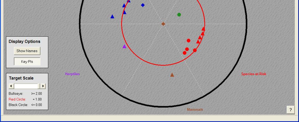
11 IERM Target Diagram
12 Plan A Net # of PIs w/ Sign nificant Gains IERM Plan Evaluation Results (Lake Ontario / Upper River 19 PIs) Historical ( ) Stochastic #1 - Wettest Century Stochastic #2 - Driest Century Stochastic #3 - Like Historical Stochastic #4 - Longest Drought -10 Plan A Plan D Plan B PreProject
13 Plan A Net # of PIs w/ Sign nificant Gains IERM Plan Evaluation Results (Entire LOSL System 32 PIs) Historical ( ) Stochastic #1 - Wettest Century Stochastic #2 - Driest Century Stochastic #3 - Like Historical Stochastic #4 - Longest Drought -10 Plan A Plan D Plan B PreProject
14 Addressing Great Lakes Withdrawal Issues Great Lakes Watershed Ecosystem Model (GLECO) Stressors Channel Modifications Other Management Actions & System Stressors Natural Hydrological & Climatological Forcings Water Use Drainage Basin Properties Flow Response Groundwater Flow Regime River Channel Flow Regime Watershed Runoff Quantity Watershed Runoff Quality Nutrient loads Solids loads Assessment Indicators Fish Population Riparian Wetland Vegetation Plant diversity Fish Habitat Weighted usable habitat area Temperature River Hydraulics Flow/Volume Depth Velocity Water Quality Nutrients Solids
15 GLECO development and application to Muskegon Watershed (MI) Configure Hydrologic Simulation Program FORTRAN (HSPF) to watershed based on geomorphic, hydrologic, land use/cover data Link HSPF to required ecological sub-models Calibrate flow and water quality parameters at various sampling locations Establish baseline condition for relevant ecological endpoints. Run model forecasts of withdrawal scenarios & compare to baseline
16 Model Scenario Application: Little Muskegon River Scenario A Single withdrawal Withdrawal of 5 MGD from the Little Muskegon River catchment #1 Scenario B : Cumulative withdrawal Withdrawal of 5 MGD from the Little Muskegon River catchment #1 & catchment #2 (10 mgd total) Withdrawals modify channel hydraulics and water temperature Withdrawals reduce suitable spawning habitat area for brown trout by 20-50%
17 Brown Trout: Spawning Habitat Suitability Functions Brown trout spawning habitat is impacted by water temperature, depth, and stream velocity. Based on U.S. Fish & 0.2 Wildlife Service brown trout 0.0 habitat report (1986). Habitat Suitability Index (HSI) Water Temperature (deg. F) Habitat Suitability Index (HSI) Stream Depth (feet) Habitat Suitability Index (HSI) Stream Velocity (ft/sec)
18 Withdrawal Scenarios for Little Muskegon River sub-basin Model generates geographic comparisons of withdrawal scenarios (red, green) relative to baseline (blue) for spawning habitat (average annual weighted suitable area): Muskegon River GW: 5 mgd GW: 5 mgd GW: 5 mgd Little Muskegon River
19 Comparison of Habitat Results Model generates temporal comparisons of scenario simulation results relative to baseline:
20 Sacramento San Joaquin Bay Delta Integrated Ecological Response Model: Concepts The Bay Delta system is managed both in terms of water quantity and water quality. There are multiple stakeholders with varying priorities Reclamation and other management and project decisions must consider ecological impacts Reclamation Project Dam Canal New flow mgmt. plan Modification of System Conditions Flow volume Velocity Temperature Salinity Ecosystem Receptor Fish Waterfowl Wetland habitat 20
21 Bay Delta Integrated Ecological Response Model: Challenges Must provide for protection and recovery of endangered and sensitive species, as well as protection and restoration of water supplies Multiple projects to consider, each may affect multiple environmental drivers Multiple ecological receptors: delta smelt, Chinook salmon, green sturgeon, riparian wetlands, migratory waterfowl, etc. Cumulative impacts may exist Must overlay management on natural hydrometeorological conditions (climate change?) 21
22 System Stressors Hydrology SJR System Operations Tributary boundary inflows, diversions, return flows DSM2-SJR Model Mathematical Mo odels Hydraulic Sub- Model (HYDRO) Predicted Vernalis Predicted Vernalis Chinook Salmon Smolt out-migration (mean flow in spring) Adult escapement (mean flow in fall) Water Quality Sub- Model (QUAL) Predicted salinity in delta area Delta Smelt Population indices: 1) SJR-Sacramento confluence 2) Suisun Bay Predicted salinity in delta area Ecological Response Sub-Models 22


23 Model Scenario Application: Little Muskegon River Little Muskegon River Watershed
Evolution of Modeling Tools to Support Management and Restoration of the Great Lakes
 NCER 2011 Conference Baltimore, MD August 1-5, 2011 Evolution of Modeling Tools to Support Management and Restoration of the Great Lakes Joseph DePinto, Todd Redder, Ed Verhamme, Tim Dekker LimnoTech Ann
CALFED Ecosystem Restoration Program (ERP)
") CALFED Ecosystem Restoration Program (ERP) The goal of the Ecosystem Restoration Program is to improve and increase aquatic and terrestrial habitats and improve ecological functions in the Bay-Delta to
CALFED Ecosystem Restoration Program (ERP) The goal of the Ecosystem Restoration Program is to improve and increase aquatic and terrestrial habitats and improve ecological functions in the Bay-Delta to
MEMORANDUM. Executive Summary. DATE: August 18, Joe DePinto, Todd Redder, Dan Rucinski
 DATE: August 18, 2009 MEMORANDUM FROM: PROJECT: TO: Joe DePinto, Todd Redder, Dan Rucinski LOIERM Sandra George, Environment Canada Kim Waltz, Wisconsin Department of Natural Resources International Upper
Pacheco Reservoir Expansion
 California Water Commission Pacheco Reservoir Expansion Unique Opportunity for Fisheries Recovery, Flood Risk Reduction and Emergency Water Supply December 13, 2017 1 of 33 Project Partners Pacheco Pass
BDCP Public Meeting. November 29, 2012
 BDCP Public Meeting November 29, 2012 BDCP Proposed Project Update and Response to Agency Comments ICF International California Department of Water Resources California Department of Fish and Game U.S.
Folsom Dam Water Control Manual Update
 Folsom Dam Water Control Manual Update Stakeholder Discussion October 31, 2013 Location: Tsakopoulos Library Galleria, East Room, 828 I Street, Sacramento US Army Corps of Engineers WELCOME & INTRODUCTIONS
What is an ecosystem?
 What is an ecosystem? An ecosystem is generally defined as a community of organisms living in a particular environment and the physical elements in that environment with which they interact. (http://www.enviroliteracy.org/category.php/3.html)
Recent Modeling in the Maumee Watershed and the Western Basin of Lake Erie
 LEMN Conference University of Windsor April 27-29, 2010 Recent Modeling in the Maumee Watershed and the Western Basin of Lake Erie J.V. DePinto, T.R. Redder, E.M. Verhamme, L. Weintraub LimnoTech, Ann
Risk and Uncertainty Assessment:
 Calibration Data: See wetland vegetation PI descriptions (by Wilcox and Ingram) for complete description of calibration data. Vegetation quadrat data (7 transects) and bathymetry/topography surveys for
Lauren Hastings, Matt Nobriga and Carl Wilcox
 Conceptual Models, Monitoring, Assessment and Performance Measures in Support of Adaptive Management in the California Bay Delta System Lauren Hastings, Matt Nobriga and Carl Wilcox CALFED Science Program
Appendix I: Fixed-400,000 af Flood Storage Operation
 Appendix I: Fixed-400,000 af Flood Storage Operation 1.0 FIXED-400,000 AF FLOOD STORAGE OPERATION This operation set provides a comparison of operations before the SAFCA/Reclamation interim agreement in
Water and Power Policy Group
 Water and Power Policy Group Retrospective Analysis of Changed Central Valley Project and State Water Project Conditions Due to Changes in Delta Regulations January 213 Retrospective Analysis January 213
California s s Water Supplies and Uses
 California s s Water Supplies and Uses Presented to Delta Stewardship Council Presented by Joe Grindstaff September 21 1 Place to Place: Most precipitation falls in the mountains in the north and east
The DNR is charged with managing waters resources to assure an adequate and sustainable supply for multiple uses.
 The DNR is charged with managing waters resources to assure an adequate and sustainable supply for multiple uses. Minnesota Laws 2015, chapter 4, article 4, directed the Department of Natural Resources
Flow-ecology relationships. Flow-ecology relationships Susitna case study
 Flow-ecology relationships Flow-ecology relationships Susitna case study Flow regime Ecologically-Relevant Flow Regime Characteristics Seasonal or typical conditions Annual extreme conditions High and
Office of the Assistant Secretary for Water and Science [RC0ZCUPCA0, 155R0680R1, RR ]
![Office of the Assistant Secretary for Water and Science [RC0ZCUPCA0, 155R0680R1, RR ]](/thumbs/85/91889528.jpg "Office of the Assistant Secretary for Water and Science [RC0ZCUPCA0, 155R0680R1, RR ]") This document is scheduled to be published in the Federal Register on 04/08/2015 and available online at http://federalregister.gov/a/2015-08035, and on FDsys.gov 4332-90-P DEPARTMENT OF THE INTERIOR Office
This document is scheduled to be published in the Federal Register on 04/08/2015 and available online at http://federalregister.gov/a/2015-08035, and on FDsys.gov 4332-90-P DEPARTMENT OF THE INTERIOR Office
Texas: Water For Wildlife. Cappy Smith
 Texas: Water For Wildlife Cappy Smith Texas water resources Understanding wildlife s connection Who owns the water? Why care? What can I do? How Wet Is Our Planet? Image Woods Hole Oceanographic Institution
Ecological Considerations in Setting MFLs and Lake Regulation Targets for the Ocklawaha Chain of Lakes
 Ecological Considerations in Setting MFLs and Lake Regulation Targets for the Ocklawaha Chain of Lakes Rolland Fulton, Ph.D. Environmental Scientist VI Bureau of Environmental Sciences St. Johns River
Estimation of rearing habitat requirements of San Joaquin River Chinook salmon using the Emigrating Salmonid Habitat Estimation (ESHE) Model
 Model") Estimation of rearing habitat requirements of San Joaquin River Chinook salmon using the Emigrating Salmonid Habitat Estimation (ESHE) Model California Central Valley Cramer Fish Sciences *Draft conceptual
Estimation of rearing habitat requirements of San Joaquin River Chinook salmon using the Emigrating Salmonid Habitat Estimation (ESHE) Model California Central Valley Cramer Fish Sciences *Draft conceptual
The Nature Conservancy Cosumnes River Preserve Franklin Boulevard Galt CA 95632
 Study Partners The Nature Conservancy Cosumnes River Preserve 13501 Franklin Boulevard Galt CA 95632 East Bay Municipal Utility District 1 Winemaker Way, Unit K Lodi CA 95240 Sacramento County Water Agency
APPENDIX A. 2-Gates Fish Protection Demonstration Project Background and Regulatory Constraints
 APPENDIX A 2-Gates Fish Protection Demonstration Project Background and Regulatory Constraints Project Background The Delta serves many functions and has many competing uses. It is a vital diversion point
Concurrent Session 129 The hydroecology of a Florida river and the potential ecological effects of human water use (Part 2 of 2)
") Concurrent Session 129 The hydroecology of a Florida river and the potential ecological effects of human water use (Part 2 of 2) Photograph: Dean Campbell Moderator: Ed Lowe, Ph. D. Director, Bureau of
Concurrent Session 129 The hydroecology of a Florida river and the potential ecological effects of human water use (Part 2 of 2) Photograph: Dean Campbell Moderator: Ed Lowe, Ph. D. Director, Bureau of
EXECUTIVE SUMMARY ES.1 BACKGROUND
 EXECUTIVE SUMMARY ES.1 BACKGROUND The San Francisco Bay/Sacramento-San Joaquin Delta Estuary (Bay/Delta Estuary) is a critically important part of California s natural environment and economy. In recognition
Ecological/Watershed Modeling. Cindy Ryals Taylor Carroll
 Ecological/Watershed Modeling Cindy Ryals Taylor Carroll Defining Models Defining the problem the question Conceptual Model a set of ideas Verbal Model translate into words Mathematical Model translate
JUVENILE SALMON MIGRATION SECTION 5. blank page
 blank page FISH AND WILDLIFE PROGRAM 5-16 September 13, 1995 SECTION 5 JUVENILE SALMON MIGRATION temperature improvement measures contained in this program will have a substantial impact on the operations
2017 Central Valley Flood Protection Plan Update: Overview
 2017 Central Valley Flood Protection Plan Update: Overview 2015 FMA Conference CVFPP Overview- Mike Mierzwa, DWR Basin-wide Feasibility Study Planning Context- Eric Tsai, DWR Technical Tools/Methodologies-
Ongoing and Completed Studies
 Attachment 2 Ongoing and Completed Studies 2014 Monitoring and Analysis Plan November 2013 Attachment 2 Ongoing and Completed Studies 1 Introduction In 2013, the small interdisciplinary study groups for
Multi-Benefit Planning in the San Joaquin River Basin-wide Feasibility Study
 Multi-Benefit Planning in the San Joaquin River Basin-wide Feasibility Study September 8 th, 2016 Presented by: Eric Tsai, P.E. California Department of Water Resources Eric.Tsai@water.ca.gov Jeremy Thomas,
Watersheds. A river is the report card for its watershed. Alan Levere. Arizona Water Issues 2010 The University of Arizona HWR203 1
 Watersheds A river is the report card for its watershed. Alan Levere 1 What separates watersheds? How do you identify watershed boundaries? Drainage Divides River Networks boto.ocean.washington.edu/gifs/purus.gif
Investigation Highlights
 Investigation Highlights May 2014 INVESTIGATION HIGHLIGHTS A Summary North-of-the-Delta Offstream Storage (NODOS) would provide a robust set of benefits, including water supply reliability for municipal
EXECUTIVE SUMMARY INTRODUCTION
 EXECUTIVE SUMMARY INTRODUCTION The Yuba River Basin drains approximately 1,339 square miles of the western Sierra Nevada slope, including portions of Sierra, Placer, Yuba, and Nevada counties. The Yuba
Current Applicant s Handbook Wetland Criteria No Harm Standards. Narrative Standard All categories. Assessment
 District 40X-2.301 Exclusions SFWMD SJRWMD harm to s or waters; harmful 1) Isolated s ½ acre or less (some caveats) 2) Wetlands be impacts by an ERP or SWM; 3) constructed waterbodies 4) s & waters that
3.4 AQUATIC ECOSYSTEMS AND FISH SPECIES
 3.4 AQUATIC ECOSYSTEMS AND FISH SPECIES The following section supplements the analysis found in Chapter Three, Section 3.4 - Aquatic Ecosystems and Fish Species of the Draft EIS on page 3.59, Impacts Related
Chehalis Basin Strategy Programmatic SEPA Draft EIS
 Chehalis Basin Strategy Programmatic SEPA Draft EIS History of Flooding I-5 closed in 1990, 1996, 2007, 2009 Five largest flood events occurred since 1986 2 History of Habitat Degradation Harvest has been
Sacramento and San Joaquin Basins Study & Climate Adaptation Options
 Sacramento and San Joaquin Basins Study & Climate Adaptation Options Presentation to MCWRA and ACWA Region 3 March 11, 2014 v2 WaterSMART Basin Study Program Overview Basin Studies Authorized in SECURE
7.0 SUMMARY AND CONCLUSIONS
 7.0 SUMMARY AND CONCLUSIONS 7.1 SUMMARY This report results from a Washington State Legislature grant to study the feasibility of storing additional water in Lake Wenatchee. The Legislature acted upon
2.1 Overview. Chapter 2 Project Objectives and Purpose and Need
 1 Chapter The BDCP sets out a comprehensive conservation strategy for the Delta designed to restore and protect ecosystem health, water supply, and water quality within a stable regulatory framework. The
SUPERSEDED. BDCP Conservation Measure 1: Water Facilities and Operation. BDCP Bay Delta Conservation Plan
 BDCP Bay Delta Conservation Plan March 2013 BDCP Conservation Measure 1: Water Facilities and Operation A cornerstone of the Bay Delta Conservation Plan (BDCP) strategy is to construct and operate a dual-conveyance
Chapter 2 Project Objectives and Purpose and Need
 Chapter Project Objectives and Purpose and Need The BDCP sets out a comprehensive conservation strategy for the Delta designed to restore and protect ecosystem health, water supply reliability, and water
GREAT LAKES WATER LEVEL REGULATIONS
 JOHN G. SHEDD AQUARIUM WHITE PAPER PROJECT 2011 GREAT LAKES WATER LEVEL REGULATIONS By: Beth Engel I. INTRODUCTION The Great Lakes Basin, storing 5,439 mi 3 of water, is comprised of the lakes and connecting
San Joaquin River Restoration Program Restoration Administrator
 San Joaquin River Restoration Program Restoration Administrator Memorandum Date: April 23, 2011 To: Ali Forsythe SJRRP Program Manager cc. Michael Jackson, Ed Salazar Doug DeFlitch, the TAC From: Rod Meade
Great Lakes Biodiversity Conservation Strategies
 A.D. Latornell Conservation Symposium Dan Kraus, Nature Conservancy of Canada 21 November 2013 Summary Two Minute History of Application and Next Steps 2 Two Minute History of the Part 1: Paradise Found
Are Juvenile Chinook Salmon Entrained at Unscreened Diversions in Direct Proportion to the Volume of Water Diverted?
 Are Juvenile Chinook Salmon Entrained at Unscreened Diversions in Direct Proportion to the Volume of Water Diverted? Charles H. Hanson Abstract Mark-recapture experiments were used to test the null hypothesis
Scenario Modeling and Restoration Implications
 Scenario Modeling and Restoration Implications Paul Kolp 1, Matt Van Ess 2, Keith Marcoe 1, Sam Geisse 2 1 Lower Columbia Estuary Partnership 2 Columbia River Estuary Study Taskforce 1 Background Estuary
Charter: Great Lakes Region Aquatic Habitat Connectivity Collaborative
 Charter: Great Lakes Region Aquatic Habitat Connectivity Collaborative Preamble Aquatic Habitat Connectivity The nature and extent of habitat connectivity is a key contributor to biodiversity conservation
G.B. Sonny Hall, PhD. Veronika Thiebach
 G.B. Sonny Hall, PhD Technical Program Manager Veronika Thiebach Senior Assistant General Counsel St. Johns River Water Management District 1 SJRWMD MFLs Method MFLs Method Premises Case studies Lake Hiawassee
2017 Lake Hartwell Association
 2017 Lake Hartwell Association By Stan Simpson Water Manager/Civil Engineer Savannah District 14 October 2017 Trusted Partners Delivering Value, Today and Tomorrow CHARLESTON JACKSONVILLE MOBILE SAVANNAH
RESPONSE TO FEBRUARY 16, 2018 REQUEST FOR ADDITIONAL INFORMATION, RESOURCE AGENCY LATE FILING, AND OTHER RELATED INFORMATION ATTACHMENT T
 RESPONSE TO FEBRUARY 16, 2018 REQUEST FOR ADDITIONAL INFORMATION, RESOURCE AGENCY LATE FILING, AND OTHER RELATED INFORMATION ATTACHMENT T DISTRICTS ANALYSIS AND COMMENT ON USFWS ATTACHMENT 5: USE OF COMULATIVE
Understanding and Restoring Natural Floodplain Function. Gary James CTUIR Fisheries Program Manager
 Understanding and Restoring Natural Floodplain Function Gary James Fisheries Program Manager Future of Our Salmon Technical Workshop on Healthy Floodplains Spokane, WA - August 16-18, 2016 Presentation
The Council Study. Sustainable Management and Development of the Mekong River Including Impacts of Mainstream Hydropower Projects
 The Council Study Sustainable Management and Development of the Mekong River Including Impacts of Mainstream Hydropower Projects Henry Manguerra, Ph.D., P.E. Study Coordinator, MRCS 4 th BDP Forum on the
PUBLIC DRAFT BAY DELTA CONSERVATION PLAN
 1 APPENDIX G BACKGROUND ON THE PROCESS OF DEVELOPING THE BDCP CONSERVATION MEASURES PUBLIC DRAFT BAY DELTA CONSERVATION PLAN 1 1 ICF International. 01. Appendix G. Background on the Process of Developing
1. PURPOSE OF AND NEED FOR ACTION
 1. PURPOSE OF AND NEED FOR ACTION INTRODUCTION The Bureau of Reclamation (Reclamation) and the San Joaquin River Group Authority (Authority) are jointly preparing this Environmental Impact Statement/Environmental
Initial Application of a Landscape Evolution Model to a Louisiana Wetland
 Initial Application of a Landscape Evolution Model to a Louisiana Wetland by Carl F. Cerco PURPOSE: Corps planning projects encompass a wide variety of restoration goals. These include wetland restoration,
8. A. AQUATIC HABITATS
 ENCLOSURE C S.R. 1006 SECTION 80S DELAWARE CANAL BRIDGE REHABILITATION PROJECT, TINICUM TOWNSHIP, BUCKS COUNTY, PENNSYLVANIA DESCRIPTION OF AQUATIC HABITAT 8. A. AQUATIC HABITATS (1) Food Chain Production-
SACOG Board of Directors
 SACOG Board of Directors Item #15-4-7 Consent April 9, 2015 Approve Support for H.R. 1060 (Sacramento Valley Water Storage and Restoration Act of 2015) Issue: Should SACOG support H.R. 1060, the Sacramento
Instream Flow Protection Efforts in Pennsylvania
 Instream Flow Protection Efforts in Pennsylvania Leroy M. Young Pennsylvania Fish and Boat Commission Glossary Instream use - any use of water that does not require a diversion or withdrawal from the original
Climate Change and Great Lakes Natural Systems. Climate Change and Water in the Great Lakes Region, ARC Webinar October 21, 2008
 Climate Change and Great Lakes Natural Systems Linda Mortsch Adaptation and Impacts Research Division, Environment Canada Climate Change and Water in the Great Lakes Region, ARC Webinar October 21, 2008
EXHIBIT ARWA-500 PART 2 TESTIMONY OF TOM GOHRING, P.E.
 EXHIBIT ARWA-500 PART 2 TESTIMONY OF TOM GOHRING, P.E. 1. I am the Executive Director of the Water Forum. I hold a Bachelor of Science degree in Agricultural Engineering from the California Polytechnic
Mokelumne River Joint Settlement Agreement: From litigation to collaboration to success. Jose Setka EBMUD Fisheries & Wildlife Division
 Mokelumne River Joint Settlement Agreement: From litigation to collaboration to success Jose Setka EBMUD Fisheries & Wildlife Division Objectives Lead up to litigation Settlement and collaboration Implementation
TABLE OF CONTENTS: VOLUME 1
 Page i TABLE OF CONTENTS: VOLUME 1 Clallam County Resolution No. 47, 2005, Approving the Plan Acknowledgements Planning Unit Signatures and Initiating Government Letters of Approval TABLE OF CONTENTS...
Brannen Lake Storage Feasibility Potential Effects on Water Levels
 Brannen Lake Storage Feasibility Potential Effects on Water Levels Brannen Lake Storage Feasibility Potential Effects on Water Levels Prepared for: BC Conservation Foundation #3, 1200 Princess Royal Avenue
EUROPE AND NORTH AMERICA. 14. Everglades National Park (United States of America) (N 76)
 (N 76)") EUROPE AND NORTH AMERICA 14. Everglades National Park (United States of America) (N 76) Year of inscription on the World Heritage List 1979 Criteria (viii) (ix) (x) Year(s) of inscription on the List of
EUROPE AND NORTH AMERICA 14. Everglades National Park (United States of America) (N 76) Year of inscription on the World Heritage List 1979 Criteria (viii) (ix) (x) Year(s) of inscription on the List of
Fort McKay Specific Assessment
 SURFACE WATER HYDROLOGY Fort McKay Specific Assessment Fort McKay Industry Relations Corporation March 2010 Contents 4.0... 1 4.1 Fort McKay s Key Concerns Related to Surface Water... 1 4.2 Fort McKay
Napa Watershed Symposium. Factors affecting future water quantity and quality in Napa County, and strategies for adaptation
 Napa Watershed Symposium Factors affecting future water quantity and quality in Napa County, and strategies for adaptation Pierre Stephens California Department of Water Resources May 21, 2009 Source:
SHORELINE INVENTORY AND RESTORATION PLANNING
 CHAPTER 3 SHORELINE INVENTORY AND RESTORATION PLANNING A. PURPOSE OF THE SHORELINE INVENTORY AND CHARACTERIZATION A first step in the comprehensive Master Program update process is development of a shoreline
OVERVIEW OF RESERVOIR OPERATIONS AND FLOOD RISK MANAGEMENT
 OVERVIEW OF RESERVOIR OPERATIONS AND FLOOD RISK MANAGEMENT 255 255 255 237 237 237 0 0 0 217 217 217 163 163 163 200 200 200 COLUMBIA RIVER BASIN 131 132 122 239 65 53 80 119 27 110 135 120 252 174.59
Cedar River Watershed Habitat Conservation Plan
 Cedar River Watershed Habitat Conservation Plan Briefing for the WRIA 8 Salmon Recovery Council November 21, 2013 Cyndy Holtz Seattle Public Utilities cyndy.holtz@seattle.gov What is an HCP? Habitat Conservation
Appendix B. Operations on the Columbia River - Relationship between Columbia River Treaty, Non Treaty Storage Agreement, and Water Use Plans
 Appendix B Operations on the Columbia River - Relationship between Columbia River Treaty, Non Treaty Storage Agreement, and Water Use Plans The actual physical operations on the Columbia River are a result
Tim Hayden, Yurok Tribe Natural Resources Division Mat Millenbach, Western Rivers Conservancy Sarah Beesley, Yurok Tribal Fisheries Program
 BLUE CREEK FOREST SANCTUARY: RESTORING OLD GROWTH FOREST ECOSYSTEM FUNCTION, PROTECTING SALMON, WILDLIFE, AND TRADITIONAL- LIFE WAYS AND CULTURE IN THE FACE OF CLIMATE CHANGE Tim Hayden, Yurok Tribe Natural
Water and Watersheds. Data Maps Action
 Water and Watersheds Data Maps Action What is the Wildlife Action Plan? Restore rare wildlife and habitats. Keep common species common. 2015 Revision: Partners in Conservation Science 2015 Revision Data
The following potential environmental receptors and impacts form the basis of TRCA s review under Ontario Regulation 166/06 and the Fisheries Act:
 TRCA Technical Guidelines for the Development of Environmental Management Plans for Dewatering September 2013 Rationale: The Technical Guidelines for the Development of Environmental Management Plans for
In This Issue. Overview. What is the Lake Ontario LAMP? Overview... 1 Basin Map... 1 Accomplishments... 2 Addressing Challenges...
 In This Issue Overview... 1 Basin Map... 1 Accomplishments... 2 Addressing Challenges... 3 What is the Lake Ontario LAMP? Under the Great Lakes Water Quality Agreement (GLWQA), the governments of Canada
ASWM Annual Meeting March 30, 2016 NCTC, Shepherdstown, WV. Andrew Robertson, Director
 ASWM Annual Meeting March 30, 2016 NCTC, Shepherdstown, WV Andrew Robertson, Director aroberts@smumn.edu Location Within Northern Wisconsin Watershed Characteristics Approximately 139,000 acres or 220
Climate Data Training Session April 26, 2017 Ontario Science Centre
 Adaptive Management To Address Climate Change Uncertainty in EA Process A Case Study of the Don Mouth Naturalization and Port Lands Flood Protection Project EA (DMNP EA) Climate Data Training Session April
LIST OF TECHNICAL APPENDICES
 Idaho Power Company List of Technical Appendices LIST OF TECHNICAL APPENDICES Sediment and Geomorphology E.1-1 Sediment Transport, Supply, and Stability in the Hells Canyon Reach of the Snake River This
Climate Change: Impacts, Monitoring, and Solutions
 Climate Change: Impacts, Monitoring, and Solutions 1 Responding to Climate Change 1. Projections/Impacts 2. Adaptation and Resiliency 3. Monitoring 4. What about emissions? 2 Native trout and salmon are
It's tough to make predictions, especially about the future. Ecological response models: part 1 - overview
 Ecological response models: part 1 - overview Approaches to vulnerability assessment It's tough to make predictions, especially about the future. Judicious use of model projections at appropriate scales
FRANKS TRACT PILOT PROJECT Summary Paper March 19, 2007
 FRANKS TRACT PILOT PROJECT Summary Paper March 19, 2007 DRAFT2 Introduction[1] The Flooded Islands Pre-Feasibility Study Report identified several project alternatives to alter the Delta hydrodynamics
The following potential environmental receptors and impacts form the basis of TRCA s review under Ontario Regulation 166/06 and the Fisheries Act:
 Interim TRCA Technical Guidelines for the Development of Environmental Management Plans for Dewatering September 2013 Rationale: The Technical Guidelines for the Development of Environmental Management
Flood Protection Meets Climate Change
 Flood Protection Meets Climate Change Robin Grossinger, San Francisco Estuary Institute, robin@sfei.org Scott Dusterhoff, San Francisco Estuary Institute Julie Beagle, San Francisco Estuary Institute Climate
A PILOT STUDY FOR ASSESSING FRESHWATER FLOW IMPACTS TO LOUISIANA ESTUARIES
 A PILOT STUDY FOR ASSESSING FRESHWATER FLOW IMPACTS TO LOUISIANA ESTUARIES Ryan Clark, Melissa Baustian, Eric White, Yushi Wang, Andrea Jerabek, and Harris Bienn Louisiana Water Conference March 27, 2018
Appendix 5G Comparison of FEIRS Alternative 4A Modeling Results to the California Water Fix Section BA Proposed Action Modeling Results
 Appendix G Comparison of FEIRS Alternative A Modeling Results to the California Water Fix Section BA Proposed Action Modeling Results 6 7 8 9 0 6 7 8 9 0 6 7 8 9 0 6 7 Appendix G Comparison of FEIRS Alternative
Implications of Climate Change on Fish Passage and Reintroduction. Future of Our Salmon Conference. April 23, Bob Heinith Heinith Consulting
 Implications of Climate Change on Fish Passage and Reintroduction Future of Our Salmon Conference April 23, 2014 Bob Heinith Heinith Consulting Outline Understanding Climate Change Defining Fish Vulnerability
Report. Environmental Water Demands. Butte County Department of Water and Resource Conservation Integrated Water Resources Plan.
 Report Butte County Department of Water and Resource Conservation Integrated Water Resources Plan s June 2004 s Section 1 - Introduction 1.1 Project Description This project is a preliminary investigation
Chapter 2 Problems, Needs, and Opportunities
 Chapter 2 Problems, Needs, and Opportunities This chapter discusses specific water resources problems, needs, and opportunities that are used to direct the development of the NODOS/Sites Reservoir Project
TRUCKEE BASIN STUDY. Reclamation Mid-Pacific Region. Truckee Meadows Water Authority. April 15, 2015 Reno, NV BOARD Agenda Item 6
 TRUCKEE BASIN STUDY Reclamation Mid-Pacific Region Truckee Meadows Water Authority April 15, 2015 Reno, NV x Page 1 of 22 Basin Studies - Mandated Elements P.L. 111-11 The SecureWater Act: Each Basin Study
Session 117 The hydroecology of a Florida river and the potential ecological effects of human water use (Part 1 of 2)
") Session 117 The hydroecology of a Florida river and the potential ecological effects of human water use (Part 1 of 2) Moderator: Ed Lowe, Ph. D. Director, Bureau of Environmental Sciences St. Johns River
Session 117 The hydroecology of a Florida river and the potential ecological effects of human water use (Part 1 of 2) Moderator: Ed Lowe, Ph. D. Director, Bureau of Environmental Sciences St. Johns River
RECORD OF DECISION MISSOURI RIVER MASTER WATER CONTROL MANUAL REVIEW AND UPDATE
 RECORD OF DECISION MISSOURI RIVER MASTER WATER CONTROL MANUAL REVIEW AND UPDATE I have reviewed the Missouri River Master Water Control Manual Review and Update Final Environmental Impact Statement (FEIS),
Meacham Creek Fish Habitat Enhancement: Application of the CTUIR River Vision
 Meacham Creek Fish Habitat Enhancement: Application of the CTUIR River Vision Future of Our Salmon A Vision of Restoration in the Columbia River Basin June 1, 2011 James Webster Confederated Tribes of
Reorienting the Bureau of Reclamation
 Reorienting the Bureau of Reclamation Eric Meyer When considering restoration programs, The United States Bureau of Reclamation (USBR) is not a typical restoration agency. The USBR has existed for nearly
Cumulative Effects Monitoring: Lessons Learned from Development Monitoring in the Grand River. Latornell November
 Cumulative Effects Monitoring: Lessons Learned from Development Monitoring in the Grand River Latornell November 21 2017 Outline 1. Introduce the Project; Background on Blair Creek 2. Objectives 3. Cumulative
Water Supply Board Briefing. Water Operations Department March 22, 2016
 Water Supply Board Briefing Water Operations Department March 22, 2016 Water Supply Briefing California Water Supply District Water Supply Water Supply Projections Water Supply Schedule 2 California Water
Surface Water. Solutions for a better world
 1 Surface Water Solutions for a better world Our Surface Water Services Expertise Growing worldwide awareness of water scarcity has encouraged water preservation programs, better irrigation techniques
RAINY AND NAMAKAN LAKES RULE CURVES REVIEW
 RAINY AND NAMAKAN LAKES RULE CURVES REVIEW STUDY STRATEGY Submitted to: International Joint Commission Submitted by: International Rainy and Namakan Lakes Rule Curves Study Board February 10, 2016 Table
The Instream Flow Incremental Methodology
 The Instream Flow Incremental Methodology Introduction to IFIM Scientific support for complex management decisions involving water use and impacts to aquatic systems requires a better understanding of
2019 Funding Opportunity Guidance for Applicants
 2019 Funding Opportunity Guidance for Applicants Webinar Agenda Sustain Our Great Lakes overview Funding opportunity details Application guidance Q&A session Housekeeping: o Q&A breaks o Webinar recording/slides
Cat Island Chain Restoration, Green Bay
 Cat Island Chain Restoration, Green Bay Victoria Harris, UW Sea Grant January 27, 2005 Southern Green Bay historically provided diverse coastal wetland habitats for fish and wildlife Expansive emergent
Bay of Plenty Regional Water and Land Plan
 Operative Bay of Plenty Regional Water and Land Plan Working with our communities for a better environment E mahi ngatahi e pai ake ai te taiao Bay of Plenty Regional Water and Land Plan Update Record
Progress and Perspectives in Mexico - US Join Cooperative Actions on the Colorado River, with Drought and Climate Change
 Navigating the Future of the Colorado River Progress and Perspectives in Mexico - US Join Cooperative Actions on the Colorado River, with Drought and Climate Change Ing. Mario López Pérez Comisión Nacional
Section V: Water Accounting and Water Supply Reliability
 Section V: Water Accounting and Water Reliability A. Quantifying the Water Supplier s Water Supplies 1. Agricultural Water Supplier Water Quantities Table 41 shows typical water diversions from the CA