Forest Applications. Christiana Schmullius. 2 July 2009
|
|
|
- Nancy Lucas
- 6 years ago
- Views:
Transcription
1 Forest Applications Christiana Schmullius 2 July 29
2 Contents Motivation Need for Biomass Mapping Biomass Components Physical Background Wavelength Polarisation Coherence Mapping Results Siberia: Coherence Regression Model China: Coherence Interferometric Water Cloud Model Canada: Hyper-temporal Radar Regression Model Polarimetry SRTM/X-SAR
3
4 Einführung mit C/X-Äthna-Beispielen MFFU Sommerschule 2

5

6 Volume scattering
7
8 Scattering Profile (pine): Most scattering comes from upper canopy (X-band) if there are no gaps.
9 AIRSAR (NASA/JPL) polarimetric C-, L- and P-Band with Incidence Angles of 4 and 5 only true for mono-temporal acquisitions! IMHOFF 1995: 514

 ERS")
10 JERS (good contrast forest/open areas) ERS (almost no contrast)

11 IS2 IS7 ASAR AP, Siberia
12 Improvement: Multi-temporal combination ERS Tandem Coherence RMSE: 1 m 3 /ha Relative RMSE: 7 % JERS Backscatter RMSE: 33 m 3 /ha, Relative RMSE: 22 % Santoro et al., RSE, 22
13 Dual-Pass vs. Single-Pass interferometry [MFFU Sommerschule 2]


14 Phase Representation Phase is always ambiguous w.r.t. integer multiples of 2π phase unwrapping required! pictorial representation of phase: grey value color wheel [MFFU Sommerschule 2]

15 Interferometric phase Bachu, China approx. 1 km 8 km [Bamler, R., InSAR Sommerschule 22]

16 Coherence Examples γ =,28 γ =, 5 γ =, 65 γ =, 82 [MFFU Sommerschule 2]


17 Co-registered Forest-GIS Polygons
18 Model definition for coherence γ v Vγ () v γ + ( γ γ ) e = γ γ 75 γ = a + b γ γ γ 75 γ ( v) Vγ ( a + ( b 1 γ ) e = γ 75 + γ γ ) ( ) e γ ( v) = γ γ v= growing stock volume γ = coherence at v = m 3 /ha (non-forest) γ = coherence for asymptotic values of v (corresponding to dense forest) γ 75 = value where the coherence distribution reach 75% of the maximum value (see fig.) 75 V γ = characteristic v value where the exponential function has decreased by e -1 Wagner et al., RSE, 23 v v


19 Classification chain ERS coherence image JERS intensity image Use model to calculate class means Maximum Likelihood Classifier Iterated Contextual Probability Classifier (ICP)


20 Mapping Results Siberia Separability of classes


21 Automatic Adaptive Consistent Validated

22

23


24 Forest DRAGON Project Areas
25 Backscatter model A B C D Water cloud Water cloud with gaps A water cloud with gaps is closer to reality and easy to handle σ o for o βv o = σgre + σveg 1 ( βv e ) Ground backscatter Forest transmissivity Vegetation backscatter Forest transmissivity is related to canopy closure and tree attenuation
26 Interferometric Water Cloud Model Forest coherence is the sum of ground coherence temporal decorrelation canopy coherence temporal and volume decorrelation γ for σ gr σ βv ( V ) = γ gr e + γ veg σ σ for veg for βv ( 1 e )* γ ( h, Bn, α ) vol Ground contribution Vegetation contribution σ o for o βv o = σ gre + σ veg 1 βv ( e ) γ gr and σ gr represent ground temporal coherence and backscatter γ veg and σ veg represent vegetation temporal coherence and backscatter β is related to the forest transmissivity (~ for ERS) Volume decorrelation related to h, Height allometric equation to express it as a function of stem volume B n, perpendicular baseline α, two-way tree attenuation 1 2 db/m depending on season (Askne et al. 1997)
27 Stem volume retrieval procedure 1. Model training 2. Inversion using a test set Retrieval statistics RMSE = 65.6 m 3 /ha Relative RMSE = 29 % R 2 =.59
28 2. Testing Invert the model using backscatter and/or coherence values to estimate stem volume. Error 1. ERS backscatter does not provide any information 2. JERS backscatter provides rather good results Dry-unfrozen conditions Winter-frozen conditions / weather changes 3. ERS tandem coherence provides best results Accuracy depends on 6 % 45 % 3 % Local survey 15 % 1) weather conditions, 2) inventory unit Santoro et al., RSE, 22
29 Temporal and spatial consistency of the coherence How much does the coherence depend upon time and space? Frozen weather conditions Properties of winter coherence: highest ground coherence, highest sensitivity to stem volume Best conditions for retrieval! Why are there different trends? What about the spread? External source: different environmental conditions Intrinsic source: forest stand structure (= homogeneity) Ground data accuracy

30 Forest structure / Quality of inventory data r = r = RS > 5 % Area > 3 ha r = RS > 3 % Area > 3 ha r = Failed update of inventory data (Santoro et al. 27)
![Stem Density [/ha]](/docs-images/79/79376354/images/31-2.jpg "5 4 3 2 1 Chunsky")

=-1.")

31 Stem Density [/ha] Chunsky and Bolshe DBH [cm] Stem Density [/ha] log r=-.993 r=-.989 ln(n)=-1.621*ln(dbh) DBH [cm] log
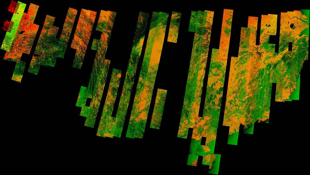
 B: Sigma nought ratio 223 Coherence images (acquired in all seasons) Baselines: - 4 m Largest area yet mapped with SAR")
32 ERS-1/2 Dataset Problem: How to train a semi-empirical model for 223 ERS-1/2 images without Mosaic Ground-truth data R: Coherence G: Sigma nought (ERS-1) B: Sigma nought ratio 223 Coherence images (acquired in all seasons) Baselines: - 4 m Largest area yet mapped with SAR techniques

33 Chinese test sites High RS forests
 provides global sub-pixel")
. Why is VCF important in this context?")
34 Training of IWCM using VCF What is VCF? The Modis Vegetation Continuous Field product (VCF) provides global sub-pixel estimates of landscape components (tree cover, herbaceous cover and bare cover) at 5 m pixel size (Hanson et al. 22). Why is VCF important in this context? Because coherence and VCF contain similar information
35 Regression vs. VCF Dashed line- regression Solid line - VCF
36 Temporal decorrelation
37 Forest transmissivity β β [ha/m 3 ] Dec Jan Jan 1-2 Jan 9-1 Oct Sep Sep Oct May25-26 Sep May Regression-based estimation of all 5 unknowns.
38 Regression- vs. VCF-based model training Coherence 1.5 Chunsky N 29-3 Dec. 95 Intensity [db] -5-1 Coherence 1.5 Bolshe NE Sep. 97 Intensity [db] -5-1 Dashed line- regression Solid line - VCF Stem volume [m 3 /ha] Chunsky N Jan Stem volume [m 3 /ha] Stem volume [m 3 /ha] Bolshe NE Oct Stem volume [m 3 /ha] Coherence.5 Intensity [db] -5-1 Coherence.5 Intensity [db] Stem volume [m 3 /ha] Chunsky E Jan Stem volume [m 3 /ha] Stem volume [m 3 /ha] Bolshe NE Sep Stem volume [m 3 /ha] Coherence.5 Intensity [db] -5-1 Coherence.5 Intensity [db] Stem volume [m 3 /ha] Bolshe NE 1-2 Jan Stem volume [m 3 /ha] Stem volume [m 3 /ha] Bolshe NW Sep Stem volume [m 3 /ha] Coherence.5 Intensity [db] -5-1 Coherence.5 Intensity [db] Stem volume [m 3 /ha] Primorsky E 9-1 Oct Stem volume [m 3 /ha] Stem volume [m 3 /ha] Bolshe NW May Stem volume [m 3 /ha] Coherence.5 Intensity [db] -5-1 Coherence.5 Intensity [db] Stem volume [m 3 /ha] Stem volume [m 3 /ha] Stem volume [m 3 /ha] Stem volume [m 3 /ha]


39 Variability of coherence within frames Variability of ground coherence Variability of dense canopies Sandy soils, Peat soils
40 Variability of coherence within frames 1 γ gr & γ veg -6 σ gr & σ veg [db] Training for the whole frame VCF Training.5 VCF Training FID Training FID Training 1 γ gr & γ veg -6 σ gr & σ veg Restricted VCF Training.5 VCF Training FID Training FID Training

41 Classification accuracy Classes according to the SIBERIA map: 1-2,2-5,5-8,>8 m^3/ha Test site & image κ All Unfrozen Frozen SD Accuracy [%] >8 [m 3 /ha] SD Overall Acc. [%] kappa Chunsky N 29-3 Dec Chunsky E Jan Bolshe NE Sep Green: VCF-based training Red: Regression-based training Bolshe NW Sep

42 Forest Map of Northeast China ESA DRAGON Project and ERS-coherence
43 ERS-1/2 tandem dataset for South China ~ 5 ERS-1/2 image pairs with baseline < 4 m and high quality One main acquisition phase: November 1995 June 1996 (descending) No further large-scale acquisition after 1996 as for Northeast China Almost full coverage, some multi-temporal tracks (up to 4 coherence images) Lijiang
44 Bn [m] South China baseline and temporal decorrelation pre-analysis South China - ERS-1/2 tandem Perpendicular baseline (B n ) Long (at the limit) in December - January Short (optimal) in February May Temporal decorrelation = coherence contrast High contrast until beginning of May In May different results (rain season starts) 2-3 Mar Jan Mar 96
45

46 China Growing Stock Volume Map Courtesy ESA DRAGON Project (Cartus, Santoro)

47 (Frank De Grandi & Ake Rosenqvist)
48 ALOS-PALSAR DATA 1. L band SAR, HH, VV, HV and full polarimetry, multiple incidence Resolution: 25 m, 15 m Swath width: 1 km, 4 km Temporal coverage: 46 days nominal 2. Observation over N. Eurasia: consistent coverage in the frame of the Kyoto and Carbon Initiative Ake Rosenqvist <ake.rosenqvist@jrc.it> 3. Data: available from 4. Products for N. Eurasia from the K&C initiative. Land Use, Biomass Wetland, ARD, Freeze/thaw Contact: Ake.Rosenqvist@jrc.it
49 Chunsky North Regression Analysis Stem volume vs. Coherence (5feb28-22mar28) 12.5 m data Stem volume vs. backscatter (HV) (5aug27) 12.5 m data Very significant correlation between SAR data and stem volume!


50 Chunsky North Biomass map m³/ha 3 m³/ha > 3 m³/ha N N IWC Model Results Good values for RMSE and R² at polygon level! Resolution 12,5 m. Be aware of the RMSE of the ground data

51 Courtesy ESA GSE FM, C.+C.Thiel

52

53 Current research: ENVISAT ASAR Global Mode Courtesy A. Bartsch, IPF, TU Wien


54 ENVISAT ASAR Wide Swath dataset During 23 and 24 ENVISAT ASAR data in Wide Swath mode has been acquired over the study area of the SIBERIA-II Project Several hundred ASAR scenes have been acquired, with a high degree of overlap between neighboring tracks The point was imaged 97 times during 23-24

55 Growing stock volume maps WS-based Forest inventory


56 Multitemporal observation using ASAR Wide Swath Santoro, 27) (Courtesy of Maurizio Modeling Inversion A multi-temporal combination of single estimates with weights determined by the backscatter contrast σ veg - σ gr allows obtaining the final estimate

57 Single-image Multi-temporal (29 images) Inventory From a single image it is possible to identify sparse/dense forest patterns at most From multi-temporal combination it is possible to identify biomass levels
58 Chunsky, Siberia Inventory data 1m 15m 2m 25m VCF tree cover [%] VCF=( e+6*Volume).21 VCF tree cover [%] VCF=(3458*Volume).24 VCF tree cover [%] VCF=(677.4*Volume).26 VCF tree cover [%] VCF=( *Volume).25 1 R 2 = R 2 = R 2 = R 2 = Stem volume [m 3 /ha] Stem volume [m 3 /ha] Stem volume [m 3 /ha] Stem volume [m 3 /ha] Courtesy ESA BIOMASAR Project (Cartus, Santoro)

59 Canada Growing Stock Volume Map Landsat IR-Composite ENVISAT WideSwath (hyper-temp.) GSV map
60 Spaceborne SARs Satellite Agency Frequency - Polarisation Resolution - Swath JERS JAXA L-HH 25m 1 km ERS-1 ERS ESA C - VV 25 m 1 km RADARSAT CSA C - HH 1-1 m 45-5 km ENVISAT - ASAR ALOS - PALSAR 22 ESA C - HH/VV/HV 25-1 m 5-5 km 26 JAXA L - Polarimetric 1-1 m 1-35 TerraSAR-X 26 -> DLR X - Polarimetric km 1 16 m 5 1 km Special 35 incidence Interferometry ( ERS-1/2) Multi-incidence Multi-incidence Multi-incidence Multi-incidence and SRTM/X-SAR

61 Polarimetry Pauli Decomposition with ALOS Data: S HH + S VV S HH S VV 2S HV Surface Scattering Double Bounce Volume Scattering


62 Backscatter Mechanisms in a Forest Canopy LE TOAN et al. 21: 4
63 Trennbarkeitsanalyse (Jeffries Matusita) Slide 16/17 Freeman Dekomposition Forest Clear Cut Forest Burn Scar Clear Cut Burn Scar HV,747,571,27 HV tn,767,559,31 Entropy,789,57,431 Alpha,794,51,464 Freeman P VOL,953,812,457 Freeman P DBL,53,39,257 Freeman P ODD,511,318,284 2, 1,8 1,6 1,4 1,2 1,,8,6,4,2, 1 Forest 2 Clear Cut 3 Burn Scar Freeman P VOL

64

65 ERS-1/2 tandem coherence


66 Coherence ASAR-IMS HH April/Mai Thüringen April/August Thüringen


67 Weather effects Strong decorrelation occurs with rainfall
 [Strozzi, InSAR Sommerschule")
68 Temporal Decorrelation ERS tandem (1 day) ERS long-term (35 days) [Strozzi, InSAR Sommerschule 22]
69 Major Conclusions The new VCF-based classification approach is a fast and easy method to map forest stem volume. Algorithm was successfully applied to boreal, temperate and subtropical environments. Open issues due to unavailability of ground truth: 1) Assumed low accuracy of intermediate classes (2-5,5-8 m 3 /ha) based on Siberian field data. 2) Siberian boreal forest Chinese cold-temperate forests: Are there differences in coherence?
Radar Polarimetry for Forestry Applications: ALOS and Radarsat-2 studies in Canada
 Radar Polarimetry for Forestry Applications: ALOS and Radarsat-2 studies in Canada by S. R. Cloude (1), A. Marino (2), D. Goodenough (3), H Chen (3), A. Richardson (3), B. Moa (4) (1) AEL Consultants,
Product Delivery Report for K&C Phase 2. Christian Thiel Friedrich-Schiller-University Jena
 Product Delivery Report for K&C Phase 2 Christian Thiel Friedrich-Schiller-University Jena Science Team meeting #15 JAXA TKSC/RESTEC HQ, Tsukuba/Tokyo, January 24-28, 2011 1. Published (please provide
The Biomass mission How it works, what it measures? Thuy Le Toan, CESBIO, Toulouse, France & The Biomass Mission Advisory Group
 The Biomass mission How it works, what it measures? Thuy Le Toan, CESBIO, Toulouse, France & The Biomass Mission Advisory Group Why Synthetic Aperture Radars to observe the world forests? Transmit and
Forest Changes and Biomass Estimation
 Forest Changes and Biomass Estimation Project Title: Comparative Studies on Carbon Dynamics in Disturbed Forest Ecosystems: Eastern Russia and Northeastern China Supported by NASA Carbon Cycle Science
AGRICULTURAL PERFORMANCE MONITORING WITH POLARIMETRIC SAR AND OPTICAL IMAGERY
 AGRICULTURAL PERFORMANCE MONITORING WITH POLARIMETRIC SAR AND OPTICAL IMAGERY Tishampati Dhar [1][2], Doug Gray [1], Carl Menges [2] [1] Dept of Electrical and Electronic Engineering, University of Adelaide,
Polar Space Task Group Permafrost Review of Requirements, Achievements and Expected Data
 Polar Permafrost Review of Requirements, Achievements and Expected Data Annett Bartsch Central Institute for Meteorology and Geodynamics, Vienna, Austria PSTG 6, ESTEC, Sept., 2016 Developments since last
K&C Science Report Phase 1 Change in forest cover in Central Siberia using ALOS/PALSAR
 K&C Science Report Phase 1 Change in forest cover in Central Siberia using ALOS/PALSAR Thuy Le Toan Centre d Etudes Spatiales de la Biosphère 18 Avenue Edouard Belin, 31401 Toulouse Cedex 9, France Thuy.Letoan@cesbio.cnes.fr
Rice crop monitoring using EO data in the Mekong Delta, Vietnam
 The 10th GEOSS Asia-Pacific Symposium WG5: Agriculture and Food Security Hanoi, 18-20 th, Sep. 2017 Rice crop monitoring using EO data in the Mekong Delta, Vietnam Lam Dao Nguyen, Hoang Phi Phung, Dang
Large-Scale Mapping of Boreal Forest in SIBERIA using ERS Tandem Coherence and JERS Backscatter Data
 Large-Scale Mapping of Boreal Forest in SIBERIA using ERS Tandem Coherence and JERS Backscatter Data Wolfgang Wagner 1, Adrian Luckman 2, Jan Vietmeier 1, Kevin Tansey 2, Heiko Balzter 3, Christiane Schmullius
Global Biomass Map Products
 Global Biomass Map Products Maurizio Santoro (santoro@gamma-rs.ch) & GlobBiomass team Status of global biomass datasets at UW3 A first version of the global AGB and GSV datasets were delivered to ESA and
THE SIBERIA-II PROJECT AS SEEN BY ENVISAT ASAR
 THE SIBERIA-II PROJECT AS SEEN BY ENVISAT ASAR Maurizio Santoro (1), Christiane Schmullius (1), Heiko Balzter (2), Annett Bartsch (3), Manuela Grippa (4), Richard Kidd (3), Thuy Le Toan (4), Julien L'Hermitte
IEEE TRANSACTIONS ON GEOSCIENCE AND REMOTE SENSING 1
 IEEE TRANSACTIONS ON GEOSCIENCE AND REMOTE SENSING 1 TanDEM-X Pol-InSAR Performance for Forest Height Estimation Florian Kugler, Daniel Schulze, Irena Hajnsek, Fellow, IEEE, Hans Pretzsch, and Konstantinos
FOREST AND FOREST CHANGE MAPPING WITH C- AND L-BAND SAR IN LIWALE, TANZANIA
 FOREST AND FOREST CHANGE MAPPING WITH C- AND L-BAND SAR IN LIWALE, TANZANIA J. Haarpaintner a, C. Davids a, H. Hindberg a, E. Zahabu b, R.E. Malimbwi b a Norut, P.O. Box 6434, Tromsø Science Park, N-9294
Integration methods for forest degradation assessment and change monitoring
 VTT TECHNICAL RESEARCH CENTRE OF FINLAND LTD Joint GFOI / GOFC-GOLD / CONABIO / SilvaCarbon R&D Expert and Capacity Building workshop on: Regional solutions to forest type stratification and characterising
Remote sensing as a tool to detect and quantify vegetation properties in tropical forest-savanna transitions Edward Mitchard (University of Edinburgh)
") Remote sensing as a tool to detect and quantify vegetation properties in tropical forest-savanna transitions Edward Mitchard (University of Edinburgh) Presentation to Geography EUBAP 10 th Oct 2008 Supervisor:
Remote sensing as a tool to detect and quantify vegetation properties in tropical forest-savanna transitions Edward Mitchard (University of Edinburgh) Presentation to Geography EUBAP 10 th Oct 2008 Supervisor:
MONITORING OF CROP GROWTH AND SOIL MOISTURE RETRIEVAL USING NISAR DATA. HARI SHANKER SRIVASTAVA Indian Institute of Remote Sensing (IIRS),
,") NISAR Science Workshop 2015 Space Applications Centre MONITORING OF CROP GROWTH AND SOIL MOISTURE RETRIEVAL USING NISAR DATA HARI SHANKER SRIVASTAVA Indian Institute of Remote Sensing (IIRS), Indian Space
NISAR Science Workshop 2015 Space Applications Centre MONITORING OF CROP GROWTH AND SOIL MOISTURE RETRIEVAL USING NISAR DATA HARI SHANKER SRIVASTAVA Indian Institute of Remote Sensing (IIRS), Indian Space
The BIOMASS mission An ESA Earth Explorer candidate to measure the BIOMASS of the earth's forests
 Downloaded from orbit.dtu.dk on: May 08, 2018 The BIOMASS mission An ESA Earth Explorer candidate to measure the BIOMASS of the earth's forests Scipal, K.; Arcioni, M.; Chave, J.; Dall, Jørgen; Fois, F.;
SAR data for forestry and agriculture
 SAR data for forestry and agriculture Thuy Le Toan September 5, 2007 Lecture D3L3 Assets of radar data for vegetation monitoring? All weather capability to secure data acquisition during growing season
APPLICATION OF POLSAR FOR TROPICAL TIMBER PLANTATION IN INDONESIA
 APPLICATION OF POLSAR FOR TROPICAL TIMBER PLANTATION IN INDONESIA M. A. Raimadoya (1) and B.H. Trisasongko (1) (1) Radar Analysis Working Group (RAWG), Department of Soil Sciences & Land Resources, Bogor
3/1/18 USING RADAR FOR WETLAND MAPPING IMPORTANCE OF SOIL MOISTURE TRADITIONAL METHODS TO MEASURE SOIL MOISTURE. Feel method Electrical resistance
 3/1/18 USING RADAR FOR WETLAND MAPPING SOIL MOISTURE AND WETLAND CLASSIFICATION Slides modified from a presentation by Charlotte Gabrielsen for this class. Southeast Arizona: Winter wet period From C.
DLR contributions to R&D Support strategy (Element 3) Status update. Michael Bock, Helmut Staudenrausch SDCG-12 Session 4
 Status update. Michael Bock, Helmut Staudenrausch SDCG-12 Session 4") DLR contributions to R&D Support strategy (Element 3) Status update Michael Bock, Helmut Staudenrausch SDCG-12 Session 4 SDCG-12 Frascati September 5-7, 2017 TerraSAR/TanDEM-X Mission Status Satellite
DLR contributions to R&D Support strategy (Element 3) Status update Michael Bock, Helmut Staudenrausch SDCG-12 Session 4 SDCG-12 Frascati September 5-7, 2017 TerraSAR/TanDEM-X Mission Status Satellite
Integration of SAR multi-frequency and optical data for the retrieval of soil moisture and vegetation water content
 Integration of SAR multi-frequency and optical data for the retrieval of soil moisture and vegetation water content A. Padovano 1,2, F. Greifeneder 1, R. Colombo 2, G. Cuozzo 1, C. Notarnicola 1 1 - Eurac
Guiana Shield Activities Radar Point of view
 Guiana Shield Activities Radar Point of view SAR Technical Workshop for Forest Mapping Session 2 Applications - April 2015 Cédric Lardeux Jean-Paul Rudant Pierre-Louis Frison cedric.lardeux@onfinternational.com
Role and importance of Satellite data in the implementation of the COMIFAC Convergence Plan
 Plenary Meeting of the Congo Basin Forest Partnership (CBFP) Palais des Congrès, Yaoundé. Cameroon 11-12 November, 2009 Role and importance of Satellite data in the implementation of the COMIFAC Convergence
ERS COHERENCE AND SLC IMAGES IN FOREST CHARACTERISATION
 ERS COHERENCE AND SLC IMAGES IN FOREST CHARACTERISATION Manninen, T. (1), Parmes, E. (1), Häme, T. (1), Sephton, A. (1), Bach, H. (2) and Borgeaud, M. (3) (1) VTT Automation, Remote Sensing P.O. Box, 134,
MICROWAVE REMOTE SENSING FOR THE MONITORING OF FOREST ECOSYSTEMS
 MICROWAVE REMOTE SENSING FOR THE MONITORING OF FOREST ECOSYSTEMS Simonetta Paloscia, Emanuele Santi, Simone Pettinato CNR-IFAC, Firenze (Italy) Introduction & Outline Microwave sensors are well-know to
FOREST BIOMASS & CARBON STOCKS MAPPING USING SATELLITE IMAGERIES & ISSUES RELATING TO REDD+ IN MALAYSIA
 FOREST BIOMASS & CARBON STOCKS MAPPING USING SATELLITE IMAGERIES & ISSUES RELATING TO REDD+ IN MALAYSIA Hamdan Omar GeoInformation Programme Division of Forestry and Environment, FRIM Workshop on Methods
TerraSAR-X Applications Guide
 TerraSAR-X Applications Guide Extract: Change Detection and Monitoring: Forestry April 2015 Airbus Defence and Space Geo-Intelligence Programme Line Change Detection and Monitoring: Forestry Issue Anthropogenic
DUE GlobBiomass. D6 Global Biomass Map Algorithm Theoretical Basis Document (incorporating the Design Justification File D7)
") GlobBiomass Page 1 DUE GlobBiomass D6 Global Biomass Map Algorithm Theoretical Basis Document (incorporating the Design Justification File D7) Prepared for European Space Agency (ESA ESRIN) In response
GlobBiomass Page 1 DUE GlobBiomass D6 Global Biomass Map Algorithm Theoretical Basis Document (incorporating the Design Justification File D7) Prepared for European Space Agency (ESA ESRIN) In response
Forest Biomass Change Detection Using Lidar in the Pacific Northwest. Sabrina B. Turner Master of GIS Capstone Proposal May 10, 2016
 Forest Biomass Change Detection Using Lidar in the Pacific Northwest Sabrina B. Turner Master of GIS Capstone Proposal May 10, 2016 Outline Relevance of accurate biomass measurements Previous Studies Project
Land use change and rice crop monitoring in the Mekong Delta, Vietnam
 International Meeting on Land Use and Emissions in South/Southeast Asia Ho Chi Minh City, 17-19 October 2016 Land use change and rice crop monitoring in the Mekong Delta, Vietnam Nguyen Lam-Dao, Phung
The Use of C- and L-Band Repeat-Pass Interferometric SAR Coherence for Soil Moisture Change Detection in Vegetated Areas
 The Open Remote Sensing Journal, 2012, 5, 37-53 37 Open Access The Use of C- and L-Band Repeat-Pass Interferometric SAR Coherence for Soil Moisture Change Detection in Vegetated Areas Brian Barrett*,1,
Monitoring Crop Leaf Area Index (LAI) and Biomass Using Synthetic Aperture Radar (SAR)
 and Biomass Using Synthetic Aperture Radar (SAR)") Monitoring Crop Leaf Area Index (LAI) and Biomass Using Synthetic Aperture Radar (SAR) Mehdi Hosseini, Heather McNairn, Andrew Davidson, Laura Dingle-Robertson *Agriculture and Agri-Food Canada JECAM SAR
Monitoring Crop Leaf Area Index (LAI) and Biomass Using Synthetic Aperture Radar (SAR) Mehdi Hosseini, Heather McNairn, Andrew Davidson, Laura Dingle-Robertson *Agriculture and Agri-Food Canada JECAM SAR
VALIDATION OF HEIGHTS FROM INTERFEROMETRIC SAR AND LIDAR OVER THE TEMPERATE FOREST SITE NATIONALPARK BAYERISCHER WALD
 VALIDATION OF HEIGHTS FROM INTERFEROMETRIC SAR AND LIDAR OVER THE TEMPERATE FOREST SITE NATIONALPARK BAYERISCHER WALD T. Aulinger (1,3), T. Mette (1), K.P. Papathanassiou (1), I. Hajnsek (1), M. Heurich
Assessment of radar interferometry performance for ground subsidence monitoring due to underground mining
 Earth Planets Space, 61, 733 745, 2009 Assessment of radar interferometry performance for ground subsidence monitoring due to underground mining Alex Hay-Man Ng 1,2, Hsing-Chung Chang 1,2, Linlin Ge 1,2,
ALOS Kyoto & Carbon Initiative Brief (forest) summary for GlobBiomass. Ake Rosenqvist, K&C Science Coordinator
 summary for GlobBiomass. Ake Rosenqvist, K&C Science Coordinator") ALOS Kyoto & Carbon Initiative Brief (forest) summary for GlobBiomass Ake Rosenqvist, K&C Science Coordinator Heritage and objectives The ALOS Kyoto & Carbon Initiative is a JAXA-led international collaboration,
ALOS Kyoto & Carbon Initiative Brief (forest) summary for GlobBiomass Ake Rosenqvist, K&C Science Coordinator Heritage and objectives The ALOS Kyoto & Carbon Initiative is a JAXA-led international collaboration,
Deforestation evaluation by synergetic use of ERS SAR coherence and ATSR hot spots: The Indonesian fire event of 1997
 sar/atsr synergy 34 Deforestation evaluation by synergetic use of ERS SAR coherence and ATSR hot spots: The Indonesian fire event of 1997 E. Antikidis, O. Arino, H. Laur & A. Arnaud ESA Directorate of
Application of Envisat/ASAR for Monitoring of Tropical Forest Plantation Biomass in Indonesia
 Application of Envisat/ASAR for Monitoring of Tropical Forest Plantation Biomass in Indonesia M. A. Raimadoya (1), B.H. Trisasongko (1), D.R. Panuju (1), D. Shiddiq (1), and R. Maulida (1) (1) Radar Analysis
Tiger project #2 : Biomass evaluation of tropical dry and wet forests. Climate change impacts
 Tiger II Workshop Hartebeeshoek, South Africa, 12 13 December 2011 Tiger project #2 : Biomass evaluation of tropical dry and wet forests. Climate change impacts Laboratory Institution Partners Project
Etude du potentiel de l interférométrie radar pour la foresterie. «ERS INSAR data for remote sensing over hilly forested areas»
 $11(;(, Etude du potentiel de l interférométrie radar pour la foresterie. «ERS INSAR data for remote sensing over hilly forested areas» T. Castel, J.M. Martinez, A. Beaudoin, U. Wegmuller, T. Strozzi Remote
K&C Phase 3 Brief project essentials. Climate-Relevant Modernization of the National Forest Policy and Piloting of REDD+ Measures in the Philippines
 K&C Phase 3 Brief project essentials Climate-Relevant Modernization of the National Forest Policy and Piloting of REDD+ Measures in the Philippines Francisco B. Tavora, Jr. 1, Jose Don T. De Alban 2, Enrico
Remote Sensing and the Kyoto Protocol: A Review of Available and Future Technology for Monitoring Treaty Compliance
 Remote Sensing and the Kyoto Protocol: A Review of Available and Future Technology for Monitoring Treaty Compliance Ann Arbor, Michigan, USA, October 20-22, 1999 Workshop Report Edited by: Å. Rosenqvist,
SAR forest canopy penetration depth as an indicator for forest health monitoring based on leaf area index (LAI)
") SAR forest canopy penetration depth as an indicator for forest health monitoring based on leaf area index (LAI) Svein Solberg 1, Dan Johan Weydahl 2, Erik Næsset 3 1 Norwegian Forest and Landscape Institute,
SAR forest canopy penetration depth as an indicator for forest health monitoring based on leaf area index (LAI) Svein Solberg 1, Dan Johan Weydahl 2, Erik Næsset 3 1 Norwegian Forest and Landscape Institute,
IOP Conference Series: Earth and Environmental Science. Related content PAPER OPEN ACCESS
 IOP Conference Series: Earth and Environmental Science PAPER OPEN ACCESS Monitoring spatial and temporal variations of the rice backscatter coefficient (σ 0 ) at different phenological stages in Sungai
Detecting deforestation with multitemporal L-band SAR imagery: a case study in western Brazilian Amazônia
 INT. J. REMOTE SENSING INPE eprint: sid.inpe.br/eprint@80/2006/12.08.13.17 v1 2006-12-09 2006, 1 8, PrEview article Detecting deforestation with multitemporal L-band SAR imagery: a case study in western
DMC 22m Sensors for Supertemporal Land Cover Monitoring. Gary Holmes DMC International Imaging Ltd June 2014
 DMC 22m Sensors for Supertemporal Land Cover Monitoring Gary Holmes DMC International Imaging Ltd June 2014 DMC 2 nd Generation Satellites UK-DMC2 and Deimos-1 launched 29 th July 2009 650km swath width
Joint Experiment for Crop Assessment and Monitoring GEOGLAM Implementation Meeting Washington D.C. February 21, 2013
 Joint Experiment for Crop Assessment and Monitoring GEOGLAM Implementation Meeting Washington D.C. February 21, 2013 Ian Jarvis JECAM Sub-Task Lead Earth Observation Service, Agriculture and Agri-Food
Intersection of SAR imagery with medium resolution DEM for the estimation of regional water storage changes
 Intersection of SAR imagery with medium resolution DEM for the estimation of regional water storage changes Sonya Spiridonova 1, Karin Hedman 1, Florian Seitz 2 1 Earth Oriented Space Science and Technology
EVALUATION OF TERRASAR-X INSAR FOR THE MEASUREMENTS OF MINING SUBSIDENCE
 EVALUATION OF TERRASAR-X INSAR FOR THE MEASUREMENTS OF MINING SUBSIDENCE Krawczyk Artur (1), Perski Zbigniew (2), Marinković Petar (3), Hanssen Ramon(3) (1) AGH University of Science and Technology, Faculty
Modified Antarctic Mapping Mission-2. RADARSAT-1 Antarctic Mapping Project. Project Requirements Document. April 25, 2000 DRAFT DRAFT DRAFT
 Modified Antarctic Mapping Mission-2 RADARSAT-1 Antarctic Mapping Project Project Requirements Document DRAFT DRAFT DRAFT 1 SIGNATURE PAGE NASA, CSA, ASF, GSFC, Wallops, JPL, VEXCEL, OSU 2 Introduction
The Penetration Depth Derived from the Synthesis of ALOS/PALSAR InSAR Data and ASTER GDEM for the Mapping of Forest Biomass
 Remote Sens. 2014, 6, 7303-7319; doi:10.3390/rs6087303 Article OPEN ACCESS remote sensing ISSN 2072-4292 www.mdpi.com/journal/remotesensing The Penetration Depth Derived from the Synthesis of ALOS/PALSAR
INDREX II INDONESIAN AIRBORNE RADAR EXPERIMENT CAMPAIGN OVER TROPICAL FOREST IN L- AND P-BAND
 INDREX II INDONESIAN AIRBORNE RADAR EXPERIMENT CAMPAIGN OVER TROPICAL FOREST IN L- AND P-BAND (1) Microwaves and Radar Institute Department: SAR-Technology German Aerospace Center e.v. (DLR) PO Box 1116,
Airborne Laser Scanning (ALS) for forestry applications
 for forestry applications") Airborne Laser Scanning (ALS) for forestry applications International School on Lidar Technology 2008 IIT Kanpur, India Norbert Pfeifer + I.P.F.-Team http://www.ipf.tuwien.ac.at/ Christian Doppler Laboratory
Airborne Laser Scanning (ALS) for forestry applications International School on Lidar Technology 2008 IIT Kanpur, India Norbert Pfeifer + I.P.F.-Team http://www.ipf.tuwien.ac.at/ Christian Doppler Laboratory
K&C Phase 4 Status report. Utilising L-Band SAR Data for Natural Resource Management in the Philippines
 K&C Phase 4 Status report Utilising L-Band SAR Data for Natural Resource Management in the Philippines Mari Trix Estomata 1, Jose Don De Alban 2, Angelica Kristina Monzon 2, Patricia Sanchez 3, and Enrico
Analysis of Temporal Polarization Phase Difference for Major Crops in India
 Progress In Electromagnetics Research B, Vol.,, Analysis of Temporal Polarization Phase Difference for Major Crops in India Dipanwita Haldar, *, Anup Das, Manoj Yadav, Ramesh S. Hooda, Shiv Mohan, and
Forest Monitoring in Tropical Regions
 Forest Monitoring in Tropical Regions Manuela Hirschmugl & Mathias Schardt Institute of Digital Image Processing, Joanneum Research Content: 1. Background 2. Data 3. Methods 3.1. Pre-processing 3.2. Segmentation
Soil Temperature Damping Depth in Boreal Plain Forest Stands and Clear Cuts: Comparison of Measured Depths versus Predicted based upon SWAT Algorithms
 Soil Temperature Damping Depth in Boreal Plain Forest Stands and Clear Cuts: Comparison of Measured Depths versus Predicted based upon SWAT Algorithms G. Putz and B.M. Watson Civil & Geological Engineering,
Introducing the Moors for the Future Pilot, Peak District National Park
 Introducing the Moors for the Future Pilot, Peak District National Park Winner of The Copernicus Masters Sustainable Living Challenge 2016 Gail Millin-Chalabi Ioanna Tantanasi Adam Johnston Team based
FIRE AND FUEL MAPPING SHOALWATER BAY TRAINING AREA. Brian Tunstall, Neil Powell and Alan Marks
 FIRE AND FUEL MAPPING SHOALWATER BAY TRAINING AREA Brian Tunstall, Neil Powell and Alan Marks Technical Report 10/98 March 1998 FIRE AND FUEL MAPPING SHOALWATER BAY TRAINING AREA Brian Tunstall 1, Neil
Joint GFOI/GOFC-GOLD Expert Workshop 2: Approaches to monitoring forest degradation for REDD+
 Joint GFOI/GOFC-GOLD Expert Workshop 2: Approaches to monitoring forest degradation for REDD+ Forest carbon monitoring for REDD MRV with satellite 3D SAR Svein Solberg Norwegian Forest and Landscape Institute
Improving flood inundation monitoring and modelling using remotely sensed data
 Improving flood inundation monitoring and modelling using remotely sensed data Article Accepted Version Mason, D., Garcia Pintado, J. and Dance, S. (2014) Improving flood inundation monitoring and modelling
Earth Observation for Sustainable Development of Forests (EOSD) - A National Project
 - A National Project") Earth Observation for Sustainable Development of Forests (EOSD) - A National Project D. G. Goodenough 1,5, A. S. Bhogal 1, A. Dyk 1, R. Fournier 2, R. J. Hall 3, J. Iisaka 1, D. Leckie 1, J. E. Luther
Earth Observation for Sustainable Development of Forests (EOSD) - A National Project D. G. Goodenough 1,5, A. S. Bhogal 1, A. Dyk 1, R. Fournier 2, R. J. Hall 3, J. Iisaka 1, D. Leckie 1, J. E. Luther
Automatic retrieval of biophysical and biochemical canopy variables: an example based on AHS data from AGRISAR campaign
 Automatic retrieval of biophysical and biochemical canopy variables: an example based on AHS data from AGRISAR campaign Wouter Dorigo, Heike Gerighausen & Erik Borg German Remote Sensing Data Centre, German
Hervé YESOU Claire HUBER, Henri GIRAUD, Mathias STUDER, Sadri HAOUET, Paul de FRAIPONT Maria VIRELLI & Yves Louis DESNOS
 Mapping water bodies exploited multi-sensors and multi resolution optical and SAR data: gained experience from plain flood monitoring in Western Europe and Asia Hervé YESOU Claire HUBER, Henri GIRAUD,
Remote Sensing and Environmental Security
 Remote Sensing and Environmental Security Space Agencies & Operational monitoring systems Dirk H. Hoekman Niels Wielaard Vincent Schut www.sarvision.nl Remote sensing: Lifting the veil Train explosion
User Contact. Greenhouse Gas Reporting (GHG) for Kyoto
 for Kyoto") F+S_Service case_neu.qxd 23.10.2006 12:51 Uhr Seite 1 SWITZERLAND Client Profile The Federal Office for the Environment (FOEN) and specifically the Federal Department of Environment, Transport, Energy
F+S_Service case_neu.qxd 23.10.2006 12:51 Uhr Seite 1 SWITZERLAND Client Profile The Federal Office for the Environment (FOEN) and specifically the Federal Department of Environment, Transport, Energy
RETRIEVING FOREST BIOMASS FROM THE TEXTURE OF SAR IMAGES
 EARSeL eproceedings 1, 2/211 12 RETRIEVING FOREST BIOMASS FROM THE TEXTURE OF SAR IMAGES Isabelle Champion 1, Pascale Dubois-Fernandez 2, and Xavier Dupuis 2 1. INRA, UR1263 EPHYSE, F-331 Villenave d Ornon,
TAKING STOCK OF OUR FORESTS
 Measurement, Reporting and Verification (MRV) systems are expected to be a crucial part of any future international climate agreement, including Reducing Emissions from Deforestation and forest Degradation,
Updating Forest Cover and Assessing Aboveground Biomass in Various Tropical Forest Ecosystems from PALSAR-2 Polarizations
 K&C Phase 4 Status report Updating Forest Cover and Assessing Aboveground Biomass in Various Tropical Forest Ecosystems from PALSAR-2 Polarizations Hamdan Omar Research Officer Forest Research Institute
Asia RiCE: Rice Crop Estimation and Monitoring (the role of PALSAR 2)
") ALOS Kyoto & Carbon Initiative 22snd Science Team meeting (KC#22) Asia RiCE: Rice Crop Estimation and Monitoring (the role of PALSAR 2) Toshio Okumura (RESTEC) On behalf of the GEOGLAM Asia RiCE team Feb
ALOS Kyoto & Carbon Initiative 22snd Science Team meeting (KC#22) Asia RiCE: Rice Crop Estimation and Monitoring (the role of PALSAR 2) Toshio Okumura (RESTEC) On behalf of the GEOGLAM Asia RiCE team Feb
Validation of MERIS Near IR water vapour retrievals using MWR and GPS measurements. ENVISAT Project: 853 (HAZARDMAP)
") Validation of MERIS Near IR water vapour retrievals using MWR and GPS measurements ENVISAT Project: 853 (HAZARDMAP) Jan-Peter Muller, Zhenhong Li, Paul Cross, Peter Albert*, Robert Watson**, and Tim Hewison***
Validation of MERIS Near IR water vapour retrievals using MWR and GPS measurements ENVISAT Project: 853 (HAZARDMAP) Jan-Peter Muller, Zhenhong Li, Paul Cross, Peter Albert*, Robert Watson**, and Tim Hewison***
ESTIMATION OF RICE GROWTH PARAMETER AND CROP PHENOLOGY WITH CONJUNCTIVE USE OF RADARSAT AND ENVISAT
 ESTIMATION OF RICE GROWTH PARAMETER AND CROP PHENOLOGY WITH CONJUNCTIVE USE OF RADARSAT AND ENVISAT Indrani Choudhury, M.Chakraborty and J.S. Parihar Remote Sensing Applications and Image Processing Area
Utilization of the SWAT Model and Remote Sensing to Demonstrate the Effects of Shrub Encroachment on a Small Watershed
 Utilization of the SWAT Model and Remote Sensing to Demonstrate the Effects of Shrub Encroachment on a Small Watershed Jason Afinowicz Department of Biological and Agricultural Engineering Texas A&M University
The use of satellite pictures and data provided by drones for the purposes of identification of crops and assessment of plant production
 The use of satellite pictures and data provided by drones for the purposes of identification of crops and assessment of plant production Tomasz Milewski Białobrzeska 11/64, 02-379 Warsaw Central Statistical
Antarctic Mapping Mission - 2
 Antarctic Mapping Mission - 2 RADARSAT-1 Antarctic Mapping Project Science Requirements Document June 12, 2000 (updated August 14, 2000) (reviewed April 5, 2001) AMM-2 Science Requirements Document SIGNATURE
Land Cover Classification in Amazon using Alos Palsar Full Polarimetric Data
 Land Cover Classification in Amazon using Alos Palsar Full Polarimetric Data Luciano Vieira Dutra Graziela Balda Scofield Sumaia Resegue Aboud Neta Rogério Galante Negri Corina da Costa Freitas Daniel
EVALUATING THE ACCURACY OF 2005 MULTITEMPORAL TM AND AWiFS IMAGERY FOR CROPLAND CLASSIFICATION OF NEBRASKA INTRODUCTION
 EVALUATING THE ACCURACY OF 2005 MULTITEMPORAL TM AND AWiFS IMAGERY FOR CROPLAND CLASSIFICATION OF NEBRASKA Robert Seffrin, Statistician US Department of Agriculture National Agricultural Statistics Service
FOREST COVER MAPPING AND GROWING STOCK ESTIMATION OF INDIA S FORESTS
 FOREST COVER MAPPING AND GROWING STOCK ESTIMATION OF INDIA S FORESTS GOFC-GOLD Workshop On Reducing Emissions from Deforestations 17-19 April 2007 in Santa Cruz, Bolivia Devendra PANDEY Forest Survey of
Water balance of savannah woodlands: a modelling study of the Sudanese gum belt region
 Department of Forest Sciences/ VITRI Faculty of Agriculture and Forestry Water balance of savannah woodlands: a modelling study of the Sudanese gum belt region Syed Ashraful Alam (Ashraful.Alam@helsinki.fi)
Yosio Edemir Shimabukuro a, b René Beuchle b Rosana Cristina Grecchi b Dario Simonetti b Frédéric Achard b
 Assessment of Deforestation and Forest Degradation due to Selective Logging and Fires using Time Series of Fraction Images derived from Landsat ETM+ images Yosio Edemir Shimabukuro a, b René Beuchle b
Terrestrial Laser Scanning in Forest Inventories
 ARTICLE TOWARD INTERNATIONAL BENCHMARKS Terrestrial Laser Scanning in Forest Inventories Measuring Tree Attributes Terrestrial laser scanning (TLS) is an effective technique for acquiring detailed tree
Classification of Agricultural Sites using Time-series of Highresolution dual-polarisation TerraSAR X Spotlight images
 Classification of Agricultural Sites using Time-series of Highresolution dual-polarisation TerraSAR X Spotlight images Peter Lohmann Leibniz University of Hannover, Institute of Photogrammetry and GeoInformation,
A review of radar remote sensing for biomass estimation
 Int. J. Environ. Sci. Technol. (2015) 12:1779 1792 DOI 10.1007/s13762-015-0750-0 REVIEW A review of radar remote sensing for biomass estimation S. Sinha C. Jeganathan L. K. Sharma M. S. Nathawat Received:
FOREST PARAMETER EXTRACTION USING TERRESTRIAL LASER SCANNING
 FOREST PARAMETER EXTRACTION USING TERRESTRIAL LASER SCANNING P.J.Watt *, D.N.M. Donoghue and R.W. Dunford Department of Geography, University of Durham, Durham, DH1 3LE, United Kingdom *Corresponding author:
LiDAR based sampling for subtle change, developments, and status
 LiDAR based sampling for subtle change, developments, and status Erik Næsset Norwegian University of Life Sciences, Norway 2111 2005 Conclusions: 1. LiDAR is an extremely precise tool for measuring forest
Chief, Hydrological Sciences Laboratory NASA Goddard Space Flight Center
 Detection of Extreme Events with GRACE and Data Assimilation, Ph.D. Chief, Hydrological Sciences Laboratory NASA Goddard Space Flight Center Gravity Recovery and Climate Experiment (GRACE) Soil Moisture
Good Practice of the Preparation of Information System. Central Africa Case of the Democratic Republic of the Congo
 Japan International Cooperation Agency Ministry of Environment, Nature Conservation and Sustainable Development Directorate of Inventory and Management (DIAF) Good Practice of the Preparation of Information
A North-American Forest Disturbance Record from Landsat Imagery
 GSFC Carbon Theme A North-American Forest Disturbance Record from Landsat Imagery Jeffrey Masek, NASA GSFC Forrest G. Hall, GSFC & UMBC Robert Wolfe, GSFC & Raytheon Warren Cohen, USFS Corvallis Eric Vermote,
Crop Mapping in the Hindu Kush Himalaya Region
 Crop Mapping in the Hindu Kush Himalaya Region Mir Matin Faisal Mueen Qamar Haqiq Rahmani Krishna Vadrevu Lee Ellenburg NASA ICIMOD Varun Tiwari Nabin Kumar Yadav Begum Rabeya Rushi MAIL, GIRoA Noorullah
The Global Forest Observations Initiative Research & Development Coordination component. GFOI R&D Programme. Technical Progress Report
 The Global Forest Observations Initiative Research & Development Coordination component GFOI R&D Programme Technical Progress Report 31 March 2017 1 Group 1 Yosio Shimabukuro National Institute for Space
Application of PALSAR data to classify vegetation in an anthropogenically affected wetland area in Central Spain (Las Tablas de Daimiel)
") Rhodes, Greece, Application of PALSAR data to classify vegetation in an anthropogenically affected wetland area in Central Spain (Las Tablas de Daimiel) Thomas Schmid 1, Magaly Koch 2, Jesús Solana 3 and
Rhodes, Greece, Application of PALSAR data to classify vegetation in an anthropogenically affected wetland area in Central Spain (Las Tablas de Daimiel) Thomas Schmid 1, Magaly Koch 2, Jesús Solana 3 and
APPLICATION OF TIME-SERIES DEMAND FORECASTING MODELS WITH SEASONALITY AND TREND COMPONENTS FOR INDUSTRIAL PRODUCTS
 International Journal of Mechanical Engineering and Technology (IJMET) Volume 8, Issue 7, July 2017, pp. 1599 1606, Article ID: IJMET_08_07_176 Available online at http://www.iaeme.com/ijmet/issues.asp?jtype=ijmet&vtype=8&itype=7
THE IMPACTS OF URBANIZATION ON THE SURFACE ALBEDO IN THE YANGTZE RIVER DELTA IN CHINA
 THE IMPACTS OF URBANIZATION ON THE SURFACE ALBEDO IN THE YANGTZE RIVER DELTA IN CHINA 08/24/2011 Mélanie Bourré Motivation Since the 20th century, rapid urbanization of the world population. United Nation
Monitoring Volumetric Surface Soil Moisture Content at the La Grande Basin Boreal Wetland by Radar Multi Polarization Data
 Remote Sens. 2013, 5, 4919-4941; doi:10.3390/rs5104919 Article OPEN ACCESS Remote Sensing ISSN 2072-4292 www.mdpi.com/journal/remotesensing Monitoring Volumetric Surface Soil Moisture Content at the La
Monitoring Trends in Burn Severity (MTBS) Project Overview
 Project Overview") Monitoring Trends in Burn Severity (MTBS) Project Overview Adrian Grell US Forest Service Remote Sensing Applications Center Webinar for the Northern Rockies Fire Science Network February 6, 2013 Consistently
Monitoring Trends in Burn Severity (MTBS) Project Overview Adrian Grell US Forest Service Remote Sensing Applications Center Webinar for the Northern Rockies Fire Science Network February 6, 2013 Consistently
The BIOMASS mission: Quantifying biomass for carbon assessment. Thuy Le Toan CESBIO, Toulouse, France
 The BIOMASS mission: Quantifying biomass for carbon assessment Thuy Le Toan CESBIO, Toulouse, France The science question: role of forests in the global carbon cycle Anthropogenic perturbation of the global
ENVISAT forest monitoring Indonesia. D.H. Hoekman M.A.M. Vissers R.A. Sugardiman J. Vargas
 ENVISAT forest monitoring Indonesia D.H. Hoekman M.A.M. Vissers R.A. Sugardiman J. Vargas ENVISAT forest monitoring Indonesia D.H. Hoekman M.A.M. Vissers SarVision BV R.A. Sugardiman Indonesian Ministry
Elsevier Editorial System(tm) for ISPRS Journal of Photogrammetry and Remote
 for ISPRS Journal of Photogrammetry and Remote") Sensing Elsevier Editorial System(tm) for ISPRS Journal of Photogrammetry and Remote Manuscript Draft Manuscript Number: PHOTO-D--0001R1 Title: Savannah woody structure modelling and mapping using multi-frequency
Sensing Elsevier Editorial System(tm) for ISPRS Journal of Photogrammetry and Remote Manuscript Draft Manuscript Number: PHOTO-D--0001R1 Title: Savannah woody structure modelling and mapping using multi-frequency
and Development at AAFC
 SAR FOR AGRICULTURE- Research and Development at AAFC Heather McNairn*, Jarrett Powers, Jiali Shang, Amine Merzouki, Anna Pacheco, Thierry Fisette, Grant Wiseman, Saeid Homayouni and Mehdi Hosseini *Science
Remote Sensing (C) School Name: Student Name(s):
 School Name: Student Name(s):") School Name: Student Name(s): Remote Sensing (C) Nebraska Science Olympiad State Competition University of Nebraska-Lincoln Saturday, April 2 nd 2011 Question and Answer Sheet 100 points total Show all
School Name: Student Name(s): Remote Sensing (C) Nebraska Science Olympiad State Competition University of Nebraska-Lincoln Saturday, April 2 nd 2011 Question and Answer Sheet 100 points total Show all