Campus Enterprise GIS
|
|
|
- Dana Thornton
- 5 years ago
- Views:
Transcription


1 Campus Enterprise GIS


2 Cross Platform Supported: Enterprise GIS Initiative: Webmapping
3 Making the Case for Enterprise GIS at UMD Esri Resources Available to UMD Webmapping for Information Access Demonstration: Public Campus Webmap Prototype ArcGIS Online for GIS Resource Dissemination Demonstration: ArcGIS Online & Specialized Applications Future Development Plans


4 Everything is somewhere Events Facilities Stadiums Roadways Bus Stops Utilities Trees Streams Green Spaces Construction Areas What you see GIS organization and is somehow connected!
5 A Geographic Information System (GIS) is a system for the Management, Analysis, Visualization and Dissemination of Geographic Information for effective, timely, and efficient collaboration, problem solving, and decision-making.
 and effective integration within the institution Delivers a high return on")
6 Scalable, extensible, reliable, and secure Open, interoperable, and standards based Simple (ideally) and effective integration within the institution Delivers a high return on investment
 permits controlled editing and limiting access to sensitive information We control the data representing UMD, including level of detail")
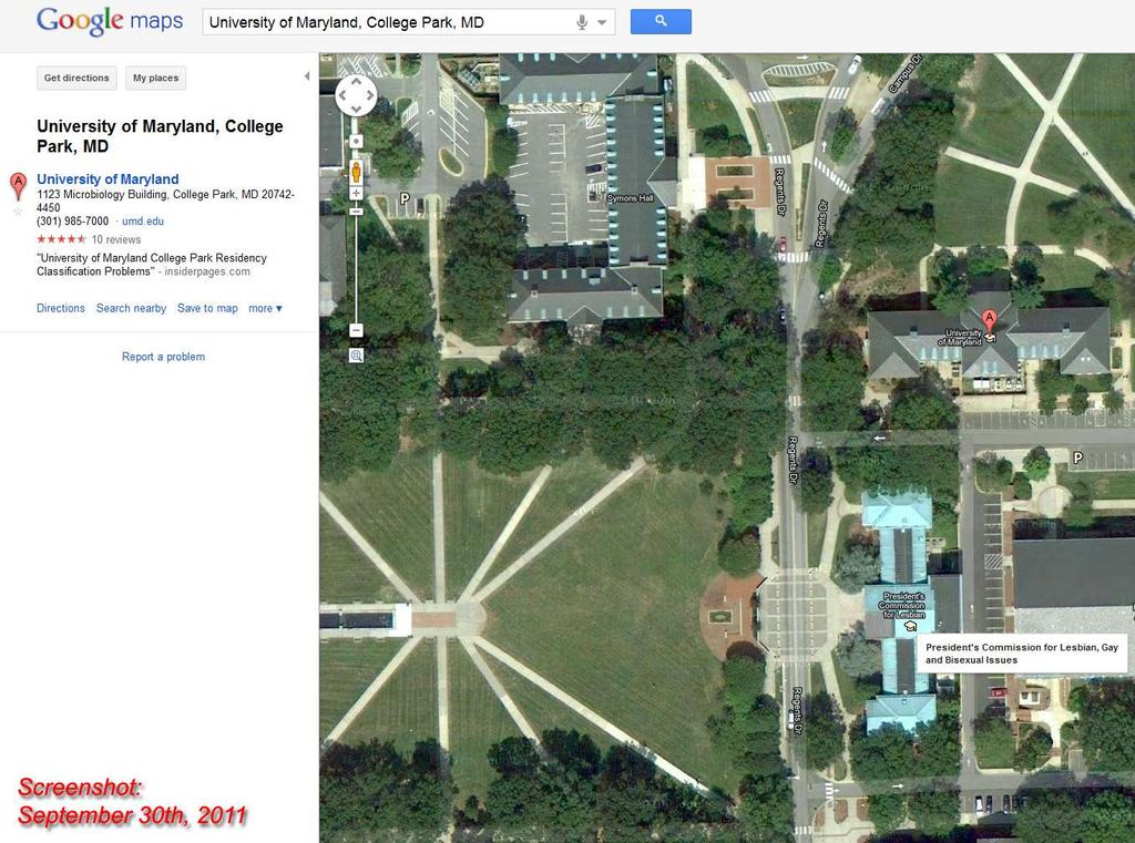
7 What does an Enterprise GIS do that Google Maps can t? Security handled by the Central Authentication Service (CAS) permits controlled editing and limiting access to sensitive information We control the data representing UMD, including level of detail mapped and information content No data size constraints Timely updates based on UMD s needs Easily integrated with other University information systems Can integrate Google / Bing / Esri and MD imap data layers
8 Assurance of accuracy, internally regulated update cycles, and direct control over how the university is represented to the public Otherwise, with externally produced unmanaged mapping (e.g. Google Maps, Bing Maps) there is a significant risk of being misrepresented or even causing harm through inaction
9
10
11 UMD Site License $45,000 annually for premium Access, Training, and Support Using resources already paid for! Expanding and enhancing programs already in place! Leveraging new time-saving templates!
12 ArcGIS Online Groups / Organizational Site Easy map creation and sharing Comments, Ratings Group management Privacy controls Public Maps Gallery Template ArcGIS for Facilities Management Campus Basemap Template (LGIM / Web Basemap) Campus Editing Template (LGIM / Desktop Tools) Campus Viewer Template (Web Application)

13 Make decisions based on authoritative information Improved partnerships and collaboration between academic and administrative units Ability to integrate systems and data from across the organization Institutionalized processes and expertise

14


15 Department GIS Department GIS Department GIS Information from Many Sources Standing up a central enterprise GIS is more cost effective than standing up multiple GIS servers / RDBMSs at the department level in terms of licensing costs, hardware, and technical support staff. Communication Breaking Down Barriers Enterprise GIS

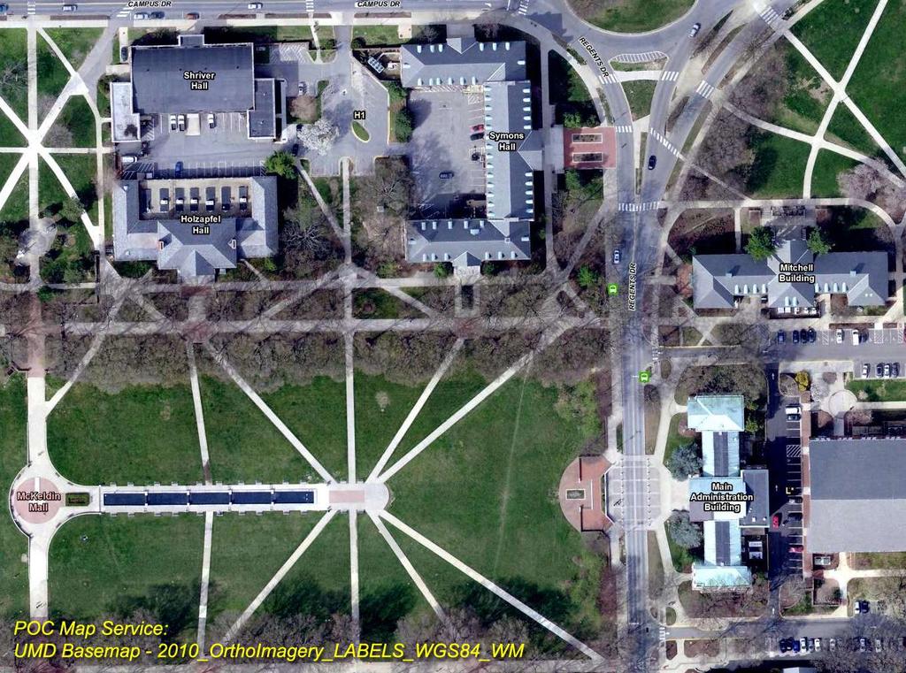
16 Features by Facilities Management Include: Buildings floor plans, footprints, room and space inventories Hardscape roadways, sidewalks, pavers, parking lots, athletic fields, structures Environmental wetlands, water bodies, forested stands, trees and landscaped vegetation Utilities infrastructure lighting, cameras, emergency phones, fire hydrants, underground delivery networks Topographic 1-foot elevation contours and surveyed elevation points including buildings

17 Department of Public Safety NextBus Shuttle UM Tracking System Field-Based Parking Lot Inventory and FM-DoTS hybrid parking lot and parking type GIS datasets Police Dispatch and Event Tracking System PERT Phones Other Departments: Campus Bike Rack Survey Sustainability
18 Exposing foundational campus basemap information to the campus community Maintaining a centralized web-accessible system that allows real time data access and collaboration through the shared mapping platform and linked information systems


19 Maps are outdated as soon as they are printed. Few campus maps are publically available and are they not easily adaptable to users needs. The campus population is a tech-enabled population with mobile computing at their fingertips. They expect a solution that matches their lifestyle. An interactive digital map will enhance the campus s image and engages students, staff, and visitors
20 Printed Maps are static and outmoded Students and visitors expect greater access to campus information Use of Mobile Devices and Tablets is on the rise We are a population no longer tied to our offices or desks for information Mobile access offers solutions that you can take with you and provides 10 instant answers to your question or needs 0 Desktop Users Laptop Users Mobile Users
")
21 Manage asset information Facilitate better planning and analysis Get information into and out of the field Provide comprehensive view of operations Engage constituents and customers Geo-enable other systems (e.g. calendars, class schedules)

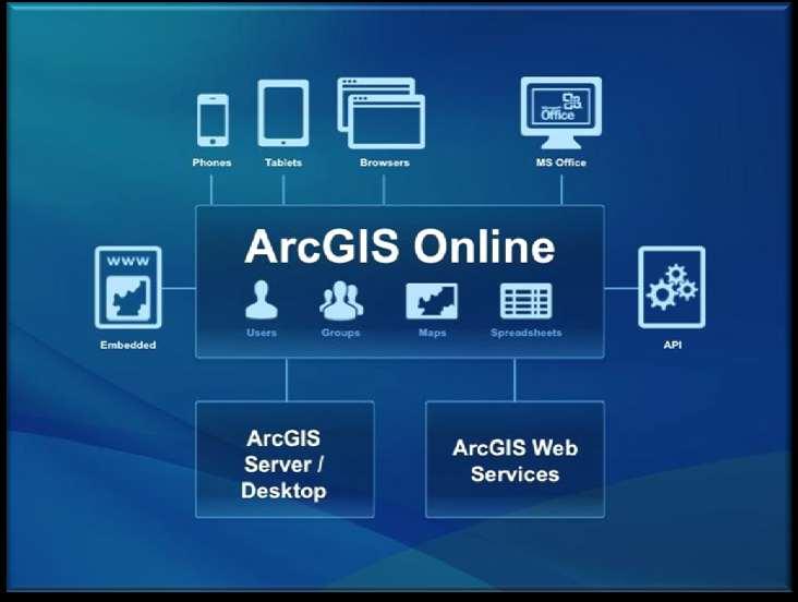
22


23 Visitors Students Emergency Services Faculty / Staff Enhanced Campus Experience Campus Walking Directions Highlight Points of Interest Real Time Campus Data Custom Map For Your Schedule Find Events On Campus What's going on near you? Room to Room Navigation Use your Mobile Device To Flag An Issue On The Spot Accurate Building Information Current Campus Conditions View Event Locations To Plan Staffing View Details from Campus Wide To Room Specific Time and Cost Savings Work Order Integration Improved Asset Management Better Informed Planning Decisions Find / Book Conference Rooms Accessible and Actionable Campus Data


24 Use The Microsoft Office Suite


25 UMD Directory ID & Password Through the use of CAS, a user can only see the information that they have access too. Department User Group Personal Level A department/group can create a map with a range of available data 1. Public: Layers from Google, Esri, governmental agencies, MD imap and other sources 2. Semi-public: Data created by UMD departments designated for university community use 3. Private: Data not shared between departments or beyond user groups Layers can be added / removed and the display of the information can be modified 1. Locational or attribute queries to limit results 2. Color of features or degree of visibility 3. Labeling or symbol used to identify feature


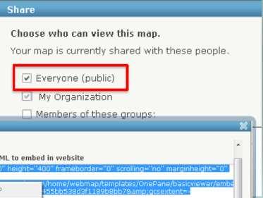
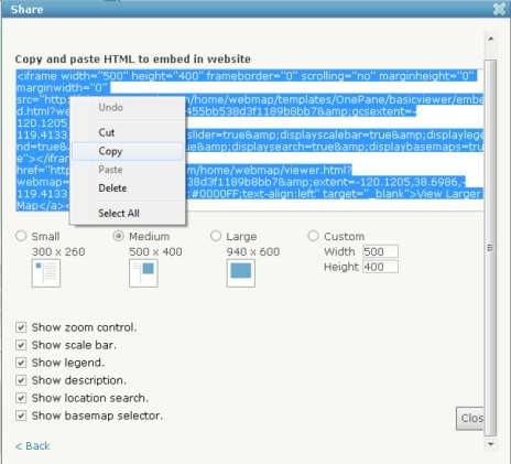
26 Water Valve ID: Depth 15.3 Sewer Manhole Depth: 12 1in / 1out Sewer Line Length: 7.2 Diameter: 6 Slope: 3.2% Water Line Length: 7.2 Diameter: 6

")


27 Targeted Messaging Volunteered Geographic Information (VGI) Twitter/Ushahidi 311 Community Awareness Situation Awareness SMS Twitter Browser Analysis... Provide actionable information & integrate feedback


28 Making Mapping more Accessible and Actionable Campus Webmap Development
29 Enhanced campus basemap High-level cartography Identification and quantification of campus features and landscape types Facilitates easy creation field-based asset surveying and framing of features in a broader spatial context Expanded and enriched datasets through collaboration with other departments

30
31 LIVE DEMONSTRATION

32 A cloud platform where anyone can make, share and host maps and apps
33


34 Logo and name Custom URL Featured maps Gallery Basemaps and default Web app templates


35 Customize Default Basemaps Application Templates


36 Copy and Paste HTML -No programming Easily Control Access
37 LIVE DEMONSTRATION

38 1. Get support and buy-in from Campus Administration 2. Create Campus GIS Steering Committee: Identify key issues for further development with an understanding that GIS will be the driving force and integration point for other information systems 3. Develop Proof-of-Concept Interactive Campus Map into a ready to use Public Campus Map We are here! 4. Publish Public Campus Map (map.umd.edu) 5. Provide access to and invite additional campus groups to participate in established system
39 Through the Campus GIS Steering Committee Task Forces: Identify and involve key campus stakeholders and system facilitators Design and implement system infrastructure Identify and prioritize key mapping applications and data requirements Maintain development, staging, and production environments Streamline interdepartmental communication and data sharing (database centralization and consolidation) Test for performance, scalability, and security
40 A collaborative effort to create a centralized campus management system Ability to link all campus databases (with full security control) Integrated collection and archiving schema Improved accessibility and scheduled backups Built using internal resources and expertise Staff, Faculty, and Students


41
42 More timely access to more accurate information More and higher quality communication Better decision making tools Increased operational awareness Enhancements to existing management and information dissemination systems
43 QUESTIONS TAYLOR KEEN Campus GIS Coordinator University of Maryland Facilities Management
ArcGIS for Land Records
 Virginia Association of Assessing Officers 63 rd Annual Conference October, 2011 ArcGIS for Land Records Arthur Robinson, Solution Engineer Bob Rike, Account Executive ArcGIS is a System A Complete System
ArcGIS for Water Utilities
 ArcGIS for Water Utilities Mark Robbins Joe Morocco Agenda Introductions ArcGIS for Water Utilities Overview Demonstrations Getting Started with ArcGIS for Water Utilities Common Deployment Scenarios Discussion
Deploying Mobile Solutions Agenda. Quick Overview on Strategy Walk thru of Mobile Apps Deploying Mobile Apps
 Deploying Mobile Solutions Agenda Quick Overview on Strategy Walk thru of Mobile Apps Deploying Mobile Apps ArcGIS Apps Making mapping and location aware apps available across your organization Knowledge
Performing Cost Effective Asset Management Inventories Utilizing GIS. Steve Tyler, Public Works Superintendent Mark Dumford, Consultant
 Performing Cost Effective Asset Management Inventories Utilizing GIS Steve Tyler, Public Works Superintendent Mark Dumford, Consultant Town of Atherton South San Mateo County 5 square miles Approximately
NASCIO 2013 Open Government Initiatives
 NASCIO 2013 Open Government Initiatives 1. Title: Utah s Open Transportation Data in the Cloud with ugate and UPlan 2. Category: Open Government Initiatives 3. Project Initiation and completion date The
ArcGIS Data Reviewer: An Introduction. Chandan Banerjee Jay Cary
 ArcGIS Data Reviewer: An Introduction Chandan Banerjee Jay Cary Workshop agenda Defining data quality What is ArcGIS Data Reviewer? Automated review Semi-automated review Managing errors Summary/resources
Esri Managed Cloud Services: An Introduction. Alec Walker
 Esri Managed Cloud Services: An Introduction Alec Walker Key Takeaways How to Identify Organizational Strategy & Priorities Esri s Cloud Offerings There s more than ArcGIS Online A Few Words on Esri Managed
How Web GIS supports a water utility
 How Web GIS supports a water utility An Esri White Paper JANUARY 2018 Esri Australia Pty Ltd, Level 3 111 Elizabeth Street Brisbane Qld 4000 P 1300 635 196 E connect@esriaustralia.com.au esriaustralia.com.au
Land Records Management at ArcGIS 10. Arthur Robinson Esri-Charlotte
 Land Records Management at ArcGIS 10 Arthur Robinson Esri-Charlotte ArcGIS A Complete System for Geographic Information Easier More Powerful Everywhere Mobile Web Discover Create Manage Visualize Analyze
An Esri White Paper October 2010 Esri Production Mapping: Meeting the Needs of Water and Wastewater Utilities
 An Esri White Paper October 2010 Esri Production Mapping: Meeting the Needs of Water and Wastewater Utilities Esri, 380 New York St., Redlands, CA 92373-8100 USA TEL 909-793-2853 FAX 909-793-5953 E-MAIL
Configuring the ArcGIS for Local Government Solution CHRIS FOX SCOTT OPPMANN
 Configuring the ArcGIS for Local Government Solution CHRIS FOX SCOTT OPPMANN Agenda Introduction Implementation Patterns Configuration Approaches Your Feedback ArcGIS as a Platform Simple, Open, and Configurable
Advanced Enterprise Work and Asset Management for Performance-Driven Utilities
 Advanced Enterprise Work and Asset Management for Performance-Driven Utilities Asset & Resource Management (ARM) 2 CGI s Asset & Resource Management (ARM) 2 suite is a solution designed to streamline the
ArcGIS for Local Government Solutions: An Overview. Rachel Weeden, Esri Patrick Callahan, Prince George s County
 ArcGIS for Local Government Solutions: An Overview Rachel Weeden, Esri Patrick Callahan, Prince George s County ArcGIS is a Platform Knowledge Workers Executive Access Public Engagement Work Anywhere Enterprise
MOBILE & WEB GIS. Improving Data Collection & Sharing
 MOBILE & WEB GIS Improving Data Collection & Sharing Suzanne M. Zitzman, GISP Maser Consulting P.A. Principal/Discipline Leader of GIS Asset Management Services Over 32 years experience in asset and facility
EXECUTIVE SUMMARY / BRIEF OVERVIEW
 EXECUTIVE SUMMARY / BRIEF OVERVIEW Roanoke County s Public Safety departments desired an application to replace a paper map-focused incident command system to one which could be easily deployed from any
Mid-West ESRI Utility User Group Meeting. March 27, 2008 Shakopee Fire Station Shakopee, MN
 Mid-West ESRI Utility User Group Meeting March 27, 2008 Shakopee Fire Station Shakopee, MN Introductions Thank You! Why go mobile? Utility Industry Challenges Reliability Customer Satisfaction Provide
ArcGIS for Water Utilities: An Introduction
 Esri International User Conference San Diego, California Technical Workshops July 26, 2012 ArcGIS for Water Utilities: An Introduction Howard Crothers Mike Miller Agenda Introduction ArcGIS for Water Utilities
Intergraph Mobile GeoSpatial Products. Bradley Skelton
 Intergraph Mobile GeoSpatial Products Bradley Skelton The Mobile Revolution Everyone has a mobile or tablet device People always have their mobile device with them Mobile market growing exponentially People
GIS Deployment at DeepWater Horizon. Lessons Learned 2010
 GIS Deployment at DeepWater Horizon Lessons Learned 2010 Primary Workflows Supported by GIS Connecting Individuals, Organizations and Communities Modeling and Analysis Planning Operations Field Data Collection/Damage
ArcGIS for Local Government Public Works Solutions. Scott Oppmann
 ArcGIS for Local Government Public Works Solutions Scott Oppmann GIS Is Evolving Your GIS Is Becoming Part of an Interconnected Platform Apps Web GIS Desktop Community Content Server Bringing Together
Best Practices for your ArcGIS Online Organization
 Best Practices for your ArcGIS Online Organization Bern Szukalski @bernszukalski Jeff Archer @vee_dubb Esri UC 2014 Technical Workshop Best Practices for your ArcGIS Organization Workshop Overview Not
Configuring for Agility: A Strategy for Sustainable Apps. Christian Carlson Scott Oppmann
 Configuring for Agility: A Strategy for Sustainable Apps Christian Carlson Scott Oppmann Why do you care? Generate greater return from your platform investments Mitigate service delivery issues Transition
Collector for ArcGIS: An Overview
 Federal GIS Conference February 9 10, 2015 Washington, DC Collector for ArcGIS: An Overview Carrie Tropasso GIS Technical Lead, PA DCNR Mike Bialousz GIS Director, PA DCNR Matt Kennedy Solutions Engineer,
SIGNATURE OF COUNTY ADMINISTRATOR OR CHIEF ADMINISTRATIVE OFFICER
 APPLICATION FORM All applications must include the following information. Separate applications must be submitted for each eligible program. Deadline: June 1, 2016. Please include this application form
ESRI ROADMAP FOR UTILITIES AND TELECOMMUNICATIONS COMPANIES
 ESRI ROADMAP FOR UTILITIES AND TELECOMMUNICATIONS COMPANIES Introduction Over the last several years, the ArcGIS has emerged as a true IT platform. According to Phil Simon, the author of the acclaimed
Best Practices for Utility Management. Presented by Steve Osiecki, GISP
 Best Practices for Utility Management Presented by Steve Osiecki, GISP Agenda Data management for utilities Developing harmonized CAD/GIS environment Importance of a good database structure Tools for implementation
The Power of Spatially Enabling Your Real-time Facilities Data. Copyright 2015 OSIsoft, LLC
 The Power of Spatially Enabling Your Real-time Facilities Data Presented by James Sullivan Recommended Flow of Topics in Agenda Business Challenge About GIS ArcGIS Platform and the PI System Create and
ArcGIS for Transportation. Tom Brenneman, Gary Waters
 ArcGIS for Transportation Tom Brenneman, Gary Waters ArcGIS for Transportation A product for Esri s transportation customers A series of useful maps and apps focused on transportation Organized into modules
UC-One. Keeping you connected to everyone and everything. Ebook Cisco public Cisco and/or its affiliates. All rights reserved.
 UC-One Keeping you connected to everyone and everything We spend over two-thirds of our workday communicating with people. Why not do it right? 75% Virtual teams are distracted during meetings How much
What is new with the ArcFM Solution
 What is new with the ArcFM Solution Telvent Utilities Has Become 2 ArcFM 10.2 Release Plan What is included in 10.2 Core ArcFM Feeder Manager 2.0 (FM 2.0), including support for large datasets All new
ArcGIS. for Land Records
 ArcGIS for Land Records Purpose Built and Configurable Gone are the days of building a custom real-time land records operation from scratch. Such systems are costly to maintain, lack capability, and don
Taking Advantage of ArcGIS Online to Push a Mobile Agenda
 2013 Esri International User Conference July 8 12, 2013 San Diego, California Taking Advantage of ArcGIS Online to Push a Mobile Agenda Michael Olkin Town of Amherst, MA Esri UC2013. Some of our goals
GIS Lighting Up The Enterprise
 Marketing Operations Field Workers IT Professionals Executives Project Management Citizen Engagement Mobile GIS Lighting Up The Enterprise Conference Theme - GIS Lighting Up the Enterprise Lighting up
REQUEST FOR PROPOSALS
 Announcement REQUEST FOR PROPOSALS ESRI GIS Implementation Services The Madison Metropolitan Sewerage District (MMSD or district ) seeks proposals from qualified vendors to implement Esri s geographic
LOCATION PLATFORM for Utilities
 LOCATION PLATFORM for Utilities How Mapping and GIS are Transforming Utilities Clifford Okembo We are a professional Geospatial solutions company who inspires, educates and enables our customers with working
ArcGIS for Emergency Management-
 ArcGIS for Emergency Management- Configuring the Solutions Jess Neuner Nikki Golding Agenda Introduction Solution Offering What s Next Your Feedback ArcGIS as a Platform Simple, Open, and Configurable
Implementing ArcGIS Solutions. Michael Beavers
 Implementing ArcGIS Solutions Michael Beavers mbeavers@esri.com ArcGIS as a Platform Simple, Open, and Configurable Knowledge Workers Executive Access Public Engagement Work Anywhere Enterprise Integration
Implementation of Portal for ArcGIS:
 Implementation of Portal for ArcGIS: A Provincial Ministry Perspective October 14 th, 2015 Zita Lo & Mitchell Knight Ontario Ministry of the Environment and Climate Change (MOECC) Geomatics Centre Outline
Working with ArcGIS for Canadian Municipalities
 Working with ArcGIS for Canadian Municipalities Today s Agenda This seminar is designed to help you understand: 1. The ArcGIS for Canadian Municipalities products and benefits 2. Implementing and configuring
ArcGIS for Emergency Management. Nikki Golding
 ArcGIS for Emergency Management Nikki Golding Agenda Introduction Solution Offering What s Next Your Feedback ArcGIS as a Platform Simple, Open, and Configurable Knowledge Workers Executive Access Public
Digital Transformation and Operational Intelligence in Utilities. Agendra Kumar President, Esri India
 Digital Transformation and Operational Intelligence in Utilities Agendra Kumar President, Esri India Agenda Market Observations and Trends Role of GIS Vision and Road Map for Smart Utilities Summary and
12th UNGIWG Plenary Meeting ArcGIS for UNGIWG and UNSDI
 12th UNGIWG Plenary Meeting ArcGIS for UNGIWG and UNSDI ssawaya@esri.com / @salim_sawaya Many people want your authoritative knowledge Co-workers Executives & decision makers Customers Citizens Co-workers
Emerging Trends For Local Government
 Emerging Trends For Local Government Sacramento GIS Users Group Dan Henderson, PMP, GISP Regional Team Lead, Local Government Sector Land Records Public Works Planning Economic Development Environment
Public Works Maps and Apps for Local Governments CHRIS FOX SCOTT OPPMANN
 Public Works Maps and Apps for Local Governments CHRIS FOX SCOTT OPPMANN Agenda Introduction Solution Offering What s Next Your Feedback ArcGIS as a Platform Simple, Open, and Configurable Knowledge Workers
ArcGIS Data Reviewer: An Introduction. Chandan Banerjee Jay Cary
 Chandan Banerjee Jay Cary Workshop Agenda Importance of Data Quality What is ArcGIS Data Reviewer? Automated review Semi-automated review Managing errors and reporting data quality Summary/Resources Importance
HOW LOCATION INTELLIGENCE DRIVES ELECTIONS. A Geographic Approach to Improving Voter Outreach and Constituent Engagement
 HOW LOCATION INTELLIGENCE DRIVES ELECTIONS A Geographic Approach to Improving Voter Outreach and Constituent Engagement GIS AND ELECTIONS CONTENT INTRODUCTION THE INTELLIGENT MAP BUILT IN LOCATION INTELLIGENCE
Enterprise Social Networks: Head-to-Head. MangoApps Exclusive Features
 Enterprise Social Networks: Head-to-Head MangoApps, Yammer, Chatter, Jive, and Box If you're looking to combine your independent communication and business tools so they work together smoothly and interoperate
e-school App Cloud and Mobile App based School Management System
 e-school App Cloud and Mobile App based School Management System Product & Solutions Institute, School Management System Online Admission Management System Cloud based Online Exam Management System e-school,
Implementing ArcGIS Solutions NIKKI GOLDING SCOTT OPPMANN
 Implementing ArcGIS Solutions NIKKI GOLDING SCOTT OPPMANN Agenda (Update) Introduction Implementation Patterns Opioid Epidemic Solution Configuration Approaches Your Feedback ArcGIS as a Platform Simple,
The Ultimate Guide to Rapid App Development. How to create business apps with no code and minimal resource investment
 The Ultimate Guide to Rapid App Development How to create business apps with no code and minimal resource investment 2 Digital transformation is disrupting classic workplaces and business processes Creative
Implementing ArcGIS Solutions. Matt Viverito Scott Oppmann
 Implementing ArcGIS Solutions Matt Viverito Scott Oppmann GIS Has Evolved Your GIS is an Interconnected Platform Apps Web GIS Desktop ArcGIS Server Bringing Together Data, Technology, and People......
The City of Yreka. Request for Proposal Asset Management System and Operations Management System th Street Yreka, California
 The City of Yreka Asset Management System and Operations Management System 701 4 th Street Yreka, California November, 2018 Table of Contents Yreka - Our City, Our Community... 3 Project Overview... 3
Getting started with open data and ArcGIS Hub. Graham Hudgins, esri product engineer
 Getting started with open data and ArcGIS Hub Graham Hudgins, esri product engineer Agenda Overview of open data in the ArcGIS Hub Demonstration of open data capabilities Preparing your data - best practices
ArcGIS Online for Administrators. Rachel Weeden
 ArcGIS Online for Administrators Rachel Weeden Agenda 1. Establishing the vision and governance 2. Configuring your organization s home 3. Establish your brand 4. Organize your organization 5. Add useful
ArcGIS Workflow Manager An Introduction
 Esri International User Conference San Diego, California Technical Workshops July 24, 2012 ArcGIS Workflow Manager An Introduction Kevin Bedel Nishi Mishra Session Topics Introduction to ArcGIS Workflow
Geospatial Mobility for Tablets and Smartphones. Dave Holmes, Intergraph
 Geospatial Mobility for Tablets and Smartphones Dave Holmes, Intergraph Mobile Solutions for Transportation Citizen Problem Reporting Smart Phone App Field Inspection Apple/Android Smart Tablet/Smart Phone
GIS Technology After Redistricting. Richard Leadbeater, Esri Global Manager August 8, 2012
 GIS Technology After Redistricting Richard Leadbeater, Esri Global Manager August 8, 2012 Redistricting Online Increasing the collaboration between government and citizens Review Connect Public Web Mashups
Geo-enable the enterprise - The power of location - There is a wealth of decision-support information hidden in your data that you cannot ever see
 1 2 3 Geo-enable the enterprise - The power of location - There is a wealth of decision-support information hidden in your data that you cannot ever see when you look at it in systems like Excel, SharePoint,
Smart Installations. Ben Conklin Jim Bauer
 Smart Installations Ben Conklin Jim Bauer Smart Installations Responding to challenges and leveraging advances in technology A Smart Installation improves operational readiness by providing shared understanding
Leveraging GIS to Improve Operations and Asset Management Lifecycle
 Leveraging GIS to Improve Operations and Asset Management Lifecycle Gabriel Borroni Joel Gladfelter ESRI AEC Summit 2014 San Diego, CA Asset Management Inventory Control Maintenance Management Scheduling/
City of Elk Grove Evolving the use of GIS
 City of Elk Grove Evolving the use of GIS Interwest GIS Steve Gay, GISP Jason Latoski www.interwestgrp.com/gisblog Interwest Consulting Group Provides GIS and IT Services to local governments Contracted
AUGUST 11, 2015 Page 1 of b - CC
 AUGUST 11, 2015 Page 1 of 38 8. b - CC County Council Meeting Date: August 11, 2015 Submitted by: Subject: Morgan Calvert, Manager of Information Technology and Durk Vanderwerff, Manager of Planning Enterprise
On-Demand Solution Planning Guide
 On-Demand Solution Planning Guide Powering On-Demand Solutions www.growthclick.com hello@growthclick.com Copyright 2019 GrowthClick Inc. All Rights Reserved. 1 3 Steps to Planning an On-Demand Solution
ArcGIS Data Reviewer: An Introduction. Chandan Banerjee Jay Cary
 ArcGIS Data Reviewer: An Introduction Chandan Banerjee Jay Cary Workshop agenda Importance of data quality What is ArcGIS Data Reviewer? Automated review Semi-automated review Managing errors and data
Establishing Data Fusion Center Baseline Technology Capabilities. Paul Christin ESRI David Stampfli Microsoft
 Establishing Data Fusion Center Baseline Technology Capabilities Paul Christin ESRI David Stampfli Microsoft Problem The asymmetrical threat of organized crime, gangs, drug cartels and terrorist organizations
RFI Content Management System Tools Questions & Answers
 RFI 180030 Content Management Tools Questions & Answers Question Answer 1 We are concerned that we will not have enough resources at this point in the year to present a demonstration on the 18th of December.
Esri Defense Mapping for Server: Defense Product On Demand. Jeremiah Moore G.C. Rice
 Esri Defense Mapping for Server: Defense Product On Demand Jeremiah Moore G.C. Rice Overview Esri Defense Mapping Esri Defense Mapping Produce, Manage, and Share Authoritative Content System of Engagement
What s New in ArcGIS Enterprise Bill Major Craig Cleveland
 What s New in ArcGIS Enterprise Bill Major Craig Cleveland Agenda Overview of ArcGIS Enterprise New in administration New in publishing New in analysis Overview ArcGIS Enterprise is a full-featured mapping,
ArcGIS for State and Local Government: An Overview. Nikki Golding Scott Oppmann
 ArcGIS for State and Local Government: An Overview Nikki Golding Scott Oppmann Agenda Introduction Why are we doing this? What are we doing to help? ArcGIS as a Platform Knowledge Workers Executive Access
ArcGIS for Emergency Management: An Overview
 2013 Esri International User Conference July 8 12, 2013 San Diego, California Technical Workshop ArcGIS for Emergency Management: An Overview Jeff Baranyi Lindsay Thomas Esri UC2013. Technical Workshop.
Leveraging Geography to drive Business Value
 Leveraging Geography to drive Business Value MidWest ESRI Utility User Group Ken Brelsford ESRI ESRI would like to thank you for taking the time to support the MidWest ESRI Utility User Group. The following
Proven steps to get the most out of your GIS investment. Paul Burgess Anna Sokol
 Proven steps to get the most out of your GIS investment Paul Burgess Anna Sokol The Esri Method Maximize Business Impact with GIS Definition and Purpose High level approach any organization can follow
The Importance of Data Quality Within Your Organization. Sherry Fagin and Andy Ommen
 The Importance of Data Quality Within Your Organization Sherry Fagin and Andy Ommen Workshop Agenda Perspectives of Data Quality What is ArcGIS Data Reviewer? Quality Control Processes Reporting Data Quality
Recommendation: Directory Services Architecture and Future IAM Governance Model
 Recommendation: Directory Services Architecture and Future IAM Governance Model I. EXECUTIVE SUMMARY Identity and access management (IAM) is a broad administrative function that identifies individuals
Inject GIS into your Business Systems. Gerry Clancy Marten Hogeweg
 Inject GIS into your Business Systems Gerry Clancy Marten Hogeweg GIS Is Integrating Geography into Everything We Do Changing the Way We Think and Act Bringing Together Data, Technology, and People......
A Better Way to Manage Assets and Infrastructure. Mutasem Jokhdar InfoGraph
 A Better Way to Manage Assets and Infrastructure Mutasem Jokhdar InfoGraph TITLE SLIDE InfoGraph (Founded in 1991) InfoGraph Specialty is Geographic Information Systems (GIS) & Remote Sensing software
ArcGIS Extensions: Tools for Improving Data and Map Production. Amber Bethell & Sean Granata
 ArcGIS Extensions: Tools for Improving Data and Map Production Amber Bethell & Sean Granata No Standards With Standards Data and Map Production Productivity Cartography Efficiency Automation Accuracy Standardization
Cliffs Notes Operations Management System (OMS)
") Cliffs Notes Operations Management System (OMS) We re Cartegraph. We design and build simple, innovative operations management technology that helps organizations save time and money and we ve been doing
Cliffs Notes Operations Management System (OMS) We re Cartegraph. We design and build simple, innovative operations management technology that helps organizations save time and money and we ve been doing
TOP 20 QUESTIONS TO ASK BEFORE SELECTING AN ENTERPRISE IAM VENDOR
 TOP 20 QUESTIONS TO ASK BEFORE SELECTING AN ENTERPRISE IAM VENDOR The need for a robust and flexible enterprise-grade identity and access management (IAM) solution has never been greater. IAM is increasingly
HANOVER COUNTY PUBLIC SAFETY GEOGRAPHIC INFORMATION SYSTEM WEB APPLICATION JJune 2011
 HANOVER COUNTY PUBLIC SAFETY GEOGRAPHIC INFORMATION SYSTEM WEB APPLICATION JJune 2011 PUBLIC SAFETY GEOGRAPHIC INFORMATION SYSTEM WEB APPLICATION Category: Criminal Justice & Public Safety Project Summary
ArcGIS for Emergency Management 1:00 2:15pm
 Esri Southwest User Conference September 17-19, 2012 Denver, Colorado ArcGIS for Emergency Management 1:00 2:15pm Jeff Baranyi jbaranyi@esri.com @GISPublicSafety 303-449-7779 Agenda Overview of ArcGIS
Coming Soon! To a PI System Near You
 Coming Soon! To a PI System Near You Presented by John Baier Director, Marketing Agenda and Expectations This presentation assumes: You know the PI System basics You understand the modern PI System AF,
MiCloud Flex. Services Overview. Advanced, Customizable Business Communications Solution in the Cloud. Enterprise Quality Meets Flexibility.
 MiCloud Flex Services Overview Advanced, Customizable Business Communications Solution in the Cloud Enterprise Quality Meets Flexibility. When you think about business communications, it s much more than
A Modern Vision of Enterprise GIS. Adam Carnow and Keith Cooke
 A Modern Vision of Enterprise GIS Adam Carnow and Keith Cooke If all you ever do with GIS is make paper maps, then that is the only thing your customers will ask you for Successful GIS Implementation
Xander Mavrides, PhD, GISP
 Xander Mavrides, PhD, GISP Common Operating APPLYING NEW TECHNOLOGY TO MAINTAIN THE VIABILITY OF A MAJOR INVESTMENT. THE AMERICAN SOCIETY OF MECHANICAL ENGINEERS - 1995 Citywide GIS Resource Spatial Data
ArcGIS for State and Local Government
 Federal GIS Conference 2014 February 10 11, 2014 Washington DC ArcGIS for State and Local Government Nikki Golding ArcGIS A Platform for Geographic Information Desktop Web Device ArcGIS Solutions Local
POWER PORTFOLIO PRODUCT BROCHURE
 POWER PORTFOLIO PRODUCT BROCHURE 2 Power Portfolio Change is constant and its impacts can affect you personally. Whether man-made or naturally occurring, our changing landscape influences your plans and
PRODUCT BROCHURE POWER PORTFOLIO
 PRODUCT BROCHURE POWER PORTFOLIO 2 Power Portfolio Change is constant and its impacts can affect you personally. Whether man-made or naturally occurring, our changing landscape influences your plans and
Boost Mining Profits with Esri
 Boost Mining Profits with Esri Seize the Power of the Platform When you deploy ArcGIS software from Esri, you harness the power of location. Now you can wield that power to manage, plan, analyze, map,
Distributing Power BI Content
 Distributing Power BI Content Distributing Power BI Content Heidi Enho Microsoft MVP (Data Platform & Excel) Microsoft Certified Trainer, MCSA heidi.enho@sulava.com HExcelligent.fi, vilahdus.fi Objectives
ArcGIS 9.3 Business Analyst Server The GIS and Data Solution for Enterprise Business Analysis ESRI Developer Summit 2008
 ArcGIS 9.3 Business Analyst Server The GIS and Data Solution for Enterprise Business Analysis ArcGIS 9.3 Business Analyst Server The Team Bob Hazelton Product Manager Garry Burgess Product Architect Igor
ICONICS UK Ltd. All rights reserved Page 1
 ICONICS UK Ltd. All rights reserved Page 1 1Script-less HTML5 Thin Client Technology Reduce the time it takes to recognise and fix issues by accessing your real-time data on any mobile device, via a truly
Location-driven business at the
 Location-driven business at the Utah Department of Transportation Jeff Saunders Farallon Geographics, Inc. Senior Geodatabase Developer Dan Paske Utah Department of Transportation Oracle DBA Today s Goals
Public Health Maps and Apps for Local Governments SCOTT OPPMANN
 Public Health Maps and Apps for Local Governments SCOTT OPPMANN ArcGIS as a Platform Simple, Open, and Configurable Knowledge Workers Executive Access Public Engagement Work Anywhere Enterprise Integration
Managing Gas Facility Inspections with Workforce for ArcGIS. Esri GeoConX 2017
 Managing Gas Facility Inspections with Workforce for ArcGIS Esri GeoConX 2017 Peoples Gas Founded in 1850 Deliver natural gas to about 843,000 customers in the city of Chicago. ~20 GIS staff supporting
Thinking of using Microsoft Office 365 For Your Business? If Not, You Should.
 Thinking of using Microsoft For Your? If Not, You Should. www.intivix.com (415) 543-1033 info@intivix.com Why should my business use? Because Microsoft is built for businesses of all sizes, and its tools
Esri Roads and Highways An Introduction
 Esri International User Conference San Diego, California Technical Workshops July 24, 2012 Esri Roads and Highways An Introduction William Isley Majunu Seran Agenda Product Overview Desktop - Demo: Network