Application of remote sensing by the New Zealand forest industry. Aaron Gunn
|
|
|
- Melvyn Charles
- 5 years ago
- Views:
Transcription
1 Application of remote sensing by the New Zealand forest industry Aaron Gunn
2 Presentation Overview History LiDAR Cluster Group Personal Experience - Blakely Pacific Ltd (silvicultural scheduling) Remote Sensing achievements in NZ Plantation Forestry Digital Elevation Models LiDAR based Forest Inventory System - knn Individual tree identification Satellite Imagery - Rapid Eye

3 History LiDAR Cluster Group NZ LiDAR Cluster Group established 2011 Capture specifications Data storage Capture collaborations Processing Products required

4 History LiDAR Cluster Group Scion/FFR research Developed standards for LiDAR capture in a NZ forestry environment Provided insights to: Processing software options LiDAR terminology Provided assistance to forestry companies

5 Blakely Pacific LiDAR Project 9,000ha of Douglas-fir forest In-sufficient inventory information Sites established between 1995 & 2003 Thinning operations looming!

6 Tree Height Model


7 Program results to date Provided immediate identification of high productive sites 18% of project now completed Improved operational efficiencies & cost savings

8 Additional Benefits Contour dataset Digital Elevation Model


9 Remote Sensing Achievements - NZ Forestry Digital Elevation Models LiDAR based Forest Inventory System Individual tree identification HarvestNav Application Rapid Eye/SatTools - EVI


10 Digital Elevation Model (DEM) Especially valuable during the harvesting and road planning stage for steep-land sites. Is the base for above ground LiDAR point cloud sampling.
11 Optimal Point Density - DEM Minimum ground return density for a DEM = 0.2 ground returns per m² Spreadsheet developed to determine DEM capture specifications Determining minimum LiDAR pulse density for an accurate DEM, under forested conditions User defined inputs Outputs Crop age (years) 28 Predicted percent ground returns (%) Crop stocking (stems/ha) 500 Pulse density required (points/m2) 0.9 Noncrop stocking (stems/ha) 0 Stand slope (degrees) 20
 Initial LiDAR capture:")


12 Optimal Point Density - CHM (capture over Douglas-fir forest) Initial LiDAR capture: Minimum pulse density for acquisition is 2-3 pulses/m2 Subsequent LiDAR capture: Once an accurate DEM is available - key metrics of interest could be predicted from a capture specification of 0.2 pulses/m2!!

13 LiDAR and Forest Inventory - Background LiDAR does not measure recoverable volume or replace existing methods. We still need: Plots measured by trained professionals Yield modelling software Tree and plot biometric functions
14 LiDAR and Forest Inventory - Background Aerial LiDAR provides auxiliary information that can be useful for forest inventory Fewer plots = $ saving Productivity Surfaces = better resolution information Estimates for AOI: stands felling coupes


15 LiDAR and Forest Inventory - Background A LiDAR based inventory system must provide: Yield tables including log product estimates Sampling error for AOIs Use current software and models

16

17 knn Case Studies Tairua Eastern BOP Kaingaroa

18 Kaingaroa Case Study FFR funded project to investigate LiDAR inventory methods Kaingaroa 4000ha trial area 213 plots ground plots installed Yields and sampling error for 102 stands Independent validation dataset
19 Validation suggests excellent performance TRV MTH BA Sph

20 Key conclusions knn technique Provides a robust and practical solution for using LiDAR data for forest inventory. Is suitable to replace some components of current forest inventory practices. Can extrapolate a small number of ground plots to many stands using existing software & biometric functions Provides accurate results and precision benefits at the stand level
21 Individual Tree Identification

22 Individual Tree Identification

23 HarvestNav Is an application that runs on a tablet computer and displays and informs operators about the surrounding terrain
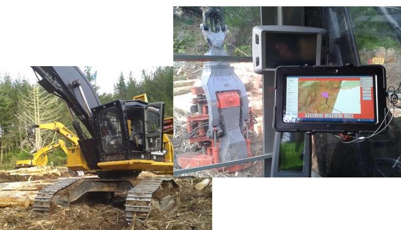
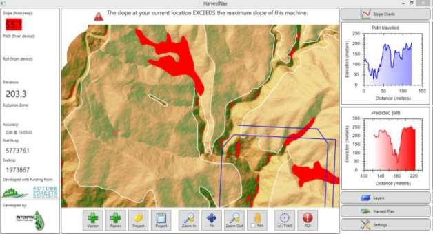
24 HarvestNav Field Trials
25 HarvestNav Operators comfortable with technology GPS (on the tablet) reception in cab seems excellent Appears to be an effective way of communicating harvest planning information to operators Future advancements planned

26 Table 1: Selected satellite sensors and their characteristics. 1 Prices are based on images available in the archive and are correct as at September Red, green and blue; NIR - near infrared : Pan - Panchromatic Satellite Imagery
 Detection of the Crop")
27 RapidEye & Enhanced Vegetation Index (EVI) Detection of the Crop using


28 RapidEye & Enhanced Vegetation Index (EVI) Detection of Harvest Area


29 Satellite Imagery for Disease Detection Spray plot locations coloured by mean needle drop % (no disease) (disease expressed)
30 Key Highlights LiDAR Cluster Group assisted with the early uptake of LiDAR technology and the format of having all interested parties at the table was very beneficial LiDAR & Blakely Pacific Now feel comfortable using this technology.
31 Key Highlights Remote Sensing Achievements - NZ Forestry Confidence in LiDAR capture specifications Proven method for LiDAR based inventory We can count trees using LiDAR We have a tablet based on-board navigation system that utilises LiDAR derived DEMs Satellite imagery option that allows the calculation of an EVI
USING LIDAR AND RAPIDEYE TO PROVIDE
 USING LIDAR AND RAPIDEYE TO PROVIDE ENHANCED AREA AND YIELD DESCRIPTIONS FOR NEW ZEALAND SMALL-SCALE PLANTATIONS Cong (Vega) Xu Dr. Bruce Manley Dr. Justin Morgenroth School of Forestry, University of
Improving Forest Inventory: Integrating Single Tree Sampling With Remote Sensing Technology
 Improving Forest Inventory: Integrating Single Tree Sampling With Remote Sensing Technology C.J. Goulding 1, M. Fritzsche 1, D.S. Culvenor 2 1 Scion, New Zealand Forest Research Institute Limited, Private
Using Imagery and LiDAR for cost effective mapping and analysis for timber and biomass inventories
 Using Imagery and LiDAR for cost effective mapping and analysis for timber and biomass inventories Mark Meade: CTO Photo Science Mark Milligan: President LandMark Systems May 2011 Presentation Outline
Scion overview. Michael Watt, Research Leader, Scion
 Scion from the air UAV July 2015 Michael Watt, Research Leader, Scion SCION: a New Zealand Crown Research Institute for Forestry, wood product and wood-derived materials Scion overview 1 Scion profile
ASSESSING THE STRUCTURE OF DEGRADED FOREST USING UAV
 ASSESSING THE STRUCTURE OF DEGRADED FOREST USING UAV STUDY CASE IN YUNGAS CLOUD FOREST, NORTH ARGENTINA Fernando Rossi 1, Andreas Fritz 2, Gero Becker 1, Barbara Koch 2 Albert-Ludwigs-Universität Freiburg
INVENTORY? - MEASUREMENTS & - BASIC STATISTICS ARE IMPORTANT FOR PRUDENT FOREST MANAGEMENT
 INVENTORY? - MEASUREMENTS & - BASIC STATISTICS ARE IMPORTANT FOR PRUDENT FOREST MANAGEMENT BY BALOZI AND JARNO Contents What is ArboLiDAR? Input data Sampling and field work Automatic stand segmentation
Predicting productivity using combinations of LiDAR, satellite imagery and environmental data
 Date: June Reference: GCFF TN - 007 Predicting productivity using combinations of LiDAR, satellite imagery and environmental data Author/s: Michael S. Watt, Jonathan P. Dash, Pete Watt, Santosh Bhandari
Technology transfer and uptake: Industry perspective. Elaine Birk, Rayonier New Zealand
 Technology transfer and uptake: Industry perspective Elaine Birk, Rayonier New Zealand Outline 1. Personal journey with Tech Transfer 2. What is Tech Transfer definitions 3. What factors limit successful
Enhanced Forest Inventory A case study in the Alberta foothills
 SISCO Southern Interior Silviculture Committee Enhanced Forest Inventory A case study in the Alberta foothills Roger Whitehead & Jim Stewart CFS, Canadian Wood Fibre Centre Glenn Buckmaster West Fraser
Big Databases in forest planning and operations New national lidar campaign in Sweden
 Big Databases in forest planning and operations New national lidar campaign in Sweden NB-Nord workshop Erik Willén Process Manager Digitalization Main research partners: LUKE (FI) Metsäteho (FI) Skogforsk
The Use of GIS in Site-Specific Forest Management
 The Use of GIS in Site-Specific Forest Management Christian Brodbeck Biosystems Engineering, Auburn University John Fulton, Joey Shaw, Tim McDonald, and Donn Rodekohr Auburn University Value Map The Goal
Enhanced Forest Inventory A case study in the Alberta foothills
 Enhanced Forest Inventory A case study in the Alberta foothills Roger Whitehead & Jim Stewart CFS, Canadian Wood Fibre Centre Glenn Buckmaster West Fraser Mills, Hinton Wood Products Mike Wulder, Joanne
$ / maximum area Imagery $10-20 No limit $<1-3. $ / minimum area
 Technical Note Forest Industry Applications of UAVs 20 July 2017 Authors: Dr Grant Pearse *, Dr Michael Watt. * Corresponding author: grant.pearse@scionresearch.com Summary A recent project at Scion explored
Subscribe Share Past Issues Transl
 Subscribe Share Past Issues Transl View this email in your browser Welcome to our September edition of the R&D Works newsletter. This month our stories include a bio-composite material made from pulp and
What s under the canopy Using airborne and terrestrial laser scanning to characterise forest structure
 What s under the canopy Using airborne and terrestrial laser scanning to characterise forest structure David Pont, Michael Watt, Heidi Dungey, Toby Stovold, Ben Morrow, Rod Brownlie, Marie Heaphy Tree-based
Forestry and Agricultural Greenhouse Gas Modeling Forum # Shepherdstown, WV
 Forestry and Agricultural Greenhouse Gas Modeling Forum #4 March 6-8, 6 2007 Shepherdstown, WV Overview of scientific, technical and methodological issues related to reducing emissions from deforestation
Mining for the Timber-Volume for a State-Wide Forest Information System. LIDAR Mapping Forum, February, 15th, 2017 Dr.-Ing.
 Mining for the Timber-Volume for a State-Wide Forest Information System LIDAR Mapping Forum, February, 15th, 2017 Dr.-Ing. Arno Buecken Sustainable Usage of the Forest Key Idea: Do not harvest more than
COSMO-SkyMed data for detection of forest boundaries on steep terrain
 Photo Credit: Peter Morley COSMO-SkyMed data for detection of forest boundaries on steep terrain Peter Morley 1, Sophie Davison 3, Alistair Jump 1, Daniel Donoghue 2 Why mountain forests? 23% earths forested
Goal of project Importance of work Software and processes Methods Results and discussion Strengths and limitations Conclusions 3/11/2010
 Presented by Joey Roberts and James Bradd Goal of project Importance of work Software and processes Methods Results and discussion Strengths and limitations Conclusions 1 Test hypothesis that the distribution
Remote Sensing (C) Team Name: Student Name(s):
 Team Name: Student Name(s):") Team Name: Student Name(s): Remote Sensing (C) Nebraska Science Olympiad Regional Competition Henry Doorly Zoo Saturday, February 27 th 2010 96 points total Please answer all questions with complete sentences
Team Name: Student Name(s): Remote Sensing (C) Nebraska Science Olympiad Regional Competition Henry Doorly Zoo Saturday, February 27 th 2010 96 points total Please answer all questions with complete sentences
Methodologies of tropical forest carbon monitoring: Development and state-of-the-art for REDD+
 Methodologies of tropical forest carbon monitoring: Development and state-of-the-art for REDD+ International Symposium on Southeast Asian Tropical Rain Forest Research related with Climate Change and Biodiversity,
Forest Assessments with LiDAR: from Research to Operational Programs
 Forest Assessments with LiDAR: from Research to Operational Programs David L. Evans Department of Forestry Forest and Wildlife Research Center Mississippi State University Forest Remote Sensing: Then and
Woodland owners routinely want to measure property acreage,
 Archival copy. For current version, see: https://catalog.extension.oregonstate.edu/ec119 Tools for Measuring Your Forest EC 119 Revised November 014 Steve Bowers, Tristan Huff Woodland owners routinely
Forest data services of the Finnish Forest Centre. Juho Heikkilä, Chief Forest Data Specialist, Lic.Sc. (For.) Lahti, Finland, May 31, 2017
 Lahti, Finland, May 31, 2017") Forest data services of the Finnish Forest Centre Juho Heikkilä, Chief Forest Data Specialist, Lic.Sc. (For.) Lahti, Finland, May 31, 2017 Finland - the most forested land in Europe The population of Finland
Forest data services of the Finnish Forest Centre Juho Heikkilä, Chief Forest Data Specialist, Lic.Sc. (For.) Lahti, Finland, May 31, 2017 Finland - the most forested land in Europe The population of Finland
2 nd generation Lidar techniques in complex forested terrain
 2 nd generation Lidar techniques in complex forested terrain Peter J M Clive Technical Development Consultant SgurrEnergy Ltd 225 Bath Street Glasgow G2 4GZ E: peter.clive@sgurrenergy.com T: +44.141.227.1724
Application of airborne LiDAR in forestry in North America and Scandinavia. ForestrySA LiDAR initiatives
 Application of airborne LiDAR in forestry in North America and Scandinavia ForestrySA LiDAR initiatives Jan Rombouts Airborne LiDAR is a great data source for forestry Transect through LiDAR data set,
BLUNT FIRE INCREMENTAL SILVICULTURE PROJECT
 BLUNT FIRE INCREMENTAL SILVICULTURE PROJECT Results of 8yr. Re-Sampling of Permanent Sample Plots Response of Subalpine Fir (Abies lasiocarpa) to Thinning and Fertilization in the ESSFmc Prepared for:
NEW USES FOR OLD DATA Green Triangle Permanent Growth Plot Projects
 NEW USES FOR OLD DATA Green Triangle Permanent Growth Plot Projects Dr Jim O Hehir General Manager Planning and Development And many others Green Triangle SE South Australia and SW Victoria South Australia
Executive Summary. FIA-FSP Project Number: Project Title: Project Purpose: Management Implications:
 Executive Summary FIA-FSP Project Number: Project Title: Project Purpose: Management Implications: Y081171 Equivalent clear cut area thresholds in large-scale disturbed forests The purpose of this project
L.W. Schatz Demonstration Tree Farm Annual Report
 2012 Annual Report 2012 Annual Report Inside this report: Cover Story 1 Research and other projects in 2012 Summer operations & maintenance in 2012 Summer operations & maintenance planned for 2013 Research
Simulating UAV sampling using high-density Lidar data to characterize the structure of short canopies
 Simulating UAV sampling using high-density Lidar data to characterize the structure of short canopies IAPP Project nr. 286079 Aircraft for Environmental and Forest Science AIRFORS Loris Vescovo, Chiara
The Digital Forest. Geospatial Technologies in Urban Forest Management. Justin Morgenroth New Zealand School of Forestry University of Canterbury
 The Digital Forest Geospatial Technologies in Urban Forest Management Justin Morgenroth New Zealand School of Forestry University of Canterbury Why Measure a Tree? Determine annual growth Determine value
Newfoundland Fibre Inventory Project Maximizing the value of forests through enhanced inventory of fibre attributes
 Newfoundland Fibre Inventory Project Maximizing the value of forests through enhanced inventory of fibre attributes Background CBPPL Atlantic Innovation Fund (AIF) Project maintain and increase the competitiveness
PGP Steepland Harvesting: a collaborative research and development programme
 PGP Steepland Harvesting: a collaborative research and development programme Keith Raymond Forest Growers Research Ltd NZ Institute of Forestry Conference 10 July 2018 Forest Growers Research aspirations
A Remote Sensing Based System for Monitoring Reclamation in Well and Mine Sites
 A Remote Sensing Based System for Monitoring Reclamation in Well and Mine Sites Nadia Rochdi (1), J. Zhang (1), K. Staenz (1), X. Yang (1), B. James (1), D. Rolfson (1), S. Patterson (2), and B. Purdy
Characterisation, modelling and assessment of native vegetation condition in Tasmania
 Characterisation, modelling and assessment of native vegetation condition in Tasmania Who: Grant Dickins & Karyl Michaels, Project 1, University of Tasmania & RMIT University Team Members: Prof. Tony Norton,
Linking remote sensing techniques and leaf area index
 Date: July 2015 Reference: GCFF TN-008 Linking remote sensing techniques and leaf area index Author/s: Grant Pearse, Michael S. Watt, Justin Morgenroth Corresponding author: Grant Pearse: gdp35@uclive.ac.nz
UAV USER NEEDS REPORT EXECUTIVE SUMMARY. We know where.
 UAV USER NEEDS REPORT EXECUTIVE SUMMARY We know where. FrontierSI profiled 56 UAV applications across 12 industries. We have included a few examples from the report in this summary. MINING: REHABILITATION
DIVERSIFIED SPECIES TECHNICAL NOTE
 Summary The Kauri (Agathis australis) Calculator A calculator has been developed for the estimation of productivity, yields and returns from kauri (Agathis australis) grown in even-aged planted forests.
Comparison of individual tree counts from both airborne and terrestrial LiDAR systems analyzed individually and combined in a Web-LiDAR Environment
 Comparison of individual tree counts from both airborne and terrestrial LiDAR systems analyzed individually and combined in a Web-LiDAR Environment Bryan Keough 1, Carlos A. Silva 1, Andrew T. Hudak 2,
11. Precision Agriculture
 Precision agriculture for crop production can be defined as a management system that: is information- and technology-based is site-specific uses one or more of the following sources of data for optimum
Using global datasets for biomass and forest area estimation: Miombo forests in Tanzania
 Using global datasets for biomass and forest area estimation: Miombo forests in Tanzania Erik Næsset, Terje Gobakken, Hans Ole Ørka (NMBU, Norway) 2111 2005 Objectives Quantify and compare precision of
Precision Agriculture. John Nowatzki Extension Ag Machine Systems Specialist
 Precision Agriculture John Nowatzki Extension Ag Machine Systems Specialist Precision Agriculture GPS Guidance and Auto-steer Section Control on Sprayers Row Control on Planters and Seeders Yield Monitoring
A preliminary evaluation of the application of multi-return LiDAR for forestry in Ireland
 Silviculture / Management No. 18 COFORD 2010 This study is a preliminary examination of the potential of LiDAR (Light Detection and Ranging) for forest resource assessment in Ireland. LiDAR allows the
Mapping Hemlocks to Estimate Potential Canopy Gaps Following Hemlock Woolly Adelgid Infestations in the Southern Appalachian Mountains
 Mapping Hemlocks to Estimate Potential Canopy Gaps Following Hemlock Woolly Adelgid Infestations in the Southern Appalachian Mountains Tuula Kantola, Maria Tchakerian, Päivi Lyytikäinen-Saarenmaa, Robert
LiDAR Product Suite for the Hearst Forest
 LiDAR Product Suite for the Hearst Forest & other R&D activities present and future Murray Woods Ontario Ministry of Natural Resources Doug Pitt Canadian Wood Fibre Centre Advanced Forest Resource Inventory
THE EFFECTS OF FOOTPRINT SIZE AND SAMPLING DENSITY IN AIRBORNE LASER SCANNING TO EXTRACT INDIVIDUAL TREES IN MOUNTAINOUS TERRAIN
 THE EFFECTS OF FOOTPRINT SIZE AND SAMPLING DENSITY IN AIRBORNE LASER SCANNING TO EXTRACT INDIVIDUAL TREES IN MOUNTAINOUS TERRAIN Y. Hirata Shikoku Research Center, Forestry and Forest Products Research
BUILDING AN OPEN SOURCE WEBGIS FOR FOREST DYNAMICS PLOTS
 BUILDING AN OPEN SOURCE WEBGIS FOR FOREST DYNAMICS PLOTS Jihn-Fa JAN (Taiwan) Associate Professor, Department of Land Economics National Chengchi University 64, Sec. 2, Chih-Nan Road, Taipei 116, Taiwan
Forest Biomass Change Detection Using Lidar in the Pacific Northwest. Sabrina B. Turner Master of GIS Capstone Proposal May 10, 2016
 Forest Biomass Change Detection Using Lidar in the Pacific Northwest Sabrina B. Turner Master of GIS Capstone Proposal May 10, 2016 Outline Relevance of accurate biomass measurements Previous Studies Project
Airship-based LiDAR and multi-sensor forest monitoring
 Airship-based LiDAR and multi-sensor forest monitoring S. Esposito, P. Fallavollita, M. Balsi, R. Tognetti, M. Marchetti COST WORKSHOP Green Engineering Camp ( GEC) Plitvice Lakes National Park, Croatia
Autonomous Extraction Systems
 Autonomous Extraction Systems Rien Visser, Jordan Treanor, Grant Harvey, Alex Hartley, Brendon May, Georgie Holdaway, James Ma, Toby Bell Forest and Mechanical Engineering, University of Canterbury, NZ
Phenotyping the forest-concepts and progress. Heidi Dungey, Dave Pont, Jonathan Dash, Mike Watt, Toby Stovold, Emily Telfer
 Phenotyping the forest-concepts and progress Heidi Dungey, Dave Pont, Jonathan Dash, Mike Watt, Toby Stovold, Emily Telfer A national aim to double forest productivity Static forest area Phenotyping the
Using Open Data and New Technology To Tackle the Greening of the CAP from a broader perspective
 Using Open Data and New Technology To Tackle the Greening of the CAP from a broader perspective Prague, 21 st of October Marcel Meijer & Jeroen van de Voort Outline Setting the scene Open Data related
Operational low-cost treewise forest inventory using multispectral cameras mounted on drones
 Operational low-cost treewise forest inventory using multispectral cameras mounted on drones Dr. Eugene Lopatin, Natural Resources Institute Finland, eugene.lopatin@luke.fi, +358 29 532 3002 1 Key challenges/opportunities
Evaluation of forest function using GIS data generated by LiDAR data UC th July 2014 ASIA AIR SURVEY Katsumasa OONO
 Evaluation of forest function using GIS data generated by LiDAR data UC644 15 th July 2014 ASIA AIR SURVEY Katsumasa OONO Back Ground & purpose In Japan, the Regional Forest Plan is planed every five year.
Forest Changes and Biomass Estimation
 Forest Changes and Biomass Estimation Project Title: Comparative Studies on Carbon Dynamics in Disturbed Forest Ecosystems: Eastern Russia and Northeastern China Supported by NASA Carbon Cycle Science
Initiatives for improving productivity in Southern Pine plantations. IFA Plantation Productivity Symposium Mt Gambier 12 May 2014
 Initiatives for improving productivity in Southern Pine plantations IFA Plantation Productivity Symposium Mt Gambier 12 May 2014 Background HQPlantations sold by Queensland State Government to institutional
Forest Inventory in New Brunswick: A Year with LiDAR. Adam Dick New Brunswick Department of Natural Resources NEMO/SOMENS November 2014
 Forest Inventory in New Brunswick: A Year with LiDAR Adam Dick New Brunswick Department of Natural Resources NEMO/SOMENS November 2014 New Brunswick 750,000 people 7.3 million hectares 83% forested 9.5
FOR 274: Forest Measurements and Inventory. Tree Age: Introduction. Tree Age: Terms. Tree Age and Site Indices Age Site Indices Variable Radius Plots
 FOR 274: Forest Measurements and Inventory Tree Age and Site Indices Age Site Indices Variable Radius Plots Tree Age: Introduction Tree Age: Defined as the time elapsed since germination (or budding of
Wood Availability Forecasts Canterbury 2015
 Wood Availability Forecasts Canterbury 2015 Prepared for the Ministry for Primary Industries by Indufor Asia Pacific Limited ISBN No: 978-1-77665-330-0 (online) June 2016 Ministry for Primary Industries
The Alex Fraser Research Forest
 The Alex Fraser Research Forest What s New in Research? October 2, 2010 Cathy Koot R.P. Bio, Research Coordinator Situated on ~ 10 000 hectares of Crown land Managed since 1987 to provide an optimal environment
Big Data bases and applications
 Big Data bases and applications D3.6 Improved efficiency in precision soil preparation and other regeneration activities system development and architecture 31 August 2017 Version Date Written by Reviewed
2009 Council on Forest Engineering (COFE) Conference Proceedings: Environmentally Sound Forest Operations. Lake Tahoe, June 15-18, 2009
 Conference Proceedings: Environmentally Sound Forest Operations. Lake Tahoe, June 15-18, 2009") 2009 Council on Forest Engineering (COFE) Conference Proceedings: Environmentally Sound Forest Operations. Lake Tahoe, June 15-18, 2009 Determining Radiata pine tree value and log product yields using
2009 Council on Forest Engineering (COFE) Conference Proceedings: Environmentally Sound Forest Operations. Lake Tahoe, June 15-18, 2009 Determining Radiata pine tree value and log product yields using
Reminder: GT6 feasibility study
 Characterization of forest features Limousin test site Nicolas STACH and Michel DESHAYES 21/05/2008 ORFEO GT 6 1/17 Reminder: GT6 feasibility study CONTEXT of GT6 forest feasibility study: Massif development
Predicting Redwood Productivity Using Biophysical Data, Spatial Statistics and Site Quality Indices 1
 Proceedings of the Coast Redwood Science Symposium 2016 Predicting Redwood Productivity Using Biophysical Data, Spatial Statistics and Site Quality Indices 1 John-Pascal Berrill, 2 Kevin L. O Hara, 3 and
PACRIM-2 Clear-fell Mapping Studies in New Zealand
 PACRIM-2 Clear-fell Mapping Studies in New Zealand D. Pairman, S.J. McNeill, D. McNab* and S.E. Belliss Landcare Research PO Box 69, Lincoln 8152, New Zealand. *Fletcher Challenge Forests. Email: pairmand@landcareresearch.co.nz
State of the Forests and Management Trends in the Forests of Northwest Russia
 State of the Forests and Management Trends in the Forests of Northwest Russia Prof. Dr. Alexander Alekseev Head of the Dept. of Forest Inventory, Management and GIS of Saint- Petersburg State Forest Technical
Forestry Applications of LiDAR Data Funded by the Minnesota Environment and Natural Resources Trust Fund
 Conservation Applications of LiDAR Data Workshops funded by the Minnesota Environment and Natural Resources Trust Fund Conservation Applications of LiDAR Data Workshops funded by: Minnesota Environment
Multi temporal remote sensing for yield prediction in sugarcane crops
 Multi temporal remote sensing for yield prediction in sugarcane crops Dr Moshiur Rahman and A/P Andrew Robson (Principal Researcher) Precision Agriculture Research Group, University of New England, NSW,
ESTIMATING FOREST CROWN FUEL VARIABLES USING LIDAR DATA
 ESTIMATING FOREST CROWN FUEL VARIABLES USING LIDAR DATA Hans-Erik Andersen Precision Forestry Cooperative University of Washington College of Forest Resources Seattle, WA 98195 hanserik@u.washington.edu
REGIONAL WORKSHOP ON REDD+ MRV IMPLEMENTATION AND DRIVERS OF DEFORESTATION
 REGIONAL WORKSHOP ON REDD+ MRV IMPLEMENTATION AND DRIVERS OF DEFORESTATION Guyana Forestry Commission Guyana, South America December, 2013 Outline of Presentation Background to MRV System Development Developing
Integrating field and lidar data to monitor Alaska s boreal forests. T.M. Barrett 1, H.E. Andersen 1, and K.C. Winterberger 1.
 Integrating field and lidar data to monitor Alaska s boreal forests T.M. Barrett 1, H.E. Andersen 1, and K.C. Winterberger 1 Introduction Inventory and monitoring of forests is needed to supply reliable
LIDAR Forest Inventory With Single-Tree, Double- and Single-Phase Procedures
 LIDAR Forest Inventory With Single-Tree, Double- and Single-Phase Procedures Robert C. Parker 1 and David L. Evans Abstract. Light Detection and Ranging (LIDAR) data at 0.5- to -m postings were used with
LiDAR enhanced Inventory
 To keep that good wood, you need to know what you have and where it is! LiDAR enhanced Inventory ABCFP AGM, Vancouver 24 January, 2011 Roger Whitehead Canadian Wood Fibre Centre Victoria, BC Outline Introduction
Performance Audit Report
 Performance Audit Report Yield Forecasts hardwood plantations Issue The Auditor General s Performance Audit Sustaining Native Forest Operations: Forests NSW of April 2009 included an action item (Recommendation
Digital Restoration Guide for Increasing Efficiency in Planning and Implementation of the Four Forest Restoration Initiative. Challenge and Need
 To succeed at forest restoration, the core strategy of The Nature Conservancy in Arizona helps resolve two challenges: the low value of small-diameter wood and associated biomass; and the tentative social
Variable Method Source
 Appendix S1 Appendix S1: Table S1 Plot variables Variable Method Source COVERS % shrub cover ocular estimate of shrub cover % forb cover ocular estimate of forbs % coarse woody debris % live overhead canopy
COMPARISON OF ALTERNATIVE SILVICULTURAL REGIMES FOR RADIATA PINE
 350 Vol. 6 COMPARISON OF ALTERNATIVE SILVICULTURAL REGIMES FOR RADIATA PINE W. R. J. SUTTON Forest Research Institute, New Zealand Forest Service, Rotorua ABSTRACT Unthinned radiata pine plantations on
Mule Deer Winter Range Planning. Current And Future Forest Condition Pilot Project. Submitted to:
 Mule Deer Winter Range Planning Current And Future Forest Condition Pilot Project Submitted to: Ministry of Sustainable Resource Management Cariboo Region March, 2003 FIRS Project # 1029-16 Professional
Lesson 2: Introduction to Plot Sampling
 Lesson 2: Introduction to Plot Sampling Review and Introduction Lesson 1 focused on taking a big picture approach and dividing your forest into individual management units called stands. The next step
Precision Horticulture Horticulture some perspectives
 Precision Horticulture some perspectives What is Precision Horticulture (or agriculture) an integrated information and production based farming system designed to increase long term, site-specific and
THINNING OF RADIATA PINE BY CRAWLER TRACTOR ON STEEP SLOPES IN NORTH-EASTERN VICTORIA: A PRELIMINARY STUDY
 213 THINNING OF RADIATA PINE BY CRAWLER TRACTOR ON STEEP SLOPES IN NORTH-EASTERN VICTORIA: A PRELIMINARY STUDY C. J. LEITCH Forests Commission Victoria, Box 164, Myrtleford 3737, Australia and G. B. MOORE
Urban Forest Inventory Using LiDAR & Hyperspectral Images
 Urban Forest Inventory Using LiDAR & Hyperspectral Images Larger existing trees provide 60-70 times the benefit of newly planted trees Highest priority in managing any urban forest is a complete tree inventory
A Remote Sensing Based Urban Tree Inventory for the Mississippi State University Campus
 A Remote Sensing Based Urban Tree Inventory for the Mississippi State University Campus W. H. Cooke III a and S.G. Lambert b a Geosciences Department, GeoResources Institute, Mississippi State University,
Afforestation Reforestation
 Afforestation Reforestation Seminar on Business Opportunities of Climate Change Mitigation in Sri Lanka Towards Post-Kyoto Era 21 st July 2011 JICA Expert Team Shiro Chikamatsu Objectives of the Seminar
INFLUENCE OF FOREST STAND PARAMETERS ON VEGETATION INDICES USED FOR CONIFEROUS FOREST DAMAGE ASSESSMENT
 INFLUENCE OF FOREST STAND PARAMETERS ON VEGETATION INDICES USED FOR CONIFEROUS FOREST DAMAGE ASSESSMENT Jonas Ard6 Department of Physical Geography University of Lund S61vegatan 13 S-223 62 Lund, SWEDEN
Field Measurement Approach
 A Guide to the Field Measurement Approach for Forestry in the Emissions Trading Scheme August 2018 Ministry for Primary Industries Downloadable copies of this publication are available at: www.mpi.govt.nz.
FORESTS FOR TOMORROW PILOT PROJECT FINAL SYNOPSIS
 FORESTS FOR TOMORROW PILOT PROJECT FINAL SYNOPSIS Identification and prioritization of backlog openings for incremental silviculture investment opportunities using remote sensing techniques Proponent Name:
Epsilon Open Archive
 This is an author produced version of a paper published in International Archives of the Photogrammetry, Remote Sensing and Spatial Information Sciences, Volume XXXIX-B8, 2012XXII ISPRS Congress, 25 August
Standard Methods for Estimating Greenhouse Gas Emissions from Forests and Peatlands in Indonesia
 Standard Methods for Estimating Greenhouse Gas Emissions from Forests and Peatlands in Indonesia (Version 2) Chapter 5: Standard Method Forest Cover Change MINISTRY OF ENVIRONMENT AND FORESTRY RESEARCH,
Upper Canopy module Fixed Area Plot Summary and beyond!
 Upper Canopy module Fixed Area Plot Summary and beyond! Eight standard steps to process live upper canopy (tree) inventory data: 0. Complete your data by calculating heights for trees w/ height data 1.
Airborne Laser Scanning (ALS) for forestry applications
 for forestry applications") Airborne Laser Scanning (ALS) for forestry applications International School on Lidar Technology 2008 IIT Kanpur, India Norbert Pfeifer + I.P.F.-Team http://www.ipf.tuwien.ac.at/ Christian Doppler Laboratory
Airborne Laser Scanning (ALS) for forestry applications International School on Lidar Technology 2008 IIT Kanpur, India Norbert Pfeifer + I.P.F.-Team http://www.ipf.tuwien.ac.at/ Christian Doppler Laboratory
Object-oriented Classification and Sampling Rate of Landsat TM Data for Forest Cover Assessment. Yasumasa Hirata 1, Tomoaki Takahashi 1
 Object-oriented Classification and Sampling Rate of Landsat TM Data for Forest Cover Assessment Yasumasa Hirata 1, Tomoaki Takahashi 1 1 Forest Management Department, Forestry and Forest Products Research
¼ Century GIS and RS in Fiji Forestry
 ¼ Century GIS and RS in Fiji Forestry NOA VAKACEGU, MSD-FORESTRY 1991 Establishment of GIS&RS in MSD Forestry PC with 400 MB hard disk, the biggest computer in Government! Digitising table Tape drive GPS
NZQA registered unit standard version 1 Page 1 of 7. Plan and fell trees using advanced techniques in a commercial forest harvesting operation
 Page 1 of 7 Title Plan and fell trees using advanced techniques in a commercial forest harvesting operation Level 4 Credits 25 Purpose This unit standard is intended for professional tree fellers in a
8/21/13. Outline. Feasibility of measuring individual trees using remote sensing. Introduction. Introduction -definition -usage -limitation
 Feasibility of measuring individual trees using remote sensing Mega Binti Abang PhD Candidate University of Tennessee Department of Forestry, Wildlife and Fisheries Room 160 Plant Biotech Building Wednesday
Landscape-Scale Postfire Vegetative Condition Monitoring Using Multi- temporal Landsat Imagery on the Cerro Grande Fire
 Landscape-Scale Postfire Vegetative Condition Monitoring Using Multi- temporal Landsat Imagery on the Cerro Grande Fire RS 2006 : April 27, 2006 Salt Lake City, UT Jess T. Clark Remote Sensing Applications
Comparing Lidar, InSAR, RapidEye optical, and global Landsat and ALOS PALSAR maps for forest area estimation
 Comparing Lidar, InSAR, RapidEye optical, and global Landsat and ALOS PALSAR maps for forest area estimation Erik Næsset, Hans O. Ørka, Ole M. Bollandsås, Endre H. Hansen, Ernest Mauya, Terje Gobakken
What is Urban Tree Canopy?
 The following report was prepared by University of Vermont for Cacapon Institute in support of the WV UTC A&E project. Understanding our tree canopy is an essential first step in setting urban tree canopy
Estimation of above-ground biomass of mangrove forests using high-resolution satellite data
 Estimation of above-ground biomass of mangrove forests using high-resolution satellite data Yasumasa Hirata 1, Ryuichi Tabuchi 2, Saimon Lihpai 3, Herson Anson 3*, Kiyoshi Fujimoto 4, Shigeo Kuramoto 5,