Landscape-Scale Postfire Vegetative Condition Monitoring Using Multi- temporal Landsat Imagery on the Cerro Grande Fire
|
|
|
- Charleen Smith
- 6 years ago
- Views:
Transcription
1 Landscape-Scale Postfire Vegetative Condition Monitoring Using Multi- temporal Landsat Imagery on the Cerro Grande Fire RS 2006 : April 27, 2006 Salt Lake City, UT Jess T. Clark Remote Sensing Applications Center Gregory A. Kuyumjian Santa Fe National Forest
2 What: Vegetation Regeneration Monitoring Vegetation regeneration monitoring on a large fire using landscape-scale scale remotely sensed imagery Compare zones of the fire that had different levels and distributions of post-fire treatments applied Determine whether 1) one could monitor vegetation condition over time 2) one could monitor post-fire treatment trends on large fires at a landscape scale with low costs
3 Vegetation Regeneration What we needed: Monitoring Landsat 5 TM or 7 ETM+ Remote Sensing support Boots on the ground local knowledge ~$1500 / year Annual time commitment Some good luck
 Image courtesy Albuquerque Tribune")
4 Cerro Grande Fire Ignited as prescribed fire May 4, 2000 Wildfire May 7 Contained June 6 Out September 22 Burned 17,400 Ha (~43,000 acres) Image courtesy Albuquerque Tribune

5 Ski Area Golf Course Airport LANL* *Los Alamos National Laboratory IKONOS 4m Color-IR Image Acquired May 20, 2000
6 Cerro Grande Recovery Post-fire five year monitoring effort: Anniversary Landsat ETM+ and TM imagery September 28, 1999 September 14, 2000 September 24, 2001 September 20, 2002 September 22, 2003 September 17, 2004 September 27, 2005 All co-registered and converted to reflectance
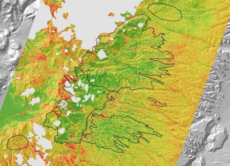
7 Vegetation Regeneration Monitoring North Zone: Rendija Canyon watershed and north 23,450 acres 11,200 acres attributed as high or moderate burn severity (48% of zone) South Zone: Pueblo Canyon watershed and south to include LANL 19,650 acres 6,700 acres attributed as high or moderate burn severity (34% of zone)

8 Landsat 7 ETM+ image acquired September 14, 2000, three months after containment. Clouds and shadows North Zone Los Alamos LANL South Zone

9 Prefire
10 2000
11 2001

12 2002

13 2003

14 2004

15 2005
16 Indices Used NDVI (Normalized Difference Vegetation Index) Highlights photosynthetic activity Calculated annually NRI (Normalized Regeneration Index) Compares NDVI values between fire and controls to quantify vegetation regeneration Calculated for inter-annual annual comparison Red NDVI = NIR Red + NIR NDVI fire NDVI control NRI = 1 + NDVI fire NDVI NDVI fire + NDVI NDVI control

17 NDVI Year to Year Controls Control Blues suggest more vibrant photosynthetic activity; tans suggest much less activity


18
 Inches 40 35 30 25 20 15 10 5 33.6 34.5 30.8 22.9 23.16 20.06 18 20.06 19.3 15.9 1 12.7 11.77 8.31 8.")
19 Precipitation Patterns Dry years stunt or may reverse regeneration Wet years may result in increased regeneration Quemezon NRCS SNOTEL (9500 ) LANL (TA-6) Climate Station (7424 ) Annual Precipitation (in) Inches Quemezon SNOTEL Los Alamos Average Los Alamos Climate Station Quemezon Average
20 NDVI Values for Entire Fire Cerro Grande NDVI Trends NDVI Values All Controls Fire NDVI Year Three years of below avg. precipitation
21 Treatments by NRI Zone Treatment* South North Total Aerial Seeding >6,700 >11,200 21,080 Aerial Hydromulch ,184 Contour Felling 1,823 1,316 3,139 Straw Wattles ,265 Grade Control Straw Mulch 2, ,704 Raking Treatment Totals 5,880 2,647 8,532 Total Mulch Acres 3, ,888 Acres In Perimeter 19,650 23,450 ~43,000 Acres High & Mod 6,700 11,200 ~17,900 % Mulch (H&M) *Channel treatments not included


22 South Mulch Acres: 3,049 North Mulch Acres: 839 Straw Mulch Aerial Hydromulch LANL Mulch LANL Aerial Hydromulch
23 NDVI Values By Zone Cerro Grande NDVI Trends NDVI Values Year South Zone NDVI North Zone NDVI All Controls Change in Annual NDVI Years Delta NDVI North dndvi South dndvi Control dndvi
24 NRI Trends Cerro Grande NRI Trends NRI Value South Zone North Zone Year Change in Annual NRI Years Delta NRI North dnri South dnri -0.04
25 Vegetation Recovery Discussion NDVI values differ due to differences in acres of high and moderate severity between zones Differences in landcover type distributions More P-J P J in north than south, for example Extent of treatments in each zone were different More mortality of remaining vegetation in north Higher % of mulch in the south (both rapid greening (2001) and browning (2002) see delta NRI) Precipitation patterns
 and 2001 Mulch Treatments (pink) Guaje Ridge 16 Guaje Canyon tree mortality Aerial hydromulch in Rendija Canyon as viewed from Guaje Ridge")

 8 4 Straw Mulch on Quemezon Trail (September 27, 2003) Straw mulch, June 2000 divide between Two Mile and Pajarito Canyons (August 14, 2003) (September 11, 2003) 3 14 N Straw mulch applied")
26 Cañon de Valle riparian scour Straw mulch applied July 2000, in south fork of Rendija Canyon (September 01, 2003) Ground Photo Monitoring 2003 BAER Treatments Cerro Grande Fire - Santa Fe National Forest NDVI Change with Aerial Hydromulch (blue) and 2001 Mulch Treatments (pink) Guaje Ridge 16 Guaje Canyon tree mortality Aerial hydromulch in Rendija Canyon as viewed from Guaje Ridge (September 20, 2003) Aerial hydromulch on north-facing slope of School Canyon (September 10, 2003) 1 Highly variable moisture conditions 12 Los Alamos Canyon riparian scour 15 Los Alamos Reservoir Los Alamos National Laboratory thinning New water tank Los Alamos County thinning Los Alamos Canyon tree mortality 12 Aerial hydromulch Los Alamos Canyon; top of slope above Los Alamos Reservoir (September 27, 2003) 2 13 M Straw mulch applied during July 2001, tributary to Los Alamos Canyon below Quemezon Trail Aerial hydromulch, July 2000, North Pueblo Canyon (Sept. 11, 2003) 8 4 Straw Mulch on Quemezon Trail (September 27, 2003) Straw mulch, June 2000 divide between Two Mile and Pajarito Canyons (August 14, 2003) (September 11, 2003) 3 14 N Straw mulch applied in Water Canyon, July 2000, above American Springs Road (September 22, 2003) Straw mulch, August 2001, North Pueblo Watershed (October 18, 2003) 6 9 Straw Mulch South Pueblo Canyon note oak in foreground (September 27, 2003) Raked and mulched, June 2000; headwaters of South Fork of Two Mile Canyon (August 14, 2003) Contour placed log in 2000 and straw mulch in 2001; along Pipeline Road (September 11, 2003) 4D 5 American Springs Road, July 2000; seeded, raked mulched, wattles and log erosion barriers (August 12, 2003) 7G 10 Aerial hydromulch above Los Alamos Reservoir (September 24, 2003) 15 O 16 Aerial seeding in 2000 on northfacing slope in Guaje Canyon (September 23, 2003) 8H 11 1 inch = 46 miles N 5: Photo ID; placement refers to approximate location of photo (August 12, 2003): Date photo was taken Unless treatments and / or recovery is occurring at a scale that can be delineated with 30 meter resolution specific correlations to Landsat NDVI are not possible. The classes depicted on the NDVI change map are based on a preliminary classification of the reflectance properties of the target area as recorded by a satellite sensor. The NDVI Change map is intended to support forest managers in their efforts to monitor vegetation recovery after a wildfire. This image map can be used to guide the assessment of vegetation conditions. This map may be modified by the field teams to represent actual ground conditions after proper field validation. Using this map for other than its intended purpose may yield inaccurate or misleading results. The USDA Forest Service uses the most current and complete data available during assessment of post-burn conditions. Geospatial data accuracy may vary. The USDA Forest Service reserves the right to correct, update, or modify geospatial inputs to this map without notification. For more information contact Jess Clark (jtclark@fs.fed.us) Greg Kuyumjian (gkuyumjian@fs.fed.us) USDA Forest Service Remote Sensing Application Center USDA Forest Service Santa Fe National Forest fsweb.rsac.fs.fed.us
27 Conclusions Inexpensive, repeatable, and objective Multiple customers Hydrologists, Soil Scientists, Foresters, etc. Visual tool for line officers and users RS provides information we can t see with our eyes RS is an element of analysis in conjunction with local knowledge and precipitation information
28 Questions For more information, please contact: Jess Clark Greg Kuyumjian
U.S. Forest Service Burned Area Emergency Response (BAER) Program
 Program") U.S. Forest Service Burned Area Emergency Response (BAER) Program Pre and Post Wildfire Conference Sacramento, CA Feb. 10, 2010 Brent Roath, Regional Soil Scientist/BAER Coordinator USFS, Pacific Southwest
U.S. Forest Service Burned Area Emergency Response (BAER) Program Pre and Post Wildfire Conference Sacramento, CA Feb. 10, 2010 Brent Roath, Regional Soil Scientist/BAER Coordinator USFS, Pacific Southwest
Mapping burn severity in heterogeneous landscapes with a relativized version of the delta Normalized Burn Ratio (dnbr)
") Mapping burn severity in heterogeneous landscapes with a relativized version of the delta Normalized Burn Ratio (dnbr) Jay D. Miller USDA Forest Service 3237 Peacekeeper Way McClellan, CA 95652 Email:
Mapping burn severity in heterogeneous landscapes with a relativized version of the delta Normalized Burn Ratio (dnbr) Jay D. Miller USDA Forest Service 3237 Peacekeeper Way McClellan, CA 95652 Email:
Comparison of Predicted and Observed Flood Flows in Pajarito Canyon Following the 2000 Cerro Grande Fire
 University of New Mexico UNM Digital Repository Water Resources Professional Project Reports Water Resources 12-12-2008 Comparison of Predicted and Observed Flood Flows in Pajarito Canyon Following the
Operational Monitoring of Alteration in Regional Forest Cover Using Multitemporal Remote Sensing Data ( )
") Operational Monitoring of Alteration in Regional Forest Cover Using Multitemporal Remote Sensing Data (2000-2003) Janet Franklin Doug Stow John Rogan Lisa Levien Chris Fischer Curtis Woodcock Consultant:
Operational Monitoring of Alteration in Regional Forest Cover Using Multitemporal Remote Sensing Data (2000-2003) Janet Franklin Doug Stow John Rogan Lisa Levien Chris Fischer Curtis Woodcock Consultant:
Hyde Park Hyde Park Wildland Urban Interface Project. Scoping Information February 2017
 Introduction The Santa Fe National Forest is working as part of the Greater Santa Fe Fireshed Coalition (GSFF) to change conditions across a landscape critical to the vitality of our communities. The GSFF
Forest Change Caused by Wind, Water, Ice, Fire, Insects/Disease & Harvesting
 Forest Change Caused by Wind, Water, Ice, Fire, Insects/Disease & Harvesting Why use remote sensing for mapping forest changes? Synoptic view of damage on a forest landscape or regional level. Can stop
Forest Service Angora Recovery Efforts. Eli Ilano Deputy Forest Supervisor Lake Tahoe Basin Management Unit USDA Forest Service November 3, 2007
 Forest Service Angora Recovery Efforts Eli Ilano Deputy Forest Supervisor Lake Tahoe Basin Management Unit USDA Forest Service November 3, 2007 Fire Facts Started June 24, 2007; Contained July 2; Controlled
Center Horse Landscape Restoration Project Summary Selected Action (Draft Record of Decision (DROD))
)") Center Horse Landscape Restoration Project Summary Selected Action (Draft Record of Decision (DROD)) The draft decision for the Center Horse Landscape Restoration Project is based on the information in
Center Horse Landscape Restoration Project Summary Selected Action (Draft Record of Decision (DROD)) The draft decision for the Center Horse Landscape Restoration Project is based on the information in
Everett A. Hinkley National Remote Sensing Program Manager
 USDA Forest Service Wildfire Support Programs Update GOFC-Fire IT Meeting October 2011 Everett A. Hinkley National Remote Sensing Program Manager USDA Forest Service / Geospatial Management Office Brad
Urban Ecosystem Analysis Roanoke, Virginia
 June 2002 Urban Ecosystem Analysis Roanoke, Virginia Calculating the Value of Nature Report Contents 2-3 Project Overview 4 Major Findings 5 Roanoke Area Green Data Layer 6 Tree Canopy Loss Over Time 7
Hayman Fire Rehabilitation Treatment Monitoring Progress Report
 Hayman Fire Rehabilitation Treatment Monitoring Progress Report Sediment yields, runoff, and ground cover in the first two years after the Hayman Fire P. Robichaud J. Wagenbrenner 7 March 2005 USD Forest
Watershed. Topography. Soil. Hydrology
 Watershed Topography The Egley Complex occurred within the Silver Creek watershed and Silvies River watershed both of which drain into the Oregon closed basins of Harney and Malheur Lakes. Most of the
Analysis of Vegetation Mortality and Prior Landscape Condition, 2002 Biscuit Fire Complex. Kirsten Harma and Peter Morrison
 Analysis of Vegetation Mortality and Prior Landscape Condition, 2002 Biscuit Fire Complex Kirsten Harma and Peter Morrison Pacific Biodiversity Institute February 14, 2003 Introduction The Biscuit Fire
Tracking Restoration Success
 Tracking Restoration Success A Presentation on Duette Preserve Environmental Monitoring Program Parks & Natural Resources Department Environmental Protection Division 1112 Manatee Avenue West, Suite 203
California Tahoe Conservancy Monitoring Plan
 California Tahoe Conservancy Monitoring Plan Acknowledgements University of California Cooperative Extension Expertise and time contributed Susie Kocher Richard Harris Gary Nakamura Mike De Lasaux United
Fires and Flash Flooding Federal Lands/Local Impact Waldo Canyon Fire Recovery Update: September Fall 2013
 Fires and Flash Flooding Federal Lands/Local Impact Waldo Canyon Fire Recovery Update: September 2013 Fall 2013 Started June 23, 2012, near Colorado Springs in western El Paso County Two people killed
Central Washington 2012 Wildfires Burned Area Emergency Response (BAER) Information Brief October 19, 2012 BAER Information: (208)
 Information Brief October 19, 2012 BAER Information: (208)") Okanogan-Wenatchee National Forest Central Washington 2012 Wildfires Burned Area Emergency Response (BAER) Information Brief October 19, 2012 BAER Information: (208) 398-3348 Fire Background WENATCHEE
Okanogan-Wenatchee National Forest Central Washington 2012 Wildfires Burned Area Emergency Response (BAER) Information Brief October 19, 2012 BAER Information: (208) 398-3348 Fire Background WENATCHEE
Remote Sensing for Fire Management
 Remote Sensing for Fire Management FOR 435/535: Remote Sensing for Fire Management 5. Severity A Source of Confusion Field Measures Remote Sensing Measures FOR 435: A Source of Confusion The terms fire
Emergency Stabilization, Rehabilitation, and Restoration
 Statement of Dr. Ann Bartuska Deputy Chief for Research and Development Forest Service; Mr. Steve Eubanks Forest Supervisor, Tahoe National Forest U.S. Department of Agriculture Before House Resources
Fire Management CONTENTS. The Benefits of Guidelines...3 Considerations...4
 Fire Management CONTENTS Fire Management 1 Introduction...3 The Benefits of Guidelines...3 Considerations...4 Planning...5 Burn Plan Development...5 Operational Activities...8 Pre-Ignition Activities...8
Remote Sensing Uses in Agriculture at NASS
 Remote Sensing Uses in Agriculture at NASS United States Department of Agriculture (USDA) National Agriculture Statistics Service (NASS) Research and Development Division Geospatial Information Branch
6. DOES THIS PROJECT PROPOSE FLOODPLAIN MODIFICATION? YES** NO If yes, then check all that apply:
 Case No.: (City use only) Environmental Resource Inventory For the City of Austin Relating to the Land Development Code (LDC) Section 5-8, Title 3-5, ECM 1.3. & 1.1. Effective October 8, 13 1. SITE/PROJECT
Integrated Landscape Monitoring: Prairie Pilot
 Integrated Landscape Monitoring: Prairie Pilot Prairie Pilot Science Team U.S. Department of the Interior U.S. Geological Survey JUSTIFICATION & NEED USDA Agency influences 400 million acres of cropland
Classification of Forest Dominate Types Using an Integrated Landsat and Ecological Model
 Classification of Forest Dominate Types Using an Integrated Landsat and Ecological Model Southern Region Existing Vegetation Mapping Pilot Project Test Supported By Region 8 Engineering/GeoSpatial 3 Year
Regional Ecosystem Analysis Puget Sound Metropolitan Area
 Final Report: 7/25/98 Regional Ecosystem Analysis Puget Sound Metropolitan Area Calculating the Value of Nature Report Contents 2 Project Overview and Major Findings 3 Regional Level Analysis 4 Neighborhood
Landsat 5 & 7 Band Combinations
 Landsat 5 & 7 Band Combinations By James W. Quinn Landsat 5 (TM sensor) Wavelength (micrometers) Resolution (meters) Band 1 0.45-0.52 30 Band 2 0.52-0.60
Acres within Planning Area. Total Acres Burned
 Calf-Copeland Project Description Figure 1: Dead sugar pine in the Calf-Copeland planning area. Sugar pine grow best in open conditions. In the absence of fire disturbance, high densities of Douglas-fir
Forest Restoration and Fire Prevention in the Lake Tahoe Basin
 Forest Restoration and Fire Prevention in the Lake Tahoe Basin Legislative Committee for the Review and Oversight of the Tahoe Regional Planning Agency (TRPA) and the Marlette Lake Water System January
A Report on the City of Lexington s Existing and Possible Urban Tree Canopy
 A Report on the City of Lexington s Existing and Possible Urban Tree Canopy Project Background Key Terms The analysis of Lexington s urban tree canopy (UTC) was carried out at the request of the Virginia
Using Imagery and LiDAR for cost effective mapping and analysis for timber and biomass inventories
 Using Imagery and LiDAR for cost effective mapping and analysis for timber and biomass inventories Mark Meade: CTO Photo Science Mark Milligan: President LandMark Systems May 2011 Presentation Outline
Stream Water Quality Concerns Linger Long After the Smoke Clears Learning from Front Range Wildfires
 Stream Water Quality Concerns Linger Long After the Smoke Clears Learning from Front Range Wildfires Chuck Rhoades, U.S. Forest Service, Rocky Mountain Research Station, Susan Miller, Freelance Science
30 Years of Tree Canopy Cover Change in Unincorporated and Incorporated Areas of Orange County,
 30 Years of Tree Canopy Cover Change in Unincorporated and Incorporated Areas of Orange County, 1986-2016 Final Report to Orange County July 2017 Authors Dr. Shawn Landry, USF Water Institute, University
Walton Lake Restoration Project
 Walton Lake Restoration Project Fire and Fuels Specialist Report, February 2017 Ochoco National Forest Lookout Mtn. Ranger District Barry Kleckler Fuels Specialist, Prairie Division, Central Oregon Fire
Water Yield in Thinned Stands: Observations from the Sierra Nevada
 Water Yield in Thinned Stands: Observations from the Sierra Nevada Roger Bales, UC Merced Topics in this talk Sierra Nevada hydrology Estimating evapotranspiration Drought impacts Thinning impacts Wildfire
Remote Measurements of Active Fire Behavior and Post-Fire Effects
 Remote Measurements of Active Fire Behavior and Post-Fire Effects Alistair Smith (and many many others ) Remote Sensing: A very Brief Overview ~ 5 million years B.C. : Humans Begin to Understand their
Mapping Forest Fire Burn Severity to Predict Vegetation Change and Carbon Dioxide Emissions: A Case Study from Alaska
 Mapping Forest Fire Burn Severity to Predict Vegetation Change and Carbon Dioxide Emissions: A Case Study from Alaska This lesson plan was developed by David Jakim and Dr. Jeffrey Bird from Queens College
Chapter 5 Changes to the Landscape of the Upper Gila River Watershed
 Chapter 5 Changes to the Landscape of the Upper Gila Watershed 5 Atlas of the Upper Gila Watershed Chapter 5 - Changes to the Landscape Section 5-1 Automated Geospatial Watershed Assessment (AGWA) Introduction
Remote Sensing (C) Team Name: Student Name(s):
 Team Name: Student Name(s):") Team Name: Student Name(s): Remote Sensing (C) Nebraska Science Olympiad Regional Competition Henry Doorly Zoo Saturday, February 27 th 2010 96 points total Please answer all questions with complete sentences
Team Name: Student Name(s): Remote Sensing (C) Nebraska Science Olympiad Regional Competition Henry Doorly Zoo Saturday, February 27 th 2010 96 points total Please answer all questions with complete sentences
ASSESSING THE STRUCTURE OF DEGRADED FOREST USING UAV
 ASSESSING THE STRUCTURE OF DEGRADED FOREST USING UAV STUDY CASE IN YUNGAS CLOUD FOREST, NORTH ARGENTINA Fernando Rossi 1, Andreas Fritz 2, Gero Becker 1, Barbara Koch 2 Albert-Ludwigs-Universität Freiburg
Restoration of Riparian Forests and Riparian Ecosystem Processes and Implications for Salmon Restoration. Katie Ross-Smith Jennifer Hammond
 Restoration of Riparian Forests and Riparian Ecosystem Processes and Implications for Salmon Restoration Katie Ross-Smith Jennifer Hammond Outline > Background California riparian communities Riparian
Rich Wildfire Fuel Treatment Effectiveness
 Rich Wildfire January 2009 Location Information Region: 05 Forest: Plumas District: Mount Hough Wildfire Information (consistent with 5100-29) Fire Number: CA-PNF-000784 Fire Name: Rich Fire Date of fire
Object-oriented Classification and Sampling Rate of Landsat TM Data for Forest Cover Assessment. Yasumasa Hirata 1, Tomoaki Takahashi 1
 Object-oriented Classification and Sampling Rate of Landsat TM Data for Forest Cover Assessment Yasumasa Hirata 1, Tomoaki Takahashi 1 1 Forest Management Department, Forestry and Forest Products Research
Mapping Coastal Great Lakes Wetlands and Adjacent Land use Through Hybrid Optical-Infrared and Radar Image Classification Techniques
 Mapping Coastal Great Lakes Wetlands and Adjacent Land use Through Hybrid Optical-Infrared and Radar Image Classification Techniques Laura L. Bourgeau-Chavez, Kirk Scarbrough, Mary Ellen Miller, Zach Laubach,
WATERSHED LAND COVER CHANGE IN GUAM. Yuming Wen Shahram Khosrowpanah Leroy F. Heitz
 WATERSHED LAND COVER CHANGE IN GUAM Yuming Wen Shahram Khosrowpanah Leroy F. Heitz Technical Report No. 124 March 2009 Watershed Land Cover Change in Guam by Yuming Wen Shahram Khosrowpanah Leroy F. Heitz
Serving raster data through enterprise systems USDA Forest Service. Esri conference July 23 rd, Dave Vanderzanden
 Serving raster data through enterprise systems USDA Forest Service Esri conference July 23 rd, 2015 Dave Vanderzanden Enterprise Data and Services Program Leader 801-975-3753 dvanderzanden@fs.fed.us Remote
Past Meets the Present: Using Old Burns in Fire Management
 Past Meets the Present: Using Old Burns in Fire Management Using previous burned areas in fire management has long been an important part of the strategies and tactics used by fire crews. However, with
CHAPTER 7 PHYSICAL INVENTORY OF THE CITY
 CHAPTER 7 PHYSICAL INVENTORY OF THE CITY Chapter 7: Physical Inventory of the City 39 This page intentionally left blank. Chapter 7: Physical Inventory of the City 40 SECTION 1 PHYSICAL SETTING While communities
Appendix D: Analysis for Detrimental Soil Disturbance and Total Soil Resource Commitment. Becker Integrated Resource Project
 Appendix D: and Total Soil Resource Commitment Becker Integrated Resource Project This page intentionally left blank Appendix D Detrimental Disturbance (USDA Forest Service 2010a, p. GL-10) Detrimental
Nez Perce National Forest Moose Creek Ranger District
 United States Department of Agriculture Forest Service Nez Perce National Forest Moose Creek Ranger District 831 Selway Road Kooskia, ID 83539 208 926-4258 TTY 208 926-7725 File Code: 1950 Date: Dec 30,
Monitoring Trends in Burn Severity (MTBS) Project Overview
 Project Overview") Monitoring Trends in Burn Severity (MTBS) Project Overview Adrian Grell US Forest Service Remote Sensing Applications Center Webinar for the Northern Rockies Fire Science Network February 6, 2013 Consistently
Monitoring Trends in Burn Severity (MTBS) Project Overview Adrian Grell US Forest Service Remote Sensing Applications Center Webinar for the Northern Rockies Fire Science Network February 6, 2013 Consistently
Wildfires in the Western Boreal:
 Wildfires in the Western Boreal: Chicken or Egg? Boreal Mixedwoods 2012 Conference June 18, 2012 Edmonton, Alberta David Andison Bandaloop Landscape Ecosystem Services Wildfire Event = The general area
A Report on the City of Chesapeake s Existing and Possible Urban Tree Canopy
 A Report on the City of Chesapeake s Existing and Possible Urban Tree Canopy Project Background The analysis of Chesapeake s urban tree canopy (UTC) was carried out at the request of the Virginia Department
Low-intensity fire burning on the forest floor. High-intensity crown fire
 Forest Fires: Answers to 12 Common Questions 1. Is wildfire bad for forests? No. Some forests need fire to be healthy, but it has to be the type of fire that the forest evolved with. Low-intensity fire
Mixed Conifer Working Group Meeting April 15, 2011 Water and Soil Resource Management Considerations
 Mixed Conifer Working Group Meeting April 15, 2011 Water and Soil Resource Management Considerations It is difficult to tie watershed health directly to mixed-conifer forests. Watersheds encompass a variety
COMMUNITY WILDFIRE PROTECTION PLAN 2016 LOS ALAMOS, NEW MEXICO
 COMMUNITY WILDFIRE PROTECTION PLAN 2016 LOS ALAMOS, NEW MEXICO COMMUNITY WILDFIRE PROTECTION PLAN 2015 TABLE OF CONTENTS STATEMENT OF PURPOSE STAKEHOLDER ENGAGEMENT: PUBLIC MEETINGS, CORE TEAM MEETINGS
Joshua J. Picotte Dr. Kevin Robertson
 Validation of National Burn Severity Mapping Project Techniques Within the Apalachicola National Forest Joshua J. Picotte Dr. Kevin Robertson Project Overview Background Project Questions Results Problems
Appendix J. Forest Plan Amendments. Salvage Recovery Project
 Forest Plan Amendments Salvage Recovery Project APPENDIX J Lynx and Old Growth Forest Plan Amendments CHANGES BETWEEN DRAFT EIS AND FINAL EIS Changes in Appendix J between the Draft and Final EIS include:
Why Wildfires Keep Getting Bigger: An Introduction to Wildland Fires in New Mexico. Mary Stuever, Chama District Forester New Mexico State Forestry
 Why Wildfires Keep Getting Bigger: An Introduction to Wildland Fires in New Mexico Mary Stuever, Chama District Forester New Mexico State Forestry Visiting Forester Program at Philmont Scout Ranch William
Site Preparation: The First Step to Regeneration
 Site Preparation: The First Step to Regeneration People have been clearing land for agricultural purposes for centuries. They recognized early that weeds, brush, and stones had to be removed if crops were
Fire & Fuels Management
 Overview Fire & Fuels Management Southern California Adaptation Implementation Plan During a two- day workshop in January 2016, southern California resource managers and regional stakeholders discussed
PRECISION AGRICULTURE SERIES TIMELY INFORMATION Agriculture, Natural Resources & Forestry
 PRECISION AGRICULTURE SERIES TIMELY INFORMATION Agriculture, Natural Resources & Forestry March 2011 Management Zones II Basic Steps for Delineation Management zones (MZ) support site specific management
Statement of. Dale Bosworth, Chief U.S. Forest Service United States Department of Agriculture
 Statement of Dale Bosworth, Chief U.S. Forest Service United States Department of Agriculture Before the House Resource Committee Subcommittee on Forests and Forest Health U.S. House of Representatives
PROJECT HIGHLIGHTS,
 PROJECT HIGHLIGHTS, 2012-003 935 linear feet of fence encompassing livestock pond 1 water tank, 2 water troughs, 3800 linear feet pipeline Project: 2012-003 Watershed: Tomales Bay, East Shore Practices:
Estimating Soil Carbon Sequestration Potential: Regional Differences and Remote Sensing
 Estimating Soil Carbon Sequestration Potential: Regional Differences and Remote Sensing Tris West Environmental Sciences Division Technical Working Group on Agricultural Greenhouse Gases (T-AGG): Experts
Whitewater Baldy Fire - by Jose Iniguez
 Whitewater Baldy Fire - by Jose Iniguez If you attended the AFE conference last March and went on the Los Conchas field trip you may remember hearing that managers in the Jemez Mountains were actually
Using Open Data and New Technology To Tackle the Greening of the CAP from a broader perspective
 Using Open Data and New Technology To Tackle the Greening of the CAP from a broader perspective Prague, 21 st of October Marcel Meijer & Jeroen van de Voort Outline Setting the scene Open Data related
Post-Fire BAER Assessment Burned Area Emergency Response (BAER)
") November 2017 Post-Fire BAER Assessment Burned Area Emergency Response (BAER) Information Brief Diamond Creek Fire Values at Risk Matrix and Treatments CentralWashingtonFireRecovery.info EMERGENCY DETERMINATION
November 2017 Post-Fire BAER Assessment Burned Area Emergency Response (BAER) Information Brief Diamond Creek Fire Values at Risk Matrix and Treatments CentralWashingtonFireRecovery.info EMERGENCY DETERMINATION
Detection of Deforestation in China and South East Asia using GF-1 time-series Data
 Detection of Deforestation in China and South East Asia using GF-1 time-series Data Project No.10549 Dr. Tan Bingxiang, Institute of Forest Resources Information Technique, CAF, Beijing, China Mike Wooding,
Scenery Report Salmon Reforestation Project
 United States Department of Agriculture Forest Service May 12, 2014 Scenery Report Salmon/Scott River Ranger District, Klamath National Forest Siskiyou County, California For Information Contact: Bob Talley
Walla Walla Ranger District
 United States Department of Agriculture Forest Service Walla Walla Ranger District 1415 West Rose Walla Walla, WA 99362 509-522-6290 File Code: 1950 Date: September 30, 2014 Dear Forest User: The Walla
Cost share summary. Activities are for areas that are not a part of a THP area Could this be THE KICK YOU HAVE BEEN WAITING FOR?
 Cost share summary For help with the non-commercial activities that you have always wanted to do Or for times of real emergency following postwildlfire events Activities are for areas that are not a part
The Use of Remotely-Sensed Imagery to Analyze Vegetation Cover in Pinyon and Juniper Woodlands
 The Use of Remotely-Sensed Imagery to Analyze Vegetation Cover in Pinyon and Juniper Woodlands April Hulet, Bruce A. Roundy, Steven L. Petersen, Ryan R. Jensen, and Stephen C. Bunting Land managers in
Role and importance of Satellite data in the implementation of the COMIFAC Convergence Plan
 Plenary Meeting of the Congo Basin Forest Partnership (CBFP) Palais des Congrès, Yaoundé. Cameroon 11-12 November, 2009 Role and importance of Satellite data in the implementation of the COMIFAC Convergence
Attachment C Applicant s Proposed Mitigation Statement Alaska DOT&PF Northern Region Pilot Station Airport Relocation Project POA
 Attachment C Applicant s Proposed Mitigation Statement Alaska DOT&PF Northern Region Pilot Station Airport Relocation Project POA-2004-1223 Introduction This mitigation statement was prepared as an attachment
A Hydrologic Study of the. Ryerson Creek Watershed
 A Hydrologic Study of the Ryerson Creek Watershed Dave Fongers Hydrologic Studies Unit Land and Water Management Division Michigan Department of Environmental Quality May 8, 2002 Table of Contents Summary...2
RIM FIRE Preliminary Fuel Treatment Effectiveness Report
 RIM FIRE Preliminary Fuel Treatment Effectiveness Report USDA Forest Service, Pacific Southwest Region, Stanislaus National Forest DOI National Park Service, Pacific West Region, Yosemite National Park
Exploring the Possibilities At Prado Dam
 Exploring the Possibilities At Prado Dam Greg Woodside, P.G., C.HG. Executive Director of Planning & Natural Resources December 5, 2017 The Orange County groundwater basin lies at the base of the Santa
Application of remote sensing by the New Zealand forest industry. Aaron Gunn
 Application of remote sensing by the New Zealand forest industry Aaron Gunn Presentation Overview History LiDAR Cluster Group Personal Experience - Blakely Pacific Ltd (silvicultural scheduling) Remote
1. Protect against wildfires 2. Enhance wildlife habitat 3. Protect watersheds 4. Restore plant communities. Ford Ridge Project Area (pre-treatment)
") OVERVIEW Ford Ridge is a multi-stage project planned and coordinated utilizing indepth scientific research and best management practices. Project implementation began in the spring of 2015, with additional
OVERVIEW Ford Ridge is a multi-stage project planned and coordinated utilizing indepth scientific research and best management practices. Project implementation began in the spring of 2015, with additional
2002 Rodeo-Chediski Wildfire Survival of Springs. Daniel Pusher, White Mountain Apache Tribe Water Resources Program
 2002 Rodeo-Chediski Wildfire Survival of Springs Daniel Pusher, White Mountain Apache Tribe Water Resources Program PURPOSE Emphasize importance of watershed protection & preservation: Identification Reconnaissance
A Report on the City of Newport News Existing and Possible Urban Tree Canopy
 A Report on the City of Newport News Existing and Possible Urban Tree Canopy Key Terms UTC: Urban tree canopy (UTC) is the layer of leaves, branches, and stems of trees that cover the ground when viewed
Four Forest Restoration Initiative
 Four Forest Restoration Initiative OVERVIEW, STATUS AND WATERSHED CONSIDERATIONS F E B R U A R Y 3 RD, 2 0 1 2 L C R WINTER WATERSHED C O N F E R E N C E S H A R O N M A S E K L O P E Z NAU Departure from
Soil Erosion and Sedimentation Control Application Packet 2011
 Soil Erosion and Sedimentation Control Application Packet 2011 The following items are required to apply for a Soil Erosion and Sedimentation Control permit for a construction project in Chippewa County:
MONITORING TRENDS AND BURN SEVERITY (MTBS): MONITORING WILDFIRE ACTIVITY FOR THE PAST QUARTER CENTURY USING LANDSAT DATA
: MONITORING WILDFIRE ACTIVITY FOR THE PAST QUARTER CENTURY USING LANDSAT DATA") MONITORING TRENDS AND BURN SEVERITY (MTBS): MONITORING WILDFIRE ACTIVITY FOR THE PAST QUARTER CENTURY USING LANDSAT DATA Mark Finco, Brad Quayle, Yuan Zhang, Jennifer Lecker, Kevin A. Megown, and C. Kenneth
MONITORING TRENDS AND BURN SEVERITY (MTBS): MONITORING WILDFIRE ACTIVITY FOR THE PAST QUARTER CENTURY USING LANDSAT DATA Mark Finco, Brad Quayle, Yuan Zhang, Jennifer Lecker, Kevin A. Megown, and C. Kenneth
Fire Regimes and Vegetation
 Fire Regimes and Vegetation in the Greater Blue Mountains World Heritage Area Dr EM Tasker & Dr KA Hammill Fire Ecology Unit Scientific Services Division NSW OEH Photo: Ian Brown 1 Greater Blue Mountains
To provide timely, accurate, and useful statistics in service to U.S. agriculture
 NASS MISSION: To provide timely, accurate, and useful statistics in service to U.S. agriculture What does NASS do? Administer USDA s Statistical Estimating Program Conduct the 5-year Census of Agriculture
Dear Interested Party:
 United States Department of Agriculture Forest Service Beaverhead-Deerlodge National Forest 420 Barrett Street Dillon, MT 59725 406 683-3900 File Code: 1950 Date: June 7, 2011 Dear Interested Party: Thank
This document is for review purposes only. Do Not Distribute. (c) Esri Press. us department of agriculture
 Esri Press. us department of agriculture") us department of agriculture Putting our data on these maps within our existing systems is a really, really big deal for us. Just clicking on a map is a more intuitive way for us to understand and to explore
us department of agriculture Putting our data on these maps within our existing systems is a really, really big deal for us. Just clicking on a map is a more intuitive way for us to understand and to explore
Public Utilities and Innovative Payments For Watershed Services Programs
 Public Utilities and Innovative Payments For Watershed Services Programs Drew Bennett*, College of Earth, Ocean and Atmospheric Sciences Sally Duncan, School of Public Policy Sue Lurie, Institute for Natural
Rapid Land Use and Land Cover Database Development
 Rapid Land Use and Land Cover Database Development Utility of the Land Use and Land Cover Database Socio-Economic Climate Change Water Quantity Water Quality 2 Overview of the Mapping Approach Goal: Develop
Existing Land Use USACE Fountain Creek Watershed Study Watershed Management Plan, Pueblo
 Existing Land Use USACE Fountain Creek Watershed Study Watershed Management Plan, 2009 Pueblo N Future Land Use (2025) USACE Fountain Creek Watershed Study Watershed Management Plan, 2009 Pueblo N Project
Identifying and and Understanding Carbon Cycle Implications of of North American Natural and and Anthropogenic Disturbances:
 Identifying and and Understanding Carbon Cycle Implications of of North American Natural and and Anthropogenic Disturbances: 1982-2005 Progress Progress Report Report NRA-04-OES-01 NRA-04-OES-01 Christopher
FIRE ECOLOGY AND RESTORATION IN THE SOUTH LLANO WATERSHED Gary Garrett, Texas Parks & Wildlife
 FIRE ECOLOGY AND RESTORATION IN THE SOUTH LLANO WATERSHED Gary Garrett, Texas Parks & Wildlife The Texas Parks and Wildlife Department and the South Llano Watershed Alliance convened a workshop of 25 experts
Designing Fuel Treatments to Modify Landscape Level Fire Behavior Carl N. Skinner
 Designing Fuel Treatments to Modify Landscape Level Fire Behavior Carl N. Skinner Science Team Leader Pacific Southwest Research Station Redding, CA Environmental Controls on Fire Regimes Climate Substrate
A Report on the City of Richmond s Existing and Possible Urban Tree Canopy
 A Report on the City of Richmond s Existing and Possible Urban Tree Canopy Key Terms UTC: Urban tree canopy (UTC) is the layer of leaves, branches, and stems of trees that cover the ground when viewed
Part 3: Effects of Fuel Treatments on Fire Severity
 Part 3: Effects of Fuel Treatments on Fire Severity Erik Martinson, Phillip N. Omi, Wayne Shepperd Summary The role played by the fuel conditions within the Hayman Fire severity was complex and does not
Remote sensing applications in natural resources mapping and management An Indian Context
 Remote sensing applications in natural resources mapping and management An Indian Context International Workshop on Operational Mapping/Monitoring of Agricultural Crops in South/Southeast Asian Countries
2-16 EROSION, SEDIMENT & STORM WATER CONTROL REGULATIONS APPENDIX B1
 2-16 EROSION, SEDIMENT & STORM WATER CONTROL REGULATIONS APPENDIX B1 There are three ways to accomplish urban soil erosion and sedimentation control: Allow erosion to take place and then control sediment
A Report on the City of Radford s Existing and Possible Urban Tree Canopy
 A Report on the City of Radford s Existing and Possible Urban Tree Canopy Project Background Key Terms The analysis of Radford s urban tree canopy (UTC) was carried out at the request of the Virginia Department