Dynamique hydrolog ique, s édimentaire et g éochimique des zones d inondation en Amazonie: résultats et perspectives
|
|
|
- Brandon Evans
- 6 years ago
- Views:
Transcription


1 Dynamique hydrolog ique, s édimentaire et g éochimique des zones d inondation en Amazonie: résultats et perspectives 1
 (Martinez et al.")
2 Floodplain surface area estimation for the whole Amazon basin: between 3, and 6, km² (±67,) (Martinez et al.,27) 6 km 2

3 Floodplain and River interactions Landsat Image, High waters (8/July/21) Role of floodplains: attenuation of floods zone of sediment deposition modification of water chemistry (sorption & redox processes) 3
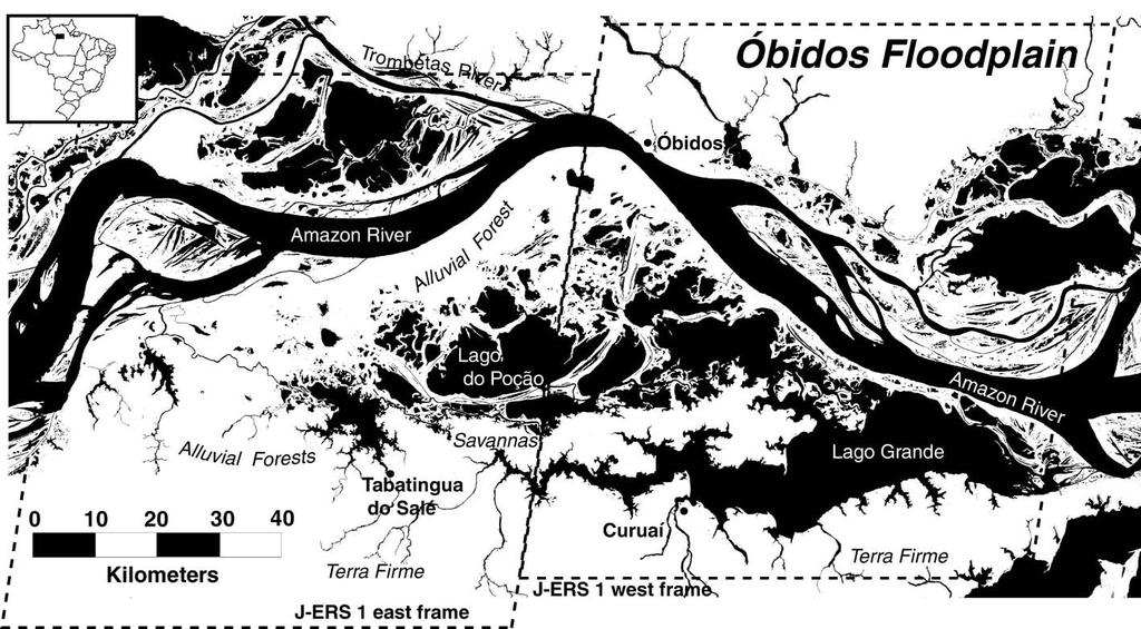
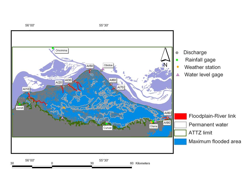
4 Study area: The Curuaí floodplain Location: W / 2.18 S System size: 126 x 2 km Iquitos U % # U % # U % # Manaus Santarem - N W Km S River level fluct. River slope : 7m : 1.4 cm.km-1 Watershed Area E Altitude (m) OCEAN -2 : 366 km² 4
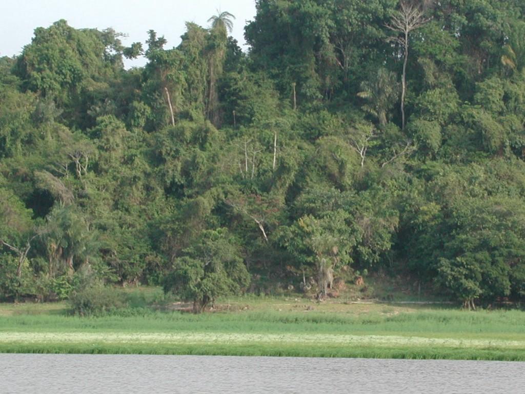
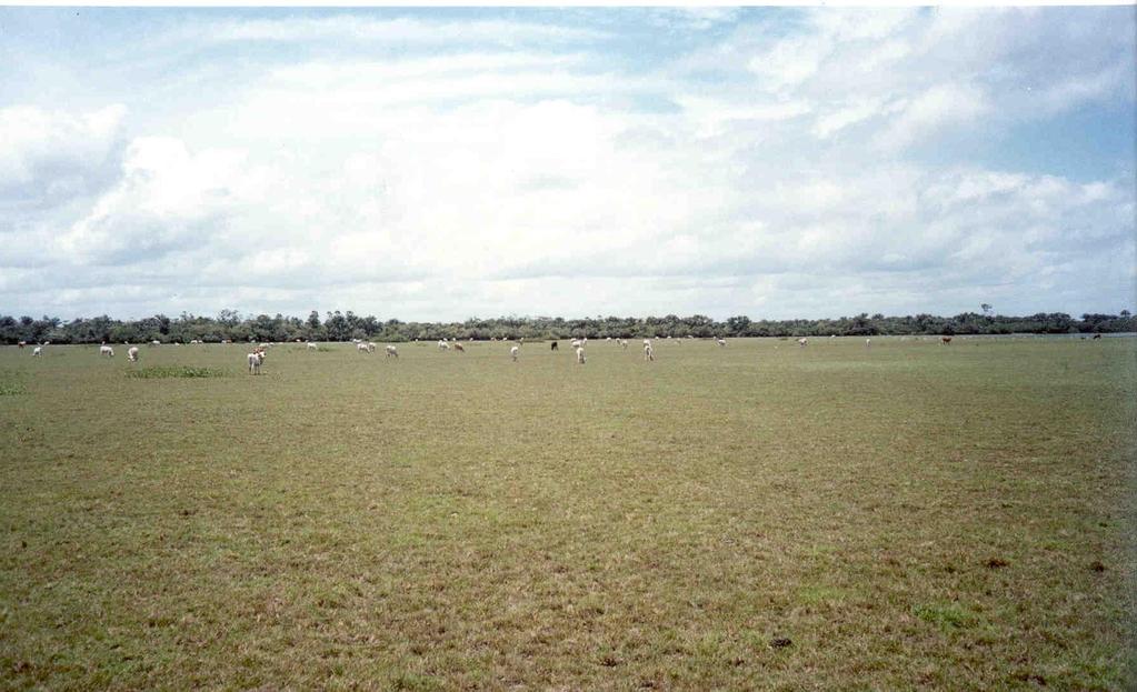

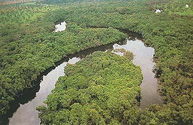
5 Riverbank Aquatic-Terrestrial Transition zone Local Watershed 5
6 Methodology 6
7 Várzea lake hydrological modeling :Available data Bathymétrie No Data Surface-water level relationship 3 N Kilometers W S 2 (km²) SRTM + MOSAIC JERS DEM => relationship between the inundated surface area and water level 2 Flooded area: 575/243km Aquatic Terrestrial Transition Zone: /1855 km2 E (m) S=(216 ± 9.2)(Z-Z )+(551±46)7 12.5
 Discharge m.s 4 2 5 5. 7.5 1 Water level (m) 12.")
8 Várzea lake modeling: available data for water discharge $ AI3 AI2$ $ $ AI $$$ $ AI7 $ $ $ AI8 $$ ATS AC Width (m) 3 19 déc Width Depth Max. depth(m) Discharge m.s Water level (m) Water level (m)
9 Várzea lake modeling: available data for rainfall -1 mm.day Annual rainfall (mm) Humid year 3 Curuai 25 Orixima 2 Juruti 15 Obidos around the varzea lake Rainfall recorded at 4 rain gauge stations Time Dry year Water year 9 76-year average of rainfall
10 Várzea lake modeling: available data for evaporation 5 Riou, 75 (Empirical transfert de masse formula) 4.5 Mass transfer (Dalton law) mm.j mars févr janv déc Good agreement between the 2 formulas Seasonal variations of evaporation are weak. Evaporation accounts for 5 to 73 % of rainfall. nov oct sept août juil juin mai avr mars
11 Várzea lake modeling: Analyses procedure Channel Local runoff Bank overflow Rainfall/evaporation AI2 Bank seepage Heva Model Rainfall t+ 1 L V Evaporation = V + QR QE + QWN + QWS ± QG ± t L Runoff from the aquatic-terrestrial transition 19 déc. 27zone QwN = Max( ( P E )( S BVN S L ),) Upland local discharge i Qci t Groundwater flow from bank-seepage dh dx K=-2m.s-1 QG = KL * dz Amazon- varzea channels discharge 11
12 Várzea lake modeling: Analyses procedure At each step of time Δt (daily time step) the hydrological mass balance is expressed as: t+ 1 L V = V + QR QE + QWN AI3 + QWS ± QG ± AI2 t L i Qci t B = Qci + QR + QwN + QwS ± QG QE i Evaporation Amazon- varzea channels discharge Rainfall Runoff from the aquatic-terrestrial transition zone Groundwater flow from bank-seepage dh dx K=-2m.s-1 QG = KL * dz QwN = Max( ( P E )( S BVN S L ),) Upland local discharge 12
13 Model calibration and validation Computed and measured water levels at Curuai station 12 measured computed.3.1 cm 8 Water level (m) Differences between observed and computed values calibratio n validation Sep-3 Mar-3 Sep-2 Mar-2 Sep-1 Mar-1 Sep- Mar- Sep-99 Mar-99 Sep-98 Mar-98 Sep-3 Mar-3 Sep-2 Mar-2 Sep-1 Mar-1 Sep- Mar- Sep-99 Mar-99 Sep-98 Mar-98 Sep-97 Sep-97 validation Time mean absolute differences and standard deviations:
14 wn G Month Month P wn VL 4 3) QG 6 I 5 QE 8 in 4 QwS 3) Cumulative fluxes (km QwN 7.5 in Volume (km I-O V/Σ Volume (km 2 Σ 3 3) QP b a Fraction of each source term Cumulative volume and fraction of the water flux components Month year (regular year) 11-6 Groundwater related flux 14
15 P wn 6 2 wn G Net contribution from the floodplain to the river: 6.7 km3 9 8 Month Month = 95% = 4% = 1% VL in I 2-2 Σ 3) Sink terms: Amazone River Evaporation 2.5 Seepage.5 b = 78% V=/Σ9% in = 5% = 5% =3% 1 3) 3) Cumulative fluxes (km Volume (km I-O 1-2 Volume (km a Source terms: Amazone River Q DirectP rainfall 7.5 Local QwS water basin QwN Runoff on ATTZ QE Seepage QG Fraction of each source term Cumulative volume fluxes of the water Monthflux year (regular year)
16 Cumulative volume related to source and sink terms for the 6 water years study 3 year Inflow Average SD % Source terms (km ) Rainfall Runoff wn Runoff ws Seepage Sink terms (km3) Outflow Evaporation Seepage Water mass balance (km3) Ra Rw m SD % m SD % m SD % m SD % m SD % m SD % m SD % m SD % m SD % m SD %
17 Inter-annual variation: temporal mixture in the lake Day Groundwater G& bank seepage Day in Day /Σ Mixture Vfrom year-1.3 Day I ws Local Basin discharge.4 Days wn Runoff ATTZ P Rainfall I Inflow Amazon 1. Day
18 Inter-annual variation: temporal mixture in the lake G 6 Day in 1. Day Day V/Σ Day I ws Days Input from the groundwater system represents between 7 and.3 times (1 and 5%) the maximum volume of stored water in the floodplain system. 3 Local Basin The discharge Curuai floodplain contributes to 9.3 km Mixture from year for 6.3 Groundwater & bank seepage to the Amazon flow Mean water residence time is about 3 ± months wn ATTZ Runoff P Rainfall.4 1. I Inflow Amazon 1. Day Bonnet et al., in press 18
19 Suspended solids mass balance 4 12 Flux liquide net (Mm3) Flux solide net (^3 t) Flux entrant 3 Cote Amazone 2 8 Flux sortant Nov-3 Sep-3 Jul-3 May-3 Mar-3 Jan-3 Nov-2 Oct-2 Aug-2 Jun-2 Apr-2 Feb-2 Dec-1 Oct-1 Aug-1 Jun-1 Apr-1 Feb-1-6 Dec- (cm) Une forte remise en suspension en période de basse eaux Un stockage de sédiment entre 14 et 5% des flux entrant Un taux d accrétion de 1 à 2 mm par an -4 Bourgoin et al.,
20 Bilan de certains éléments chimiques K T/an Ca T/an Sr T/an Mn T/an Fe T/an Ba T/an Cu T/an U T/an Q 3 m /s Flux moyen entrant dans la varzéa Flux moyen sortant de la varzéa Bilan de transfert Temps de résidence dans la varzéa pour le cycle (jours) Barroux, 26 A l échelle annuelle, seuls le Mn et le Fe semblent non conservatifs 2
21 Variations saisonnières de Ca2+ 2 Recharge par la nappe ou dégradation de la 15 végétation RCa 5 Uptake par la végétation Sale -5 Em Ec R= cl Comparaison du comportement du chlore (conservatif) avec celui du Ca2+ 21


22 Primary production in floodplains and impact on CO2 emission Lago de Curuai Lago de Janauaca about 16 km² Solimoes floodplain Clear and black waters Objectives : To quantify primary production and it s controlling factors in floodplains To track primary production fate and evaluate it s impact on CO2 emissions Method: Study of two contrasted sites to help extrapolation : Method based on in situ survey, water color and modelling program EC2CO 27 22

23 Thanks for your attention! 23
Effect of exceptional hydrological events of the Solimões River on the hydrology and physico chemistry of a floodplain lake Part 1: Hydrology
 Effect of exceptional hydrological events of the Solimões River on the hydrology and physico chemistry of a floodplain lake Part 1: Hydrology Bonnet, MP. 1, Lamback, B 2, Oliveira, E. 2, Boaventura, G.
Impact of snow melt on the hydrologic and water resources systems, Lebanon
 Snow cover dynamics and snow hydrology of the Lebanese Mountain Chains Using an integrated remote sensing and hydrologic modeling approach Impact of snow melt on the hydrologic and water resources systems,
The Impact of Climate Change on a Humid, Equatorial Catchment in Uganda.
 The Impact of Climate Change on a Humid, Equatorial Catchment in Uganda. Lucinda Mileham, Dr Richard Taylor, Dr Martin Todd Department of Geography University College London Changing Climate Africa has
July, International SWAT Conference & Workshops
 Analysis of the impact of water conservation measures on the hydrological response of a medium-sized watershed July, 212 212 International SWAT Conference & Workshops ANALYSIS OF THE IMPACT OF WATER CONSERVATION
How to model water quality using SWAT model in the Amazon catchment?
 6 ème réunion scientifique du SO HYBAM 26-3 Octobre- Cuzco- Pérou How to model water quality using SWAT model in the Amazon catchment? SAUVAGE, S., SANCHEZ-PEREZ J.M., With the collaboration of SANTINI
Isotopic Composition of Mansar Lake, District. Significance in Hydrological Investigations. S.P. Rai, Scientist, C
 Isotopic Composition of Mansar Lake, District Udhampur, Jammu & Kashmir and Its Significance in Hydrological Investigations S.P. Rai, Scientist, C Bhishm h Kumar, Scientist, i F Omkar Singh, Scientist,
Lake of the Woods TMDL: Update and Next Steps November 21, 2017
 Lake of the Woods TMDL: Update and Next Steps November 21, 2017 Outline Where we ve been (2016) HSPF Bathtub Internal loading estimation Progress in 2017 Development of TMDL load allocation table Next
Chapter 1 Introduction
 Engineering Hydrology Chapter 1 Introduction 2016-2017 Hydrologic Cycle Hydrologic Cycle Processes Processes Precipitation Atmospheric water Evaporation Infiltration Surface Runoff Land Surface Soil water
Assessment of sediment and carbon flux in a tropical watershed: the Red River study case (China and Vietnam)
") Assessment of sediment and carbon flux in a tropical watershed: the Red River study case (China and Vietnam) Xi WEI Supervisors: Sabine SAUVAGE, Jose-Miguel SANCHEZ-PEREZ, Thi Phuong Quynh LE 2 th September
Assessment of sediment and carbon flux in a tropical watershed: the Red River study case (China and Vietnam) Xi WEI Supervisors: Sabine SAUVAGE, Jose-Miguel SANCHEZ-PEREZ, Thi Phuong Quynh LE 2 th September
Exploring the Possibilities At Prado Dam
 Exploring the Possibilities At Prado Dam Greg Woodside, P.G., C.HG. Executive Director of Planning & Natural Resources December 5, 2017 The Orange County groundwater basin lies at the base of the Santa
Lecture 9A: Drainage Basins
 GEOG415 Lecture 9A: Drainage Basins 9-1 Drainage basin (watershed, catchment) -Drains surfacewater to a common outlet Drainage divide - how is it defined? Scale effects? - Represents a hydrologic cycle
Hydrological drivers of organic matter quality, mineralization and export in a tropical dam-impacted floodplain system
 Hydrological drivers of organic matter quality, mineralization and export in a tropical dam-impacted floodplain system Roland Zurbrügg Acknowledgements: Stephan Suter, Bernhard Wehrli, David B. Senn Institute
Wetland Water Balance Linking hydrogeological processes to ecological effect
 Wetland Water Balance Linking hydrogeological processes to ecological effect Don Ross & David Gasca Outline Background Wetland-scale processes Water balance approach Hydrogeological inputs & ecological
Assessment of impacts of climate change on runoff: River Nzoia catchment, Kenya. Githui F. W, Bauwens W. and Mutua F.
 Assessment of impacts of climate change on runoff: River Nzoia catchment, Kenya by Githui F. W, Bauwens W. and Mutua F. Objective To investigate the impact of climate change on runoff of Nzoia river catchment
City of San Clemente Water Usage Report
 Monthly Usage (AF) ACRE FEET City of San Clemente Overview of Usage FY 217-18 Monthly Water Use Type of Supply Total MWDOC 723 722 657 629 - - - - - - - - 2,731 Local Groundwater 33 23 69 84 - - - - -
Current Water Management Practices for Kerr Reservoir
 Current Water Management Practices for Kerr Reservoir Ashley Hatchell Water Management Lake Gaston Association Monthly Meeting 03 February 2016 US Army Corps of Engineers Outline and Goals for Today s
Overview of the Surface Hydrology of Hawai i Watersheds. Ali Fares Associate Professor of Hydrology NREM-CTAHR
 Overview of the Surface Hydrology of Hawai i Watersheds Ali Fares Associate Professor of Hydrology NREM-CTAHR 5/23/2008 Watershed Hydrology Lab 1 What is Hydrology? Hydrology is the water science that
Application of a Basin Scale Hydrological Model for Characterizing flow and Drought Trend
 Application of a Basin Scale Hydrological Model for Characterizing flow and Drought Trend 20 July 2012 International SWAT conference, Delhi INDIA TIPAPORN HOMDEE 1 Ph.D candidate Prof. KOBKIAT PONGPUT
Water budget monitoring of irrigated perimeters in semi-arid areas using high resolution NDVI image time series.
 Water budget monitoring of irrigated perimeters in semi-arid areas using high resolution NDVI image time series. Application for the assessment of groundwater extraction Simonneaux V., Saadi S., Boulet
Integrating wetlands and riparian zones in regional hydrological modelling
 Integrating wetlands and riparian zones in regional hydrological modelling Fred Hattermann, Valentina Krysanova & Joachim Post Potsdam Institute for Climate Impact Research Outline Introduction Model concept:
dissolved fraction particulate fraction Resuspension
 CE4505 SURFACE WATER QUALITY PROJECT 2B. TORCH LAKE RECOVERY MODEL Due 10/29/09 The model that we will use for the next week is shown in Fig. 1 below. This model is a simplification of reality in two major
Climate Change Considerations for Surface Water and Groundwater Flows in the Everglades
 Climate Change Considerations for Surface Water and Groundwater Flows in the Everglades Robert Johnson National Park Service/ENP Hydrology of the Everglades in the Context of Climate Change March 30, 2012
Hydrological And Water Quality Modeling For Alternative Scenarios In A Semi-arid Catchment
 Hydrological And Water Quality Modeling For Alternative Scenarios In A Semi-arid Catchment AZIZ ABOUABDILLAH, ANTONIO LO PORTO METIER Final Conference: Brussels, Belgium-4-6 November 2009 Outline Problem
Sixth Semester B. E. (R)/ First Semester B. E. (PTDP) Civil Engineering Examination
/ First Semester B. E. (PTDP) Civil Engineering Examination") CAB/2KTF/EET 1221/1413 Sixth Semester B. E. (R)/ First Semester B. E. (PTDP) Civil Engineering Examination Course Code : CV 312 / CV 507 Course Name : Engineering Hydrology Time : 3 Hours ] [ Max. Marks
CAB/2KTF/EET 1221/1413 Sixth Semester B. E. (R)/ First Semester B. E. (PTDP) Civil Engineering Examination Course Code : CV 312 / CV 507 Course Name : Engineering Hydrology Time : 3 Hours ] [ Max. Marks
I/I Analysis & Water Balance Modelling. Presented by Paul Edwards
 I/I Analysis & Water Balance Modelling Presented by Paul Edwards Contents Background Wet Weather Model Calibration Inflow / Infiltration Assessment Flow Containment Options Water Balance Model 20 Year
EVALUATION OF HYDROLOGIC AND WATER RESOURCES RESPONSE TO METEOROLOGICAL DROUGHT IN THESSALY, GREECE
 EVALUATION OF HYDROLOGIC AND WATER RESOURCES RESPONSE TO METEOROLOGICAL DROUGHT IN THESSALY, GREECE A. LOUKAS*, AND L. VASILIADES Laboratory of Hydrology and Water Systems Analysis,, Volos, Greece *E-mail:
Tracking the Turbidity Maximum Zone in the Gironde estuary (SW France) based on continuous monitoring and radionuclides
 based on continuous monitoring and radionuclides") Tracking the Turbidity Maximum Zone in the Gironde estuary (SW France) based on continuous monitoring and radionuclides Sabine Schmidt, A. Sottolichio, H. Derriennic, G. Chabaud, P. Lebleu, H.-K. Saari,
Tracking the Turbidity Maximum Zone in the Gironde estuary (SW France) based on continuous monitoring and radionuclides Sabine Schmidt, A. Sottolichio, H. Derriennic, G. Chabaud, P. Lebleu, H.-K. Saari,
MODELING PHOSPHORUS LOADING TO THE CANNONSVILLE RESERVOIR USING SWAT
 MODELING PHOSPHORUS LOADING TO THE CANNONSVILLE RESERVOIR USING SWAT Bryan Tolson 1 & Christine Shoemaker 2 1. PhD Student, 2. Professor School of Civil & Environmental Engineering Cornell University PWT
The Impacts of Climate Change on Portland s Water Supply
 The Impacts of Climate Change on Portland s Water Supply Richard Palmer and Margaret Hahn University of Washington Department of Civil and Environmental Engineering Joe Dvorak, Dennis Kessler, Azad Mohammadi
July 31, 2012
 www.knightpiesold.com July 31, 212 Mr. Scott Jones Vice President Engineering Taseko Mines Limited 15th Floor, 14 West Georgia Street Vancouver, BC V6E 4H8 File No.:VA11-266/25-A.1 Cont. No.:VA12-743 Dear
Afternoon Lecture Outline. Northern Prairie Hydrology
 Afternoon Lecture Outline 1. Northern Prairies watershed hydrology 2. Solute mass balance in lakes and ponds 3. Simple mass balance simulation using MS Excel 4. Effects of sediment-water exchange on lake
Modeling the Middle and Lower Cape Fear River using the Soil and Water Assessment Tool Sam Sarkar Civil Engineer
 Modeling the Middle and Lower Cape Fear River using the Soil and Water Assessment Tool Sam Sarkar Civil Engineer Outline Problem statement and project objectives Watershed model development Model calibration
Assessment of nitrogen retention in the Seine river basin by different approaches
 Assessment of nitrogen in the Seine river basin by different approaches Grizzetti B. 1, Passy P. 1, Billen G. 1, Garnier J. 1, Bouraoui F. 2 1 CNRS/University Pierre et Marie Curie, Paris, France 2 European
Afternoon Lecture Outline. Northern Prairie Hydrology
 Afternoon Lecture Outline 1. Northern Prairies watershed hydrology 2. Solute mass balance in lakes and ponds 3. Simple mass balance simulation using MS Excel 4. Effects of sediment-water exchange on lake
MODELLING STREAMFLOW TO SET AN ENVIRONMENTAL FLOW. A.M. De Girolamo*, A. Lo Porto IRSA, CNR, Bari, Italy
 MODELLING STREAMFLOW TO SET AN ENVIRONMENTAL FLOW A.M. De Girolamo*, A. Lo Porto Annamaria.degirolamo@ba.irsa.cnr.it IRSA, CNR, Bari, Italy Introduction Streamflow is a critical determinant of ecological
AGENDA DATE: November 14, 2018
 ALAMEDA COUNTY FLOOD CONTROL AND WATER CONSERVATION DISTRICT, ZONE 7 100 NORTH CANYONS PARKWAY, LIVERMORE, CA 94551 PHONE (925) 454-5000 FAX (925) 454-5727 ORIGINATING SECTION: INTEGRATED PLANNING CONTACT:
Utilization of the SWAT Model and Remote Sensing to Demonstrate the Effects of Shrub Encroachment on a Small Watershed
 Utilization of the SWAT Model and Remote Sensing to Demonstrate the Effects of Shrub Encroachment on a Small Watershed Jason Afinowicz Department of Biological and Agricultural Engineering Texas A&M University
Reservoir Drought Operations
 Reservoir Drought Operations Kevin J. Landwehr, P.E., D.WRE Chief, Hydrology and Hydraulics Branch 4 March 2013 Purpose Awareness of Drought Contingency Plans 2012/13 Reservoir Operations Drought Management
Proposed Project. Integrated Water Resources Management Using Remote Sensing Data in Upper Indus Basin
 Proposed Project Integrated Water Resources Management Using Remote Sensing Data in Upper Indus Basin Background Snowmelt contributes more than 6% of water resources of Upper Indus Basin Most of the moisture
GROUNDWATER/SURFACE WATER INTERACTIONS IN TAYLOR SLOUGH EVERGLADES NATIONAL PARK
 GROUNDWATER/SURFACE WATER INTERACTIONS IN TAYLOR SLOUGH EVERGLADES NATIONAL PARK Xavier Zapata-Rios 1,2 René M. Price 1 1 Florida International University 2 Everglades Foundation July 15, 2010 Groundwater
Impact of Climate Change on Water Resources of a Semi-arid Basin- Jordan
 Impact of Climate Change on Water Resources of a Semi-arid Basin- Jordan Prof. Fayez Abdulla Civil Engineering Department Jordan University of Science & Technology Presented at the Water in an Arid Land,
Annex 5 - Hydropower Model Vakhsh
 Annex 5 - Hydropower Model Vakhsh 1. The Vakhsh Cascade The construction of dams on the Vakhsh River started in the late 1950s with the construction of the Perepadnaya diversion and power station. Until
Use of a distributed catchment model to assess hydrologic modifications in the Upper Ganges Basin
 River Basin Management VI 177 Use of a distributed catchment model to assess hydrologic modifications in the Upper Ganges Basin L. Bharati 1, V. Smakhtin 2, P. Jayakody 2, N. Kaushal 3 & P. Gurung 1 1
Salinity TMDL Development and Modeling in the Otter Creek Watershed. Erik Makus DEQ Hydrologist June 6, 2013
 Salinity TMDL Development and Modeling in the Otter Creek Watershed 1 Erik Makus DEQ Hydrologist June 6, 2013 Outline for Today: Otter Creek and the Tongue River Previous salinity modeling efforts Existing
Assessing the impact of climate change on the hydroperiod of two Natura 2000 sites in Northern Greece
 INTERNATIONAL CONFERENCE AdaptToClimate Assessing the impact of climate change on the hydroperiod of two Natura 2000 sites in Northern Greece Ch. Doulgeris 1, D. Papadimos 1 and J. Kapsomenakis 2 1 The
Water Quality Performance of Wetlands Receiving NPS Loads
 Water Quality Performance of Wetlands Receiving NPS Loads Nitrate Removal Efficiency and Load Reductions Using Targeted Wetland Restorations in the Upper Mississippi River Basin William G. Crumpton, Iowa
Improvement of the national water balance feasibility of water balances per river basin
 Improvement of the national water balance feasibility of water balances per river basin Report on Grant agreement No 50303.2010.001-2010.564 Cor Graveland & Kees Baas By: Water Accounts / Water Statistics
Climate change impacts on water resources in the Upper Po basin
 limate change impacts on water resources in the Upper Po basin Giovanni Ravazzani, Marco Mancini, hiara orbari, Alessandro eppi, Laura Boscarello, Giulia Ercolani Department of ivil and Environmental Engineering
5/1/2013. Puget Sound Conditions. LID research, data, guidelines, specifications, and regulations are evolving rapidly.
 The goal of these workshops is to give designers, builders and managers the technical details necessary to properly design, construct and maintain LID facilities. LID research, data, guidelines, specifications,
Continuous Simulation Example Problem
 Continuous Simulation Example Problem The following examples provided an introduction to the continuous simulation hydrograph in the PONDS 3.2 Refined Method software, with an emphasis on wetland hydroperiod
SNAMP water research. Topics covered
 SNAMP water research SNAMP water team UC Merced Topics covered Objectives, goals & overview What & why the water component of SNAMP Pre-treatment Observations Water Quality Water Quantity Modeling & Scenarios:
M.L. Kavvas, Z. Q. Chen, M. Anderson, L. Liang, N. Ohara Hydrologic Research Laboratory, Civil and Environmental Engineering, UC Davis
 Assessment of the Restoration Activities on Water Balance and Water Quality at Last Chance Creek Watershed Using Watershed Environmental Hydrology (WEHY) Model M.L. Kavvas, Z. Q. Chen, M. Anderson, L.
WATER RESOURCES SUMMARY September 2014
 WATER RESOURCES SUMMARY September 214 INFLOWS & OUTFLOWS (acre-feet) Total for Month Year to Date - This Year Last Year BASIN SUPPLIES Water Purchases from MWD (excludes In Lieu) 5,94 18,138 Water into
APPLICATION OF SWAT MODEL ON THREE WATERSHEDS WITHIN THE VENICE LAGOON WATERSHED (ITALY): SOURCE APPORTIONMENT AND SCENARIO ANALYSIS
: SOURCE APPORTIONMENT AND SCENARIO ANALYSIS") APPLICATION OF SWAT MODEL ON THREE WATERSHEDS WITHIN THE VENICE LAGOON WATERSHED (ITALY): SOURCE APPORTIONMENT AND SCENARIO ANALYSIS R. Salvetti*, A. Azzellino*, D. Gardoni*, R. Vismara*, M. Carpani**,
APPLICATION OF SWAT MODEL ON THREE WATERSHEDS WITHIN THE VENICE LAGOON WATERSHED (ITALY): SOURCE APPORTIONMENT AND SCENARIO ANALYSIS R. Salvetti*, A. Azzellino*, D. Gardoni*, R. Vismara*, M. Carpani**,
From Global to Local: Climate Change in the Lake Superior Basin Linda Mortsch Environment Canada
 From Global to Local: Climate Change in the Lake Superior Basin Linda Mortsch Environment Canada Making a Great Lake Superior October 30, 2007 Duluth, MN Outline of today s talk: Big Picture Intergovernmental
Song Lake Water Budget
 Song Lake Water Budget Song Lake is located in northern Cortland County. It is a relatively small lake, with a surface area of about 115 acres, and an average depth of about 14 feet. Its maximum depth
Lake Water Balance and Mass Balance
 Lake Water Balance and Mass Balance Surface-ground water interaction may have substantial influence on water levels and solute concentrations in lakes and wetland ponds. Water and mass balance of a lake
WATER RESOURCES SUMMARY September 2016 INFLOWS & OUTFLOWS Total for Year to Date - (acre-feet)
") WATER RESOURCES SUMMARY September 216 INFLOWS & OUTFLOWS Total for Year to Date - (acre-feet) Month This Year Last Year BASIN SUPPLIES Water Purchases from MWD (excludes In Lieu) 7,24 21,966 6,479 Water
WATER RESOURCES SUMMARY September 216 INFLOWS & OUTFLOWS Total for Year to Date - (acre-feet) Month This Year Last Year BASIN SUPPLIES Water Purchases from MWD (excludes In Lieu) 7,24 21,966 6,479 Water
Lake of the Woods TMDL: Internal Loading Update November 23, 2016
 Lake of the Woods TMDL: Internal Loading Update November 23, 216 Outline HSPF update Bathtub update Internal loading update Next steps 1 HSPF Update Completed in September 7, km 2 ~ 615 HUC12s >3, Waterbodies
Water Supply Board Briefing. Water Operations Department March 22, 2016
 Water Supply Board Briefing Water Operations Department March 22, 2016 Water Supply Briefing California Water Supply District Water Supply Water Supply Projections Water Supply Schedule 2 California Water
Nichole M. Embertson, Ph.D. Whatcom Conservation District. May 2, 2012 Abbotsford-Sumas Aquifer Groundwater Nitrate Science Forum Abbotsford, CN
 Nichole M. Embertson, Ph.D. Whatcom Conservation District May 2, 2012 Abbotsford-Sumas Aquifer Groundwater Nitrate Science Forum Abbotsford, CN Background ARM System Assessment Development Implementation
M.L. Kavvas, Z. Q. Chen, M. Anderson, L. Liang, N. Ohara Hydrologic Research Laboratory, Civil and Environmental Engineering, UC Davis
 Assessment of the Restoration Activities on Water Balance and Water Quality at Last Chance Creek Watershed Using Watershed Environmental Hydrology (WEHY) Model M.L. Kavvas, Z. Q. Chen, M. Anderson, L.
CAEP Study Site: Cannonsville Reservoir Watershed
 Tammo Steenhuis, Zach Easton, Eric White, C. Shoemaker Joshua Woodbury and many others of the Soil and Water Laboratory, Farming Community and the Watershed Agriculture Program in Walton This project is
Hamid R. Solaymani. A.K.Gosain
 Motivation An integrated management plan is required to prevent the negative impacts of climate change on social- economic and environment aspects Each of these segments is expected to be strongly impacted
PEACE RIVER MANASOTA REGIONAL WATER SUPPLY AUTHORITY BOARD OF DIRECTORS MEETING December 5, 2018 ROUTINE STATUS REPORTS ITEM 1
 PEACE RIVER MANASOTA REGIONAL WATER SUPPLY AUTHORITY BOARD OF DIRECTORS MEETING December 5, 218 ROUTINE STATUS REPORTS ITEM 1 Hydrologic Conditions Report MEMORANDUM Project: Hydrologic Conditions Report
Amazon Wetlands Applications of JERS-1 SAR and ALOS PALSAR Datasets
 Amazon Wetlands Applications of JERS-1 SAR and ALOS PALSAR Datasets Laura Hess Institute for Computational Earth System Science University of California, Santa Barbara The Large-Scale Biosphere-Atmosphere
Journal of Spatial Hydrology Vol.6, No.1 Spring 2006
 Journal of Spatial Hydrology Vol.6, No.1 Spring 2006 Hydrology and Water Balance of Devils Lake Basin: Part 1 Hydrometeorological Analysis and Lake Surface Area Mapping* Assefa M. Melesse 1, Vijay Nangia
Climate Change Impacts for the Central Coast and Hunter Regions
 Climate Change Impacts for the Central Coast and Hunter Regions http://www.ozcoasts.gov.au/climate/ima ges/f1_risks.jpg Peter Smith 1 Climate change will have increasing impacts on a wide range of natural
Peatland management impacts on flood regulation
 water@leeds Peatland management impacts on flood regulation Joseph Holden water@leeds School of Geography University of Leeds Key points are: Impact of management on flood regulation from peatlands depends
Working with the Water Balance
 Working with the Water Balance Forest Hydrology and Land Use Change Paul K. Barten, Ph.D. Professor of Forestry and Hydrology Department of Environmental Conservation www.forest-to-faucet.org The Living
FISHER RIVER INTEGRATED WATERSHED MANAGEMENT PLAN STATE OF THE WATERSHED REPORT CONTRIBUTION SURFACE WATER HYDROLOGY REPORT
 FISHER RIVER INTEGRATED WATERSHED MANAGEMENT PLAN STATE OF THE WATERSHED REPORT CONTRIBUTION SURFACE WATER HYDROLOGY REPORT Disclaimer: The hydrologic conditions presented in this report are estimates
CHAPTER FIVE Runoff. Engineering Hydrology (ECIV 4323) Instructors: Dr. Yunes Mogheir Dr. Ramadan Al Khatib. Overland flow interflow
 Instructors: Dr. Yunes Mogheir Dr. Ramadan Al Khatib. Overland flow interflow") Engineering Hydrology (ECIV 4323) CHAPTER FIVE Runoff Instructors: Dr. Yunes Mogheir Dr. Ramadan Al Khatib Overland flow interflow Base flow Saturated overland flow ١ ٢ 5.1 Introduction To Runoff Runoff
Engineering Hydrology (ECIV 4323) CHAPTER FIVE Runoff Instructors: Dr. Yunes Mogheir Dr. Ramadan Al Khatib Overland flow interflow Base flow Saturated overland flow ١ ٢ 5.1 Introduction To Runoff Runoff
CALSIM II Sacramento River Basin Hydrology Enhancements
 CALSIM II Sacramento River Basin Hydrology Enhancements Andy Draper Walter Bourez - Montgomery Watson Harza - MBK Engineers February 26, 2004 Current representation Problems Solutions Work completed Possible
Inside of forest (for example) Research Flow
 Research Flow") Study on Relationship between Watershed Hydrology and Lake Water Environment by the Soil and Water Assessment Tool (SWAT) Shimane University Hiroaki SOMURA Watershed degradation + Global warming Background
Study on Relationship between Watershed Hydrology and Lake Water Environment by the Soil and Water Assessment Tool (SWAT) Shimane University Hiroaki SOMURA Watershed degradation + Global warming Background
Afternoon Lecture Outline
 Afternoon Lecture Outline 1. Northern Prairies watershed hydrology 2. Solute mass balance in lakes and ponds 3. Simple mass balance simulation using MS Excel 4. Effects of sediment-water exchange on lake
Impact of Point Rainfall Data Uncertainties on SWAT Simulations
 Impact of Point Rainfall Data Uncertainties on SWAT Simulations Michael Rode & Gerald Wenk Department of Hydrological Modelling Magdeburg, Germany 4th International SWAT Conference 2007 4.- 6. July UNESCO-IHP
An Investigation into the 2012 drought on Apalachicola River. Steve Leitman, Bill Pine and Greg Kiker
 An Investigation into the 2012 drought on Apalachicola River Steve Leitman, Bill Pine and Greg Kiker Apalachicola-Chattahoochee-Flint (ACF) River basin 20,400 sq. mi. One of the most actively disputed
WATER RESOURCES SUMMARY July 2015
 BASIN SUPPLIES INFLOWS & OUTFLOWS Total for Year to Date - (acre-feet) Month This Year Last Year Water Purchases from MWD (excludes In Lieu) 3,713 3,713 6,117 Water into MWD Storage Account (excludes In
2002 Water Quality Monitoring Report
 22 Water Quality Monitoring Report Wenck File #2-49 Prepared for: CLEARWATER RIVER WATERSHED DISTRICT Box 276 Annandale, MN 55389 Prepared by: WENCK ASSOCIATES, INC. 18 Pioneer Creek Center P.O. Box 249
Fig. 1. Map for location
 The Asian Journal of Biology Education (2002) Number 1 3 Faculty of Education, Shiga University 2--1 Hiratsu, Otsu, 20-0862. Japan. Introduction Lake Biwa (Fig. 1) is the largest lake in Japan and one
Watershed - Lake Model to Support TMDL Determinations for Lake Thunderbird
 Watershed - Lake Model to Support TMDL Determinations for Lake Thunderbird 18 th Annual EPA Region 6 Stormwater Conference Workshop 5: TMDLs and You October 3, 2016 Oklahoma City, OK Lake Thunderbird Watershed-Lake
WATER RESOURCES SUMMARY June 2016 INFLOWS & OUTFLOWS Total for Year to Date - (acre-feet)
") WATER RESOURCES SUMMARY June 216 INFLOWS & OUTFLOWS Total for Year to Date - (acre-feet) Month This Year Last Year BASIN SUPPLIES Water Purchases from MWD (excludes In Lieu) 7,231 45,12 48,727 Water into
WATER RESOURCES SUMMARY June 216 INFLOWS & OUTFLOWS Total for Year to Date - (acre-feet) Month This Year Last Year BASIN SUPPLIES Water Purchases from MWD (excludes In Lieu) 7,231 45,12 48,727 Water into
Recent hydrologic change in a rainfalldriven. Everglades swamp. Shawn E. Clem. Michael J. Duever Natural Ecosystems
 Recent hydrologic change in a rainfalldriven Western Everglades swamp Shawn E. Clem Western Everglades Research Center Corkscrew Swamp Sanctuary sclem@audubon.org Shawn E. Clem Michael J. Duever Natural
Role of high frequency water quality analysis in confirming catchment hydrology interpretation
 Role of high frequency water quality analysis in confirming catchment hydrology interpretation Michael DONN, Olga BARRON, Tony BARR CSIRO Land and Water, Australia Introduction Nutrient export to the Swan
WATER RESOURCES SUMMARY October 2016 INFLOWS & OUTFLOWS Total for Year to Date - (acre-feet)
") WATER RESOURCES SUMMARY October 216 INFLOWS & OUTFLOWS Total for Year to Date - (acre-feet) Month This Year Last Year BASIN SUPPLIES Water Purchases from MWD (excludes In Lieu) 6,564 28,53 8,793 Water
WATER RESOURCES SUMMARY October 216 INFLOWS & OUTFLOWS Total for Year to Date - (acre-feet) Month This Year Last Year BASIN SUPPLIES Water Purchases from MWD (excludes In Lieu) 6,564 28,53 8,793 Water
WATER RESOURCES SUMMARY April 2015 INFLOWS & OUTFLOWS Total for Year to Date - (acre-feet)
") BASIN SUPPLIES WATER RESOURCES SUMMARY April 215 INFLOWS & OUTFLOWS Total for Year to Date - (acre-feet) Month This Year Last Year Water Purchases from MWD (excludes In Lieu) 3,69 41,449 43,85 Water into
BASIN SUPPLIES WATER RESOURCES SUMMARY April 215 INFLOWS & OUTFLOWS Total for Year to Date - (acre-feet) Month This Year Last Year Water Purchases from MWD (excludes In Lieu) 3,69 41,449 43,85 Water into
RESPONS OF MEDITERRANEAN ECOSYSTEM ON ANTHROPOGENIC DISTURBANCES. Global changes, impacts of river and atmospheric inputs
 RESPONS OF MEDITERRANEAN ECOSYSTEM ON ANTHROPOGENIC DISTURBANCES Global changes, impacts of river and atmospheric inputs Mediterranean Sea = «small Ocean» Area for deep water formation Cyclonic circulation
Hydrologic Analysis of a Watershed-Scale Rainwater Harvesting Program. Thomas Walsh, MS, PhD Candidate University of Utah
 Hydrologic Analysis of a -Scale Rainwater Harvesting Program Thomas Walsh, MS, PhD Candidate University of Utah 1. Hydrologic analysis of watershed-scale RWH networks targeting stormwater runoff volumes,
WATER RESOURCES SUMMARY December 2014
 WATER RESOURCES SUMMARY December 214 INFLOWS & OUTFLOWS (acre-feet) Total for Month Year to Date - This Year Last Year BASIN SUPPLIES Water Purchases from MWD (excludes In Lieu) 135 31,672 19,388 Water
GIS Hydropower Resource Mapping Country Report for Burkina Faso 1
 GIS Hydropower Resource Mapping Country Report for Burkina Faso 1 GIS Hydropower Resource Mapping Country Report for Burkina Faso 2 GIS Hydropower Resource Mapping Country Report for Burkina Faso 3 GIS
Climate Change & Urbanization Have Changed River Flows in Ontario
 Climate Change & Urbanization Have Changed River Flows in Ontario by Trevor Dickinson & Ramesh Rudra Water Resources Engineering University of Guelph Acknowledgements Agencies NSERC, OMAF & Environment
Water balance and observed flows in the Anllóns river basin (NW Spain).
.") Water balance and observed flows in the Anllóns river basin (NW Spain). M.ERMITAS 1 RIAL RIVAS, MANUEL ALÍ ÁLVAREZ ENJO 2 & FRANCISCO DÍAZ-FIERROS VIQUEIRA 3 Departamento de Edafoloxía e Química Agrícola,
Water balance and observed flows in the Anllóns river basin (NW Spain). M.ERMITAS 1 RIAL RIVAS, MANUEL ALÍ ÁLVAREZ ENJO 2 & FRANCISCO DÍAZ-FIERROS VIQUEIRA 3 Departamento de Edafoloxía e Química Agrícola,
WATER RESOURCES SUMMARY May 2015
 WATER RESOURCES SUMMARY May 215 INFLOWS & OUTFLOWS (acre-feet) Total for Month Year to Date - This Year Last Year BASIN SUPPLIES Water Purchases from MWD (excludes In Lieu) 3,689 45,138 46,811 Water into
Sobhalatha Kunjikutty
 Sobhalatha Kunjikutty Conservation Ontario _ Climate Change Workshop February 9, 2011 Overview Identify Risk Risk Evaluation Primary & Secondary Impacts Resource Management Implications Adaptive Response
WATER RESOURCES SUMMARY November 2016 INFLOWS & OUTFLOWS Total for Year to Date - (acre-feet)
") WATER RESOURCES SUMMARY November 216 INFLOWS & OUTFLOWS Total for Year to Date - (acre-feet) Month This Year Last Year BASIN SUPPLIES Water Purchases from MWD (excludes In Lieu) 3,58 31,588 16,255 Water
WATER RESOURCES SUMMARY November 216 INFLOWS & OUTFLOWS Total for Year to Date - (acre-feet) Month This Year Last Year BASIN SUPPLIES Water Purchases from MWD (excludes In Lieu) 3,58 31,588 16,255 Water
GIS Hydropower Resource Mapping Country Report for The Gambia 1
 GIS Hydropower Resource Mapping Country Report for The Gambia 1 GIS Hydropower Resource Mapping Country Report for The Gambia 2 GIS Hydropower Resource Mapping Country Report for The Gambia 3 GIS Hydropower
Re: Summary Report Safe Drinking Water Act Alpine Village/Pirates Glen DWS
 February 20, 2015 Lois O Neill-Jackson Chief Administrative Officer Municipality of Trent Lakes (Formally Township of Galway-Cavendish & Harvey) 701 County Road # 36, P.O. Box 701 Bobcaygeon, ON K0M 1A0
Hydrologic, Hydraulic, and Ecological Modeling Issues and Implementation for the Blind River Fresh Water Diversion Project
 Hydrologic, Hydraulic, and Ecological Modeling Issues and Implementation for the Blind River Fresh Water Diversion Project Restore America s Estuary Conference November 16, 2010 Michael Morgan, P.E. CFM
Impacts of Permit-Exempt Wells
 Impacts of Permit-Exempt Wells Dave Nazy, LHG August 24, 2018 1 Impacts of Permit-Exempt Wells Introduction ESSB 6091 Example Impacts Calculation Basin Estimate & 20-year Projections Offsetting Impacts
Sources and transport of mercury and methylmercury in rivers and streams of the Upper Mississippi River watershed
 NIMD Forum 21 February 4-5, 21 Sources and transport of mercury and methylmercury in rivers and streams of the Upper Mississippi River watershed Steven J. Balogh Metropolitan Council Environmental Services