Tracking the Turbidity Maximum Zone in the Gironde estuary (SW France) based on continuous monitoring and radionuclides
|
|
|
- Shawn Crawford
- 6 years ago
- Views:
Transcription

1 Tracking the Turbidity Maximum Zone in the Gironde estuary (SW France) based on continuous monitoring and radionuclides Sabine Schmidt, A. Sottolichio, H. Derriennic, G. Chabaud, P. Lebleu, H.-K. Saari, P. Castaing UMR 585 EPOC, CNRS Univ. Bordeaux


2 The Gironde estuary (S-W France) the largest estuary of the European Atlantic coast 17 km long 625 km 2 surface area mean discharge : 1 m 3 s -1 two main tributaries : Garonne / Dordogne draining a watershed area of 71 km 2 transitional waters important as nursery for juvenile and a pathway for migratory fishes (eel, salmon, sturgeon)
 depending of river discharges a highly concentrated turbidity maximum zone (TMZ) particle concentration > 1 g L -1 in surface")
3 The Gironde estuary (S-W France) a macrotidal estuary asymmetrical propagation of tidal wave + length of the estuary long residence times of water (2 86 days) fine particles ( > 1 year) depending of river discharges a highly concentrated turbidity maximum zone (TMZ) particle concentration > 1 g L -1 in surface waters
4 The Gironde estuary (S-W France) basic mechanisms of the TMZ formation and dynamics well known (Allen and Castaing 1973; Castaing and Allen, 1981) PK1 the TMZ moves along the estuary axis according to the water discharge PK8 PK6 PK4 PK2 Bordeaux PK PK-7
5 The Gironde estuary (S-W France) basic mechanisms of the TMZ formation and dynamics well known (Allen and Castaing 1973; Castaing and Allen, 1981) PK1 Flood the TMZ moves along the estuary axis according to the water discharge PK8 PK6 PK4 PK2 Bordeaux PK PK-7 Estuarine particulate material is flushed in the Bay of Biscay under extreme hydrological conditions, including: series of floods, high water discharges (> 3, m 3 s -1 ) and spring tides
6 The Gironde estuary (S-W France) basic mechanisms of the TMZ formation and dynamics well known (Allen and Castaing 1973; Castaing and Allen, 1981) PK1 the TMZ moves along the estuary axis according to the water discharge PK8 PK6 PK4 PK2 Bordeaux PK Low water PK-7
7 The Gironde estuary (S-W France) basic mechanisms of the TMZ formation and dynamics well known (Allen and Castaing 1973; Castaing and Allen, 1981) PK1 Flood the TMZ moves along the estuary axis according to the water discharge PK8 PK6 PK4 PK2 Bordeaux PK Low water PK-7 but a lack of knowledge about: - the TMZ occurrence in the fluvial section - seasonal trends of TMZ in response to long-term changes on hydrology.
8 The Gironde estuary (S-W France) changes Over the last decades, there is a marked decrease of the annual mean discharge of the Gironde: 15 m 3 s Annual mean discharge of the Gironde
9 The Gironde estuary (S-W France) changes Over the last decades, there is a marked decrease of the annual mean discharge of the Gironde: 15 m 3 s Annual mean discharge of the Gironde The Garonne is the main tributary of the Gironde. There are also evidences of recent changes in Garonne discharge: an increase in the duration of low-water periods a decrease in flood intensity. Number of days the Garonne discharge, during the period , is: number of days yr number of days yr -1 3 < 1 m 3 s m 3 s -1 number of days yr (biennal flood) number of days yr -1 3
10 The Gironde estuary (S-W France) changes Over the last decades, there is a marked decrease of the annual mean discharge of the Gironde: 15 m 3 s Annual mean discharge of the Gironde The Garonne is the main tributary of the Gironde. There are also evidences of recent changes in Garonne discharge: an increase in the duration of low-water periods a decrease in flood intensity. Number of days the Garonne discharge, during the period , is: number of days yr number of days yr -1 3 < 1 m 3 s m 3 s -1 number of days yr (biennal flood) number of days yr -1 3 Are these changes likely to affect notably the presence of the turbidity maximum zone in the tidal river, at a distance > 1 km of the mouth of the Gironde estuary?
11 The Gironde estuary (S-W France) changes highly impacted by human activities: > 6 hydropower dams in the upper watershed land use, agriculture heavy metal pollution (Cd, former mining and smelting activities upstream) prohibiting shellfish production hypoxia events close to Bordeaux in summer during low water periods increasing occurrence of TMZ in the fluvial section changes in dredging
12 The Gironde estuary (S-W France) changes highly impacted by human activities: > 6 hydropower dams in the upper watershed land use, agriculture heavy metal pollution (Cd, former mining and smelting activities upstream) prohibiting shellfish production hypoxia events close to Bordeaux in summer during low water periods increasing occurrence of TMZ in the fluvial section changes in dredging growing interests in understanding the mechanisms controlling the fate of particles and of associated contaminants in this watershed in evaluating the long-term evolution of particulate export to the coastal ocean.
13 Different strategies to investigate the Gironde estuary to improve the knowledge of the estuary functioning, encompassing the aspects of hydrology, sediment dynamics and biogeochemistry. - Long-term dataset: a automatic continuous monitoring network (MAGEST) has been implemented in the Gironde estuary in 25; - Use of radionuclides to estimate particle residence time


 In the fluvial")
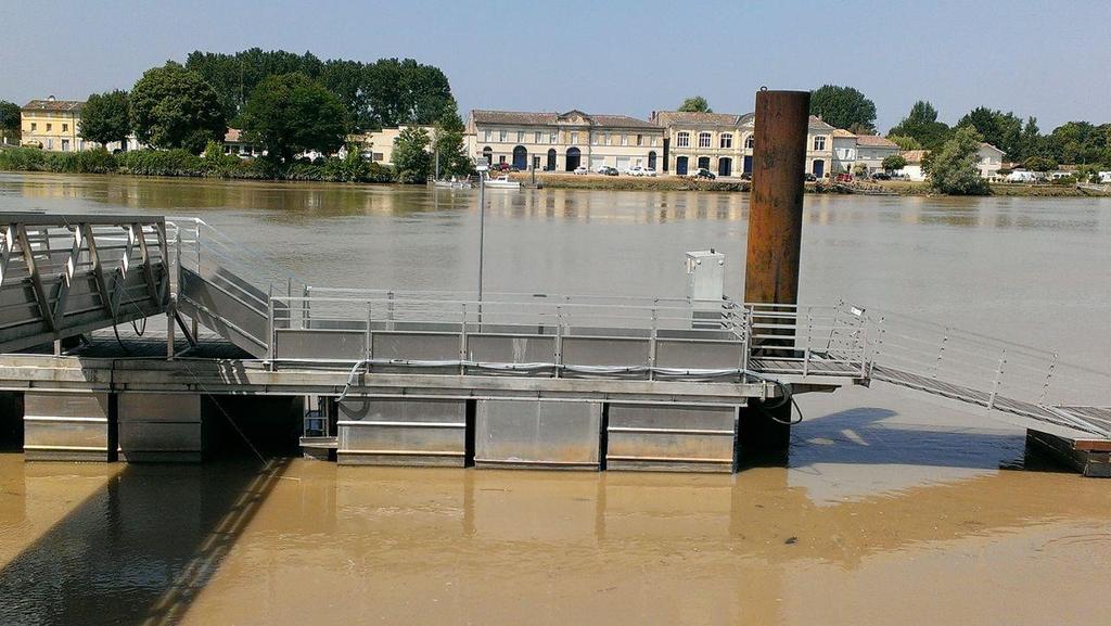
14 The MAGEST network: 4 automated stations that measure each 1 mn: - temperature - salinity - turbidity - dissolved oxygen in surface waters In the central estuary (1) In the fluvial sections (3)

15 The MAGEST network: data transferred each 6 hours to a website of the University of Bordeaux
16 Data at different timescales: semi-diurnal tidal cycles Tidal cycles Etcheber et al (211). Monitoring water quality in estuarine environments. Hydrol. Earth Syst. Sci.
17 Data at different timescales: neap-spring cycles Lanoux et al, (213). Factors contributing to hypoxia in a highly turbid, macrotidal estuary (the Gironde, France). Environ. Sci.: Processes Impacts, 213, 15,
.")
. Environ.")
18 Data at different timescales: neap-spring cycles Lanoux et al, (213). Factors contributing to hypoxia in a highly turbid, macrotidal estuary (the Gironde, France). Environ. Sci.: Processes Impacts, 213, 15,
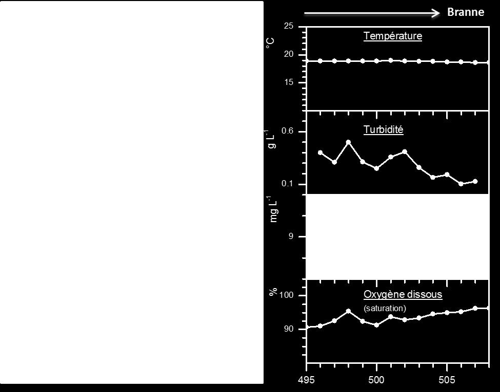
19 Data at different timescales: seasonal changes (daily-mean) m 3 s -1 2 Discharge Garonne Dordogne 1 1/1/213 1/4/213 1/7/213 1/1/213 1/1/ Pauillac Libourne Bordeaux Turbidity NTU /1/213 1/4/213 1/7/213 1/1/213 1/1/214 Schmidt (213). MAGEST newsletter.
 and 21 Pb (T 1/2 = 22.")

20 Radionuclides as tracers of particle dynamics in aquatic system Simplified cycle of 7 Be and 21 Pb 7 Be (53 days) and 21 Pb (T 1/2 = 22.3 years) produced in the atmosphere Adsorption and erosion λ λ λ short half-life strongly bound to particulate matter appropriate tracers to study shortterm particle transport
21 Particulate 7 Be and 21 Pb xs against salinity Monthly survey in All data (surface, bottom waters) 4 7 Be (mbq g -1 ) Pb xs (mbq g -1 ) Salinity PK3 PK5 PK67 PK87
22 Particule transfer along the fluvio-estuarine system of the Gironde 7 Be/ 21 Pb xs 14, 1,5 Low tide surface fluvial estuary Min-Max mean central 7,7 3,5, LR POR LIB PK3 PK11 PK5 PK87 PK Distance from Bordeaux (km)
23 Model to derive age or residence time of particles from 7 Be / 21 Pb xs Activity Ratio (AR) (Matisoff et al, 25) Changes in AR = - Age of suspended particles - Mixing of «young» 7 Be particle with old ( 7 Bedeficient) resuspended particles * * * * * 7 Be/ 21 Pb =14 7 Be/ 21 Pb xs 5 Age (days) % old particles fraction % 7 Be/ 21 Pb particules 7 Be/ 21 Pb reference
24 Particule transfer along the fluvio-estuarine system of the Gironde * * * * * 7 Be/ 21 Pb = 14 5 Low tide surface Min-Max mean 7 Be/ 21 Pb xs Age 4 (days) LR ( ) POR fluvial LIB central estuary PK67 PK5 PK3 PK87 PK11 Particle age days Distance from Bordeaux (km)
25 Occurrence of TMZ upstream and river discharge: 4 m 3 s -1 TMZ River discharge (daily-mean) and turbidity (dayly mean) at Bordeaux for two contrasted hydrological situtations Jan Avril Jan Avril NTU Jan Avril Jan Avril
26 Occurrence of TMZ upstream and river discharge: TMZ NTU Water level (m) River discharge (daily-mean) and turbidity (daily mean) at Bordeaux for two contrasted hydrological situations Record of a large flood in June 2, decembre 1981 m 3 s mars NTU Jan Avril Jan Avril june 5 june Bordeaux Turbidity Raw data 1 Jan Avril Jan Avril 1 june 5 june
27 NTU 1k TMZ Turbidity trend in the Gironde estuary and seasonal change in TMZ position Monthly average turbidity (quartiles) at the four stations of the MAGEST network for the period from January 25 to October 213 the Dordogne Tidal River Libourne 1% 5k 1k Central estuary Pauillac 75% 5% % Jan Apr Jul Oct NTU 5k Jan Apr Jul Oct NTU 1k 5k Bordeaux the Garonne Tidal River NTU 1k 5k Portets Jan Apr Jul Oct Jan Apr Jul Oct 52 km 1 km 12 km distance from the mouth of the Gironde estuary
28 NTU SEDNET November 213, Lisbon Portugal TMZ Occurrence of TMZ upstream and river discharge: Turbidity against discharge for the period from January 25 to October 213 the Dordogne Tidal River 1 Libourne 1 1 Central estuary 1 1 NTU Daily-discharge (m 3 s -1 ) 1 1 the Garonne Tidal River 1 1 NTU 1 NTU 1 Pauillac Daily-discharge (m 3 s -1 ) Flood erosion Bordeaux Portets Daily-discharge (m 3 s -1 ) Daily-discharge (m 3 s -1 ) 52 km 1 km 12 km distance from the mouth of the Gironde estuary
29 NTU SEDNET November 213, Lisbon Portugal TMZ Occurrence of TMZ upstream and river discharge: Turbidity against discharge for the period from January 25 to October 213 the Dordogne Tidal River 1 Libourne 1 NTU 1 1 Central estuary The threshold to move TMZ downstream ranges between 1 and 2 m 3 s Daily-discharge (m 3 s -1 ) 1 1 the Garonne Tidal River 1 1 NTU 1 NTU 1 Pauillac Daily-discharge (m 3 s -1 ) Flood erosion Bordeaux Portets Daily-discharge (m 3 s -1 ) Daily-discharge (m 3 s -1 ) 52 km 1 km 12 km distance from the mouth of the Gironde estuary
30 In conclusion: In the Gironde estuary, continuous monitoring and radionuclides confirm that TMZ and particle residence times are controlled by river discharge. The continuous monitoring had allowed to precise the fluvial discharge levels that control the position of the TMZ. This results demonstrates that in a context of fluvial discharge decrease, the TMZ will stay longer in the fluvial section.
")
31 In conclusion: These results are explained and discussed with local public and private agencies to assist the strategic choices for the management of the estuary (newsletter, annual report, meeting, data transmission..)
 BORDEAUX (mars 25 -) LIBOURNE (nov. 24 -) PORTETS (nov.")
32 Development of the network VERDON (214) Automated stations Specific cruises PAUILLAC (juin 24 --) BORDEAUX (mars 25 -) LIBOURNE (nov. 24 -) PORTETS (nov. 24-janvier 212) CADILLAC (août 213)


33 Thanks for your attention


34

35
36 Evolution de l âge des particules dans la ZTM (PK3) Âge relatif des particules de PK3 surface et fond à marée basse MES 7 Be/ 21 Pb xs * * * * * Référence : particules les plus jeunes à ce site Max 7 Be/ 21 Pb xs 5 5 PK3 Basse mer Surface Fond Débit (m 3 s -1 ) Âge Relatif (jours) J M M J S N J M M J S N J M M J S N J M M J S N
37 Age des particules et cycle marée * * * * * 7 Be/ 21 Pb =14 4 Temps (jours) Surface Fond AR ( 234 Th xs / 21 Pb xs ) Surface Fond 8 7 Be/ 21 Pb xs Âge (jours) 3 6 AR ( 234 Th xs / 21 Pb xs ) 2 4 Mi-Flot Pleine mer Mi-jusant Basse mer 1 2 Site : MES (mg l -1 ) : Salinité (psu) : PK PK PK PK
38 En résumé sur le transfert particulaire le long du continuum fluvio-estuarien de la Gironde, basé sur le bilan des radioéléments Bordeaux Lot Fluvial section Âge des particules : Rétention : Estuaire (ZTM) Âge des particules : Low waters Flood 5-1 j 1-15 j 4-8 j j particules sont 2-4 j évacués Particules remontent dans les rivières
39 En résumé sur le transfert particulaire le long du continuum fluvio-estuarien de la Gironde, basé sur le bilan des radioéléments Figure 8 High river discharge Low marine intrusion.9 GBq d -1 79% Atmospheric fallout.1 GBq d -1 9% River P TMZ oceanic water K d D.13 GBq d -1 12% Low river discharge High marine intrusion Atmospheric fallout.2 GBq d -1 2%.18 GBq d -1 21% River t t t TMZ P D oceanic water.66 GBq d -1 77% Up- Central- Down-estuary
Mapping estuarine turbidity using high and medium resolution time series imagery
 Mapping estuarine turbidity using high and medium resolution time series imagery Virginie Lafon Arthur Robinet Tatiana Donnay David Doxaran Bertrand Lubac Eric Maneux Aldo Sottolichio Olivier Hagolle Alexandra
Nutrient Response to Sewage Abatement in Hong Kong
 Nutrient Response to Sewage Abatement in Hong Kong Prof. Paul J. Harrison Atmospheric, Marine & Coastal Environment Program Institute for the Environment HK University of Science & Technology Outline Background
Hobcaw Barony and the USC Baruch Marine Field Laboratory
 Hobcaw Barony and the USC Baruch Marine Field Laboratory James L. Pinckney Marine Science Program and Department of Biological Sciences School of the Earth, Ocean, and Environment University of South Carolina
Nutrients, Algal Blooms and Red Tides in Hong Kong Waters. Paul J. Harrison and Jie XU
 Nutrients, Algal Blooms and Red Tides in Hong Kong Waters Paul J. Harrison and Jie XU Division of Environment, Hong Kong University of Science & Technology 1. Introduction The Pearl River is China's second
Little Bay Water Quality Report Card Spring 2014
 Little Bay Water Quality Report Card Spring 2014 Little Bay is a small, semi-enclosed estuary located in the heart of Rockport, Texas. Estuaries, where freshwater from rivers and streams mixes with salt
THE RHONE SEDIMENT OBSERVATORY: EVALUATION AND COMMUNICATION ON THE FLUXES OF PARTICULATE CONTAMINANTS AT THE BASIN SCALE
 THE RHONE SEDIMENT OBSERVATORY: EVALUATION AND COMMUNICATION ON THE FLUXES OF PARTICULATE CONTAMINANTS AT THE BASIN SCALE Radakovitch O. 1, Lepage H., Eyrolle F IRSN, PSE/LRTA, Cadarache, France Coquery
Dynamique hydrolog ique, s édimentaire et g éochimique des zones d inondation en Amazonie: résultats et perspectives
 Dynamique hydrolog ique, s édimentaire et g éochimique des zones d inondation en Amazonie: résultats et perspectives 1 Floodplain surface area estimation for the whole Amazon basin: between 3, and 6, km²
EVALUATION OF THE POTENTIAL FOR IMPACTS ON SALMONID MIGRATION ASSOCIATED WITH CIRCULATION OF SALINE POND WATER DURING THE INITIAL STEWARDSHIP PERIOD
 Report 6/9/03 EVALUATION OF THE POTENTIAL FOR IMPACTS ON SALMONID MIGRATION ASSOCIATED WITH CIRCULATION OF SALINE POND WATER DURING THE INITIAL STEWARDSHIP PERIOD 1. OVERVIEW Prepared by Stephen R. Hansen,
SALTWATER INTRUSION IN THE BAIE DE RUPERT, JAMES BAY, CANADA
 IAIA17 Conference Proceedings IA s Contribution in Addressing Climate Change 37 th Annual Conference of the International Association for Impact Assessment 4-7 April 2017 Le Centre Sheraton Montréal Canada
Chesapeake Bay. report card
 Chesapeake Bay report card 2010 C- C Healthy water quality provides better habitat conditions for crabs, fish, and other aquatic species. issolved oxygen is essential to the survival of all these organisms;
Flow-ecology relationships. Flow-ecology relationships Susitna case study
 Flow-ecology relationships Flow-ecology relationships Susitna case study Flow regime Ecologically-Relevant Flow Regime Characteristics Seasonal or typical conditions Annual extreme conditions High and
Real time Water Quality Monitoring
 Real time Water Quality Monitoring Robert Schuster New Jersey Department of Environmental Protection Water Monitoring and Standards Bureau of Marine Water Monitoring Presented at NJWMCC Meeting September
NERRS Science. Collaborative Project
 NERRS Science Collaborative Project Detecting non point nitrogen sources and transport pathways in the Great Bay watershed and engaging decision makers in the science Investigators: Dr. William H. McDowell,
Monitoring water quality in estuarine environments: lessons from the MAGEST monitoring program in the Gironde fluvial-estuarine system
 doi:1.194/hess-1-831-211 Author(s) 211. CC Attribution 3. License. Hydrology and Earth System Sciences Monitoring water quality in estuarine environments: lessons from the MAGEST monitoring program in
ECOLOGICAL DISTURBANCES IN THE ST. LUCIE ESTUARY AND THE SOUTHERN INDIAN RIVER LAGOON, EASTERN FLORIDA, ELUCIDATED THROUGH MACROBENTHIC MONITORING
 ECOLOGICAL DISTURBANCES IN THE ST. LUCIE ESTUARY AND THE SOUTHERN INDIAN RIVER LAGOON, EASTERN FLORIDA, ELUCIDATED THROUGH MACROBENTHIC MONITORING Bjorn Tunberg Scott Jones, Sherry Reed, Michelle Stephens
Causes of Gulf of Mexico Hypoxia
 Causes of Gulf of Mexico Hypoxia Nancy N. Rabalais 1 R. Eugene Turner 2 1 Louisiana Universities Marine Consortium 2 Louisiana State University Center for Sponsored Coastal Ocean Research, Coastal Ocean
Source Water Protection Challenges in the Alafia River Watershed - Tampa, FL
 Source Water Protection Challenges in the Alafia River Watershed - Tampa, FL Doug Robison ESA Bob McConnell Tampa Bay Water AMERICAN WATER RESOURCES ASSOCIATION 2014 Annual Conference November 4, 2014,
Simulation of Circulation and Water Quality in Bellingham Bay
 Simulation of Circulation and Water Quality in Bellingham Bay TARANG KHANGAONKAR & TAIPING WANG Coastal Ocean Modeling Program, Marine Sciences Division State of Bellingham Bay Research Symposium, Western
Intro to sustainable hydropower and environmental flows
 Environmental Flows Workshop Ankara 21 November 2013 Intro to sustainable hydropower and environmental flows Key Issues, intro to methods Dr. Jian-hua Meng, WWF International Environmental Flows Workshop
Climate Change Impacts for the Central Coast and Hunter Regions
 Climate Change Impacts for the Central Coast and Hunter Regions http://www.ozcoasts.gov.au/climate/ima ges/f1_risks.jpg Peter Smith 1 Climate change will have increasing impacts on a wide range of natural
Estuarine, Coastal and Shelf Science
 Estuarine, Coastal and Shelf Science xxx (212) 1e13 Contents lists available at SciVerse ScienceDirect Estuarine, Coastal and Shelf Science journal homepage: www.elsevier.com/locate/ecss Origin and composition
Salinity TMDL Development and Modeling in the Otter Creek Watershed. Erik Makus DEQ Hydrologist June 6, 2013
 Salinity TMDL Development and Modeling in the Otter Creek Watershed 1 Erik Makus DEQ Hydrologist June 6, 2013 Outline for Today: Otter Creek and the Tongue River Previous salinity modeling efforts Existing
The work described in this paper was performed under contract to the Commission of the European Communities.
 A methodology for evaluating the radiological consequences of radioactive effluents released to the aquatic environment in normal operations G. Lawson, C. Attwood, T. Cabianca, J.R. Simmonds National Radiological
Ocklawaha River Restoration as Mitigation
 Ocklawaha River Restoration as Mitigation Dredging Will Further Harm the St. Johns Salinity = Farther Upstream Impacting Wetlands Damaging Submerged Grasses Further Stressing Trees Altering Dissolved Oxygen
Two different Hypoxic Cases: Kangjin Bay, South Sea Chunsu Bay, Yellow Sea, Korea
 Yeosu,Korea May.15-18, 18, 2012 Two different Hypoxic Cases: Kangjin Bay, South Sea Chunsu Bay, Yellow Sea, Korea May 17, 2012 (S7) Young Jae Ro 1, Baek Jin Kim Baek Jin Kim 1 Kwang Young Jung 1 and Kwang
Dog River Watershed Management Plan
 Dog River Watershed Management Plan Preliminary Water Quality Data Analysis Doug Robison, PWS ESA is where solutions and service meet. Water Quality - Regulatory Primer Designated Use Categories Swimming
AP Environmental Science
 AP Environmental Science Types of aquatic life zones MARINE Estuaries coral reefs mangrove swamps neritic zone pelagic zone FRESHWATER lakes and ponds streams and rivers wetlands Distribution of aquatic
LOXAHATCHEE RIVER WATER QUALITY EVENT SAMPLING TASK 2: FINAL REPORT ASSESSMENT OF LOXAHATCHEE RIVER WATER QUALITY
 LOXAHATCHEE RIVER WATER QUALITY EVENT SAMPLING TASK 2: FINAL REPORT ASSESSMENT OF 2007-2008 LOXAHATCHEE RIVER WATER QUALITY In Partial Fulfillment of Agreement No. 4600001281 For the Period October 2007
Oceans OUTLINE. Reading: White, Chapter 15 Today Finish estuaries and particles, then: 1. The oceans: currents, stratification and chemistry
 Oceans OUTLINE Reading: White, Chapter 15 Today Finish estuaries and particles, then: 1. The oceans: currents, stratification and chemistry Next Time Salinity Exercise bring something to calculate with
Water quality monitoring and assessment: general principles and fitness for purpose
 Water quality monitoring and assessment: general principles and fitness for purpose Deborah V Chapman GEMS/Water Capacity development Centre University College Cork Considerations Purpose of monitoring
Commonwealth Champions VA TeCH
 Commonwealth Champions VA TeCH Assessing Coastal Habitat Vulnerability to Local Climate Stressors within the York River Estuary CCVATCH-CBNERR Workshop December 5, 2013 Gloucester Point, Virginia Chesapeake
FILLING THE GAP: DISSOLVED OXYGEN MONITORING IN NARRAGANSETT BAY
 FILLING THE GAP: DISSOLVED OXYGEN MONITORING IN NARRAGANSETT BAY Christopher F. Deacutis, Narragansett Bay Estuary Program, URI Coastal Institute Keywords: Narragansett Bay, intermittent hypoxia, volunteer
EVALUATION ON THE IMPACTS OF UPSTREAM DAM DEVELOPMENT ON SALINITY INTRUSION INTO VIETNAMESE MEKONG DELTA
 UNESCO-JASTIP Joint Symposium on Intra-Regional Water Security and Disaster Management EVALUATION ON THE IMPACTS OF UPSTREAM DAM DEVELOPMENT ON SALINITY INTRUSION INTO VIETNAMESE MEKONG DELTA TRUNG LA
Osher Course. What Lies Beneath the Inland Bays?
 Osher Course What Lies Beneath the Inland Bays? Objectives for Course Describe the Delaware Inland Bays and their tributaries Illustrate the ecology and importance of estuaries Demonstrate the threats
Sources and transport of mercury and methylmercury in rivers and streams of the Upper Mississippi River watershed
 NIMD Forum 21 February 4-5, 21 Sources and transport of mercury and methylmercury in rivers and streams of the Upper Mississippi River watershed Steven J. Balogh Metropolitan Council Environmental Services
Salt Dispersion in Delaware Bay
 Salt Dispersion in Delaware Bay Maria Aristizabal Robert Chant This work has been supported by NSF, Rutgers University and a Dupont fellowship. Delaware Estuary Science and environmental summit Jan 27-30
Science of the Causes of Hypoxia Nancy Rabalais et al.
 Science of the Causes of Hypoxia Nancy Rabalais et al. In support of overview of diversions and hypoxia, and context for refining science needs; July 14, 2014 Scientific Curiosity Hypothesis Testing Management
The Dissolved Oxygen Status of the Inland Bays : First Draft. Chris Bason Delaware Center for the Inland Bays CIB STAC July 16, 2010
 The Dissolved Oxygen Status of the Inland Bays 1998 2009: First Draft Chris Bason Delaware Center for the Inland Bays CIB STAC July 16, 2010 Importance A primary impairment under the Clean Water Act --
GRAYS HARBOR ESTUARY MANAGEMENT UNIT GRAYS HARBOR ESTUARY
 GRAYS HARBOR ESTUARY MANAGEMENT UNIT GRAYS HARBOR ESTUARY Description: The Grays Harbor Estuary is a bar-built estuary that was formed by the combined processes of sedimentation and erosion caused by both
How global warming and climate change may be accelerating losses of Chesapeake Bay seagrasses.
 How global warming and climate change may be accelerating losses of Chesapeake Bay seagrasses. Dr. Ken Moore The Virginia Institute of Marine Science School of Marine Science College of William and Mary
Organically bound tritium in freshwater ecosystems : long term trends in the environment of french nuclear power stations
 Organically bound tritium in freshwater ecosystems : long term trends in the environment of french nuclear power stations Françoise Siclet EDF R&D National hydraulics and environment laboratory Radioecological
What Characterizes the Taninim Estuary in Relation to Other Mediterranean Microestuaries in Israel and Implications for the River rehabilitation
 What Characterizes the Taninim Estuary in Relation to Other Mediterranean Microestuaries in Israel and Implications for the River rehabilitation Sarig Gafny (sarig@ruppin.ac.il) The RIME team: Gitai Yahel,
Management Modeling of Suspended Solids and Living Resource Interactions
 Management Modeling of Suspended Solids and Living Resource Interactions Carl Cerco 1, Mark Noel 1, Sung-Chan Kim 2 1 Environmental Laboratory, US Army ERDC, Vicksburg MS, USA 2 Coastal and Hydraulics
Environmental Flows for the Galveston Bay Estuary. Scott A. Jones Environmental Policy & Outreach Galveston Bay Foundation
 Environmental Flows for the Galveston Bay Estuary Scott A. Jones Environmental Policy & Outreach Galveston Bay Foundation Galveston Bay Foundation Mission: To preserve, protect, and enhance the natural
Dead-Zones and Coastal Eutrophication: Case- Study of Chesapeake Bay W. M. Kemp University of Maryland CES Horn Point Laboratory Cambridge, MD
 Dead-Zones and Coastal Eutrophication: Case- Study of Chesapeake Bay W. M. Kemp University of Maryland CES Horn Point Laboratory Cambridge, MD Presentation to COSEE Trends Orientation at UMCES HPL 4 August
Thresholds in Recovery of Eutrophic Bay Sub-Systems: Five Case-Studies
 Thresholds in Recovery of Eutrophic Bay Sub-Systems: Five Case-Studies W. Michael Kemp, Walter Boynton, and Denise Breitburg University of Maryland CES & SERC (Collaborators: J. Testa, Y. Lee, J. Hagy,
Lower Columbia River Pile Dike Assessment
 Lower Columbia River Pile Dike Assessment David Gorman, PE August 2, 2011 Credits Hans R. Moritz, US Army Corps of Engineers Portland District Carl Kassebaum, AECOM Project Manager AECOM Coastal and Rivers
Physical processes and hydrodynamic modeling in lakes and reservoirs
 Physical processes and hydrodynamic modeling in lakes and reservoirs Thesis: Comparison of the 3D hydrodynamic models and predicting the response of reservoirs to climate change effects Behnam Zamani *
Research, Monitoring and Environmental Protections on the Shubenacadie River Estuary. June 2017 (updated September 2017)
") Research, Monitoring and Environmental Protections on the Shubenacadie River Estuary June 2017 (updated September 2017) 1 Overview 1. What is the Alton Natural Gas Project? 2. Summary of River Research
Research, Monitoring and Environmental Protections on the Shubenacadie River Estuary June 2017 (updated September 2017) 1 Overview 1. What is the Alton Natural Gas Project? 2. Summary of River Research
fcgov.com/water-quality Water Quality Update Fall 2017 Monitoring and Protecting Our Water Sources
 Water Quality Update Fall 217 Monitoring and Protecting Our Water Sources SOURCE WATER MONITORING The Upper Cache la Poudre (UCLP) Watershed Collaborative Monitoring Program was established in 28 between
Southern California Bight 2008 Regional Monitoring Program: Volume VIII. Estuarine Eutrophication
 Technical Report 0711 Southern California Bight 2008 Regional Monitoring Program: Volume VIII. Estuarine Eutrophication K. McLaughlin 1, M. Sutula 1, L. Busse 2, S. Anderson 3, J. Crooks 4, R. Dagit 5,
Otter Creek Watershed TMDL Project. Stakeholder Meeting June 6, 2013
 Otter Creek Watershed TMDL Project Stakeholder Meeting June 6, 2013 1 Meeting Purpose Meet with watershed & technical advisory group members and watershed landowners to provide basic Otter Creek TMDL project
Climate Change & the Tongass NF: Potential Impacts on Freshwater Ecosystems. Gordon H. Reeves US Forest Service PNW Research Station
 Climate Change & the Tongass NF: Potential Impacts on Freshwater Ecosystems Gordon H. Reeves US Forest Service PNW Research Station Inches Changes in Precipitation 5 0 From: http://igloo.atmos.uiuc.edu/snap/
A Method For Managing Freshwater Inflows To Estuaries
 A Method For Managing Freshwater Inflows To Estuaries Stephen B. Olsen Coastal Resources Center University of Rhode Island Woodrow Wilson Center Washington D.C. December 7, 2006 The Integrated Management
Onsite Septic System Nitrogen Contributions to the Hood Canal Estuary. Department of Civil and Environmental Engineering, University of Washington
 Onsite Septic System Nitrogen Contributions to the Hood Canal Estuary Michael Brett, Peter Steinberg, Julie Horowitz, Bryan Atieh, Garrett Leque, and Mark Benjamin Department of Civil and Environmental
Chapter 11: Recommendations. Chapter 11 DIADROMOUS FISH HABITAT CONSERVATION AND RESTORATION RECOMMENDATIONS AND/OR REQUIREMENTS
 Chapter 11: Recommendations Chapter 11 DIADROMOUS FISH HABITAT CONSERVATION AND RESTORATION RECOMMENDATIONS AND/OR REQUIREMENTS 445 Atlantic Coast Diadromous Fish Habitat Group I. Recommendations for All
Numerical Simulation of the Salty Water Intrusion After the Construction of Houshan Reservoir, China
 Advanced Materials Research Submitted: 2014-06-11 ISSN: 1662-8985, Vols. 1010-1012, pp 1070-1074 Accepted: 2014-06-15 doi:10.4028/www.scientific.net/amr.1010-1012.1070 Online: 2014-08-13 2014 Trans Tech
Effect of climate change on low-flow conditions in Ruscom River watershed, Ontario
 Effect of climate change on low-flow conditions in Ruscom River watershed, Ontario by Tirupati Bolisetti Co-Authors: M. Rahman and R. Balachandar August 5, 2009 Introduction Climate change refers to the
Contentious Wetlands and Connections to Streams: Using Science to inform Policy and Practice
 Contentious Wetlands and Connections to Streams: Using Science to inform Policy and Practice Riparia - a Center where science informs policy and practice in wetlands ecology, landscape hydrology, and watershed
Distinguishing human and climate influences on the Columbia River: changes in the disturbance processes
 Cold Region Hydrology in a Changing Climate (Proceedings of symposium H02 held during IUGG2011 in Melbourne, Australia, July 2011) (IAHS Publ. 346, 2011). 21 Distinguishing human and climate influences
Nitrogen Cycling, Primary Production, and Water Quality in the New River Estuary. Defense Coastal/Estuarine Research Program (DCERP)
") Nitrogen Cycling, Primary Production, and Water Quality in the New River Estuary Defense Coastal/Estuarine Research Program (DCERP) Introduction: A key theme of the ongoing DCERP program is monitoring
Nitrogen Cycling, Primary Production, and Water Quality in the New River Estuary Defense Coastal/Estuarine Research Program (DCERP) Introduction: A key theme of the ongoing DCERP program is monitoring
PRESS RELEASE. LOUISIANA UNIVERSITIES MARINE CONSORTIUM August 2, 2017 SUMMARY
 PRESS RELEASE LOUISIANA UNIVERSITIES MARINE CONSORTIUM August 2, 2017 SUMMARY The 2017 area of low oxygen, commonly known as the Dead Zone, measured 22,720 square kilometers (= 8,776 square miles) is the
Water Resources on PEI: an overview and brief discussion of challenges
 Water Resources on PEI: an overview and brief discussion of challenges Components: Components and links Atmospheric water Surface water (including glacial water) Groundwater Links: Precipitation (atm(
Yes: Y No: N (a) (b) (c) (d) (a) (a) (b) (c) (d) (e)
 (b) (c) (d) (a) (a) (b) (c) (d) (e)") Checklist: 3. Hydropower Stations, Dams and Reservoirs (1) 1 Permits and Explanation 2 Pollution Control (1) EIA and Permits (2) Explanation to the Local Stakeholders Main Check s Have EIA reports been
Checklist: 3. Hydropower Stations, Dams and Reservoirs (1) 1 Permits and Explanation 2 Pollution Control (1) EIA and Permits (2) Explanation to the Local Stakeholders Main Check s Have EIA reports been
2013 International SWAT Conference, Toulouse, France. Université de Toulouse ; INPT, UPS ; EcoLab, ENSAT, Castanet Tolosan, France 2
 Implementation of a new module to simulate trace metals transport in large rivers by coupling SWAT and MOHID models: The case of the Garonne River (France) Garneau C. 1, Sauvage S. 1,2, Probst A. 1,2,
Mapping water constituents concentrations in estuaries using MERIS full resolution satellite data
 Mapping water constituents concentrations in estuaries using MERIS full resolution satellite data David Doxaran, Marcel Babin Laboratoire d Océanographie de Villefranche UMR 7093 CNRS - FRANCE In collaboration
Understanding Measures of Water Quality: Choosing the Appropriate Method for Permit Compliance
 Understanding Measures of Water Quality: Choosing the Appropriate Method for Permit Compliance Shelly Anghera, Ph.D., Steve Cappellino and Andrew Martin September 7, 2012 WEDA Pacific Why does WEDA membership
ASSESSMENT OF SALINITY INTRUSION IN THE RED RIVER UNDER THE EFFECT OF CLIMATE CHANGE
 ASSESSMENT OF SALINITY INTRUSION IN THE RED RIVER UNDER THE EFFECT OF CLIMATE CHANGE Presented by NGUYEN Trung Viet Water Resources University, Vietnam March 2-4, 2011 Introduction Red River System is
PRESS RELEASE. LOUISIANA UNIVERSITIES MARINE CONSORTIUM July 28, Abstract
 PRESS RELEASE LOUISIANA UNIVERSITIES MARINE CONSORTIUM July 28, 2013 Abstract The 2013 area of low oxygen, commonly known as the Dead Zone, measured 15,120 square kilometers (= 5,800 square miles) in this
The Importance of the Pearl River to Mississippi s Estuarine Habitats Jennifer Buchanan Education Coordinator
 The Importance of the Pearl River to Mississippi s Estuarine Habitats Jennifer Buchanan Education Coordinator 2006 Pearl River Basin Symposium May 5-6, 2006 Topics for Discussion What s an estuary? Pearl
2016, 2017 Estuarine Water Quality and Modeling in the Royal and Cousins Rivers
 2016, 2017 Estuarine Water Quality and Modeling in the Royal and Cousins Rivers Angela Brewer and Robert Mohlar Division of Environmental Assessment Bureau of Water Quality Protecting Maine s Air, Land
Planning for Dredging and the Environment on the Tidal Thames
 Planning for Dredging and the Environment on the Tidal Thames 1 INTRODUCTION This Information Note forms the final document in a set of three notes designed to inform berth operators and environmental
Water Quality Assessment in the Thames River Watershed
 Water Quality Assessment in the Thames River Watershed Nutrient Trends Karen Maaskant, Upper Thames River Conservation Authority 2015 Lake St. Clair Conference October 21, 2015 Outline Thames River watershed,
Climate Change Impacts on Water in NW Washington
 Climate Change Impacts on Water in NW Washington Roger Fuller Western Washington University www.skagitclimatescience.org Climate Change: Quick refresher on the mechanism Greenhouse gases in the atmosphere
Restoring Rivers Through Dam Removal
 Restoring Rivers Through Dam Removal Thomas Ardito Narragansett Bay Estuary Program Chris Fox Wood-Pawcatuck Watershed Association Who We Are: Narragansett Bay Estuary Program Mission: To protect and restore
Appendix I: Fixed-400,000 af Flood Storage Operation
 Appendix I: Fixed-400,000 af Flood Storage Operation 1.0 FIXED-400,000 AF FLOOD STORAGE OPERATION This operation set provides a comparison of operations before the SAFCA/Reclamation interim agreement in
Behaviour of 238 U family radionuclides in continental environment: Case of the U mining area near Limoges (France)
") dioprotection, Suppl., vol. 40 (2005) S323-S328 EDP Sciences, 2005 DOI:.5/radiopro:2005s-048 Behaviour of 238 family radionuclides in continental environment: Case of the mining area near Limoges (France)
dioprotection, Suppl., vol. 40 (2005) S323-S328 EDP Sciences, 2005 DOI:.5/radiopro:2005s-048 Behaviour of 238 family radionuclides in continental environment: Case of the mining area near Limoges (France)
Nutrient distributions and the interaction between coastal wetlands and the nearshore of Lake Ontario
 Nutrient distributions and the interaction between coastal wetlands and the nearshore of Ontario Krista Chomicki and Gary Bowen International Association of Great s Research, 25 Type Durham Region Coastal
1 INTRODUCTION 2 MOTIVATION FOR THE PRESENT EXPERIMENT. Dynamics of the Salt-Freshwater Mixing Zone in Ocean Beaches. N. Cartwright 1 and P.
 Second International Conference on Saltwater Intrusion and Coastal Aquifers Monitoring, Modeling, and Management. Mérida, Mexico, March 3 April, 3 Dynamics of the Salt-Freshwater Mixing Zone in Ocean Beaches
Does Water Resources Management in the Snake River Basin Matter for the Lower Columbia River? Or Is the Snake River Part of Another Watershed?
 Does Water Resources Management in the Snake River Basin Matter for the Lower Columbia River? Or Is the Snake River Part of Another Watershed? John C. Tracy, Director Idaho Water Resources Research Institute
Effects of Winds on Hypoxia Formation in the Pearl River Estuarine Coastal Waters
 The 1th International Estuarine Biogeochemistry Symposium May 19-22, 28, Xiamen China Effects of Winds on Hypoxia Formation in the Pearl River Estuarine Coastal Waters Kedong YIN 1,2,3, Paul J. Harrison
Concurrent Session 129 The hydroecology of a Florida river and the potential ecological effects of human water use (Part 2 of 2)
") Concurrent Session 129 The hydroecology of a Florida river and the potential ecological effects of human water use (Part 2 of 2) Photograph: Dean Campbell Moderator: Ed Lowe, Ph. D. Director, Bureau of
Concurrent Session 129 The hydroecology of a Florida river and the potential ecological effects of human water use (Part 2 of 2) Photograph: Dean Campbell Moderator: Ed Lowe, Ph. D. Director, Bureau of
DRINKING WATER QUALITY FORECASTING SALINITY INTRUSION IN WHAKATANE RIVER
 DRINKING WATER QUALITY FORECASTING SALINITY INTRUSION IN WHAKATANE RIVER Ben Tuckey 1, Colin Roberts 1 and Santhan Gunasantha 2. 1 DHI New Zealand, ecentre, Oaklands Road, Auckland. 2 Whakatane District
Xayaburi Hydroelectric Power Project
 The MRC Regional Workshop on Discharge and Sediment Monitoring and Geomorphological Tool for the Lower- Mekong Basin, 21-22 22 October 2008 Xayaburi Hydroelectric Power Project TEAM Consulting Engineering
Results from the 2017 Water Quality Monitoring Program
 Results from the 217 Water Quality Monitoring Program As part of a larger project, this summer the BWC conducted water sampling throughout the Belleisle Bay to get a baseline of data and determine the
SOURCE WATER MONITORING
 Monitoring and Protecting Our Water Sources SOURCE WATER MONITORING The Upper Cache la Poudre (UCLP) Watershed Collaborative Monitoring Program was established in 28 between the City of Fort Collins, the
Response of Juvenile Salmonids to Habitat Restoration in Humboldt Bay, CA. Michael Wallace California Department of Fish and Game
 Response of Juvenile Salmonids to Habitat Restoration in Humboldt Bay, CA Michael Wallace California Department of Fish and Game What did the fish tell us about habitat needs and use? Coho Salmon Catches
European Sediments 1
 European Sediments 1 SEDNET Network Editors: Wim Salomons, Ulrich Förstner, Jos Brils Contact: Jos Brils (SEDNET coordinator): Brils@mep.tno.nl Contents 1. Introduction: Scope...1 2. European policies
Nicholas A. Reckinger. June 11, 2007
 Comparison of Phosphorus Forms at Different Spatial Scales and Assessment of an Area-Weighted P-Index to Multi-Field Watersheds Nicholas A. Reckinger June 11, 2007 Watershed Activities Affect Water Quality
Water Quality Study In the Streams of Flint Creek and Flint River Watersheds For TMDL Development
 Water Quality Study In the Streams of Flint Creek and Flint River Watersheds For TMDL Development Idris Abdi Doctoral Dissertation Presentation Major Advisor: Dr. Teferi Tsegaye April 18, 2005 Alabama
Lake of the Woods TMDL: Update and Next Steps November 21, 2017
 Lake of the Woods TMDL: Update and Next Steps November 21, 2017 Outline Where we ve been (2016) HSPF Bathtub Internal loading estimation Progress in 2017 Development of TMDL load allocation table Next
7.9 Nitrogenous Nutrients and Plankton Production in Jamaica Bay, NY
 7.9 Nitrogenous Nutrients and Plankton Production in Jamaica Bay, NY Ray Sambrotto 7.9.1 SUMMARY Two blooms characterize phytoplankton growth in Jamaica Bay: the winter/spring bloom, between February and
Coastal environments including estuaries fluxes CH 4.
 Methane is an atmospheric trace gas that contributes significantly to the greenhouse effect. Biogenic methane is produced exclusively by a group of strict anaerobes (methanogens) during methanogenesis.
Estuarine and Coastal Biogeochemistry
 Estuarine and Coastal Biogeochemistry OCN 623 Chemical Oceanography 9 April 2013 Reading: Seitzinger & Mayorga (2008) 2013 Frank Sansone 1. Global coastal zone Outline 2. Nutrient loading in estuaries
GEOCHEMICAL BEHAVIOR OF DISSOLVED IRON IN WATERS FROM
 GEOCHEMICAL BEHAVIOR OF DISSOLVED IRON IN WATERS FROM THE AMUR RIVER, AMUR-LIMAN AND SAKHALIN BAY NAGAO S. 1, TERASHIMA M., TAKATA H. 1, SEKI O. 1, KIM V. I. 3, SHESTERKIN V. P. 3, LEVSHINA I. S. 3 AND
APPENDIX A. 2-Gates Fish Protection Demonstration Project Background and Regulatory Constraints
 APPENDIX A 2-Gates Fish Protection Demonstration Project Background and Regulatory Constraints Project Background The Delta serves many functions and has many competing uses. It is a vital diversion point
Gilleland Creek Intensive Bacteria Survey Addendum. March 18, 2010
 Gilleland Creek Intensive Bacteria Survey Addendum March 18, 21 Prepared by: Texas Stream Team Texas State University San Marcos PREPARED IN COOPERATION WITH THE TEXAS COMMISSION ON ENVIRONMENTAL QUALITY
Alosa alosa - Conservation and restoration of the Allis shad in the Gironde and Rhine watersheds LIFE09 NAT/DE/000008
 Alosa alosa - Conservation and restoration of the Allis shad in the Gironde and Rhine watersheds LIFE09 NAT/DE/000008 Project description Environmental issues Beneficiaries Administrative data Read more
Vincent Rebour, Frédéric Ménage IRSN: PRP-DGE/SCAN, PSN-EXP. Assessing flooding hazards: new guidelines
 Vincent Rebour, Frédéric Ménage IRSN: PRP-DGE/SCAN, PSN-EXP Assessing flooding hazards: new guidelines 1 Content 1. Experience feedback from Le Blayais 2. New guidelines for NPPs and other NIs 3. Conclusion
Fig. 1. Map for location
 The Asian Journal of Biology Education (2002) Number 1 3 Faculty of Education, Shiga University 2--1 Hiratsu, Otsu, 20-0862. Japan. Introduction Lake Biwa (Fig. 1) is the largest lake in Japan and one