GEOTECHNICAL EVALUATION OF CALIFORNIA S CENTRAL VALLEY LEVEES
|
|
|
- Charles Moody
- 6 years ago
- Views:
Transcription
1 GEOTECHNICAL EVALUATION OF CALIFORNIA S CENTRAL VALLEY LEVEES Steven Mahnke, PE, GE California Department of Water Resources Sujan Punyamurthula, PhD, PE URS Corporation Mark W. Connelly, PMP Kleinfelder Floodplain Management Association September 3,
2 AGENDA Levee Evaluation Program Overview Current applications of data and tools Going forward future uses 2
3 Local Agencies What s In It for You Get a jump start on your projects Understanding the guidelines, criteria and procedures for guidance documents, criteria, remedial alternatives, and preliminary costs Supporting documentation for financing plans and grant applications State Updated Levee Evaluations for Basin Wide Feasibility Studies and 2017 CVFPP Early input for Regional Flood Management Planning Yolo Bypass/Cache Slough IWMP Federal Reference information for USACE Planning Studies/Civil Works Projects Continued support in addressing flood risks in SJRRP implementation Coming Soon: Web-based access to the entire body of knowledge 3

4 Goals evaluation of SPFC/appurtenant non-project levees Preliminary levee repair remedies and costs Consideration for urban and non-urban area protection Support CVFPP Footprint Levee Evaluation Program Urban levee miles Non-Urban - 1,650 levee miles Overview 4
 Phase 1 Field Exploration and Laboratory")


 Final")
5 ULE Phased Implementation STEP 1 Historical Data Collection STEP 2 Initial Field Investigation STEP 3 Preliminary Analysis Data Review Data Technical Review Memorandum (TRM) Phase 1 Field Exploration and Laboratory Testing Data Technical Review Memorandum (TRM) Perform Phase 1 Analyses Phase 1 Evaluation Report (P1GER) STEP Supplemental Final Historical Initial Preliminary Analyses Field Data Field Analysis and Collection Investigation Report Supplemental Phase Data Final 1 Supplemental Phase 1 Perform Technical Field Exploration Data Supplemental Phase 1 Evaluation Review Data and Review Laboratory Analyses Memorandum Report Testing (P1GER) (SGDR) (TRM) (GER) STEP 4 Supplemental Field Investigation Supplemental Field Exploration and Laboratory Testing STEP 5 Final Analyses and Report Perform Supplemental Analyses Supplemental Data Report (SGDR) Final Evaluation Report (GER) 5

 Remedial Alternatives & Cost Estimating Report (RACER) Data Report (GDR)")
6 NULE Phased Implementation Phase 1 (For All NULE Areas) Phase 2 (Selected Areas) Data Collection & Geomorphic Studies Assessment Remediation Alternatives & Cost Estimates Field & Laboratory Investigations Analysis & Cost Estimates Updates Geomorphic Studies Maps & Project Database Assessment Report (GAR) Remedial Alternatives & Cost Estimating Report (RACER) Data Report (GDR) Overview Report (GOR) 6
 >10,000 Docs")
 Bathymetry")
 Over-water")
 Geomorphic")


7 TYPE Data Collected Data Collected Historical Data Historical levee documents (>8,000) >10,000 Docs Agency research/interviews (>2,000) Topography Aerial LiDAR survey with video (510 miles) Bathymetry Geophysics Geomorphology Environmental Subsurface Investigations Land surveys (100,000 ft) Over-water channel topography (>100 miles) Aerial HEM (455 miles) Land-based galvanic resistivity (>100 mi) Geomorphic studies and map compilation Biological surveys Cultural surveys Cone Penetrometer Tests Rotary borings >5300 Sonic borings Other Test pits/hand augers Piezometers with instrumentation Laboratory testing (> 15,000) Vegetation Burrowing mammals 7


8 Tools and Analytical Products Data Collection/ Data Management Environmental Permitting & Cultural Resources Analyses Levee Performance Assessment Tools Remedial Alternatives & Cost Estimating Tool Document Database, POI Map Field Data Collection Tool Mapping Protocols Guidance Document > 1500 sections > 10,000 Analyses Levee Assessment Tool Performance/Fragility Curves Erosion Toolbox Seismic/Liquefaction Analyses Tools Suite of Well developed Remedial Alternatives Cost Estimating Tool for Levees 8
9 SAMPLE OF CURRENT APPLICATIONS Local Agencies State Federal SAFCA Natomas, Sacramento River projects, NEMDC and Arcade Creek Central Valley Flood Protection Plan (CVFPP) Feasibility Studies (Sutter, SJFCA, West Sacramento, Woodland) SBFCA : Feather River West Levee Improvement Project Central Valley Floodplain Evaluation and Delineation (CVFED) Levee Periodic Inspections West Sacramento Levee Improvement Program (WSAFCA) RD17 Levee Strengthening (SJFCA) Urban Levee Design Criteria (ULDC) Regional Flood Management Planning Levee Screening Assessment (LSAC) Ongoing Design Projects (Marysville, West Sacramento, Natomas) 9
10 Support to Other DWR Programs DWR Program Supported Activity Use of Levee Evaluation Data/Products NULE's Points of Interest (POI) data formed basis for identification of potential repair sites. Flood Maintenance Flood Projects San Joaquin River Restoration Program Other FloodSAFE Flood System Repair Project (FSRP) Rural Levee Repair Guidelines Emergency Levee Repairs San Joaquin Levee Evaluation Program (SJLE) Special Studies POI reconnaissance, assisted development of evaluation protocols and ranking of potential repair projects. NULE repair templates and parametric cost estimating tools used to prepare Pre-Feasibility Cost Estimates for eligible FSRP projects. Provided geotechnical support in developing uniform guidelines to assist State and local agencies Alternatives Design Report for emergency levee repairs for Chowchilla Bypass and Lower San Joaquin Levee District data report in support of levee repairs at Mormon Slough Developed flood risk criteria for SJRRP and prioritized levees for geotechnical evaluation. Coordinated levee crest road repairs during 2011 high water event to support increased restoration flows evaluation of 40 miles of levees for increased restoration flows using ULE/NULE evaluation protocols Levee Sesimic Vulnerability Assessment Assessment of Animal Burrow Persistence Influence of Levee Vegetation on Past Performance Vegetation Studies to support CVFPP Levee Vegetation Management Strategy 10
11 Local Agencies What s In It for You Get a jump start on your projects Understanding the guidelines, criteria and procedures for guidance documents, criteria, remedial alternatives, and preliminary costs Supporting documentation for financing plans and grant applications State Updated Levee Evaluations for Basin Wide Feasibility Studies and 2017 CVFPP Early input for Regional Flood Management Planning Yolo Bypass/Cache Slough IWMP Federal Reference information for USACE Planning Studies/Civil Works Projects Continued support in addressing flood risks in SJRRP implementation Coming Soon: Web-based access to the entire body of knowledge 11
12 QUESTIONS? GEOTECHNICAL EVALUATION OF CALIFORNIA S CENTRAL VALLEY LEVEES Steven Mahnke, PE GE California Department of Water Resources Sujan Punyamurthula, PhD, PE URS Corporation Mark W. Connelly, PMP Kleinfelder, Inc. Floodplain Management Association September 3,
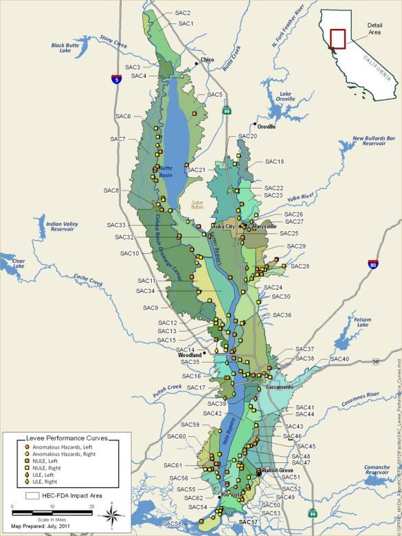


13 CVFPP - Performance Curves 13

14 SJLE Levee Evaluation Program Support to Date Levee crest/access road repairs 18 miles SJLE explorations EB CPTs, 19 borings SJLE explorations 4A 21 CPTs, 5 borings SJLE analyses Seepage/Stability analyses to support increased SJRRP restoration flows NULE explorations 3/4A 114 CPTs, 22 borings Reach 2A SJLE - 18 CPTs, 8 borings NULE 50 CPTs, 18 borings 14

15 FSRP Repair Site Selection and Costing Sacramento Valley 106 Critical sites identified, evaluated, and vetted with local agencies Pre-feasibility cost estimate reports for each leveed area to support grant process San Joaquin Valley 15
Marysville Levee Commission
 Marysville Levee Commission Outline CVFPP Goals & Objectives Highlights of Draft Feather River RFMP Integration between Flood Protection, Agriculture and Wildlife and Floodplain Uses Proposed Projects
June 22, Francis E. Borcalli, P.E.
 CACHE CREEK SETTLING BASIN SYMPOSIUM Managing the Settling Basin Who s Doing What! June 22, 2009 Francis E. Borcalli, P.E. CACHE CREEK SETTLING BASIN SYMPOSIUM Managing the Settling Basin Who s Doing What!
9. Levee Maintaining Agency Projects
 9. Levee Maintaining Agency Projects 9.1. Overview This chapter summarizes the known deficiencies identified for each local levee maintaining agency (LMA) within the Regions. Note that although the focus
Lower San Joaquin River Feasibility Study PLAN FORMULATION ADDENDUM
 PLAN FORMULATION ADDENDUM Non-Structural Measure Descriptions Elevate Critical Infrastructure This measure would raise at-risk critical structures above the design inundation level. Elevation would be
2017 Central Valley Flood Protection Plan Update: Overview
 2017 Central Valley Flood Protection Plan Update: Overview 2015 FMA Conference CVFPP Overview- Mike Mierzwa, DWR Basin-wide Feasibility Study Planning Context- Eric Tsai, DWR Technical Tools/Methodologies-
Appendix VI: Illustrative example
 Central Valley Hydrology Study (CVHS) Appendix VI: Illustrative example November 5, 2009 US Army Corps of Engineers, Sacramento District Prepared by: David Ford Consulting Engineers, Inc. Table of contents
PAGE LEFT INTENTIONALLY BLANK
 PAGE LEFT INTENTIONALLY BLANK EXECUTIVE SUMMARY This Post Authorization Change Report (PACR) for the Sacramento River Bank Protection Project (SRBPP) identifies the Federal interest in the SRBPP as modified
CITY OF MOUNTAIN VIEW
 CITY OF MOUNTAIN VIEW Incorporate Climate Change Adaptation in Municipal Scale, Urban Watershed Planning at the City of Mountain View Raymond Wong, PhD, PE, LEED AP Lisa Au, PE Floodplain Management Association
Proposal and Statement of Qualifications for Sacramento County Delta Legacy Communities Flood Risk Reduction Feasibility Studies
 Proposal and Statement of Qualifications for Sacramento County Delta Legacy Communities Flood Risk Reduction Feasibility Studies SACRAMENTO COUNTY DEPARTMENT OF WATER RESOURCES Submitted by GEI Consultants,
The origin and evolution of the california state plan of flood control levee system
 July 3 7, The origin and evolution of the california state plan of flood control levee system Graham Bradner a, Emilie Singleton b Engineering Division, GEI Consultants, Sacramento, United States a gbradner@geiconsultants.com
Central Valley hydrology study
 Central Valley hydrology study November 29, 2015 Prepared for California Department of Water Resources Letter of agreement #4600007762 Prepared by US Army Corps of Engineers Sacramento District and David
10.0 References. California Department of Water Resources Feasibility Report, American Basin Conjunctive Use Project. Sacramento, CA.
 10.0 References American States Water Company, Wood Rodgers, Inc., Stratecon, Inc., and Hatch & Parent. 2006. Integrated Water Resources Management Plan. Prepared for Natomas Central Mutual Water Company.
APPENDIX A. Project Scoping
 APPENDIX A Project Scoping Notice of Preparation To: From: Agencies and Interested Parties Paul Brunner, Executive Director, Three Rivers Levee Improvement Authority Date: June 13, 2006 Subject: Notice
LOWER CACHE CREEK, YOLO COUNTY WOODLAND AREA FEASIBILITY STUDY
 Background LOWER CACHE CREEK, YOLO COUNTY WOODLAND AREA FEASIBILITY STUDY Energy and Water Development Appropriations Act of 1993 Reconnaissance Study completed June 1994 Feasibility Cost Share Agreement
DRAFT Sacramento s Comprehensive Flood Risk Reduction Program
 DRAFT Sacramento s Comprehensive Flood Risk Reduction Program March 20, 2017 1007 7 th St, 7 th Floor Sacramento, CA 95814 Table of Contents 1. Introduction... 2 2. Flood System Management... 6 American
Estimation of rearing habitat requirements of San Joaquin River Chinook salmon using the Emigrating Salmonid Habitat Estimation (ESHE) Model
 Model") Estimation of rearing habitat requirements of San Joaquin River Chinook salmon using the Emigrating Salmonid Habitat Estimation (ESHE) Model California Central Valley Cramer Fish Sciences *Draft conceptual
Estimation of rearing habitat requirements of San Joaquin River Chinook salmon using the Emigrating Salmonid Habitat Estimation (ESHE) Model California Central Valley Cramer Fish Sciences *Draft conceptual
NOTICE OF PREPARATION
 NOTICE OF PREPARATION Date: June 12, 2014 To: From: Subject: Governor s Office of Planning and Research/State Clearinghouse Unit, Responsible Agencies, Trustee Agencies, and Interested Parties Announcement
Informational Meeting- July 21, Boxelder B-2/B-3 Watershed Planning Study
 Informational Meeting- July 21, 2015 Boxelder B-2/B-3 Watershed Planning Study Agenda Introductions Background & History Purpose & Need NRCS Watershed Planning Program Work Completed to Date Longer term
Prepared by Battelle Memorial Institute
 Final Independent External Peer Review Report Phase II Post-Authorization Decision Documents (PADD) for the Sacramento River Bank Protection Project (SRBPP), California Prepared by Battelle Memorial Institute
CALFED Drinking Water Quality Program
 CALFED Drinking Water Quality Program Sacramento Sacramento River Sacramento Valley Region Delta Bay Region Region San Joaquin Valley Region Suisun Marsh Bay-Delta San Joaquin River Stockton Southern California
Farmington Dam Repurpose Project
 Farmington Dam Repurpose Project 2017 $158,100,000 to re-purpose the Farmington Dam from flood protection only to a long-term water storage facility that increases water supply reliability to the region.
US Army Corps of Engineers
 US Army Corps of Engineers Roles and Responsibilities in the BDCP 13 August 2009 USACE Roles in the Federal Family Slide 2 Primary USACE Responsibilities with BDCP Regulatory Program Protect the nation
Theme and Project-Specific Studies
 Appendix D 2015 Monitoring and Analysis Plan January 2015 Table of Contents Tables Table 1. 2015 Monitoring and Analysis Plan Theme and Project- Specific Studies...2 Studies Study 8 Egg Survival and Emergence
Hydrologic and hydraulic aspects of Corps planning/risk analysis studies: Life after Central Valley hydrology study
 Hydrologic and hydraulic aspects of Corps planning/risk analysis studies: Life after Central Valley hydrology study December 1, 2010 Contents: 1. Hydrologic and hydraulic integration flowchart (logic diagram)
Seepage Management Plan
 September 01 Subject to Revision This page left blank intentionally. 1 Table of Contents 1 Introduction... 1-1 Purpose and Objectives... -1 Seepage Effects... -1 Locations of Known Risks... -1 Monitoring
Informational Meeting- March 31, Boxelder B-2/B-3 Watershed Planning Study
 Informational Meeting- March 31, 2016 Boxelder B-2/B-3 Watershed Planning Study Agenda Introductions Work Completed to Date Phase 1 Evaluations Alternatives Evaluations Economic Evaluations Draft Watershed
Earth Mechanics, Inc. Geotechnical & Earthquake Engineering
 Earth Mechanics, Inc. Geotechnical & Earthquake Engineering TECHNICAL MEMORANDUM DATE: June 3, 2009 EMI PROJECT NO: 01-143 TO: COPY: FROM: SUBJECT: John Chun, P.E. / Port of Long Beach (POLB) Jorge Castillo
Folsom Dam Water Control Manual Update
 Folsom Dam Water Control Manual Update Stakeholder Discussion October 31, 2013 Location: Tsakopoulos Library Galleria, East Room, 828 I Street, Sacramento US Army Corps of Engineers WELCOME & INTRODUCTIONS
Irrigated Lands Update
 Irrigated Lands Update THE NEXT GENERATION OF THE IRRIGATED LANDS REGULATORY PROGRAM STWEC BOARD BRIEFING MAY 14 2014 BRUCE HOUDESHELDT DIRECTOR, REGULATORY AFFAIRS NORTHERN CALIFORNIA WATER ASSOCIATION
Short List of Projects No. PROJECT
 Short List of Projects No. PROJECT 1 Smith Canal Closure Structure 2 RD 17 Levee Strengthening 3 Paradise Cut Improvements (Base Case) 4 Tentatively Selected Plan from the Lower San Joaquin Feasibility
LOWER BOISE RIVER INTERIM FEASIBILITY STUDY
 LOWER BOISE RIVER INTERIM FEASIBILITY STUDY Public Information Meetings June 29, 2010 June 30, 2010 July 1, 2010 US Army Corps of Engineers BUILDING STRONG Agenda Introductions / Meeting Objectives Greg
Updated Local Funding Mechanisms for Sacramento Area Flood Control Improvements
 Final Subsequent Program Environmental Impact Report Updated Local Funding Mechanisms for Sacramento Area Flood Control Improvements State Clearinghouse No. 2006072098 Prepared for: Prepared by: April
Planning and Combination (Planning and Acquisition) Project Proposal
 Project Proposal") Planning and Combination (Planning and Acquisition) Project Proposal Project Number 15-1308 Project Name Asotin County Geomorphic/Watershed Assessment Sponsor Asotin County Conservation District List all
Planning and Combination (Planning and Acquisition) Project Proposal Project Number 15-1308 Project Name Asotin County Geomorphic/Watershed Assessment Sponsor Asotin County Conservation District List all
HYDROLOGIC MODELING GOALS AND OBJECTIVES FOR YOLO COUNTY
 HYDROLOGIC MODELING GOALS AND OBJECTIVES FOR YOLO COUNTY PROJECT PARTICIPANTS WATER RESOURCES ASSOCIATION OF YOLO COUNTY CALIFORNIA DEPARTMENT OF WATER RESOURCES LIST OF PREPARERS Ali Taghavi Saquib Najmus
KESWICK DAM RED BLUFF REACH
 Chapter 3 KESWICK DAM RED BLUFF REACH The Keswick-Red Bluff Reach of the Sacramento River, the upper-most reach of the Conservation Area, is unique in many ways. The reach extends from Keswick Dam (about
City of San Jose Storm Sewer Master Plan
 City of San Jose Storm Sewer Master Plan Anne Symonds, PE and Mira Chokshi, PE 2016 Pacific Water Conference AWWA Hawaii Section HWEA February 4, 2016 Agenda Introduction and Goals of the Project Background
 The Yolo Natural Heritage Program Interface with the Bay Delta Conservation Plan Background, Summary, and Remaining Issues May 23, 2013 Background The Yolo Natural Heritage Program (Yolo HCP/NCCP) and
THREE RIVERS LEVEE IMPROVEMENT AUTHORITY 1114 Yuba Street, Suite 218 Marysville, CA Office (530) Fax (530)
 Fax (530)") THREE RIVERS LEVEE IMPROVEMENT AUTHORITY 1114 Yuba Street, Suite 218 Marysville, CA 95901 Office (530) 749-7841 Fax (530) 749-6990 November 20, 2013 Mr. Eric Simmons Regional Engineer, FEMA Region IX 1111
THREE RIVERS LEVEE IMPROVEMENT AUTHORITY 1114 Yuba Street, Suite 218 Marysville, CA 95901 Office (530) 749-7841 Fax (530) 749-6990 November 20, 2013 Mr. Eric Simmons Regional Engineer, FEMA Region IX 1111
Water and Environment. Monterey Peninsula, Carmel Bay and South Monterey Bay Integrated Regional Water Management Draft Plan
 Water and Environment Monterey Peninsula, Carmel Bay and South Monterey Bay Integrated Regional Water Management Draft Plan December 11, 2006 Presentation Outline Purpose of IRWM Planning Status of Plan
MAMMAL BURROW CHARACTERIZATION AND EFFECTIVENESS OF BURROW GROUTING
 MAMMAL BURROW CHARACTERIZATION AND EFFECTIVENESS OF BURROW GROUTING Diego Cobos, Michelle Shriro, Nicholas Sitar, Jonathan Bray University of California, Berkeley 1 INTRODUCTION Mammal burrowing activity
A Defensible Approach to Flood Mitigation, Stream Restoration and Water Quality. Kevin Corwin, PE, PLS, PMP Todd Williams, PE
 A Defensible Approach to Flood Mitigation, Stream Restoration and Water Quality Kevin Corwin, PE, PLS, PMP Todd Williams, PE City of St. Charles, MO River town Mississippi River Population of 68K 23 Sq
7/20/2011 TECHNICAL FEEDBACK GROUP OBJECTIVES. Seepage and Conveyance Technical Feedback Group. April 29, H Street Los Banos, CA.
 Seepage and Conveyance Technical Feedback Group April 29, 2011 541 H Street Los Banos, CA Agenda Introductions and Technical Feedback Group (TFG) Purpose Action Item Review and Update 2011 Interim Flows
King County Flood Control District Advisory Committee 2015 Work Program and Budget Introduction June 26, 2014
 King County Flood Control District Advisory Committee 2015 Work Program and Budget Introduction June 26, 2014 Green River SWIF, Capital Project Status, and Future Needs June 26, 2014 King County Water
Santa Clara River Watershed Feasibility Study. Information Meeting City of Santa Clarita August 16, 2007
 Santa Clara River Watershed Feasibility Study Information Meeting City of Santa Clarita August 16, 2007 Darrell Buxton Los Angeles District U.S. Army Corps of Engineers Public Issues and Concerns Balance
Geomorphologic Condition and Shallow Aquifers
 Geomorphologic Condition and Shallow Aquifers Shann Stringer Center for Ecological Sciences Geomorphology Fluvial geomorphology is the study of the physics of water, sediment, riparian area, and floodplain
REVISED ETL Guidelines for Landscaping and Vegetation Management
 REVISED ETL 1110-2-571 Guidelines for Landscaping and Vegetation Management Paige Caldwell, P.E. Emergency Manager Overview Policy revision process Key points from the ETL guidance Illustrations of acceptable
Lower San Joaquin and Delta South Regional Flood Management Plan
 Lower San Joaquin and Delta South Regional Flood Management Plan Draft Document for Public Review/Comment January 2014 Contents 1 Acronyms and Abbreviations iv 2 Executive Summary 1 3 Introduction 2 3.1
SUTTER BASIN PILOT FEASIBILITY FINAL REPORT FINAL ENVIRONMENTAL IMPACT REPORT / SUPPLEMENTAL ENVIRONMENTAL IMPACT STATEMENT
 SUTTER BASIN PILOT FEASIBILITY FINAL REPORT FINAL ENVIRONMENTAL IMPACT REPORT / SUPPLEMENTAL ENVIRONMENTAL IMPACT STATEMENT P R E P A R E D BY: U.S. Army Corps of Engineers Sacramento District 1325 J Street
SANTA ANA RIVER/ SAN TIMOTEO CREEK 1 LEVEE SYSTEM SAN BERNARDINO COUNTY, CALIFORNIA NLD SYSTEM ID #
 SANTA ANA RIVER/ SAN TIMOTEO CREEK 1 LEVEE SYSTEM SAN BERNARDINO COUNTY, CALIFORNIA NLD SYSTEM ID # 3805030015 PERIODIC INSPECTION REPORT NO. 1 GENERALIZED EXECUTIVE SUMMARY FINAL SYSTEM RATING: UNACCEPTABLE
South St. Vrain / Hall Meadows Restoration Planning August 20, 2015
 South St. Vrain / Hall Meadows Restoration Planning August 20, 2015 Agenda Introductions Purpose & Goals of Meeting Planning Area Master Plan Restoration Planning: Cost Estimates, Grants, Scope, Timeline
SAN FRANCISCO DISTRICT
 LETTER REPORT SAN FRANCISCO BAY SHORELINE STUDY U.S. ARMY CORPS OF ENGINEERS SAN FRANCISCO DISTRICT,APRIL 1992 LETTER REPORT SAN FRANCISCO BAY SHORELINE STUDY U.S. ARMY CORPS OF ENGINEERS SAN FRANCISCO
Managed Groundwater Recharge to Support Sustainable Water Management. A Sacramento Valley Perspective November 8, 2017
 To advance the economic, social and environmental sustainability of Northern California by enhancing and preserving the water rights, supplies and water quality. Managed Groundwater Recharge to Support
American River Watershed Common Features General Reevaluation Report
 American River Watershed Common Features General Reevaluation Report Final Environmental Impact Statement Environmental Impact Report Cover Photos: American River Parkway Photos Courtesy of Tim Davis Creative,
Chapter 8 National Economic Development and Locally Preferred Alternative
 Chapter 8 National Economic Development and Locally Preferred Alternative Determination of Feasibility This chapter considers the feasibility of the NED Plan and the Locally Preferred Alternative. As indicated
LOS ANGELES RIVER/RIO HONDO DIVERSION 2 LEVEE SYSTEM LOS ANGELES COUNTY, CALIFORNIA NLD SYSTEM ID #
 LOS ANGELES RIVER/RIO HONDO DIVERSION 2 LEVEE SYSTEM LOS ANGELES COUNTY, CALIFORNIA NLD SYSTEM ID # 3805010047 PERIODIC INSPECTION REPORT NO 1 GENERALIZED EXECUTIVE SUMMARY FINAL SYSTEM RATING: UNACCEPTABLE
Watersheds. A river is the report card for its watershed. Alan Levere. Arizona Water Issues 2010 The University of Arizona HWR203 1
 Watersheds A river is the report card for its watershed. Alan Levere 1 What separates watersheds? How do you identify watershed boundaries? Drainage Divides River Networks boto.ocean.washington.edu/gifs/purus.gif
Kern Water Bank. Kern Water Bank Authority
 Kern Water Bank Kern Water Bank Authority THE KERN WATER BANK Ensuring a Reliable Water Supply to the Southern San Joaquin Valley Providing for Exceptional Upland and Riparian Habitat Kern Water Bank Authority
US Army Corps of Engineers
 I I I ' A I US Army Corps of Engineers LA River Ecosystem Restoration, CA Preconstruction Engineering and Design Phase 104791 LOS ANGELES DISTRICT SOUTH PACIFIC DIVISION August 15, 2017 1 Table of Contents
Section 5 Packages. 5.1 Package Development Problem Statements A 5-1
 5.1 Package Development Each of the options presented in Section 4 was conceived to serve one or more purposes. No single option, however, is capable of addressing all of the County s water management
FEMA Levee Certification Ventura County, California
 Ventura County Watershed Protection District FEMA Levee Certification Ventura County, California Ventura River Levee (VR-1) Pacific Ocean to Canada de San Joaquin Evaluation Report February 20, 2009 TETRA
Project Goals and Scoping
 Prepared for: Boulder County, Colorado Flood Planning & Preliminary Design Services for South St. Vrain Creek Restoration at Hall Ranch and Scoping May 24, 2016 Meeting with General Public In association
5th Street Bridge Replacement Project Yuba City, California Location Hydraulic Study Report Bridge No. 18C0012
 EA 03-0L2324 Yuba City, California Location Hydraulic Study Report Submitted to: Prepared by: November 2012 Table of Contents Executive Summary... iii Acronyms... v 1 General Description... 1 1.1 Project
SUPERSEDED. BDCP Conservation Measure 1: Water Facilities and Operation. BDCP Bay Delta Conservation Plan
 BDCP Bay Delta Conservation Plan March 2013 BDCP Conservation Measure 1: Water Facilities and Operation A cornerstone of the Bay Delta Conservation Plan (BDCP) strategy is to construct and operate a dual-conveyance
Water Operations 101. Jerry Johns and John Leahigh Department of Water Resources BDCP Steering Committee 5/8/09
 Water Operations 101 Jerry Johns and John Leahigh Department of Water Resources BDCP Steering Committee 5/8/09 Water Operations Overview Where Does BDCP Fit Into California Planning Hydrologic Variability
California High-Speed Train Program FEIR/EIS
 Page 2-30 Page 2-31 Page 2-32 Page 2-33 Page 2-34 Page 2-35 Page 2-36 of Enrique Manzanilla, Director U.S. Environmental Protection Agency, August 31, 2004 (Letter AF008) AF008-1 Acknowledged. AF008-2
Natural Hazards Mitigation Plan Kankakee County, Illinois Executive Summary
 1. Introduction Natural Hazards Mitigation Plan Kankakee County, Illinois Executive Summary Kankakee County s first Natural Hazards Mitigation Plan was adopted by the Kankakee County Board on October 11,
Long-term Management Plan For The Mitigation Bank
 Note: The California multi-agency Project Delivery Team developed this general outline to assist in the development of the Long-term Management Plan for mitigation banks. Objectives and tasks are provided
CHAPTER 8 FLOOD CONTROL 8.1 ENVIRONMENTAL SETTING/AFFECTED ENVIRONMENT YUBA REGION
 CHAPTER 8 FLOOD CONTROL Floods can be damaging and costly, often resulting in loss of life or substantial property damage. Levees, dams, and reservoirs provide flood control throughout most of California.
Response to Comments of Don and Tricia Nevis (Letter I25) See the master response to Public Outreach Process.
 See the master response to Public Outreach Process.") Freeport Regional Water Authority and the U.S. Department of the Interior, Bureau of Reclamation Chapter 8. Responses to Comments from Individuals Don and Tricia Nevis (I25) Response to Comments of Don
Freeport Regional Water Authority and the U.S. Department of the Interior, Bureau of Reclamation Chapter 8. Responses to Comments from Individuals Don and Tricia Nevis (I25) Response to Comments of Don
HEC-RAS 2D Modeling in Support of Ascension Parish Levee Certification
 HEC-RAS 2D Modeling in Support of Ascension Parish Levee Certification OFMA 2017 Annual Conference September 19, 2017 Presented by: Jeff Doudrick, PE, ENV SP Project Manager HNTB Corporation Agenda Project
Revised 8-4. Board of Directors Water Planning and Stewardship Committee. September 11, 2007 Board Meeting. Subject. Description
 Board of Directors Water Planning and Stewardship Committee September 11, 2007 Board Meeting Subject Adopt criteria for conveyance options in implementation of Long Term Delta Plan Description Revised
Flood Risk Management on the Elwha: Case Study of the Federal Levee Modification Project
 Flood Risk Management on the Elwha: Case Study of the Federal Levee Modification Project US Army Corps of Engineers Zac Corum, PE, Hydraulic Engineer Travis Ball, PE, CFM, Hydraulic Engineer Seattle District
BIG CHICO CREEK WATERSHED ALLIANCE
 BIG CHICO CREEK WATERSHED ALLIANCE Input for County Integrated Water Resources Plan I Description of Organization Contact Person: Susan Strachan, Chair P.O. Box 461 Chico, CA 95928 (530) 894-1308 Website:
Central Valley Regional Water Quality Control Board. Proposed MS4 General Order and Low Impact Development
 Central Valley Regional Water Quality Control Board Proposed MS4 General Order and Low Impact Development Clint E. Snyder, P.G. Assistant Executive Officer Slide 1 Introduction Largest of the 9 Regional
Draft General Plan Amendment of 2015 SB Year Flood Protection March 25, 2015
 City of Lathrop Comprehensive General Plan Draft General Plan Amendment of 2015 SB 5 200-Year Flood Protection March 25, 2015 City of Lathrop Comprehensive General Plan Draft General Plan Amendment of
WRECO LOGO CMYK. Civil Engineering Water Resources Environmental Compliance Geotechnical Engineering
 WRECO LOGO CMYK Civil Engineering Water Resources Environmental Compliance Geotechnical Engineering About WRECO WRECO s civil, hydraulic, geotechnical, and environmental staff aim to meet our clients project
Closed Castner Firing Range Remedial Investigation. Technical Project Planning (TPP) Meeting #4 07 November :00 AM 11:00 AM
 Meeting #4 07 November :00 AM 11:00 AM") Closed Castner Firing Range Remedial Investigation Technical Project Planning (TPP) Meeting #4 0 9:00 AM 11:00 AM Imagine result 2017 7 the November 1 Meeting Agenda Remedial Investigation (RI) Project
Closed Castner Firing Range Remedial Investigation Technical Project Planning (TPP) Meeting #4 0 9:00 AM 11:00 AM Imagine result 2017 7 the November 1 Meeting Agenda Remedial Investigation (RI) Project
DRAFT VEGETATION VARIANCE REQUEST Natomas Levee Improvement Program
 DRAFT VEGETATION VARIANCE REQUEST Natomas Levee Improvement Program Prepared by: Sacramento Area Flood Control Agency 1007 7th Street, 7th Floor Sacramento, CA 95814 and Central Valley Flood Protection
SECTION 7.0 PROJECT FEASIBILITY, ENGINEER S RECOMMENDATION AND DESIGN ISSUES NEEDING RESOLUTION
 SECTION 7.0 PROJECT FEASIBILITY, ENGINEER S RECOMMENDATION AND DESIGN ISSUES NEEDING RESOLUTION 7.1 PROJECT FEASIBILITY The determination of project feasibility is based upon several criteria established
Environmental Protection (NJDEP) The Louis Berger Group, Inc.
 The Louis Berger Group, Inc.") Hydraulic Modeling for Preliminary Evaluation of Potential Flooding Impacts for Various Dredging, Capping and Armoring Scenarios of The Lower Passaic River Restoration Abdulai Fofanah, PE, D.WRE, CFM Murat
Hydraulic Modeling for Preliminary Evaluation of Potential Flooding Impacts for Various Dredging, Capping and Armoring Scenarios of The Lower Passaic River Restoration Abdulai Fofanah, PE, D.WRE, CFM Murat
The Northern Waterfront Seawall History and Earthquake Performance Waterfront Plan Working Group Meeting April 13, 2016
 The Northern Waterfront Seawall History and Earthquake Performance Waterfront Plan Working Group Meeting April 13, 2016 Steven Reel, PE - Project Manager, Engineering Division, Port 1 The Northern Waterfront
SACRAMENTO COUNTY NFIP COMMUNITY
 SACRAMENTO COUNTY NFIP COMMUNITY 060262 WATERSHED MANAGEMENT PLAN 2009 By: Sacramento County Department of Water Resources Drainage Development, Hydrology and Floodplain Management Section TABLE OF CONTENTS
Integrated Regional Water Management
 Integrated Regional Water Management California Watershed Network March 20, 2007 John Woodling California Dept. of Water Resources Integrated Regional Water Management A cornerstone of the California Water
STREAM RESTORATION PURPOSE, PRACTICE, AND METHODS. By Marcus Rubenstein, CPESC
 STREAM RESTORATION PURPOSE, PRACTICE, AND METHODS By Marcus Rubenstein, CPESC WHAT IS STREAM RESTORATION? The return of a stream s lost natural functions, usually resulting from watershed alterations,
Presentation Overview
 A Watershed Approach to Environmental Restoration in Mecklenburg County David A. Woodie, PE, CPSWQ Mecklenburg County Land Use & Environmental Services Agency Special Thanks to: Emily G. Reinicker, PE,
Visual Inspection Checklist
 APPENDIX Q. Visual Inspection Checklist Thispageintentionallyleftblank. VISUAL INSPECTION CHECKLIST CITY OF AUBURN PUBLIC WORKS DEPARTMENT INSPECTION YEAR: TYPE OF INSPECTION: (Informal, Regular, Formal):
LEVEE DEFICIENCY CORRECTION PROCEDURES
 LEVEE DEFICIENCY CORRECTION PROCEDURES USACE, LOS ANGELES DISTRICT 24 APRIL 2015 LEVEE SAFETY PROGRAM Deficiencies noted on the inspection checklist portion of the Periodic Inspection Report shall be addressed
LOS ANGELES RIVER/RIO HONDO DIVERSION 2 LEVEE SYSTEM LOS ANGELES COUNTY, CALIFORNIA NLD SYSTEM ID #
 LOS ANGELES RIVER/RIO HONDO DIVERSION 2 LEVEE SYSTEM LOS ANGELES COUNTY, CALIFORNIA NLD SYSTEM ID # 3805010047 PERIODIC INSPECTION REPORT NO 1 GENERALIZED EXECUTIVE SUMMARY FINAL SYSTEM RATING: UNACCEPTABLE
The Yolo County Subsidence Network
 The Yolo County Subsidence Network Recommendations for Future Monitoring May, 2000 I. Introduction II. Background III. Discussion IV. The Yolo County Network V. Subsidence in Other Areas VI. Recommendations
Special Committee on Bay-Delta Item 3b, September 24, 2013
 Special Committee on Bay-Delta Item 3b, September 24, 2013 Metropolitan s Delta Action Plan (2007) Near-Term Activities Biological Opinion Collaborative Science & Adaptive Management Program Habitat Restoration
Are Juvenile Chinook Salmon Entrained at Unscreened Diversions in Direct Proportion to the Volume of Water Diverted?
 Are Juvenile Chinook Salmon Entrained at Unscreened Diversions in Direct Proportion to the Volume of Water Diverted? Charles H. Hanson Abstract Mark-recapture experiments were used to test the null hypothesis
Adaptation: Advising Local Governments on Climate Change Vulnerability
 Local Government Commission Building Livable Communities Ahwahnee Hotel Adaptation: Advising Local Governments on Climate Change Vulnerability March 12, 2009 2 Planning for Climate Vulnerability Exec.
XI. Thornton Planning Area
 XI. A. OVERVIEW The covers 120 square miles in the northwest corner of San Joaquin County. It consists primarily of low-lying Delta islands, sloughs, and large farms. The town of Thornton, a small agriculturally-based
FEMA s Mitigation Support for Resiliency: Innovative Drought and Flood Mitigation Projects
 FEMA s Mitigation Support for Resiliency: Innovative Drought and Flood Mitigation Projects Jordan Williams, CFM Eric Kenney, PE, CFM May 4, 2017 2 Hazard Mitigation Purpose: Research climate resilient
PREPARED FOR: Sacramento County Planning and Environmental Review th Street, Room 225 Contact: Todd Taylor, Associate Planner PREPARED BY:
 Climate Change Vulnerability Assessment for the Sacramento County Climate Action Plan: Communitywide Greenhouse Gas Reduction and Climate Change Adaptation (Communitywide CAP) PREPARED FOR: Sacramento
Sustainable Groundwater Management Act (SGMA) Implementation in West Placer County
 Implementation in West Placer County") Sustainable Groundwater Management Act (SGMA) Implementation in West Placer County 1 What we re covering today Background and need of Sustainable Groundwater Management Act Formation of Groundwater Sustainability
Sustainable Groundwater Management Act (SGMA) Implementation in West Placer County 1 What we re covering today Background and need of Sustainable Groundwater Management Act Formation of Groundwater Sustainability
SLURRY WALLS FOR SEEPAGE CUTOFF IN LEVEE APPLICATIONS RECENT EXPERIENCE AND CONSTRUCTION CHALLENGES IN THE NORTHERN CENTRAL VALLEY OF CALIFORNIA
 SLURRY WALLS FOR SEEPAGE CUTOFF IN LEVEE APPLICATIONS RECENT EXPERIENCE AND CONSTRUCTION CHALLENGES IN THE NORTHERN CENTRAL VALLEY OF CALIFORNIA Deep Foundation Institute Slurry Wall Committee July 22,
Published November 3, 2017
 NOTICE OF INTENT TO PREPARE MID AND UPPER SACRAMENTO RIVER REGIONAL CONSERVATION INVESTMENT STRATEGY and NOTICE OF PUBLIC MEETING ABOUT MID AND UPPER SACRAMENTO RIVER REGIONAL CONSERVATION INVESTMENT STRATEGY
SECTION 6: MITIGATION STRATEGIES
 SECTION 6: MITIGATION STRATEGIES This section presents mitigation actions for Onondaga County to reduce potential exposure and losses identified as concerns in the Risk Assessment portion of this plan.