CATEGORICAL EXCLUSION REVIEW - NEPA COMPLIANCE RECORD
|
|
|
- Gwendoline Mathews
- 6 years ago
- Views:
Transcription
1 U.S. DEPARTMENT OF THE INTERIOR BUREAU OF LAND MANAGEMENT SALEM DISTRICT OFFICE Marys Peak Resource Area Lincoln County, Oregon CATEGORICAL EXCLUSION REVIEW - NEPA COMPLIANCE RECORD Project: Miami Corporation Amendment Date: March 29, 2007 Categorical Exclusion Number: OR Location: BLM Lands: Township 7 South, Range 9 West, Section 23 (E½,SE¼), W.M. Land Use Allocation(s): Adaptive Management Area (AMA) and Riparian Reserve (RR) Description of Proposed Action including Purpose of and Need for Action: Miami Corporation is seeking permanent access across BLM controlled road #8-8-6 for timber management activities. To accomplish this, the BLM would need to amend R.W.A. OR (S-672) to add the lands as described above. Subsequent to the amendment a supplement letter would detail the use of the existing road. Land Use Plan Conformance: The proposed action is in conformance with the Salem District Record of Decision and Resource & Management Plan (RMP), dated May 1995 as amended Right-of- Way p.55:topic: Continue to make BLM-administered lands available for needed rights-of-way where consistent with local comprehensive plans, Oregon statewide planning goals and rules, and the exclusion and avoidance areas identified in this resource management plan and issue rights-of-way to avoid adverse effects that retard or prevent attainment of Aquatic Conservation Strategy objectives; Record of Decision for Amendments to Forest Service and Bureau of Land Management Planning Documents within the Range of the rthern Spotted Owl and Standards and Guidelines for Management of Habitat for Late-Successional and Old-Growth Forest Related Species within the Range of the rthern Spotted Owl, April 1994 (the rthwest Forest Plan, or NWFP); Record of Decision to Remove or Modify the Survey and Manage Mitigation Measure Standards and Guidelines in Forest Service and Bureau of Land Management Planning Documents within the Range of the rthern Spotted Owl, March 2004 (SSSP); Record of Decision Amending Resource Management Plans for Seven Bureau of Land Management Districts and Land and Resource Management Plans for Nineteen National Forests within the Range of the rthern Spotted Owl, Decision to Clarify Provisions Relating to the Aquatic Conservation Strategy, March 2004 (ACSROD). Page 1 of 9
2 NEPA Review: The proposed action qualifies as a categorical exclusion under Department of Interior Manual 516 DM 11, 11.5, H, (4), which allows for use of an existing road for the same or similar purposes. The action has been reviewed to determine if any of the exceptions described in 516 DM 2, Appendix 2, apply (see Table 1: Categorical Exclusion Exception Review) and if any of the environmental elements are affected (see Tables 2, 3 and 4). Reviewed by: NEPA Coordinator Date: Page 2 of 9

3 Page 3 of 9
4 CATEGORICAL EXCLUSION EXCEPTION REVIEW Table 1 shows the exceptions (Extraordinary Circumstances) to Categorical Exclusions that are listed in the Department of Interior Departmental Manual 5.16 DM 2, Appendix 2. An Environmental Document (Environmental Assessment or Environmental Impact Statement) must be prepared for any action for which any of these exceptions apply: Table 1: Categorical Exclusion Exception Review Exception Does it Apply? Yes/ 2.1/ Have significant impacts on public health or safety Remarks (Potential for Exception) All proposed activities follow established rules concerning health and safety. 2.2/ Have significant impacts on such natural resources and unique geographic characteristics as historic or cultural resources; park, recreation or refuge lands; wilderness areas; wild or scenic rivers; national natural landmarks; sole or principal drinking water aquifers; prime farmlands; wetlands (Executive Order 11990); floodplains (Executive Order 11988); national monuments; migratory birds; and other ecologically significant or critical areas. 2.3/ Have highly controversial environmental effects or involve unresolved conflicts concerning alternative uses of available resources [NEPA section 102(2)(E)]. 2.4/ Have highly uncertain and potentially significant environmental effects or involve unique or unknown environmental risks. 2.5/ Establish a precedent for future action or represent a decision in principle about future actions with potentially significant environmental effects. 2.6/ Have a direct relationship to other actions with individually insignificant but cumulatively significant environmental effects. 2.7/ Have significant impacts on properties listed, or eligible for listing, on the National Register of Historic Places as determined by either the bureau or office. 2.8/ Have significant impacts on species listed, or proposed to be listed, on the List of Endangered or Threatened Species, or have significant impacts on designated Critical Habitat for these species. 2.9/ Violate a Federal law, or a State, local, or tribal law or requirement imposed for the protection of the environment. 2.10/ Have a disproportionately high and adverse effect on low income or minority populations (Executive Order 12898). unique geographical characteristics are within the project area or would be affected by this project. Based on past experience from this type of activity, there are no predicted environmental effects from the proposed action which are considered to be highly controversial nor are there unresolved conflicts concerning alternative uses. Past experience from this type of activity has shown no highly uncertain, potentially significant, unique or unknown risks. Similar actions have taken place throughout the district and there is no evidence that this type of project would establish a precedent or decision for future action. The BLM has conducted this type of activity in the past with no significant direct, indirect, or cumulative effects. eligible or listed properties are affected. See 2.2 above. See Table 2: Threatened or Endangered (T/E) Species or Habitat See Table 2: Environmental Justice Page 4 of 9
5 Table 1: Categorical Exclusion Exception Review Exception 2.11/ Limit access to and ceremonial use of Indian sacred sites on Federal lands by Indian religious practitioners or significantly adversely affect the physical integrity of such sacred sites (Executive Order 13007). Does it Apply? Yes/ Remarks (Potential for Exception) See Table 2: Native American Religious Concerns 2.12/ Contribute to the introduction, continued existence, or spread of noxious weeds or non-native invasive species known to occur in the area or actions that may promote the introduction, growth, or expansion of the range of such species (Federal xious Weed Control Act and Executive Order 13112). See Table 2: Invasive, nnative Species ENVIRONMENTAL ELEMENTS REVIEW SUMMARY The interdisciplinary team reviewed the elements of the environment, required by law, regulation, Executive Order and policy, to determine if they would be affected by the proposed action. Table 2 (Critical Elements of the Human Environment from BLM H , Appendix 5) and Table 3 (Other Elements of the Environment) and Table 4 (Aquatic Conservation Strategy Summary) summarize the results of that review. Affected elements are bold. Unless otherwise noted, the effects apply to the proposed action; and the Action Alternative is not expected to have adverse effects to these elements. Table 2: Environmental Review for the Critical Elements of the Environment (BLM H , Appendix 5) Status: (i.e., t Present, Critical Elements Of The Human Remarks, Environment or Affected) Air Quality (Clean Air Act) The proposal does not involve any actions which affect air quality. Areas of Critical Environmental The Valley of the Giants ACEC is located within two air miles of the Concern proposed action, but would not be directly impacted. ground disturbing activities would occur as a result of using the Cultural, Historic, Palentological existing BLM controlled road. Energy (Executive Order 13212) Environmental Justice (Executive Order 12898) Prime or Unique Farm Lands t Present t Present The proposed action is not anticipated to have disproportionately high and adverse human health or environmental effects on minority populations and low-income populations. Flood Plains (Executive Order 11988) The proposed action would result in use of an existing road and will not change the character of the river floodplain, change floodplain elevations, or affect overbank flooding. Hazardous or Solid Wastes hazardous waste would be produced by the proposed action. Page 5 of 9
6 Table 2: Environmental Review for the Critical Elements of the Environment (BLM H , Appendix 5) Status: (i.e., t Present, Critical Elements Of The Human Remarks, Environment or Affected) Invasive, nnative Species (Executive Order 13112) Native American Religious Concerns Threatened or Endangered (T/E) Species or Habitat Fish Plants Wildlife (including designated Critical Habitat) Water Quality (Surface and Ground) Wetlands (Executive Order 11990) Wild and Scenic Rivers Wilderness Affected Affected t Present t Present t Present Because this area is commercially managed, as a right of way, additional noxious weed infestation(s) are a continuous threat. However, the species that occur within this area are widespread throughout western Oregon and biological control is most effective. In addition, Marys Peak Resource Area has an integrated weed management plan and is actively controlling noxious weeds within Lincoln County. new ground disturbance is anticipated. Past management activities in area have not resulted in tribal concerns. Oregon Coastal (OC) coho salmon were determined to not warrant listing by NOAA Fisheries. The proposed action is located approximately 11.2 miles up stream of the nearest known presence of OC coho salmon in the Siletz River. The proposed action would not affect OC coho salmon.. There are no known sites of any T&E vascular plant, lichen, bryophyte or fungi species within the proposed project area. r does the project right of way provide habitat for any of these species. The proposed action on BLM lands would result in no effect to northern spotted owls, bald eagles, and marbled murrelets. The forest on the BLM land is less than 40-years old, and is surrounded by more heavily managed industrial lands. There is no critical habitat that would be affected by this action. The project area is in the vicinity of rth Fork Siletz River, which flows approximately 8.33 miles to it's confluence with Siletz River. The Siletz River is ODEQ 303d listed for exceeding state water temperature standards from rivermile 7 to rivermile 46. However, the proposed action would not alter existing riparian timber stands or increase the stream drainage network. Therefore, streamside shading or water temperatures would not be affected. Fine road surface sediment would be expected to enter the stream as a result of log haul upon this road, particularly haul occurring during the winter months. However, the quantity of sediment delivered to vicinity streams would be small due to aggregate surfaced roadbed, the short length of BLM road segments affected, and the ability of existing vegetation and duff to filter sedime nt before it can reach streams. Implementing road improvement/maintenance intended on meeting RMP BMPs would further reduce the amount of surface erosion that may reach the stream channels. Other water quality parameters are unlikely to be affected by the proposed action. Page 6 of 9
7 Table 3: Environmental Review for the Other Elements of the Environment (Required by law, regulation, policy or management direction) Status: (i.e., t Present, Remarks Other Elements Of The Human, Environment or Affected) Coastal Zone (Oregon Coastal Management Program) Essential Fish Habitat (Magnuson- Stevens Fisheries Cons. /Mgt. Act) Fire Hazard/Risk Forest Productivity Land Uses (right-of-ways, permits, etc) Late successional/old growth Affected The proposed action is located within the coastal zone as defined by the Oregon Coastal Management Program. This proposal is consistent with the objectives of the program, and the State planning goals which form the foundation for compliance with the requirements of the Coastal Zone Act. Management actions/directions found in the RMP were determined to be consistent with the Oregon Coastal Management Program. Siletz Falls historically prevented fish passage, except for summer steelhead, into the Upper Siletz basin. Siletz Falls is located approximately 11.2 miles downstream from the proposed action area. ODFW installed a fish ladder over Siletz Falls in the 1950 s. Currently ODFW allows passage of Chinook salmon and summer steelhead into the Upper Siletz basin. The proposed project area is approximately 2.2 miles upstream of occupied habitat of Chinook salmon. Hauling thru the proposed road segments during wet seasons could result in sediment transmission from the road surface and ditchlines to the streams channels. Proposed actions also include spot improvement in road surface, and maintenance and upgrades to the road drainage which should minimize sediment reaching stream channels. adverse affects are anticipated to EFH from the proposed action due to the minor amount of sediment that would be generated by the proposed action and the projects distance from occupied Chinook habitat. The proposed action would result in the use of an existing BLM road. construction activities or slash generation would occur as a result of Miami Corporation use. clearing outside the existing road prism would occur as a result of the proposed action conflicting land uses exist within the affected BLM land. t Present Mineral Resources known mineral resources would be affected by the proposed action. Recreation The Valley of the Giants trail is within two air miles of the proposed action. Dispersed recreational opportunities exist within the vicinity, though vehicle access between the two areas hasn't been possible for some time due to a collapsing bridge. Rural Interface Areas Soils Special Areas outside ACECs (Within or Adjacent) (RMP pp ) t Present t Present The proposed action utilizes only existing BLM controlled roads and no ground disturbing activities would result. Page 7 of 9
8 Table 3: Environmental Review for the Other Elements of the Environment (Required by law, regulation, policy or management direction) Status: (i.e., t Present, Remarks Other Elements Of The Human, Environment or Affected) Other Special Status Species/Habitat Visual Resources Water Resources (except Water Quality) other Wildlife Structural or Habitat Components (Snags /CWD / Special Habitats, road densities) Fish Affected Historically only summer steelhead passed the Siletz Falls into the Upper Siletz basin. The proposed project area is adjacent to occupied habitat of summer steelhead. Hauling thru the proposed road segment during wet seasons could result in sediment transmission from road surface and ditchline runoff to the stream channels. The sediment generated would likely not substantially exceed the level currently allowed under other rights of way usage. The sediment generated by surface erosion during wet seasons would enter small non-fish bearing streams prior to reaching the rth Fork Siletz River where some material would be retained in the small stream channels. The sediment which may reach the rth Fork Siletz River would likely be of very small amounts, and would likely be imperceptible compared to background turbidity level during the winter freshets. The magnitude of sediment produced would likely be unmeasurable compared to background turbidity and is unlikely to negatively impact summer steelhead in the rth Fork Siletz River. Implementing actions such as spot improvement of road surfaces, and maintenance/upgrading the road drainage to direct road surface and ditchline runoff away from stream channels would further minimize sediment reaching stream channels. Plants There are no known sites of any vascular plant, lichen, bryophyte or fungi Bureau special status species with the project area, nor is there existing habitat within the right-of-way. Wildlife There would be no impacts to other special status wildlife. The proposed action would occur in VRM Class IV - high levels of change to the characteristic landscape is permitted. Affected The proposed action would not alter basin hydrology including stream flow or channel function because it would occur on existing road ways, is relatively small in area, and would not change nearsurface or groundwater flow. The primary water right for the rth Fork Siletz River has been reserved by the State from the confluence with Warnick Creek downstream for anadromous and resident fish rearing. Water rights downstream of the confluence of the rth Fork Siletz have been reserved by the State for aquatic life and recreation. The project would not be located in a municipal watershed. Project design features would be implemented to protect the beneficial uses of project area streamflow. The proposed action utilizes only existing BLM controlled roads. Snags, course woody debris, special habitats, and road densities on BLM land would not be altered. Page 8 of 9
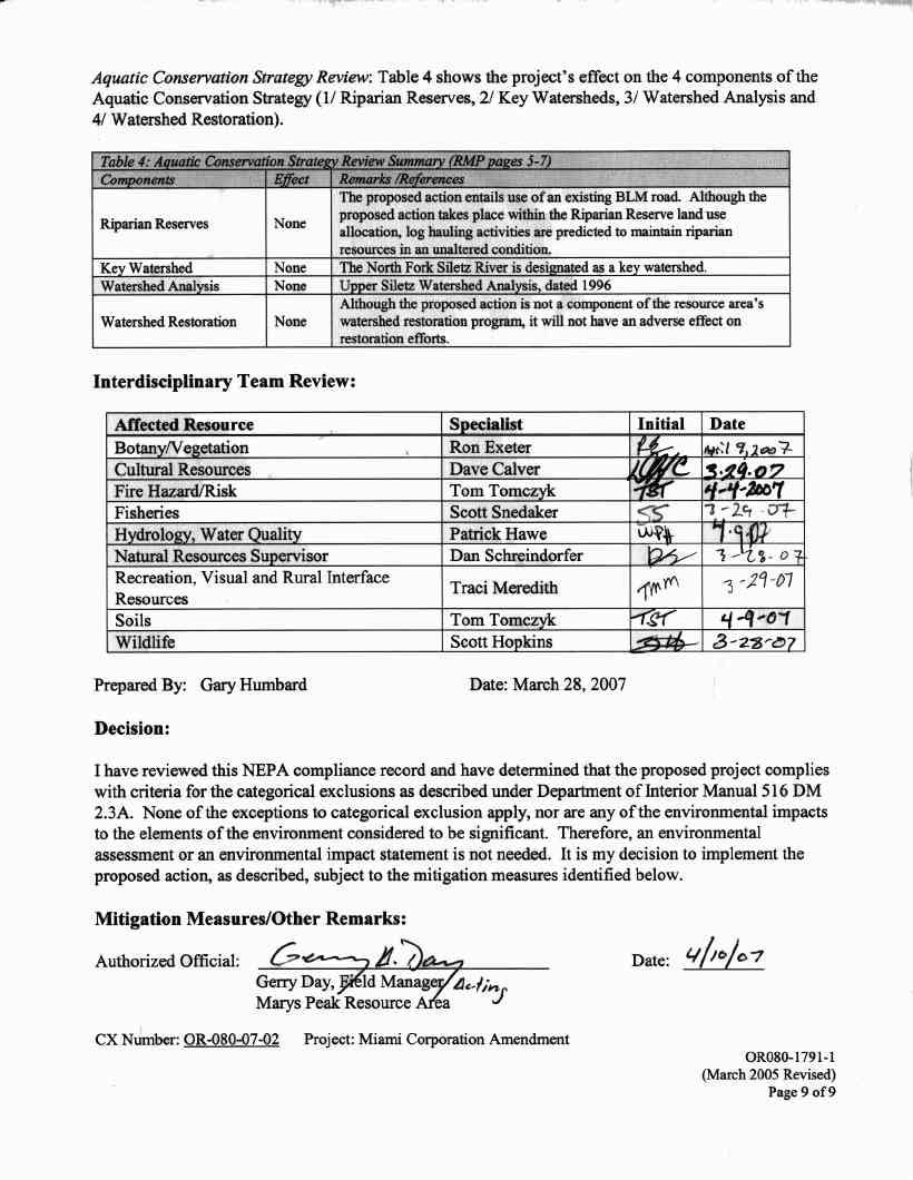
9
The project will be conducted in partnership with the Nez Perce Tribe.
 DECISION MEMO Tributary to Brushy Fork Culvert Replacements Private Land USDA Forest Service, Northern Region Powell Ranger District Nez Perce Clearwater National Forests Idaho County, Idaho I. Decision
DECISION MEMO. West Fork Blacktail Deer Creek Hardened Crossing
 Page 1 of 6 Background DECISION MEMO USDA Forest Service Madison Ranger District Madison County T12S, R4W, Section 30 The project is in the Gravelly Landscape, Snowcrest Recommended Wilderness Management
In Reply Refer To: 5400/1792 (OR-120) OR Mister Slate CT Timber Sale EA OR Slater Rocks Environmental Assessment.
 OR Mister Slate CT Timber Sale EA OR Slater Rocks Environmental Assessment.") In Reply Refer To: United States Department of the Interior BUREAU OF LAND MANAGEMENT COOS BAY DISTRICT OFFICE 1300 AIRPORT LANE, NORTH BEND, OR 97459 Web Address: http://www.blm.gov/or/districts/coosbay
In Reply Refer To: United States Department of the Interior BUREAU OF LAND MANAGEMENT COOS BAY DISTRICT OFFICE 1300 AIRPORT LANE, NORTH BEND, OR 97459 Web Address: http://www.blm.gov/or/districts/coosbay
BANFIELD #9 LODE CLAIM (Plan of Operations) Umpqua National Forest Tiller Ranger District June, 2011
 Umpqua National Forest Tiller Ranger District June, 2011") United States Department of Agriculture Forest Service Pacific Northwest Region BANFIELD #9 LODE CLAIM (Plan of Operations) Umpqua National Forest Tiller Ranger District June, 2011 ii Introduction and
United States Department of Agriculture Forest Service Pacific Northwest Region BANFIELD #9 LODE CLAIM (Plan of Operations) Umpqua National Forest Tiller Ranger District June, 2011 ii Introduction and
SAN LUIS VALLEY PUBLIC LANDS CENTER
 Decision Notice And Finding of No Significant Impact Watershed and Fisheries Conservation Treatments SAN LUIS VALLEY PUBLIC LANDS CENTER USDA Forest Service Rocky Mountain Region Public Lands Center Rio
Blanche Park Reservoir Decision Notice and Finding of No Significant Impact
 Blanche Park Reservoir Decision Notice and Finding of No Significant Impact U.S. Forest Service Grand Mesa, Uncompahgre, and Gunnison National Forests Delta County, Colorado INTRODUCTION The Grand Mesa
3-13 Other Required Findings and Regulatory Compliance
 Affected Environment and Environmental Consequences 3-13 Other Required Findings and Regulatory Compliance 3-13.1 Short-term Uses and Long-term Productivity NEPA requires consideration of the relationship
Preliminary Decision Memo 2015 Recreation Residence Projects Odell Lake
 2015 Recreation Residence Projects Odell Lake USDA Forest Service Crescent Ranger District, Deschutes National Forest Klamath County, Oregon Background The Crescent Ranger District maintains 66 recreation
DECISION MEMO Divide Creek Barrier Enhancement
 Page 1 of 7 Background DECISION MEMO USDA Forest Service Butte Ranger District Silver Bow County, Montana T. 2 N., R. 9 W., Section 32 The North Fork of Divide Creek is approximately 4 miles west of the
Keefer Pasture Drift Fence Project. Challis-Yankee Fork Ranger District Salmon-Challis National Forest
 Keefer Pasture Drift Fence Project Challis-Yankee Fork Ranger District Salmon-Challis National Forest PROPOSED ACTION The Challis-Yankee Fork Ranger District proposes construction of approximately.11 miles
Notice of Availability of the Final Environmental Impact Statement for the Monument
 This document is scheduled to be published in the Federal Register on 06/24/2016 and available online at http://federalregister.gov/a/2016-15023, and on FDsys.gov 4310-DQ-P DEPARTMENT OF THE INTERIOR Bureau
PROPOSED ACTION Cooperative Horse Removal with Fort McDermitt Paiute-Shoshone Tribe
 PROPOSED ACTION Cooperative Horse Removal with Fort McDermitt Paiute-Shoshone Tribe Proposed Action The Santa Rosa Ranger District of the Humboldt-Toiyabe National Forest is proposing to remove all unauthorized
MANTI-LA SAL NATIONAL FOREST
 MANTI-LA SAL NATIONAL FOREST FERRON RANGER DISTRICT CATEGORICAL EXCLUSION REVIEW FILE NUMBER: 2240 PROJECT TITLE: Olsen-McCadden Livestock Water Development PROJECT LEAD: Steven Cox ESTIMATED DATE FOR
Chapter 10 Natural Environment
 Chapter 10 Natural Environment Existing Conditions The Natural Environment Element addresses the protection, conservation, preservation, and restoration of the natural resources the Bayview Ridge Subarea,
Environmental Information Worksheet
 Environmental Information Worksheet Water System Owner (Attach additional sheets if necessary) Needs and Alternatives Provide a brief narrative that describes: Current drinking water system needs. Project
Proposed New Type and Diameter (ft)* T30N, R6E, Sec. 5, NW¼ NW¼- South Fork Clear Creek. Diameter (ft)
* T30N, R6E, Sec. 5, NW¼ NW¼- South Fork Clear Creek. Diameter (ft)") DECISION MEMO CLEAR CREEK CULVERTS REPLACEMENTS USDA Forest Service, Northern Region Moose Creek Ranger District, Nez Perce National Forest Idaho County, Idaho I. Decision I have decided to authorize replacement
DECISION MEMO CLEAR CREEK CULVERTS REPLACEMENTS USDA Forest Service, Northern Region Moose Creek Ranger District, Nez Perce National Forest Idaho County, Idaho I. Decision I have decided to authorize replacement
Municipal Stormwater Management Planning
 Municipal Stormwater Management Planning Christopher C. Obropta, Ph.D., P.E. Water Resources Extension Specialist with Rutgers Cooperative Extension Assistant Professor with Department of Environmental
CHAPTER 3 Environmental Guidelines for WATERCOURSE CROSSINGS GOVERNMENT OF NEWFOUNDLAND AND LABRADOR DEPARTMENT OF ENVIRONMENT AND LABOUR
 GOVERNMENT OF NEWFOUNDLAND AND LABRADOR DEPARTMENT OF ENVIRONMENT AND LABOUR CHAPTER 3 Environmental Guidelines for WATERCOURSE CROSSINGS WATER RESOURCES MANAGEMENT DIVISION Water Investigations Section
DECISION NOTICE FINDING OF NO SIGNIFICANT IMPACT (FONSI)
") DECISION NOTICE AND FINDING OF NO SIGNIFICANT IMPACT (FONSI) FOR CASA LOMA RECREATION RESIDENCE PERMIT RENEWAL U.S. FOREST SERVICE CIBOLA NATIONAL FOREST SANDIA RANGER DISTRICT BERNALILLO COUNTY, NEW MEXICO
DECISION NOTICE AND FINDING OF NO SIGNIFICANT IMPACT (FONSI) FOR CASA LOMA RECREATION RESIDENCE PERMIT RENEWAL U.S. FOREST SERVICE CIBOLA NATIONAL FOREST SANDIA RANGER DISTRICT BERNALILLO COUNTY, NEW MEXICO
The status of aquatic ecosystems in the Basin
 AQUATIC SPECIES AND HABITATS The status of aquatic ecosystems in the Basin is influenced by both natural and human processes. The geologic and geomorphic processes described earlier formed and continue
PROJECT INFORMATION Manchester Ranger District Apple Tree Release and Maintenance Project
 PROJECT INFORMATION Manchester Ranger District Apple Tree Release and Maintenance Project The USDA Forest Service is proposing to release and prune living apple trees in the Manchester Ranger District,
East Fork Illinois River Restoration
 United States Department of Agriculture East Fork Illinois River Restoration Final Decision Notice and Finding of No Significant Impact Responsible Official: Matthew Paciorek District Ranger Wild Rivers
CHAPTER 9 DISCUSSIONS, CONCLUSIONS, AND RECOMMENDATIONS
 CHAPTER 9 DISCUSSIONS, CONCLUSIONS, AND RECOMMENDATIONS This chapter summarizes the results of feasibility level investigations undertaken to identify solutions to the water and related land resource problems
East Fork Illinois River Restoration
 United States Department of Agriculture East Fork Illinois River Restoration Draft Decision Notice and Finding of No Significant Impact Responsible Official: Matthew Paciorek District Ranger Wild Rivers
Draft Decision Notice Maroon Bells - Snowmass Wilderness Overnight Visitor Use Management Plan
 Draft Decision Notice Maroon Bells - Snowmass Wilderness Overnight Visitor Use Management Plan USDA Forest Service Aspen-Sopris Ranger District, White River National Forest Gunnison Ranger District, Grand
Chapter 4 Watershed Goals and Objectives
 Chapter 4 Watershed Goals and Objectives Eight (8) long-term watershed goals have been developed by the NEW Watershed Advisory Group (WAG) after consideration of discussions held during monthly watershed
Decision Notice and Finding of No Significant Impact
 Decision Notice and Finding of No Significant Impact Gold Lake Bog Research Natural Area Boundary Adjustment and Nonsignificant Forest Plan Amendment #53 USDA Forest Service Middle Fork Ranger District,
Environmental Assessment for Road Diobsud Road Repairs
 United States Department of Agriculture Forest Service Pacific Northwest Region Environmental Assessment for Road Diobsud Road Repairs Contents Chapter 1 purpose of and need for action... 3 Introduction...
PLAN CATEGORICAL EXCLUSION QUESTIONS AND ANSWERS
 PLAN CATEGORICAL EXCLUSION QUESTIONS AND ANSWERS What is a Categorical Exclusion? Categorical exclusions are an essential part of NEPA that provide a categorical determination, based on agency experience,
Nationwide Permit General Conditions
 Nationwide Permit General Conditions Note: To qualify for NWP authorization, the prospective permittee must comply with the following general conditions, as applicable, in addition to any regional or case-specific
JUNE 20, Collaborative Initiatives: Restoring watersheds and large landscapes across boundaries through State and Federal partnerships
 TESTIMONY of LESLIE WELDON DEPUTY CHIEF, NATIONAL FOREST SYSTEM UNITED STATES DEPARTMENT OF AGRICULTURE FOREST SERVICE BEFORE THE SENATE COMMITTEE ON ENERGY AND NATURAL RESOURCES SUBCOMMITTEE ON PUBLIC
Proposed Action Report Big Creek WBP Enhancement Project
 Proposed Action Report Big Creek WBP Enhancement Project USDA Forest Service Cascade Ranger District Boise National Forest Valley County, Idaho July 2013 PURPOSE AND NEED FOR THE PROPOSED ACTION The encroachment
Wind Energy Development Specialist Report
 United States Department of Agriculture Forest Service Southwestern Region Cibola National Forest and National Grasslands Wind Energy Development Specialist Report Kiowa, Rita Blanca, Black Kettle and
INTRODUCTION. Page 1 of 24. Consent decision with certain Specified Conditions (stipulations) listed in Attachment P.L , as amended 3
 listed in Attachment P.L , as amended 3") DRAFT DECISION NOTICE & FINDING OF NO SIGNIFICANT IMPACT GOAT MOUNTAIN HARDROCK MINERAL PROSPECTING PERMITS USDA FOREST SERVICE, GIFFORD PINCHOT NATIONAL FOREST COWLITZ VALLEY RANGER DISTRICT SKAMANIA
DRAFT DECISION NOTICE & FINDING OF NO SIGNIFICANT IMPACT GOAT MOUNTAIN HARDROCK MINERAL PROSPECTING PERMITS USDA FOREST SERVICE, GIFFORD PINCHOT NATIONAL FOREST COWLITZ VALLEY RANGER DISTRICT SKAMANIA
WATERSHED. Maitland Valley. Report Card 201
 Maitland Valley WATERSHED Report Card 201 The Maitland Valley Conservation Authority has prepared this report card as a summary on the state of our forests, wetlands, surface water, and ground water resources.
TORCH LAKE TOWNSHIP WATER QUALITY ACTION PLAN
 TORCH LAKE TOWNSHIP WATER QUALITY ACTION PLAN Elk-River-Chain-of-Lakes Gaps Analysis Project The Watershed Center Grand Traverse Bay Tip of the Mitt Watershed Council Michigan Department of Natural Resources
Wildlife Conservation Strategy
 Wildlife Conservation Strategy Boise National Forest What is the Wildlife Conservation Strategy? The Boise National Forest is developing a Wildlife Conservation Strategy (WCS) in accordance with its Land
Draft Decision Notice and Finding of No Significant Impact. Pack II Road Decommissioning Project. United States Department of Agriculture
 Draft Decision Notice and Finding of No Significant Impact United States Department of Agriculture Pack II Road Decommissioning Project Powell Ranger District, Nez Perce-Clearwater National Forests Idaho
CHEAT MOUNTAIN WILDLIFE HABITAT ENHANCEMENT
 United States Department of Agriculture Forest Service Monongahela National Forest Greenbrier Ranger District Box 67 Bartow, WV 24920 304-456-3335 CHEAT MOUNTAIN WILDLIFE HABITAT ENHANCEMENT USDA Forest
Highlights of South Platte Protection Plan
 Summer, 2001 Highlights of South Platte Protection Plan The South Platte Protection Plan has been developed by local communities and interested parties to protect and enhance natural and recreational values
Natural Resources and Climate Resiliency in Germantown
 Natural Resources and Climate Resiliency in Germantown Ingrid Haeckel, Andrew Meyer, and Elizabeth Murphy NYSDEC Hudson River Estuary Program and Cornell University Presentation to the Town of Germantown,
Northwest Forest Plan Aquatic Conservation Strategy
 Northwest Forest Plan Aquatic Conservation Strategy The Implementation of the Northwest Forest Plan Aquatic Conservation Strategy on BLM and FS-administered lands within the Oregon Coastal Coho ESU Submitted
Lake Britton Planning Unit. Fish, Plant, and Wildlife Habitat LAKE BRITTON PLANNING UNIT
 LAKE BRITTON PLANNING UNIT Pit-McCloud River Watershed Lake Britton Planning Unit Fish, Plant, and Wildlife Habitat Conduct surveys of lands outside the FERC boundary to identify biological resources and
Chapter 3 Affected Environment and Environmental Consequences
 Sterling Highway MP 45 60 Draft SEIS and Draft Section 4(f) Evaluation Chapter 3 Affected Environment and Environmental Consequences Prepared for: Alaska Department of Transportation and Public Facilities
RIPARIAN PROTECTION Questions & Answers
 RIPARIAN PROTECTION Questions & Answers 1. What is a riparian corridor and why is it important? Answer: A riparian corridor is a space on both sides of a stream or around a lake or wetland. The corridor
WATERSHED MANAGEMENT INITIATIVE: GOALS & IMPLEMENTATION OBJECTIVES, JULY 26, 1999
 WATERSHED MANAGEMENT INITIATIVE: GOALS & IMPLEMENTATION OBJECTIVES, JULY 26, 1999 The following table indicates the draft goals and objectives for the Santa Clara Basin WMI process. The overall objectives
Water and Environment. Monterey Peninsula, Carmel Bay and South Monterey Bay Integrated Regional Water Management Draft Plan
 Water and Environment Monterey Peninsula, Carmel Bay and South Monterey Bay Integrated Regional Water Management Draft Plan December 11, 2006 Presentation Outline Purpose of IRWM Planning Status of Plan
Hat Creek Planning Unit. Fish, Plant, and Wildlife Habitat. LCP Volume II Supporting Analysis for Recommendations
 Hat Creek Planning Unit Fish, Plant, and Wildlife Habitat Conduct surveys of the planning unit to identify biological resources and enable their protection. Though a partial survey of botanical resources
Payette National Forest
 United States Department of Agriculture Forest Service Payette National Forest 800 W Lakeside Ave McCall ID 83638-3602 208-634-0700 File Code: 1570 Date: December 20, 2010 Debra K. Ellers Western Idaho
Chapter 13: Wildlife and Vegetation
 Chapter 13: Wildlife and Vegetation Introduction and Setting Nevada County contains an extremely wide range of plants, animals and habitat types. With topographic elevations ranging from 300 feet in the
Draft Decision Notice and Finding of No Significant Impact (DN/FONSI)
") United States Department of Agriculture Forest Service January 2016 Draft Decision Notice and Finding of No Significant Impact (DN/FONSI) Rock Creek Vegetation and Fuels Healthy Forest Restoration Act
United States Department of Agriculture Forest Service January 2016 Draft Decision Notice and Finding of No Significant Impact (DN/FONSI) Rock Creek Vegetation and Fuels Healthy Forest Restoration Act
POLICY FOR NATURAL RESOURCE MANAGEMENT AREAS
 POLICY FOR NATURAL RESOURCE MANAGEMENT AREAS I. POLICY STATEMENT Auburn University's (the University's) "Policy for Natural Resource Management Areas" implements the Campus Master Plan Land Use Element
Paradise and Watson Creek Headcut Treatment Project (see map on next page)
") Paradise and Watson Creek Headcut Treatment Project (see map on next page) T 34 S, R 15 E, Sections 11, 13 and 14 The purpose of the project would be to stabilize the stream channel by treating headcuts
Paradise and Watson Creek Headcut Treatment Project (see map on next page) T 34 S, R 15 E, Sections 11, 13 and 14 The purpose of the project would be to stabilize the stream channel by treating headcuts
3.6 Riparian Ecosystem Wildlife
 3.6 Riparian Ecosystem Wildlife 3.6.1 Introduction and Methodology Riparian areas and associated wetlands are widely recognized for the significant and diverse roles they play in the landscape. They clean
Part 3B: Policy for the Evaluation of Conservation Efforts: The Certainty That the Conservation Effort Will Be Effective
 Coho Assessment Part 3B: PECE Final Report May 6, 2005 Oregon Coastal Coho Assessment Part 3B: Policy for the Evaluation of Conservation Efforts: The Certainty That the Conservation Effort Will Be Effective
SKAGIT COUNTY PLANNING AND DEVELOPMENT SERVICES FINDINGS OF FACT. APPLICATION NUMBER: Shoreline Substantial Development Application PL
 SKAGIT COUNTY PLANNING AND DEVELOPMENT SERVICES FINDINGS OF FACT HEARING AUTHORITY: Skagit County Hearing Examiner HEARING DATE: April 24, 2013 APPLICATION NUMBER: Shoreline Substantial Development Application
Cedar River Watershed Habitat Conservation Plan
 Cedar River Watershed Habitat Conservation Plan Briefing for the WRIA 8 Salmon Recovery Council November 21, 2013 Cyndy Holtz Seattle Public Utilities cyndy.holtz@seattle.gov What is an HCP? Habitat Conservation
SKIBO PROJECT SCOPING REPORT Laurentian Ranger District, Superior National Forest
 SKIBO PROJECT SCOPING REPORT Laurentian Ranger District, Superior National Forest I. Introduction The Laurentian Ranger District of the Superior National Forest is proposing management activities within
West Branch LeClerc Creek Watershed Restoration Project Environmental Assessment
 West Branch LeClerc Creek Watershed Restoration Project Environmental Assessment Decision Notice, Finding of No Significant Impact, and Response to Public Comments April 2015 USDA Forest Service Colville
COON CREEK WATERSHED DISTRICT PERMIT REVIEW. Spring Lake Park Schools Westwood Middle School st Avenue NE, Spring Lake Park, MN 55432
 PAN 16-112, Westwood Middle School, Page 1 of 6 COON CREEK WATERSHED DISTRICT PERMIT REVIEW MEETING DATE: August 22, 2016 AGENDA NUMBER: 10 FILE NUMBER: 16-112 ITEM: Westwood Middle School RECOMMENDATION:
DECISION NOTICE AND FINDING OF No SIGNIFICANT IMPACT HOPKINS FIRE SALVAGE
 DECISION NOTICE AND FINDING OF No SIGNIFICANT IMPACT HOPKINS FIRE SALVAGE DECISION U.S. FOREST SERVICE OCALA NATIONAL FOREST SEMINOLE RANGER DISTRICT MARION COUNTY, FLORIDA Based upon my review of the
East Fork Illinois River Channel and Floodplain Restoration Project
 East Fork Illinois River Channel and Floodplain Restoration Project Wild Rivers Ranger District, Rogue River-Siskiyou National Forest /s/ Joni D. Brazier Date: February 20, 2015 Joni D. Brazier, Forest
LAW OFFICE OF BRETT VANDENHEUVEL 620 SW MAIN ST., STE 615, PORTLAND, OR OFFICE: , CELL:
 Attorneys At L LAW OFFICE OF BRETT VANDENHEUVEL 620 SW MAIN ST., STE 615, PORTLAND, OR 97205 OFFICE: 503 224 3240, CELL: 503 348 2436 Mr. James D. Green U.S. Army Corps of Engineers Regulatory Branch P.O.
Public Notice. Applicant: City of Dallas Project No.: SWF Date: April 18, Name: Chandler Peter Phone Number:
 Public Notice Applicant: City of Dallas Project No.: SWF- 2014-00151 Date: April 18, 2014 The purpose of this public notice is to inform you of a proposal for work in which you might be interested. It
Linda Cooper, Eno River State Park, Durham, NC
 Linda Cooper, Eno River State Park, Durham, NC 2 Rivers and Streams All 50 states, 2 interstate river commissions, American Samoa, Guam, Puerto Rico, the District of Columbia (collectively referred to
Marcellus Shale Gas Development in Maryland: A Natural Resource Analysis
 Marcellus Shale Gas Development in Maryland: A Natural Resource Analysis Advisory Commission Meeting February 27, 2012 Garrett County Economic Development map Catherine McCall Balancing Natural Resources
The McKenzie River Watershed Conservation Strategy
 The McKenzie River Watershed Conservation Strategy January 2002 The McKenzie Watershed Council Fostering better stewardship of McKenzie Watershed resources through voluntary partnerships and collaboration.
DECISION MEMO IDAHO DREAM PLAN OF OPERATIONS
 Page 1 of 7 BACKGROUND DECISION MEMO USDA Forest Service Dillon Ranger District Beaverhead County The project area is included in the Ermont Mining District in T5S R11W Section 36 and T6S R11W Section
EFFECT OF UPSTREAM DEVELOPMENT ON THE CLEAR CREEK AREA
 EFFECT OF UPSTREAM DEVELOPMENT ON THE CLEAR CREEK AREA Technical Memorandum Farming in the Floodplain Project Prepared for May 2017 PCC Farmland Trust Photo credit: Google Earth TABLE OF CONTENTS Page
Sustainable Non-Agriculture Land Management
 Forest, Wetlands and Habitat Verification Checklist A boxed risk level indicates the level required for environmental assurance verification. Bold black print indicates a violation of state or federal
DEPARTMENT OF ENVIRONMENTAL PROTECTION Bureau of Water Quality Protection. Design Criteria - Wetlands Replacement/Monitoring
 DEPARTMENT OF ENVIRONMENTAL PROTECTION Bureau of Water Quality Protection DOCUMENT NUMBER: 363-0300-001 TITLE: Design Criteria - Wetlands Replacement/Monitoring EFFECTIVE DATE: February 11, 1997 AUTHORITY:
MONITORING QUESTIONS AND TASKS FOR THE GEORGE WASHINGTON PLAN
 MONITORING QUESTIONS AND TASKS FOR THE GEORGE WASHINGTON PLAN MONITORING THEME 1 CONSERVATION OF BIOLOGICAL DIVERSITY FOR ECOSYSTEMS MQ 1: How are ecological conditions maintaining or making progress toward
Planning and Combination (Planning and Acquisition) Project Proposal
 Project Proposal") Planning and Combination (Planning and Acquisition) Project Proposal Project Number 15-1308 Project Name Asotin County Geomorphic/Watershed Assessment Sponsor Asotin County Conservation District List all
Planning and Combination (Planning and Acquisition) Project Proposal Project Number 15-1308 Project Name Asotin County Geomorphic/Watershed Assessment Sponsor Asotin County Conservation District List all
APPENDIX H Guidance for Preparing/Reviewing CEQA Initial Studies and Environmental Impact Reports
 APPENDIX H H.1 Guidance for Preparing and Reviewing CEQA Initial Studies Step 1: Consider the Project Characteristics as Provided by the Project Applicant Review the project application and draft plan
Salmon River Recreation Sites Renovation Decision Notice and FONSI
 SALMON RIVER RECREATIONAL SITES RENOVATION PROJECT DECISION NOTICE & FINDING OF NO SIGNIFICANT IMPACT USDA FOREST SERVICE SALMON RIVER RANGER DISTRICT, NEZ PERCE NATIONAL FOREST IDAHO COUNTY, IDAHO 1.1
PUBLIC NOTICE. REPLY TO: Denver Regulatory Office 9307 South Wadsworth Blvd 30 DAY NOTICE Littleton, CO FAX (303)
") PUBLIC NOTICE US Army Corps of Engineers Omaha District Application No: NWO-2017-01366-DEN Project: Douglas Lane Tributary Stabilization Project Applicant: Town of Castle Rock Waterway: Douglas Lane Tributary
PUBLIC NOTICE US Army Corps of Engineers Omaha District Application No: NWO-2017-01366-DEN Project: Douglas Lane Tributary Stabilization Project Applicant: Town of Castle Rock Waterway: Douglas Lane Tributary
ADMINISTRATIVE UNIT: Shasta Trinity National Forest, Trinity River Management Unit (TRMU)
") SHASTA-TRINITY NATIONAL FOREST Fisheries Specialist Report for the Misery Hill Trail Trinity River Management Unit PROJECT NAME: MISERY HILL TRAIL PROJECT ADMINISTRATIVE UNIT: Shasta Trinity National Forest,
SHASTA-TRINITY NATIONAL FOREST Fisheries Specialist Report for the Misery Hill Trail Trinity River Management Unit PROJECT NAME: MISERY HILL TRAIL PROJECT ADMINISTRATIVE UNIT: Shasta Trinity National Forest,
Decision Memo Tongass National Forest. Wrangell Ranger District. Pre-Commercial Thinning CE 2010
 Decision Memo Tongass National Forest Pre-Commercial Thinning CE 2010 Decision It is my decision to authorize pre-commercial thinning (PCT) on approximately 7,500 acres of overstocked young-growth forest
Public Rock Collection
 Public Rock Collection Eagle-Holy Cross Ranger District, White River national Forest Eagle County, Colorado T7S, R80W, Section 18 & T6S, R84W, Section 16 Comments Welcome The Eagle-Holy Cross Ranger District
New Castle County, DE. Floodplain Regulations
 New Castle County, DE Floodplain Regulations John J. Gysling, PE CFM Department of Land Use New Castle County, DE February 26, 2009 Today s Presentation Floodplain Protection and Uses Terms and Definitions
Mechanical Site Preparation
 Mechanical Site Preparation 1 Mechanical Site Preparation Introduction...3 CONTENTS The Benefits of Guidelines...3 Considerations...5 Design Outcomes To Maintain Soil Productivity...6 Planning...7 Planning
King County Flood Control District approves grants for flood prevention projects Regional projects to benefit from district funds
 News Release Contact: Al Sanders 206-477-1016 August 31, 2015 Flood Control District approves grants for flood prevention projects Regional projects to benefit from district funds The Flood Control District
Chapter 1: Purpose and Need and Proposed Action
 BUTTERMILK TOILET CONSTRUCTION PROJECT White Mountain Ranger District, Inyo National Forest Inyo County, CA Chapter 1: Purpose and Need and Proposed Action Purpose and Need Over the last 20 years, there
DECISION MEMO. Non-Commercial Thinning on the Ocala National Forest (PALS project # 39238)
") Decision DECISION MEMO Non-Commercial Thinning on the Ocala National Forest (PALS project # 39238) USDA Forest Service Ocala National Forest Lake, Marion, and Putnam County, Florida Based on the analysis
Decision DECISION MEMO Non-Commercial Thinning on the Ocala National Forest (PALS project # 39238) USDA Forest Service Ocala National Forest Lake, Marion, and Putnam County, Florida Based on the analysis
Joint Public Notice. LOCATION: In Salmon Bay, Lake Washington Ship Canal, at Seattle, Washington.
 US Army Corps of Engineers Seattle District Joint Public Notice Application for a Department of the Army Permit and a Washington Department of Ecology Water Quality Certification and/or Coastal Zone Management
STREAM AND BUFFER AREA PROTECTION/RESTORATION
 STREAM AND BUFFER AREA PROTECTION/RESTORATION AMENDMENT OPTIONS TO STRENGTHEN POLICY IN HEADWATERS AREAS DRAFT SUBSEQUENT TO THE JANUARY 25, 2007 MEETING OF THE PLANNING COMMISSION ENVIRONMENT COMMITTEE
Chase Red Pine Fuels Project
 United States Department of Agriculture Chase Red Pine Fuels Project Draft Decision Notice and Finding of No Significant Impact USDA Forest Service, Huron-Manistee National Forests Lake and Newaygo Counties,
PUBLIC NOTICE. Dredging with ten-years maintenance, return flow to the waterway and upland placement. Georgica Cove, tributary of Georgica Pond
 PUBLIC NOTICE US Army Corps of Engineers New York District Jacob K. Javits Federal Building New York, N.Y. 10278-0090 ATIN: Regulatory Branch In replying refer to: Public Notice Number: NAN-2016-01054-EHA
Instructions for the South Pacific Division Nationwide Permit Pre- Construction Notification (PCN):
:") This PCN integrates the requirements of the U.S. Army Corps of Engineers (Corps) Nationwide Permit Program within the South Pacific Division (SPD), including the Albuquerque, Los Angeles, San Francisco,
This PCN integrates the requirements of the U.S. Army Corps of Engineers (Corps) Nationwide Permit Program within the South Pacific Division (SPD), including the Albuquerque, Los Angeles, San Francisco,
Project Goals and Scoping
 Prepared for: Boulder County, Colorado Flood Planning & Preliminary Design Services for South St. Vrain Creek Restoration at Hall Ranch and Scoping May 24, 2016 Meeting with General Public In association
Department of the Army Permit Application
 Department of the Army Permit Application DA File Number U.S. Army Corps of Engineers Honolulu District Date Received by CEPOH-RO Send Completed Application to: Honolulu District, U.S. Army Corps of Engineers
Long-term Management Plan For The Mitigation Bank
 Note: The California multi-agency Project Delivery Team developed this general outline to assist in the development of the Long-term Management Plan for mitigation banks. Objectives and tasks are provided
Annex F Scoping Checklist
 Scoping Checklist Table F1: Scoping Checklist Table. Questions to be considered in Scoping /? Which Characteristics of the Project 1. Will construction, operation or decommissioning of the Project involve
RIVERSIDE OXBOW FORT WORTH, TEXAS CHAPTER 3 IDENTIFICATION OF PROBLEMS AND OPPORTUNITIES
 RIVERSIDE OXBOW FORT WORTH, TEXAS CHAPTER 3 IDENTIFICATION OF PROBLEMS AND OPPORTUNITIES Regular study team meetings were held with the Tarrant Regional Water District, the USFWS, Streams and Valleys,
Rattlesnake Mountain OHV Trails
 Rattlesnake Mountain OHV Trails Location The project area is approximately 8,000 acres in size and is located in the vicinity of Rattlesnake Mountain and southeast to Big Pine Flat. The area is generally
Nestlé Waters North America Inc. Special Use Permit San Bernardino National Forest Project Proposal
 Nestlé Waters North America Inc. Special Use Permit San Bernardino National Forest Project Proposal 1. Introduction This document describes the project proposal for the short term (5 year) authorization
Environmental Assessment Sandy River Delta Section 536 Ecosystem Restoration Project Multnomah County, Oregon
 Environmental Assessment Sandy River Delta Section 536 Ecosystem Restoration Project Multnomah County, Oregon East Channel Dam under Construction, Sandy River Delta, 1930s February 2013 Table of Contents
DETAILED IMPACT ANALYSIS OF MARMOT BASIN LONG RANGE PLAN
 2.0 JURISDICTION Parks Canada s decisions about the acceptability of proposals presented in the LRP are guided by a number of regulatory instruments and policies, the most relevant of which are described
STETSON ENGINEERS INC. HANSON ENVIRONMENTAL,INC. IBIS ENVIRONMENTAL SERVICES. February 2004 Revised
 FINAL DRAFT ARROYO GRANDE CREEK HABITAT CONSERVATION PLAN (HCP) AND ENVIRONMENTAL ASSESSMENT/INITIAL STUDY (EA/IS) FOR THE PROTECTION OF STEELHEAD AND CALIFORNIA RED-LEGGED FROGS February 2004 Revised