PUBLIC OPEN HOUSE #2 GRAND NIAGARA SECONDARY PLAN. Date: Time: Place:
|
|
|
- Edward Kelly
- 6 years ago
- Views:
Transcription


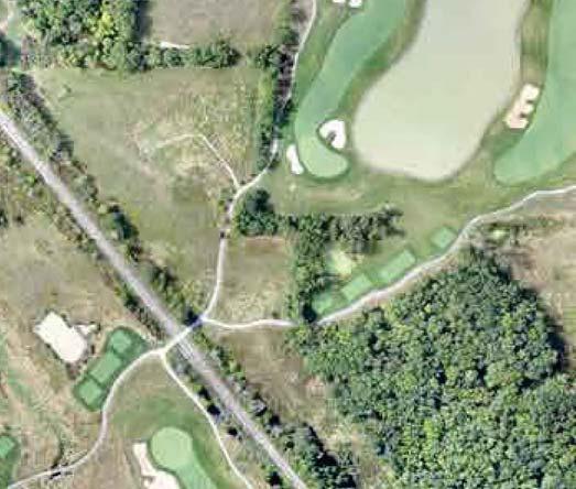
1 GRAND NIAGARA SECONDARY PLAN PUBLIC OPEN OUSE #2 WELLAND RIVER GRASSY BROOK ROAD MONTROSE ROAD CROWLAND ROAD QUEEN ELIZABET WAY BIGGAR ROAD (Source: Google Maps 2015) Date: Time: Place: June 15, :00 pm to 6:00 pm Grand Niagara Golf Club Clubhouse 8547 Grassy Brook Road


2 CONTEXT PLAN Regional Municipality of Niagara STUDY AREA Niagara Falls QUEEN ELIZABET WAY STUDY AREA Biggar Road Montrose Road Lyons Creek Road

3 SITE CONTEXT WELLAND RIVER 7 3 GRASSY BROOK ROAD STUDY AREA CROWLAND ROAD 1 CN RAIL LINE AND YDRO CORRIDOR 2 4 MONTROSE ROAD QUEEN ELIZABET WAY BIGGAR ROAD (Source: Google Maps 2015) 1 Existing Grand Niagara Golf Course with Resort Residential Land Use Permissions 2 Future Regional ospital Site 3 ES Fox Ltd. Offices 4 Existing Employment Uses 5 Thundering Waters Secondary Plan Area (ongoing) 6 Garner South Secondary Plan Area (complete) 7 Region of Niagara Bio-Solids Facility 8 Cytec Industries Inc.


4 SCOPE OF STUDY MMM Group Limited in conjunction with The Planning Partnership is working with the City of Niagara Falls, Niagara Region, the Niagara Peninsula Conservation Authority, and various public agencies to prepare a Secondary Plan for Grand Niagara. The Grand Niagara Secondary Plan will establish a framework for the future land development of the area working within the context of the site s physical characteristics, natural heritage features, and stormwater management and servicing capabilities. The Secondary Plan will be consistent with the City s Growth Strategy and projected housing needs, the Provincial Policy Statement and Growth Plan for the Greater Golden orseshoe. secondary plan process The Secondary Plan process will amend the City of Niagara Falls Official Plan and establish a clear vision and goals for the area, establish the densities and policies required to achieve the vision, and meet the requirements of the Provincial Framework. timeline The Secondary Plan is intended to be completed in three phases as outlined below: Phase I Pre-Consultation Meeting, Concept Refinement and Scope Confirmation June 2015 August 2015 Phase II-A Supporting Technical Studies and Background Report Public Open ouse #1 - December 2, 2015 Public Open ouse #2 - June 15, 2016 August 2015 June 2016 WE ARE ERE Phase II-B Secondary Plan Public Open ouse #3 - TBC Fall / Winter 2016 Statutory Public Meeting - Winter 2016 / 2017 June 2016 January 2017 Phase III Zoning By-Law Amendment and Draft Plan of Subdivision January 2017 June 2017


5 PLANNING CONTEXT Provincial Policies Provincial Policy Statement (PPS), 2014 The PPS provides policy direction on matters of Provincial interest relating to land use planning and development and is issued under Section 3 of the Planning Act. Section 1.0 sets out policies associated with efficient land use and development patterns that support liveable, healthy, and safe communities, protect the environment, and public health and safety, and facilitate economic growth. Section 1.0 also sets out policies relating to: Land use compatibility stating that major facilities and sensitive land use should be planned to ensure they are appropriately designed, buffered and/or separated from each other to prevent or mitigate adverse effects (Section ); and Employment requiring municipalities to plan for, protect and preserve employment areas, as well as encouraging the promotion of economic development and competitiveness by providing for an appropriate mix and range of employment and institutional uses, and opportunities for diversifying the economic base (Section and ). Section 2.0 addresses wise use and management of resources, including protection of natural heritage, water, agriculture, etc. Growth Plan for the Greater Golden orseshoe, 2006 Contains population and employment projections that form the basis for planning growth within municipalities and guides decisions on a wide range of land use planning issues, including transportation, infrastructure, urban form, housing, etc. Encourages municipalities to focus new growth within the Settlement Areas through the development of mixed-use, transit supportive and pedestrian friendly environments. The majority of the Secondary Plan area is within the Builtup Area and a portion is Designated Greenfield Area. The Region of Niagara is to plan for an ultimate population of 610,000 residents and 265,000 jobs by Contains policies relating to the protection of Employment Lands in order to promote economic development and competitiveness. Delineated Built-up Areas Greenbelt Area Region of Niagara Official Plan Niagara Region Official Plan, Schedule A Regional Structure Niagara Region Official Plan, Schedule C Core Natural eritage Niagara Region Official Plan, Schedule G1 Niagara Economic Gateway Niagara Region Official Plan, Schedule G2 Niagara Gateway Economic Employment Lands BA QEW NM 49 QEW 49 NM 70 NM 70 NM 70 NM NM 47 NM 47 NM 27 BA QEW NM 27 BA QEW


 up to 2-storeys Establishes a 1.09km separation distance (measured from the intersection of Garner Rd. and Chippawa Creek Rd.")
6 PLANNING CONTEXT City of Niagara Falls Official Plan Urban Structure Plan: Secondary Plan is within the Urban Boundary and is identified as being within the Built Up Area and the Greenfield Area Target density of development shall be no less than 53 people and jobs per hectare A portion of the lands are designated as QEW Employment Corridor which are intended to provide a long term base for the future development of uses that require access and exposure to the QEW. Within the QEW Employment Corridor, manufacturing, wholesaling, and logistics use are permitted, as well as large scale institutional uses that require access to the QEW. Current Land Use Designations: Official Plan Amendment (Special Policy Area 34) Permits a comprehensive golf course resort 650 hotel/vacation dwellings up to 5-storeys 225 resort dwelling units (singles, townhouses, multiple dwellings units) up to 2-storeys Establishes a 1.09km separation distance (measured from the intersection of Garner Rd. and Chippawa Creek Rd.) from heavy industrial facilities o Low intensity recreational uses, including golf course facilities and ancillary uses are permitted within this area Industrial (Employment) Permits range of employment and industrial uses, including uses such as: manufacturing, assembly, fabricating, processing, reclaiming, recycling, warehousing, distribution, laboratory and research, and storage uses. Tourist Commercial Environmental Protection


7 VISION secondary plan draft vision It is intended that the Secondary Plan Area will develop as an environmentally sustainable and healthy community with distinctive, liveable neighbourhoods, integrated and connected green spaces, efficient transportation and transit systems, and employment opportunities. secondary plan draft principles 1 Protect and restore natural heritage features. 2 Promote the responsible use of resources. 3 Promote Place-making. 4 Create a diverse community. 5 Promote active transportation. 6 Create a connected and integrated open space and trail system. 7 Create employment opportunities. 8 Manage growth.


8 draft principles and objectives Protect and restore natural heritage features 1 functional and highly interconnected integrated into the design of the community appropriate separation distances and buffers Promote the responsible use of resources ensure long-term sustainability, reduce greenhouse gas emissions, and reduce demands on energy, water, and waste systems municipal services provided in a cost effective and efficient manner 2 Promote place-making 3 vistas and view sheds to the Welland River instill a sense of civic pride improve the quality of the living environment through the distribution and access to parks and recreational facilities, shops, services and health care Create a diverse community range and mix of housing opportunities, choices, and accessibility for all income levels mix and diversity of land uses in a compact, active transportation supportive development form neighbourhood commercial uses, schools, and community facilities 4


 and neighbourhood parks within")


9 draft principles and objectives Promote active transportation 5 walkable and connected neighbourhoods with sufficient destinations within walking distance of residents economical, safe, and accessible mobility options through the provision of a connected network of streets, sidewalks, bicycle lanes, trails, and a future public transit system Create a connected and integrated open space and trail system parkettes within 200 metres (2-3 minute walk) and neighbourhood parks within 400 metres (5 minute walk) of residents all parks, open spaces, and trails are visible and accessible integrate schools and parks with the trail system 6 Create employment opportunities 7 opportunity for employment to be balanced with population, variety of employment uses throughout the community office uses and services associated with the Regional ospital site area land use compatibility between nonresidential and residential buildings niagarahealth.on.ca Manage growth that growth and development is fiscally sustainable create jobs concurrent with residential growth to ensure a long-term balanced economy Grand Niagara is to be designed to achieve a minimum net density of 50 residents and/or jobs per hectare, in conformity with Provincial directives 8
10 The following studies are being undertaken to support the Secondary Plan process. To date, background information has been collected and reviewed. During the Secondary Plan process, background information will be analyzed against the proposed Secondary Plan development to determine impacts and provide recommendations: BACKGROUND STUDIES Sanitary Sewer System Sanitary sewers exist on Montrose Road and Grassy Brook Road with pipe diameters ranging from 300mm to 450mm. Sanitary sewers drain into the existing Grassy Brook Sanitary Pumping Station (SPS), on the east side of Montrose Road. Existing commercial / industrial properties fronting onto Montrose Road and the existing Grand Niagara golf clubhouse and maintenance building either connect to the existing sewers or have allocation to connect. An additional leg of gravity sewer connects to the Grassy Brook SPS, providing sanitary service to the E.S. Fox factory north of the SPS. Grassy Brook SPS pumps sewage flow north via a 150mm diameter forcemain. SPS has two pumps: one pump operation can provide approximately L/s at 33 m TD and two pump operation increases output to approximately L/s at 45 m TD. SPS currently operates at 21L/s and has an ultimate capacity of 138 L/s. Proposed sanitary sewers will be designed in accordance with the City of Niagara Falls City Standards for Site Planning (April 1992) and Ministry of the Environment (MOE) criteria. Water Distribution System Study Area is supplied from the Niagara River via the Niagara Falls Water Treatment Plan and includes the following watermains: 300 mm diameter PVC watermain along Montrose Road which crosses the Welland River; 300 mm diameter PVC watermain along Grassy Brook Road; and 300 mm diameter DPE watermain which crosses the Welland River and connects watermain from Grassy Brook Road to Chippawa Creek Road. The watermain system is expected to meet long-term demands for the City and the Secondary Plan area. Design standards for the Study Area come from the MOE Design Guidelines for Drinking Water Systems (2008). Storm Drainage and Stormwater Management Proposed storm sewers will be designed in accordance with the City of Niagara Falls City Standards for Site Planning (April 1992) and Ministry of the Environment (MOE) criteria. Development of a new community will decrease the pervious area and will increase run off and decrease infiltration. The SWM Report, to be completed during the Secondary Plan process, will detail a strategy: To control flows to existing levels to maintain existing watershed hydrological features, and avoid downstream flooding and potential erosion problems; To provide water quality control to acceptable levels; To evaluate the site conditions and develop potential Low Impact Development (LID) strategy for the proposed site, in order to maintain the existing water balance to a feasible degree; To integrate the stormwater management system with the overall grading and storm drainage plan for the site; To carry out a preliminary design of the stormwater management facilities on the subject secondary plan area; and To ensure that the design of the stormwater management facilities conform to the stormwater management objectives and criteria, as set out by the Niagara Region, the Niagara Peninsula Conservation Authority, and the MOE.

11 The following studies are being undertaken to support the Secondary Plan process. To date, background information has been collected and reviewed. During the Secondary Plan process, background information will be analyzed against the proposed Secondary Plan development to determine impacts and provide recommendations: BACKGROUND STUDIES Phase 1 Environmental Site Assessment (ESA) Phase 1 ESA was undertaken for the majority of the undeveloped lands within the Secondary Plan Area, and was completed in accordance with O.Reg. 153/04 Phase 1 ESA assessed the lands for potentially contaminating activities (PCAs) to identify areas of potential environmental concern (APECs). A Phase 2 ESA is recommended for the identified APECs noted below. The Phase II ESA will include more detailed site review and chemical analysis to confirm the presence or absence of any contaminants in soil and groundwater. Recommendations for mitigation or remediation, if required, will be provided. Vibration Study Purpose is to assess the impact of the vertical vibration displacement originating from the CP Railway tracks that bisect the subject site to determine: Any limitations to locating residential uses adjacent to the railway tracks; and Impacts, if any, to residential uses by ground-borne vibration. CPR guidelines relating to ground-borne vibration were referenced. Railway line and train characteristics: Approximately 2.5 km in length within the Secondary Plan Area; Short freight train (approx. 12 rail cars in length); and Pass-bys between one to three times per week, with some weeks where there are no train pass-bys. Vibration measurements taken from two locations, 30 metres from the railway right-of-way. Study results demonstrated: Minor exceedances from the CPR guidelines, generally 1-second exceedances, totalling 5 and 11 non-consecutive seconds out of the 90 second observed train pass-by. Due to frequency of train pass-bys, vibration levels exceed criteria less than ½ minute in total during a typical week (i.e., less than 10 seconds per week). Vibration levels are lower than vibration levels that could cause any damage to structures in the vicinity. Existing railway line is in poor condition which may exacerbate vibration levels. Vibration impacts are negligible, and will not pose constraints on future development.

12 The following studies are being undertaken to support the Secondary Plan process. To date, background information has been collected and reviewed. During the Secondary Plan process, background information will be analyzed against the proposed Secondary Plan development to determine impacts and provide recommendations: BACKGROUND STUDIES Noise Study Noise Study reviewed the noise effects along the railway line and surrounding land uses. Transportation noise will be undertaken during the Secondary Plan process once future traffic volumes are known. Railway is classified as a Secondary Branch Line which requires a 15.0m setback, in conjunction with a safety berm in areas adjacent to sensitive land uses (i.e., residential and areas where groups congregate). The safety berm is to be a minimum of 2.0m above grade. Indoor and outdoor areas were analyzed in relation to future railway noise: To ensure acceptable indoor noise levels, air conditioning and upgraded windows/doors will need to be provided on the first row of homes. No outdoor noise control measures are required. Traffic Impact Study Existing traffic conditions were reviewed and analyzed to determine average vehicle delay (level of service), as well as capacity constraints (volume to capacity ratio). Data from 18 intersections was collected. Most existing intersections exhibit acceptable delays and acceptable levels of service (LOS), defined as LOS D or better, in the weekday a.m., p.m., and Saturday peak hours; Two intersections have movements that are above capacity during the weekday p.m. and Saturday peak hours: McLeod Road at Oakwood Drive; and Biggar Road/Lyons Creek Road at Montrose Road Adjustments to signal timing at these intersections should address the overcapacity movements.


.")

 exist within the Secondary Plan area.")
13 MONTROSE ROAD MONTROSE ROAD The following studies are being undertaken to support the Secondary Plan process. To date, background information has been collected and reviewed. During the Secondary Plan process, background information will be analyzed against the proposed Secondary Plan development to determine impacts and provide recommendations: BACKGROUND STUDIES Natural eritage Natural heritage investigations on the Subject Site have occurred since the late 1990s in response to past development plans, and, in 2002 to the proposed golf course development Supplementary natural heritage studies were completed from 2012 to 2015 to interpret the significance of natural features and functions associated with the Subject Lands, and to present preliminary information regarding natural heritage features, constraints and opportunities. Subject Lands contain a variety of tableland, wetland and riparian natural areas along with anthropogenically created features (i.e., hedgerows, golf course rough areas and ponds). Riparian vegetation is discontinuous along the Lyon s Creek and Grassy Brook watercourses on-site. A vegetated buffer remains along the extent of the Welland River. Larger blocks of natural areas often include units of the Lower Grassy Brook provincially significant wetland complex. Areas outside of the naturally vegetated areas are disturbed and have been previously farmed, utilized as an active golf course and/or cleared of vegetation. Significant wetlands, significant wildlife habitat, significant woodlands and some foraging habitat for a threatened species, Barn Swallow (irundo rustica) exist within the Secondary Plan area. Grassy Brook and Lyon s Creek contain Fish abitat and the naturally vegetated portions of the Welland River valley would reasonably meet thresholds for determination as significant valleyland. Areas of No Development: Natural heritage features and associated functions defined by the PPS as generally unavailable for development include: Provincially Significant Wetlands (PSWs), Critical Fish habitat and Significant habitat for Endangered and Threatened Species. Areas of Potential Development, with appropriate compensation: Other features and associated functions were identified where development may be considered subject to meeting the PPS test of no negative impact. Removal of these natural features and associated functions will be subject to compensation and mitigation discussions with the NPCA. CIPPAWA CREEK ROAD Grand Niagara GARNER ROAD GRASSY BROOK ROAD RES MAS/MAM DIST MAS/MAM AG CIPPAWA CREEK ROAD FOD7-8 AG W e l l a n d R i ver AG MAM2-2 FOD6-5 RES CUS1-4/CUT1-4 SWT2-9 CROWLAND AVENUE MAS2-1 / MAM2-2 AG MAM2-10 (rough) MAS2-10/MAS2-1 (rough) SWD1-5 FOD6-5 FOD6-5 FOD7-8 AG SWD2-2 DIST /MAM2 SWD1-3 MAS2-10 (rough) GRASSY BROOK ROAD MAS2-1/MAM2-2 MAM2-11 FOD2-4 FOD2-4 SWD3-5 SAF1-3 RES MAM2-2 SAS1-1 (rough) SWT2-4 SWD2-2 MAS2-1 (rough) /MAM2 MAM2-11 RAIL MAM2-10 RES SWD3-5 SWD3-5 MAS2-1 FOD7-9 MAM2-11 MAM2-11 FOD7-9 FOD FOD7-6 SWD3 SWD2-2 /CUW FOD9 FOD FOD7-2 MAM2-10 SWD3-5 MAM2-2/MAS2-1 (rough) (rough) BIGGAR ROAD FOD9 SWD2-2 FOD7-9 FOD MAS2-10 FOD7-2 FOD7-7 SWD2-2 SWD3-5 SWD1-6 SWT2-2/MAM2-2/MAS2-1 MAS2-1 CUT/ AG (rough) MAM2-2 SWD MAM SWT SWD2-2 SWD2-2/SWT//MAS2-1 SWT2-9/MAM2-11 MAM2 IND /DIST FOD SWD2-2 CUM1 CUT MAM SWD MAM FOD CUM QEW IGWAY QEW IGWAY REIXINGER ROAD ELC Legend FOREST FOD Deciduous Forest FOD2-4 Dry-Fresh Oak-ardwood Deciduous Forest FOD6-5 Fresh-Moist Sugar Maple- ardwood Deciduous Forest FOD7-2 Fresh-Moist Ash Lowland Deciduous Forest FOD7-6* Fresh-Moist Red Maple Lowland Deciduous Forest FOD7-7* Fresh-Moist Ash-Elm Lowland Deciduous Forest FOD7-8* Fresh-Moist Walnut-Ash- Willow Lowland Deciduous Forest FOD7-9* Fresh-Moist Pin Oak-Green Ash Lowland Deciduous Forest FOD9 Fresh-Moist Oak-Maple-ickory Deciduous Forest SWAMP SWD1-3 Pin Oak Mineral Deciduous Swamp SWD1-5* Green Ash-Pin Oak Mineral Deciduous Swamp SWD1-6* Pin Oak-Ash-Maple Mineral Deciduous Swamp SWD2-2 Green Ash Mineral Deciduous Swamp SWD3 Maple Mineral Deciduous Swamp SWD3-5* Maple Mineral Deciduous Swamp SWT Thicket Swamp SWT2-2 Willow Mineral Thicket Swamp SWT2-4 Buttonbush Mineral Thicket Swamp SWT2-9 Grey Dogwood Mineral Thicket Swamp 120m adjacent lands Secondary Plan Area Ecological Land Classification MARS MAM Meadow Marsh MAM2 Mineral Meadow Marsh MAM2-2 Reed-canary Grass Mineral Meadow Marsh MAM2-10 Forb Mineral Meadow Marsh MAM2-11* Mixed Mineral Meadow Marsh MAS Shallow Marsh MAS2-1 Cattail Mineral Shallow Marsh MAS2-10* Common Reed Mineral Shallow Marsh OPEN WATER Open Aquatic SALLOW WATER SAS1-1 Pondweed Submerged Shallow Aquatic SAF1-3 Duckweed Floating-leaved Shallow Aquatic CULTURAL CUW Cultural Woodland CUS1-4* White Pine Cultural Savanna CUT Cultural Thicket CUT1-4 Grey Dogwood Cultural Thicket Fresh-Moist Old Field Meadow *not listed in Southern Ontario ELC Guide RES Residence edgerow Provincially Significant Wetland Critical Fish abitat Type 1 Natural eritage Features M Aerial image: Niagara Navigator Document Path: S:\ SAV 7201 Grand Niagara\gis\mxd\ nat-heri-feat\natural eritage Features.mxd Date Saved: Tuesday, June 7, 2016


 and associated Schedules of air quality standards: º Air Quality: provides standards for air quality contaminants at any location off-site; and º Odour: Odour guidelines apply to locations where")
14 The following studies are being undertaken to support the Secondary Plan process. To date, background information has been collected and reviewed. During the Secondary Plan process, background information will be analyzed against the proposed Secondary Plan development to determine impacts and provide recommendations: BACKGROUND STUDIES Air Quality Study Purpose of the study is to review existing land uses from an air quality perspective to determine compatibility of the proposed development with existing industrial uses. Documents that regulate air quality in Ontario from an industrial and land use compatibility perspective: Ontario Regulation 419/05 (O.Reg. 419) and associated Schedules of air quality standards: º Air Quality: provides standards for air quality contaminants at any location off-site; and º Odour: Odour guidelines apply to locations where human activities regularly occur at a time when those activities regularly occur, which is generally accepted to be places that would be considered sensitive such as residences and public meeting places. Ministry of the Environment and Climate Change (MOECC), Guideline D-6, Compatibility between Industrial Facilities and Sensitive Land Uses: º Recommends separation distances and other control measures in an effort to prevent or minimize adverse effects from the encroachment of incompatible land uses where a facility either exists or is proposed (addresses odour, dust, noise and litter). º Outlines three Classes of Industrial facilities and recommends Setbacks and Areas of Influence associated with each class. New development must consider the existing land uses. A detailed air quality analysis will be undertaken in support of the Secondary Plan process.


15 The following Development Limit Plan was created by overlaying all of the background information. It identifies areas where development will generally be permitted to occur, areas where development will not be permitted, and areas where development may occur, subject to mitigation and/or compensation. DEVELOPMENT LIMIT PLAN Note: the Development Limit Plan focuses on lands which are currently under the ownership of Grand Niagara. Natural eritage Features Floodplain (100 Year) 15m Setback from Railway ydro Corridor Pipeline Easement Proposed Development Limits Secondary Plan Area


16 CONCEPTUAL LAND USE PLAN The Conceptual Land Use Plan illustrates preliminary land uses that will be further considered, defined and refined through the Secondary Plan process. The land use boundaries illustrated are conceptual and will be further refined. LEGEND Residential Residential Stormwater Management Ponds Schools Parks Roads Employment (Prestige) Employment (Mixed-Use) ospital Tourist Commercial N Natural eritage / Open Space
17 SECONDARY PLAN DRAFT TABLE OF CONTENTS 1.0 TE BASIS OF TE SECONDARY PLAN 1.1 Purpose 1.2 Vision 1.3 Principles and Objectives 1.5 Growth Management 2.0 PROTECTING TE ENVIRONMENT 2.1 Environmental Protection Area Designation 2.2 General Environmental Protection Policies 2.3 azard Lands 2.6 Subwatershed Evaluation 3.0 BUILDING A EALTY, VIBRANT, AND SUSTAINABLE COMMUNITY 3.1 Sustainable Design 3.2 Urban Design and Architectural Control 3.3 eritage Conservation and Archaeological Preservation 3.4 Public Parks and Open Space Policies 3.5 Institutional 3.6 General Policies for Specific Uses 3.7 Social Sustainability (social services) 4.0 PROVIDING A RANGE AND MIX OF OUSING 4.1 General Policies 4.2 Low Density Residential Uses 4.3 Medium Density Residential Uses 4.4 igh Density Residential Uses 4.6 Accessory Apartments 4.7 Garden Suites 4.8 Special Needs ousing 4.9 ome Occupations 4.10 ousing for Seniors 6.2 Sanitary Sewage and Water Supply Services 6.3 Stormwater Management 6.5 Alternative/Renewable Energy Policies 6.6 Utilities 7.0 IMPLEMENTATION 7.1 General 7.2 Secondary Plan Review 7.3 Municipal Tools 7.4 Land Division 7.5 Requirements for Applications/Approvals 7.6 Existing Non-Conforming Uses, Buildings and Structures 7.7 Public Involvement 8.0 INTERPRETATION 8.1 Transition Policies 8.2 Land Use Boundaries and Roads 8.3 Special Provisions and Provincial Plans 8.4 Stated Measurements and Quantities 8.5 Legislation 8.6 Definitions APPENDIX URBAN DESIGN GUIDELINES SCEDULES A Urban Structure B Land Use Plan C Transportation Network D Natural eritage System E Parks, Trails, and Cycling Network 5.0 PROMOTING EMPLOYMENT AND MIXED USE DEVELOPMENT 5.1 Employment Areas 5.2 General Employment Area 5.3 Prestige Employment Area 5.4 Neighbourhood Commercial 5.5 Mixed Use 6.0 PROVIDING SUSTAINABLE SERVICES AND INFRASTRUCTURE 6.1 Mobility
18 NEXT STEPS TANK YOU FOR ATTENDING TODAY S PUBLIC OPEN OUSE #2 NEXT STEPS LET US KNOW WAT YOU TINK. If you have any questions or wish to submit written comments by July 15, 2016 please contact: Respond to Comments from Working Group report Review Finalize Background Analysis Report (July 2016) Initiate Secondary Plan (July 2016) John Barnsley MSc., MCIP, RPP Manager of Policy Planning City of Niagara Falls 4310 Queen Street Niagara Falls, ON, L2E 6X5 barnsley@niagarafalls.ca Public Open ouse and Workshop #3 (Fall 2016)
GRAND NIAGARA Proposed Secondary Plan
 GRAND NIAGARA Proposed Secondary Plan Public Open House #3 January 17. 2017 scope + process BUILT Grand Niagara Secondary Plan The Grand Niagara Secondary Plan will establish a framework for the future
Provincial Policy Statement 2014 Training Aid
 This job aid has been developed for education and training purposes as a high-level summary of the policy changes in the PPS 2014. It should not be relied upon as a substitute for specialized legal or
Provincial. Statement
 Provincial Statement This publication was produced by the Ministry of Municipal Affairs and Housing. For more copies of this document, in either English or French, please contact: Publications Ontario
LUNDY S LANE COMMUNITY IMPROVEMENT PLAN STUDY
 PUBLIC INFORMATION MEETING # October, 0 LUNDY S LANE COMMUNITY IMPROVEMENT PLAN STUDY AGENDA :00 to :0pm: Open House :0 to :pm: Presentation : to :00pm: Individual paced workshop with the Study Team PUBLIC
- :~MM~Si6~ER:)ETc:...
ETc:...") AltMo,-_t This Is ExhIbit u"3 u, referred to In the Affidavit of M..r \(. t-\c.~ sworn beforeme this z» "" day of M,l '0'''\ - :~MM~Si6~ER:)ETc:... REGION OF PEEL REGIONAL OFFICIAL PLAN REGIONAL OFFICIAL
AltMo,-_t This Is ExhIbit u"3 u, referred to In the Affidavit of M..r \(. t-\c.~ sworn beforeme this z» "" day of M,l '0'''\ - :~MM~Si6~ER:)ETc:... REGION OF PEEL REGIONAL OFFICIAL PLAN REGIONAL OFFICIAL
Provincial Policy Statement 2014
 Provincial Policy Statement 2014 Planning for Prosperity and Sustainability Intersecting Challenges Integrated Solutions The Provincial Policy Statement (PPS) sets out Ontario s land use planning directions
Factor Potential Effects Mitigation Measures
 Natural Environment No impacts of provincial significance to the natural environment are anticipated for the rapid transit project. Other impacts and how they will be mitigated are outlined in the table
TES Industrial Development SW ¼ SEC Lacombe County Outline Plan
 TES Industrial Development Lacombe County Outline Plan 112849297 June 2012 am v:\1128\active\112849297\07_reports_studies\rpt_tes_20120508.doc i Table of Contents 1.0 INTRODUCTION... 1 1.1 PURPOSE... 1
D. B. G R A Y E N G I N E E R I N G I N C.
 SERVICING BRIEF Mutchmor Public School Addition 185 Fifth Avenue Ottawa, Ontario Report No. 12073-SB February 15, 2013 D. B. G R A Y E N G I N E E R I N G I N C. Stormwater Management - Grading & Drainage
Public Information Centre No. 2
 Public Information Centre No. 2 Wednesday April 20, 2011 4:00 pm to 7:00 pm City of Welland City Hall Area 2 Welland, Pelham, and Port Colborne Welcome to Public Information Centre No. 2 Please sign in
Section 9 Implementation
 Section 9 Implementation 9 Section 9: Implementation 9.1 Overview The primary role of Your Bright Future is to provide a community sustainability based framework to direct the future growth and development
Chapter 10 Natural Environment
 Chapter 10 Natural Environment Existing Conditions The Natural Environment Element addresses the protection, conservation, preservation, and restoration of the natural resources the Bayview Ridge Subarea,
The Lakes District and Schooner Cove Integrated Stormwater Management Plan Kerr Wood Leidal, Draft Report, July 2012 (revised October 2013)
") To: Jeremy Holm, Regional District of Nanaimo cc: Geoff Garbutt, Regional District of Nanaimo From: Dan Huang / Ehren Lee 1.0 INTRODUCTION Urban Systems has been asked to assist the Regional District of
To: Jeremy Holm, Regional District of Nanaimo cc: Geoff Garbutt, Regional District of Nanaimo From: Dan Huang / Ehren Lee 1.0 INTRODUCTION Urban Systems has been asked to assist the Regional District of
LAND DEVELOPMENT AND PLANNING FORUM 2014 THE 2014 PROVINCIAL POLICY STATEMENT AND ENVIRONMENTAL PROTECTION
 LAND DEVELOPMENT AND PLANNING FORUM 2014 THE 2014 PROVINCIAL POLICY STATEMENT AND ENVIRONMENTAL PROTECTION MARY L. FLYNN-GUGLIETTI AND ANNIK FORRISTAL THE 2014 PROVINCIAL POLICY STATEMENT & ENVIRONMENTAL
URBAN CENTER COMMUNITY ROLE COUNCIL ROLE ALL COMMUNITIES URBAN CENTER
 Orderly and Efficient Land Use Align land use, development patterns, and infrastructure to make the best use of public and private investment. Plan for forecasted population and household growth at average
STREAM AND BUFFER AREA PROTECTION/RESTORATION
 STREAM AND BUFFER AREA PROTECTION/RESTORATION AMENDMENT OPTIONS TO STRENGTHEN POLICY IN HEADWATERS AREAS DRAFT SUBSEQUENT TO THE JANUARY 25, 2007 MEETING OF THE PLANNING COMMISSION ENVIRONMENT COMMITTEE
Environment & Conservation Introduction
 Environment & Conservation Introduction Anacortes is blessed with an abundance of natural beauty. Residents identify marine shorelines, streams, lakes, forested areas, and other natural features as defining
PROVINCIAL POLICY STATEMENT RELATION TO THE PROVINCIAL PLAN
 COUNTY OF LAMBTON OFFICIAL PLAN UPDATE BACKGROUND REPORT NO. 1 PROVINCIAL POLICY STATEMENT RELATION TO THE PROVINCIAL PLAN Image Source: (Word Clip Art Stock Photos, 2011) Date: May, 2015 BACKGROUND PLANNING
Environmental Information Worksheet
 Environmental Information Worksheet Water System Owner (Attach additional sheets if necessary) Needs and Alternatives Provide a brief narrative that describes: Current drinking water system needs. Project
- - {,. Date. Planner
 - - - Planner Date {,. West Side Waterloo, Draft Plan of Subdivision and Zone Change Applications Page 2 EXECUTIVE SUMMARY: In 1985, the Region of Waterloo completed a comprehensive Land Needs Analysis
Provincial Policy Statement 2014
 Natural Heritage Provincial Policy Statement 2014 NATURAL HERITAGE Nature is bountiful. It is also fragile and finite. Provincial Natural Heritage 0 Interest: Ontario s natural heritage resources are valuable
COLE ENGINEERING GROUP LTD.
 CITY OF MARKHAM PROJECT FILE Stormwater Management Facilities Retrofit Municipal Class EA ES12-0316 COLE ENGINEERING GROUP LTD SEPTEMBER 2015 [ Month Year ] HEAD OFFICE 70 Valleywood Drive Markham, ON
ENVIRONMENT ACT TERMS OF REFERENCE NOVA SCOTIA DEPARTMENT OF TRANSPORTATION AND PUBLIC WORKS. Beaver Bank Bypass
 ENVIRONMENT ACT TERMS OF REFERENCE NOVA SCOTIA DEPARTMENT OF TRANSPORTATION AND PUBLIC WORKS Beaver Bank Bypass Highway 101 to the Beaver Bank Road Halifax County, NS NOVA SCOTIA DEPARTMENT OF THE ENVIRONMENT
COON CREEK WATERSHED DISTRICT PERMIT REVIEW. Spring Lake Park Schools Westwood Middle School st Avenue NE, Spring Lake Park, MN 55432
 PAN 16-112, Westwood Middle School, Page 1 of 6 COON CREEK WATERSHED DISTRICT PERMIT REVIEW MEETING DATE: August 22, 2016 AGENDA NUMBER: 10 FILE NUMBER: 16-112 ITEM: Westwood Middle School RECOMMENDATION:
Airport Zoning Regulation to Protect Hospital Helicopter Flight Paths- Final Report. Planning and Growth Management Committee
 Revised PG24.3 STAFF REPORT ACTION REQUIRED Airport Zoning Regulation to Protect Hospital Helicopter Flight Paths- Final Report Date: October 18, 2017 To: From: Planning and Growth Management Committee
ENVIRONMENTAL GUIDELINES FOR PREPARATION OF AN ENVIRONMENT MANAGEMENT PLAN. Environment Protection Authority, ACT May 2009
 ENVIRONMENTAL GUIDELINES FOR PREPARATION OF AN ENVIRONMENT MANAGEMENT PLAN Environment Protection Authority, ACT May 2009 ISBN-13: 978-0-642-60494-1 ISBN-10: 0-642-60494-0 Australian Capital Territory,
Chapter 13: Wildlife and Vegetation
 Chapter 13: Wildlife and Vegetation Introduction and Setting Nevada County contains an extremely wide range of plants, animals and habitat types. With topographic elevations ranging from 300 feet in the
Municipal Class Environmental Assessment for Pottersburg Creek Slope Stability Study South of Hamilton Road, Schedule B
 Municipal Class Environmental Assessment for Pottersburg Creek Slope Stability Study South of Hamilton Road, Schedule B February 13, 2013 Municipal Class EA Process We are here Purpose and Objective of
Municipality of Kincardine Kincardine Business Park (KBP) Servicing Master Plan
 Servicing Master Plan") Municipality of Kincardine Kincardine Business Park (KBP) Servicing Master Plan Public Meeting and Open-House March 27, 2013 Agenda The Master Plan Process History of the Area Draft Servicing Strategy
Municipality of Kincardine Kincardine Business Park (KBP) Servicing Master Plan Public Meeting and Open-House March 27, 2013 Agenda The Master Plan Process History of the Area Draft Servicing Strategy
Master Environmental Servicing Plan and Secondary Plan
 East Side Lands Stage 2 Master Environmental Servicing Plan and Secondary Plan Public Consultation Centre (PCC) December 5, 2016 Today s Agenda 6:00 pm 6:30 pm: Open House 6:30 pm 7:00 pm: Presentation
LAND USE POLICIES BY COMMUNITY DESIGNATION
 137 2040 138 Land Use Policies by Community Designation As discussed earlier in Thrive MSP 2040, the Council assigns a community designation to each city and township. This designation indicates the overall
Chapter MINERAL EXTRACTION AND MINING OPERATIONS
 Chapter 17.31 MINERAL EXTRACTION AND MINING OPERATIONS Sections: 17.31.010 Purpose 17.31.020 Procedure for Extraction and Rehabilitation Requests 17.31.030 Operation and Rehabilitation Standards for all
407 TRANSITWAY. Planning & Preliminary Design
 FROM EAST OF HIGHWAY 400 TO KENNEDY ROAD GWP #252-96-00 Public Information Centre #2 June 24 th and 29 th, 2010 Purpose of Public Information Centre #2 The first Public Information Centre (PIC #1) was
Airport Road from 1 km North of Mayfield Road to 0.6 km North of King Street Public Information Centre #1
 Municipal Class Environmental Assessment Airport Road from 1 km North of Mayfield Road to 0.6 km North of King Street Public Information Centre #1 Date: Thursday, June 20, 2013 Time: 6:30 p.m. 8:30 p.m.
Project Goals and Scoping
 Prepared for: Boulder County, Colorado Flood Planning & Preliminary Design Services for South St. Vrain Creek Restoration at Hall Ranch and Scoping May 24, 2016 Meeting with General Public In association
POLICY FOR NATURAL RESOURCE MANAGEMENT AREAS
 POLICY FOR NATURAL RESOURCE MANAGEMENT AREAS I. POLICY STATEMENT Auburn University's (the University's) "Policy for Natural Resource Management Areas" implements the Campus Master Plan Land Use Element
3 PROJECT DESCRIPTION
 3.1 PROJECT OVERVIEW 3 PROJECT DESCRIPTION The Rocklin 60 project (proposed project) includes the subdivision of 56.9 acres of land, construction of 179 single-family, detached dwelling units, and installation
Julia Bahen, Urban Strategies Inc.
 THE MUNICIPAL INFRASTRUCTURE GROUP LTD. 8800 Dufferin Street, Suite 200 Vaughan, Ontario L4K 0C5 T 905.738.5700 F 905.738.0065 www.tmig.ca TECHNICAL MEMORANDUM DATE June 13, 2017 TO CC SUBJECT FROM PROJECT
Summary Statement PLANNING REPORT & AGGREGATE RESOURCES ACT. Part of Lot 3, Concessions 1 and 2, Township of Clearview, County of Simcoe OSTER PIT
 PLANNING REPORT & AGGREGATE RESOURCES ACT Summary Statement OSTER PIT Part of Lot 3, Concessions 1 and 2, Township of Clearview, County of Simcoe Date: October 2016 Prepared for: Lafarge Canada Inc. Prepared
Development in the City of Toronto
 Development in the City of Toronto Water Infrastructure Challenges and Opportunities Graham Harding, P.Eng. Toronto Water, City of Toronto Urban Land Institute Leadership Program February 16, 2017 Toronto
RER New Stations Initial Business Case BRESLAU STATION. Kitchener Corridor. July Draft
 RER New Stations Initial Business Case BRESLAU STATION Kitchener Corridor July 2016 Draft Draft: v1.2 Metrolinx RER New Stations Initial Business Case BRESLAU Draft Prepared by: IBI Group 55 St. Clair
GUIDE TO THE DEVELOPMENT OF A MINING AND RECLAMATION PLAN IN NEW BRUNSWICK
 PROVINCE OF NEW BRUNSWICK DEPARTMENT OF ENERGY AND RESOURCE DEVELOPMENT Minerals and Petroleum Development Branch GUIDE TO THE DEVELOPMENT OF A MINING AND RECLAMATION PLAN IN NEW BRUNSWICK Guide to the
FINAL ENVIRONMENTAL IMPACT REPORT VERONICA MEADOWS SPECIFIC PLAN. January 2005
 FINAL ENVIRONMENTAL IMPACT REPORT VERONICA MEADOWS SPECIFIC PLAN January 2005 City of Santa Barbara Community Development Department Planning Division URS Corporation 130 Robin Hill Road, Suite 100 Santa
Works, services and infrastructure code
 9.4.11 Works, services infrastructure code 9.4.11.1 Application (1) This code applies to assessable development identified as requiring assessment against the Works, services infrastructure code by the
Municipal Stormwater Ordinances Summary Table
 APPENDIX F Municipal Ordinances Summary Table Municipality Abington Bryn Athyn Borough Hatboro Borough Ordinance, SALDO Runoff equals pre post Erosion Sediment Control Water Quality Requirements Any which
H2. Residential Rural and Coastal Settlement Zone
 H2. Residential Rural and Coastal Settlement Zone H2.1. Zone description The Residential Rural and Coastal Settlement Zone applies to rural and coastal settlements in a variety of environments including
DEVELOPMENT ISSUES: RAIL CORRIDOR SETBACKS AND CN GUIDELINES
 DEVELOPMENT ISSUES: RAIL CORRIDOR SETBACKS AND CN GUIDELINES Barnet H. Kussner Tiffany Tsun Rail Issues Forum August 17, 2011 Halifax, Nova Scotia DEVELOPMENT ISSUES: RAIL CORRIDOR SETBACKS AND CN GUIDELINES
Credit Valley Conservation (CVC) Board of Directors. Chief Administrative Officer (CAO) Watershed Knowledge. Watershed Management
 Board of Directors. Chief Administrative Officer (CAO) Watershed Knowledge. Watershed Management") Credit Valley Conservation (CVC) Board of Directors Chief Administrative Officer (CAO) CVC Foundation Human Resources Corporate Watershed Knowledge Watershed Watershed Transformation Planning and Development
Credit Valley Conservation (CVC) Board of Directors Chief Administrative Officer (CAO) CVC Foundation Human Resources Corporate Watershed Knowledge Watershed Watershed Transformation Planning and Development
PHASE 3 SUBWATERSHED MANAGEMENT STRATEGY AND IMPLEMENTATION
 PHASE 3 SUBWATERSHED MANAGEMENT STRATEGY AND IMPLEMENTATION 1. INTRODUCTION 1.1 Background The North West Brampton Subwatershed Study (SWS) process for the Huttonville Creek and Fletcher s Creek has been
NORTH VINEYARD STATION SPECIFIC PLAN
 NORTH VINEYARD STATION SPECIFIC PLAN 604-10. INTENT. It is the intent of the Board of Supervisors in adopting this Specific Plan to allow development of the North Vineyard Station area in a manner consistent
Preferred Elevated Tank Site
 Preferred Elevated Tank Site Preferred Site No. 3 is on private property owned by Hopewell Developments. Approximately 5 acres of land will be required, including lands required for a permanent access
Crow s Foot Conservation Area Feasibility Study
 Crow s Foot Conservation Area Feasibility Study Site Opportunities Presentation Trust For Public Land PRESENTED BY SmithGroup JJR August, 2002 McHenry County Conservation District Boone County Conservation
UNIVERSITY OF OREGON NORTH CAMPUS CONDITIONAL USE PERMIT PROJECT Draft Conditional Use Permit Stormwater, Sanitary Sewer, and Water Analysis Report
 UNIVERSITY OF OREGON NORTH CAMPUS CONDITIONAL USE PERMIT PROJECT Draft Conditional Use Permit Stormwater, Sanitary Sewer, and Water Analysis Report Prepared for: Cameron McCarthy Landscape Architects LLP
CHAPTER 9 DISCUSSIONS, CONCLUSIONS, AND RECOMMENDATIONS
 CHAPTER 9 DISCUSSIONS, CONCLUSIONS, AND RECOMMENDATIONS This chapter summarizes the results of feasibility level investigations undertaken to identify solutions to the water and related land resource problems
MURPHY DRAIN CATCHMENT
 The RVCA produces individual reports for 16 catchments in the Lower Rideau subwatershed. Using data collected and analysed by the RVCA through its watershed monitoring and land cover classification programs,
SEARs project justification and conclusion
 31 Project justification and conclusion This chapter presents a justification for the project and a conclusion to the environmental impact statement (EIS). The justification is based on the strategic need
New Castle County, DE. Floodplain Regulations
 New Castle County, DE Floodplain Regulations John J. Gysling, PE CFM Department of Land Use New Castle County, DE February 26, 2009 Today s Presentation Floodplain Protection and Uses Terms and Definitions
Regional District of Okanagan-Similkameen 101 Martin Street Penticton, BC V2A 5J9. November 2008 Project No
 Sawmill Road Area Sanitary Sewer Feasibility Study Regional District of Okanagan-Similkameen 101 Martin Street Penticton, BC V2A 5J9 November 2008 Project No. 104258 Table of Contents SECTION TITLE PAGE
We re going to look at why earlier consideration is better.
 1 2 3 4 We re going to look at why earlier consideration is better. Another way to think of this is exploiting the comparison of analysis and goals to find synergies, but nobody wants to think like that.
Welcome to the Boulevard Lake Dam Class Environmental Assessment. Public Information Session #1. June 14, 2016
 Welcome to the Boulevard Lake Dam Class Environmental Assessment Public Information Session #1 June 14, 2016 Boulevard Dam - Overview Built approximately 100 years ago Owned and operated by the City of
Our Water is Worth It!
 SUSTAINABLE MUNICIPAL WATER MANAGEMENT Our Water is Worth It! If this information is required in an accessible format, please contact 1-800-372-1102 ext.2029. 1 CONTENTS Page Section 2. Introduction 3.
County of Calaveras Department of Planning
 Date: July 18, 2013 To: From: Project: Advisory Agencies Amy Augustine, AICP - Planner County of Calaveras Department of Planning Rebecca L. Willis, AICP ~ Planning Director Phone (209) 754-6394 Fax (209)
Rural-Residential Rural-Residential Explanatory Statement Significant Issues Objectives and Policies...
 Section Contents Rural-Residential... 2 16. Rural-Residential... 2 Explanatory Statement... 2 16.1 Significant Issues... 2 16.2 Objectives and Policies... 3 16.3 Activity Lists... 3 16.4 Activity Performance
DEVELOPMENT AND INTERFERENCE WITH WETLANDS AND WATERCOURSES REGULATION - POLICIES AND PROCEDURES MANUAL For Planning Act Applications
 DEVELOPMENT AND INTERFERENCE WITH WETLANDS AND WATERCOURSES REGULATION - POLICIES AND PROCEDURES MANUAL For Planning Act Applications REVISED JANUARY, 2017 (administrative edits) Executive Board Motions
Clifton Marsh Landfill Variation of planning permission 05/09/0376 & 06/09/0395 for the continuation of landfilling until Non Technical Summary
 Clifton Marsh Landfill Variation of planning permission 05/09/0376 & 06/09/0395 for the continuation of landfilling until 2035 Non Technical Summary SLR Consulting Limited Project Ref: 403.00079.00474
Standards for SWMF s. (Stormwater Management Facilities) Lacombe County s Guide to Developing Stormwater Management Facilities
 Lacombe County s Guide to Developing Stormwater Management Facilities") Standards for SWMF s (Stormwater Management Facilities) Lacombe County s Guide to Developing Stormwater Management Facilities August 2017 PREAMBLE Development results in a great amount of impervious area,
Standards for SWMF s (Stormwater Management Facilities) Lacombe County s Guide to Developing Stormwater Management Facilities August 2017 PREAMBLE Development results in a great amount of impervious area,
9.3.9 Industry uses code
 9.3.9 Industry uses code 9.3.9.1 Application (1) This code applies to accepted development and assessable development identified as requiring assessment against the Industry uses code by the tables of
Town of Petawawa Infrastructure Study Update 2013
 2013 TABLE OF CONTENTS Chapter 1 Overview Chapter 2 Sanitary Sewer System Chapter 3 Storm Drainage System Chapter 4 Road System Chapter 5 Water Distribution System Chapter 6 Comprehensive Plan Appendix
Municipal Stormwater Management Planning
 Municipal Stormwater Management Planning Christopher C. Obropta, Ph.D., P.E. Water Resources Extension Specialist with Rutgers Cooperative Extension Assistant Professor with Department of Environmental
STATE OF MINNESOTA MINNESOTA POLLUTION CONTROL AGENCY
 STATE OF MINNESOTA MINNESOTA POLLUTION CONTROL AGENCY In the Matter of the Decision on the Need for an Environmental Impact Statement for the Proposed Remer Wastewater Treatment Facility Expansion FINDINGS
EFFECT OF UPSTREAM DEVELOPMENT ON THE CLEAR CREEK AREA
 EFFECT OF UPSTREAM DEVELOPMENT ON THE CLEAR CREEK AREA Technical Memorandum Farming in the Floodplain Project Prepared for May 2017 PCC Farmland Trust Photo credit: Google Earth TABLE OF CONTENTS Page
DEVELOPMENT ENGINEERING REVIEW MANUAL (Regional Services)
") DEVELOPMENT ENGINEERING REVIEW MANUAL (Regional Services) FEBRUARY, 2005 PLANNING AND TRANSPORTATION SERVICES PLANNING AND PUBLIC WORKS DEPARTMENT TABLE OF CONTENTS Introduction 1 Application Review 1.1
DEVELOPMENT ENGINEERING REVIEW MANUAL (Regional Services) FEBRUARY, 2005 PLANNING AND TRANSPORTATION SERVICES PLANNING AND PUBLIC WORKS DEPARTMENT TABLE OF CONTENTS Introduction 1 Application Review 1.1
Public Notice ISSUED: August 11, 2015 EXPIRES: September 10, 2015
 APPLICANT: John Deer Horicon Works Public Notice ISSUED: August 11, 2015 EXPIRES: September 10, 2015 REFER TO: MVP-2015-02020-JVD SECTION: 404 - Clean Water Act 1. APPLICATION FOR PERMIT TO discharge fill
LONE HILL TO WHITE DOUBLE TRACK STUDY Community Open Houses May 16 & 17
 LONE HILL TO WHITE DOUBLE TRACK STUDY Community Open Houses May 16 & 17 1 PROJECT TEAM & COLLABORATORS 2 OPEN HOUSE SERIES Tuesday, May 16, 2017 6-8:00 pm La Verne City Council Chambers 3660 D Street La
Manitoba s Submission Guidelines for Peatland Management Plans
 Manitoba s Submission Guidelines for Peatland Management Plans Peatland Management Guidebook Forestry and Peatlands Branch Manitoba Sustainable Development First Published: September 2017 Review by: 2022
Design Specifications & Requirements Manual
 Design Specifications & Requirements Manual 10 SEDIMENT AND EROSION CONTROL 10.1 INTRODUCTION... 1 10.2 REFERENCE... 1 10.3 GENERAL INFORMATION REQUIREMENTS... 1 10.3.1 ESC Plan... 1 10.3.2 Servicing Drawings...
CITY OF BRANTFORD GROWTH MANAGEMENT STRATEGY MHBC PLANNING
 CITY OF BRANTFORD GROWTH MANAGEMENT STRATEGY MHBC PLANNING April 18, 2006 TABLE OF CONTENTS Executive Summary...i Introduction...1 Part A The Identification of Land Needs...2 Factors Affecting Growth Trends
Understanding the State Planning Policy July 2017 Changes to state interest statements, policies and assessment benchmarks
 Understanding the State Planning Policy July 2017 Changes to state statements, policies and assessment benchmarks This fact sheet outlines the key policy changes to the state statements, policies and assessment
introduction 1 On behalf of db symmetry we are pleased to welcome you to view our emerging plans for a new logistics park at Rugby.
 introduction 1 On behalf of db symmetry we are pleased to welcome you to view our emerging plans for a new logistics park at Rugby. The site comprises the employment element of the South West Rugby allocation
City of Ottawa. Environmental Impact Statement Guidelines. 2 nd Edition April 2012
 DOCUMENT 1 City of Ottawa Environmental Impact Statement Guidelines 2 nd Edition April 2012 Planning and Infrastructure Portfolio Planning and Growth Management Department Policy Development and Urban
Division 8 Intensive Animal Husbandry Code
 Division 8 Intensive Animal Husbry Code 12.8.1 Intensive Animal Husbry Code (1) The provisions in this division comprise the Intensive Animal Husbry Code. (2) They are compliance with the Intensive Animal
WATERSHED MANAGEMENT INITIATIVE: GOALS & IMPLEMENTATION OBJECTIVES, JULY 26, 1999
 WATERSHED MANAGEMENT INITIATIVE: GOALS & IMPLEMENTATION OBJECTIVES, JULY 26, 1999 The following table indicates the draft goals and objectives for the Santa Clara Basin WMI process. The overall objectives
Working Group Agenda Meeting 1
 KITTITAS COUNTY COMMUNITY DEVELOPMENT SERVICES Building Partnerships Building Communities 411 N. Ruby St., Suite 2, Ellensburg, WA 98926 COMPPLAN@CO.KITTITAS.WA.US Office (509) 962-7506 Fax (509) 962-7682
CHAPTER 13 R-5 MANUFACTURED MOBILE HOME PARK RESIDENTIAL DISTRICT
 15.1300 CHAPTER 13 R-5 MANUFACTURED MOBILE HOME PARK RESIDENTIAL DISTRICT 15.1301 SECTION 13.01 STATEMENT OF PURPOSE To provide for manufactured home park development, of long-term duration of stay, in
18 Cumulative Impacts and Interaction of Effects
 18 Cumulative Impacts and Interaction of Effects 18.1 Introduction This chapter addresses the cumulative impacts and main interactions between different aspects of the environment likely to be significantly
Public Notice. Applicant: City of Dallas Project No.: SWF Date: April 18, Name: Chandler Peter Phone Number:
 Public Notice Applicant: City of Dallas Project No.: SWF- 2014-00151 Date: April 18, 2014 The purpose of this public notice is to inform you of a proposal for work in which you might be interested. It
Toronto and Region Conservation 2017 Progress & 2018 Budget Peel Council
 Toronto and Region Conservation 2017 Progress & 2018 Budget Peel Council November 16, 2017 1 2 Input $4,248,000 44 Projects Activities Watershed 2017 Output Increased coverage of Flood Monitoring and Real
WATERSHED. Maitland Valley. Report Card 201
 Maitland Valley WATERSHED Report Card 201 The Maitland Valley Conservation Authority has prepared this report card as a summary on the state of our forests, wetlands, surface water, and ground water resources.
ENVIRONMENTAL QUALITY
 The natural environment of Douglas County presents a vast array of opportunities for, and constraints to development. A dynamic exists between development and the environment. The same natural beauty and
APPENDIX H Guidance for Preparing/Reviewing CEQA Initial Studies and Environmental Impact Reports
 APPENDIX H H.1 Guidance for Preparing and Reviewing CEQA Initial Studies Step 1: Consider the Project Characteristics as Provided by the Project Applicant Review the project application and draft plan
CHAPTER 6 ADDITIONAL STANDARDS APPLYING TO SHORELAND AREAS AND PUBLIC WATERS
 CHAPTER 6 ADDITIONAL STANDARDS APPLYING TO SHORELAND AREAS AND PUBLIC WATERS Section 1 Intent. 49 Section 2 Floodplain Requirements 49 Section 3 Water-Oriented Accessory Structures 50 Section 4 Stairways,
Lyons Creek East. Evaluation of Administrative Options
 Lyons Creek East Evaluation of Administrative Controls Prepared for: Niagara Peninsula Conservation Authority Ministry of Environment Environment Canada Prepared by: French Planning Services Inc. RR 2,
3 Objectives 3 Ob jec tives
 3 Objectives 3 Objectives 3 Objectives 3 Objectives contents Objective number Page 3.1 Ki uta ki tai: mountains to the sea O1-O5 37 3.2 Beneficial use and development O6-O13 38 3.3 Māori relationships
Welcome. to the Community Meeting for the Niagara Region Wind Project. Thank you for coming!
 Welcome to the Community Meeting for the Niagara Region Wind Project Thank you for coming! In early September we will host the first Public Open House under We are happy to share information about this
The rezoning application and proposed transportation facility warrants consideration.
 Date: November 11, 2014 To: Re: Chair and Members Planning & Development Committee PDE File Number: REZ1400020 275 Conception Bay South Bypass Road, Ward 5 Application to Rezone Land to Industrial General
TORCH LAKE TOWNSHIP WATER QUALITY ACTION PLAN
 TORCH LAKE TOWNSHIP WATER QUALITY ACTION PLAN Elk-River-Chain-of-Lakes Gaps Analysis Project The Watershed Center Grand Traverse Bay Tip of the Mitt Watershed Council Michigan Department of Natural Resources
Preface. MNR # Queen s Printer for Ontario, 2012 ISBN (PRINT) ISBN (PDF)
 ISBN (PDF)") Preface In 2008, the inter-agency Drainage Act & Section 28 Regulations Team (DART) was established by the Ministry of Natural Resources (MNR) and the Ministry of Agriculture, Food and Rural Affairs (OMAFRA)
Preface In 2008, the inter-agency Drainage Act & Section 28 Regulations Team (DART) was established by the Ministry of Natural Resources (MNR) and the Ministry of Agriculture, Food and Rural Affairs (OMAFRA)
What is a stormwater utility fee?
 What is a stormwater utility fee? A stormwater utility fee is similar to a water or sewer utility fee. In essence, customers pay a fee to convey stormwater from their properties. The City of Goodlettsville
Protecting Your Water Resources
 Protecting Your Water Resources Clean Water Fund, Delaware Riverkeeper Network and Green Valleys Association have developed a Model Municipal Water Resources Ordinance designed to protect public health,