New Jersey Department of Environmental Protection
|
|
|
- Clarence Goodwin
- 6 years ago
- Views:
Transcription
1 New Jersey Department of Environmental Protection Assistant Commissioner Ginger KopKash Land Use Management March 12, 2015
2 Today s topics: Transformation of Land Use Management Brief overview of NJ s rulemaking process Emergency Rulemaking Pending CZM rule proposal Impending FHA rule proposal

3 Transformation of Land Use
4 Transformation of Rules Six Rules were targeted as part of the transformation of Land Use: Flood Hazard Coastal Permit Program Rules Coastal Zone Management Rules Freshwater Wetlands Wind Turbines on Piers Public Access
5 Transformation of Rules Comprehensive Reform of Public Access Rule (11/5/12): Maintenance, rehabilitation, renovation, redevelopment or expansion that remains entirely on the parcel: No additional public access is required Existing public access must be maintained. New marina Public access shall be provided during normal business hours Public access plan must be submitted with the application
6 NJ Rulemaking 1. NJDEP holds stakeholder meetings Seeking input from staff, regulated community, State & local governments, etc., on what works and doesn t work in existing rules (marine trades participates) 2. NJDEP staff writes rule proposal Includes summary of what is proposed to be added, deleted, or amended, why changes are needed, and the impact of those changes
7 Stakeholder Process for Land Use Held 11 Stakeholder meetings Flood Hazard Five Coastal Three Wetlands Two Wind Turbines One Held 13 Subcommittee meetings Flood Hazard Six Coastal Seven Wetlands One

8 NJ Rulemaking 3. Proposal is reviewed & approved by: NJDEP management & attorneys Attorney General s Office Governor s Office NJ Office of Administrative Law 4. Proposal is published in NJ Register 60-day public comment period provided
9 NJ Rulemaking 5. NJDEP staff reviews comments and prepares adoption document Comments/questions are answered Rule is clarified Minor issues/mistakes resolved Major issues require new rulemaking to fix

10 NJ Rulemaking 6. Adoption is reviewed & approved by: NJDEP management and attorneys Attorney General s Office Governor s Office NJ Office of Administrative Law 7. Adoption is published in NJ Register New rules are generally effective upon publication

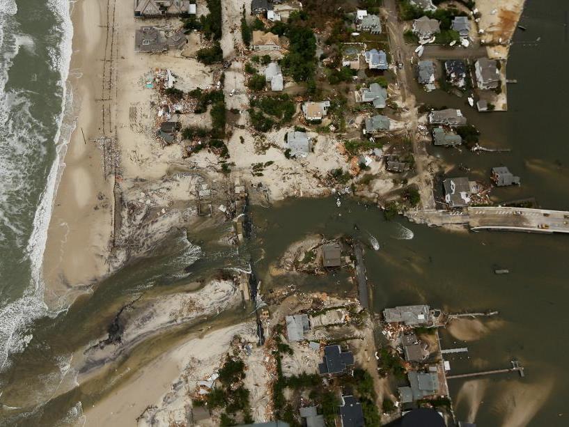
11 Superstorm Sandy

12

13

14

15

16

17
18

19

20

21

22

23

24
25 Flood Hazard Emergency Rules Emergency amendments on 1/24/13: Incorporated FEMA s Advisory Base Flood Elevations (ABFEs) and Work maps In tidal areas use BFE or ABFE, whichever is higher Work map supersedes ABFE Automatically incorporates any existing and future FEMA maps that show NJ design flood elevation
 Allows dry flood-proofing of non-residential buildings when elevating or wet flood-proofing when it is not practical to dry flood")
26 Flood Hazard Emergency Rules Revised permit-by-rule that allows building to be reconstructed, relocated and/or expanded by up to 300 ft 2 Revised building standards to match DCA and FEMA where possible (to eliminate conflicts) Allows dry flood-proofing of non-residential buildings when elevating or wet flood-proofing when it is not practical to dry flood proof

 Once adopted, they will become")
27 ABFEs Once FEMA completes their calculations, they will propose the maps through the Federal Register and have public meetings (a.k.a. preliminary maps) Once adopted, they will become effective The effective elevations will differ somewhat from the advisory elevations due to finalization of wave height analysis ADVISORY PRELIMINARY EFFECTIVE

28 FEMA flood mapping Effective Flood Insurance Rate Maps Preliminary Flood Insurance Rate Maps Source: FEMA

29 FEMA preliminary mapping is now available for all eastern/coastal counties in NJ, as well as portions of New York


30 Incorporating FEMA maps NJDEP is working with FEMA to remap the State s flood hazard areas People will easily see NJDEP & FEMA mapping online FEMA is putting NJDEP s design flood elevation on its maps
31 Incorporating FEMA maps If FEMA adopts a map showing NJDEP design flood elevation, it will automatically become a NJDEP map and replace any old flood maps FEMA recently adopted such mapping along the Delaware River in Hunterdon, Warren & Sussex Counties
32 Determining NJ design flood elevation In tidal areas DFE = FEMA 100-year flood Use FEMA effective map or preliminary map, whichever has the higher flood elevation
33 Coastal Emergency Rules Emergency amendments effective April 16, 2013 Facilitation of the expeditious rebuilding of residential and commercial developments Facilitation of renovation or reconstruction of existing marinas and construction of new marinas Restoration of New Jersey s shellfish industry Maintenance of engineered beaches and dunes and establishment of living shorelines Facilitation of removal of sand and other material from waterways
34 Rebuilding of residential and commercial developments Modified the permit-by-rule at N.J.A.C. 7:7-7.2(a)7 for reconstruction of residential or commercial development Allows for the reconstruction of damaged structures and must have been legally occupied in the most recent five year period In the same footprint In compliance with FHA rules

35
36 Rebuilding of residential and commercial developments Added a new permit-by-rule for the expansion or relocation (with or without expansion) of the footprint of a residential or commercial development landward or parallel to the mean high water line at N.J.A.C. 7:7-7.2(a)8 (similar to FHA PBR) No increase in the number of dwelling units or parking spaces or equivalent parking area 400 square feet

37
38 Rebuilding of structures over water Streamlined the permitting process through clarification of the Zane exemption In-place measured in three dimensions (length, width & height) Dock or pier over wetlands, low-profile bulkheads, or a building over wetlands or water In-place measured in two dimensions (length & width) Docks, piers, wharfs, not over wetlands and bulkheads except low profile (existing floating docks can be replaced with fixed docks; bulkheads can be rebuilt higher)
39 PBR for reconfiguration of docks at existing marinas Reconfiguration of any legally existing dock, wharf, or pier located at a legally existing marina, provided the marina is not located within shellfish habitat, submerged vegetation habitat, or a wetland Must stay within an existing Tidelands instrument No increase in the number of slips No increase in the total linear footage of docks or piers within the marina
40 PBR for the construction and/or installation of a pumpout facility The construction and/or installation of a pumpout facility or pumpout support facility shall have no adverse impacts to any special areas described at N.J.A.C. 7:7E-3. Rule allows for the construction of a sewer line connecting a pumpout facility and/or pumpout support facility into an existing sewer line located on-site or located immediately adjacent to the site
41 Construction of support facilities at legally existing and operating marinas Modified the coastal general permit at N.J.A.C. 7: for the construction of support facilities at legally existing and operating marinas Changed building(s) set backs from 100 to 15 feet from a shore protection structure or 25 feet from the mean high water line where no shore protection structures are present

42 Facilitation of renovation or reconstruction of existing marinas and construction of new marinas
43 Breakwater rule Modified the CZM rules at N.J.A.C. 7:7E (formerly breakwater general area rule) now called the vertical wake or wave attenuation structure rule, to focus on the protection of boat mooring areas and added flexibility in the type of structures
44 Establishment of living shorelines The amendments facilitate the establishment of living shorelines by modifying the coastal general permit at N.J.A.C. 7:7.29 for habitat creation and enhancement to include the establishment of living shorelines Modify the CZM rules for shellfish habitat, N.J.A.C. 7:7E-3.2; submerged vegetation habitat, N.J.A.C. 7:7E-3.6; intertidal subtidal shallows, N.J.A.C. 7:7E-3.15; wetlands, N.J.A.C. 7:7E-3.27; filling, N.J.A.C. 7:7E-4.11; coastal engineering, N.J.A.C. 7:7E-7.11; and marine fish and fisheries, N.J.A.C. 7:7E-8.2 to allow for the establishment of living shorelines Added a new general water area rule which sets forth standards for the establishment of living shorelines at N.J.A.C. 7:7E-4.23


45 Natural living shoreline Before After

46 hybrid

47 Hybrid living shoreline Rock used to slow water and allow for the build-up of sediment near the shore so vegetation can grow

48 hybrid

49
50 Removal of sand and other material Use an existing dredged material management areas Added a new permit-by-rule at N.J.A.C. 7:7-7.2(a)21 for the implementation of a sediment sampling plan in a water area as part of a dredging or dredged material management activity or as part of a remedial investigation of a contaminated site Encouraged the beneficial use of dredged material Added three new coastal general permits for: The dredging of sand from a man-made lagoon The dredging of material from a waterway at a residential or commercial development The dredging and management of material from a marina
51 Coastal Rule Proposal (transformation) Published: June 2, 2014 Download proposal at: Anticipate adoption: June 2, 2015

52 Transformation of land use rules Transform land use business process Set platform for electronic permit submission
53 Proposed Coastal Rules Goals Combine N.J.A.C. 7:7 & 7:7E into one chapter Align permit-processing standards with upcoming flood hazard area (FHA) & freshwater wetlands (FWW) rules Adopt 2 new permits-by-rule, 2 new general permits-bycertification, and 1 new general permit Amend 5 existing general permits Amend certain IP standards Amend dredging rules, allow for more beneficial reuse of dredge material Incorporate Dredging Technical Manual
54 Proposed Coastal Rules Amendments Aligns application review process with upcoming FHA and FWW rules: Emergency authorizations Pre-application conferences Application requirements Requirements for an applicant to provide public notice Application review Permit conditions and changes to issued permits Requests for adjudicatory hearings
55 Proposed Coastal Rules Amendments New mitigation subchapter Similar sections as anticipated changes to FHA and FWW rules All mitigation requirements are in one subchapter (SAV, ISS, Wetland, Shellfish, Riparian Zone) Incorporates banking Conservation restrictions Matches proposed FHA rules
56 Proposed Amendments New Subchapter for general provisions for PBR, Modification, GP s and IP s Content similar in both Coastal & FHA rules except for the duration of permit 5 year permit w/ a 5 year extension for GP s and IP s for activities occurring below MHWL in CR and GP & IP s in FHA rules Coastal IP s for activities above MHWL will keep commence and continue language based on stakeholder comments
57 Proposed Coastal Rules Two new permits-by-rule 1. Pesticide application in coastal wetlands to control invasive plant species For less than ¼ acre of disturbance Must be conducted in accordance with an NJDEP aquatic pesticide permit 2. Installation of a pool/spa on a bulkheaded lot
58 Proposed Coastal Rules Two general permits-by-certification Instant online application Applicant certifies each standard is met 1. Reconstruction of a legally existing functioning bulkhead in-place or upland of the existing bulkhead 2. Construction of piers, docks, pilings, and boatlifts in manmade lagoons

59 Proposed Coastal Rules New general permit Pesticide application in coastal wetlands to control invasive plant species For projects > ¼ acre Cannot affect T&E species or certain plants Must be conducted in accordance with an NJDEP aquatic pesticide permit
60 Proposed Coastal Rules Amended general permits GP for construction of a single-family or duplex dwelling is amended to apply to one or two single-family or duplex dwellings. GP for construction or reconstruction of bulkheads are amended to allow the beneficial use of the dredged material as fill and to modify the requirements for bulkheads constructed in V zones. GP for investigation, cleanup, removal, or remediation of hazardous substances and geotechnical soil borings are proposed to be amended to reflect changes to the Technical Requirements for Site Remediation, N.J.A.C. 7:26E, and the Department s organizational structure.
61 Proposed Coastal Rules Amended general permits GP for construction of piers, docks (including jet ski ramps), pilings, and boatlifts in man-made lagoons is proposed to be modified to allow for alternative design rather than the currently prescribed plank spacing requirements. GP for dredging and management of material from a marina deposited as a result of a storm event for which the Governor declared a State of Emergency is proposed to be amended to provide that the Department will make an acceptable use determination for the beneficial use of the dredged material.
62 Proposed Coastal Rules Other amendments Marinas Repealed existing N.J.A.C. 7:7E-7.3A Marina Development rule Relying on design standards laid out in the resort recreational use rule
63 Proposed Coastal Rules Other amendments Shellfish Special Area rule: Propose to allow for the expansion of an existing marina or construction of a new marina in limited infill situations in shellfish habitat Legally existing, operating commercial marinas that are open to the public for the mooring of vessels, including marinas operated by public agencies, commissions and authorities. The expansion must be designed and constructed in a manner that limits the area of shellfish habitat condemned and reduces impacts to marine ecosystem. Sufficient water depths to accommodate the vessel to be moored- at a minimum 2 feet at mean low water
64 Proposed Coastal Rules Other amendments Resort/Recreational Use rule: Allows for the construction of a restaurant at a new or existing marina facility provided: Marina facility supports 25 or more dockage units consisting of either dry dock storage or wet slips Existing marinas: the existing upland marina support facilities shall be preserved to the maximum extent practical such that the marina use on the site is not compromised New marinas: the facility includes the development of an appropriate mix of dry storage and berthing area and marina support facilities providing services such as showrooms, maintenance and repair, marine supplies, bait and tackle sales, boat sales and the dock master s office
65 Proposed Coastal Rules Other amendments Restaurant is located landward of the mean high water line Set back a minimum of 15 feet from a shore protection structure and 25 feet from the MHWL where no shore protection is present The marina facility provides onsite pumpout facilities and restrooms for marina and restaurant patrons. Public access must be provided
66 Proposed Coastal Rules Other amendments Dredging The definition of maintenance dredging is amended to provide flexibility in demonstrating that a proposed dredging activity qualifies as maintenance dredging. Amendments recognize environmental dredging, which is dredging to remove contaminated sediments from a waterbody for remediation purposes.
67 Proposed Coastal Rules Other amendments Dredging (cont.) A new special area rule addressing existing dredged material management areas is being proposed Recognition that these areas serve a critical function as management areas for sediments removed from existing navigation channels and marinas to maintain recreational and commercial boating and marine commerce in the State s waters Portions of the Department's dredging technical manual are incorporated in the CZM rules as a regulatory appendix
68 Proposed Coastal Rules Other amendments Recreational docks and piers rule Modified the spacing requirements to allow alternative dock design that would allow for equal or greater sunlight penetration as docks constructed of planking and configured as prescribed. Includes grate decking which is constructed of metal, wood, aluminum or similar materials which allow sunlight penetration through the grates.
69 Getting Back to Transformation Flood Hazard rules File: March 2015 Publish: April/May 2015 Adoption: Fall 2015
70 FHA Anticipated Amendments 1. Delete special water resource protection area from stormwater management rule No more Functional Value Analysis No reliance on USGS maps or soil surveys to determine location of SWRPA No prohibition on development within inner 150 Rule will rely on riparian zone requirements for determining allowable disturbance
71 FHA Anticipated Amendments 2. Delete prohibition on stormwater discharges within 150 & 300 riparian zone Water quality design storm must be infiltrated outside the RZ where possible Where not possible, require 95% TSS removal for discharges within 300 riparian zone Allow discharges directly into surface waters This will address significant concerns raised by SCD regarding erosion at discharges
72 FHA Anticipated Amendments 3. Add flexibility to riparian zone standards Increase allowable area of RZ disturbance Remove hardship exception requirement if limits under an IP are exceeded Add flexibility for projects in actively disturbed areas (lawns, meadows, agricultural fields) Remove setback requirement along impounded fluvial waters and tidal waters, where the bank has a bulkhead or revetment
73 FHA Anticipated Amendments 4. Incorporate riparian zone clarifications Clarify what a top of bank is and how to determine its location Clarify that temporary disturbance to actively disturbed areas does not count against overall RZ disturbance limits Clarify that there are no limits to disturbance of areas occupied by structures
74 FHA Anticipated Amendments 4. Riparian zone clarifications (cont.) Clarify what can and cannot be built within 25 feet of top of bank Clarify that piped streams do not have a RZ Clarify that the RZ arcs at end of a stream, but not at a pipe entrance

75 FHA Anticipated Amendments 5. Total of 13 general permits
")
76 FHA Anticipated Amendments 5. General permits (cont.)

77 FHA Anticipated Amendments 6. Total of 15 general permits-by-certification

78 FHA Anticipated Amendments 6. General permits-by-certification (cont.)

79 FHA Anticipated Amendments 6. General permits-by-certification (cont.)
80 FHA Anticipated Amendments 7. Expand/clarify/combine 47 existing permits-byrule and increase to a total of 63 permits-by-rule Solar panels In-kind replacement of certain culverts ROW maintenance Docks & piers Handicap ramps/access Repairing septic systems Monitoring wells and soils borings Invasive vegetation removal & enhancement activities Forestry activities approved under a forestry management plan Variable message signs, light poles, etc.
81 FHA Anticipated Amendments 8. Provide additional riparian zone mitigation options Creation: day-lighting streams (removing structures that enclose a stream, such as a culvert) Restoration: removing structures and planting trees Enhancement: planting trees to upgrade ecologic benefits of area devoid of trees Preservation: placing a conservation easement on forested land Banking: credit system, like FWW rules, for riparian zones planted with trees
82 FHA Anticipated Amendments 9. Align administrative procedures with FWW & Coastal rules Definitions Contact information General provisions for PBRs and General permits Mitigation Conservation restrictions Emergency authorizations Pre-application conferences Application requirements Public notice Application review Permit conditions The modification, transfer, suspension and termination of approvals Requests for adjudicatory hearings Enforcement provisions
83 Questions?
New Jersey Department of Environmental Protection
 New Jersey Department of Environmental Protection Assistant Commissioner Marilyn Lennon Land Use Management Division of Land Use Regulation Manager Virginia Kopkash September 16, 2013 Transformation of
KRISTOPHER J. KRZYSTON, CEI, CEM
 PERMITTING IN NEW JERSEY KRISTOPHER J. KRZYSTON, CEI, CEM Kristopher J. Krzyston Rutgers graduate 1994 B.S. Environmental Planning Certificate in G.I.S. Assistant Division Manager Environmental Science
CHAPTER 6 ADDITIONAL STANDARDS APPLYING TO SHORELAND AREAS AND PUBLIC WATERS
 CHAPTER 6 ADDITIONAL STANDARDS APPLYING TO SHORELAND AREAS AND PUBLIC WATERS Section 1 Intent. 49 Section 2 Floodplain Requirements 49 Section 3 Water-Oriented Accessory Structures 50 Section 4 Stairways,
CONSERVATION & COASTAL MANAGEMENT
 CONSERVATION & COASTAL MANAGEMENT City of St. Augustine Comprehensive Plan EAR-Based Amendments Conservation and Coastal Management Element Conservation Goal Protect and conserve natural areas, environmentally
PENDER HARBOUR DOCK MANAGEMENT PLAN
 PENDER HARBOUR DOCK MANAGEMENT PLAN 1.0 INTENT OF DOCK MANAGEMENT PLAN The Pender Harbour Dock Management Plan (the DMP) is an instrument of policy that provides guidance in relation to docks authorized
15A NCAC 07H.0209 COASTAL SHORELINES (a) Description. The Coastal Shorelines category includes estuarine shorelines and public trust shorelines.
 Description. The Coastal Shorelines category includes estuarine shorelines and public trust shorelines.") 15A NCAC 07H.0209 COASTAL SHORELINES (a) Description. The Coastal Shorelines category includes estuarine shorelines and public trust shorelines. Estuarine shorelines AEC are those non-ocean shorelines
15A NCAC 07H.0209 COASTAL SHORELINES (a) Description. The Coastal Shorelines category includes estuarine shorelines and public trust shorelines. Estuarine shorelines AEC are those non-ocean shorelines
Definitions. Currently serviceable: Useable as is or with some maintenance, but not so Degraded as to essentially require reconstruction.
 Definitions Best management practices (BMPs): Policies, practices, procedures, or structures implemented to mitigate the adverse environmental effects on surface water quality resulting from development.
ENVIRONMENTAL RESOURCE PERMIT APPLICATION
 ENVIRONMENTAL RESOURCE PERMIT APPLICATION SOUTHWEST FLORIDA WATER MANAGEMENT DISTRICT 2379 BROAD STREET, BROOKSVILLE, FL 34604-6899 (352) 796-7211 OR FLORIDA WATS 1 (800) 423-1476 SECTION E INFORMATION
Current Trends in Marina Planning and Design
 ASSOCIATION OF PACIFIC PORTS 101 st Annual Conference, July 2014 Current Trends in Marina Planning and Design, PE, LEED AP, Reid Middleton Outline Introduction Market & Demand Planning Environmental Design
New Castle County, DE. Floodplain Regulations
 New Castle County, DE Floodplain Regulations John J. Gysling, PE CFM Department of Land Use New Castle County, DE February 26, 2009 Today s Presentation Floodplain Protection and Uses Terms and Definitions
SHORELINE STABILIZATION AND MARINE FACILITIES PUBLIC WORKSHOP. Town of Jupiter Community Center February 12, :30 PM
 SHORELINE STABILIZATION AND MARINE FACILITIES PUBLIC WORKSHOP Town of Jupiter Community Center February 12, 2015 5:30 PM We are here to Discuss new options and flexibility with regard to marine facilities
Conditions of Section 401 Certification for Nationwide Permits and General Conditions. General Condition 12 (Soil Erosion and Sediment Controls)
") Conditions of Section 401 Certification for Nationwide Permits and General Conditions General Condition 12 (Soil Erosion and Sediment Controls) Erosion control and sediment control BMPs described in Attachment
Conditions of Section 401 Certification for Nationwide Permits and General Conditions General Condition 12 (Soil Erosion and Sediment Controls) Erosion control and sediment control BMPs described in Attachment
Department of the Army Permit Application
 Department of the Army Permit Application DA File Number U.S. Army Corps of Engineers Honolulu District Date Received by CEPOH-RO Send Completed Application to: Honolulu District, U.S. Army Corps of Engineers
dpd Seattle Permits CAM Environmentally Critical Areas: Wetlands and Fish & Wildlife Habitat Conservation Areas
 dpd Department of Planning and Seattle Permits CAM Client Assistance Memo 326 part of a multi-departmental City of Seattle series on getting a permit Environmentally Critical Areas: Wetlands and Fish &
2. Does not require, involve or include any additions to, or repair or modification of, the existing foundation.
 SECTION 3109 STRUCTURES SEAWARD OF A COASTAL CONSTRUCTION CONTROL LINE 3109.1 General. The provisions of this section shall apply to the design and construction of habitable structures, and substantial
U.S. Army Corps of Engineers Water Resources Regulatory Program: Emergency Stream Restoration
 U.S. Army Corps of Engineers Water Resources Regulatory Program: Emergency Stream Restoration Margaret Crawford Biologist Auburn Field Office June 3, 2014 US Army Corps of Engineers Section 10 of the Rivers
5.5 NAVIGABLE WATERWAYS AND COASTAL ZONE
 5.5 NAVIGABLE WATERWAYS AND COASTAL ZONE This section discusses the effect of the Proposed Action on navigable waterways, and the Proposed Action s consistency with coastal zone policies. 5.5.1 Navigable
These guidelines are to ensure systematic and consistent pier construction throughout the Jonathan s Landing development.
 PIER GUIDELINES 1 PIER CONSTRUCTION GUIDELINES These guidelines are to ensure systematic and consistent pier construction throughout the Jonathan s Landing development. 1. DEFINITIONS The following definitions
NJDEP Regulations that impact or soon will impact agricultural operations. April 1, 2007 Horses 2007
 NJDEP Regulations that impact or soon will impact agricultural operations. April 1, 2007 Horses 2007 Peter L. Kallin, Ph.D., P.W.S. Phone: 732-499-3600 Ext. 237 E-mail: pkallin@aesop.rutgers.edu www.water.rutgers.edu
STATE OF WASHINGTON FINAL DECISIONS AND SECTION 401 WATER QUALITY CERTIFICATION CONDITIONS FOR THE CORPS OF ENGINEERS 2017 NATIONWIDE PERMIT PROGRAM
 STATE OF WASHINGTON FINAL DECISIONS AND SECTION 401 WATER QUALITY CERTIFICATION CONDITIONS FOR THE CORPS OF ENGINEERS 2017 NATIONWIDE PERMIT PROGRAM In addition to all the U.S. Army Corps of Engineers
I202. Central Wharves Precinct
 I202. Central Wharves Precinct I202.1. Precinct description The zoning of the land within the Central Wharves Precinct is the Business City Centre Zone and the underlying zoning of the part of the Central
Ordinance No Lot Surface Drainage
 Ordinance No. 35-2008 - Lot Surface Drainage The Township has adopted a new Lot Surface Drainage Ordinance which amends Chapter 170, Article IX, Subdivision and Site Plan Review by adding a new Section
City of Sanibel. Planning Department STAFF REPORT. City of Sanibel Planning Commission Land Development Code Review Subcommittee
 City of Sanibel Planning Department STAFF REPORT City of Sanibel Planning Commission Land Development Code Review Subcommittee Committee Meeting Date: April 22, 2014 Agenda Item: 3a. RE: Floating docks,
Fiscal & Regulatory Impact Analysis
 Fiscal & Regulatory Impact Analysis Excavation of Upland Basins Amendments to 15A NCAC 7H.1501 &.1505 General Permit for Excavation within or Connecting to Existing Canals, Channels, Basins or Ditches
Municipal Stormwater Management Planning
 Municipal Stormwater Management Planning Christopher C. Obropta, Ph.D., P.E. Water Resources Extension Specialist with Rutgers Cooperative Extension Assistant Professor with Department of Environmental
CHAPTER 62B-34 GENERAL PERMITS FOR ACTIVITIES SEAWARD OF THE COASTAL CONSTRUCTION CONTROL LINE
 1 2 CHAPTER 62B-34 GENERAL PERMITS FOR ACTIVITIES SEAWARD OF THE COASTAL CONSTRUCTION CONTROL LINE 3 4 5 6 7 8 9 10 11 12 13 14 15 62B-34.010 62B-34.030 62B-34.040 62B-34.050 62B-34.055 62B-34.060 62B-34.070
Overview of National and State erosion management reviews & reports
 Overview of National and State erosion management reviews & reports National Research Council: Managing Coastal Erosion 1990 Heinz Center: Evaluation of Erosion Hazards 2000 Maryland: Shore Erosion Task
(For individual lake and stream classifications in Cook County, refer to Appendix II)
") Article 7 Sec. 7.01 Shoreland Management Regulations Policy The uncontrolled use of shorelands of Cook County, Minnesota affects the public health, safety and general welfare not only by contributing to
Article 7 Sec. 7.01 Shoreland Management Regulations Policy The uncontrolled use of shorelands of Cook County, Minnesota affects the public health, safety and general welfare not only by contributing to
STREAM AND BUFFER AREA PROTECTION/RESTORATION
 STREAM AND BUFFER AREA PROTECTION/RESTORATION AMENDMENT OPTIONS TO STRENGTHEN POLICY IN HEADWATERS AREAS DRAFT SUBSEQUENT TO THE JANUARY 25, 2007 MEETING OF THE PLANNING COMMISSION ENVIRONMENT COMMITTEE
EROSION, SEDIMENTATION, ETC
 EROSION, SEDIMENTATION, ETC. 19-61 ARTICLE V. WATER QUALITY REVIEW IN SPECIAL PROTECTION AREAS. Sec. 19-60. Findings and purpose. (a) The County Council finds that streams, rivers, wetlands, and other
TOWN OF HARRISON SHORELAND ZONING ORDINANCE $3.00. Adopted June 30, 1992
 TOWN OF HARRISON SHORELAND ZONING ORDINANCE $3.00 Adopted June 30, 1992 Amended June 19, 1993 Amended June 12, 1996 Amended June 9, 1999 Amended June 13, 2002 Amended September 21, 2004 Amended June 15,
FORT MYERS BEACH LAND DEVELOPMENT CODE
 FORT MYERS BEACH LAND DEVELOPMENT CODE CHAPTER 26 MARINE FACILITIES 1 Sec. 26-82. Dredging, new and maintenance. Secs. 26-83--26-110. Reserved. ARTICLE III. MARINE SANITATION ARTICLE I. IN GENERAL Sec.
Fish and Wildlife Habitat Conservation Areas
 Thurston County planning Department BOARD OF COUNTY COMMISSIONERS PUBLIC HEARING DRAFT AMENDMENTS TO THE CRITICAL AREAS REGULATIONS Changes From Planning Commission Recommendation Chapter 24.25 6/4/2012
E36. Natural hazards and flooding
 E36. Natural hazards and flooding E36.1. Background Auckland is affected by natural hazards including: those that occur frequently such as flooding, coastal erosion (including the effects of sea level
SECTION 11: REGULATORY FLOODWAYS
 SECTION 11: REGULATORY FLOODWAYS Contents 11.1. The Floodway... 11-2 11.1.1. The floodway concept... 11-2 11.1.2. Floodway map... 11-2 11.1.3. Floodway permitting... 11-3 11.1.4. Changing the floodway...
CHAPTER 7. San Dieguito River Flooding Adaptation
 CHAPTER 7 San Dieguito River Flooding Adaptation This chapter includes a range of adaptation measures to address vulnerabilities from flooding along the San Dieguito River, including the river valley,
U.S. Army Corps of Engineers Permit Application Tips
 U.S. Army Corps of Engineers Permit Application Tips MnDOT Environmental Conference Ben Orne and Sarah Wingert, USACE 4-29-2015 US Army Corps of Engineers BUILDING STRONG Outline Introduction to Corps
CITY OF SPRING HILL Water Quality Buffer Zone Policy (Adopted April 22, 2008)
") Section I - Description CITY OF SPRING HILL Water Quality Buffer Zone Policy (Adopted April 22, 2008) A water quality buffer zone (a.k.a. a riparian zone) is a strip of undisturbed native (indigenous)
Section I - Description CITY OF SPRING HILL Water Quality Buffer Zone Policy (Adopted April 22, 2008) A water quality buffer zone (a.k.a. a riparian zone) is a strip of undisturbed native (indigenous)
A Guide to Project Review
 A Guide to Project Review Updated March 2015 Vancouver Fraser Port Authority, doing business as Port Metro Vancouver, has prepared this guide to assist tenants, terminal operators, consulting firms and
E36. Natural hazards and flooding
 E36. Natural hazards and flooding E36.1. Background Auckland is affected by natural hazards including: those that occur frequently such as flooding, coastal erosion (including the effects of sea level
Clallam County Shoreline Master Program (SMP) Update
 Update") Title Level 1 Title Level 2 Clallam County Shoreline Master Program (SMP) Update Port Angeles Public Forum November 8, 2017 Clallam County Shoreline Master Program: In effect for Over 40 years, with nine
Title Level 1 Title Level 2 Clallam County Shoreline Master Program (SMP) Update Port Angeles Public Forum November 8, 2017 Clallam County Shoreline Master Program: In effect for Over 40 years, with nine
Chapter 4 Policies and Regulations for Shoreline Modifications
 Chapter 4 Policies and Regulations for Shoreline Modifications 4.1 Beach Access Structures 4.1.0 Applicability Beach Access Structures, as defined in Chapter 11, shall be consistent with the following
Currituck County Pier, Dock & Bulkhead Handout
 Currituck County Pier, Dock & Bulkhead Handout Definitions: ACCESSORY STRUCTURE. An accessory structure is any structure not roofed over and enclosed more than 50% of its perimeter walls, located on one-
Chapter 516 Shoreland Districts
 Chapter 516 Shoreland Districts 516.01 Statutory Authorization The State of Minnesota in Minnesota Statutes, Chapter 103F, has defined shoreland areas and described limitations on uses and locations of
State of Florida Department of Community Affairs Areas of Critical State Concern Implementation Status Report Apalachicola Bay Area
 State of Florida Department of Community Affairs Areas of Critical State Concern Implementation Status Report Apalachicola Bay Area Thaddeus L. Cohen, AIA Secretary November 2006 CONTENTS Part 1 - Summary
PUBLIC NOTICE LOS ANGELES DISTRICT. APPLICATION FOR PERMIT Port of Los Angeles Berths : Wilmington Waterfront Promenade
 PUBLIC NOTICE U.S. ARMY CORPS OF ENGINEERS LOS ANGELES DISTRICT BUILDING STRONG APPLICATION FOR PERMIT Port of Los Angeles Berths 182-186: Wilmington Waterfront Promenade Public Notice/Application No.:
RIPARIAN PROTECTION Questions & Answers
 RIPARIAN PROTECTION Questions & Answers 1. What is a riparian corridor and why is it important? Answer: A riparian corridor is a space on both sides of a stream or around a lake or wetland. The corridor
Old Mill School Stream Restoration
 Project Overview This conceptual plan restores and stabilizes two consecutive reaches of a highly incised and unstable stream and reconnects them with the floodplain. The restoration reaches are part of
Holly Swartz and Jason Shirey
 Chapter 105 General Permits for Stream and Wetland Impacts DEP Ch. 105 CONTACTS FOR BERKS COUNTY: Holly Swartz and Jason Shirey What DEP Regulates Under Chapter 105 Waters of the Commonwealth, which includes
Maryland s Living Shorelines Program. Bhaskaran Subramanian February 27, 2015
 Maryland s Living Shorelines Program Bhaskaran Subramanian February 27, 2015 1 Erosion & traditional approaches Living shorelines- what is it? Maryland s Living Shorelines program LS Law Products Funding-
STORMWATER RUNOFF AND WATER QUALITY IMPACT REVIEW
 SUBCHAPTER 8 STORMWATER RUNOFF AND WATER QUALITY IMPACT REVIEW 7:45-8.1 Purpose and scope of review Except for those projects expressly exempted by this chapter or waived by the Commission, the Commission
Regulatory Reform at MassDEP and Amendments to the Wetlands Protection Act. AMWS Conference November 16, 2012
 Regulatory Reform at MassDEP and Amendments to the Wetlands Protection Act AMWS Conference November 16, 2012 Background MassDEP 2002 MassDEP 2011 State budget cuts begin MassDEP budget significantly reduce
Environmental Protection (NJDEP) The Louis Berger Group, Inc.
 The Louis Berger Group, Inc.") Hydraulic Modeling for Preliminary Evaluation of Potential Flooding Impacts for Various Dredging, Capping and Armoring Scenarios of The Lower Passaic River Restoration Abdulai Fofanah, PE, D.WRE, CFM Murat
Hydraulic Modeling for Preliminary Evaluation of Potential Flooding Impacts for Various Dredging, Capping and Armoring Scenarios of The Lower Passaic River Restoration Abdulai Fofanah, PE, D.WRE, CFM Murat
Shoreline Master Program VISIONING OVERVIEW
 Shoreline Master Program VISIONING OVERVIEW DATE: December 5, 2012 TO: FROM: City of Kalama Panning Commission David Sherrard, Parametrix, Project Manager Jennifer Hughes, Parametrix, Planner SUBJECT:
Environmental Assessment Appendix G: Coastal Zone Consistency. U.S. Army Corps of Engineers New York District
 Environmental Assessment Appendix G: Coastal Zone Consistency U.S. Army Corps of Engineers New York District January 2004 Environmental Assessment Appendix G1: New York State Coastal Zone Management Policies
Instructions for Notice of Ground Disturbance Form:
 Instructions for Notice of Ground Disturbance Form: Prior to beginning any ground disturbance activity or finalizing your storm water plan, submit a completed 2 page Notice of Ground Disturbance Form to
Appendix H: Construction Impacts H-5 Dredged Materials Management Alternatives Analysis
 Appendix H: Construction Impacts H-5 Dredged Materials Management Alternatives Analysis Dredged Material Management Alternatives Analysis A. INTRODUCTION The Tappan Zee Hudson River Crossing Project proposes
E1. Water quality and integrated management
 E1. Water quality and integrated management E1.1. Introduction The National Policy Statement for Freshwater Management, the New Zealand Coastal Policy Statement and this Plan seek to improve the integrated
Chapter 105 Dam Safety and Waterway Management
 Chapter 105 Dam Safety and Waterway Management An overview PA Department of Environmental Protection Bureau of Watershed Management Division of Waterways, Wetlands, & Stormwater Management Purpose The
CHAPTER IV. RESOURCE PROTECTION STANDARDS
 CHAPTER IV. RESOURCE PROTECTION STANDARDS 4.00.00. OVERALL PURPOSE AND INTENT The purpose of this chapter is to protect, conserve and enhance Walton County's natural features. It is the intent of the County
Standards for SWMF s. (Stormwater Management Facilities) Lacombe County s Guide to Developing Stormwater Management Facilities
 Lacombe County s Guide to Developing Stormwater Management Facilities") Standards for SWMF s (Stormwater Management Facilities) Lacombe County s Guide to Developing Stormwater Management Facilities August 2017 PREAMBLE Development results in a great amount of impervious area,
Standards for SWMF s (Stormwater Management Facilities) Lacombe County s Guide to Developing Stormwater Management Facilities August 2017 PREAMBLE Development results in a great amount of impervious area,
Sustainable Natural Environment Fish Habitat
 Town of Huntsville Official Plan Review - POLICY BACKGROUND PAPER Sustainable Natural Environment Fish Habitat BACKGROUND: Lakes, rivers, streams, ponds and many wetlands provide fish habitat. Intermittent
POLICY FOR NATURAL RESOURCE MANAGEMENT AREAS
 POLICY FOR NATURAL RESOURCE MANAGEMENT AREAS I. POLICY STATEMENT Auburn University's (the University's) "Policy for Natural Resource Management Areas" implements the Campus Master Plan Land Use Element
Chapter 11. A Regulatory Framework for Shoreline Structures. Summary of Issues and Recommendations
 Chapter 11. Summary of Issues and Recommendations The Massachusetts Waterways (Chapter 91) Regulations (310 CMR 9.32 (1)) prohibit the licensing of new, non-commercial structures (i.e., private docks and
Section Treatment of Sewage and Stormwater
 Section 300.6. Treatment of Sewage and Stormwater A. Definitions 1. Sewage: The Council has adopted the definition of sewage set forth under Title 46, Chapter 12, Section 1 or the General Laws, to wit:
CORPS REGULATORY PROGRAM
 CORPS REGULATORY PROGRAM Emily Hughes Special Projects Manager/Outreach Specialist Wilmington Regulatory Field Office USACE, Wilmington District US Army Corps of Engineers BUILDING STRONG Corps Regulatory
U.S. Army Corps of Engineers
 U.S. Army Corps of Engineers New England District General Permits for Massachusetts Greg Penta, Policy, Analysis & Technical Support Branch Paul Sneeringer, MA Permitting & Enforcement Branch April 2015
Review Zone Application for D&R Canal Commission Decision
 Review Zone Application for D&R Canal Commission Decision MEETING DATE: December 21, 2016 DRCC #: 16-4345 Latest Submission Received: December 7, 2016 Applicant: Robert McCarthy, PE PSE&G 4000 Hadley Road,
Joint Public Notice. LOCATION: In Salmon Bay, Lake Washington Ship Canal, at Seattle, Washington.
 US Army Corps of Engineers Seattle District Joint Public Notice Application for a Department of the Army Permit and a Washington Department of Ecology Water Quality Certification and/or Coastal Zone Management
Living Shorelines. In this issue... What is a living shoreline?
 In this issue... We focus on an approach to shoreline management known as living shoreline designs. These strategies for managing erosion while preserving ecological services are increasingly viewed as
Understanding and Evaluating Erosion Problems
 Understanding and Evaluating Erosion Problems Fast Current Slow Current Transport Sally Russell Cox Alaska Division of Community and Regional Affairs (DCRA) October 22, 2014 Helps Alaskan communities and
Memorandum. California public trust law governs the administration of tidelands and submerged lands in several ways:
 Memorandum To: Piers 30-32 Citizen s Advisory Committee ( CAC ) Land Use Subcommittee From: Brad Benson and Diane Oshima Date: January 10, 2013 Re: Public Trust Doctrine and BCDC The purpose of this memo
UNIVERSITY OF OREGON NORTH CAMPUS CONDITIONAL USE PERMIT PROJECT Draft Conditional Use Permit Stormwater, Sanitary Sewer, and Water Analysis Report
 UNIVERSITY OF OREGON NORTH CAMPUS CONDITIONAL USE PERMIT PROJECT Draft Conditional Use Permit Stormwater, Sanitary Sewer, and Water Analysis Report Prepared for: Cameron McCarthy Landscape Architects LLP
Final Design Guideline
 Final Design Guideline May, 2016 July, 2011 Check the Capital Project Delivery website to ensure this is the current version Table of Contents Purpose... 1 Introduction... 1 FD Support... 1 Roadway and
DRAINAGE AND NATURAL AQUIFER GROUNDWATER RECHARGE ELEMENT
 Goal 7.0. To optimize integrated stormwater management in order to reduce damage and impacts from sea level rise and flooding, promotes recharge to the Surficial Aquifer System (SAS), improve and protect
Distribution Restriction Statement Approved for public release; distribution is unlimited.
 CECW-EH-D Regulation No. 1110-2-1404 Department of the Army U.S. Army Corps of Engineers Washington, DC 20314-1000 Engineering and Design HYDRAULIC DESIGN OF DEEP-DRAFT NAVIGATION PROJECTS Distribution
Natural Resources Protection Act and 35-A M.R.S.A
 Maine State Library Maine State Documents Land and Water Quality Documents Environmental Protection 6-2015 Natural Resources Protection Act and 35-A M.R.S.A. 3452 2015 Maine Bureau of Land and Water Quality
Kootenai County Building & Planning Department
 Kootenai County Building & Planning Department Site Disturbance Ordinance Amendment Proposal STAFF DRAFT 12 11-2-4: DEFINITIONS: MECHANICAL GROUND DISTURBANCE: The use of mechanized and/or mechanically
Nationwide Permit General Conditions
 Nationwide Permit General Conditions Note: To qualify for NWP authorization, the prospective permittee must comply with the following general conditions, as applicable, in addition to any regional or case-specific
Section 1 Non-Conforming Structures and Uses Allowed to Continue. 12
 CHAPTER 3 NONCONFORMITIES Section 1 Non-Conforming Structures and Uses Allowed to Continue. 12 Section 2 Discontinuance 12 Section 3 Change of Use... 12 Section 4 Residential Alterations 12 Section 5 Restoration..
Surface Water and Non-Wetland Surface Waters Delineation and Classification pursuant Chapter F.A.C.
 Surface Water and Non-Wetland Surface Waters Delineation and Classification pursuant Chapter 62-340 F.A.C. What are Waters? 373.019 F.S. Definitions (20) Water or waters in the state means any and all
When the land division tree preservation requirements apply
 INFORMATION GUIDE Tree Preservation on Your Land Division Site The land division process provides the flexibility and opportunity to promote creative site design that considers multiple objectives, including
PLANNED UNIT DEVELOPMENT, PLANNING APPROVAL & SUBDIVISION STAFF REPORT Date: June 4, 2015
 PLANNED UNIT DEVELOPMENT, PLANNING APPROVAL & SUBDIVISION STAFF REPORT Date: June 4, 2015 NAME SUBDIVISION NAME CC Williams Plant Subdivision CC Williams Plant Subdivision LOCATION CITY COUNCIL DISTRICT
J O I N T P U B L I C N O T I C E
 J O I N T P U B L I C N O T I C E CHARLESTON DISTRICT, CORPS OF ENGINEERS 1949 Industrial Park Road, Room 140 Conway, South Carolina 29526 and THE S.C. DEPARTMENT OF HEALTH AND ENVIRONMENTAL CONTROL Office
Public Notice: Wetland/Waterway/Water Quality Regulations
 Public Notice: Wetland/Waterway/Water Quality Regulations Pursuant to M.G.L. c.30a, the MA Department of Environmental Protection (DEP) gives notice of its intent to revise the following regulations under
Commercial Shellfish Aquaculture in the Inland Bays
 Commercial Shellfish Aquaculture in the Inland Bays What is Aquaculture? Aquaculture: the husbandry or controlled cultivation of aquatic plants and animals Husbandry Controlled Aquatic - application of
PUBLIC NOTICE US Army Corps of Engineers, Honolulu District
 PUBLIC NOTICE US Army Corps of Engineers, Honolulu District Regulatory Office (CEPOH-RO) Public Notice Date: March 16, 218 Building 23 Expiration Date: March 3, 218 Fort Shafter, Hawaii 9688-44 Permit
Berth 9 Quay Extension Environmental Statement Non-Technical Summary
 Berth 9 Quay Extension Hutchison Ports UK Ltd July 2013 Final Report 9Y0150 CONTENTS Page 1 PROJECT BACKGROUND 1 2 NEED FOR THE PROPOSED SCHEME 4 3 DESCRIPTION OF THE CONSTRUCTION PHASE 4 4 DESCRIPTION
PLANNING COMMISSION STAFF REPORT. Utah Crew Rowing Dock Conditional Use 830 S. Delong Street September 8, 2010 Petition #PLNPCM
 PLANNING COMMISSION STAFF REPORT Utah Crew Rowing Dock Conditional Use 830 S. Delong Street September 8, 2010 Petition #PLNPCM2010-00449 Planning Division Department of Community and Economic Development
February 28, Re: N.J.A.C. 7:8 Stormwater Management Rules. Dear Commissioner Martin:
 Pinelands Preservation Alliance, American Littoral Society, Clean Ocean Action, New Jersey Environmental Federation, New Jersey Conservation Foundation, Princeton Hydro, Delaware Riverkeeper Network, Association
I. GENERAL INFORMATION
 STAFF REPORT BARROS VIOLATION RESOLUTION TO: Douglas County Hearing Examiner FROM: Douglas County Land Services Staff RE:, SP-16-05 DATE: November 7,2016 I. GENERAL INFORMATION Requested Action: An application
Chapter 3 Dispersion BMPs
 Chapter 3 Dispersion BMPs 3.1 BMP L611 Concentrated Flow Dispersion 3.1.1 Purpose and Definition Dispersion of concentrated flows from driveways or other pavement through a vegetated pervious area attenuates
Coastal Resource Management Planning
 College of William and Mary W&M Publish Reports Spring 2011 Coastal Resource Management Planning Center for Coastal Resources Management, Virginia Institute of Marine Science Follow this and additional
WATER SURFACE MANAGEMENT
 WATER SURFACE MANAGEMENT SAFETY STANDARDS FOR RESIDENTIAL DOCKS ON THE HIGHLAND LAKES LAKE BUCHANAN INKS LAKE LAKE LBJ LAKE MARBLE FALLS LAKE TRAVIS SAFETY STANDARDS FOR RESIDENTIAL DOCKS ON THE HIGHLAND
VEGETATIVE, WATER, FISH AND WILDLIFE RESOURCES POLICIES
 VEGETATIVE, WATER, FISH AND WILDLIFE RESOURCES POLICIES The County will: GOALS AND OBJECTIVES 1.1 Conserve, Enhance, Protect, Maintain and Manage Vegetative, Water, Fish and Wildlife Resources Promote
APPENDIX F. SECTION 404(B)(1) EVALUATION SHORT VERSION. Herbert Hoover Dike Dam Safety Modification Study
(1) EVALUATION SHORT VERSION. Herbert Hoover Dike Dam Safety Modification Study") Appendix F Section 404(b)(1) APPENDI F. SECTION 404(B)(1) EVALUATION SHORT VERSION Herbert Hoover Dike Dam Safety Modification Study HHD Dam Safety Modification Study EIS June 2016 E i Appendix F Section
Appendix F Section 404(b)(1) APPENDI F. SECTION 404(B)(1) EVALUATION SHORT VERSION Herbert Hoover Dike Dam Safety Modification Study HHD Dam Safety Modification Study EIS June 2016 E i Appendix F Section
WETLANDS AND OPEN WATERS Compensatory Mitigation Definitions of Factors
 Adverse effects as used in this section of the SOP means any adverse ecological effect on wetlands or areas of open water. Those effects, or impacts, include filling, excavating, flooding, draining, clearing,
ALTERNATIVES ANALYSIS LBC SHIP DOCK 5 PROJECT SWG HARRIS COUNTIES, TEXAS
 ALTERNATIVES ANALYSIS LBC SHIP DOCK 5 PROJECT SWG-2016-00832 HARRIS COUNTIES, TEXAS Prepared for: LBC Houston, LP 11666 Port Road Seabrook, Texas 77589 Prepared by: Lloyd Engineering, Inc. 6565 West Loop
Panama City Marina City of Panama City, Florida
 Panama City Marina City of Panama City, Florida MARINA BULKHEAD ASSESSMENT October 3, 2011 Prepared For: Prepared By: 543 Harbor Boulevard, Suite 204 Destin, Florida 32541 DRAFT - 12/19/2011 Panama City