SWAP Risk Informed Methods for Stormwater Assessment and Prioritization
|
|
|
- Mercy Garrison
- 5 years ago
- Views:
Transcription


1 SWAP Risk Informed Methods for Stormwater Assessment and Prioritization Sara Hillegas Woida, Hydraulic Engineer US Army Corps of Engineers, Pittsburgh Thomas Maier, Biologist/Planner US Army Corps of Engineers, Pittsburgh March 2017 US Army Corps of Engineers
2 Topics Study purpose & pilot projects Field reconnaissance & data collection Hydrologic & hydraulic analysis Prioritizing sites putting the tool to use Lessons Learned Challenges & Opportunities 2
3 Study Purpose Partnership with the Southwestern Pennsylvania Commission (SPC) Planning Assistance to States (PAS) Pgm USACE Pittsburgh District GOALS: 1. GIS inventory, field survey, analyze municipal stormwater infrastructure (culverts, small bridges) 2. Prioritize areas for future flood response and infrastructure management 3. Extend the methodology to other regional entities 3
4 Pilot Projects Elizabeth Township, Allegheny County 15 miles southeast of Pittsburgh, between Monongahela and Youghiogheny rivers 59 potential sites 30 sites met pilot study guidelines, with a total of 40 culverts Burrell Township, Indiana County 40 miles east of Pittsburgh, between the Conemaugh River and Blacklick Creek 78 potential sites 36 sites met pilot study guidelines, with a total of 38 culverts Both pilot project sites have experienced significant damages from recent flash flood events Increasing frequency and intensity of rainfall events in the future?(ref: 2017 ORB Climate Change Study) 4

5 Pilot Projects 5
6 Field Reconnaissance GIS Inventory Local Asset Management (LAM) sites Potential locations (NHD + street layer) Field Reconnaissance/Survey Sites limited to: Culverts less than 4 feet in diameter Total opening width < 20 feet Hard stream bottom No superstructure or abutments Municipal roads Defined natural stream (USGS blue line) 6
 Sites where inlet or outlet could not be located were removed from the")
7 Field Data Sheet Survey Survey-grade GPS Hand level Site photos QA/QC GIS analysis Data review Data Collection Sites with potential errors were revisited Erin Kepple-Adams, SPC Water Resource Manager (11/24/15) Sites where inlet or outlet could not be located were removed from the inventory 7

8 Hydrologic Analysis US Geological Survey (USGS) StreamStats Web-based GIS application using USGS regression equations for ungaged streams Discharge-frequency (RI Q ) Peak flow statistics 2, 5, 10, 50, 100 & 500 year recurrence interval floods Corresponds to the 50, 20, 10, 2, 1, 0.2% ACE 8

9 Hydrologic Analysis 9
10 Hydrologic Analysis USGS StreamStats Flow statistics based on Drainage area Mean basin elevation Percent carbonate, urban, storage Additional Output Basin characteristics (slope, centroid, land cover) GIS shapefiles Limitations Minimum drainage area of 2.33 mi 2 Flows based on 2008 report USGS Scientific Investigations Report Historic observations (assumes stationarity) 10
 Sites with multiple culverts were aggregated Hydraulic failure assumed when roadway is overtopped http://www.fhwa.dot.")
11 Hydraulic Analysis Federal Highway Administration (FHWA) HY-8 Culvert Hydraulic Analysis Program Automated culvert hydraulic computations Input site characteristics (size, shape, slope) Headwater elevation = Roadway crest Solves for Discharge Capacity (Q C ) Sites with multiple culverts were aggregated Hydraulic failure assumed when roadway is overtopped 11

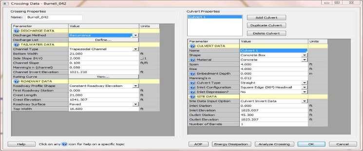
12 Hydraulic Analysis FHWA HY-8 SCREENSHOT 12
13 Hydraulic Analysis Discharge Capacity (Q C ) + Discharge Frequency (RI Q ) curve Capacity Frequency (RI C ) Q C from FHWA HY-8 (cfs) RI Q from USGS StreamStats (years) RI C = capacity recurrence interval (years), based on the overtopping discharge capacity 13
14 Burrell Township Site #42 Discharge Capacity = 284 cfs Capacity Frequency = 430 years 14
15 Prioritization Scheme Hydraulic Adequacy (HA) Compare Capacity Frequency (RI C ) to applicable design guidelines PennDOT Flood Selection Guidelines Based on Functional Classification Minimum Recurrence Intervals Functional Classification Minimum Recurrence Interval (years) Interstate and Limited HA Access < PADOT Highways = Poor50 Principal Arterial System 50 Minor Arterial System 25 HA > 50 years = Good Rural Collector System, Major 25 Other Collector Systems 10 Local Road and Street Systems 10 PADOT < HA < 50 years = Moderate 15
16 Prioritization Scheme 16


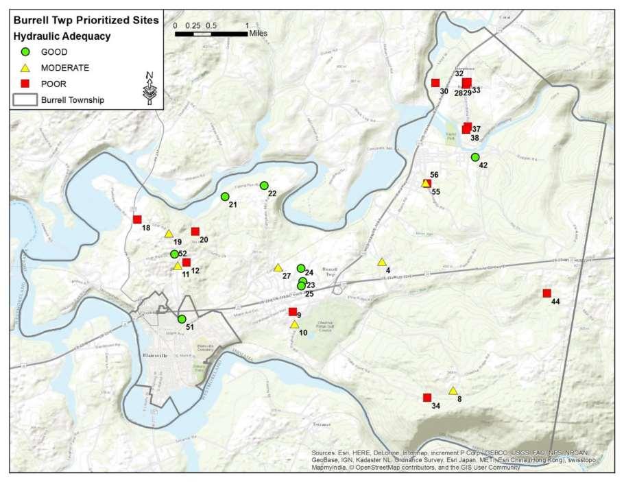
17 Results RI C = 844 years RI C = 0.4 years Burrell Township Case Study Additional considerations: Traffic volume Physical condition Surrounding land use Observed performance 17

18 Lessons Learned Safety First: Travel in pairs, wear PPE Training Data collection Hydraulic definitions Bridge vs. Culvert Natural channels GPS issues Understand GIS data limitations 18
19 Challenges & Opportunities Challenges to Success Feedback loop Monitoring Networking Opportunities to Improve Structural integrity/adequacy Asset management Climate change Flood response with increasing rainfall intensity Fish passage considerations Act Monitor Feedback Loop Modify Assess 19


20 Asset Management in a Changing World ~from Groisman et al Contemporary Changes of the Hydrological Cycle Trends Derived from In Situ Observations Closed, over-topped roads washed-out roads 20
 assuming continued increases in global emissions (A2) and")
21 Asset Management in a Changing World What s increasing rain intensity? A warmer atmosphere s capacity to hold more moisture & energy. Projected number of days/year with maximum temps greater than 90 F averaged between , compared to (Historical Climate) assuming continued increases in global emissions (A2) and substantial reductions in future emissions (B1). Take-away: even under the reduced emissions model, we may anticipate warmer temps w/ an increase in rainfall intensity. ~ from NOAA NCDC/CICS-NC 21


22 Asset Management in a Changing World Under-sized or otherwise insufficient crossings for future rainfall events may be indicated by current: Outlet drops with scour pools high velocities, turbulence, erosion, debris blockages, and 22
 passage, with longitudinal connectivity")
23 Asset Management in a Changing World or by fish crossing the road! Under-sized crossings are also common problems for fish (& wildlife) passage, with longitudinal connectivity an increasing concern for a warmer future. 23

24 Asset Management & Fish Passage? 24

25 Future Asset Management, including Potential Fish (& Wildlife) Passage Well-designed crossings include: Large size for high flows Open-arch design, preserving the natural stream channel Openness ratio > 0.5 m Crossing span, maintaining dry passage for wildlife Water depth & velocity comparable to upstream and downstream Natural substrates, creating good conditions for stream dwelling animals ~from Massachusetts Steam Crossings Handbook 25


26 Potential Fish & Wildlife Passage? Well-designed box culvert (The below are not Brook Trout!) Massachusetts Steam Crossings Handbook, at: North Atlantic Aquatic Connectivity Collaborative, at: 26
 Protocols & training for assessing")


27 Future Asset Management North Atlantic Aquatic Connectivity Collaborative (NAACC) Protocols & training for assessing road-stream crossings Regional database for field data Identify high priority bridges & culverts for upgrade and replacement Roadsoft Roadway asset management system Michigan Department of Transportation Integrates local roads into the State database 27
28 Summary Planning Assistance to States (PAS) cost share program Partnership with the Southwest Pennsylvania Commission (SPC) Field reconnaissance, survey, and data collection H&H analysis using readily available tools Risk-informed approach to prioritize storm water infrastructure improvement Improve and extend the methods to other municipalities 28
29 Questions? Sara Woida, Tom Maier, Michael Debes, 29
, or appropriations.")
30 Authorization & Program Information Continuing Authorities Programs (CAP) -- can be conducted without obtaining a project-specific study or construction authorization (above), or appropriations. Other Pittsburgh District Authorities requiring only projectspecific appropriations 30
31 Continuing Authority Programs CAP Eligible Activities MAXIMUM Federal Construction Cost Share (C/S) Per Project Federal Limit Program Federal Limit (annual) Sec. 14 Streambank and shoreline erosion of public works and nonprofit services 65% $5M $20M Sec. 107 Navigation improvements 50% for recreational-- varies for navigation Sec. 111 Prevention/mitigation of shore damage caused by Federal navigation projects C/S same proportion as original project* $10M $50M $10M N/A Sec. 204 Beneficial use of dredged material 65% N/A $50M Sec. 205 Flood control 65% $10M $55M Sec. 206 Aquatic ecosystem restoration 65% $10M $50M Sec. 208 Sec Obstruction removal & clearing channels for flood control Project modifications for improvement of the environment 65% $0.5M $7.5M 75% $10M $40M 31
32 Other Pittsburgh District Authorities Authority Eligible Activities MAXIMUM Federal Construction Cost Share (C/S) Per Project Federal Limit Program Federal Limit (annual) Planning Assistance to States Technical assistance in water resource planning on a regional and comprehensive scope. 50% $5M annually per state $30M Floodplain Management Services (FPMS) Sec. 219 Environmental Infrastructure Sec. 313 South Central Pennsylvania Environment Infrastructure Technical assistance with flood and floodplain issues Resource protection and development of waste water treatment, water supply storage, etc. Same as Sec. 219, except limited to SW & South-Central PA counties (including Westmoreland County) 100% N/A $50M 75% N/A $30M 75% N/A $200M 32

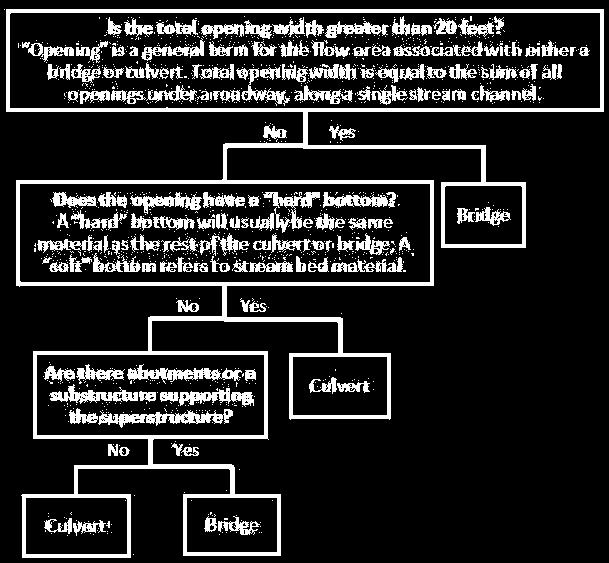
33 Bridge vs. Culvert 33
REPLACING CULVERTS FOR FLOOD RESILIENCY AND AQUATIC CONNECTIVITY. Cheryl Bondi and Lori Sommer NHDES Aquatic Resource Mitigation Program
 REPLACING CULVERTS FOR FLOOD RESILIENCY AND AQUATIC CONNECTIVITY Cheryl Bondi and Lori Sommer NHDES Aquatic Resource Mitigation Program How do stream crossings impact aquatic ecosystems and public safety?
PEARCE CREEK CONFINED DISPOSAL AREA MODIFICATION
 US Army Corps of Engineers Philadelphia District PEARCE CREEK CONFINED DISPOSAL AREA MODIFICATION CECIL COUNTY MARYLAND STORMWATER MANAGEMENT PLAN NARRATIVE INITIAL SUBMISSION JUNE 2014 1 PEARCE CREEK
Chapter 11 Culverts and Bridges
 Chapter 11 Culverts and Bridges Contents 1.0 Introduction... 1 2.0 General Design... 1 2.1 Design Criteria... 1 2.2 Design Flows... 1 2.3 Permitting and Regulations... 1 2.4 Aesthetics and Safety... 2
ILLINOIS URBAN MANUAL PRACTICE STANDARD TEMPORARY STREAM CROSSING (no.) CODE 975. Source: Hey and Associates, Inc.
 CODE 975. Source: Hey and Associates, Inc.") ILLINOIS URBAN MANUAL PRACTICE STANDARD TEMPORARY STREAM CROSSING (no.) CODE 975 Source: Hey and Associates, Inc. DEFINITION A bridge or culvert crossing installed across a stream or watercourse for short-term
ILLINOIS URBAN MANUAL PRACTICE STANDARD TEMPORARY STREAM CROSSING (no.) CODE 975 Source: Hey and Associates, Inc. DEFINITION A bridge or culvert crossing installed across a stream or watercourse for short-term
OFFICE OF STRUCTURES MANUAL ON HYDROLOGIC AND HYDRAULIC DESIGN CHAPTER 3 POLICY AND PROCEDURES
 OFFICE OF STRUCTURES MANUAL ON HYDROLOGIC AND HYDRAULIC DESIGN CHAPTER 3 POLICY AND PROCEDURES April 28, 2016 Table of Contents 3.1 Introduction... 2 3.1.1 Purpose of Chapter 3... 2 3.1.2 Policy vs. Design
Designing roads for fish, floods and foxes
 Designing roads for fish, floods and foxes Calculations 9 Swimming Plunging Flow & Leaping Occupied Velocity Prolonged > Capability Yes Swim in Burst Total Time in Burst Time to > Exhaustion Yes Barrier
CLAY STREET BRIDGE REPLACEMENT
 HYDROLOGY /HYDRAULICS REPORT. EL DORADO COUNTY CLAY STREET BRIDGE REPLACEMENT Prepared by: Joseph Domenichelli Domenichelli & Associates 1107 Investment Blvd., Suite 145 El Dorado Hills, California 95762
SECTION III: WATERSHED TECHNICAL ANALYSIS
 Trout Creek Watershed Stormwater Management Plan SECTION III: WATERSHED TECHNICAL ANALYSIS A. Watershed Modeling An initial step this study of the Trout Creek watershed was the selection of a stormwater
INFLOW DESIGN FLOOD CONTROL SYSTEM PLAN 40 C.F.R. PART PLANT YATES ASH POND 3 (AP-3) GEORGIA POWER COMPANY
 GEORGIA POWER COMPANY") INFLOW DESIGN FLOOD CONTROL SYSTEM PLAN 40 C.F.R. PART 257.82 PLANT YATES ASH POND 3 (AP-3) GEORGIA POWER COMPANY EPA s Disposal of Coal Combustion Residuals from Electric Utilities Final Rule (40 C.F.R.
INFLOW DESIGN FLOOD CONTROL SYSTEM PLAN 40 C.F.R. PART 257.82 PLANT YATES ASH POND 3 (AP-3) GEORGIA POWER COMPANY EPA s Disposal of Coal Combustion Residuals from Electric Utilities Final Rule (40 C.F.R.
- Site Location and Conditions. A. Project Location. B. Existing Conditions
 H&H Report - Site Location and Conditions Page 1 of 2 A. Project Location 1. Site Identification District County Mu nicipali ty 06 Bucks Hilltown (Twp) Site MINSI TRAIL S.R. 4019 Section 60M Segment 0050
I. Welcome & Introductions WPAC History (Paul Racette, PEC)
") Poquessing Creek Watershed ACT 167 STORM WATER MANAGEMENT PLAN Public Hearing July 10, 2012 I. Welcome & Introductions ---------- WPAC History (Paul Racette, PEC) Primary WPAC Members: Bucks County: Bensalem
Poquessing Creek Watershed ACT 167 STORM WATER MANAGEMENT PLAN Public Hearing July 10, 2012 I. Welcome & Introductions ---------- WPAC History (Paul Racette, PEC) Primary WPAC Members: Bucks County: Bensalem
The North Atlantic Aquatic Connectivity Collaborative (NAACC)
") The North Atlantic Aquatic Connectivity Collaborative (NAACC) Evaluating Road-Stream Crossings Across a Thirteen-State Region Jessie Levine September 14, 2016 NETWC Scale of the Problem Data on 9,064 crossings
The North Atlantic Aquatic Connectivity Collaborative (NAACC) Evaluating Road-Stream Crossings Across a Thirteen-State Region Jessie Levine September 14, 2016 NETWC Scale of the Problem Data on 9,064 crossings
S.R. 0944, Section 015 (Wertzville Road) Bridge over the West Branch of Simmons Creek. Silver Spring Township Cumberland County.
 Bridge over the West Branch of Simmons Creek. Silver Spring Township Cumberland County.") Hydrologic and Hydraulic Report For S.R. 0944, Section 015 (Wertzville Road) Bridge over the West Branch of Simmons Creek Silver Spring Township Cumberland County August 13, 2003 Prepared For Pennsylvania
Hydrologic and Hydraulic Report For S.R. 0944, Section 015 (Wertzville Road) Bridge over the West Branch of Simmons Creek Silver Spring Township Cumberland County August 13, 2003 Prepared For Pennsylvania
Prepared for: City of Jeffersonville. November Prepared by
 JEFFERSONVILLE STORMWATER MASTER PLAN HYDRAULICS APPENDIX JEFFERSONVILLE, INDIANA Prepared for: City of Jeffersonville November 2011 Prepared by Christopher B. Burke Engineering, Ltd. 115 W. Washington
MINNEHAHA COUNTY HIGHWAY DEPARTMENT CULVERT REPLACEMENT REQUEST FORM
 MINNEHAHA COUNTY HIGHWAY DEPARTMENT CULVERT REPLACEMENT REQUEST FORM Instructions & Background Information (This page to be completed by Township personnel) The purpose of this form is to provide a means
Chapter 11 Culverts and Bridges
 Chapter 11 Table of Contents 11-1 Introduction... 1 11-2 General Design... 1 11-2-1 Design Criteria... 1 11-2-2 Design Flows... 1 11-2-3 Permitting and Regulations... 2 11-2-4 Aesthetics and Safety...
Chapter 11 Culverts and Bridges
 Chapter 11 Table of Contents 11-1 Introduction... 1 11-2 General Design... 1 11-2-1 Design Criteria... 1 11-2-2 Design Flows... 1 11-2-3 Permitting and Regulations... 2 11-2-4 Aesthetics and Safety...
Incorporating Restoration Planning and Transportation Controls into the Valley Creek Watershed Act 167 Stormwater Management Plan
 Incorporating Restoration Planning and Transportation Controls into the Valley Creek Watershed Act 167 Stormwater Management Plan Pennsylvania State Section American Water Resources Association Fall 2011
Appendix Q Draft Location Hydraulic Study Report For the State Route 32 Widening Between Fir Street and Yosemite Drive at Dead Horse Slough and South
 Appendix Q Draft Location Hydraulic Study Report For the State Route 32 Widening Between Fir Street and Yosemite Drive at Dead Horse Slough and South Fork Dead Horse Slough in the, California Draft Location
Wood-Pawcatuck Watershed Flood Resiliency Management Plan
 Wood-Pawcatuck Watershed Flood Resiliency Management Plan Project Steering Committee Meeting May 21, 2015 Wood-Pawcatuck Watershed Association Meeting Agenda 10:00 10:05 Welcome and Opening Remarks 10:05
Hydrology and Flooding
 Hydrology and Flooding Background The 1996 flood Between February 4, 1996 and February 9, 1996 the Nehalem reporting station received 28.9 inches of rain. Approximately 14 inches fell in one 48 hour period.
Case Studies in Hazard Class Reductions Implementation of NY s Guidance for Dam Hazard Classification
 Case Studies in Hazard Class Reductions Implementation of NY s Guidance for Dam Hazard Classification Gregory J Daviero, PhD, PE, Principal Kevin Ruswick, PE, CFM, Associate May 2, 2014 Schnabel Engineering
Hydraulic Modeling with HY-8
 Hydraulic Modeling with HY-8 Linda Hansen PE, PWS MI Dept. of Environmental Quality Water Resources Division UP District Floodplain Engineer Today s Outline What is HY-8? Best Applications & Limitations
4. Present Activities and Roles
 4. Present Activities and Roles The present missions, authorities, activities and roles of the various agencies involved with flood protection, floodplain management and flood-damage reduction are identified
Mike Jastremski, CFM Watershed Conservation Director
 Planning for Flood Resilient and Fish Friendly Road-Stream Crossings in CT s Northwest Hills Mike Jastremski, CFM Watershed Conservation Director Presentation Outline Project area Climate threats Field
S.R. 4007, Section 14B PADEP Environmental Assessment Form. Enclosure C Description of Aquatic Habitat
 S.R. 4007, Section 14B PADEP Environmental Assessment Form Description of Aquatic Habitat Cresheim Creek is the only water resource that exists within the project area. No jurisdictional wetlands were
c. Effects of the Project on Public Health, Safety and the Environment
 INTRODUCTION a. Description of Proposed Activity This report is for the hydrologic and hydraulic analysis for the structure located at Sta.100+80.67 on S.R. 0978 in North Fayette Township, Allegheny County,
SECTION IV WATERSHED TECHNICAL ANALYSIS
 A. Watershed Modeling SECTION IV WATERSHED TECHNICAL ANALYSIS An initial step in the preparation of this stormwater management plan was the selection of a stormwater simulation model to be utilized. It
Errata sheet for the Connecticut General Permits May 2, 2017
 Errata sheet for the Connecticut General Permits May 2, 2017 The Corps of Engineers, New England District, has compiled this list of corrections and clarifications for the Connecticut General Permits that
Culvert Sizing procedures for the 100-Year Peak Flow
 CULVERT SIZING PROCEDURES FOR THE 100-YEAR PEAK FLOW 343 APPENDIX A: Culvert Sizing procedures for the 100-Year Peak Flow A. INTRODUCTION Several methods have been developed for estimating the peak flood
Section 6: Stormwater Improvements
 Section 6: Stormwater Improvements A major objective of this study was to identify opportunities for improvements to address the widespread water quality impairments caused by stormwater runoff in the
A Hydrologic Study of the. Ryerson Creek Watershed
 A Hydrologic Study of the Ryerson Creek Watershed Dave Fongers Hydrologic Studies Unit Land and Water Management Division Michigan Department of Environmental Quality May 8, 2002 Table of Contents Summary...2
Errata sheet for the Connecticut General Permits March 26, 2019
 Errata sheet for the Connecticut General Permits March 26, 2019 The Corps of Engineers, New England District, has compiled this list of corrections and clarifications for the Connecticut General Permits
TABLE OF CONTENTS. 1.0 Background Watershed Description Hydrology - HEC-HMS Models Hydraulics - HEC-RAS Models...
 TABLE OF CONTENTS 1.0 Background... 1 2.0 Watershed Description... 1 3.0 Hydrology - HEC-HMS Models... 2 3.1 Hydrologic Approach... 2 3.2 Drainage Areas... 2 3.3 Curve Numbers... 2 3.4 Lag Times... 3 3.5
S.R. 2027, Section 02B PADEP Environmental Assessment Form. Enclosure C Description of Aquatic Habitat
 S.R. 2027, Section 02B PADEP Environmental Assessment Form Description of Aquatic Habitat Water resources that exist within the project area include Hosensack Creek and two palustrine emergent (PEM) wetlands.
LAKE COUNTY HYDROLOGY DESIGN STANDARDS
 LAKE COUNTY HYDROLOGY DESIGN STANDARDS Lake County Department of Public Works Water Resources Division 255 N. Forbes Street Lakeport, CA 95453 (707)263-2341 Adopted June 22, 1999 These Standards provide
MnDOT Flash Flood Vulnerability and Adaptation Assessment Pilot Project DISTRICT 1 SILVER CREEK CASE STUDY
 MnDOT Flash Flood Vulnerability and Adaptation Assessment Pilot Project DISTRICT 1 SILVER CREEK CASE STUDY NOVEMBER 2014 This document is part of a series of short reports based on the full Flash Flood
APPENDIX G DIVERSION AND PELICAN LAKE CUTOFF CHANNELS HYRAULICS AND BRIDGE TECHNICAL MEMORANDUM
 APPENDIX G DIVERSION AND PELICAN LAKE CUTOFF CHANNELS HYRAULICS AND BRIDGE TECHNICAL MEMORANDUM To: File Memo From: Matt Redington, P.E. Project: Watertown South Connector CC: Date: March 6, 2007; revised
Temporary Watercourse Crossing: Culverts
 Temporary Watercourse Crossing: Culverts DRAINAGE CONTROL TECHNIQUE Low Gradient Velocity Control Short Term Steep Gradient Channel Lining Medium-Long Term Outlet Control Soil Treatment Permanent Symbol
Good morning, Chairman Yaw, Chairman Yudichak, Chairman Vulakovich, Chairman Costa,
 Testimony of Patrick McDonnell, Secretary Pennsylvania Department of Environmental Protection Joint Hearing on Flooding and Emergency Response Senate Environmental Resources & Energy and Veterans Affairs
12 DRAINAGE General Administrative Requirements Standards
 12 DRAINAGE 12.1 General The Design-Builder shall conduct all Work necessary to meet the requirements associated with drainage, including culverts, bridge hydraulics, roadway ditches, and closed storm
Hackensack River Flood Reduction Study Update
 Township of River Vale Hackensack River Flood Reduction Study Update November 11, 2013 Purpose of Study To Analyze Where Frequent Flooding Is Impacting Property and How It Might Be Reduced Hackensack River
Lake Samish Comprehensive Stormwater Plan Capital Improvement Recommendations
 Lake Samish Comprehensive Stormwater Plan Capital Improvement Recommendations drainage. The easement could potentially be used to site a surface water quality treatment facility for the flow. The design
Section H Project Description Narrative
 Section H Project Description Narrative Permit No. Pennsylvania Department of Transportation, Engineering District 2-0, 1924 Daisy Street Extension, P.O. Box 342, Clearfield, PA 16830 S.R. 2004, Section
Under a Changing Climate:
 Engineering Methods for Precipitation Under a Changing Climate: Outline of the Problem J. Rolf Olsen Institute for Water Resources U.S. Army Corps of Engineers Alexandria, Virginia ASCE Committee on Adaptation
Bridge Planning Updates. Bridge Planning Practitioners Workshop April 2012
 Bridge Planning Updates Bridge Planning Practitioners Workshop April 2012 Bridge Website Bridge Website Bridge Website Bridge Website BPG 11 Stormwater Management at Rural Bridges Released July 2010 Documents
MnDOT Flash Flood Vulnerability and Adaptation Assessment Pilot Project DISTRICT 6 VULNERABILITY ASSESSMENT
 MnDOT Flash Flood Vulnerability and Adaptation Assessment Pilot Project DISTRICT 6 VULNERABILITY ASSESSMENT NOVEMBER 2014 This document is part of a series of short reports based on the full Flash Flood
Culvert Prioritization Model: Aiding Communities in the Selection of Priority Restoration Projects
 Culvert Prioritization Model: Aiding Communities in the Selection of Priority Restoration Projects SNHPC Meeting January 24, 2017 1 Undersized Culverts! Culvert Sizes (~7,500 VT culverts) 6,000 5,000 69%
FLOOD MAGNITUDE AND FREQUENCY OF LITTLE TIMBER CREEK AT THE CULVERT ON INTERSTATE ROUTE 295 IN HADDON HEIGHTS TOWNSHIP, CAMDEN COUNTY, NEW JERSEY
 FLOOD MAGNITUDE AND FREQUENCY OF LITTLE TIMBER CREEK AT THE CULVERT ON INTERSTATE ROUTE 295 IN HADDON HEIGHTS TOWNSHIP, CAMDEN COUNTY, NEW JERSEY U.S. GEOLOGICAL SURVEY Open-File Report 96-321 Prepared
SECONDARY WETLAND IMPACTS ANALYSIS
 SECONDARY WETLAND IMPACTS ANALYSIS USACE File. SWG-2012-00153 During the development of the Grand Parkway (State Highway 99) Segments H and I-1 from United States Highway 59/Interstate Highway 69 N to
MnDOT Flash Flood Vulnerability and Adaptation Assessment Pilot Project DISTRICT 6 SPRING VALLEY CASE STUDY
 MnDOT Flash Flood Vulnerability and Adaptation Assessment Pilot Project DISTRICT 6 SPRING VALLEY CASE STUDY NOVEMBER 2014 This document is part of a series of short reports based on the full Flash Flood
S.R. 4031, SECTION FVR OVER BEAVER RUN SEGMENT 0170, OFFSET 6093 EAST NANTMEAL TOWNSHIP, CHESTER CO. ENGINEERING DISTRICT 6-0
 S.R. 4031, SECTION FVR OVER BEAVER RUN SEGMENT 0170, OFFSET 6093 EAST NANTMEAL TOWNSHIP, CHESTER CO. ENGINEERING DISTRICT 6-0 HYDROLOGIC & HYDRAULIC STUDY REPORT OCTOBER 2007 Prepared For: Prepared By:
Partnering for Resilient Infrastructure and Ecosystems in Massachusetts
 Partnering for Resilient Infrastructure and Ecosystems in Massachusetts Northeastern Transportation & Wildlife Conference September 10 th, 2018 1 Tim Dexter, MassDOT Highway Division Brad Chase, MA Division
DRAINAGE BASICS Common Terminology & Reference Tools Drainage Components Determine Existing Conditions Calculate Development Requirements
 DRAINAGE BASICS 1 Common Terminology & Reference Tools Drainage Components Determine Existing Conditions Calculate Development Requirements 2 Common Terminology & Useful Tools CFS= Cubic Feet per Second-
3.3 Acceptable Downstream Conditions
 iswm TM Criteria Manual - = Not typically used or able to meet design criterion. 1 = The application and performance of proprietary commercial devices and systems must be provided by the manufacturer and
Transactions on Ecology and the Environment vol 19, 1998 WIT Press, ISSN
 Water surface profiles and scour analysis for a river reach with multiple bridge proposals C.C. Nuthmann & C.C. Chang Sverdrup Civil, Inc., Two Center Plaza, Boston, Massachusetts, USA, 02108 Email: nuthmacc@sverdrup.
DRAINAGE MASTER PLAN FOR THE TOWN OF BLOOMING GROVE AND VILLAGES OF WASHINGTONVILLE AND SOUTH BLOOMING GROVE
 DRAINAGE MASTER PLAN FOR THE TOWN OF BLOOMING GROVE AND VILLAGES OF WASHINGTONVILLE AND SOUTH BLOOMING GROVE PUBLIC MEETING March 8, 2017 LOGISTICS Meeting Agenda: Presentation (7:15 7:45 pm) [Auditorium]
ENVIRONMENTAL ASSESSMENT
 ENVIRONMENTAL ASSESSMENT Section 408 Request to Alter the Brookville Local Protection Project for State Route 3033 Bridge Replacement in Jefferson County, PA May 16, 2018 Prepared By: Environmental and
Presentation Overview
 Little Dry Creek Restoration Deep River Flood Risk Management Final Presentation to LCRBDC June 10, 2015 Presentation Overview Project Overview & Background Information Data Collection Model Development
DRAFT LOCATION HYDRAULIC REPORT
 DRAFT LOCATION HYDRAULIC REPORT West Bay Parkway (CR 388) Segment 2 From SR 79 to SR 77 in Bay County FPID No. 424464-1-22-01 Florida Department of Transportation District Three 1074 Highway 90 East Chipley,
Flash Flood Vulnerability and Climate Adaptation Pilot Project
 Flash Flood Vulnerability and Climate Adaptation Pilot Project Philip Schaffner Office of Transportation System Management Minnesota Department of Transportation MnDOT s Pilot Project Objectives Better
Massachusetts River and Stream Crossing Standards: Technical Guidelines
 Massachusetts River and Stream Crossing Standards: Technical Guidelines August 6, 2004 INTRODUCTION As long and linear ecosystems, rivers and streams are very important for fish and other wildlife movements,
Temporary Stream Crossing
 Categories EC Erosion Control SE Sediment Control TC Tracking Control WE Wind Erosion Control Non-Stormwater NS Management Control Waste Management and WM Materials Pollution Control Legend: Primary Objective
Temporary Stream Crossing
 Temporary Stream Crossing NS-4 Objectives EC Erosion Control SE Sediment Control TR Tracking Control WE Wind Erosion Control Non-Stormwater NS Management Control Waste Management and WM Materials Pollution
LOCATION AND DESIGN DIVISION
 VIRGINIA DEPARTMENT OF TRANSPORTATION LOCATION AND DESIGN DIVISION INSTRUCTIONAL AND INFORMATIONAL MEMORANDUM GENERAL SUBJECT: CULVERT DESIGN SPECIFIC SUBJECT: COUNTERSINKING AND LOW FLOW CONSIDERATIONS
III. INVENTORY OF EXISTING FACILITIES
 III. INVENTORY OF EXISTING FACILITIES Within the Growth Management Boundary, the existing storm drainage facilities are largely associated with development that has historically occurred in the ten drainage
Climate Ready Culverts. Funding
 Climate Ready Culverts Thomas P. Ballestero University of New Hampshire Stormwater Center 2016 INAFSM Annual Conference Florence, IN 7 9 Sep 2016 1 Funding 2 1 Culvert Hydraulics 3 Bridge Versus Culvert
Conceptual Design and Feasibility of a Natural Fishway at the Fremont BART Weir, Alameda Creek, California
 Conceptual Design and Feasibility of a Natural Fishway at the Fremont BART Weir, Alameda Creek, California Final Report September 2005 Prepared by Center for Ecosystem Management and Restoration, Oakland,
Municipal Stormwater Management Planning
 Municipal Stormwater Management Planning Christopher C. Obropta, Ph.D., P.E. Water Resources Extension Specialist with Rutgers Cooperative Extension Assistant Professor with Department of Environmental
Calapooia River Fish Passage Analysis and Culvert Removal Proposal
 Calapooia River Fish Passage Analysis and Culvert Removal Proposal Submitted to: Calapooia Watershed Council P.O. Box 844 Brownsville, OR 97327 Prepared by: Oregon State University Department of Biological
The Beckett s Run Experience. Fort Wayne, Indiana
 The Beckett s Run Experience Fort Wayne, Indiana Introductions Charlie Cochran City of Fort Wayne, Wet Weather Storm & Sewer Engineering Jason Durr, PE Christopher B. Burke Engineering, LLC 2 A Little
HYDROLOGIC & HYDRAULIC ASPECTS of the Walnut Street Bridge over the Schuylkill River Philadelphia, PA
 HYDROLOGIC & HYDRAULIC ASPECTS of the Walnut Street Bridge over the Schuylkill River Philadelphia, PA J. Richard Weggel CAEE201 Lectures 30 April & 2 May 2007 HYDROLOGY (Natural Science) Study of the waters
Forest Practices Technical Note Number 5. Determining the 50-Year Peak Flow and Stream Crossing Structure Size for New and Replacement Crossings
 Forest Practices Technical Note Number 5 Determining the 50-Year Peak Flow and Stream Crossing Structure Size for New and Replacement Crossings Introduction Version 1.0: Effective May 10, 2002 The objective
Integrating Biodiversity & Infrastructure Priorities
 Integrating Biodiversity & Infrastructure Priorities Bill Napolitano Director of Environmental Planning, Southeastern Regional Planning and Economic Development District Jennifer Carlino Conservation Agent
Municipal Stormwater Management Plan Prepared For The Borough of Cape May Point By Van Note-Harvey Associates VNH File No.
 Municipal Stormwater Management Plan Prepared For The Borough of Cape May Point By Van Note-Harvey Associates 2005 VNH File No. 35317-210-21 Table of Contents Introduction... 3 Goals... 3 Storm water Discussion...
Alternatives for Willow Creek Flood Mitigation Study
 Alternatives for Willow Creek Flood Mitigation Study Presented by: Anil Tangirala, PE, CFM, ENV SP ms consultants, inc. June 22, 2016 Presentation Overview Introduction Project Background Willow Creek
Restoring an Urban River in a Historic Setting Lower Pawtuxet River, R.I.
 Restoring an Urban River in a Historic Setting Lower Pawtuxet River, R.I. Thomas Ardito Narragansett Bay Estuary Program Sam Whitin, Andy Lipsky EA Engineering, Science & Technology Rita L. Holahan, Pawtuxet
Plan Rollout Presentation July 31, Michael G. Hahn, P.E., P.H. Chief Environmental Engineer. Southeastern Wisconsin Regional Planning Commission
 Plan Rollout Presentation July 31, 2014 Michael G. Hahn, P.E., P.H. Chief Environmental Engineer Southeastern Wisconsin Regional Planning Commission # 219703 Racine County Flooding Recommendations and
Wood-Pawcatuck Watershed Flood Resiliency Management Plan Community Meeting October 20, 2016
 Wood-Pawcatuck Watershed Flood Resiliency Management Plan Community Meeting October 20, 2016 Wood-Pawcatuck Watershed Association Meeting Agenda 10:00 10:05 Introductions and Meeting Goals 10:05 10:15
PUBLIC NOTICE. Section 404 of the Clean Water Act (33 U.S.C. 1344) Section 10 of the Rivers and Harbors Act of 1899 (33 U.S.C.
 Section 10 of the Rivers and Harbors Act of 1899 (33 U.S.C.") US Army Corps Of Engineers Wilmington District PUBLIC NOTICE Issue Date: June 17, 2014 Comment Deadline: July 17, 2014 Corps Action ID#: SAW-2009-00655 NC DOT TIP: R-4903 The Wilmington District, Corps
US Army Corps Of Engineers Wilmington District PUBLIC NOTICE Issue Date: June 17, 2014 Comment Deadline: July 17, 2014 Corps Action ID#: SAW-2009-00655 NC DOT TIP: R-4903 The Wilmington District, Corps
Gwinnett County Stormwater System Assessment Program
 Gwinnett County Stormwater System Assessment Program Jonathan Semerjian, PE Dept. of Water Resources Stormwater Management Sam Fleming, PE Dewberry Presentation Overview Project Background Drivers Enhanced
Drainage Criteria Manual Review
 City of Colorado Springs Stormwater Management Assessment and Standards Development Drainage Criteria Manual Review March 8, 2013 Springsgov.com/City Agencies/Stormwater/Stormwater Engineering/ Stormwater
SHORELINE INVENTORY AND RESTORATION PLANNING
 CHAPTER 3 SHORELINE INVENTORY AND RESTORATION PLANNING A. PURPOSE OF THE SHORELINE INVENTORY AND CHARACTERIZATION A first step in the comprehensive Master Program update process is development of a shoreline
Chapter 6 Hydrology TABLE OF CONTENTS CHAPTER 6 - HYDROLOGY
 Chapter 6 Hydrology TABLE OF CONTENTS CHAPTER 6 - HYDROLOGY... 6-1 6.1 Introduction... 6-1 6.1.1 Objective... 6-1 6.1.2 Definition... 6-1 6.1.3 Factors Affecting Floods... 6-1 6.1.4 Sources of Information...
The prioritization list along with the estimated probable construction cost and future cost index is shown in Table 1.
 EXECUTIVE SUMMARY To address flooding concerns and assess costs of potential capital improvement projects associated with flooding in the downtown Town Center Area Plan (TCAP), the Town of Cary commissioned
Hydraulic Report. County Road 595 Bridge over Mulligan Creek. Prepared By AECOM Brian A. Hintsala, P.E
 Prepared for: Prepared by: Marquette County Road Commission AECOM Ishpeming, MI Marquette, MI 60240279 December 9. 2011 Hydraulic Report County Road 595 Bridge over Mulligan Creek Prepared By AECOM Brian
SEWRPC Staff Memorandum
 SEWRPC Staff Memorandum EVALUATION OF PROPOSED STORMWATER QUANTITY MANAGEMENT FOR THE DES PLAINES RIVER WATERSHED PORTION OF THE PROPOSED FOXCONN DEVELOPMENT IN THE VILLAGE OF MOUNT PLEASANT June, 2018
FINAL ENVIRONMENTAL ASSESSMENT
 FINAL ENVIRONMENTAL ASSESSMENT Section 408 Request to Alter the Big Run Local Protection Project for State Route 2003 Bridge Replacement in Jefferson County, PA March 15, 2018 Prepared By: Environmental
Estimating the 100-year Peak Flow for Ungagged Middle Creek Watershed in Northern California, USA
 American Journal of Water Resources, 2014, Vol. 2, No. 4, 99-105 Available online at http://pubs.sciepub.com/ajwr/2/4/3 Science and Education Publishing DOI:10.12691/ajwr-2-4-3 Estimating the 100-year
Hydraulic Report. County Road 595 Bridge over Dead River. Prepared By AECOM Brian A. Hintsala, P.E
 Prepared for: Prepared by: Marquette County Road Commission AECOM Ishpeming, MI Marquette, MI 60240279 December 9, 2011 Hydraulic Report County Road 595 Bridge over Dead River Prepared By AECOM Brian A.
Wisconsin Hydraulic Geometry Regional Curves
 Wisconsin Hydraulic Geometry Regional Curves Marie Peppler and Faith Fitzpatrick, USGS, Middleton, WI Michigan Stream Team Conference Call February 17, 2010 Objectives Develop relations between channel
State Standard. for. Stormwater Detention/Retention
 ARIZONA DEPARTMENT OF WATER RESOURCES FLOOD MITIGATION SECTION State Standard for Stormwater Detention/Retention Under the authority outlined in ARS 48-3605(a) the Director of the Arizona Department of
2. DEFINITIONS. American Association of State Highway and Transportation Officials.
 2. DEFINITIONS 2.010 Definitions [See Amendment 2] In addition to words and terms that may be defined elsewhere in this manual, the following words and terms shall have the meanings defined below: AASHTO:
Freight Street Development Strategy
 Freight Street Development Strategy Appendix B: Naugatuck River Floodplain Analysis Freight Street Development Strategy DECEMBER 2017 Page B-1 1.0 NAUGATUCK RIVER FLOODPLAIN AT FREIGHT STREET 1.1 Watershed
Wood-Pawcatuck Watershed Flood Resiliency Management Plan
 Wood-Pawcatuck Watershed Flood Resiliency Management Plan Project Steering Committee Kickoff Meeting March 26, 2015 Wood-Pawcatuck Watershed Association Meeting Agenda 10:00 10:05 Welcome and Opening Remarks
City of Madison: 2017 Capital Budget Capital Improvement Plan
 City of Madison: 2017 Capital Budget Capital Improvement Plan Agency: Stormwater Utility Project Summary Backyard Drainage Problems 25,000 25,000 25,000 25,000 25,000 25,000 CIPP Lining Storm Sewer 100,000
Office of Strategic Planning and Projects Connecticut Department of Transportation CLIMATE CHANGE & EXTREME WEATHER PILOT PROJECT
 Office of Strategic Planning and Projects Connecticut Department of Transportation CLIMATE CHANGE & EXTREME WEATHER PILOT PROJECT LITCHFIELD HILLS Lake Waramaug, Warren/Kent/Washington LITCHFIELD HILLS
Section 1000 Culverts and Bridges Table of Contents
 Section 1000 Culverts and Bridges Table of Contents 1001 INTRODUCTION... 1000 1 1002 CULVERT DESIGN STANDARDS... 1000 1 1002.1 CONSTRUCTION MATERIALS... 1000 1 1002.2 MINIMUM CULVERT SIZE... 1000 2 1002.3
Paxton Creek Watershed TMDL Strategy
 Paxton Creek Watershed TMDL Strategy Public Review Meetings: November 17, 2015 November 18, 2015 December 10, 2015 Paxton Creek Watershed Cooperative Progressive approach to achieving water quality improvements.
Jacobi, Toombs, and Lanz, Inc.
 Area 5: Blackiston Mill Road at Dead Man's Hollow Flooding Assessment Jacobi, Toombs, and Lanz, Inc. This document summarizes an assessment of drainage and flooding concerns and provides recommendations