Great Lakes Water Levels
|
|
|
- Bridget Dickerson
- 5 years ago
- Views:
Transcription

1 Great Lakes Water Levels What are the factors that influence Great Lakes water levels? What is the normal range of Great Lakes water levels? What about Lakes Michigan-Huron? Environmental and Socio-Economic Impacts Climate Variability and the future Water levels go up, water levels go down.
2 Great Lakes Cross Section Lake Superior ft Lakes Michigan Lake and Huron St. Clair ft Lake Erie ft Niagara Falls Lake Ontario 925 ft 752 ft 212 ft ft St. Lawrence River 20.6 ft 1333 ft 804 ft Distance in Miles Great Lakes Basin Framework Study
 Inflows and Outflows Connecting Channel Flows between")
3 What Drives Water Level Change? Climate Precipitation + Runoff Evaporation = NBS Seasonal changes in climate (annual) Inflows and Outflows Connecting Channel Flows between Lakes Water-Level Regulation Diversions (into and out of basin) Consumptive Uses Wind and Storm Events (short term)

4 Great Lakes Water Balance Lake water levels are climatically driven by seasonal changes in precipitation and evaporation. Evaporation is affected by surface water temperature, wind speed, and presence/absence of ice cover. Inflows/outflows via connecting channels between Lakes St. Marys River St. Clair/Detroit River Niagara River St. Lawrence River mm on the Lake Surface mm on the Lake Surface Source: Great Lakes Environmental Research Laboratory Runoff Precip Evap Jan Feb Mar Apr May Jun Jul Aug Sept Oct Nov Dec Month Month Net Basin Supply (P + R - E) Jan Feb Mar Apr May Jun Jul Aug Sept Oct Nov Dec
. St.")
5 Hydrological Components Lake Superior 56% precipitation 40% runoff 4% diversions % evaporation 57% outflow Lake Michigan- Huron 39% precipitation 34% runoff 27% inflow % evaporation 68% outflow 1% Chicago diversion Long Lac/ Ogoki 154 m 3 /s (5400 cfs). St. Marys River 2110 m 3 /s Hydrologic Values Lake Ontario 79% inflow 15% runoff 6% precipitation % outflow 7% evaporation St. Lawrence 7060 m 3 /s Lake Erie 79% inflow 11% precipitation 10% runoff % outflow 11% evaporation Chicago Diversion 91 m 3 /s (3,200 cfs) St. Clair/Detroit River 5360 m 3 /s Niagara River 5780 m 3 /s Courtesy IUGLS
6 Diversions and Impacts Lake Superior +9 cm (+3.5 ) 0 0 Net +9 cm (+3.5 ) Long Lac/ Ogoki 154 m 3 /s (5,400 cfs). Great Lakes Connecting Channel Diversion in Diversion out Lake Michigan- Huron Sault St. Marie Control Structures Diversion within +11 cm (+4.3 ) -6 cm (-2.4 ) -4 cm (-1.6 ) Net +1 cm (+0.4 ) Cornwall Massena Control Structures Lake Erie +7 cm (+2.8 ) -4 cm (-1.6 ) -12 cm (-4.7 ) Net -9 cm (-3.5 ) St. Clair River Welland Canal 244 m 3 /s (8620 cfs) Chicago Diversion 91 m 3 /s (3,200 cfs) Courtesy IUGLS

7 Lake Ontario Regulation Begins Basinwide Drop in GL Water Levels

8 August 2013 Forecast
9 Environmental Low Water Impacts Shifts in shoreline position/location (loss/gain wetlands) Loss of hydraulic connectivity (Georgian Bay wetlands/tributaries) Changes in seasonal magnitude, timing and duration Altered tributary flows and Lake circulation patterns Degradation of water quality Socio-Economic Commercial Shipping Recreational Boating/Marina Operation Coastal hazards (erosion and flooding) Public Health and Safety (water quality) Property Access

10 Glacial Isostatic Adjustment Glacial Isostatic Adjustment (GIA) in northern Lake Huron and Lake Superior exacerbates impact of low Lake Michigan-Huron water levels. Rates are cm/100 years relative to Lake outlet elevations.


.")
 Post 1962 dredging 25 cm (9.8 ) Plus 27-ft channel (1959-1962) 40 cm (15.")
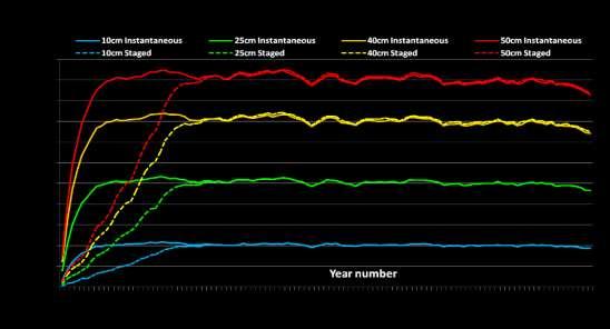
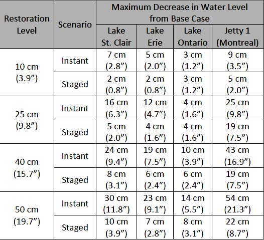
11 IUGLS - Lake Michigan-Huron Water Levels Long-term change in the head between Lakes Michigan-Huron and Lake Erie. Possible erosion/increased conveyance in St. Clair River due to dredging and sand mining? 1962 last time major dredging occurred on St. Clair River (subsequent maintenance dredging lower reaches only). Level Restoration Scenarios Rationale 0 cm (0.0 ) No change 10 cm (3.9 ) Post 1962 dredging 25 cm (9.8 ) Plus 27-ft channel ( ) 40 cm (15.7 ) Plus 1930 mining & 25-ft channel 50 cm (19.7 ) All alterations since A 2 No compensation for St. Clair River dredging (25 and 27 ft channels). 8
12 IJC Recommendations - St. Clair River Recommends further investigation to restore Lake Michigan-Huron water levels Recommends that the governments undertake further investigation of options to increase water levels in Lakes Michigan-Huron by 13 to 25 cm (about 5 to 10 inches). Investigation to be funded, undertaken, and concluded as quickly as possible. Criteria and Deliverables Explore options that would provide relief during low water periods, but not exacerbate future high water levels, and Provide a comprehensive binational benefit-cost analysis and a detailed environmental impact study of potential structural options.
13 IJC Recommendations - Lake Superior IJC Endorses Lake Superior Regulation Plan Plan 2012 delivers robust performance over a wide range of possible hydrologic conditions. Preparing supplemental Orders of Approval to implement Plan IJC Recommendations - Multi-Lake Regulation Further study of Multi-Lake Regulation is not warranted. Climate uncertainties, high cost, institutional requirements, and environmental concerns Regulation of Great Lakes Water Levels and 1993 IJC Levels Reference Study reached similar conclusions.
14 IJC Recommendations - Adaptive Management Endorses implementation of a comprehensive Adaptive Management approach supported by Science and Monitoring Established International Great Lakes St. Lawrence River Adaptive Management Task Team to further develop a detailed adaptive management plan. Strengthening hydroclimate monitoring and modeling; Ongoing risk assessment; Ensuring more comprehensive information management and outreach; Improving tools and processes for decision makers; Collaborative regional adaptive management study for addressing water level extremes; and Integration of water quality and quantity modeling activities.
15 Climate Variability and Water Levels According to the most recent climate models, the climate in the upper Great Lakes basin during the next years is likely to be characterized by: Increase in storm severity - an increase in precipitation and more frequent and intense storms (weather variability); Increase in evaporation - an increase in lake evaporation resulting from higher surface water temperatures and wind speeds, lack of winter ice; Change in seasonal timing - increased water supply during winter/spring months accompanied by larger decreases in supply during summer/early fall resulting in slight overall annual declines.
16 Future Great Lakes Water Levels Great Lakes water levels are anticipated to remain below long-term historic mean water levels, but generally within the range of historic water levels. Anticipate more extreme and variable water level events, i.e. anticipate both low and high water level regimes that may exceed historic thresholds, both low and high. Lower Lake Michigan-Huron water levels may continue to occur irrespective of St. Clair River compensation. St. Clair River compensation may reduce, but not eliminate potential low water-level impacts on Lakes Michigan-Huron. Adaptive management is still required to plan for (and respond to) extreme water level events whether or not St. Clair River compensation is implemented.
17 Questions?
18
19 Late Holocene Lake Levels - Lakes Michigan/Huron Historical record Measured Inferred 177 ~160-year fluctuation Algoma phase ~30-year fluctuation Nipissing II phase Historical average ( ) v Calendar year before AD BC Year Courtesy Todd A. Thompson - Indiana Geological Survey

20 August 2013 Forecast
21 Lake Superior Water Level Regulation Sabin Rule ( ) Rule P-5 ( ) Rule of 1949 ( ) 1955 Modified Rule of 1949 ( ) SO-901 ( Guide ) Plan 1977 ( ) Plan 1977A (1990-present) Plan 2012 proposed
22 Water Level (m, IGLD 85) Water Level (m, IGLD 85) Plan 77A and PreProject Lake Superior Level Pre-Project Plan 77A Lake Michigan-Huron Level


23 St. Clair River Restoration
24
Lake Levels: Where has all the water gone February 7, 2013
 Lake Levels: Where has all the water gone? February 7, 2013 Photo by Jeff J. Cashman n this Nov. 16, 2012 photo, the white streaks on a steel breakwall show the normal water level n Portage Lake at Onekama,
Agenda. Evaluation of Lake Superior Regulation Plans Using Robustness and Climate Informed Risk
 2/6/22 Evaluation of Lake Superior Regulation Plans Using Robustness and Climate Informed Risk Paul Moody 3 Feb 22 Agenda Overview and Background Decision Scaling Process Climate Response Function Application
International Upper Great Lakes Study. Muskegon, Michigan Public Meeting May 3, 2008
 International Upper Great Lakes Study Muskegon, Michigan Public Meeting May 3, 2008 Presenters Kay Felt U.S. co-chair, Public Interest Advisory Group Dr. Eugene Stakhiv U.S. co-chair, IUGL Study Board
Regulation of Lake Superior Outflows
 Regulation of Lake Superior Outflows Rob Caldwell, Env. Can., GL-SLRO, Cornwall, ON Scott Thieme, USACE Detroit District October 29, 2007 St. Marys River at Sault Ste. Marie Looking East (Downstream) Sugar
GREAT LAKES WATER LEVEL REGULATIONS
 JOHN G. SHEDD AQUARIUM WHITE PAPER PROJECT 2011 GREAT LAKES WATER LEVEL REGULATIONS By: Beth Engel I. INTRODUCTION The Great Lakes Basin, storing 5,439 mi 3 of water, is comprised of the lakes and connecting
International Upper Great Lakes Study. Bay City &Port Huron, Michigan Public Meetings April 28-29, 2008
 International Upper Great Lakes Study Bay City &Port Huron, Michigan Public Meetings April 28-29, 2008 Presenters Kay Felt U.S. co-chair, Public Interest Advisory Group Dr. Eugene Stakhiv U.S. co-chair,
Exploring the Possibilities At Prado Dam
 Exploring the Possibilities At Prado Dam Greg Woodside, P.G., C.HG. Executive Director of Planning & Natural Resources December 5, 2017 The Orange County groundwater basin lies at the base of the Santa
Great Lakes Update. Volume 189: 2013 January through June Summary
 Great Lakes Update Volume 189: 2013 January through June Summary The U.S. Army Corps of Engineers (USACE) tracks the water levels of each of the Great Lakes. This report highlights hydrologic conditions
The Great Lakes. 35 million live in the basin (US and Canada). Regional production of
. Regional production of") 1 The Great Lakes 35 million live in the basin (US and Canada). Regional production of two trillion USD. Ontario parks located on the Great Lakes attract 11 million visitors a year. 2 The Great Lakes are
1 The Great Lakes 35 million live in the basin (US and Canada). Regional production of two trillion USD. Ontario parks located on the Great Lakes attract 11 million visitors a year. 2 The Great Lakes are
ADAPTIVE MANAGEMENT STRATEGY Coping Zones
 ADAPTIVE MANAGEMENT STRATEGY Coping Zones IDENTIFYING VULNERABILITIES THROUGH THE DEVELOPMENT OF COPING ZONES SEPTEMBER 23, 2011 Prepared by: Daniel Ferreira Environment Canada Adaptive Management Group
IUGLS Plan Formulation & Evaluation Group (PFEG)
") DATE: June 24, 2011 MEMORANDUM FROM: PROJECT: TO: Todd Redder, Joe DePinto, Scudder Mackey IERM3 IUGLS Plan Formulation & Evaluation Group (PFEG) CC: SUBJECT: Guidance for Evaluating Ecological Responses
DATE: June 24, 2011 MEMORANDUM FROM: PROJECT: TO: Todd Redder, Joe DePinto, Scudder Mackey IERM3 IUGLS Plan Formulation & Evaluation Group (PFEG) CC: SUBJECT: Guidance for Evaluating Ecological Responses
IMPACTS ON UPPER GREAT LAKES WATER LEVELS: ST. CLAIR RIVER SUMMARY REPORT
 IMPACTS ON UPPER GREAT LAKES WATER LEVELS: ST. CLAIR RIVER SUMMARY REPORT FINAL REPORT TO THE INTERNATIONAL JOINT COMMISSION DECEMBER 2009 Report Cover The front cover shows two images of the St. Clair
Change for Western North America. Hydrologic Implications of Climate. and the Columbia River Basin. Dennis P. Lettenmaier. Alan F.
 Hydrologic Implications of Climate Change for Western North America and the Columbia River Basin Alan F. Hamlet, Philip W. Mote, Dennis P. Lettenmaier JISAO/CSES Climate Impacts Group Dept. of Civil and
Climate Change and Great Lakes Natural Systems. Climate Change and Water in the Great Lakes Region, ARC Webinar October 21, 2008
 Climate Change and Great Lakes Natural Systems Linda Mortsch Adaptation and Impacts Research Division, Environment Canada Climate Change and Water in the Great Lakes Region, ARC Webinar October 21, 2008
International Joint Commission
 International Joint Commission The International Lake Ontario - St. Lawrence River Study: An in-depth, five-year study to determine if and how we can improve upon the way we manage levels and outflows
Regulation Plan 2014 for the Lake Ontario and the St. Lawrence River. Compendium Document
 Regulation Plan 2014 for the Lake Ontario and the St. Lawrence River Compendium Document December 2016 Table of Contents Letter of Concurrence from the Governments of Canada and the United States... 3
VARIATION IN GREAT LAKES LEVELS IN RELATION TO ENGINEERING PROBLEMS
 INTRODUCTION CHAPTER 17 VARIATION IN GREAT LAKES LEVELS IN RELATION TO W. E. McDonald Great Lakes Division, Corps of Engineers Chicago, Illinois Throughout the recorded history of the Great Lakes, the
Reservoir Drought Operations
 Reservoir Drought Operations Kevin J. Landwehr, P.E., D.WRE Chief, Hydrology and Hydraulics Branch 4 March 2013 Purpose Awareness of Drought Contingency Plans 2012/13 Reservoir Operations Drought Management
Water and Climate Change: How to Develop an Adaptation Strategy In Transboundary Basins [UNECE Workshop Geneva]
![Water and Climate Change: How to Develop an Adaptation Strategy In Transboundary Basins [UNECE Workshop Geneva]](/thumbs/87/95227829.jpg "Water and Climate Change: How to Develop an Adaptation Strategy In Transboundary Basins [UNECE Workshop Geneva]") Water and Climate Change: How to Develop an Adaptation Strategy In Transboundary Basins [UNECE Workshop Geneva] Eugene Stakhiv, US Director IUGLS May 10-11, 11, 2010 Outline A little about the IJC A little
Water and Climate Change: How to Develop an Adaptation Strategy In Transboundary Basins [UNECE Workshop Geneva] Eugene Stakhiv, US Director IUGLS May 10-11, 11, 2010 Outline A little about the IJC A little
WATER LEVELS ON THE GREAT LAKES
 OHSU EP-101 2013 BACKGROUND There is something about the movement of waves against the beach, the sight of a sailboat going past, and the ability to plunge in to the water on a hot summer day that attracts
3.0 Regulation Plan Review
 The total cost for the St. Clair River evaluation would be about $3,500K (U.S. dollars). This is equivalent to about $4,200K in Canadian dollars. 3.0 Regulation Plan Review The principal purpose of this
EXECUTIVE SUMMARY OF THE
 Great Lakes Diversions and Consumptive Uses EXECUTIVE SUMMARY OF THE REPORT to the International Joint Commission by the International Great Lakes Diversions and Consumptive Uses Study Board (Under the
Water Supply Reallocation Workshop
 Water Supply Reallocation Workshop Determining Yield and Storage Requirement June 2, 2009 Tulsa, OK James Hathorn, Jr Redistribution of Water The function of a reservoir system is to redistribute the natural
Climate Change Impacts for the Central Coast and Hunter Regions
 Climate Change Impacts for the Central Coast and Hunter Regions http://www.ozcoasts.gov.au/climate/ima ges/f1_risks.jpg Peter Smith 1 Climate change will have increasing impacts on a wide range of natural
Song Lake Water Budget
 Song Lake Water Budget Song Lake is located in northern Cortland County. It is a relatively small lake, with a surface area of about 115 acres, and an average depth of about 14 feet. Its maximum depth
Hydrologic Implications of Climate Change for the Western U.S., Pacific Northwest, and Washington State
 Hydrologic Implications of Climate Change for the Western U.S., Pacific Northwest, and Washington State Alan F. Hamlet JISAO/CSES Climate Impacts Group Dept. of Civil and Environmental Engineering University
Adapting to Wisconsin s Changing Climate
 Adapting to Wisconsin s Changing Climate FEMA Frank Koshere Anvil Lake Association Tim Asplund, WDNR Water Resource Monitoring Section Water Program Rep., WICCI Science Advisory Board ILMA, February 20,
Maintaining Water Supply Resilience in Extreme Times
 Maintaining Water Supply Resilience in Extreme Times Presented to the Western Coalition of Arid States June 20, 2018 Presentation Outline: Snapshot of Reclamation Offices West-wide Precipitation and Storage
PEACE RIVER MANASOTA REGIONAL WATER SUPPLY AUTHORITY BOARD OF DIRECTORS MEETING December 5, 2018 ROUTINE STATUS REPORTS ITEM 1
 PEACE RIVER MANASOTA REGIONAL WATER SUPPLY AUTHORITY BOARD OF DIRECTORS MEETING December 5, 218 ROUTINE STATUS REPORTS ITEM 1 Hydrologic Conditions Report MEMORANDUM Project: Hydrologic Conditions Report
Irrigation modeling in Prairie Ronde Township, Kalamazoo County. SW Michigan Water Resources Council meeting May 15, 2012
 Irrigation modeling in Prairie Ronde Township, Kalamazoo County SW Michigan Water Resources Council meeting May 15, 2012 Development of a Groundwater Flow Model INFLOWS Areal recharge from precipitation
Climate Change, Water Levels, Adaptation, and the Lake Erie Ecosystem
 Climate Change, Water Levels, Adaptation, and the Lake Erie Ecosystem Scudder D. Mackey, Ph.D. University of Windsor/Habitat Solutions Lake Erie Millennium Conference April 2010 Windsor, Ontario Today
Water Resources Vulnerability and Adaptation to Climate Change
 Water Resources Vulnerability and Adaptation to Climate Change Linda Mortsch Adaptation and Impacts Research Group, Environment Canada Looking Forward Opportunities for Adapting to Global Warming, MAWWEC
San Antonio Water System Mitchell Lake Constructed Wetlands Below the Dam Preliminary Hydrologic Analysis
 San Antonio Water System enhancement. This recommendation was based on limited water quality data provided by SAWS and using a free-water surface constructed wetland with approximately 112 acres of wetted
Spring Forecast Based Operations, Folsom Dam, California
 Spring Forecast Based Operations, Folsom Dam, California Paul E. Pugner, P.E. Chief, Water Management Section Sacramento District U.S. Army 1325 J Street, Room 1126 Sacramento, CA 95814-2922 Tel: (916)
The Impacts of Climate Change on Portland s Water Supply
 The Impacts of Climate Change on Portland s Water Supply Richard Palmer and Margaret Hahn University of Washington Department of Civil and Environmental Engineering Joe Dvorak, Dennis Kessler, Azad Mohammadi
An Investigation into the 2012 drought on Apalachicola River. Steve Leitman, Bill Pine and Greg Kiker
 An Investigation into the 2012 drought on Apalachicola River Steve Leitman, Bill Pine and Greg Kiker Apalachicola-Chattahoochee-Flint (ACF) River basin 20,400 sq. mi. One of the most actively disputed
Sobhalatha Kunjikutty
 Sobhalatha Kunjikutty Conservation Ontario _ Climate Change Workshop February 9, 2011 Overview Identify Risk Risk Evaluation Primary & Secondary Impacts Resource Management Implications Adaptive Response
Rainwater Harvesting
 Rainwater Harvesting A strategy for water conservation, stormwater management and sustainable development in the City of Tucson Ann Audrey, Environmental Projects Coordinator Tucson Office of Conservation
WaterNSW Water Operations Report. Murray-Lower Darling November 2017
 WaterNSW Water Operations Report Murray-Lower Darling 110% 100% Dam Storages Dartmouth Dam Storage 2013/14 2014/15 2015/16 2016/17 2017/18 90% 80% 70% 60% 50% 40% 30% 20% 10% 0% Jul Aug Sept Oct Nov Dec
The Great Lakes of North America - An Ecosystem Perspective
 The Great Lakes of North America - An Ecosystem Perspective World Water Forum IV (Session FT 2.08) Transboundary Waters in the Americas: Lessons in IWRM Presented by: Eugene Z. Stakhiv Co-Director IJC
INTERNATIONAL LAKE SUPERIOR BOARD OF CONTROL. Minutes of the 5 September 2007 meeting
 INTERNATIONAL LAKE SUPERIOR BOARD OF CONTROL Minutes of the 5 September 2007 meeting The International Lake Superior Board of Control met on 5 September 2007 in the conference room at Brookfield Power
CHAMP: Coupled Hydrologic, Hydrodynamic, and Atmospheric Modelling Project
 CHAMP: Coupled Hydrologic, Hydrodynamic, and Atmospheric Modelling Project Vincent Fortin, Murray Mackay, J.-F. Cantin, Erika Klyszejko, Alain Pietroniro Environment Canada Drew Gronewold, Eric Anderson,
Nutrient distributions and the interaction between coastal wetlands and the nearshore of Lake Ontario
 Nutrient distributions and the interaction between coastal wetlands and the nearshore of Ontario Krista Chomicki and Gary Bowen International Association of Great s Research, 25 Type Durham Region Coastal
Information Request 11
 Information Request 11 Information Request 11 11-1 Responses to Information Request 11 Response to Information Request 11a Response to Information Request 11b 11-2 11-6 Federal Review Panel Information
Plan 2014 What lakeshore families, businesses and municipalities need to know.
 Plan 2014 What lakeshore families, businesses and municipalities need to know. December 2017 Water flow and water levels are managed through 2 locations on the Great Lakes-St. Lawrence River system. Lake
Lake of the Woods TMDL: Internal Loading Update November 23, 2016
 Lake of the Woods TMDL: Internal Loading Update November 23, 216 Outline HSPF update Bathtub update Internal loading update Next steps 1 HSPF Update Completed in September 7, km 2 ~ 615 HUC12s >3, Waterbodies
Hydrologic, Hydraulic, and Ecological Modeling Issues and Implementation for the Blind River Fresh Water Diversion Project
 Hydrologic, Hydraulic, and Ecological Modeling Issues and Implementation for the Blind River Fresh Water Diversion Project Restore America s Estuary Conference November 16, 2010 Michael Morgan, P.E. CFM
Camp Far West Hydroelectric Project Relicensing
 Camp Far West Hydroelectric Project Relicensing Water Operations Model FERC Project No. 2997 July 16, 2018 Overview Project and South Sutter Water District overview Operations model Overview Model Updates
Climate Change Considerations for Surface Water and Groundwater Flows in the Everglades
 Climate Change Considerations for Surface Water and Groundwater Flows in the Everglades Robert Johnson National Park Service/ENP Hydrology of the Everglades in the Context of Climate Change March 30, 2012
Assessment of Agricultural Flood Damages Along the James River in South Dakota
 Assessment of Agricultural Flood Damages Along the James River in South Dakota Ron S. Beyer Hydraulic Engineer Omaha District US Army Corps of Engineers 2007 Eastern South Dakota Water Conference October
NON-TREATY STORAGE AGREEMENT
 NON-TREATY STORAGE AGREEMENT Introduction to Operations and the Non Treaty Storage Scenarios Presenter: Jim Gaspard Content: System Overview Treaty Overview Modifications to Operation Supplemental Agreements
From Global to Local: Climate Change in the Lake Superior Basin Linda Mortsch Environment Canada
 From Global to Local: Climate Change in the Lake Superior Basin Linda Mortsch Environment Canada Making a Great Lake Superior October 30, 2007 Duluth, MN Outline of today s talk: Big Picture Intergovernmental
Impacts, Challenges, and Opportunities
 Impacts, Challenges, and Opportunities 4. GREAT LAKES RESOURCES study conducted by Brent M. Lofgren, Frank H. Quinn, Anne H. Clites, and Ray A. Assel Great Lakes Environmental Research Laboratory Ann Arbor,
Water Supply Board Briefing. Water Operations Department March 22, 2016
 Water Supply Board Briefing Water Operations Department March 22, 2016 Water Supply Briefing California Water Supply District Water Supply Water Supply Projections Water Supply Schedule 2 California Water
AGENDA ITEM D6. Climate Outlook
 AGENDA ITEM D6 DATE: June 1, 2016 TO: Matt Jordan, General Manager FROM: Alison Adams, Chief Technical Officer SUBJECT: Regional Water Supplies and Member Demands Status Report SUMMARY: RECOMMENDATION:
Canada-Ontario Agreement Respecting the Great Lakes Basin Ecosystem
 Canada-Ontario Agreement Respecting the Great Lakes Basin Ecosystem Agreement between Government of Canada and Ontario Six Federal Department Signatories 8 Federal Agencies/Departments: Agriculture and
Preparing for Climate Change Impacts Door County, WI
 Preparing for Climate Change Impacts Door County, WI Wisconsin s Changing Climate Historical overview Possible futures Adaptation strategies What is climate? Climate is what you expect; weather is what
2002 Water Quality Monitoring Report
 22 Water Quality Monitoring Report Wenck File #2-49 Prepared for: CLEARWATER RIVER WATERSHED DISTRICT Box 276 Annandale, MN 55389 Prepared by: WENCK ASSOCIATES, INC. 18 Pioneer Creek Center P.O. Box 249
John H. Kerr Dam and Reservoir Virginia and North Carolina (Section 216)
") John H. Kerr Dam and Reservoir Virginia and North Carolina (Section 216) Wilmington District, Corps of Engineers Stakeholder Update Presentation January 24, 2014 Authorized under Section 216 of Public
John H. Kerr Dam and Reservoir Virginia and North Carolina (Section 216) Wilmington District, Corps of Engineers Stakeholder Update Presentation January 24, 2014 Authorized under Section 216 of Public
Modeling the Middle and Lower Cape Fear River using the Soil and Water Assessment Tool Sam Sarkar Civil Engineer
 Modeling the Middle and Lower Cape Fear River using the Soil and Water Assessment Tool Sam Sarkar Civil Engineer Outline Problem statement and project objectives Watershed model development Model calibration
Mapping & Visualizing Lake Level Changes for the U.S. Great Lakes
 Mapping & Visualizing Lake Level Changes for the U.S. Great Lakes Doug Marcy Brandon Krumwiede NOAA June 23, 2016 Overview Climate and Water Level Overview Needs and Requirements Data Access and Application
Climate Change Risk Assessment: Concept & approaches
 Climate Change Risk Assessment: Concept & approaches Suppakorn Chinvanno Southeast Asia START Regional Center Topics Introduction to Climate and change Common misconception in climate change risk assessment
ONE HUNDRED AND EIGHTEENTH PROGRESS REPORT to the INTERNATIONAL JOINT COMMISSION by the INTERNATIONAL ST. LAWRENCE RIVER BOARD OF CONTROL Covering
 ONE HUNDRED AND EIGHTEENTH PROGRESS REPORT to the INTERNATIONAL JOINT COMMISSION by the INTERNATIONAL ST. LAWRENCE RIVER BOARD OF CONTROL Covering the Period MARCH 22, 2012 THROUGH SEPTEMBER 19, 2012 SEPTEMBER
CRT Operations in Low Water Conditions
 CRT Operations in Low Water Conditions Friday, May 27, 2016 Outline Utility Planning Background CRT Rule Curves 2015 Operations Future possibilities? Integrated Resource Plan - Key Planning Questions 1.
Folsom Dam Water Control Manual Update
 Folsom Dam Water Control Manual Update Stakeholder Discussion February 28 & March 28, 2013 Location: Tsakopoulos Library Galleria, 828 I Street, Sacramento US Army Corps of Engineers WELCOME AND INTRODUCTIONS
ICELANDIC RIVER / WASHOW BAY CREEK INTEGRATED WATERSHED MANAGEMENT PLAN STATE OF THE WATERSHED REPORT CONTRIBUTION SURFACE WATER HYDROLOGY REPORT
 ICELANDIC RIVER / WASHOW BAY CREEK INTEGRATED WATERSHED MANAGEMENT PLAN STATE OF THE WATERSHED REPORT CONTRIBUTION SURFACE WATER HYDROLOGY REPORT Disclaimer: The hydrologic conditions presented in this
Performance Indicator Hydropower Maximize Power Production March 28, 2011
 Performance Indicator Hydropower Maximize Power Production March 28, 2011 Performance Indicator (PI): Maximize Hydropower production. The operations of the hydropower plants in the Great Lakes St. Lawrence
INTERNATIONAL JOINT COMMISSION. Supplementary Order
 INTERNATIONAL JOINT COMMISSION In the Matter of Emergency Regulation of the Level of Rainy Lake and of other Boundary Waters in the Rainy Lake Watershed Supplementary Order To the Order Prescribing Method
The Impact of Climate Change on a Humid, Equatorial Catchment in Uganda.
 The Impact of Climate Change on a Humid, Equatorial Catchment in Uganda. Lucinda Mileham, Dr Richard Taylor, Dr Martin Todd Department of Geography University College London Changing Climate Africa has
Hydrologic Pathways: Precipitation, ET, Storage, Runoff & Recharge. Joe Magner, MPCA
 Hydrologic Pathways: Precipitation, ET, Storage, Runoff & Recharge Joe Magner, MPCA Concrete! Sluice gates Channels What was the consequence Loss of 60,000 fishing jobs Initial 20 % loss of lake volume,
HYDROCLIMATIC FACTORS OF THE RECENT RECORD DROP IN LAURENTIAN GREAT LAKES WATER LEVELS
 HYDROCLIMATIC FACTORS OF THE RECENT RECORD DROP IN LAURENTIAN GREAT LAKES WATER LEVELS BY RAYMOND A. ASSEL, FRANK H. QUINN, AND CYNTHIA E. SELLINGER High air temperatures resulted in unusually high evaporation
Missouri River Basin Water Management Monthly Update
 Missouri River Basin Water Management Monthly Update Participating Agencies 255 255 255 237 237 237 0 0 0 217 217 217 163 163 163 200 200 200 131 132 122 239 65 53 80 119 27 National Oceanic and Atmospheric
Columbia River Operations
 Columbia River Operations P R E S E N T E D B Y Kieran Connolly Vice President Generation Asset Management Bonneville Power Administration 4 th longest river in North America; drains 258,000 square miles
List of Appendices APPENDIX A: WY 2000 LAKE MICHIGAN DIVERSION ACCOUNTING REPORT APPENDIX B: WY 2001 LAKE MICHIGAN DIVERSION ACCOUNTING REPORT
 EXECUTIVE SUMMARY This document is the Water Year (WY) 2000 Annual Report of the Chicago District, U. S. Army Corps of Engineers activities in the monitoring and review of the accounting of Lake Michigan
The Contribution of Irrigation Seepage to Groundwater-Surface Water Interactions on the Snake River Plain, Idaho
 The Contribution of Irrigation Seepage to Groundwater-Surface Water Interactions on the Snake River Plain, Idaho Rob Van Kirk, HSU Department of Mathematics http://www.humboldt.edu/henrysfork/ HSU Geology
Columbia River Treaty the setting
 the setting Whistler Vancouver Jasper Banff USA has hydro plants & flood control needs Canada has good storage dam sites Canada has 15% of the basin area Canadian basin is mountainous, with lots of snow
From Upstream to Downstream:
 From Upstream to Downstream: Integrating Climate Change Considerations into Basin Wide Planning for the Mekong River Jeremy Bird Chief Executive Officer Mekong River Commission 1 Outline Basin context
Recent IJC Use of Global Climate Models for the Great Lakes-St-Lawrence River Basin
 Recent IJC Use of Global Climate Models for the Great Lakes-St-Lawrence River Basin Tom McAuley International Joint Commission Canadian Section Ottawa, ON Lake Erie Millennium Binational Conference February
2003 Water Quality Monitoring Report
 23 Water Quality Monitoring Report Prepared for Clearwater River Watershed District January 24 23 Water Quality Monitoring Report File #2-58 Prepared for: CLEARWATER RIVER WATERSHED DISTRICT Box 276 Annandale,
Annual Report of the Great Lakes Regional Water Use Database Representing 2017 Water Use Data. Acknowledgments Preface Overview...
 Table of Contents Acknowledgments... 3 Preface... 3 Overview... 4 Improving Data Quality... 4 Great Lakes Regional Water for 2017... 6 Lake Watershed Summaries... 15 Lake Superior... 15 Lake Michigan...
INTEGRATED FORECAST AND RESERVOIR MANAGEMENT (INFORM) FOR NORTHERN CALIFORNIA Water Resources Assessment for Northern California
 FOR NORTHERN CALIFORNIA Water Resources Assessment for Northern California") INTEGRATED FORECAST AND RESERVOIR MANAGEMENT (INFORM) FOR NORTHERN CALIFORNIA 2015 Water Resources Assessment for Northern California Major Resevoirs in Nothern California 41.5 Sacramento River 41 Pit
INTEGRATED FORECAST AND RESERVOIR MANAGEMENT (INFORM) FOR NORTHERN CALIFORNIA 2015 Water Resources Assessment for Northern California Major Resevoirs in Nothern California 41.5 Sacramento River 41 Pit
Lecture 9A: Drainage Basins
 GEOG415 Lecture 9A: Drainage Basins 9-1 Drainage basin (watershed, catchment) -Drains surfacewater to a common outlet Drainage divide - how is it defined? Scale effects? - Represents a hydrologic cycle
Contribution of Irrigation Seepage to Groundwater-Surface Water Interactions on the Eastern Snake River Plain
 Contribution of Irrigation Seepage to Groundwater-Surface Water Interactions on the Eastern Snake River Plain Rob Van Kirk, HSU Department of Mathematics http://www.humboldt.edu/henrysfork/ BSU Geosciences
LOXAHATCHEE RIVER WATER QUALITY EVENT SAMPLING TASK 2: FINAL REPORT ASSESSMENT OF LOXAHATCHEE RIVER WATER QUALITY
 LOXAHATCHEE RIVER WATER QUALITY EVENT SAMPLING TASK 2: FINAL REPORT ASSESSMENT OF 2007-2008 LOXAHATCHEE RIVER WATER QUALITY In Partial Fulfillment of Agreement No. 4600001281 For the Period October 2007
Impact of Climate Change on Water Resources of a Semi-arid Basin- Jordan
 Impact of Climate Change on Water Resources of a Semi-arid Basin- Jordan Prof. Fayez Abdulla Civil Engineering Department Jordan University of Science & Technology Presented at the Water in an Arid Land,
Surface Water Improvement and Management (SWIM) Plan Development
 Plan Development") Surface Water Improvement and Management (SWIM) Plan Development Bay Area Resource Council TAC Paul Thorpe Chief, Bureau of Environmental May 17, 2017 and Resource Planning May 17, 2017 Surface Water Improvement
Surface Water Improvement and Management (SWIM) Plan Development Bay Area Resource Council TAC Paul Thorpe Chief, Bureau of Environmental May 17, 2017 and Resource Planning May 17, 2017 Surface Water Improvement
Current Water Management Practices for Kerr Reservoir
 Current Water Management Practices for Kerr Reservoir Ashley Hatchell Water Management Lake Gaston Association Monthly Meeting 03 February 2016 US Army Corps of Engineers Outline and Goals for Today s
Delaware River Basin Commission
 New York City Water Supply System is greater than 100 years old Provides water to 9 million people 1.3 billion gallons per day on average The Delaware System provides 50% of the City s water supply need
GCI Survey---Lake Winnipeg Watershed
 IISD-GWSP Conference. Winnipeg May 1-4, 2012 Water-Energy-Food Nexus GCI Survey---Lake Winnipeg Watershed A. A. WARKENTIN Hydrometeorologist GCI Survey Lake Winnipeg Watershed PRESENTATION OUTLINE WATERSHED
Chapter 2: Conditions in the Spring Lake Watershed related to Stormwater Pollution
 Chapter 2: Conditions in the Spring Lake Watershed related to Stormwater Pollution To identify the primary causes and consequences of stormwater discharges to Spring Lake and its adjoining waterbodies,
BC Hydro Generation system operation Columbia Basin Regional Advisory Committee
 BC Hydro Generation system operation Columbia Basin Regional Advisory Committee Renata Kurschner Director, Generation Resource Management 11 September 2014 Generation System Operation Coordination of provincial
Afternoon Lecture Outline
 Afternoon Lecture Outline 1. Northern Prairies watershed hydrology 2. Solute mass balance in lakes and ponds 3. Simple mass balance simulation using MS Excel 4. Effects of sediment-water exchange on lake
Colorado River Basin Water Supply and Demand Study. Navigating the Future of the Colorado River Natural Resources Law Center June 9, 2011
 Colorado River Basin Water Supply and Demand Study Navigating the Future of the Colorado River Natural Resources Law Center June 9, 2011 Colorado River Basin Water Supply and Demand Study Overview and
2015 Restoration Allocation and Default Flow Schedule January 20, 2015
 Bureau of Reclamation 00 Cottage Way, MP- Sacramento, California 01 January 0, 01 1 Introduction The following transmits the 01 to the Restoration Administrator for the San Joaquin River Restoration Program
July 31, 2012
 www.knightpiesold.com July 31, 212 Mr. Scott Jones Vice President Engineering Taseko Mines Limited 15th Floor, 14 West Georgia Street Vancouver, BC V6E 4H8 File No.:VA11-266/25-A.1 Cont. No.:VA12-743 Dear
Moving Forward Suggestions for Reducing the Destructive Lake Discharges to the Estuaries
 Moving Forward Suggestions for Reducing the Destructive Lake Discharges to the Estuaries Gary Goforth April 2014 Moving Forward Commend Corps and District for holding Lessons Learned workshops to identify
Cedar River Watershed Habitat Conservation Plan
 Cedar River Watershed Habitat Conservation Plan Briefing for the WRIA 8 Salmon Recovery Council November 21, 2013 Cyndy Holtz Seattle Public Utilities cyndy.holtz@seattle.gov What is an HCP? Habitat Conservation
Folsom Dam Water Control Manual Update
 Folsom Dam Water Control Manual Update Stakeholder Discussion October 31, 2013 Location: Tsakopoulos Library Galleria, East Room, 828 I Street, Sacramento US Army Corps of Engineers WELCOME & INTRODUCTIONS
KEY STORAGE FACILITIES
 KEY STORAGE FACILITIES Reservoir: LAKE DESMET (or ENL OF 973R, 5829R, 6225R) Date: 28 Feb. 2001 Location: Owner: SESW 31,T53N,R82W Tri-County Coalition (Sheridan, Johnson, and Campbell counties) Year of
Afternoon Lecture Outline. Northern Prairie Hydrology
 Afternoon Lecture Outline 1. Northern Prairies watershed hydrology 2. Solute mass balance in lakes and ponds 3. Simple mass balance simulation using MS Excel 4. Effects of sediment-water exchange on lake