Implementation, Training, and Outreach for MnDOT Pavement Marking Tool - Phase II
|
|
|
- Adele Joan Preston
- 6 years ago
- Views:
Transcription
1 Implementation, Training, and Outreach for MnDOT Pavement Marking Tool - Phase II Omar Smadi, Principal Investigator Center for Transportation Research and Education Iowa State University October 2012 Research Project Final Report
2 To request this document in an alternative format, please contact the Affirmative Action Office at or (Greater Minnesota); 711 or (Minnesota Relay). You may also send an to (Please request at least one week in advance).
3 Technical Report Documentation Page 1. Report No Recipients Accession No. MN/RC Title and Subtitle 5. Report Date Implementation, Training, and Outreach for MnDOT Pavement Marking Tool Phase II October Author(s) 8. Performing Organization Report No. Omar Smadi and Neal Hawkins 9. Performing Organization Name and Address 10. Project/Task/Work Unit No. Center for Transportation Research and Education Iowa State University 2711 South Loop Drive, Suite 4700 Ames, IA Contract (C) or Grant (G) No. (C) (WO) Sponsoring Organization Name and Address 13. Type of Report and Period Covered Minnesota Department of Transportation Research Services 395 John Ireland Boulevard, MS 330 St. Paul, MN Supplementary Notes Abstract (Limit: 250 words) Final Report 14. Sponsoring Agency Code The objective of this project was to fully implement the Pavement Marking Management Tool by incorporating retroreflectivity and striping data (MnDOT and contractors) and simplifying the process of data collection, storage, and analysis. As part of achieving full implementation, the researchers provided training to MnDOT central office staff and staff in each of the districts. Improved pavement marking management has the potential to reduce MnDOT s costs, improve pavement marking performance, and in return provide a more efficient and safe driving experience for the traveling public. The result of this effort included a web-portal for submitting pavement marking data (paint and retroreflectivity), a geographic information system (GIS) web based tool to manage, view, and create reports on pavement marking data, and training on the data collection and tool. This technical memorandum presents project findings by task. 17. Document Analysis/Descriptors 18. Availability Statement Road markings, Retroreflectivity, Data processing, Web based tools No restrictions. Document available from: National Technical Information Services, Alexandria, Virginia Security Class (this report) 20. Security Class (this page) 21. No. of Pages 22. Price Unclassified Unclassified 67
4 Implementation, Training, and Outreach for MnDOT Pavement Marking Tool Phase II Final Report Prepared by: Omar Smadi Neal Hawkins Center for Transportation Research and Education Iowa State University October 2012 Published by: Minnesota Department of Transportation Research Services 395 John Ireland Boulevard, MS 330 St. Paul, Minnesota This report represents the results of research conducted by the authors and does not necessarily represent the views or policies of the Minnesota Department of Transportation or Iowa State University. This report does not contain a standard or specified technique. The authors, the Minnesota Department of Transportation, and Iowa State University do not endorse products or manufacturers. Any trade or manufacturers names that may appear herein do so solely because they are considered essential to this report.
5 Acknowledgments The authors would like to thank the Minnesota Department of Transportation for sponsoring this research and the outstanding members of the Technical Advisory Panel and other staff for their input, dedication, and insightful feedback throughout the project. This includes: Mitch Bartelt Alan Rindels Peter Buchen Bruce Daniel Mark Dreyer Dave Gustafson John Harrison Kenneth Johnson Sheila Johnson Brad Lechtenburg Charlie McCarty Kay McDonald Mathew Porter Karen Scott Paul Weinberger Gregory Wentz MnDOT Technical Liaison MnDOT Project Coordinator MnDOT MnDOT MnDOT MnDOT MnDOT MnDOT MnDOT MnDOT MnDOT MnDOT MnDOT MnDOT MnDOT MnDOT
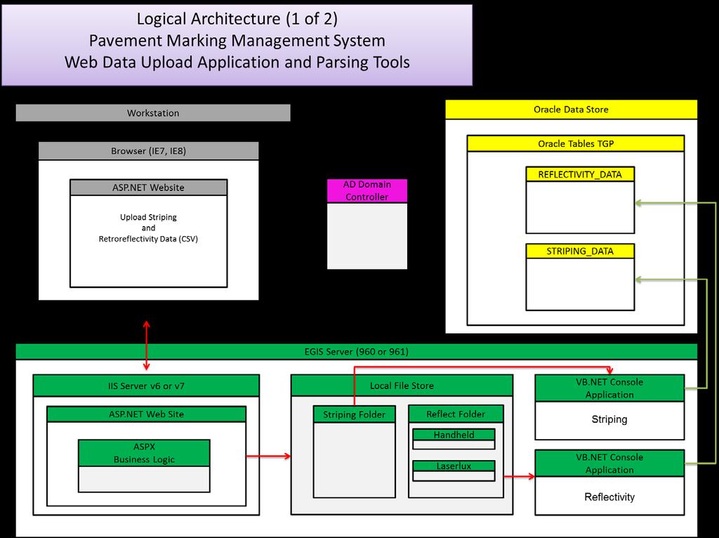
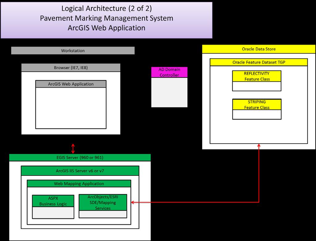
6 Table of Contents Chapter 1 Introduction...1 Chapter 2 Findings by Task...3 Task 1.A PMMT Implementation Plan...3 For the PMMT to become Operational, the Following Steps Need to be Completed....3 Future Research...3 Strategy towards Full Implementation...3 Task 1.B PMMT Data Flow and Process...5 Task 2 Handheld Retroreflectivity Data Collection Protocol...5 Introduction...5 Recommended Protocol...5 Task 3 Initial PMMT Training and Outreach...7 Meeting Locations...7 Meeting Information...8 Meeting Feedback...8 Tasks 4, 5, and 6B Operational PMMT and Data Portal...9 Minnesota DOT Pavement Marking Management System Submitting Data...10 Minnesota DOT Pavement Marking Management System Web Application...16 Task 6A Investigate Automation of Striping Data...37 Task 7 District Training...41 Chapter 3 Conclusions...42 Appendix A PMMT Data Process/Flow Chart Appendix B MnDOT Data Logging System (DLS) Specifications
7 List of Figures Figure 1. Handheld Retroreflectometer...5 Figure 2. Data Collection Points on a Multi-lane Roadway...6 Figure 3. Example Plot from Skip Line Controller Data (Plotted by Truck Speed)...37 Figure 4. Paint Coverage Areas...38 Figure 5. Magnified Areas for Paint...39 Figure 6. Areas with Application Speed over 15 mph...40
8 Executive Summary Providing visible pavement markings at the center and edges of roadways are critical to public safety, helping to prevent accidents by delineating traffic lanes more clearly and providing information to drivers about lane changing and passing opportunities. MnDOT faces considerable challenges in maintaining visible pavement markings across the state transportation network given the damage these markings receive from winter maintenance activities and wear due to vehicular traffic. Managing pavement marking visibility has the potential to reduce MnDOT costs, improve pavement marking performance through selecting better materials, and in return provide a more efficient and safe driving experience for the traveling public. This project accomplished a major MnDOT objective which is the implementation of a pavement marking management web application tool. Based on a previous effort Developing and Implementing Enhanced Pavement Marking Management Tools for MnDOT Phase I, this Phase II work delivered the critical implementation efforts needed to facilitate the usage and effectiveness of the Pavement Marking Management Tool (PMMT). Implementation of the PMMT begins with data, more specifically, pavement marking retroreflectivity and striping data which is incorporated into an ORACLE database. Retroreflectivity provides a measure of the pavement markings visibility under dark conditions on unlighted roadways. The striping data provides information relative to when, where, and how each roadway was painted which supports an analysis of performance over time. Since both MnDOT staff and their Contractors measure retroreflectivity and install markings on MnDOT roadways, implementation of the PMMT included simplifying the process of collecting and submitting data, storing these data, and in providing staff access to the data to turn it into useful information for analysis. Training was an essential implementation activity for the PMMT and was divided up into an initial set of training sessions and final training. The initial training was conducted for central office, District 6, and Metro District staff and provided feedback on how the field data (retroreflectivity and paint) would be submitted to the PMMT and the quality control process in place to address errors. Based on this feedback, the research team worked with both IT and geographic information system (GIS) staff to finalize all input automation processes, the data portal, and the operational PMMT. The final training consisted of computer based instruction on the use of the fully operational PMMT and was conducted at 5 locations across the state including staff from Central Office and each district. As the numerous screen-shots within this report show, implementation of the web based PMMT provides MnDOT staff with the ability to input, organize, query, and most importantly turn pavement marking data into useful information. In summary, the graphic PMMT enables managing this critical safety feature at the roadway, district, and statewide level which will result in data driven decision making and ultimately a more efficient, effective, and safer roadway network for all roadway users.
9 Chapter 1 Introduction The objective of the research is to fully implement the recently developed Pavement Marking Management Tool by incorporating retroreflectivity and striping data (MnDOT and contractors), and simplifying the process of data collection, storage, and analysis. As part of achieving full implementation, the researchers provided training to MnDOT central office staff and staff in each of the districts. Improved pavement marking management has the potential to reduce MnDOT s costs, improve pavement marking performance, and in return provide a more efficient and safe driving experience for the traveling public. This technical memorandum presents project findings by tasks, which are noted below. Task 1.A Review the recommendations from the previous project recently completed for MnDOT for full implementation and develop strategies to address the required steps to move towards full implementation. A data schema of the recently developed MnDOT Pavement Marking Management Tool will be sent to MnDOT for approval. The research team will meet with the project TAP (including IT staff) to discuss the findings and finalize the implementation plan. Task 1.B Develop data flow process from central office, districts, striping crews, and pavement marking contractors to the ORACLE database for use by the pavement marking management web-based tool. The team will develop the processes in coordination with MnDOT enterprise geographic information system (EGIS) staff to meet the database model standards and requirements. MnDOT EGIS staff will still run the RLC process after delivery of formatted data and append records to the ORACLE database. The existing Pavement Marking Management Tool will be modified to reflect the current migration by MnDOT to ARCGIS 9.3. Task 2 Develop data collection protocols for using the handheld (LTL-X) devices available to the districts. The data collection protocol will define sampling rates, collection method, and frequency. The research team will work with central office and district staff to address the data collection needs, constraints in terms of time and personnel, and format. Task 3 Initial training: work with central staff, district 6 and metro district to conduct PMMT training and also get feedback regarding automation tasks. Task 4 Work with IT and geographic information system (GIS) staff to develop processes and tools to allow for automated input of pavement marking data into the ORACLE tables developed in Phase I of this project. This task will involve both central office pavement marking staff, and GIS and IT personnel. The research team will use the final implementation plan developed in Task 1 to guide the tools development process. At the conclusion of this task, the recently pavement marking management web-based developed by CTRE for MnDOT should be populated with van collected retroreflectivity data from 2007 and 2008 (additional data collected using handheld by the district staff and paint information from central striping will also be considered). Task 5 Work with the pavement marking contractors and MnDOT to develop a methodology to allow for proper data input utilizing the web-based process developed in Task 1.B (pavement 1
10 Task 6 Data Automation Task: Task 6.A Investigate the use of monitoring technology (SkipLine controllers are used on two paint trucks in MN) to automate the collection of paint information and develop guidelines for proper data format to be followed by all districts. Task 6.B Work with district staff to automate data entry/interface to the pavement marking tool for both retroreflectivity (Handheld LTL-X devices) and paint information. Task 7 Training: work with the central office and the remaining districts (6 districts) to conduct training on the use of the PMMT and also gain feedback regarding data collection and automation processes. Task 8 - Technical Memorandum The technical memorandum summarizes project findings and discuss additional future steps to enhance pavement marking decision making and performance. 2
11 Chapter 2 Findings by Task Task 1.A PMMT Implementation Plan Review the recommendations from the previous project recently completed for MnDOT for full implementation and develop strategies to address the required steps to move towards full implementation. A data schema of the recently developed MnDOT Pavement Marking Management Tool will be sent to MnDOT for approval. The research team will meet with the project TAP (including IT staff) to discuss the findings and finalize the implementation plan. The recommendations from the previous Phase I project were as follows: For the PMMT to become Operational, the Following Steps Need to be Completed 1. Build ORACLE Tables (this will be completed by CO EGIS based upon the standard format and naming convention established for the PMMT. 2. Develop retroreflectivity data flow requirements. a. Data Sources: i. Laserlux data from central office (does not currently include GPS) ii. Handheld data from districts (some of this will not have GPS) b. Data Formatting putting the above data within the standard PMMT format for location, pavement marking and installation information. This will be completed by CO-OTSO staff. c. Data Submittal Development of the handshake for data transfer from CO- OTSO to the web server (CO-EGIS). d. Location Formatting CO-EGIS will use the Route Location Converter (RLC) to convert location information into the MnDOT GIS web server format. 3. Implementation Determine web server needs, number of users, and other features/business rules to support access to the PMMT. Future Research Further enhancements to the PMMT will include: 1. Striping Data - Incorporation of striping data from both CO and Contract Striping which will give staff the ability to match marking performance with installation information. 2. Standardize Handheld Data Collection - Developing data collection protocols for district staff to use when colleting retroreflectivity information using the handheld devices. 3. Standardize Mobile Data Collection Identify opportunities to improve the Laserlux data in terms of data quality (less variability), location information (GPS), and incorporation of this information into the PMMT database. Strategy towards Full Implementation The following work plan addresses the next steps and future research identified within the Phase 1 report. 3
12 Task 2 Develop data collection protocols for using the handheld (LTL-X) devices available to the districts. The data collection protocol will define sampling rates, collection method, and frequency. The research team will work with central office and district staff to address the data collection needs, constraints in terms of time and personnel, and format. Task 3 Initial training: work with central staff, district 6 and metro district to conduct PMMT training and also get feedback regarding automation tasks. Task 4 Work with IT and GIS staff to develop processes and tools to allow for automated input of pavement marking data into the ORACLE tables developed in Phase I of this project. This task will involve both central office pavement marking staff, and GIS and IT personnel. The research team will use the final implementation plan developed in Task 1 to guide the tools development process. At the conclusion of this task, the recently pavement marking management web-based developed by CTRE for MnDOT should be populated with van collected retroreflectivity data from 2007 and 2008 (additional data collected using handheld by the district staff and paint information from central striping will also be considered). Task 5 Work with the pavement marking contractors and MnDOT to develop a methodology to allow for proper data input utilizing the web-based process developed in Task 1.B (pavement marking installation information) into the MnDOT Pavement Marking Tool. Task 6 Data Automation Task: Task 6.1 Investigate the use of monitoring technology (SkipLine controllers are used on two paint trucks in MN) to automate the collection of paint information and develop guidelines for proper data format to be followed by all districts. Task 6.2 Work with district staff to automate data entry/interface to the pavement marking tool for both retroreflectivity (Handheld LTL-X devices) and paint information. Task 7 Training: work with the central office and the remaining districts (6 districts) to conduct training on the use of the PMMT and also gain feedback regarding data collection and automation processes. 4

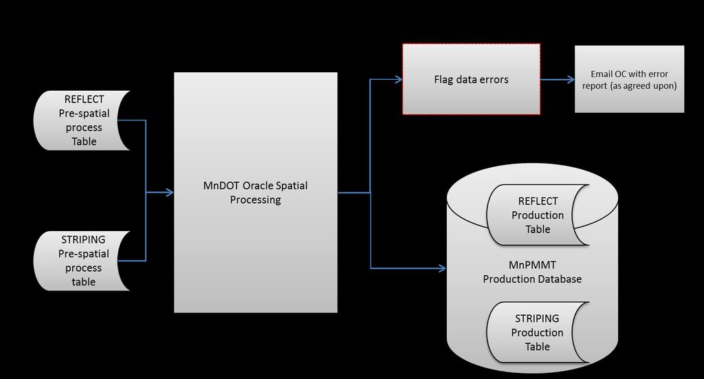
13 Task 1.B PMMT Data Flow and Process The research team developed PMMT data flow processes from central office, districts, striping crews, and pavement marking contractors to the ORACLE database for use by the pavement marking management web-based tool. These were developed in coordination with MnDOT EGIS staff to meet the database model standards and requirements. The developed diagrams, flow processes, and schema s are included within Appendix A. Task 2 Handheld Retroreflectivity Data Collection Protocol Introduction Pavement marking retroreflectivity condition information is collected by MnDOT staff using both handheld and mobile (van) equipment. This information will serve as the primary pavement marking performance metric within the MnDOT Pavement Marking Tool (a GIS based tool to view and query condition information). Specific to the handheld devices (see Figure 1) a protocol for data collection is needed to ensure consistency on when, where, and how the field data are obtained. This effort is identified within the project scope as follows. Recommended Protocol Figure 1. Handheld Retroreflectometer This protocol is specific to the collection of network level pavement marking retroreflectivity information to be incorporated within the MnDOT pavement marking database. The research team investigated various sources to develop this recommended protocol. These included current ASTM practices, Iowa DOT data collection protocol, and other available information. This information is summarized below: 5
14 Sampling Frequency: ASTM Practice: The currently proposed practice calls for taking 20 retroreflective readings equally distributed over 400 feet within a 2 mile segment. This level of sampling is designed for compliance based testing on new pavement markings. Iowa DOT Practice: The Iowa DOT protocol collects 12 readings equally distributed over 160 feet within a 4 and/or 5 mile segment. This level of sampling is intended for network level pavement marking management. Proposed MnDOT Practice: In an effort to balance consistency, objectivity, and field data collection time, the following three options were considered. Method 1 Collect 20 readings equally distributed over 400 feet within a 4 mile segment. Method 2 - Collect 10 readings equally distributed over 200 feet within a 2 mile segment. Method 3 - Collect 5 readings equally distributed over 200 feet within a 2 mile segment. Each method tries to balance the impact of variability over a segment versus the time required to collect the data. Of the three, the research team recommends Method 1 which results in a more representative value (given that we are collecting 20 readings over 400 feet) and minimizes crew exposure and time. The sampling frequency was modified to be Recommendation: Method 1 but adjusted for MnDOT skip line spacing criteria (16 readings over 400 feet within a 4 mile segment) - see Figure 2. For skip lines take 2 measurements per skip for 8 consecutive skips. For edge lines take 16 measurements approximately 25 feet apart. x x x x x x x x x x x x x x x x x x x x 400 feet Figure 2. Data Collection Points on a Multi-lane Roadway 6
15 Data Collection Procedure: When Annually during the months of April, May and June (prior to the paint season). This time frame allows the Districts/Central Striping to utilize the retroreflectivity information to plan for their summer paint season. Where For consistency over time, the research team recommends collecting the data at the same locations each year (using milepost markers as a reference). Accuracy and efficiency can be improved by creating a database containing route and milepost locations where data are to be collected. These databases should be uploaded into each handheld instrument by district. How The recommended field data collection process follows: 1. Calibrate the handheld instrument according to the manufacturers recommendations. 2. Locate the field sampling locations using the milepost marker. Care should be taken to select areas that are typical of the marking section, avoiding areas of paint tracking or contamination. 3. All measurements should be taken in the direction of travel (with the milepost). On the centerline of undivided highways, measurements should be made in both directions of travel. If two center marking lines exist, alternate between each line and by travel direction. 4. On all traffic lines take the reflectivity reading centered on the line. On edge lines take 16 equally spaced readings within the 400 foot sampling area regardless of the condition of the line. On lane lines, take 2 readings on each skip for 8 consecutive skips, see Figure Data entry for handheld instrument a. Set the device to average based on 16 readings. b. Select route and milepost from the pre-loaded list. c. Enter direction of travel 1 with milepost and 2 against the milepost. On twolane roadways, the yellow centerline direction is always recorded as a 1. d. Select the line type to be measured. e. Select the marking material type (if known). f. Take retroreflective readings using the defined procedure. Task 3 Initial PMMT Training and Outreach This included working with central staff, district 6 and metro district to conduct initial PMMT training and to receive feedback regarding automation tasks. A summary of the two training sessions follows. Meeting Locations Training and feedback sessions were held as follows: District 6 (Rochester) This meeting was held on March 10 th, 2010 with 12 participants (11 from District 6 and 1 from District 7) which included a mix of positions (Central Office, District technical, and District field staff). Metro District (Arden Hills Training Facility) This meeting was held on March 11 th, 2010 with 7
16 18 participants who included a mix of positions (Central Office, District technical / field / and management staff). Meeting Information Each training/feedback session included a presentation by CTRE staff covering the following topics: 1. Pavement Marking Practices a. Introduction b. Challenges c. Retroreflectivity d. MnDOT Pavement Marking Practices i. Material Selection ii. Equipment iii. Operations iv. Management 2. Pavement Marking Retroreflectivity Versus Safety 3. Data Collection 4. MnDOT Pavement Marking Management Tool a. Overview b. Data Structure c. Demonstration i. Data Input ii. Tool Operation iii. Reports and Queries iv. Hands-on Meeting Feedback Participant feedback and comments is summarized below: A. Feedback/background regarding MnDOT Pavement Marking Practices: District 6: Interstate, 4-lane, and new construction is typically epoxy with an expected life of around 4 years. Interstate lane line is tape. Maintain epoxy for two cycles then apply latex. Latex is 20 mil initially and around 12 mil maintenance. Two-lane roads are usually latex and are painted each year. District has experimented with 6 stripes based on crash data. On new seal-coat, the district experimented with a double epoxy being applied one week after installation. Metro District: Operate both latex and epoxy trucks. Latex truck is equipped with a skip line controller (allows for automated capture of striping data). 8
17 Significant challenges due to traffic and roadway conditions. Have a modified paint carriage which is very effective for bead placement around curves. B. Feedback/discussion on MnDOT Data Collection Protocol Discussed the data collection protocol as follows: o For a 4 mile segment, select a 400 foot segment which begins at a milepost marker. For this segment: Take 2 measurements per skip for 8 consecutive skips, and On edge line, take 16 measurements approximately 25 feet apart. o The group discussed this process from a field staff/efficiency perspective. The question was specific to the order each line would be measured as you travel along the segment. For example, should staff take readings on an edge line first then travel back to do the center-line or should they read both the edge and center line at the same time as they travel down the road. After this discussion, the group felt that MnDOT should develop a field data collection procedure which provides guidance on the overall field data collection process. Demonstrated the use of the LTL-X handheld retroreflectivity device. C. Feedback/discussion on MnDOT Pavement Marking Management Tool (PMMT) The districts would like to use the tool to compare the performance of different products and installation methods. A discussion followed where the importance of collecting retro data, installation information, and material type is crucial in meeting this need. Add meta-data to the information e.g. what does I35_E mean? Provide a distinction between Mobile and Handheld retro data on the map. Modify the tool to allow each district to view their district data rather than start with the statewide map view. Define retroreflectivity ranges e.g. green = good. Arrange the graph data by date from old (left) to new (right) Investigate possibility of combining both white and yellow data within one table (might be problematic given that each color has a different retroreflectivity threshold). The research team will work with the technical panel to address this issue. Discussed minimal data requirements for contractor applied paint and how this fits within the MnDOT PMMT. Discussed the feasibility of developing a planning function which would allow the districts and CO striping to develop pavement marking plans (where, material type, estimated cost, time frame). This is outside the scope of this current project but the research team will provide a write-up on this concept as discussed and will present this to the technical panel for further discussion. Tasks 4, 5, and 6B Operational PMMT and Data Portal These tasks covered the development of the PMMT tool and a data collection portal for paint and retroreflectivity data. The following user manuals cover these tools. 9
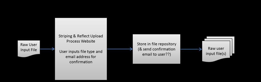
18 Minnesota DOT Pavement Marking Management System Submitting Data 1. The main web portal for PMMT allows you to enter the data uploading application or interactive web map application. 10
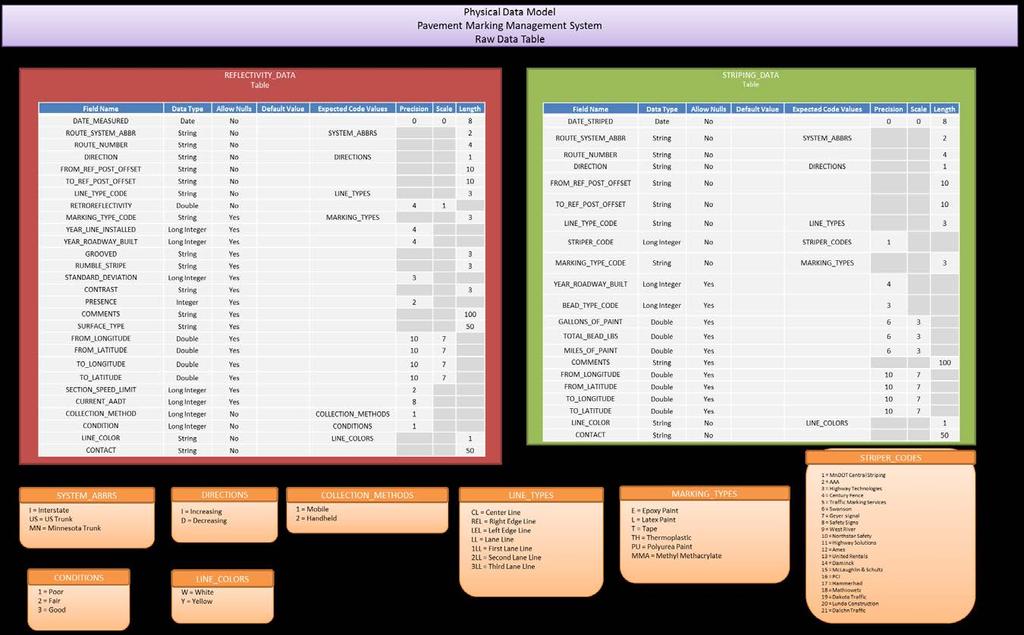
19 2. Select the Upload Striping and Retroreflectivity Data link at the top of the site to enter the data uploading site. 3. The upload site was requires that the Silverlight browser plug-in be installed. If your computer does not already have Silverlight installed you should be prompted to install it before the site will display properly. Note: Administrator or installer privileges may be required to install Silverlight software. 4. The left hand side of the data upload site has some helpful files available to assure that the correct data and format are submitted for processing. a. Retroreflectivity Input Requirements (pdf) This file indicates the field requirements and data structure required to submit a retroreflectivity data file successfully through the data upload portal. i. Indicates required fields, data types, and code values used for specific fields. 11
 This file indicates the field requirements and data structure required to submit a striping data file successfully through the data upload portal. i. Indicates required fields, data types, and code values used for specific fields.")
20 b. Retroreflectivity File Template (Excel) this file is an Excel template that provides the required field restructure necessary to upload a retroreflectivity data file. c. Striping Input Requirements (pdf) This file indicates the field requirements and data structure required to submit a striping data file successfully through the data upload portal. i. Indicates required fields, data types, and code values used for specific fields. d. Striping File Template (Excel) this file is an Excel template that provides the required field restructure necessary to upload a striping data file. 5. You may only submit a single data file at a time. Currently the only accepted format is a comma-delimited CSV file. The Excel template can be saved as a CSV in Excel. 12

21 6. From the Upload site select the Browse button and select the CSV data file you want to upload. 13
22 7. Select the specific data file type being uploaded and enter a valid address that the system can respond to. The example below is an upload of a retroreflectivity data file containing Laserlux data only. 14


23 8. If submitting Striping data you will also be presented with a drop-down list that indicates where the data originated. 9. When processing begins you will receive a wait screen and if processing has completed successfully a prompt will display. 15

24 10. The message you receive will indicate how many records were processed and may have a couple of file attachments indicating record errors that have occurred and a description as to why they occurred. 11. IMPORTANT: The records contained within these attachments are only of records that were indicated as having processing issues. If these records are able to be corrected, only submit these records and not the original data file again. Minnesota DOT Pavement Marking Management System Web Application 1. The main web portal for PMMT allows you to enter the interactive web map application. 16
 i. Magnifier j. Measure k.")
25 2. Select the Interactive Pavement Marking Map link at the top of the site to enter the web map site. 3. On the top right-hand portion of the site the common map controls are available. In order from left to right. a. Zoom In b. Zoom Out c. Pan d. Full Extent e. Back Extent f. Forward Extent g. Map Identify h. Chart (custom tool described at 6) i. Magnifier j. Measure k. Show Overview Map 17

26 4. The Chart Query pane on the left side of the website allows the user to specify what type of information is shown in the map window. These selections affect the Chart tool output and other query results. 18
27 a. The District drop-down list allows the choice of all data or only data within the bounds of the district selected. b. The Collection Method radio list allows the choice of all data or only the selected collection method. c. The Line Type drop-down list allows the choice of a single paint line type to view. 19
28 d. The Direction radio list allows the choice of all or only the selected route direction. e. The Year drop-down list allows the selection of a single year of data to view. f. The display below the year drop-down list shows the number of miles currently displayed on the map and the retroreflectivity quality based on the criteria selected. i. The example below shows that miles of roadway are within the good range of retroreflectivity readings, miles are in the fair range, and miles are considered to be poor with a retroreflectivity reading below
29 5. The Map Contents pane controls the viewable map layers. Note: Only one Pavement Marking layer (Retroreflectivity or Striping) can be displayed on the map at a time. When either layer is selected the other layer is automatically unselected. a. Currently selected map layer Retroreflectivity can display retroreflectivity values for both white and yellow line markings. 21
30 b. Map Contents the Striping layer shows the line marking types by color. i. Current selection criteria shown; white edge lines (REL), striped by either DOT maintenance crews or by private contractors in all directions of travel for data currently loaded from 2009 in all Minnesota DOT districts. 22

31 6. Selecting the Chart tool from the tool bar (circled in red), the user can select a retroreflectivity line from the map. This generates a bar chart for reflectivity vs. date to visually see how pavement markings are performing over time. a. As an example, a retroreflectivity line was selected on MN5 near reference post 43 23

32 b. The resulting chart from the Chart tool selection made above at MN5 near reference post

33 7. The Identity tool is used to look at specifically selected location information of all available map layers near the point chosen. 25

34 a. Identity tool after selecting the map layer to view, clicking the down arrow on the popup bar will display the underlying data record for the selected location. 26
35 8. Near the top left corner of the website is Select By Attribute. This is a querying tool that allows the user to specify attributes and build a Structured Query Language (SQL) like statement to pull records out of the underlying map layers for further analysis. a. Select a Layer to be queried, in this case the layer Retroreflectivity is chosen. 27
36 b. Select By Attribute Continue building a query by selecting an Attribute from the drop-down list and an operator from the Operation drop-down list. 28

37 c. Select By Attribute With an attribute selection made the user has the option to manually input the query Value or use the Get Sample Values to populate a dropdown list with values taken from the actual layer data for the selected attribute. 29
38 d. Select By Attribute Once all the Attribute Selections have been made the user clicks on the Add to Query Expression button to add the SQL statement to the Query Expression textbox. If additional conditional statements need to be added to the SQL statement the user can select the appropriate button (AND, OR, NOT) to append it to the statement within the textbox. Once the SQL statement has been constructed the user can click the button Query full extent to run the SQL query against the selected map layer data. i. EXAMPLE: (ROUTE_NUMBER = '5' AND ROUTE_SYSTEM_ABBR = 'MN' AND RETROREFLECTIVITY < 100) ii. NOTE: Criteria selected in the Chart Query pane also affect the available data set. Based on the selections in that pane only white edge lines in the increasing lane direction will be selected by the query as well. 30

39 e. Select By Attribute When the query completes it will populate the RESULTS pane on the left side of the webpage. 31


40 f. Select By Attribute Clicking the double arrow will move the Results pane into the main window allowing the user to expand the table view. 32

41 g. Results The results can be viewed or saved to an Excel file by clicking on the Export to Excel button. 33

42 h. Results The query results presented as an exported Excel file. 34

43 9. Select By Attribute Query results can also be generated using the geometry tools located at the bottom of the Select By Attribute window. a. Shown above the rectangle geometry selection tool is selected and a box is drawn by the user around an area of interest. 35

44 b. Select By Attribute The selection is highlighted and the data resulting from the selection is populated into the Results pane and can be viewed or exported in the same manner as doing a SQL based query. 36
 the data were plotted for review as shown in Figure 3. Google Figure 3.")
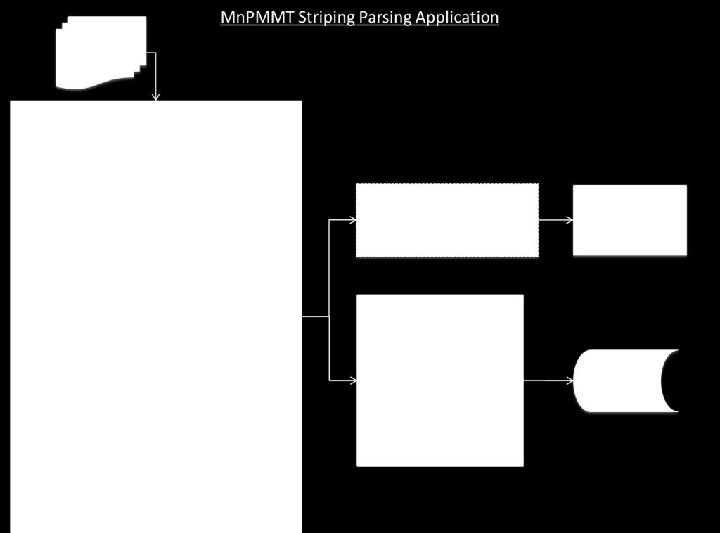
45 Task 6A Investigate Automation of Striping Data Skip Line Format - The research team visited the Metro paint crew during Phase I of the project and collected a sample of skip line striping data from the 2006 and 2007 seasons. Since some of the data included GPS readings (latitude, longitude) the data were plotted for review as shown in Figure 3. Google Figure 3. Example Plot from Skip Line Controller Data (Plotted by Truck Speed) New data were obtained from Central Striping from the Metro truck equipped with the Skipline controller. The next three figures show some of the results. The Skipline controller keeps data on quantities (paint and beads), location (by latitude and longitude if activated), type of line by color, environmental data (road temperature, ambient temperature, and humidity), and other data. Currently, the program does not support all the striping data information required by the PMMT, but with some minor modifications this data can be provided by the operators and saved into the database. 37

46 Metro district Skipline data for where the truck painted. As the map shows, the Metro District truck applied paint in the NE, SW, and metro areas. Figure 5 provides a magnification of paint activities and Figure 6 shows locations where the paint was applied at travel speeds over 15 mph. Figure 4. Paint Coverage Areas 38

47 Figure 5. Magnified Areas for Paint 39
 which")
48 Figure 6. Areas with Application Speed over 15 mph Based on the results from this investigation, MnDOT s Office of Traffic, Safety and Technology developed specifications for a Data Logging System (DLS) which establishes the data requirements and formats to transfer applied striping data from data logging devices into MnDOT s PMMT database in an automated fashion. This specification is required to be used by all MnDOT striping contractors. MnDOT is also planning to equip their trucks over time with the same system. The specifications are included within Appendix B. 40
49 Task 7 District Training Computer based training on the use of the PMMT tool and handheld retroreflectometer equipment was provided by the research team to relevant MnDOT staff at a number of locations across the state, including: November 22 D6 and D7 in Rochester November 23 D1 in Duluth November 29 Metro District and CO at Arden Hills AM & PM sessions (2 sessions) December 7 Districts 3 and 8 in St Cloud December 8 Districts 2 and 4 in Detroit Lakes There were between 10 and 14 people in each session (not including CO Traffic or CTRE staff). The comments and feedback were very positive and MnDOT (Mitch Bartelt) kept track of some of the comments and requests for changes. Suggestions that were outside the current scope were discussed by CO Traffic. The training agenda included the following: 1. Introductions and project background 2. How to collect manual retroreflectivity data? (data collection protocols) 4. How to submit data? 5. Pavement Marking Management Tool (PMMT) operations 6. Handheld LTL-X demonstration and hands-on training 7. Questions and answers 41
50 Chapter 3 Conclusions The research team, in cooperation with MnDOT staff, developed and implemented a web-based GIS tool to help the department to manage pavement marking retroreflectivity to ensure better service for the users. Managing pavement marking visibility has the potential to reduce MnDOT costs, improve pavement marking performance through selecting better materials, and in return provide a more efficient and safe driving experience for the traveling public. Implementation of the PMMT begins with data, more specifically, pavement marking retroreflectivity and striping data which is incorporated into an ORACLE database. Retroreflectivity provides a measure of the pavement markings visibility under dark conditions on unlighted roadways. The striping data provides information relative to when, where, and how each roadway was painted which supports an analysis of performance over time. Since both MnDOT staff and their Contractors measure retroreflectivity and install markings on MnDOT roadways, implementation of the PMMT included simplifying the process of collecting and submitting data, storing these data, and in providing staff access to the data to turn it into useful information for analysis. Now that the PMMT is fully implemented, the MnDOT can look into further enhancement of the tool by adding one or more of the following functionalities. Some of those options were suggested by staff during the district training that took place during the project. Project planning tool: This will allow the districts to build their paint program (location, materials, lines, quantities, and cost) utilizing the existing information in the tool. A GIS map with detailed information will be created to allow Central Painting to identify the required work and schedule the crews to implement. Data mining: This will help MnDOT staff (Central office or districts) to mine the PMMT data to look at pavement marking performance by material, line type, installation type (grooved vs. surface applied) on a state-wide basis or by region. Enhance the data: This requires the additional of more information to the PMMT to enhance its analytical capabilities. Information such as winter weather maintenance operations, pavement type and condition, traffic to help develop better pavement marking selection tools and performance metrics. 42
51 Appendix A PMMT Data Process/Flow Chart
52 A-1

53 A-2

54 A-3
55 A-4
56 A-5
57 A-6
58 A-7

59 A-8

60 A-9
61 A-10
62 A-11
63 Appendix B MnDOT Data Logging System (DLS) Specifications
64 (2582) PERMANENT PAVEMENT MARKINGS Use SP (EPOXY PAV T. MARKINGS (FREE OF TOXIC HEAVY METALS)), SP (HIGH SOLIDS WATER-BASED PAINT), and SP (DROP-ON GLASS BEADS) with this writeup. If the job is a signal only, then check to see if new pavement markings are shown on the plan or are in the Division SS. If there are new pavement markings on the signal job but there is no pay items on the plan for them, then only use S-.1 thru S-.4. REVISED 2/7/08 SP The provisions of MnDOT 2582 are hereby modified and/or supplemented with the following: The provisions of MnDOT are hereby deleted and replaced with the following: A Preformed Plastic Markings for Permanent Traffic Lane Delineation and Legends B Epoxy Resin Pavement Markings (Free of Toxic Heavy Metals) C High Solids Water-Based Traffic Paint D Drop-On Glass Beads Qualified materials can be found on MnDOT's Qualified Products List on the Office of Traffic, Safety and Technology website. Other materials may be used on a provisional basis as detailed in the QPL process and as approved by the Engineer. Type of material used will be as specified by Contract Documents. MnDOT A2 is hereby deleted. The following is hereby added to MnDOT B, Application: Any pavement markings to be grooved in shall be placed in accordance with manufacturer s instructions. MnDOT C3 is hereby deleted and replaced with the following: Provide pavement markings meeting the following minimum initial pavement marking retroreflectivity when tested using 30 m geometry in accordance with ASTM E 1710: Table Minimum Initial Pavement Marking Retroreflectivity White Yellow Tape 600 mcd/sq. m/lux 500 mcd/sq. m/lux Epoxy 300 mcd/sq. m/lux 200 mcd/sq. m/lux Latex 275 mcd/sq. m/lux 180 mcd/sq. m/lux Use below language when the project is at least 1 centerline mile in length. B-1
65 Mobile Retroreflectometer Measurements (MRM) Retroreflectivity measurements of longitudinal markings shall be provided by the Contractor utilizing an independent Contractor using a vehicle-mounted mobile retroreflectometer utilizing 30 meter CEN geometry in accordance with ASTM E (Standard Test Method for Measurement of Retroreflective Pavement Markings Materials with CEN-Prescribed Geometry Reflectometers). The retroreflectometer shall be calibrated no less than twice a day in accordance with the operating manual and calibration guide for the particular machine and vehicle. Measurement shall consist of the average retroreflective readings and standard deviations over 1 mile intervals (or over the length of the line if shorter than 1 mile) for each type of pavement marking placed under this contract. The measurement report will include: 1. State Project Number, 2. Date and time of data collection, 3. The highway number with the beginning and ending reference points of data collection rounded to the nearest thousandths of a mile and the beginning and ending coordinates determined by a Global Positioning System receiver with 3 meter accuracy, including the direction of travel in terms of increasing or decreasing reference points, 4. Which line is being read (LEL Left Edgeline, REL Right Edgeline, CL, Centerline, LL Lane Line Skip, 1LL left most LL in multilane, 2LL second to left most LL in multilane, etc), 5. The 0.1 mile station averages and standard deviations, 6. A summary of the average retroreflective readings in one mile increments. The measurement report will in the form of an electronic database file, or delimited text file, containing all raw data collected. The electronic file must also contain a summary that is capable of being directly uploaded to the Department s Pavement Marking Management Tool (PMMT) database. The data shall be submitted and accepted into the PMMT at the following intranet website: hppt://gisservices/mnpmmt/. A printed record of the summary shall also be provided to the Engineer at the Engineer s discretion. The evaluation of retroreflectivity will be conducted at least 14 days after installation. Excess beads or reflective elements must not be visible before the retroreflectivity testing is conducted. Data shall be collected when pavement and markings are dry, clean and no visible moisture is on the road surface. These criteria define initial pavement marking retroreflectivity values. Centerline markings shall be measured in both directions. Other longitudinal markings shall be measured in the direction of intended vehicular travel. Any replaced markings will also need to be evaluated at no additional cost per this special provision. The Mobile Retroreflectometer Measurements, including but not limited to materials, equipment, labor and time, will be measured based on the Linear Foot. The Linear Foot will be measured for the distance travelled by the mobile retroreflectometer as it measures the retroreflectivity of the pavement marking. This assumes one laser instrument on one van that will read one line with each pass. For a one mile section of two-lane, two-way roadway this would need four (4) passes First Direction: REL and CL, Second Direction: REL and CL - equating to linear feet. No payment for pavement markings shall be made until the evaluation of retroreflectivity is complete and the work accepted by the Engineer. B-2
66 MnDOT F is hereby deleted and replaced with the following: Remove and replace, or repair, pavement markings not meeting the minimum initial pavement marking retroreflectivity values in accordance with Table , as approved by the Engineer at no additional cost the Department. If the retroreflectivity deficiency is no greater than 20 percent, the Engineer may accept the work at a unit price reduced by the percent of retroreflectivity deficiency. MnDOT G is hereby deleted and replaced with the following: Construction Striper Operations Daily Log Contractors applying pavement markings for MnDOT under a contract are required to fill out the "Construction Striper Operations Daily Log" form which is shown in the special provisions and as approved by the Engineer. AND/OR Use when project includes liquid markings and is at least 1 centerline mile in length. The Construction Striper Operations Daily Log is required for Tape systems. Striper Computerized Data Logging System for Liquid Markings (DLS) The pavement marking device shall have an onboard monitoring system for the purpose of managing the amount of striping materials being applied to a surface. Data shall be collected for any pavement marking application of 300 feet (drive length) or greater. The following data shall be included in the documentation from the DLS: 1. State Project Number, 2. For every highway marked, the highway number with the beginning and ending reference points rounded to the nearest thousandths of a mile and the beginning and ending coordinates determined by a Global Positioning System receiver with 3 meter accuracy, including the direction of travel in terms of increasing or decreasing reference points, 3. Date, and beginning and ending time of application, 4. Vendor and product (binder and reflective material), 5. Lot number(s) of product used, 6. Striping contractor (striper code), 7. Designation of the marking being applied (LEL Left Edgeline, REL Right Edgeline, CL - Centerline, LL Lane Line Skip, 1LL left most LL in multilane, 2LL second to left most LL in multilane, etc), 8. Width of marking being applied, 9. Presence of groove or rumble strip (if pavement marking is being installed on top of, begin and end points of groove or rumble will be recorded by GPS), The following data shall be reported as an average for each drive mile installed: 10. Application vehicle speed to the nearest 0.1 MPH, 11. Weight (LBS) and/or volume (GAL as measured through a positive displacement pump mechanism or flow meter) of liquid material(s) used by color, 12. Weight (LBS) of reflective material used, 13. Ratio of reflective material used (weight) per liquid material used (volume) reported as LBS/GAL, 14. Ambient air temperature (in degrees Fahrenheit), B-3
67 15. Road surface temperature (in degrees Fahrenheit), 16. Humidity (%), 17. The system shall record the average material application rates and film thickness calculated over the section striped, and This system shall be capable of storing data and exporting to the Department s Pavement Marking Management Tool (PMMT) and the data shall be submitted into the PMMT daily at the following web address: hppt://gisservices/mnpmmt/. A printed record of the data shall also be provided to the Engineer at the Engineer s discretion. The printed and electronic records shall be produced in their final form prior to the records being removed from the pavement marking equipment. The Contractor shall provide the Engineer the above records for all longitudinal non-handwork lines installed. The Contractor shall have equipment with functional DLS equipment that is operational, calibrated and in use during pavement marking operations. Pavement marking installation without the use of a DLS shall constitute unauthorized work under The Contractor shall provide the Engineer the DLS manufacturer s recommendations for equipment calibration frequency and provide certification that the equipment meets manufacturer s recommended calibration. A 100 foot distance shall be travelled prior to the start of pavement marking operations to verify the physical and electronic measurement of distance travelled is consistent. The Striper Computerized Data Logging System shall be incidental to permanent pavement marking operations for which no direct payment will be made. The provisions of MnDOT are hereby deleted and replaced with the following: BASIS OF PAYMENT Payment for pavement markings installed at Contract prices per unit of material shall be compensation in full for all costs incurred in materials, traffic control, installation, surface preparation, use of primers, in accordance to Contract documents or as approved by the Engineer. Payment for the retroreflectivity evaluated at Contract prices per unit shall be compensation in full for all costs incurred in materials, equipment, labor, traffic control and time in accordance to Contract documents or as approved by the Engineer. ITEM NO. ITEM UNIT Pavement Message (1) (2)... Each mm ( inch) width (3) (4) (2)... meter (linear foot) Crosswalk Marking - (2)... square meter (square foot) Mobile Retroreflectometer Measurements... linear foot (1) Specify Message (2) Specify Material (3) Specified Type of Line (Solid, Broken or Dotted) (4) Specify Color B-4
APPLICATION SPECIFICATION CONVENTIONAL PAVEMENT MARKING MATERIALS 3 MINUTE DRY ALKYD AND HIGH SOLIDS LATEX
 APPLICATION SPECIFICATION CONVENTIONAL PAVEMENT MARKING MATERIALS 3 MINUTE DRY ALKYD AND HIGH SOLIDS LATEX Values stated in the International System of Units SI apply only to projects to be constructed
Iowa Pavement Marking Management System: Initial Phases
 Iowa Pavement Marking Management System: Initial Phases Neal R. Hawkins Center for Transportation Research and Education Iowa State University 2900 S. Loop Drive, Suite 3100 Ames, IA 50010 hawkins@iastate.edu
SPECIAL SPECIFICATION 8625 All-Weather Traffic Markings
 2004 Specifications CSJ 6203-45-001, 6225-40-001 & 0045-02-031 SPECIAL SPECIFICATION 8625 All-Weather Traffic Markings 1. Description. This work will consist of furnishing and installing a wet reflective
OKLAHOMA DEPARTMENT OF TRANSPORTATION SPECIAL PROVISIONS FOR TRAFFIC STRIPE (MULTI-POLYMER)
") 856-1(a-g) 09 OKLAHOMA DEPARTMENT OF TRANSPORTATION SPECIAL PROVISIONS FOR TRAFFIC STRIPE (MULTI-POLYMER) These Special Provisions revise, amend, and where in conflict, supersede applicable sections of
856-1(a-g) 09 OKLAHOMA DEPARTMENT OF TRANSPORTATION SPECIAL PROVISIONS FOR TRAFFIC STRIPE (MULTI-POLYMER) These Special Provisions revise, amend, and where in conflict, supersede applicable sections of
Subject: Late Season/Cold Weather Temporary Pavement Markings
 Minnesota Department of Transportation MEMORANDUM Office of Traffic, Safety and Operations Office Telephone: 651-234-7377 Mail Stop 725 Fax: 651-234-7370 1500 West County Road B-2 Roseville, MN 55113 Date:
SPECIAL SPECIFICATION 6110 Reflectorized Pavement Markings with Retroreflective Requirements
 2004 Specifications SPECIAL SPECIFICATION 6110 Reflectorized Pavement Markings with Retroreflective Requirements 1. Description. Furnish and place reflectorized pavement markings of the types, colors,
SPECIAL SPECIFICATION 6003 Reflectorized Pavement Markings with Retroreflective Requirements
 2004 Specifications CSJ's 0005-11-003 & 6120-02-001 SPECIAL SPECIFICATION 6003 Reflectorized Pavement Markings with Retroreflective Requirements 1. Description. Furnish and place reflectorized pavement
GIS USE IN PAVEMENT MARKING AND SIGN MANAGEMENT: AN INTEGRATED APPROACH
 GIS USE IN PAVEMENT MARKING AND SIGN MANAGEMENT: AN INTEGRATED APPROACH Omar Smadi 1, Zachary Hans 2, and Neal Hawkins 3 ABSTRACT Geographic information system (GIS) technology is a key component of all
MINNESOTA DEPARTMENT OF TRANSPORTATION Engineering Services Division Technical Memorandum No T-02 October 30, 2014
 MINNESOTA DEPARTMENT OF TRANSPORTATION Engineering Services Division Technical Memorandum No. 14-11-T-02 To: From: Subject: Electronic Distribution Recipients Jon M. Chiglo, P.E. Division Director, Engineering
KANSAS DEPARTMENT OF TRANSPORTATION SPECIAL PROVISION TO THE STANDARD SPECIFICATIONS, EDITION 2015
 Sheet 1 of 10 KANSAS DEPARTMENT OF TRANSPORTATION SPECIAL PROVISION TO THE STANDARD SPECIFICATIONS, EDITION 2015 Delete SECTION 806 and replace with the following: SECTION 806 DURABLE PAVEMENT MARKING
Section 811. PERMANENT PAVEMENT MARKINGS
 811.01 Section 811. PERMANENT PAVEMENT MARKINGS 811.01. Description. This work consists of providing and applying retroreflective permanent pavement markings in accordance with the Michigan Manual on Uniform
SPECIAL SPECIFICATION 6149 Multipolymer Pavement Markings (MPM)
") 2004 Specifications CSJ s 0197-02-097, 0502-01-183 & 2374-03-068 SPECIAL SPECIFICATION 6149 Multipolymer Pavement Markings (MPM) 1. Description. Provide MPM on pavement surfaces shown on the plans to meet
2004 Specifications CSJ s 0197-02-097, 0502-01-183 & 2374-03-068 SPECIAL SPECIFICATION 6149 Multipolymer Pavement Markings (MPM) 1. Description. Provide MPM on pavement surfaces shown on the plans to meet
CHAPTER 16: TRAFFIC. In either situation, the plan must contain the detail for the interim pavement markings.
 CHAPTER 16: TRAFFIC ADVANCE WARNING SIGN SPACING The Advance Warning Sign Spacing for 0-30 mph has been reduced from 300 feet to 100 feet. This is more in line with the Federal MUTCD and accounts for more
Special Specification 6148 Inverted Profile Pavement Marking (Audible)
") Special Specification Inverted Profile Pavement Marking (Audible) 1. DESCRIPTION 2. MATERIALS Furnish and install an Inverted Profile Pavement Marking (Audible) that is hot applied to the pavement surface.
Special Specification Inverted Profile Pavement Marking (Audible) 1. DESCRIPTION 2. MATERIALS Furnish and install an Inverted Profile Pavement Marking (Audible) that is hot applied to the pavement surface.
INVESTIGATE THE ABILITY TO DETERMINE PAVEMENT MARKING RETROREFLECTIVITY
 INVESTIGATE THE ABILITY TO DETERMINE PAVEMENT MARKING RETROREFLECTIVITY Evaluate the Advanced Mobile Asset Collection (AMAC) Mobile Pavement Marking Retroreflectivity Measurement System Report prepared
Student Services & Classroom Addition
 SECTION 321723 - PAVEMENT MARKINGS PART 1 GENERAL 1.1 RELATED DOCUMENTS A. Drawings and general provisions of the Contract, including General and Supplementary Conditions and Division 01 Specification
AMENDMENTS Manual of STANDARD SPECIFICATIONS. Adopted by Standard Specifications Committee. Amendment. No. 7. Published by
 AMENDMENTS to 2012 Manual of STANDARD SPECIFICATIONS Adopted by Standard Specifications Committee Amendment No. 7 Published by Utah LTAP Center Utah State University 8305 Old Main Hill Logan UT 84322-8205
Development of a Presence Assessment Tool for Iowa s Pavement Marking Management System
 Development of a Presence Assessment Tool for Iowa s Pavement Marking Management System Final Report May 2011 Sponsored by Iowa Department of Transportation University Transportation Centers Program, U.S.
806 - DURABLE PAVEMENT MARKING SECTION 806 DURABLE PAVEMENT MARKING
 SECTION 806 DURABLE PAVEMENT MARKING 806.1 DESCRIPTION Prepare the pavement and apply the pavement markings as shown in the Contract Documents. When rumble strips are to be constructed on the project,
CHARLEVOIX COUNTY CHARLEVOIX COUNTY ROAD COMMISSION BOARD 2018 ANNUAL PAVEMENT MARKINGS BID
 CHARLEVOIX COUNTY CHARLEVOIX COUNTY ROAD COMMISSION BOARD 2018 ANNUAL PAVEMENT MARKINGS BID NOTICE TO BIDDERS The Charlevoix County Road Commission invites qualified contractors to bid on the annual requirement
KENTUCKY TRANSPORTATION CENTER
 Research Report KTC-11-22/SPR330-07-2I KENTUCKY TRANSPORTATION CENTER EVALUATION OF LONG-TERM PAVEMENT MARKING PERFORMANCE OUR MISSION We provide services to the transportation community through research,
Midcon August Presenters: Joseph Drahos and Shawn Blaesing-Thompson
 Midcon August 2015 Presenters: Joseph Drahos and Shawn Blaesing-Thompson Introduction Pavement Marking Management Task Force Look at most effective use of allocated paint program dollars Almost $7 million
ITEM 666 REFLECTORIZED PAVEMENT MARKINGS
 ITEM 666 REFLECTORIZED PAVEMENT MARKINGS 666.1. Description. This Item shall govern for furnishing and placing reflectorized pavement markings of the types, colors, shapes, sizes, widths, and thickness
2.0 MATERIALS AND REQUIRED PROPERTIES
 March 28, 2001 Supersedes January 28, 1993 SPECIFICATIONS NO. 1 PATTERNED PREFORMED POLYMER PAVEMENT MARKING TAPE WITH IMPROVED RETENTION OF REFLECTIVITY FOR LINES AND SELECTED SYMBOLS AND LEGENDS 1.0
Implementation of a Pavement Marking Management Program in Florida
 Implementation of a Pavement Marking Management Program in Florida NESMEA 2013 Presentation Outline Pavement Marking Information Current Re-Striping Determinations Mobile Retroreflectivity Unit (MRU) MRU
TXDOT SIGNING AND MARKINGS REVIEW OF MATERIALS & PRACTICES
 TXDOT SIGNING AND MARKINGS REVIEW OF MATERIALS & PRACTICES Table of Contents 1 2 3 4 5 6 7 Introduction Traffic Marking Specifications Traffic Marking Practices Signing Specifications Retroreflective Sheeting
WebGIFT: Modeling Intermodal Freight Transportation
 ROCHESTER INSTITUTE OF TECHNOLOGY AND UNIVERSITY OF DELAWARE WebGIFT: Modeling Intermodal Freight Transportation User Guide March, 2014 p.1 1. Contents 1. WebGIFT Overview... 3 2. Document Purpose... 3
Evaluation of Double Drop Beads Pavement Edge Lines
 Evaluation of Double Drop Beads Pavement Edge Lines By Dr. Jay K. Lindly (Principal Investigator) and Ms. Ayse Narci Department of Civil, Construction, and Environmental Engineering The University of Alabama
PAVEMENT MARKINGS. F. Grooves Cut for Pavement Markings, Symbols, and Legends
 PAVEMENT MARKINGS PART 1 - GENERAL 1.01 SECTION INCLUDES A. Permanent Pavement Markings, Symbols, and Legends B. Removable Pavement Markings, Symbols, and Legends C. Temporary Delineators D. Raised Pavement
DEPARTMENT OF TRANSPORTATION
 Gregory A. Whirley Commissioner January 10, 2014 DEPARTMENT OF TRANSPORTATION 1401 EAST BROAD STREET RICHMOND, VIRGINIA 23219-2000 Order No.: D46 Route: Various Project: (NFO)0000-96A-207, N501-N504 FHWA:
STATE OF OHIO DEPARTMENT OF TRANSPORTATION SUPPLEMENT 1047 PAVEMENT MARKING MATERIALS PRODUCT EVALUATION AND APPROVAL PROCESS.
 STATE OF OHIO DEPARTMENT OF TRANSPORTATION SUPPLEMENT 1047 PAVEMENT MARKING MATERIALS PRODUCT EVALUATION AND APPROVAL PROCESS October 17, 2014 1047.01 Description 1047.02 Submittal Procedures 1047.03 NTPEP
4.0 Method of Measurement. Measurement for Optional Temporary Pavement Marking will be made to the nearest linear foot.
 4.0 Method of Measurement. Measurement for Optional Temporary Pavement Marking will be made to the nearest linear foot. 5.0 Basis of Payment. Payment for OPTIONAL TEMPORARY PAVEMENT MARKING as described
Research. Saw and Seal Repair Chisholm / Hibbing Airport Taxiway Final Report
 2003-11 Final Report Saw and Seal Repair Chisholm / Hibbing Airport Taxiway Research 1. Report No. Technical Report Documentation Page 2. 3. Recipients Accession No. MN/RC 2003-11 4. Title and Subtitle
SPECIAL SPECIFICATION 3289 High Friction Surface Treatment
 2004 Specifications CSJ 0013-06-042, Etc. SPECIAL SPECIFICATION 3289 High Friction Surface Treatment 1. Description. Furnish and apply a high friction surfacing system in accordance with this Specification
Field Evaluation Of Pavement Marking Materials
 NTPEP Committee Work Plan for Field Evaluation Of Pavement Marking Materials NTPEP Designation: PMM-17-01 National Transportation Product Evaluation Program 444 North Capitol Street N. W., Suite 249 Washington,
SECTION 905 TRAFFIC SIGNS, STRIPING AND RAISED MARKERS
 SECTION 905 TRAFFIC SIGNS, STRIPING AND RAISED MARKERS Delete this Section in its entirety and replace with the following: SECTION 905 TRAFFIC SIGNS, STRIPING AND RAISED MARKERS 905-1 DESCRIPTION: This
OKLAHOMA DEPARTMENT OF TRANSPORTATION SPECIAL PROVISION FOR PAVEMENT AND BRIDGE DECK SMOOTHNESS
 430-2QA(a-i) 09 OKLAHOMA DEPARTMENT OF TRANSPORTATION SPECIAL PROVISION FOR PAVEMENT AND BRIDGE DECK SMOOTHNESS These Special Provisions amend and where in conflict, supersede applicable sections of the
KANSAS DEPARTMENT OF TRANSPORTATION SPECIAL PROVISION TO THE STANDARD SPECIFICATIONS, 1990 EDITION
 Sheet 1 of 7 KANSAS DEPARTMENT OF TRANSPORTATION SPECIAL PROVISION TO THE STANDARD SPECIFICATIONS, 1990 EDITION SECTION TRAFFIC CONTROL Page 628, subsection.01. Delete the following bid items: Advance
Striping Special Provisions
 Revised Standard Specifications Striping Special Provisions Special attention is directed to the revised Standard Specifications contained within Book 3 of the RFP (Provided in Bid Package). Standard Specification
SECTION 14 - RESTORATION OF SURFACES TABLE OF CONTENTS
 SECTION 14 - RESTORATION OF SURFACES TABLE OF CONTENTS Section Page SECTION 14 RESTORATION OF SURFACES... 14.1 14-1 GENERAL... 14.1 14-2 PRIVATE ROADS... 14.1 14-3 STREETS AND PARKING LOTS... 14.1 14-3.01
KANSAS DEPARTMENT OF TRANSPORTATION SPECIAL PROVISION TO THE STANDARD SPECIFICATIONS, 1990 EDITION
 Sheet 1 of 6 KANSAS DEPARTMENT OF TRANSPORTATION SPECIAL PROVISION TO THE STANDARD SPECIFICATIONS, 1990 EDITION SECTION TRAFFIC CONTROL Page 628, subsection.01. Delete the following bid items: Advance
SWARCO INDUSTRIES, INC. SWARCOTHERM THERMOPLASTIC PAVEMENT MARKING COMPOUND. SWARCO I First in Traffic Solutions.
 SWARCO INDUSTRIES, INC. SWARCOTHERM THERMOPLASTIC PAVEMENT MARKING COMPOUND SWARCO I First in Traffic Solutions. SWARCO is not only a leading thermoplastic manufacturer but we are the oldest U.S. operating
MICHIGAN DEPARTMENT OF TRANSPORTATION SPECIAL PROVISION FOR STOPPED TRAFFIC ADVISORY SYSTEM. OFS:CRB 1 of 8 APPR:JJG:LWB:
 MICHIGAN DEPARTMENT OF TRANSPORTATION SPECIAL PROVISION FOR STOPPED TRAFFIC ADVISORY SYSTEM OFS:CRB 1 of 8 APPR:JJG:LWB:10-30-13 a. Description. This work consists of providing, installing, operating,
MINNESOTA DEPARTMENT OF TRANSPORTATION PAVEMENT MARKING QUALIFICATION AND ACCEPTANCE PROGRAM
 MINNESOTA DEPARTMENT OF TRANSPORTATION PAVEMENT MARKING QUALIFICATION AND ACCEPTANCE PROGRAM INTRODUCTION This Pavement Marking Qualification and Acceptance Program has been developed and implemented to
2399 Pavement Surface Smoothness
 2399 Pavement Surface Smoothness 2399.1 DESCRIPTION The final mainline and all other pavement surfaces where the posted vehicle speed is 30 mph [48 km/hr] or greater shall be measured using an Inertial
Recommended Practices for Crack Sealing HMA Pavement
 2008-54 Recommended Practices for Crack Sealing HMA Pavement Take the steps... Research...Knowledge...Innovative Solutions! Transportation Research Technical Report Documentation Page 1. Report No. 2.
CONSTRUCTION SPECIFICATION FOR PAVEMENT MARKING
 ONTARIO PROVINCIAL STANDARD SPECIFICATION METRIC OPSS 532 JUNE 1991 CONSTRUCTION SPECIFICATION FOR PAVEMENT MARKING 532.01 SCOPE 532.02 REFERENCES 532.03 DEFINITIONS TABLE OF CONTENTS 532.04 SUBMISSION
State Freeways/Expressways State Highways Roundabouts Special Markings Notes
 State Freeways/Expressways State Highways Roundabouts Special Markings Notes Alabama (Tape on concrete surfaces) (Tape on concrete surfaces) We have none at this time but would be same as left (Tape on
Selecting a Method to Comply with the Requirements for Traffic Sign Retroreflectivity
 Selecting a Method to Comply with the Requirements for Traffic Sign Retroreflectivity James W. Ellison, P.E. Consulting Traffic Engineer Federal Way, WA The Complexity of Sign Retroreflectivity Driver
KANSAS DEPARTMENT OF TRANSPORTATION SPECIAL PROVISION TO THE STANDARD SPECIFICATIONS, 1990 EDITION
 Sheet 1 of 6 KANSAS DEPARTMENT OF TRANSPORTATION SPECIAL PROVISION TO THE STANDARD SPECIFICATIONS, 1990 EDITION SECTION TRAFFIC CONTROL Page 628, subsection.01. Delete the following bid items: Advance
Virginia Asphalt Conference & Expo - December 5-6, 2018 Innovation: Driving The Future
 Virginia Asphalt Conference & Expo - December 5-6, 2018 Innovation: Driving The Future http://www.virginiadot.org/programs/connected_and_automated_vehicles.asp NATIONAL PERSPECTIVES ON PAVEMENT MARKINGS
STATE OF OHIO DEPARTMENT OF TRANSPORTATION SUPPLEMENT 1047 PAVEMENT MARKING MATERIALS PRODUCT EVALUATION AND PREQUALIFICATION PROCESS.
 STATE OF OHIO DEPARTMENT OF TRANSPORTATION SUPPLEMENT 1047 PAVEMENT MARKING MATERIALS PRODUCT EVALUATION AND PREQUALIFICATION PROCESS July 21, 2017 1047.01 Description 1047.02 Submittal Procedures and
CONSTRUCTION SPECIFICATION FOR PAVEMENT MARKING
 ONTARIO PROVINCIAL STANDARD SPECIFICATION METRIC OPSS 710 NOVEMBER 2010 CONSTRUCTION SPECIFICATION FOR PAVEMENT MARKING TABLE OF CONTENTS 710.01 SCOPE 710.02 REFERENCES 710.03 DEFINITIONS 710.04 DESIGN
CHAPTER 14: COST IMPLICATIONS OF PAVEMENT TEMPERATURE SENSORS
 CHAPTER 14: COST IMPLICATIONS OF PAVEMENT TEMPERATURE SENSORS Many highway agencies and state departments of transportation (DOTs) are facing staff cutbacks even as the public expects agencies to improve
VERMONT AGENCY OF TRANSPORTATION Research and Development Section Research Report
 VERMONT AGENCY OF TRANSPORTATION Research and Development Section Research Report EPOPLEX GLOMARC 90 POLYUREA PAVEMENT MARKING Report 2015 02 January 2015 EPOPLEX GLOMARC 90 POL YUREA PAVEMENT MARKING
Texas Transportation Institute The Texas A&M University System College Station, Texas
 1. Report No. FHWA/TX-09/0-4701-5 2. Government Accession No. 3. Recipient's Catalog No. 4. Title and Subtitle EVALUATION OF TRAFFIC CONTROL DEVICES: FIFTH-YEAR ACTIVITIES Technical Report Documentation
SPECIAL PROVISION Concrete Pavement
 1995 Metric CSJ s 0902-48-305, etc. SPECIAL PROVISION 360---036 Concrete Pavement For this project, Item 360, Concrete Pavement, of the Standard Specifications, is hereby amended with respect to the clauses
729 - MULTI-LAYER POLYMER CONCRETE OVERLAY SECTION 729 MULTI-LAYER POLYMER CONCRETE OVERLAY
 SECTION 729 MULTI-LAYER POLYMER CONCRETE OVERLAY 729.1 DESCRIPTION Prepare the surface of the reinforced concrete bridge deck and construct a multi-layer polymer concrete overlay (overlay) as shown on
Technical Report Documentation Page 2. Government Accession No. 3. Recipient's Catalog No.
 1. Report No. FHWA/TX-15/5-9049-03-7 4. Title and Subtitle INSTALLATION OF DYNAMIC TRAVEL TIME SIGNS AND EFFORTS TO OBTAIN AND TEST A GRAPHICAL ROUTE INFORMATION PANEL (GRIP) SIGN IN AUSTIN Technical Report
1\L\TF:Rit\LS & IH: SI~ ARCII RESEARCH UPDATI 3M STAMARK WET REFLECTIVE TAPE SERIES 820
 1\L\TF:Rit\LS & IH: SI~ ARCII ~ewed by1{. ~ Dona~athrop, P.E. Materials and Research Engineer RESEARCH UPDATI Prepared by: Kat Patterson if November 29,2004 u 2004-2 REFERENCES Work Plan No. 2002-R-7 INTRODUCTION
SPECIAL PROVISIONS - SP2005BOOK Page 237 JUNE 30, 2006 Last Revision 4/16/08
 SPECIAL PROVISIONS - SP2005BOOK Page 237 computerized printouts from the Contractor's plant as verified by cement cutoffs with the consideration of any waste as determined by the Engineer. (5) The Contractor
Chapter 8 WORK ZONE TRAFFIC CONTROLS
 October 31, 2009 Chapter 8 WORK ZONE TRAFFIC CONTROLS TABLE OF CONTENTS Page 8-1.00 INTRODUCTION..........................................................8-3 1.01 Purpose 1.02 Scope 1.03 Relation to Other
KANSAS TURNPIKE AUTHORITY KTA CONTRACT NO Mill and Superpave overlay I-35 (KTA) from MM 13 to MM 26.8 ADDENDUM NO. 1
 from MM 13 to MM 26.8 ADDENDUM NO. 1") KANSAS TURNPIKE AUTHORITY KTA CONTRACT NO. 6028 Mill and Superpave overlay I-35 (KTA) from MM 13 to MM 26.8 ADDENDUM NO. 1 The Contract Documents for KTA Contract No. 6028 are hereby amended in the following
KANSAS TURNPIKE AUTHORITY KTA CONTRACT NO. 6028 Mill and Superpave overlay I-35 (KTA) from MM 13 to MM 26.8 ADDENDUM NO. 1 The Contract Documents for KTA Contract No. 6028 are hereby amended in the following
Specification for Durable, All Weather, Preformed, Patterned Pavement Markings. 3M Stamark High Performance All Weather Tape Series 380AW
 Specification for Durable, All Weather, Preformed, Patterned Pavement Markings 3M Stamark High Performance All Weather Tape Series 380AW March 2016 (SP380AW) Market Test Specification For Durable, All
SECTION PAVEMENT MARKINGS
 SECTION 32 17 23 SPEC WRITER NOTE: Use this section only for NCA projects. Delete text between // // not applicable to project. Edit remaining text to suit project. PART 1 - GENERAL 1.1 SUMMARY A. Section
SECTION PAVEMENT MARKINGS
 SECTION 32 17 23 PAVEMENT MARKINGS SPEC WRITER NOTE: Delete text between // // not applicable to project. Edit remaining text to suit project. PART 1 - GENERAL 1.1 SUMMARY A. Section Includes: 1. Paint
One-Touch Inspection Demonstration Instructions. Beacontree Technologies One-Touch Inspection Version 3.x
 One-Touch Inspection Demonstration Instructions Beacontree Technologies One-Touch Inspection Version 3.x 2015-06-08 Table of Contents 1 Demo Application Information... 3 2 Application Description... 3
The Role of PMS in the DOTD Decision Making Process
 The Role of PMS in the DOTD Decision Making Process Christophe N. Fillastre, P.E. CE Louisiana Department of Transportation and Development Section 21, Management Systems and Data Collection Pavement Management
SECTION TRAFFIC REGULATIONS
 PART 1 GENERAL 1.1 DESCRIPTION A. Traffic Control permits, notifications, mobilization, temporary signs, barriers, lights, flagging personnel, striping, markings, and demobilization and removal. 1.2 RELATED
CITY OF FARGO SPECIFICATIONS SEAL COATS
 SEAL COATS PART 1 DESCRIPTION OF WORK The work to be done under this section of the Specifications and the accompanying plans consists of furnishing all labor, material, accessories, and plant necessary
Evaluation of Retroreflectometers. for. The Alabama Department of Transportation
 Evaluation of Retroreflectometers for The Alabama Department of Transportation By Dr. Jay K. Lindly, Kalyan Yellapu, and Thitipat Supriyasilp Department of Civil & Environmental Engineering The University
Snow Plow Tracking from Start to Finish. GIS-T 2012 Eric Abrams Iowa DOT
 Snow Plow Tracking from Start to Finish GIS-T 2012 Eric Abrams Iowa DOT eric.abrams@dot.iowa.gov Just the Winter Facts (Iowa 5 year average per year) 9403 miles of road (23,989 lane miles) 901 trucks 233,336
CHAPTER ONE INTRODUCTION
 5 CHAPTER ONE INTRODUCTION Pavement markings are an important means of communicating information to drivers. There are many differences in pavement marking practices among state and local transportation
Importance of Pavement Marking Retroreflectivity Standards
 Importance of Pavement Marking Retroreflectivity Standards Paul Carlson, Ph.D., P.E. Research Engineer Texas A&M Transportation Institute Texas A&M University TTI s Visibility Research Laboratory Research
S-1 (2356) BITUMINOUS SEAL COAT REVISED 9/26/07 SP Mn/DOT 2356 is deleted and replaced by the following:
 BITUMINOUS SEAL COAT REVISED 9/26/07 SP Mn/DOT 2356 is deleted and replaced by the following:") S-1 (2356) BITUMINOUS SEAL COAT REVISED 9/26/07 SP2005-136 Mn/DOT 2356 is deleted and replaced by the following: S-1.1 DESCRIPTION Construct a seal coat on a prepared surface. A seal coat is the application
S-1 (2356) BITUMINOUS SEAL COAT REVISED 9/26/07 SP2005-136 Mn/DOT 2356 is deleted and replaced by the following: S-1.1 DESCRIPTION Construct a seal coat on a prepared surface. A seal coat is the application
Automated Permitting and Routing for OS/OW. GIS-T, 2010 Session Jay Adams - Oklahoma DOT
 Automated Permitting and Routing for OS/OW GIS-T, 2010 Session 4.3.1 Jay Adams - Oklahoma DOT Agenda Business Problem Project Background and Goals High-Level Needs Project Approach Expected Benefits Solution
SECTION 12 - CONSTRUCTION AREA TRAFFIC CONTROL TABLE OF CONTENTS
 SECTION 12 - CONSTRUCTION AREA TRAFFIC CONTROL TABLE OF CONTENTS Section Page 12-1 GENERAL... 12.1 12-2 FLAGGING... 12.1 12-2.01 Flaggers... 12.1 12-2.02 Flagging Costs... 12.1 12-3 TRAFFIC-HANDLING EQUIPMENT
MINNESOTA DEPARTMENT OF TRANSPORTATION Engineering Services Division Technical Memorandum No T-01 January 19, 2011
 MINNESOTA DEPARTMENT OF TRANSPORTATION Engineering Services Division Technical Memorandum No. 11-01-T-01 To: From: Subject: Electronic Distribution Recipients Bernard J. Arseneau, P.E. Deputy Commissioner/Chief
FDOT and NTPEP Pavement Marking Materials Test Decks
 FDOT and NTPEP Pavement Marking Materials Test Decks Project Overview FDOT Office State Materials Office Report Number EXP-I-4 Authors Nikita L. Reed Date of Publication March 2017 About NTPEP The National
20. Security Classification (of this page) Unclassified
 Unclassified") Technical Report Documentation Page 1. Report No. FHWA/TX-09/0-5656-1 2. Government Accession No. 3. Recipient's Catalog No. 4. Title and Subtitle SERVICEABLE PAVEMENT MARKING RETROREFLECTIVITY LEVELS:
Technical Report Documentation Page 1. Report No. FHWA/TX-09/0-5656-1 2. Government Accession No. 3. Recipient's Catalog No. 4. Title and Subtitle SERVICEABLE PAVEMENT MARKING RETROREFLECTIVITY LEVELS:
OKLAHOMA DEPARTMENT OF TRANSPORTATION SPECIAL PROVISIONS FOR SMART WORK ZONE SYSTEM PROJECT NUMBER, JP NO (04), COUNTY
, COUNTY") 882-2(a-j) 09 OKLAHOMA DEPARTMENT OF TRANSPORTATION SPECIAL PROVISIONS FOR SMART WORK ZONE SYSTEM NUMBER, JP NO. 00000(04), COUNTY This special provision amends and where in conflict, supersedes applicable
882-2(a-j) 09 OKLAHOMA DEPARTMENT OF TRANSPORTATION SPECIAL PROVISIONS FOR SMART WORK ZONE SYSTEM NUMBER, JP NO. 00000(04), COUNTY This special provision amends and where in conflict, supersedes applicable
SECTION 14 - RESTORATION OF SURFACES TABLE OF CONTENTS
 SECTION 14 - RESTORATION OF SURFACES TABLE OF CONTENTS Section Page 14-1 GENERAL... 14.1 14-2 PRIVATE ROADS... 14.1 14-3 STREETS AND PARKING LOTS... 14.1 14-3.01 Aggregate Base... 14.1 14-3.02 Asphalt
DEPARTMENT OF TRANSPORTATION 1401 EAST BROAD STREET RICHMOND, VIRGINIA
 Gregory A. Whirley Commissioner January 13, 2014 Order No.: F10 Route: 0085 Project: (FO) 0085-123-822,N501 FHWA: IM-085-1(094) District: Richmond County: Petersburg Bids: January 22, 2014 To Holders of
Scope of Work. Project Title: Rail Grinding Services
 Scope of Work Project Title: Rail Grinding Services 1.0 Scope 1.1 The Contractor shall provide pre-grind profile measurement services and production rail grinding services. The pre-grind profile measurement
Field Guide on. Safe Maintenance and. Work Zone Operations
 Field Guide on Installation and Removal of Temporary Traffic Control for Safe Maintenance and Work Zone Operations August 2008 Introduction This field guide provides field personnel with introductory guidance
Asphalt Rubber Chip Sealing DRAFT MAINTENANCE SPECIFICATION. March 22, 2007
 Asphalt Rubber Chip Sealing DRAFT MAINTENANCE SPECIFICATION March 22, 2007 Description: This work consists of furnishing and applying asphalt rubber binder followed by an application of treated cover aggregate
KU Design Guidelines APPENDIX II PERMEABLE BITUMINOUS PAVEMENT
 PERMEABLE BITUMINOUS PAVEMENT PART 1: GENERAL 1.01. RELATED DOCUMENTS: A. Drawings and general provisions of Contract, including Special Requirements General Conditions and Division 1 Specifications Sections,
May 2004 Traffic Control 600-i. Table of Contents 601 WORK ZONE TRAFFIC CONTROL DESCRIPTION OF WORK
 DIVISION 600 Traffic Control SOUTH CAROLINA DEPARTMENT OF TRANSPORTATION May 2004 May 2004 Traffic Control 600-i Section Table of Contents Page 601 WORK ZONE TRAFFIC CONTROL...601-1 601.1 DESCRIPTION
Optimizing Highway Funds by Integrating RWD Data into Pavement Management Decision Making
 Optimizing Highway Funds by Integrating RWD Data into Pavement Management Decision Making Douglas A. Steele, P.E. (Corresponding author) Applied Research Associates, Inc. Trade Centre Dr., Suite 200 Champaign,
610 - DOUBLE ASPHALT SURFACE TREATMENT SECTION 610 DOUBLE ASPHALT SURFACE TREATMENT
 SECTION 610 DOUBLE ASPHALT SURFACE TREATMENT 610.1 DESCRIPTION Construct a wearing surface composed of an asphalt prime coat followed by the applications of 2 asphalt seal coats and cover material as specified
610 - DOUBLE ASPHALT SURFACE TREATMENT SECTION 610 DOUBLE ASPHALT SURFACE TREATMENT
 SECTION 610 DOUBLE ASPHALT SURFACE TREATMENT 610.1 DESCRIPTION Construct a wearing surface composed of an asphalt prime coat followed by the applications of 2 asphalt seal coats and cover material as specified
Transportation Pooled Fund Study TPF-5 (231)
") ENTERPRISE Drafmu Transportation Pooled Fund Study TPF-5 (231) Real-Time Integration of Arrow Board Messages into Traveler Information Systems EVALUATION PLAN Prepared by September 2017 Acknowledgements
ENTERPRISE Drafmu Transportation Pooled Fund Study TPF-5 (231) Real-Time Integration of Arrow Board Messages into Traveler Information Systems EVALUATION PLAN Prepared by September 2017 Acknowledgements
CATEGORY 500 PAVING HIGH FRICTION SURFACE TREATMENT
 505 HIGH FRICTION SURFACE TREATMENT 1 of 5 CATEGORY 500 PAVING HIGH FRICTION SURFACE TREATMENT DESCRIPTION. Construct a High Friction Surface Treatment (HFST) using Bauxite Aggregate and Polymer Resin
RUNWAY REHABILITATION JULY Item P-620 Runway and Taxiway Marking
 Item P-620 Runway and Taxiway Marking DESCRIPTION 620-1.1 This item shall consist of the preparation and painting of numbers, markings, and stripes on the surface of runways, taxiways, and aprons, in accordance
SURFACINGS AND PAVEMENTS SECTION 37: BITUMINOUS SEALS 37-1 SEAL COATS
 SURFACINGS AND PAVEMENTS SECTION 37: BITUMINOUS SEALS 37-1 SEAL COATS 37-1.01 DESCRIPTION This work shall consist of an application or applications of asphaltic emulsion and screenings or an application
Evaluation of Paving Fabrics for Isolation of Bituminous Cracking
 2008-02 Evaluation of Paving Fabrics for Isolation of Bituminous Cracking Take the steps... Research...Knowledge...Innovative Solutions! Transportation Research Technical Report Documentation Page 1. Report
53.20 PAINTED ROADWAY LINES
 53.20 PAINTED ROADWAY LINES 53.20.1 GENERAL The Work consists of supplying paint and painting roadway lines on pavement surfaces. The various configurations of roadway lines are shown in the Department
PAVEMENT MARKINGS. Presented by: Tom Clayton Director of Training and Member Services CAPA/RMAEC
 PAVEMENT MARKINGS Presented by: Tom Clayton Director of Training and Member Services CAPA/RMAEC ASPHALT SURFACES There are different types and textures of asphalt surfaces in which markings are applied.
Urban Arterial Roads Pavement Data Collection. October 23, 2012 Todd M. Halacy, P.E. VDOT Local Assistance Division
 Urban Arterial Roads Pavement Data Collection October 23, 2012 Todd M. Halacy, P.E. VDOT Local Assistance Division Presentation Topics Background Information: CTB Subcommittee & Local Government Workgroup