April 5th Meeting Agenda
|
|
|
- Shona Cook
- 5 years ago
- Views:
Transcription


1 Pend Oreille County Voluntary Stewardship Program
2 April 5th Meeting Agenda Welcome and Meeting Overview Follow up from last Work Group meeting Review details in Sections 2 and 3 prepared since last meeting Discuss VSP Draft Section 3.2 Ag Viability Baseline Conditions Discuss Work Plan Draft Chapter 4 Next Steps
3 3/6 Workgroup meeting follow up
4 Follow-up from March 6th Meeting CD and NRCS conservation practices used since 2011 GIS data summaries in work plan tables (being added) pictures of wildlife, ag or critical areas VSP Information on the County website Status of review comments
5 Work Plan Updates Chapters 2 and 3 REVIEW WORK PLAN

6 Section 2: Regional Setting Describe County s profile Water resources, precipitation, soil, and land cover and ownership Describe agricultural activities in County Define critical areas and associated functions and value Discuss analysis units and County agricultural conditions
7 Baseline (2011) and Existing Describes critical areas intersection with agriculture Why is this important? Conditions Protection of critical areas on agricultural lands is crucial to protecting critical areas functions and values on a watershed-scale Provides baseline conditions for adaptive management indicators Describes the intersections of critical areas with agriculture to determine functions and guide selection of key stewardship practices
8 Land Ownership 64.6% of the County is publicly owned 34.7% private ownership.7% tribal ownership
9 Annual Precipitation Precipitation ranges from 15 to 65 inches
10 Watershed Planning 5 watersheds WRIAs 55, 57, 59, 61 and 62 Per last meeting: Spokane rivers (55 and 57) Rest of County (59, 61 and 62)
11 General Soils

12 Agricultural Landcover Map (north county)

13 Agricultural Landcover Map (south county)

14 Wetlands & Streams 19,143 acres 11,641 rangeland 7,215 dryland 287 irrigated 6% of agricultural land in wetlands Mainly emergent and forested/shrub wetlands 1,693 stream miles 402 miles of perennial or fish use documented 1,291 of no fish use or unknown/intermittent
15 PHS 53% of agricultural land PHS non-game species 31,034 acres (10% of private ag lands) Includes: Common Loon, Lynx, oldgrowth/mature forest, riparian zones and waterfowl concentrations PHS game species 135,854 acres (44% of private ag lands) Includes: ducks, elk, moose, mountain goat, Mule deer, Northwest White-tailed deer, and Rocky Mountain elk Mostly in rangeland
16 CARA (North County) Primarily rangeland 2,501 acres 1% of agricultural lands

17 CARA (South County) Primarily rangeland 2,501 acres 1% of agricultural lands Newport WHPP area not depicted
18 GHA Water Erosion Higher portion in rangelands 63% of agricultural land (193,533 acres)
19 GHA Wind Erosion Mostly Rangeland 76% of agricultural lands (234,286 acres)
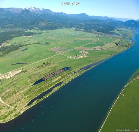
20 Frequently Flooded Areas Total 19,633 acres Concentrated in range and dryland areas along Pend Oreille river Intersects with 6% of total agricultural lands
21 Section 3.2 Focus on Ag Viability

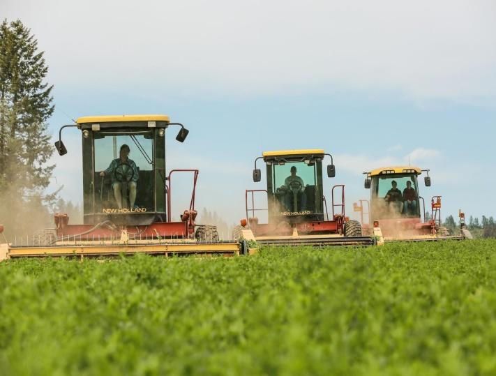
22 Balancing Stewardship Activities with Agricultural Viability Agricultural Viability

23 Agriculture in Pend Oreille County: 2012 Census of Agriculture Summary Pend Oreille County agricultural products (market value): Approximately $3.9 million total annual value 59% was crops 41% was livestock There were approximately 288 farms 34% of farms have less than $1,000 in sales 51% of farms have $1,000 to $10,000 in sales 15% of farms have greater than $10,000 in sales Census of Agriculture 2012
24 SWOT Analysis Preliminary Results Strengths Excellent product (grass fed beef) Strength of family farms Strong demand for product Opportunities Regional market for grass fed beef New technologies and crops Increased irrigation efficiency Agricultural tourism Limited urbanization pressures compare to other areas Multiple smaller operations/integrated farming operations where producers sell to each other, with shared values and commitment to work together Weaknesses Reliance on public lands leases to support ranching Fluctuating price of hay and fertilizers Cost of electricity Short growing season Limited options for crop diversity - wheat and cattle are the primary agricultural products, and subject to commodity prices Limited opportunity to vertically integrate Smaller farms/operations often mean less economic buying power Threats New regulations Predation of livestock Loss of land base to development Wildfires and landslides Land ownership changes and changes from working agricultural lands to recreation lands can change underlying land economics and affordability of lands to continue agriculture Public land management (or lack of it) puts more game pressures on surrounding lands - grazing, trespassing, game population densities - on private lands Equipment costs, input costs, and labor increases from minimum wage makes it challenging to find and retain qualified labor Younger generations not interested in working lands as they seek other career opportunities
25 Review Work Plan Updates and Chapter 4 REVIEW WORK PLAN


26 Critical Areas FWHCA Wetlands Geologic Hazards (Erosion) CARA FFA

27 Direct and Indirect Effects


28 Critical Area Functions Ecosystem Functions Water Quality Hydrology Soil Health Habitat and Values Critical Areas Wetlands Fish and Wildlife Habitat Conservation Areas Critical Aquifer Recharge Areas Geologically Hazardous Areas Frequently Flooded Areas
29 Key Conservation Practices Example Practice Fencing Streambank and Shoreline Protection Forest Understory Management Restoration and Management of Rare and Declining Habitats Ag Type Rangeland Rangeland Dryland Irrigated Rangeland Rangeland Dryland Irrigated Description Managing livestock access to areas with the construction of a barrier fence Protecting and stabilizing streambanks to prevent erosion and enhance fish and wildlife habitat Managing forest composition and understory vegetation to reduce wildfire risk and maintain grazing conditions Reestablishing and/or renovating unique or diminishing native terrestrial and aquatic ecosystems Water Quality Critical Areas Function Hydrology Soil Health Habitat Agricultural Viability Prevent soil loss Weed management Pollinator/beneficial organisms Increased yield and fertility Prevent soil loss Weed management Pollinator/beneficial organisms Prevent soil loss Weed management Pollinator/beneficial organisms Weed management Pollinator/beneficial organisms
30 VSP Checklist Discuss content - show on screen
31 Next Steps Upcoming meeting schedule: May 1st and June 5 th Upcoming Meeting topics: Chapters 5 and 6 Goals & Benchmarks Adaptive Management Discuss implementation & outreach
Adams County Voluntary Stewardship Plan
 Adams County Voluntary Stewardship Plan Presented by Ben Floyd, Anchor QEA 1 Agenda Welcome and Meeting Purpose Recap and follow up from December meeting Conceptual Overview of Work Plan Introduction Regional
Kittitas County Voluntary Stewardship Plan
 Kittitas County Voluntary Stewardship Plan Presented by John Small and Nora Schlenker, Anchor QEA 1 Agenda Welcome and Meeting Purpose VSP Work Plan Overview and Timeline Conceptual Overview of Work Plan
Kittitas County Voluntary Stewardship Plan
 Kittitas County Voluntary Stewardship Plan Presented by John Small and Nora Schlenker, Anchor QEA 1 Agenda Welcome and Follow-up from Last Meeting Follow-up on Comments Received Stewardship Practices Description
3 Baseline and Existing Conditions
 1 2 3 4 5 6 7 8 9 10 11 12 13 14 3 Baseline and Existing Conditions The effective date of the VSP legislation is July 22, 2011. This is also the date chosen by the legislature as the applicable baseline
Kittitas County Voluntary Stewardship Plan
 Kittitas County Voluntary Stewardship Plan Presented by John Small and Nora Schlenker, Anchor QEA 1 Agenda Welcome and Follow-up from Last Meeting Protection and Enhancement Strategies Goals and Measurable
2 Okanogan County Regional Setting
 1 1 1 1 1 1 1 1 0 1 0 1 Okanogan County Regional Setting.1 Okanogan County Profile Okanogan County is in North Central Washington State. The county borders Canada in the North and the southern and eastern
1.1 Frequently Asked Questions What is a Voluntary Stewardship Program?
 1 Introduction The Washington State Growth Management Act (GMA) was adopted by the Washington State Legislature in 1990. The GMA provides for citizens, communities, local governments, and the private sector
Table 1. Relationship between critical areas and key functions. Shaded areas represent functions associated with each critical area. Storage.
 Flow Storage Nutrients Temperature Bacteria Contaminants Cowlitz County Voluntary Stewardship Program 4 Goals, Benchmarks, Strategies and Indicators 4.1 Approach Goals and Benchmarks Critical Areas Functions
Thurston County Voluntary Stewardship Program Work Plan. Appendix C Benchmarks, Monitoring and Adaptive Management
 Thurston County Voluntary Stewardship Program Work Plan Appendix C Benchmarks, Monitoring and Adaptive Management Table of Contents 1 Critical Areas Benchmarks and Monitoring... 2 1.1 Critical Areas Benchmarks
Inventory of Management Programs
 Appendix C Salmon Recovery Plan Inventory of s Table 1 Inventory of management programs, sponsors or agencies, area affected by the programs, goal of the programs, and a determination whether the program
FACT SHEET: BLM, USFS Greater Sage-Grouse Conservation Effort
 EMBARGOED UNTIL SEPTEMBER 22, 2015 @ 12:00PM ET FACT SHEET: BLM, USFS Greater Sage-Grouse Conservation Effort Overview Effective conservation of the greater sage-grouse and its habitat requires a collaborative,
awetlands aprairie aforests ahabitat for Fish, Game & Wildlife
 Rec. H1 priority land habitats pp. 63-67 Priority areas identified in integrated mapping assessing critical land habitat and threats to habitat pp.33-63 o Mapping is scalable for use in localized areas
The Wyoming Wildlife Advocates also value the Caribou-Targhee National
 May 20, 2016 Jay Pence District Ranger USDA Forest Service Caribou-Targhee National Forest P.O. Box 777 Driggs, ID 83422 Re: Comments on the proposed Southern Valley Recreation Project, submitted to the
Statement of. Jim Stone, Rancher and Chairman Rolling Stone Ranch and The Blackfoot Challenge
 Statement of Jim Stone, Rancher and Chairman Rolling Stone Ranch and The Blackfoot Challenge Before the U.S. House of Representatives Subcommittee on National Parks, Forests, and Public Lands at the hearing
Innovative Grazing Management
 Innovative Grazing Management Tools and Incentives for Ranchers Presented by Dan Macon Nevada County Land Trust June 28, 2006 Introduction Overview Why do ranchers care about environmental stewardship?
Project Information. Pursuant to Section 404 of the Clean Water Act (33 U.S. Code 1344), notice is hereby given that
, notice is hereby given that") US ARMY Corps Of Engineers Little Rock District JOINT PUBLIC NOTICE CORPS OF ENGINEERS STATE OF ARKANSAS Application Number: 2013-00331 Date: November 4, 2013 Comments Due: December 4, 2013 TO WHOM IT
US ARMY Corps Of Engineers Little Rock District JOINT PUBLIC NOTICE CORPS OF ENGINEERS STATE OF ARKANSAS Application Number: 2013-00331 Date: November 4, 2013 Comments Due: December 4, 2013 TO WHOM IT
VOLUNTARY STEWARDSHIP PROGRAM
 VOLUNTARY STEWARDSHIP PROGRAM KITTITAS COUNTY WATERSHED GROUP MEETING ARMORY HALL, KITTITAS VALLEY EVENT CENTER MARCH 14, 2017 1:00PM 4:00PM WELCOME Introductions Review Agenda WATERSHED GROUP Ag Interests
Great Basin Landscape Conservation Cooperative 2017 Online Public Forum Summary Report
 Photo: BLM Nevada Great Basin Landscape Conservation Cooperative 017 Online Public Forum Summary Report Online Public Forum Overview The Great Basin Landscape Conservation Cooperative (LCC) hosted an online
Alameda County Resource Conservation District
 Goal A. Protect and Enhance Alameda County Working Lands... 1 Goal B. Provide Conservation and Land Stewardship Education and Outreach... 2 Goal C. Protect and Enhance Habitats and Watershed Health in
Critical Areas Ordinance
 Public Review Draft //7 Public Review Draft //7 4 5 6 Kitsap County Code Title 9 Critical Areas Ordinance 7 8 9 0 Underline / Strike out Version 9.800 Appendices 4 5 6 7 8 9 0 4 5 Public Review Draft //7
The Purpose and Scope of this Guidance
 Introduction The nation s aquatic resources are among its most valuable assets. While environmental protection programs in the United States have successfully improved water quality during the past 25
Burns Paiute Tribe s s Wildlife Acquisitions
 Burns Paiute Tribe s s Wildlife Acquisitions Logan Valley 2000-009 009-00 Purchased: April 2000 Malheur River 2000-027 027-0000 Purchased: November 2000 Location of Properties Malheur Malheur River Subbasin
OUTDOOR PROPERTIES. Independence Valley Farm & Ranch
 OUTDOOR PROPERTIES of Independence Valley Farm & Ranch INTRODUCTION Located in Northeast Nevada, the Independence Valley Farm & Ranch (IVF&R) is a spectacular property with endless natural resources. Currently
1. GENERAL DESCRIPTION OF LAND USE / COVER TYPES (SEE GENERAL DESCRIPTIONS ON PAGE 7) A 2. ADJACENT LANDS & EASEMENTS 3. FAMILY AGRICULTURAL LEGACY
 A 2. ADJACENT LANDS & EASEMENTS 3. FAMILY AGRICULTURAL LEGACY") CONSERVATION EASEMENT PROJECT: COUNTY: NAME OF LANDOWNER: CELL/OFFICE PHONE: NAME OF FARM / SITE MANAGER: CELL/OFFICE PHONE: GENERAL DESCRIPTION OF LAND USE / COVER TYPES (SEE GENERAL DESCRIPTIONS ON PAGE
CONSERVATION EASEMENT PROJECT: COUNTY: NAME OF LANDOWNER: CELL/OFFICE PHONE: NAME OF FARM / SITE MANAGER: CELL/OFFICE PHONE: GENERAL DESCRIPTION OF LAND USE / COVER TYPES (SEE GENERAL DESCRIPTIONS ON PAGE
Anyone can come in for technical assistance. NRCS and its partners use the CTA program to provide technical assistance to: farmers, ranchers, local
 1 The Natural Resources Conservation Service (NRCS) is the U.S. Department of Agriculture's principal agency for providing free conservation technical assistance to private landowners, conservation districts,
Whatcom County Farm Plan
 Whatcom County Farm Plan Planning Workbook: Checklist and Action Plan For use with the publication: Tips on Land and Water Management For: Land Owner Address Date Introduction Conservation planning means
Rangeland Conservation Effects Assessment Program (CEAP)
") Rangeland Conservation Effects Assessment Program (CEAP) Program Overview with Emphasis on the Literature Review of Rangeland Practices Pat L. Shaver, PhD Rangeland Management Specialist USDA-NRCS West
Rangeland Conservation Effects Assessment Program (CEAP) Program Overview with Emphasis on the Literature Review of Rangeland Practices Pat L. Shaver, PhD Rangeland Management Specialist USDA-NRCS West
Grand Traverse Bay Watershed Protection Plan:
 Grand Traverse Bay Watershed Protection Plan: An Overview Sarah U Ren Program Director The Watershed Center 231-935-1514, suren@gtbay.org What is a Watershed? A watershed is an area of land that captures
Community Workshops Summary Prepared February 2016
 Community Workshops Summary Prepared February 2016 Introduction Stevens County is preparing an updated Shoreline Master Program (SMP), and the City of Kettle Falls and the towns of Marcus and Northport
Report. Environmental Water Demands. Butte County Department of Water and Resource Conservation Integrated Water Resources Plan.
 Report Butte County Department of Water and Resource Conservation Integrated Water Resources Plan s June 2004 s Section 1 - Introduction 1.1 Project Description This project is a preliminary investigation
FARM BILL 2002 Colorado Conservation Provisions
 United States Department of Agriculture Natural Resources Conservation Service FARM BILL 2002 Colorado Conservation Provisions Conserving Natural Resources on Colorado s Privately Owned Farmland Farm Bill
Reservoir age, increasing human population,
 B-6249 02/12 Eagle Mountain Watershed Management Brent Clayton, Justin Mechell, David Waidler and Clint Wolfe* Reservoir age, increasing human population, and changing land uses have prompted the development
Long Range Plan
 ooooooo Long Range Plan 2015-2020 ~ 11221 US Hwy 30 ~ Cheyenne, WY 82009 MISSION STATEMENT Provide Laramie County citizens with the necessary information and technical assistance to support sustainable
Agroforestry: Sustainable Agriculture Through the Blending of Trees and Agriculture
 Agroforestry: Sustainable Agriculture Through the Blending of Trees and Agriculture Andy Mason, Interim Director USDA National Agroforestry Center C-FAR Seminar July 19, 2010 Presentation Objectives What
Riparian Forest Buffer Panel (Bay Area Incentive Programs)
") Program Buffer Incentive Program Virginia Agricultural BMP Cost- Share Program Virginia Agricultural BMP Cost- Share Program Practice Woodland Buffer Filter Area Loafing Lot Management System Incentive,
Program Buffer Incentive Program Virginia Agricultural BMP Cost- Share Program Virginia Agricultural BMP Cost- Share Program Practice Woodland Buffer Filter Area Loafing Lot Management System Incentive,
SUMMARY OF THE MARTIN BASIN RANGELAND PROJECT FINAL ENVIRONMENTAL IMPACT STATEMENT BACKGROUND
 SUMMARY OF THE MARTIN BASIN RANGELAND PROJECT FINAL ENVIRONMENTAL IMPACT STATEMENT BACKGROUND Project Area The Humboldt-Toiyabe National Forest is proposing to continue livestock grazing under a specific
Sponsored by PRNNP Management Project & CTIC. Lower Pecos River Watershed Alliance
 Sponsored by PRNNP Management Project & CTIC Lower Pecos River Watershed Alliance LPRWA Mission To protect and improve the watershed health for all users/uses of the Pecos River watershed by identifying
Frequently Asked Questions
 Frequently Asked Questions Chelan County Shoreline Master Program Update July 2009 What is an SMP? Shoreline Master Programs (SMP) are a combination of rules and comprehensive planning that are prepared
Agricultural Resource Management Plan. Wind River Indian Reservation. July 11, 2016
 Agricultural Resource Management Plan Wind River Indian Reservation July 11, 2016 1 Acknowledgements Executive Summary Table of Contents I. Introduction a. Purpose b. Scope The scope of the Agricultural
Water for All, Now and Into the Future: Water Quantity in Wisconsin. A report by the Sierra Club-John Muir Chapter
 Water for All, Now and Into the Future: Water Quantity in Wisconsin A report by the Sierra Club-John Muir Chapter Table of Contents Background The Importance of Water Quantity Water Use in Wisconsin Excessive
Conservation Practices for Water Quality: Sediment & Nutrient Control. Trap Sediments/Trap Nutrients on the Field. Improve Soil Health.
 Conservation Practices for Water Quality: Sediment & Nutrient Control. Trap Sediments/Trap Nutrients on the Field. Improve Soil Health. Sediment Conservation Cover Cover Crop Critical Area Planting Field
9/4/2013 CHAPTER 4 ECOLOGY AND GEOLOGY. Ecosystem. Ecology & Geology Linkage. Fundamental Ecology Terms. Natural Service Functions of Ecosystems
 CHAPTER 4 ECOLOGY AND GEOLOGY Ecology & Geology Linkage Ecology Study of relationships between living things and their environments; the study of control factors over the distribution, abundance, and health
June 15, 2010 Public Meeting. Byron Petrauskas Blue Ridge Environmental Solutions, Inc.
 June 15, 2010 Public Meeting Byron Petrauskas Blue Ridge Environmental Solutions, Inc. Virginia Department of Environmental Quality has identified that poor water quality exists in: Little Dark Run and
Introducing Rangelands-Part 2
 Introducing Rangelands-Part 2 Created by: IRRC Subject: Science, Social Studies, Language Arts Time Required: 30 minutes Date: Grade Level: 4th Standards: Social Studies Standard 2: Geography Language
ON-FARM CONSERVATION: Resource Inventory Checklist
 ON-FARM CONSERVATION: Resource Inventory Checklist The Resource Inventory Checklist focuses on current agricultural land use, farm infrastructure and natural resources. This worksheet will help you assess
WHATCOM COUNTY STANDARD CONSERVATION FARM PLAN PLANNING WORKBOOK: Checklist and Action Plan
 WHATCOM COUNTY STANDARD CONSERVATION FARM PLAN PLANNING WORKBOOK: Checklist and Action Plan For use with the publication: Tips on Land and Water Management For: Land Owner Operator Address Date 0 Introduction
Voluntary Stewardship Program Workgroup
 Voluntary Stewardship Program Workgroup VSP Workgroup Meeting #6 Thursday, September 8th Location: St Mary of the Rosary Catholic Church (Event Room), Chewelah Attendees: 21 (including 4 VSP Staff), Attendance
WHATCOM COUNTY STANDARD FARM CONSERVATION PLAN PLANNING WORKBOOK: Checklist and Action Plan
 WHATCOM COUNTY STANDARD FARM CONSERVATION PLAN PLANNING WORKBOOK: Checklist and Action Plan For use with the publication: Tips on Land and Water Management For: Land Owner Address Date Introduction Conservation
2 Okanogan County Regional Setting
 1 1 1 1 1 1 1 1 0 1 0 1 Okanogan County Regional Setting.1 Okanogan County Profile Okanogan County is in North Central Washington State. The county borders Canada in the North, Ferry County in the east.
4. Present Activities and Roles
 4. Present Activities and Roles The present missions, authorities, activities and roles of the various agencies involved with flood protection, floodplain management and flood-damage reduction are identified
Alameda County Eligibility Requirements for Williamson Act Contracts for Agricultural Uses GUIDELINES FOR COMMERCIAL AGRICULTURE
 Alameda County Eligibility Requirements for Williamson Act Contracts for Agricultural Uses GUIDELINES FOR COMMERCIAL AGRICULTURE Introduction These Guidelines are intended to summarize the requirements
Chapter 7 Livestock Grazing and Rangeland Issues
 Chapter 7 Livestock Grazing and Rangeland Issues Chapter 7 Livestock Grazing and Rangeland Issues Learning Objectives: 1) To discuss contentious issues involving livestock grazing on arid and semiarid
Lake Fork of the Gunnison Watershed: Status and Stewardship. Camille Richard, Project Director
 Lake Fork of the Gunnison Watershed: Status and Stewardship Camille Richard, Project Director Upper Gunnison Basin Lake Fork Watershed 7,500 14,309 ft Sagebrush to alpine 432 square miles Population 900
Greater Spokane River RCPP: Finding Common Ground between Environmental and Agricultural Interests
 Greater Spokane River RCPP: Finding Common Ground between Environmental and Agricultural Interests Walt Edelen, Water Resources Program Manager Ty Meyer, Production Ag Manager Spokane Environmental Challenges
State of the Valley Report
 State of the Valley Report An overview of the characteristics and trends of natural resources in the San Joaquin Valley s rural spaces, with an eye on resource sustainability for the future Aerial view
SOCIO-ECOLOGICAL RESEARCH TOPICS FOR THE BLUE MOUNTAINS
 SOCIO-ECOLOGICAL RESEARCH TOPICS FOR THE BLUE MOUNTAINS Stakeholder Forum to Identify Research Topics and Specific Questions and Issues of High Priority for Natural Resource Management Topics 1. Rural
Conversion of Pine Lands to Row Crop Agriculture; Who Would Have Guessed?
 Conversion of Pine Lands to Row Crop Agriculture; Who Would Have Guessed? Darrin Hoverson, MN DNR Area Hydrologist Ecological & Water Resources State of the Water Conference April 15, 2015 Local Impacts
Grand Traverse Bay Watershed Protection Plan:
 Grand Traverse Bay Watershed Protection Plan: An Overview Sarah U Ren Program Director The Watershed Center 231-935-1514, suren@gtbay.org The Grand Traverse Bay Watershed 973 square miles Bay Volume =
Public Lands Management A Local Perspective on Public Lands Grazing
 Public Lands Management A Local Perspective on Public Lands Grazing Presented by Dan Macon High Sierra Resource Conservation & Development Council November 8, 2005 Introduction/Overview Personal/Professional
Voluntary Stewardship Program Workgroup
 Voluntary Stewardship Program Workgroup VSP Workgroup Meeting #5 Thursday, August 11 th Location: St Mary of The Rosary Catholic Church (Event Room), Chewelah Attendees: 32 (including 6 VSP Staff), Attendance
Maitland Valley WATERSHED
 Maitland Valley WATERSHED Report Card 2018 Maitland Conservation has prepared this report card as a summary of the state of your forests, wetlands, and water resources. WHERE ARE WE? We are one of 36 Conservation
Observed and Projected Temperature Rise
 Midwest Great Plains Regional Climate Impacts: Great Plains Observed and Projected Temperature Rise The Great Plains is characterized by strong seasonal climate variations. Over thousands of years, records
Rangeland Research Update
 Ken Tate and Leslie Roche Rangeland Watershed Lab UC Davis UCCE rangelandwatersheds.ucdavis.edu Rangeland Research Update Presented at CA Woolgrower's Association Meeting 22 August 2014 Rangeland Management
West Fork White River Watershed Conservation Map Summaries. Prepared for the Beaver Watershed Alliance. By the Watershed Conservation Resource Center
 West Fork White River Watershed Conservation Map Summaries Prepared for the Beaver Watershed Alliance By the Watershed Conservation Resource Center November 2014 The Watershed Conservation Resource Center
United States Department of Agriculture. Soil Conservationist NATURAL RESOURCES CONSERVATION SERVICE
 United States Department of Agriculture Soil Conservationist NATURAL RESOURCES CONSERVATION SERVICE Soil Conservationist As an NRCS soil conservationist, you ll spend most of your time in the field working
Watershed Management in Alberta Green Area
 Watershed Management in Alberta Green Area John Diiwu Alberta Outline What is the green area? Key land use activities Need for watershed management Some provincial policies Need for information and tools
SECTION 33 Table of Contents
 SECTION 33 Table of Contents 33 Upper Columbia Subbasin Inventory of Existing Programs Terrestrial.2 33.1 Current Management Directions...2 33.2 Existing and Imminent Protections...3 33.3 Inventory of
ON-FARM CONSERVATION: Resource Inventory Checklist
 ON-FARM CONSERVATION: Resource Inventory Checklist The Resource Inventory Checklist focuses on current agricultural land use, farm infrastructure and natural resources. This worksheet will help you assess
Prioritizing Climate Change Impacts and Action Strategies
 Prioritizing Climate Change Impacts and Action Strategies Chesapeake Bay Program STAC December 8, 2015 2014 Chesapeake Bay Agreement CLIMATE RESILIENCY GOAL: Increase the resiliency of the Chesapeake Bay
HARDIN COUNTY APPRAISAL DISTRICT PRODUCTIVITY GUIDELINES
 HARDIN COUNTY APPRAISAL DISTRICT PRODUCTIVITY GUIDELINES 1. To qualify for an agricultural use or timber use, special valuation, a property must be currently devoted principally (the most important or
May 4, 2010 Public Meeting. Byron Petrauskas Blue Ridge Environmental Solutions, Inc.
 May 4, 2010 Public Meeting Byron Petrauskas Blue Ridge Environmental Solutions, Inc. Virginia Department of Environmental Quality has identified that poor water quality exists in: Browns Run, Craig Run,
NRCS Programs and Practices for Riparian Areas in Hawaii
 NRCS Programs and Practices for Riparian Areas in Hawaii NRCS Pacific Islands Area Hawaii - State (State (PIA) Office Honolulu, Oahu) Seven field offices (Kauai, Oahu, Molokai, Maui, Hawaii) Plant Materials
Pre and Post Vegetation Management Decisions around Burning & Grazing
 Pre and Post Vegetation Management Decisions around Burning & Grazing Stephanie Larson, PhD Livestock & Range Management Advisor Sonoma & Marin Counties Prescriptive Burning Weather Fire Spread, Severity
ON-FARM CONSERVATION: Resource Inventory Checklist
 ON-FARM CONSERVATION: Resource Inventory Checklist The Resource Inventory Checklist focuses on current agricultural land use, farm infrastructure and natural resources. This worksheet will help you assess
Proposed Action and Alternatives
 Chapter Proposed Action and Alternatives Page 15 CHAPTER 2 - PROPOSED ACTION AND ALTERNATIVES INTRODUCTION Chapter 2 describes and compares the Southwest Fence Relocation and Waterline Project s Proposed
Clarks Fork of the Yellowstone Comprehensive River Management Plan
 Clarks Fork of the Yellowstone Comprehensive River Management Plan Background The Clarks Fork of the Yellowstone River is located on the Shoshone National Forest, approximately 30 miles north-northwest
Conservation Planning. Steve Barker, Resource Management Systems LLC
 Conservation Planning Steve Barker, Resource Management Systems LLC Overview What is a conservation plan Conservation Districts The NRCS 9 step planning process First Nations support for Tribal producers
Final Report of the Riparian Forest Buffer Panel
 Chesapeake Bay Program Final Report of the Riparian Forest Buffer Panel Introduction Findings Land Use-Specific Findings On Agricultural Land On Forested Land On Developed and Developing Lands Recommendations
ON-FARM CONSERVATION: RESOURCE INVENTORY CHECKLIST
 ON-FARM CONSERVATION: RESOURCE INVENTORY CHECKLIST American Farmland Trust s Farmland Information Center holds a collection of resources specifically created to help landowners navigate common issues including
Corporate Environmental Water Stewardship Go Green. Todd Reeve October 17, 2017
 Corporate Environmental Water Stewardship Go Green Todd Reeve October 17, 2017 Freshwater & Business Risk #1 threat (World Economic Forum 2016) 2/3 rd of companies report water as substantive risk* 44%
SURVEY OF PUBLIC ATTITUDES ABOUT WATER ISSUES IN COLORADO
 SURVEY OF PUBLIC ATTITUDES ABOUT WATER ISSUES IN COLORADO Matt Neibauer, Reagan Waskom, and Troy Bauder Colorado State University Dept. of Soil and Crop Sciences 1 Northern Plains and Mountains Regional
Climate Change Impacts on Ecosystem Health and Ecosystem Services
 Climate Change Impacts on Ecosystem Health and Ecosystem Services A WA-APA Discussion Paper about Community Resilience November 2015 Brief: Humans rely on intact ecosystems to clean water and air of pollution,
CONSERVATION RESERVE ENHANCEMENT PROGRAM
 Forested Buffers through United States Department of Agriculture s CONSERVATION RESERVE ENHANCEMENT PROGRAM NIKKI DAVIS Restoring streams, creating wildlife habitat, and improving water quality WHAT IS
WATERSHED PARTNERSHIPS. Image:
 WATERSHED PARTNERSHIPS Image: www.hawp.org FORESTS IN HAWAI I Hawai i s forests have evolved over millions of years to contain some of the worlds most unique species. But the history of our forests was
Pennsylvania / NRCS Potomac Pilot Remote Sensing Project Chesapeake Bay Ag Workgroup
 Pennsylvania / NRCS Potomac Pilot Remote Sensing Project Chesapeake Bay Ag Workgroup July 21, 2016 Tom Wolf, Governor Patrick McDonnell, Acting Secretary Introduction and Action Requested NRCS Methodology
Gunnison Basin Wet Meadow and Riparian Restoration and Resilience-Building Project
 Gunnison Basin Wet Meadow and Riparian Restoration and Resilience-Building Project 1. CRITICAL WILDLIFE HABITAT Wet meadows and riparian areas occupy a small proportion of the sagebrush ecosystem in the
3.8 Key Issue: Grazing Economics
 3.8 Key Issue: Grazing Economics Several scoping respondents and EA commenters identified the economic impacts of the proposed actions as an issue. Many of the actions proposed in this document would have
Central Arizona Land Trust Protecting Family Agricultural Lands in the Verde Valley
 Central Arizona Land Trust Protecting Family Agricultural Lands in the Verde Valley Fauna, Farms and Flows Dan Campbell Director, TNC Verde Program Verde River one of the last living rivers left in the
Welcome! Thanks to Our Sponsors
 Purgatoire Watershed Weed Management Collaborative Toxic Plants to Livestock in Southeastern Colorado July 19 th, 2016 Welcome! Thanks to Our Sponsors Morning Refreshments Lunch Plants Poisonous to Livestock
Funding Guidelines State Fiscal Year 2016
 State Fiscal Year 2016 Water Quality Financial Assistance Centennial Clean Water Program Clean Water Act Section 319 Program Stormwater Financial Assistance Program Washington State Water Pollution Control
Common water resource goals
 Healthy Rangeland Watersheds and Productive Livestock Enterprises: Why Not? Society for Range Management Annual Conference Billings, MT February 7, 2011 Common water resource goals Improve water quality.
Chapter 5 Goals and Objectives of the Watershed
 Chapter 5 Goals and Objectives of the Watershed 5.1 Goals for the Watershed 5.2 Objectives for the Watershed Goals 5.2.1 Water Quality Impairments 5.2.2 Preserving and Protecting Designated Areas 5.2.3
Decision Memo. USDA Forest Service Mountain Home Ranger District, Boise National Forest Boise County, Idaho
 Decision Memo BOGUS CREEK OUTFITTERS SPECIAL USE PERMIT RENEWAL USDA Forest Service Mountain Home Ranger District, Boise National Forest Boise County, Idaho August 2014 DECISION It is my decision to renew
Chapter Consultation and Coordination
 Chapter Consultation and Coordination Preparers and Contributors Federal, State, County, and Local Agencies Tribes Organizations Final Environmental Impact Statement for Livestock Grazing on the Battle
Miller Pasture Livestock Water Pipeline Extension Proposed Action
 Introduction Miller Pasture Livestock Water Pipeline Extension Proposed Action USDA Forest Service Williams Ranger District, Kaibab National Forest Coconino County, Arizona February 10, 2017 The Miller
Wildlife and Agricultural Ecosystems
 Wildlife and Agricultural Ecosystems The changing agricultural landscape Green Revolution resulted in substantial changes in agriculture Yields have increased 2% per acre each year since 1948 Corn: 38.5
Watershed Management in the Crooked River Basin:
 Watershed Management in the Crooked River Basin: The Western Juniper Story Max Nielsen-Pincus, Ph.D. Crooked River Watershed Council Watershed Restoration through Juniper Management Produced by The Juniper
JUNE 20, Collaborative Initiatives: Restoring watersheds and large landscapes across boundaries through State and Federal partnerships
 TESTIMONY of LESLIE WELDON DEPUTY CHIEF, NATIONAL FOREST SYSTEM UNITED STATES DEPARTMENT OF AGRICULTURE FOREST SERVICE BEFORE THE SENATE COMMITTEE ON ENERGY AND NATURAL RESOURCES SUBCOMMITTEE ON PUBLIC
USDA and other Government Agency efforts to Enhance Soil and Water Conservation
 USDA and other Government Agency efforts to Enhance Soil and Water Conservation USDA-NRCS The Natural Resource Conservation Service (NRCS) was originally the Soil Conservation Service (SCS) SCS Created
Project Goals and Scoping
 Prepared for: Boulder County, Colorado Flood Planning & Preliminary Design Services for South St. Vrain Creek Restoration at Hall Ranch and Scoping May 24, 2016 Meeting with General Public In association