MINNESOTA ARCHITECTURE - HISTORY INVENTORY FORM
|
|
|
- Elfreda Wilkins
- 6 years ago
- Views:
Transcription
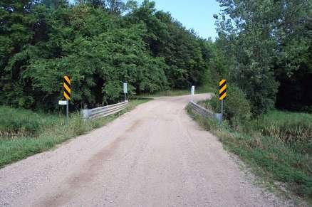
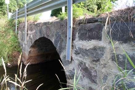
1 Identification Historic Name Bridge Current Name Bridge Field # Address N/A 273rd Street over Washington Creek City/Twp Dassel County Meeker Legal Desc. Twp 119 Range 29 Sec 3 QQ NWSW USGS Quad KINGSTON UTM Zone 15N Datum NAD83 Easting Northing Property ID (PIN) SHPO Inventory Number Review and Compliance Number Form (New or Updated) Updated Linear Feature? No HPC Status: Unknown Resource Type Structure Architect/Engineer Unknown Style No Style Construction Date 1908 Original Use Transportation Current Use Transportation Description Description Bridge is a stone arch bridge built in It is located approximately four miles north of the City of Dassel, in Dassel Township, Meeker County, Minnesota. The bridge is in a rural setting and carries a gravel township road known as 273rd Street along a northwest-southeast alignment over Washington Creek. Bridge is a single-span stone arch bridge with a structure length of 14 feet, a span length of 11 feet, and an out-and-out width of 18 feet. The bridge is built into the shallow embankments on either side of Washington Creek. The structure is constructed of what appears to be locally quarried, rough cut, fieldstone (mostly granite) blocks with irregular coursing. The semicircular arch has a span length of 11 feet. The voussiors are split fieldstones that measure approximately 16 inches in width and 24 inches in height. Flush masonry joints throughout the entire structure are between one and two inches thick (Hess 1987). The bridge does not have parapet walls or a capstone course. Modern, W-beam style galvanized steel railings with end buffers have been added to the sides of the structure and are supported by four steel, C-channel posts on each side, which have been bolted into the faces of the spandrel walls. The deck is surfaced with gravel. Integrity - Bridge remains in its original location and retains its setting; the rural township road which this bridge was built to serve still retains its rural road characteristics as well. Therefore, the bridge retains good integrity of location, setting, feeling and association. Few records exist to document any potential changes to this bridge over time. However, it is known that the pipe railings that were present in 1987 were replaced with modern guard rails in Additionally, according to a MnDOT inspection report, the mortar joints have been tuckpointed at least once over time. The new mortar is lighter in color than the original mortar, and mortar covers the edges of some of the fieldstones on the spandrels; there appears to have been little regard to mimicking the historic joints. However, the joints in the arch retain their historic proportions and profiles. The new guard rail and tuckpointing work are typical of the ongoing maintenance and upkeep required to enable these types of bridges to maintain their historic use. While these alterations may stand out from the original appearance of the bridge, they do not dramatically obscure the original design of the bridge from which the bridge primarily achieves its significance. According to the Minnesota Masonry-Arch Highway Bridges MPDF, the integrity of masonry-arch highway bridges can be seriously compromised when alterations produce a noticeable change in the original design of the masonry arch, which is the defining characteristic of this engineering type. The most common loss of integrity results from concrete additions, whether in the form of a concrete arch, or a concrete slab which overhangs the arch so that the stone arch is no longer visible (Hess 1989:F-3). Such dramatic changes are not present on Bridge 90990, and the bridge has generally good integrity of design, materials, and workmanship. Overall, the bridge meets the integrity requirements of the Minnesota Masonry-Arch Highway Bridges MPDF and retains sufficient integrity to convey its historic significance.
2 EVALUATION AND ANALYSIS Historical Context Minnesota Masonry-Arch Highway Bridges, Historical Narrative Dassel Township in Meeker County was originally organized as Swan Lake Township in the fall of In 1871, the township name was changed to Dassel, after the name of the village within the township s boundaries. Dassel Township and the City of Dassel are named for Bernard Dassel, who was secretary of the St. Paul & Pacific Railroad Company (StP&P). The town of Dassel was laid out and platted by the StP&P in 1869, as the railroad was extended through this location from St. Anthony, Minnesota towards Breckenridge, Minnesota (Alden Ogle & Company 1888: ). A plat map of Dassel Township from 1907 indicates that a road was extant along the present-day alignment of 273rd Street (Barton 1907:10). Though the road is indicated as crossing Washington Creek, Bridge was not erected until It is unknown if a prior structure was located at this crossing; research conducted at Dassel Township, the City of Dassel, the Dassel Historical Society, the Meeker County Historical Society, and Meeker County did not yield information on any previous structures. The split fieldstone of the spandrel walls of Bridge matches the glacial erratic scatters in the adjacent fields (Hess 1988:E5). The use of local fieldstone likely indicates that a local resident constructed the bridge using materials that were readily accessible. However, historic research at Dassel Township, the City of Dassel, the Dassel Historical Society, the Meeker County Historical Society, and Meeker County did not yield information on the construction, history, or the name of engineer and/or builder of Bridge The lack of information available to document Bridge is not untypical of research on these types of bridges. Jeffrey Hess notes in the historic context Minnesota Masonry-Arch Highway Bridges that primary sources are remarkably uncooperative in providing information regarding the construction and funding of masonryarch highway bridges (Hess 1989:E-2). Hess continues, stating that since there is so little documentary data on Minnesota masonry-arch bridge construction, the surviving bridges themselves must serve as the principal source of information (Hess 1989:E-3). In 1987, Hess surveyed Bridge as part of a statewide bridge inventory. At that time, the bridge was noted as having pipe -metal railings; these railings also appear in photographs taken during the survey (Hess 1987). It is unknown if these railings were original to the structure, or a later addition. According to a Minnesota Department of Transportation (MnDOT) bridge inspection form, these railings were replaced in 1999 with the current steel guard rails (MnDOT 2012). The same inspection report notes that there has been extensive mortar joint repair to the entire barrel and structure walls, and that the mortar is in excellent condition (MnDOT 2012). Records of any additional changes, alterations, or repairs to this bridge have not been found. Significance In 1989, the National Register of Historic Places Multiple Property Documentation Form: Minnesota Masonry-Arch Highway Bridges (Minnesota Masonry-Arch Highway Bridges MPDF) was published. The Minnesota Masonry-Arch Highway Bridges MPDF states that a structure can be eligible for the NRHP under Criterion C if in its setting, form, scale, masonry, and ornamentation, it is highly representative of one of the three basic categories of country, city, or park masonry-arch highway bridges (Hess 1989:F-4). Within the Minnesota Masonry-Arch Highway Bridges MPDF, Bridge is highlighted as an example of a country bridge that was constructed of local stone. A country bridge is defined by the Minnesota Masonry-Arch Highway Bridges MPDF as a bridge constructed of rubble masonry with mortar joints of at least one inch; one or two semicircular arches with spans between 10 and 15 feet; simple stone or metal railings (which often have been removed); and an overall structure width of about 18 to 20 feet (Hess 1989:E-3). The Minnesota Masonry-Arch Highway Bridges MPDF also states that these bridges rely on their symmetry and proportions for whatever aesthetic statement they make; ornamentation of any type, including datestones, is extremely rare (Hess 1989:E-3). Indeed, a visual inspection
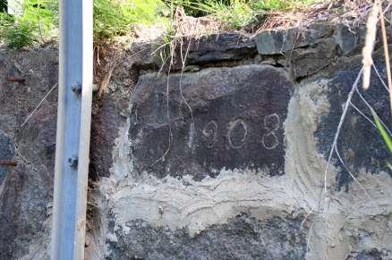
3 and the characteristics of Bridge itself serves as the primary evaluation of the bridge s historic significance. The characteristics of Bridge exemplify the defining features of masonry arch country bridges as identified in the Minnesota Masonry-Arch Highway Bridges MPDF. Bridge is located on a remote farm road, as is typical of such bridges. Additionally, the bridge is constructed of local granite fieldstone and has masonry joints of one to two inches. The bridge has one semicircular arch with a span length of 11 feet, which falls in the 10 to 15 foot range typical of country bridges. The bridge s width is noted as 18 feet, again typical of country bridges. In terms of ornamentation, Bridge is significant as an example of country bridge with a datestone, as the date 1908 has been carved into a stone on the south spandrel wall on the southwest elevation. The Minnesota Masonry-Arch Highway Bridges MPDF notes that such indication of a construction date is extremely rare on country bridges, which often have little to no documentation to identify a construction date. Bridge meets the physical characteristic requirements of a country bridge in its setting, form, scale, masonry, and ornamentation, as defined in the registration requirements contained in the Minnesota Masonry-Arch Highway Bridges MPDF. Additionally, Bridge stands out among country bridges as it is an extremely rare example with a datestone. As such, Bridge is eligible for the NRHP under Criterion C, as a country masonry-arch highway bridge. The period of significance for the bridge is 1908, the year in which it was constructed. Recommendation Bridge exemplifies a country masonry-arch highway bridge as identified by the Minnesota Masonry-Arch Highway Bridges MPDF. The bridge includes character-defining features, such as its locally quarried fieldstone construction, its one semicircular arch with a span length of 11 feet, and its overall structure length and width. It is also significant as an extremely rare example of a masonry-arch country bridge with a datestone. Constructed in 1908, the bridge has had few alterations over time. None of the alterations obscure the original design of the bridge, which is the primary evaluation of the bridge s historic significance. As such, the bridge retains sufficient historic integrity to convey its significance as a country masonry-arch highway bridge. Therefore, Bridge is recommended as eligible for listing in the NRHP under Criterion C, as an example of a country masonry-arch highway bridge within the Minnesota Masonry-Arch Highway Bridges MPDF. The recommended period of significance is 1908, corresponding with the year the bridge was constructed. Sources Alden Ogle & Company 1888 Album of History and Biography of Meeker County, Minnesota. Alden Ogle & Company, Chicago, Illinois. Barton, I. D Plat Book of Meeker County Minnesota. I. D. Barton, St. Cloud, Minnesota. Hess, Jeffrey 1987 MNDOT No Statewide Bridge Survey Inventory Form. Minnesota Department of Transportation, St. Paul, Minnesota. On file at the State Historic Preservation Office, St. Paul, Minnesota National Register of Historic Places Multiple Property Documentation Form: Minnesota Masonry-Arch Highway Bridges Prepared by Jeffrey Hess. On file at the State Historic Preservation Office, St. Paul, Minnesota. Minnesota Department of Transportation [MnDOT] 2012 MnDOT Bridge Inspection Report Bridge Minnesota Department of Transportation, St. Paul, Minnesota. National Register Status Considered Eligible Finding Consultant's Recommendation of Eligibility Eligible - Individual
4 Prepared By Kelli Andre Kellerhals The 106 Group Ltd. Date Surveyed 7/15/2013

5 1 2 Facing NW Facing N

6 3 4 Facing NE Facing E

7 5 6 Facing S Facing NE

8 7 Facing NW

9
MINNESOTA ARCHITECTURE - HISTORY INVENTORY FORM
 Identification Historic Name Split Rock Bridge; Bridge 5744 Current Name Split Rock Bridge; Bridge 5744 Field # Address Country Road 54 over Split Rock Creek City/Twp Eden Township County Pipestone County
Local Historic Bridge Study, Phase II MnDOT Federal Project No.: SPR CR13(001): BR 8813 (114) March 2013 January 2015
: BR 8813 (114) March 2013 January 2015") Local Historic Bridge Study, Phase II MnDOT Federal Project No.: SPR CR13(001): BR 8813 (114) March 2013 January 2015 The following is a copy of the National Register of Historic Places (National Register)
Local Historic Bridge Study, Phase II MnDOT Federal Project No.: SPR CR13(001): BR 8813 (114) March 2013 January 2015 The following is a copy of the National Register of Historic Places (National Register)
MINNESOTA ARCHITECTURE - HISTORY INVENTORY FORM
 Identification Historic Name Bridge 5388 Current Name Bridge R0529 Field # Address State Highway 2 over the Little Iowa River City/Twp LeRoy Township County Mower Legal Desc. Twp 101N Range 14W Sec 21
MINNESOTA ARCHITECTURE - HISTORY INVENTORY FORM
 Identification Historic Name Bridge 89850 Current Name Bridge 89850 Field # Address N/A CSAH 17 over Minnesota River City/Twp Delhi County Redwood Legal Desc. Twp 113 Range 36 Sec 3 QQ NWSW USGS Quad DELHI
MINNESOTA ARCHITECTURE - HISTORY INVENTORY FORM
 Identification Historic Name Iron Wagon Bridge; Bridge 7965 Current Name Coffee Street Bridge Field # Address Ped over South Branch of the Root River City/Twp Lanesboro County Fillmore County Legal Desc.
MINNESOTA HISTORIC PROPERTY RECORD PART I. PROPERTY IDENTIFICATION AND GENERAL INFORMATION
 MINNESOTA HISTORIC PROPERTY RECORD PART I. PROPERTY IDENTIFICATION AND GENERAL INFORMATION Common Name: Camp Ripley Bridge Bridge Number: 4969 Identification Number: Location: Feature Carried: TH 115 Feature
3.1 MASONRY SMALL STRUCTURES. Historical Overview
 3.1 MASONRY SMALL STRUCTURES Historical Overview There are no known masonry arched culverts or bridges in Maryland that date to the seventeenth or eighteenth centuries (Spero 1995: 50). There are however,
MINNESOTA ARCHITECTURE - HISTORY INVENTORY FORM
 Historic Name Identification Phelps Mill Bridge SHPO Inventory Number Review and Compliance Number Current Name Bridge L0885 Field # Address N/A Pedestrian Crossing over Ottertail River City/Twp Maine
United States Department of the Interior National Park Service. 1. Name of Property
 NFS Form 10-900 (Rev. 10-90} OMB No. 1024-0018 This form is for use in nominating or requesting determinations for individual properties and districts. See instructions in How to Complete the National
Historic Bridge Adoption Information Packet. Medina County CR 662 Francisco Perez Creek
 Historic Bridge Adoption Information Packet Medina County CR 662 Francisco Perez Creek April 16, 2018 Table of Contents Announcement... 3 Bridge Location... 4 Bridge Information... 4 Bridge Condition and
MINNESOTA ARCHITECTURE - HISTORY INVENTORY FORM
 Identification Historic Name Northern Pacific Railway Bridge 9 Current Name Bridge 94246 / Minneapolis Bridge 7214 Field # Address NP over Mississippi River City/Twp Minneapolis County Hennepin Legal Desc.
Historic Bridge Adoption Information Packet
 Historic Bridge Adoption Information Packet Harris County Navigation Boulevard Underpass Bridge Commerce Street and Houston Belt & Terminal Railroad over Navigation Boulevard May, 2018 Table of Contents
Mendenhall, J.R. Farm
 89A PENNSYLVANIA HISTORIC RESOURCE SURVEY FORM PHOTO/SITE PLAN SHEET Pennsylvania Historical and Museum Commission, Bureau of Historic Preservation Commonwealth Keystone Building, 2nd Floor, 400 North
The New Jersey Historic Bridge Database
 The New Jersey Historic Bridge Database Based on survey data and recommendations prepared by A.G. Lichtenstein & Associates, Inc. For The New Jersey Department of Transportation Bureau of Environmental
Joseph Gladke with Hennepin County Public Works Charlene Roise with Hess Roise. Fremont Avenue Bridge. Not applicable.
 Property Location: Project Name: HERITAGE PRESERVATION APPLICATION SUMMARY Fremont Avenue bridge over the Midtown Greenway Fremont Avenue Bridge (L8901) Replacement Prepared By: Hilary Dvorak, Principal
New Haven-Hartford-Springfield High-Speed Intercity Passenger Rail Project
 Annual Programmatic Agreement Report New Haven-Hartford-Springfield High-Speed Intercity Passenger Rail Project November 30, 2015 In accordance with the Programmatic Agreement Among the Federal Railroad
Architectural Inventory Form
 COLORADO CULTURAL RESOURCE SURVEY Page 1 of 8 Official Eligibility Determination (OAHP use only) Rev. 9/98 OAHP1403 Date Initials Determined Eligible National Register Determined Not Eligible National
Historic Property Report
 Historic Name: Pernsteiner Farm Property ID: 36348 Location Address: GeographicAreas: 5308 S Glenrose Rd, Spokane, Washington, 99223, USA SPOKANE NE Quadrangle,Spokane,Spokane County,T25R43E35,SPOKANE
REHABILITATION PACKAGE 4-a
 4-a WINONA BRIDGE (BRIDGE 5900) REHABILITATION PACKAGE 4-a Rehab option 4-a is a rehabilitation package whereby all spans of the existing steel truss structure would be rehabilitated and strengthened.
Architectural Inventory Form
 COLORADO CULTURAL RESOURCE SURVEY Page 1 of 7 Official Eligibility Determination (OAHP use only) Rev. 9/98 OAHP1403 Date Initials Determined Eligible National Register Determined Not Eligible National
State Level Historic Documentation Report. Poca Truss Bridge Roane County
 State Level Historic Documentation Report State Project No. S344-13-7.42 Federal Project No. ACST-0013(062)D Poca Truss Bridge Roane County Prepared by: Randy Epperly, Historian Department of Transportation
UNDERWATER BRIDGE INSPECTION REPORT DISTRICT 6 - RICE COUNTY
 UNDERWATER BRIDGE INSPECTION REPORT STRUCTURE NO. 66532 227 th STREET (TWP 45) OVER THE STRAIGHT RIVER DISTRICT 6 - RICE COUNTY SEPTEMBER 12, 2012 PREPARED FOR THE MINNESOTA DEPARTMENT OF TRANSPORTATION
E Main Street June 14, 2010 Landmarks Commission Meeting
 Madison Landmarks Commission First Settlement Historic District Criteria for the review of new construction Address: Date: Form Prepared By: 517-523 E Main Street June 14, 2010 Landmarks Commission Meeting
APPENDIX G Enviromental Documents
 APPENDIX G Enviromental Documents CACHE CREEK APN 060-230-007 LOWREY KATHERINE A ETAL 5.20 ACRES APN 060-230-009 FACCIUTO VINCENT R & VICTORIA 7.78 ACRES APN 060-251-001 LLOYD TRUST ETAL & LLOYD FAM REV
Minnesota Department of Transportation (MnDOT) Local Historic Bridge Report
 Local Historic Bridge Report") Executive Summary Bridge 3130, constructed in 1920, carries Township Road 232 over the Blue Earth River about one-half mile south of Blue Earth in rural southwestern Faribault County. Blue Earth City Township
Executive Summary Bridge 3130, constructed in 1920, carries Township Road 232 over the Blue Earth River about one-half mile south of Blue Earth in rural southwestern Faribault County. Blue Earth City Township
Architectural Inventory Form
 COLORADO CULTURAL RESOURCE SURVEY Page 1 of 8 Official Eligibility Determination (OAHP use only) Rev. 9/98 OAHP1403 Date Initials Determined Eligible National Register Determined Not Eligible National
UNDERWATER BRIDGE INSPECTION REPORT STRUCTURE NO COUNTY STATE AID HIGHWAY 10 OVER THE POMME DE TERRE RIVER DISTRICT 4 STEVENS COUNTY
 UNDERWATER BRIDGE INSPECTION REPORT STRUCTURE NO. 75501 COUNTY STATE AID HIGHWAY 10 OVER THE POMME DE TERRE RIVER DISTRICT 4 STEVENS COUNTY SEPTEMBER 24, 2012 PREPARED FOR THE MINNESOTA DEPARTMENT OF TRANSPORTATION
HISTORIC RESOURCES INVENTORY - BUILDING AND STRUCTURES
 HISTORIC RESOURCES INVENTORY - BUILDING AND STRUCTURES Connecticut Commission on Culture & Tourism, One Constitution Plaza, 2nd Floor, Hartford, CT 06103 * Note: Please attach any additional or expanded
Subject: Lucretia Mott School No. 3 Rehabilitation. Figure 1 Figure 2 Figure 3
 MEMORANDUM To: Ashley Rosenthal Payne, Indianapolis Historic Preservation Commission Adrienne Schmetzer, Indiana Housing and Community Development Authority Architecture Preservation Interior Design Landscape
Summary of Phase I Archaeological Survey for the NICTD Double Track NWI, Gary, IN, to Michigan City, IN
 Summary of Phase I Archaeological Survey for the NICTD Double Track NWI, Gary, IN, to Michigan City, IN INDOT Des. No. DHPA No. 19318 May 25, 2017 Summary of Phase I Archaeological Survey for the NICTD
Historic Property Report
 Historic Name: Westminster Church Property ID: 706416 Location Address: GeographicAreas: 411 S Washington St, Spokane, Washington, USA Spokane,T25R43E19,SPOKANE NW Quadrangle,Spokane County Information
UNNAMED CREEK SIX-SPAN REINFORCED CONCRETE SLAB WITH MASONRY PIERS WPA BRIDGE Spanning Unnamed Creek Altus vicinity Jackson County Oklahoma
 Spanning Unnamed Creek Altus vicinity Jackson County Oklahoma PHOTOGRAPHS WRITTEN HISTORICAL AND DESCRIPTIVE DATA HISTORIC AMERICAN ENGINEERING RECORD Submitted to: Oklahoma State Historic Preservation
RESIDENTIAL FENCE STANDARDS
 RESIDENTIAL FENCE STANDARDS 3.5200 PURPOSE The standards set forth in this Section are established to encourage the suitable use of land while advancing the following goals of the City: to preserve privacy,
Inventory Methodology for Oklahoma Depression-era Bridges and Bridgeclass
 Inventory Methodology for Oklahoma Depression-era Bridges and Bridgeclass Culverts (interim final) Prepared for Oklahoma Department of Transportation Prepared by www.meadhunt.com December 2012 Table of
UNDERWATER BRIDGE INSPECTION REPORT STRUCTURE NO CR 27 OVER THE RED LAKE RIVER DISTRICT 2 PENNINGTON COUNTY
 UNDERWATER BRIDGE INSPECTION REPORT STRUCTURE NO. 57521 CR 27 OVER THE RED LAKE RIVER DISTRICT 2 PENNINGTON COUNTY PREPARED FOR THE MINNESOTA DEPARTMENT OF TRANSPORTATION BY COLLINS ENGINEERS, INC. JOB
UNDERWATER BRIDGE INSPECTION REPORT STRUCTURE NO CSAH NO. 15 OVER THE ARCOLA CHANNEL HENNEPIN COUNTY
 UNDERWATER BRIDGE INSPECTION REPORT STRUCTURE NO. 27510 CSAH NO. 15 OVER THE ARCOLA CHANNEL HENNEPIN COUNTY MAY 21, 2012 PREPARED FOR THE MINNESOTA DEPARTMENT OF TRANSPORTATION BY COLLINS ENGINEERS, INC.
Minnesota Department of Transportation (MnDOT) Local Historic Bridge Report
 Local Historic Bridge Report") Executive Summary Bridge 90608 is located in a residential neighborhood in the city of Excelsior and carries Minnetonka Boulevard over an inlet of Lake Minnetonka known as St. Albans Bay. It is owned by
Executive Summary Bridge 90608 is located in a residential neighborhood in the city of Excelsior and carries Minnetonka Boulevard over an inlet of Lake Minnetonka known as St. Albans Bay. It is owned by
Architectural Inventory Form
 COLORADO CULTURAL RESOURCE SURVEY Page 1 of 8 Official Eligibility Determination (OAHP use only) Rev. 9/98 OAHP1403 Date Initials Determined Eligible National Register Determined Not Eligible National
Types of Historic Bridges in Minnesota
 MnDOT Local Historic Bridge Study WEB NARRATIVES: TOPIC 2 (FIELD GUIDE) Types of Historic Bridges in Minnesota Minnesota has more than 20,000 bridges. Of these, about 1% are considered significant to our
State-Aid Bridge News July 20, 2004
 State Aid Bridge Staff Changes Steve Brown State-Aid Bridge News July 20, 2004 We are pleased to announce the appointment of Steve Brown as the new State Aid Bridge Engineering Specialist. Mr. Brown previously
UNDERWATER BRIDGE INSPECTION REPORT STRUCTURE NO TRUNK HIGHWAY NO. 3 rd Avenue/Central Avenue OVER THE MISSISSIPPI RIVER
 UNDERWATER BRIDGE INSPECTION REPORT STRUCTURE NO. 2440 TRUNK HIGHWAY NO. 3 rd Avenue/Central Avenue OVER THE MISSISSIPPI RIVER DISTRICT M HENNEPIN COUNTY OCTOBER 23, 2008 PREPARED FOR THE MINNESOTA DEPARTMENT
JOHNSON ROAD COVERED BRIDGE DESCRIPTION
 JOHNSON ROAD COVERED BRIDGE DESCRIPTION The Johnson Road Bridge was built in 1869 and is possibly the oldest Smith Truss in existence. This structure was built using Smith's 1869 patent. This bridge carries
Subject: Amphitheater School District Reroofing Projects Amphi High School, Building 900 Roof Evaluation SCI Project Number:
 27 June 2016 Mr. Shane Chism, AIA Breckenridge Group 4625 E. Fort Lowell Road Tucson, Arizona 85712 Subject: Amphitheater School District Reroofing Projects Amphi High School, Building 900 Roof Evaluation
BYER COVERED BRIDGE DESCRIPTION
 BYER COVERED BRIDGE DESCRIPTION The Byer Bridge was originally built in 1872. This structure was built using a variation of Smith's 1869 patent. This bridge carries Washington Township Road 973 over Pigeon
ARGENTINE CONNECTION BRIDGE TRIPLE TRACK CROSSING. Kansas City Terminal Railway Company
 James P. Hyland Page 1 ARGENTINE CONNECTION BRIDGE TRIPLE TRACK CROSSING Kansas City Terminal Railway Company James P. Hyland, P.E. Senior Bridge Engineer TranSystems Corporation James P. Hyland Page 2
EASTERN SE & 750 CHERRY SE - REQUEST FOR NEW BUILDINGS
 Planning Staff Report Meeting Date: November 1, 2017 215-255 EASTERN SE & 750 CHERRY SE - REQUEST FOR NEW BUILDINGS BACKGROUND: The project in question is in regards to two new buildings previously approved
LAKE CHEMUNG DAM LOCATION MAP
 LAKE CHEMUNG DAM LOCATION MAP LAKE CHEMUNG DAM OUTLET LAKE CHEMUNG DAM From: deq-wrd-qreq To: Steve Nagy Subject: RE: flood or low flow discharge request (ContentID - 168812) Date: Friday, June 26, 2015
SECTION 4(f) EVALUATION ALASKA RAILROAD MOODY TUNNEL REMOVAL FEDERAL TRANSIT ADMINISTRATION U.S. Department of Transportation
 EVALUATION ALASKA RAILROAD MOODY TUNNEL REMOVAL FEDERAL TRANSIT ADMINISTRATION U.S. Department of Transportation") SECTION 4(f) EVALUATION ALASKA RAILROAD MOODY TUNNEL REMOVAL FEDERAL TRANSIT ADMINISTRATION U.S. Department of Transportation INTRODUCTION This has been prepared in compliance with the requirements of
SECTION 4(f) EVALUATION ALASKA RAILROAD MOODY TUNNEL REMOVAL FEDERAL TRANSIT ADMINISTRATION U.S. Department of Transportation INTRODUCTION This has been prepared in compliance with the requirements of
BRIDGE INSPECTION REPORT
 NC DEPARTMENT OF TRANSPORTATION ATTENTION DIVISION OF HIGHWAYS BRIDGE MANAGEMENT UNIT BRIDGE INSPECTION REPORT INSPECTION TYPE: Routine Inspection COUNTY IREDELL BRIDGE NUMBER 480596 INSPECTION CYCLE 2
The following are details of the code requirements of the 2015 International Residential Code for single-story decks.
 The following are details of the code requirements of the 2015 International Residential Code for single-story decks. The 2015 International Residential Code Section R507 contains additional information
Total 1 Total. Current Functions (Enter categories from instructions) 14D07: Gas station 14D09: Automotive service or repair
 14D07: Gas station 14D09: Automotive service or repair") Site Inventory Form State Inventory No. 29-03659 New Supplemental State Historical Society of Iowa Part of a district with known boundaries (enter inventory no.) 29-03685 (November 2005) Relationship:
Site Inventory Form State Inventory No. 29-03659 New Supplemental State Historical Society of Iowa Part of a district with known boundaries (enter inventory no.) 29-03685 (November 2005) Relationship:
(If Urban) Subdivision Original Town Block(s) FR7 Lot(s) N 45' Lot 4 & undivided 1/2 interest N 6' S 54.5'
 Subdivision Original Town Block(s) FR7 Lot(s) N 45' Lot 4 & undivided 1/2 interest N 6' S 54.5'") Site Inventory Form State Inventory No. 09-00851 New Supplemental State Historical Society of Iowa Part of a district with known boundaries (enter inventory no.) 09-00962 (November 2005) Relationship:
Site Inventory Form State Inventory No. 09-00851 New Supplemental State Historical Society of Iowa Part of a district with known boundaries (enter inventory no.) 09-00962 (November 2005) Relationship:
Architectural Inventory Form (page 1 of 5)
") OAHP1403 Rev. 9/98 COLORADO CULTURAL RESOURCE SURVEY (page 1 of 5) I. IDENTIFICATION 1. Resource number 5RT-2114 2. Temporary resource number:145002006 3. County: Routt County 4. City: Steamboat Springs
OAHP1403 Rev. 9/98 COLORADO CULTURAL RESOURCE SURVEY (page 1 of 5) I. IDENTIFICATION 1. Resource number 5RT-2114 2. Temporary resource number:145002006 3. County: Routt County 4. City: Steamboat Springs
III. INVENTORY OF EXISTING FACILITIES
 III. INVENTORY OF EXISTING FACILITIES Within the Growth Management Boundary, the existing storm drainage facilities are largely associated with development that has historically occurred in the ten drainage
Architectural Inventory Form
 COLORADO CULTURAL RESOURCE SURVEY Page 1 of 7 Official Eligibility Determination (OAHP use only) Rev. 9/98 OAHP1403 Date Initials Determined Eligible National Register Determined Not Eligible National
2016 STRUCTURE INSPECTION APPRAISAL REPORT. Prepared For: THE CORPORATION OF THE TOWNSHIP OF AMARANTH COUNTY OF DUFFERIN
 2016 STRUCTURE INSPECTION APPRAISAL REPORT Prepared For: THE CORPORATION OF THE TOWNSHIP OF AMARANTH COUNTY OF DUFFERIN by K. SMART ASSOCIATES LIMITED 8 McIntyre Drive Kitchener ON N2R 1H6 August 2016
Total 1 Total. Current Functions (Enter categories from instructions) 14D09: Automotive service or repair 14D09: Automotive service or repair
 14D09: Automotive service or repair 14D09: Automotive service or repair") Site Inventory Form State Inventory No. 29-03660 New Supplemental State Historical Society of Iowa Part of a district with known boundaries (enter inventory no.) 29-03685 (November 2005) Relationship:
Site Inventory Form State Inventory No. 29-03660 New Supplemental State Historical Society of Iowa Part of a district with known boundaries (enter inventory no.) 29-03685 (November 2005) Relationship:
MINNESOTA HISTORIC PROPERTY RECORD PART I. PROPERTY IDENTIFICATION AND GENERAL INFORMATION
 MINNESOTA HISTORIC PROPERTY RECORD PART I. PROPERTY IDENTIFICATION AND GENERAL INFORMATION Common Name: Stone Arch Bridge Bridge Number: 27004 Identification Number: Location: Feature Carried: Pedestrian
UNDERWATER BRIDGE INSPECTION REPORT STRUCTURE NO CSAH NO. 5 (FRANKLIN AVENUE) OVER THE MISSISSIPPI RIVER HENNEPIN COUNTY
 OVER THE MISSISSIPPI RIVER HENNEPIN COUNTY") UNDERWATER BRIDGE INSPECTION REPORT STRUCTURE NO. 2441 CSAH NO. 5 (FRANKLIN AVENUE) OVER THE MISSISSIPPI RIVER HENNEPIN COUNTY OCTOBER 29, 2012 PREPARED FOR THE MINNESOTA DEPARTMENT OF TRANSPORTATION BY
UNDERWATER BRIDGE INSPECTION REPORT STRUCTURE NO. 2441 CSAH NO. 5 (FRANKLIN AVENUE) OVER THE MISSISSIPPI RIVER HENNEPIN COUNTY OCTOBER 29, 2012 PREPARED FOR THE MINNESOTA DEPARTMENT OF TRANSPORTATION BY
HISTORIC SITES SURVEY STRUCTURE FORM
 SITE INFORMATION *SURVEY DATE: July 20, 2012 *ADDRESS: 30641 466 th Ave. *SURVEYOR: Jim Stone *COUNTY: Clay *CITY: Vermillion LOCATION DESCRIPTION: South Dakota Highway 50 East of Vermillion 2 miles to
February 17, Metal Truss Bridges Under Immediate Threat:
 February 17, 2017 Metal Truss s Under Immediate Threat: These are bridges that are under immediate threat due to replacements shown in the 2017 SYIP or are closed indefinitely with no plan for rehabilitation.
UNDERWATER BRIDGE INSPECTION REPORT STRUCTURE NO CSAH NO. 3 OVER THE RED LAKE RIVER DISTRICT 2 - PENNINGTON COUNTY
 UNDERWATER BRIDGE INSPECTION REPORT STRUCTURE NO. 57518 CSAH NO. 3 OVER THE RED LAKE RIVER DISTRICT 2 - PENNINGTON COUNTY AUGUST 27, 2012 PREPARED FOR THE MINNESOTA DEPARTMENT OF TRANSPORTATION BY AYRES
Winona Bridge Work Package #6. Options Overview
 Winona Bridge Work Package #6 Bridge No. 5900 (Existing Bridge) Approach Span Reconstructions Options Overview May 29, 2016 Background The scope of work on the Winona Bridge project consists of new Bridge
Architectural Inventory Form
 COLORADO CULTURAL RESOURCE SURVEY Page 1 Official eligibility determination (OAHP use only) Date Initials Determined Eligible- NR Determined Not Eligible- NR Determined Eligible- SR Determined Not Eligible-
UNDERWATER BRIDGE INSPECTION REPORT STRUCTURE NO. 55J11 TWP 197 (70 TH AVE NW) OVER A STREAM DISTRICT 6 OLMSTED COUNTY
 OVER A STREAM DISTRICT 6 OLMSTED COUNTY") UNDERWATER BRIDGE INSPECTION REPORT STRUCTURE NO. 55J11 TWP 197 (70 TH AVE NW) OVER A STREAM DISTRICT 6 OLMSTED COUNTY OCTOBER 2, 2012 PREPARED FOR THE MINNESOTA DEPARTMENT OF TRANSPORTATION BY COLLINS
UNDERWATER BRIDGE INSPECTION REPORT STRUCTURE NO. 55J11 TWP 197 (70 TH AVE NW) OVER A STREAM DISTRICT 6 OLMSTED COUNTY OCTOBER 2, 2012 PREPARED FOR THE MINNESOTA DEPARTMENT OF TRANSPORTATION BY COLLINS
HISTORIC RESOURCES INVENTORY - BUILDING AND STRUCTURES
 HISTORIC RESOURCES INVENTORY - BUILDING AND STRUCTURES Connecticut Commission on Culture & Tourism, One Constitution Plaza, 2nd Floor, Hartford, CT 06103 * Note: Please attach any additional or expanded
HISTORIC PROPERTY SURVEY REPORT
 1. UNDERTAKING DESCRIPTION AND LOCATION District County Route Post Miles Unit E-FIS Project Number Phase District Federal Project. Number. County (Prefix, Agency Code, Project No.) Location 04 SC BRLO-5937(124)
- Site Location and Conditions. A. Project Location. B. Existing Conditions
 H&H Report - Site Location and Conditions Page 1 of 2 A. Project Location 1. Site Identification District County Mu nicipali ty 06 Bucks Hilltown (Twp) Site MINSI TRAIL S.R. 4019 Section 60M Segment 0050
TH 95 Met E 92.7 City/Township. Marine on St. Croix, City of Washington Acres 1.3. St. Paul SW Z15 E N
 Historic Name CS # 8210 Other Name SHPO Inv # Location E side of TH 95 just S of the jct of TH 95 and CSAH 7 Hwy District Reference TH 95 Met E 92.7 City/Township County Marine on St. Croix, City of Washington
Architectural Inventory Form
 OAHP1403 Rev. 9/98 COLORADO CULTURAL RESOURCE SURVEY Architectural Inventory Form Official eligibility determination (OAHP use only) Date Initials Determined Eligible- NR Determined Not Eligible- NR Determined
NYSDOT Culvert Inspection Field Guide
 NYSDOT Culvert Inspection Field Guide This guide is a supplement to the Culvert Inventory and Inspection Manual. It is designed to promote uniformity of culvert item ratings by providing culvert inspectors
Derby North Gateway Tax Increment Financing District Redevelopment Project Plan. July 25, 2013
 Derby North Gateway Tax Increment Financing District Redevelopment Project Plan July 25, 2013 1 Table of Contents I. Summary of Feasibility Study... 3 (Includes District Map and Legal Description) II.
Municipal Structure Inspection Form Structure Number: 5
 Inventory Data: Structure Name Keating Rd. Bridge Main Hwy/Road # On Under Crossing Type Non-navig water Road Name Keating Rd Structure Location 0.25 km west of Regional Rd 46 Latitude N 44 29.27 Longitude
Typical Deck Details. Shenandoah County, Virginia. Based on the 2012 Virginia Residential Code
 Shenandoah County, Virginia Typical Deck Details Based on the 2012 Virginia Residential Code The design details in this document apply to residential decks only. Framing requirements are limited to single
Architectural Inventory Form
 COLORADO CULTURAL RESOURCE SURVEY Page 1 of 8 Official Eligibility Determination (OAHP use only) Rev. 9/98 OAHP1403 Date Initials Determined Eligible National Register Determined Not Eligible National
Minnesota Department of Transportation (MnDOT) Local Historic Bridge Report
 Local Historic Bridge Report") Executive Summary Bridge 93844, or the Columbia Park Bridge, was constructed in 1896 to carry traffic over two tracks of the Soo Line Railway (currently the Canadian Pacific Railway) in Minneapolis. In
Executive Summary Bridge 93844, or the Columbia Park Bridge, was constructed in 1896 to carry traffic over two tracks of the Soo Line Railway (currently the Canadian Pacific Railway) in Minneapolis. In
LYNNVILLE ROAD BRIDGE. Site Number D00027 LYNNVILLE ROAD, CONCESSION 11, WINDHAM. 2.3km W of Highway 24
 LYNNVILLE ROAD BRIDGE Site Number LYNNVILLE ROAD, CONCESSION 11, WINDHAM 2.3km W of Highway 24 Ontario Structure Inspection Manual - Inspection Form Site Number: Inventory Structure Name Lynnville Road
HISTORIC RESOURCES INVENTORY - BUILDING AND STRUCTURES
 HISTORIC RESOURCES INVENTORY - BUILDING AND STRUCTURES Connecticut Commission on Culture & Tourism, One Constitution Plaza, 2nd Floor, Hartford, CT 06103 * Note: Please attach any additional or expanded
COLORADO'S TIMBER RIDGE HOMEOWNERS ASSOCIATION POLICY AND ARCHITECTURAL GUIDELINES FOR IMPROVEMENTS (As Revised (1/18/2018)
") COLORADO'S TIMBER RIDGE HOMEOWNERS ASSOCIATION POLICY AND ARCHITECTURAL GUIDELINES FOR IMPROVEMENTS (As Revised (1/18/2018) Pursuant to Article VI, Paragraph G, of Colorado's Timber Ridge Subdivision s
COLORADO'S TIMBER RIDGE HOMEOWNERS ASSOCIATION POLICY AND ARCHITECTURAL GUIDELINES FOR IMPROVEMENTS (As Revised (1/18/2018) Pursuant to Article VI, Paragraph G, of Colorado's Timber Ridge Subdivision s
MISENER DAM. Site Number LYNN STREET, PORT DOVER km N of Highway 6
 NORFOLK COUNTY MISENER DAM Site Number 980501 LYNN STREET, PORT DOVER 0.65 km N of Highway 6 Ontario Structure Inspection Manual - Inspection Form Site Number: 980501 Inventory Structure Name Misener Dam
Bridge Asset Management City of Battle Creek Planning and Projects
 Bridge Asset Management City of Battle Creek Planning and Projects Michigan Bridge Conference, March 20, 2013 Gregory B. Rickmar P.E., Public Works Department, City of Battle Creek Alan Halbeisen, P.E.
Denver, CO Primary external wall material Synthetics / Vinyl
 OAHP1403 Rev. 9/98 COLORADO CULTURAL RESOURCE SURVEY Official Eligibility Determination (OAHP use only) Date Initials Determined Eligible - National Register Architectural Inventory Form Determined Not
SUBJECT: PL Waitsburg Levee Emergency Rehabilitation Project: Walla Walla County, WA
 REPLY TO ATTENTION OF: DEPARTMENT OF THE ARMY WALLA WALLA DISTRICT, CORPS OF ENGINEERS 201 NORTH THIRD AVENUE WALLA WALLA WA 99362-1876 Cultural Resources Branch May 15, 2018 Robert Whitlam, Ph.D. State
Minnesota Department of Transportation (Mn/DOT) Historic Bridge Management Plan
 Historic Bridge Management Plan") Minnesota Department of Transportation (Mn/DOT) Historic Bridge Management Plan Executive Summary Bridge Number: 4969 Bridge 4969, the Camp Ripley Bridge, was built in 1930 to carry vehicular traffic on
Minnesota Department of Transportation (Mn/DOT) Historic Bridge Management Plan Executive Summary Bridge Number: 4969 Bridge 4969, the Camp Ripley Bridge, was built in 1930 to carry vehicular traffic on
Minnesota Department of Transportation (MnDOT) Local Historic Bridge Report
 Local Historic Bridge Report") Executive Summary Bridge 7614 was constructed in 1938 in the Grand Portage National Monument as part of a Civilian Conservation Corps Indian Division (CCC-ID) effort to relocate a highway. The bridge carries
Executive Summary Bridge 7614 was constructed in 1938 in the Grand Portage National Monument as part of a Civilian Conservation Corps Indian Division (CCC-ID) effort to relocate a highway. The bridge carries
ITHACA LANDMARKS PRESERVATION COMMISSION (ILPC)
") CITY OF ITHACA 108 E. Green St. Third Floor Ithaca, NY 14850-5690 DEPARTMENT OF PLANNING, BUILDING, ZONING, & ECONOMIC DEVELOPMENT Division of Planning & Economic Development Telephone: Planning & Development
CITY OF ITHACA 108 E. Green St. Third Floor Ithaca, NY 14850-5690 DEPARTMENT OF PLANNING, BUILDING, ZONING, & ECONOMIC DEVELOPMENT Division of Planning & Economic Development Telephone: Planning & Development
ASBESTOS AND REGULATED WASTE SURVEY REPORT
 ASBESTOS AND REGULATED WASTE SURVEY REPORT CONSULTANTS ENVIRONMENTAL GEOTECHNICAL MATERIALS FORENSICS Bridge No.: 90480 CSAH 19 over Lake Minnetonka Channel Orono, Minnesota AET Project No. 03-04195 Prepared
APPLICATION FOR PIPE OR WIRE OCCUPANCY
 APPLICATION FOR PIPE OR WIRE OCCUPANCY Please answer all questions and direct cover letter / project description, completed application, application fee, and three (3) copies of project plans to: AECOM
Typical Deck Details. Albemarle County, Virginia. Based on the 2012 Virginia Residential Code
 Albemarle County, Virginia Typical Deck Details Based on the 2012 Virginia Residential Code The design details in this document apply to residential decks only. Framing requirements are limited to single
The Homeowner s Building Application Checklist for Constructing a Residential Sundeck
 This checklist provides homeowners a summary of the Building Permit submission requirements for constructing a residential sundeck. Regardless of the deck s walking surface area, if the deck is adjacent
Minnesota Department of Transportation (MnDOT) Local Historic Bridge Report
 Local Historic Bridge Report") Executive Summary Bridge 27547 carries two-way traffic on Chicago Avenue South over Minnehaha Creek. It is owned by the City of Minneapolis. The bridge was designed by R. Fredrickson for the City of Minneapolis
Executive Summary Bridge 27547 carries two-way traffic on Chicago Avenue South over Minnehaha Creek. It is owned by the City of Minneapolis. The bridge was designed by R. Fredrickson for the City of Minneapolis
National Register of Historic Places Registration Form
 NPS Form 10-900 ^X OMB No. 10024-0018 (Oct. 1990) Registration Form This form is for use in nominating or requesting determinations for individual properties and districts. See instructions in How to Complete
Guidelines for planning the construction of a porch.
 PORCHES Guidelines for planning the construction of a porch. 22817 Typo Creek Dr. Stacy, MN 55079 Telephone 651-462-0501 Permits Building permits are required for construction of all new porches. Porches
Minnesota Department of Transportation (MnDOT) Local Historic Bridge Report- Abridged
 Local Historic Bridge Report- Abridged") Local Historic Bridge Report- Abridged Executive Summary Bridge L8560, also known as the Phalen Park Arch Bridge, is a deck arch bridge located in Phalen Park in St. Paul, Ramsey County, Minnesota. The
Local Historic Bridge Report- Abridged Executive Summary Bridge L8560, also known as the Phalen Park Arch Bridge, is a deck arch bridge located in Phalen Park in St. Paul, Ramsey County, Minnesota. The
Mn/DOT BRIDGE INSPECTION REPORT
 08/13/2007 Page 1 of 5 County: City: Township: WINONA DRESBACH Section: 33 Township: 105N Range: 04W Span Type: NBI Deck: 5 Super: 6 Sub: 6 Chan: 8 Culv: N Location: Route: Control Section: AT MINN/WISC
MAINTAINING CHARACTER, IMPROVING SAFETY OREGON S STEALTH RAIL PROGRAM
 0 MAINTAINING CHARACTER, IMPROVING SAFETY OREGON S STEALTH RAIL PROGRAM Rebecca Burrow, PE Oregon Department of Transportation 00 Fairview Industrial Dr SE. MS # Salem, OR 0 Phone (0) -00; Fax (0) -0;
Appendix A. Sample Inspection Report
 Appendix A Sample Inspection Report This page intentionally left blank. PORT AUTHORITY OF ALLEGHENY COUNTY PITTSBURGH, PENNSYLVANIA REPORT ON THE INITIAL NBIS INSPECTION OF CHARTIERS CREEK BRIDGE BMS No.
Minnesota EAW Supplement
 Appendix I: Minnesota EAW Supplement Lower Pool 2 Channel Management Study: Boulanger Bend to Lock and Dam No. 2 Minnesota EAW Item Identification A supplement prepared for the Minnesota DNR to identify
LANDSCAPE RETAINING WALLS
 SUDAS Standard Specifications Division 9 - Site Work and Landscaping Section 9070 - Landscape Retaining Walls LANDSCAPE RETAINING WALLS PART - GENERAL.0 SECTION INCLUDES A. Modular Block Retaining Walls
RESIDENTIAL WALLS AND FENCES
 FENCE / WALL PLOT PLAN * REQUIRED INFORMATION OWNER 1. A Plot Plan should be submitted as part of your Fence / Wall Permit Application to the Community Development Department. 2. Use this example as a