Product Delivery Report for K&C Phase 2. Christian Thiel Friedrich-Schiller-University Jena
|
|
|
- Laurence Wright
- 6 years ago
- Views:
Transcription

1 Product Delivery Report for K&C Phase 2 Christian Thiel Friedrich-Schiller-University Jena Science Team meeting #15 JAXA TKSC/RESTEC HQ, Tsukuba/Tokyo, January 24-28, 2011
2 1. Published (please provide PDF file) K&C deliverables Papers and Reports K&C Phase-1 and Phase 2 reports, contribution to K&C Booklet CH. THIEL, CA. THIEL & C. SCHMULLIUS (2009): Operational Large Area Forest Monitoring in Siberia Using ALOS PALSAR Summer Intensities and Winter Coherence.-In: IEEE Trans. Geoscience and Remote Sensing 47(12), pp CH. THIEL & C. SCHMULLIUS (2009): Examination of Multi-Seasonal ALOS PALSAR Interferometric Coherence for Forestry Applications in the Boreal Zone.-In: Proceedings of 3rd Joint PI Symposium of ALOS Data Nodes for ALOS Science Program, November 2009, Kona, USA. THIEL, CH., M. SANTORO, O. CARTUS, CA. THIEL, T. RIEDEL & C. SCHMULLIUS (2009): Perspectives of SAR based Forest Cover, Forest Cover Change and Biomass Mapping. In: Christophe P. Vasser [Ed.], The Kyoto Protocol: Economic Assessments, Implementation Mechanisms, and Policy Implications, pp , ISBN: THIEL, CA., CH. THIEL, J. REICHE, R. LEITERER & C. SCHMULLIUS (2009): Großflächige Waldüberwachung in Sibirien unter Verwendung von ALOS PALSAR Winter Kohärenzen und Sommer Intensitäten.-In: Proceedings of 29. DGPF Jahrestagung: , Jena, Germany. THIEL, C. & C. SCHMULLIUS (2010): Examination of Summer- and Winter ALOS PALSAR Interferometric Coherence and Phase in Siberia. Proceedings of the ESA Living Planet Symposium, 28 June - 2 July 2010, Bergen, Norway. THIEL, C. & C. SCHMULLIUS (2010): Seasonality of ALOS PALSAR Interferometric Coherence and Interferometric Phase in central Siberia and its implication on forest parameter retrieval. - Proceedings of the International Geoscience and Remote Sensing Symposium IGARSS 10: July 2010, Hawaii, USA.
3 K&C deliverables Papers and Reports 1. Published (please provide PDF file) 2. Submitted/in preparation THIEL, C. (spring 2011) et. al: Seasonality of ALOS PALSAR Interferometric Coherence and Interferometric Phase in central Siberia and its implication on forest parameter retrieval.-in: IEEE Trans. Geoscience and Remote Sensing. Sen4Science, ALOS Symposium 2011 etc.
4 K&C deliverables Original idea of the phase 2 proposal was to use the information contained in the winter coherence additionally to the backscatter for land cover mapping in the boreal zone. This idea was based on the very promising results of phase one. So far, the data base in terms of coherence data strips could not be provided. However, the whole approach is pending and might be accomplished at phase 3, at least for a smaller demonstration area. New overall topic: investigate use of interferometric coherence for forest biomass estimation
5 ALOS-PALSAR coherence for biomass estimation in the boreal zone Background
6 ALOS-PALSAR coherence for biomass estimation in the boreal zone Background Assumption: Decreasing coherence caused by volume decorrelation and temporal decorrelation
7 Data
8 Winter vs. Summer coherence Winter coherence (46 days) Summer coherence (46 days) This behavior was found for all sites. Dependency of perpendicular baseline?
9 Forest coherence versus perpendicular baselines: summer Horizontal lines denote coherence (and its standard deviation) for decorrelated data
10 Forest coherence versus perpendicular baselines: summer Horizontal lines denote coherence (and its standard deviation) for decorrelated data
11 Forest coherence versus perpendicular baselines: summer Temporal baseline = 92 days (blue) and > 92 days (red), all perpendicular baselines
12 Forest coherence versus perpendicular baselines: winter
13 Forest coherence versus perpendicular baselines: winter Temporal baseline = 92 days (blue) and > 92 days (red), all perpendicular baselines Is volume decorrelation occurring?
14 Summary of coherence behavior (averaged over 10 sites)
15 Summary of coherence behavior (averaged over 10 sites) Average coherence for stem volume m³/ha Number of samples 1 sample = 1 coherence image w = winter s = summer 1,2,3 = Δ cycle = mean over scenes - = min/max B>2km B>2km B>2km
16 Summary of coherence behavior (averaged over 10 sites) Saturation level [m³/ha] Number of samples 1 sample = 1 coherence image w = winter s = summer 1,2,3 = Δ cycle = mean over scenes - = min/max B>2km B>2km B>2km
17 Summary of coherence behavior (averaged over 10 sites) R² stem volume vs. coherence 10 m³/ha biomass class level) Number of samples 1 sample = 1 coherence image w = winter s = summer 1,2,3 = Δ cycle = mean over scenes - = min/max B>2km B>2km B>2km
")
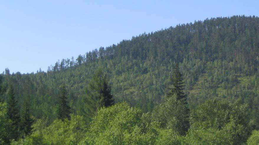
18 Investigation of interferometric phase Clear-cuts visible at shaded relief based on SRTM elevation data (Chunsky N)
 Summer INSAR Phase RGB =")
19 Investigation of interferometric phase Clarification of high summer coherence phenomenon Investigation of interferometric phase (comparison of winter against summer phase centre) Summer INSAR Phase RGB = φhhφhvφhh
20 Investigation of interferometric phase Forest Clear-cut Forest B Δφ HH φ HH HH φ HV A RGB = φ HH φ HV φ HH Δφ HV HV A B

21 Investigation of interferometric phase Forest Clear-cut Forest B Δφ HH φ HH HH φ HV A RGB = φ HH φ HV φ HH Δφ HV HV A B
22 Investigation of interferometric phase Biased by topography (this bias can unfortunately not be corrected for, as no topographic surface model is available) Absolute offset (difference) is unaffected Difference in summer is about two times larger than in winter Only wanes considered, were the SRTM data features greater elevation for forest as for the related clear-cut, merely positive offsets emerge (320 entities)
23 Investigation of interferometric phase (320 entities)
24 Summer Coherence Remarkable examples (summer only) How much coherence is produced by the trees without ground interaction?
25 Summary Overall ALOS PALSAR data have high potential for forest stem volume estimation in Siberia Midwinter FBS coherence provides the most powerful measure Summer FBD coherence can provide additional information (e.g. for forest cover mapping), however, temporal baseline must be enlarged to increase temporal decorrelation This approach is very susceptible to variable environmental conditions (weather, soil moisture) Computation of coherence based on FBS (winter) and FBD (summer) images is possible, but not very useful; it might be used to support forest cover mapping At forests scattering processes in summer and winter are entirely different This fact must be considered when developing biomass estimation models
26 Summary Scientific Issues In summer overall temporal decorrelation is not larger than in winter (consecutive cycle coherence) This applies in particular to high stem volume classes In winter, decorrelation of high stem volume areas is interpreted as effect of volume decorrelation, temporal decorrelation is assumed to have minor effect (extremely stable environmental conditions) However independency of perp. baseline! Contradictionary to volume decorrelation assumption In summer, the decrease of penetration depth Remarkable examples (increasing coherence with increasing stem volume): Changing soil moisture impacts areas with low stem volume
27 Summary Scientific Issues For winter coherence no impact of spatial baseline evident One possible explanation (in accordance with all above results): Frozen forest, represented by stems and canopy, is a semitransparent layer on top of the surface. This layer introduces a noise component to the coherent signal coming from the ground (point- and surface scattering) Amount of noise driven by the density and the depth of this forest layer Basing on this assumption the coherence modelling over forest becomes rather simple
: Frozen forest, represented by stems and")


28 Summary Scientific Issues For winter coherence no impact of spatial baseline evident One possible explanation (in accordance with all above results): Frozen forest, represented by stems and canopy, is a semitransparent layer on top of the surface. This layer introduces a noise component to the coherent signal coming from the ground (point- and surface scattering) Amount of noise driven by the density and the depth of this forest layer Basing on this assumption the coherence modelling over forest becomes rather simple ɤ for = ɤ ground + noise noise = density depth Density Depth


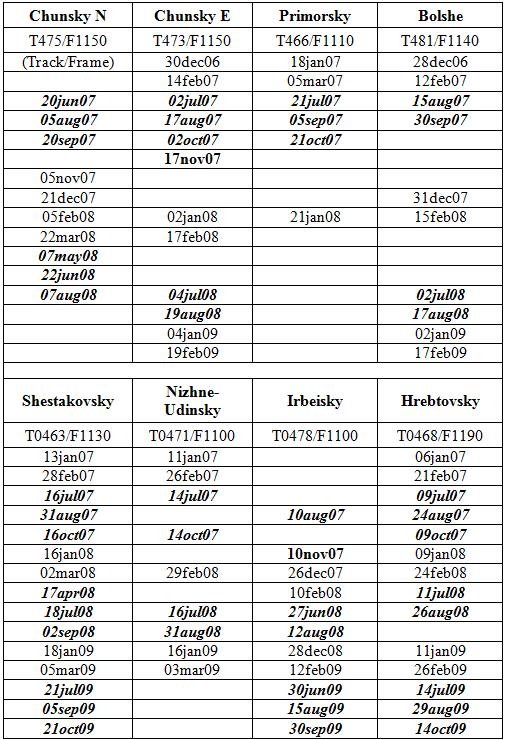
29 Thank you! 1 no stretching applied on image data 0 20jun07_05aug07 21dec07_05feb08 05nov07_20jun07 Coherence Images Examples Chunsky N (Temp. Baseline 46 d)
Product Delivery Report for K&C Phase 3. Christian Thiel et al. Friedrich-Schiller-University Jena, Germany
 Product Delivery Report for K&C Phase 3 Christian Thiel et al. Friedrich-Schiller-University Jena, Germany Science Team meeting #21 Phase 3 Result Presentations Kyoto Research Park, Kyoto, Japan, December
Product Delivery Report for K&C Phase 3. Maurizio Santoro. GAMMA Remote Sensing
 Product Delivery Report for K&C Phase 3 Maurizio Santoro GAMMA Remote Sensing Science Team meeting #21 Phase 3 Result Presentations Kyoto Research Park, Kyoto, Japan, December 3-4, 2014 Nuno Carvalhais,
Report on Kyoto & Carbon Initiative Project Change detection in Swedish forest
 Report on Kyoto & Carbon Initiative Project Change detection in Swedish forest Johan Fransson, Anders Krantz, Mattias Magnusson and Håkan Olsson Swedish University of Agricultural Sciences, Sweden Leif
ASSESSMENT AND MONITORING OF FOREST RESOURCES IN THE FRAMEWORK OF THE EU-RUSSIAN SPACE DIALOGUE THE ZAPÁS PROJECT
 Friedrich-Schiller-University Jena Institute for Geography Earth Observation ASSESSMENT AND MONITORING OF FOREST RESOURCES IN THE FRAMEWORK OF THE EU-RUSSIAN SPACE DIALOGUE THE ZAPÁS PROJECT 2011-14 C.C.
Forest Applications. Chris Schmullius, Oliver Cartus, Maurizio Santoro. 5 September 2007, D3PB
 Forest Applications Chris Schmullius, Oliver Cartus, Maurizio Santoro 5 September 2007, D3PB 4 September 2007 D3PB-2 Forest practicals Christiane Schmullius 2 Einführung mit C/X-Äthna-Beispielen MFFU Sommerschule
K&C Phase 4 Status report. Retrieval of forest biomass and biomass change with spaceborne SAR
 K&C Phase 4 Status report Retrieval of forest biomass and biomass change with spaceborne SAR Johan Fransson 1, Jonas Fridman 1, Ivan Huuva, Håkan Olsson 1, Henrik J. Persson 1, Jörgen Wallerman 1, Maurizio
Product Delivery Report for K&C Phase 3. Francesco Holecz sarmap
 Product Delivery Report for K&C Phase 3 Francesco Holecz sarmap Science Team meeting #21 Phase 3 Result Presentations Kyoto Research Park, Kyoto, Japan, December 3-4, 2014 Project objectives The objective
K&C Initiative, Extension Phase : Mapping and monitoring of forests in Sweden using ALOS PALSAR data
 K&C Initiative, Extension Phase 2009-2011: Mapping and monitoring of forests in Sweden using ALOS PALSAR data Johan Fransson and Håkan Olsson Swedish University of Agricultural Sciences, Sweden Leif Eriksson
DEMONSTRATING THE POTENTIAL OF ALOS PALSAR BACKSCATTER AND INSAR COHERENCE FOR FOREST GROWING STOCK VOLUME ESTIMATION IN CENTRAL SIBERIA
 DEMONSTRATING THE POTENTIAL OF ALOS PALSAR BACKSCATTER AND INSAR COHERENCE FOR FOREST GROWING STOCK VOLUME ESTIMATION IN CENTRAL SIBERIA Christian Thiel, Christiane Schmullius Department for Earth Observation,
Forest Applications. Christiana Schmullius. 2 July 2009
 Forest Applications Christiana Schmullius 2 July 29 Contents Motivation Need for Biomass Mapping Biomass Components Physical Background Wavelength Polarisation Coherence Mapping Results Siberia: Coherence
K&C Phase 4 Status report. Retrieval of forest biomass and biomass change with spaceborne SAR
 K&C Phase 4 Status report Retrieval of forest biomass and biomass change with spaceborne SAR Johan Fransson 1, Jonas Fridman 1, Ivan Huuva 1 Håkan Olsson 1, Henrik Persson 1, Jörgen Wallerman 1, Maurizio
ALOS K&C Activities in Sweden
 ALOS K&C Activities in Sweden Dr. Johan Fransson, Dr. Mattias Magnusson, Prof. Håkan Olsson (SLU) Prof. Lars Ulander, Dr. Leif Eriksson, Klas Folkesson, Gustaf Sandberg Chalmers University of Technology
FOREST DRAGON 2: LARGE-AREA FOREST GROWING STOCK VOLUME MAPPING IN CHINA, USING SPACEBORNE RADAR
 FOREST DRAGON 2: LARGE-AREA FOREST GROWING STOCK VOLUME MAPPING IN CHINA, USING SPACEBORNE RADAR Johannes Reiche (1), Reik Leiterer (1), Oliver Cartus (1), Maurizio Santoro (2), Christiane Schmullius (1),
Mapping Scotland with PALSAR: An Assessment of the Importance of L-Band Polarimetry
 Mapping Scotland with PALSAR: An Assessment of the Importance of L-Band Polarimetry Shane R. Cloude, AEL Consultants,Scotland, UK E-mail : aelc@mac.com Web :http://web.mac.com/aelc Iain H Woodhouse (2),
A SEMI-AUTOMATIC AND MULTISCALE APPROACH FOR ASSESSING THE AGREEMENT OF LARGE SCALE FOREST MAPS
 10 Sept. 10 D5L1 Forestry SAR Part II Chris Schmullius 1 A SEMI-AUTOMATIC AND MULTISCALE APPROACH FOR ASSESSING THE AGREEMENT OF LARGE SCALE FOREST MAPS R. Leiterer 1, J. Reiche 1, O. Cartus 1, M. Santoro
ESTIMATION OF FOREST STRUCTURAL PARAMETERS FROM LIDAR AND SAR DATA
 ESTIMATION OF FOREST STRUCTURAL PARAMETERS FROM LIDAR AND SAR DATA Z. Zhang a, b,*, W. Ni b, A. Fu b, Z. Guo b, Guoqing Sun c, and D. Wang b a Remote Sensing and GIS Research Center, Beijing Normal University,
K&C Phase 4 Status report. Coupling radar-based estimates of forest information with biosphere models for improved carbon flux estimation
 K&C Phase 4 Status report Coupling radar-based estimates of forest information with biosphere models for improved carbon flux estimation Maurizio Santoro & Oliver Cartus GAMMA Remote Sensing Nuno Carvalhais
K&C Science Report Phase 1 Change in forest cover in Central Siberia using ALOS/PALSAR
 K&C Science Report Phase 1 Change in forest cover in Central Siberia using ALOS/PALSAR Thuy Le Toan Centre d Etudes Spatiales de la Biosphère 18 Avenue Edouard Belin, 31401 Toulouse Cedex 9, France Thuy.Letoan@cesbio.cnes.fr
RADAR for Biomass Mapping
 RADAR for Biomass Mapping Josef Kellndorfer Wayne Walker, Katie Kirsch, Greg Fiske The Woods Hole Research Center GOFC-GOLD Biomass Workshop Missoula, 15-June-2009 Outline Some Radar principles Measurements
Chalmers Publication Library
 Chalmers Publication Library Estimation of Forest Stem Volume using ALOS-2 PALSAR-2 Satellite Images This document has been downloaded from Chalmers Publication Library (CPL). It is the author s version
K&C Phase 4 Brief project essentials
 K&C Phase 4 Brief project essentials Measuring above-ground biomass and its changes over Brazilian tropical secondary forests and savanna woodlands (Cerrado) using L-band SAR data Shaun Quegan, João Carreiras
VALIDATION OF HEIGHTS FROM INTERFEROMETRIC SAR AND LIDAR OVER THE TEMPERATE FOREST SITE NATIONALPARK BAYERISCHER WALD
 VALIDATION OF HEIGHTS FROM INTERFEROMETRIC SAR AND LIDAR OVER THE TEMPERATE FOREST SITE NATIONALPARK BAYERISCHER WALD T. Aulinger (1,3), T. Mette (1), K.P. Papathanassiou (1), I. Hajnsek (1), M. Heurich
Epsilon Open Archive
 This is an article in conference proceedings from the conference IGARSS 2016 Symposium, Advancing the understanding of our living planet, Beijing, China, 10-15 July. This paper has been peer-reviewed but
K&C Phase 3 Brief project essentials. Wide area forest monitoring of Insular SE Asia and Guiana Shield. Dirk Hoekman Wageningen University
 K&C Phase 3 Brief project essentials Wide area forest monitoring of Insular SE Asia and Guiana Shield Dirk Hoekman Wageningen University Science Team meeting #16 Phase 3 Kick-off JAXA TKSC/RESTEC HQ, Tsukuba/Tokyo,
Malawi Multi-purpose use of ALOS PALSAR-1 data. sarmap and Forest Research Institute of Malawi (FRIM)
") Malawi Multi-purpose use of ALOS PALSAR-1 data sarmap and Forest Research Institute of Malawi (FRIM) Objective The objective is to demonstrate, at country-level, the multi-purpose use of ALOS PALSAR-1
Malawi Multi-purpose use of ALOS PALSAR-1 data sarmap and Forest Research Institute of Malawi (FRIM) Objective The objective is to demonstrate, at country-level, the multi-purpose use of ALOS PALSAR-1
Polar Space Task Group Permafrost Review of Requirements, Achievements and Expected Data
 Polar Permafrost Review of Requirements, Achievements and Expected Data Annett Bartsch Central Institute for Meteorology and Geodynamics, Vienna, Austria PSTG 6, ESTEC, Sept., 2016 Developments since last
SAR Tomographic imaging of tropical forests: P and L-band
 SAR Tomographic imaging of tropical forests: P and L-band Dinh Ho Tong Minh 1, Thuy Le Toan 1, Stefano Tebaldini 2, Fabio Rocca 2 (1) Centre d Ėtudes Spatiales de la Biosphère (CESBIO), Toulouse, France
TropiSAR data analysis and biomass inversion
 TropiSAR data analysis and biomass inversion Thuy Le Toan, Ludovic Villard, Yannick Lasne,Thierry Koleck CESBIO Toulouse, France Réunion TOSCA-TropiSAR 19-20 January 2011 Outline Data analysis Revisiting
Product Delivery Report for K&C Phase 3. Wide area forest monitoring of Insular SE Asia and Guiana Shield. Dirk Hoekman Wageningen University
 Product Delivery Report for K&C Phase 3 Wide area forest monitoring of Insular SE Asia and Guiana Shield Dirk Hoekman Wageningen University Martin Vissers and Marcela Quiñones, SarVision Hidayat and Johannes
ALOS Kyoto & Carbon Initiative Brief (forest) summary for GlobBiomass. Ake Rosenqvist, K&C Science Coordinator
 summary for GlobBiomass. Ake Rosenqvist, K&C Science Coordinator") ALOS Kyoto & Carbon Initiative Brief (forest) summary for GlobBiomass Ake Rosenqvist, K&C Science Coordinator Heritage and objectives The ALOS Kyoto & Carbon Initiative is a JAXA-led international collaboration,
ALOS Kyoto & Carbon Initiative Brief (forest) summary for GlobBiomass Ake Rosenqvist, K&C Science Coordinator Heritage and objectives The ALOS Kyoto & Carbon Initiative is a JAXA-led international collaboration,
Gazing at Grass: Estimating surface deformation over fast decorrelating pasture using InSAR
 Gazing at Grass: Estimating surface deformation over fast decorrelating pasture using InSAR Yu Morishita and Ramon Hanssen 1 60% below the highwater levels of the sea, river, and lakes: Flood risk is the
Forest Dragon 3 Project Id
 Forest Dragon 3 Project Id. 10666 Principle Investigator: Co-Investigator: Young Scientists: Prof. Li, Academy of Forest Sciences Prof. Schmullius, University of Jena Prof. Pang, Dr. Feilong, Dr. Santoro
Hydrological analysis of high resolution multifrequent, multipolarimetric and interferometric airborne SAR data
 Hydrological analysis of high resolution multifrequent, multipolarimetric and interferometric airborne SAR data VOLKER HOCHSCHILD, MARTIN HEROLD Institute for Geography, Department of Geoinformatics, Hydrology
SUBSIDENCE MEASUREMENT WITH PS-INSAR TECHNIQUES IN SHANGHAI URBAN
 SUBSIDENCE MEASUREMENT WITH PS-INSAR TECHNIQUES IN SHANGHAI URBAN Lijun Lu Mingsheng Liao State Key Laboratory for Information Engineering in Survey, Mapping and Remote Sensing,Wuhan University Luoyu Road
BIOMASS. * US Observers
 1 BIOMASS Malcolm Davidson, A. Thompson, C. Lin, P. Benzi, F. Heliere (ESA-ESTEC) and the BIOMASS MAG (T. Le Toan, S. Quegan, H. Baltzer, P. Paillou, K. Papathanassiou, F. Rocca, L. Ulander, S. Plummer,
K&C Phase 3 Brief project essentials
 K&C Phase 3 Brief project essentials Aboveground Biomass and Carbon Stock Mapping and Changes Monitoring in the Forest of Peninsular Malaysia Using L-Band ALOS Palsar and JERS-1 Khali Aziz Hamzah & Hamdan
Applications of SAR Polarimetry on Land: Soil Moisture and Wetlands
 Applications of SAR Polarimetry on Land: Soil Moisture and Wetlands Session Summary and Recommendations R. Touzi and S. Cloude Session Summary T. Jagdhuber et. Al.: Polarimetric Decompositions for Soil
FOREST AND FOREST CHANGE MAPPING WITH C- AND L-BAND SAR IN LIWALE, TANZANIA
 FOREST AND FOREST CHANGE MAPPING WITH C- AND L-BAND SAR IN LIWALE, TANZANIA J. Haarpaintner a, C. Davids a, H. Hindberg a, E. Zahabu b, R.E. Malimbwi b a Norut, P.O. Box 6434, Tromsø Science Park, N-9294
Remote Sensing of Mangrove Structure and Biomass
 Remote Sensing of Mangrove Structure and Biomass Temilola Fatoyinbo 1, Marc Simard 2 1 NASA Goddard Space Flight Center, Greenbelt, MD USA 2 NASA Jet Propulsion Laboratory, Pasadena, CA USA Introdution
the wheat fields is small, and as for fields of puddling and leveling in winter and other fields in similar, the difference is small. It is conclude t
 OBSERVATION OF JAPANESE PADDY RICE FIELDS USING MULTI TEMPORAL AND POLARIMETRIC PALSAR DATA PI No.365 Naoki ISHITSUKA 1, Genya SAITO 2, Fan YANG 3, Chinatsu YONEZAWA 4 and Shigeo OGAWA 5 1 National Institute
Forest & Agriculture Mapping using SAR
 Forest & Agriculture Mapping using SAR Prof. Dr. Christiana Schmullius Dr. Oliver Cartus (Woodshole Research Center), Tanja Riedel (University Jena) Dr. Maurizio Santoro (Gamma Remote Sensing), Dr. Christian
IEEE TRANSACTIONS ON GEOSCIENCE AND REMOTE SENSING 1
 IEEE TRANSACTIONS ON GEOSCIENCE AND REMOTE SENSING 1 TanDEM-X Pol-InSAR Performance for Forest Height Estimation Florian Kugler, Daniel Schulze, Irena Hajnsek, Fellow, IEEE, Hans Pretzsch, and Konstantinos
The Biomass mission How it works, what it measures? Thuy Le Toan, CESBIO, Toulouse, France & The Biomass Mission Advisory Group
 The Biomass mission How it works, what it measures? Thuy Le Toan, CESBIO, Toulouse, France & The Biomass Mission Advisory Group Why Synthetic Aperture Radars to observe the world forests? Transmit and
Radar Polarimetry for Forestry Applications: ALOS and Radarsat-2 studies in Canada
 Radar Polarimetry for Forestry Applications: ALOS and Radarsat-2 studies in Canada by S. R. Cloude (1), A. Marino (2), D. Goodenough (3), H Chen (3), A. Richardson (3), B. Moa (4) (1) AEL Consultants,
Assessment of tropical forest biomass: A challenging objective for the Biomass mission
 Assessment of tropical forest biomass: A challenging objective for the Biomass mission Thuy Le Toan, Ludovic Villard, Ho Tong M. D., Thierry Koleck, CESBIO, Toulouse, France Pascale Dubois Fernandez, ONERA,
Biomass Level-2 DATE: ISSUE: AUTHOR: Wednesday, 30 May 2018 Issue 1.0. Francesco Banda
 Biomass Level-2 DATE: ISSUE: AUTHOR: Wednesday, 30 May 2018 1.0 Francesco Banda 2 Level-2 implementation study 3 BIOMASS mission ESAs 7th Earth Explorer studying the forested areas of our planet launch
THE PHASED Array type L-band Synthetic Aperture
 IEEE TRANSACTIONS ON GEOSCIENCE AND REMOTE SENSING, VOL. 47, NO. 12, DECEMBER 2009 4001 Signatures of ALOS PALSAR L-Band Backscatter in Swedish Forest Maurizio Santoro, Member, IEEE, Johan E. S. Fransson,
Model-Based Biomass Estimation of a Hemi-Boreal Forest from Multitemporal TanDEM-X Acquisitions
 Remote Sens. 2013, 5, 5574-5597; doi:10.3390/rs5115574 Article OPEN ACCESS Remote Sensing ISSN 2072-4292 www.mdpi.com/journal/remotesensing Model-Based Biomass Estimation of a Hemi-Boreal Forest from Multitemporal
Multitemporal Repeat-Pass SAR Interferometry of Boreal Forests
 1540 IEEE TRANSACTIONS ON GEOSCIENCE AND REMOTE SENSING, VOL. 41, NO. 7, JULY 2003 Multitemporal Repeat-Pass SAR Interferometry of Boreal Forests Jan Askne, Life Senior Member, IEEE, Maurizio Santoro,
Integration of Alos PalSAR and LIDAR IceSAT data in a multistep approach for wide area biomass mapping
 Integration of Alos PalSAR and LIDAR IceSAT data in a multistep approach for wide area biomass mapping. Above Ground Biomass (carbon) mapping and monitoring: Importance Supporting UNFCC KP, REDD+, Monitoring
QUANTATAIVE ANALYSIS OF RELATIONSHIP BETWEEN ALOS PALSAR BACKSCATTER AND FOREST STAND VOLUME
 624 Journal of Marine Science and Technology, Vol. 2, No. 6, pp. 62428 (212) DOI: 1.6119/JMST-12-42-1 QUANTATAIVE ANALYSIS OF RELATIONSHIP BETWEEN ALOS PALSAR BACKSCATTER AND FOREST STAND VOLUME Choen
ALOS K&C Project updated
 ALOS K&C Project updated Thuy Le Toan CESBIO, France 1. Forest products: forest and biomass maps 2. Wetlands products: rice maps inundation maps Forest and forest biomass maps K&C product(s): Algorithms
The BIOMASS mission An ESA Earth Explorer candidate to measure the BIOMASS of the earth's forests
 Downloaded from orbit.dtu.dk on: May 08, 2018 The BIOMASS mission An ESA Earth Explorer candidate to measure the BIOMASS of the earth's forests Scipal, K.; Arcioni, M.; Chave, J.; Dall, Jørgen; Fois, F.;
Tropical Forest Mapping using Multiband Polarimetric and Interferometric SAR Data
 Tropical Forest Mapping using Multiband Polarimetric and Interferometric SAR Data Kemal Unggul Prakoso Wageningen University, Nieuwe Kanaal 11, 6709 PA Wageningen, The Netherlands tel:+31-317-483576, fax:+31-317-484885,
Use of multi-temporal PalSAR ScanSAR data for soil moisture retrieval
 Use of multi-temporal PalSAR ScanSAR data for soil moisture retrieval Francesco Mattia (1), Giuseppe Satalino (1), Anna Balenzano (1) and Michele Rinaldi () (1) Consiglio Nazionale delle Ricerche (CNR)
Forest Biomass Estimation, Australia
 Forest Biomass Estimation, Australia 1 Richard Lucas, 2 John Armston, 1 Peter Bunting, 1 Daniel Clewley, 2 Peter Scarth, 2 Michael Schmidt, 2 Arnon Accad, 3 Paul Siqueira and 3 Yang Lei 1 Institute of
Globbiomass: new products and approaches
 Globbiomass: new products and approaches Global mapping of forest biomass: status-quo Maurizio Santoro 1, Oliver Cartus 1, GAMMA Remote Sensing Thuy Le Toan 2, Stephane Mermoz 2, Alexandre Bouvet 2, Ludovic
Forest Changes and Biomass Estimation
 Forest Changes and Biomass Estimation Project Title: Comparative Studies on Carbon Dynamics in Disturbed Forest Ecosystems: Eastern Russia and Northeastern China Supported by NASA Carbon Cycle Science
ANALYSIS OF ALOS/PALSAR POLARIMETRIC SIGNATURES AND SCATTERING MECHANISMS OF FOREST TYPES IN TAPAJÓS S REGION, BRAZIL
 ANALYSIS OF ALOS/PALSAR POLARIMETRIC SIGNATURES AND SCATTERING MECHANISMS OF FOREST TYPES IN TAPAJÓS S REGION, BRAZIL J. R. dos Santos 1 ; I. S. Narvaes 1.; P. M. L. A. Graça 2 ; F. G. Gonçalves 3 (1)
LAND SUBSIDENCE MAPPING WITH ERS INTERFEROMETRY: EVALUATION OF MATURITY AND OPERATIONAL READINESS
 LAND SUBSIDENCE MAPPING WITH ERS INTERFEROMETRY: EVALUATION OF MATURITY AND OPERATIONAL READINESS URS WEGMULLER, TAZIO STROZZI, ANDREAS WIESMANN, AND CHARLES WERNER Gamma Remote Sensing, Thunstrasse 130,
PACRIM-2 Clear-fell Mapping Studies in New Zealand
 PACRIM-2 Clear-fell Mapping Studies in New Zealand D. Pairman, S.J. McNeill, D. McNab* and S.E. Belliss Landcare Research PO Box 69, Lincoln 8152, New Zealand. *Fletcher Challenge Forests. Email: pairmand@landcareresearch.co.nz
PALSAR TROPICAL FOREST COVER MAPPING, MOSAICING AND VALIDATION, CASE STUDY BORNEO
 PALSAR TROPICAL FOREST COVER MAPPING, MOSAICING AND VALIDATION, CASE STUDY BORNEO Dirk H. Hoekman 1), M.J. Quiñones 2), R. Verhoeven 2), M.A.M. Vissers 2), V. Schut 2) and N. Wielaard 2) 1) Wageningen
Using multi-temporal ALOS PALSAR to investigate flood dynamics in semi-arid wetlands: Murray Darling Basin, Australia.
 Using multi-temporal ALOS PALSAR to investigate flood dynamics in semi-arid wetlands: Murray Darling Basin, Australia. Rachel Melrose, Anthony Milne Horizon Geoscience Consulting and University of New
ALOS Kyoto & Carbon Initiative Brief intro for potential new members. Ake Rosenqvist for JAXA
 ALOS Kyoto & Carbon Initiative Brief intro for potential new members Ake Rosenqvist for JAXA K&C January, 2011 Outline 1. Heritage and objectives 2. Project organization 3. Data- and information requirements
MOLI Science Plan. Forestry and Forest Products Research Institute Yasumasa Hirata
 International Workshop on Vegetation Lidar and Application from Space May 26, 2017 MOLI Science Plan Forestry and Forest Products Research Institute Yasumasa Hirata Current Global Issues Contributions
JAXA s MRV - current status and future envision -
 JAXA s MRV - current status and future envision - Masanobu Shimada Japan Aerospace Exploration Agency Earth Observation Research Center MRV symposium at Tokyo Forum Feb. 17, 2011 Concept Satellite data
CROP SPECIES RECOGNITION AND DISCRIMINATION PADDY-RICE-GROWING- FIELDS FROM REAPED-FIELDS BY THE RADAR VEGETATION INDEX (RVI) OF ALOS-2/PALSAR2
 OF ALOS-2/PALSAR2") CROP SPECIES RECOGNITION AND DISCRIMINATION PADDY-RICE-GROWING- FIELDS FROM REAPED-FIELDS BY THE RADAR VEGETATION INDEX (RVI) OF ALOS-2/PALSAR2 Y. Yamada a a Institute for Rural Engineering, National Agriculture
CROP SPECIES RECOGNITION AND DISCRIMINATION PADDY-RICE-GROWING- FIELDS FROM REAPED-FIELDS BY THE RADAR VEGETATION INDEX (RVI) OF ALOS-2/PALSAR2 Y. Yamada a a Institute for Rural Engineering, National Agriculture
Airborne Campaigns for Pol-InSAR Applications Development
 Airborne Campaigns for Pol-InSAR Applications Development Irena Hajnsek, Alberto Moreira, Malcolm Davidson German Aerospace Center European Space Agency Folie 1 irena.hajnsek@dlr.de - 22.01.2007 Outline
K&C Phase 4 Brief project essentials. Asia-RiCE: Rice Crop Estimation and Monitoring. Shin-ichi Sobue Remote Sensing Technology Center of Japan
 K&C Phase 4 Brief project essentials Asia-RiCE: Rice Crop Estimation and Monitoring Shin-ichi Sobue Remote Sensing Technology Center of Japan Science Team meeting #21 Phase 4 Kick-off Kyoto Research Park,
Tropical forest mapping and change detection using ALOS PALSAR data
 Tropical forest mapping and change detection using ALOS PALSAR data Wenmei Li a, Qi Feng a, Erxue Chen a, Zengyuan Li *a a The research institute of forest resources information technique, Chinese Academy
Forest Disturbances Requirements of Biomass Datasets
 CENTRE FOR LANDSCAPE AND CLIMATE RESEARCH Forest Disturbances Requirements of Biomass Datasets Heiko Balzter Pedro Rodriguez-Veiga 1 st ESA CCI Biomass Workshop, Paris, France 25-26 September 2018 Biomass
Polarimetric SAR Interferometry: Potential and Limitations for Biomass Estimation
 Polarimetric SAR Interferometry: Potential and Limitations for Biomass Estimation K. P. Papathanassiou, T. Mette, I. Hajnsek & A. Moreira Pol-InSAR Research Group (DLR) (DLR-HR) Oberpfaffenhofen, PO. 1116,
RADAR INTERFEROMETRIC ANALYSIS OF MINING INDUCED SURFACE SUBSIDENCE USING PERMANENT SCATTERER
 RADAR INTERFEROMETRIC ANALYSIS OF MINING INDUCED SURFACE SUBSIDENCE USING PERMANENT SCATTERER D. Walter 1, J. Hoffmann 2, B. Kampes 3, and A. Sroka 1 1 University of Mining and Technology, Department of
Assessment of stand-wise stem volume retrieval in boreal forest from JERS-1 L-band SAR backscatter
 International Journal of Remote Sensing Vol. 27, No. 16, 20 August 2006, 3425 3454 Assessment of stand-wise stem volume retrieval in boreal forest from JERS-1 L-band SAR backscatter M. SANTORO 1 {, L.
Forest Management Mapping, monitoring, and inference of biophysical parameters using ALOS PALSAR and Cosmo-SkyMed data
 Forest Management Mapping, monitoring, and inference of biophysical parameters using ALOS PALSAR and Cosmo-SkyMed data Francesco Holecz 1, Massimo Barbieri 1, Charles Eyre 2, and Nico Mönnig 3 1 sarmap
Science I EARTH EXPLORER 7 USER CONSULTATION MEETING. An Earth Explorer to observe forest biomass
 Science I EARTH EXPLORER 7 USER CONSULTATION MEETING An Earth Explorer to observe forest biomass Primary Mission Objectives 1. Reducing the major uncertainties in carbon fluxes linked to Land Use Change,
FOREST HEIGHT ESTIMATES FOR BOREAL FOREST USING L- AND X-BAND POLINSAR AND HUTSCAT SCATTEROMETER
 FOREST HEIGHT ESTIMATES FOR BOREAL FOREST USING L- AND X-BAND POLINSAR AND HUTSCAT SCATTEROMETER Jaan Praks 1, Florian Kugler 2, Konstantinos Papathanassiou 2, and Martti Hallikainen 1 1 Laboratory of
LiDAR/SAR-based mapping of savannahs forests in Southern Africa
 Joint GFOI / GOFC-GOLD / CONABIO / SilvaCarbon R&D Expert and Capacity Building workshop on: Regional solutions to forest type stratification and characterising the forest state for national forest monitoring
Regional Mapping and Monitoring Rice Production and Greenhouse Gas Emissions in Asia with PALSAR
 Regional Mapping and Monitoring Rice Production and Greenhouse Gas Emissions in Asia with PALSAR William Salas 1, Nathan Torbick 1, Changsheng Li 2 and Xiangming Xiao 2 1 Applied Geosolutions, LLC, 87
SAR time series in forest research Biomass
 SAR time series in forest research Biomass Thuy Le Toan Centre D Etudes Spatiales de la Biosphere (CESBIO) Toulouse, France Thuy.Letoan@cesbio.cnes.fr The research question on the global Carbon budget
The NASA Soil Moisture Active Passive (SMAP) mission: Overview
 mission: Overview") The NASA Soil Moisture Active Passive (SMAP) mission: Overview The MIT Faculty has made this article openly available. Please share how this access benefits you. Your story matters. Citation As Published
The NASA Soil Moisture Active Passive (SMAP) mission: Overview The MIT Faculty has made this article openly available. Please share how this access benefits you. Your story matters. Citation As Published
APPROACHES TO KYOTO AFFORESTATION, REFORESTATION AND DEFORESTATION MAPPING IN SIBERIA USING OBJECT ORIENTED CHANGE DETECTION METHODS
 APPROACHES TO KYOTO AFFORESTATION, REFORESTATION AND DEFORESTATION MAPPING IN SIBERIA USING OBJECT ORIENTED CHANGE DETECTION METHODS S. Hese and C. Schmullius Friedrich-Schiller University Jena, Löbdergraben
GFOI Plenary/SDCG 11. GFOI R&D Groups. Martin Herold, Brice Mora (GOFC-GOLD) Anthea Mitchell (UNSW) Ake Rosenqvist (soloeo)
 Anthea Mitchell (UNSW) Ake Rosenqvist (soloeo)") GFOI Plenary/SDCG 11 GFOI R&D Groups Martin Herold, Brice Mora (GOFC-GOLD) Anthea Mitchell (UNSW) Ake Rosenqvist (soloeo) Defining research priorities & stimulating R&D Country needs and priorities UN-REDD,
GFOI Plenary/SDCG 11 GFOI R&D Groups Martin Herold, Brice Mora (GOFC-GOLD) Anthea Mitchell (UNSW) Ake Rosenqvist (soloeo) Defining research priorities & stimulating R&D Country needs and priorities UN-REDD,
K&C Phase 4 Status report
 K&C Phase 4 Status report Measuring above ground biomass and changes over Brazilian tropical secondary forests and savanna woodlands (Cerrado) using L-band SAR data Shaun Quegan, João Carreiras National
3/1/18 USING RADAR FOR WETLAND MAPPING IMPORTANCE OF SOIL MOISTURE TRADITIONAL METHODS TO MEASURE SOIL MOISTURE. Feel method Electrical resistance
 3/1/18 USING RADAR FOR WETLAND MAPPING SOIL MOISTURE AND WETLAND CLASSIFICATION Slides modified from a presentation by Charlotte Gabrielsen for this class. Southeast Arizona: Winter wet period From C.
AGRICULTURAL PERFORMANCE MONITORING WITH POLARIMETRIC SAR AND OPTICAL IMAGERY
 AGRICULTURAL PERFORMANCE MONITORING WITH POLARIMETRIC SAR AND OPTICAL IMAGERY Tishampati Dhar [1][2], Doug Gray [1], Carl Menges [2] [1] Dept of Electrical and Electronic Engineering, University of Adelaide,
K&C Science Report Phase 2 ALOS-PALSAR Indonesia Forest Monitoring Project
 K&C Science Report Phase 2 ALOS-PALSAR Indonesia Forest Monitoring Project Shaun Quegan, Martin Whittle CTCD, University of Sheffield, Hicks building, Hounsfield Rd, Sheffield S3 7RH s.quegan@sheffield.ac.uk,
Overview of Land Surface Parameters From Earth Observation
 Overview of Land Surface Parameters From Earth Observation Prof. Dr. Christiane Schmullius Friedrich Schiller University Jena, Germany Department of Geoinformatics and Remote Sensing FSU Jena Institut
The Use of C- and L-Band Repeat-Pass Interferometric SAR Coherence for Soil Moisture Change Detection in Vegetated Areas
 The Open Remote Sensing Journal, 2012, 5, 37-53 37 Open Access The Use of C- and L-Band Repeat-Pass Interferometric SAR Coherence for Soil Moisture Change Detection in Vegetated Areas Brian Barrett*,1,
Etude du potentiel de l interférométrie radar pour la foresterie. «ERS INSAR data for remote sensing over hilly forested areas»
 $11(;(, Etude du potentiel de l interférométrie radar pour la foresterie. «ERS INSAR data for remote sensing over hilly forested areas» T. Castel, J.M. Martinez, A. Beaudoin, U. Wegmuller, T. Strozzi Remote
Product Delivery Report for K&C Phase 3. Nathan Torbick, William Salas Applied Geosolutions. Collaborators: J. Dong, M. Ducey, C. Li, J. Qi, X.
 Product Delivery Report for K&C Phase 3 Nathan Torbick, William Salas Applied Geosolutions Collaborators: J. Dong, M. Ducey, C. Li, J. Qi, X. Xiao Science Team meeting #21 Phase 3 Result Presentations
INTEGRATED RADAR INTERFEROMETRY FOR GROUND SUBSIDENCE MONITORING
 INTEGRATED RADAR INTERFEROMETRY FOR GROUND SUBSIDENCE MONITORING Linlin Ge (1), Hsing-Chung Chang (1), John Trinder (1), and Chris Rizos (1) (1) School of Surveying & Spatial Information Systems, The University
Soil Moisture Validation in the U.S.
 Soil Moisture Validation in the U.S. T. J. Jackson, R. Bindlish, I. Mladenova, and M. Cosh USDA ARS Hydrology and Remote Sensing Lab January 16, 2014 Outline Project Overview GCOM-W AMSR2 Brightness Temperature
Joint GFOI/GOFC-GOLD Expert Workshop 2: Approaches to monitoring forest degradation for REDD+
 Joint GFOI/GOFC-GOLD Expert Workshop 2: Approaches to monitoring forest degradation for REDD+ Forest carbon monitoring for REDD MRV with satellite 3D SAR Svein Solberg Norwegian Forest and Landscape Institute
William Salas Applied GeoSolutions (AGS) Durham, NH USA,
 Durham, NH USA,") K&C Phase 3 Brief project essentials Application of PALSAR for regional assessments of forest disturbance, rice agriculture and wetland habitats. William Salas Applied GeoSolutions (AGS) Durham, NH USA,
K&C Phase 3 Brief project essentials Application of PALSAR for regional assessments of forest disturbance, rice agriculture and wetland habitats. William Salas Applied GeoSolutions (AGS) Durham, NH USA,
carbon cycle Ulander 11
 5 Final submitted version of: Le Toan, T., Quegan, S., Davidson, M., Balzter, H., Paillou, P., Papathanassiou, K., Plummer, S., Rocca, F., Saatchi, S., Shugart, H. and Ulander, L. (2011): The BIOMASS Mission:
The Penetration Depth Derived from the Synthesis of ALOS/PALSAR InSAR Data and ASTER GDEM for the Mapping of Forest Biomass
 Remote Sens. 2014, 6, 7303-7319; doi:10.3390/rs6087303 Article OPEN ACCESS remote sensing ISSN 2072-4292 www.mdpi.com/journal/remotesensing The Penetration Depth Derived from the Synthesis of ALOS/PALSAR
ERS COHERENCE AND SLC IMAGES IN FOREST CHARACTERISATION
 ERS COHERENCE AND SLC IMAGES IN FOREST CHARACTERISATION Manninen, T. (1), Parmes, E. (1), Häme, T. (1), Sephton, A. (1), Bach, H. (2) and Borgeaud, M. (3) (1) VTT Automation, Remote Sensing P.O. Box, 134,
Distributed Mapping of SNTHERM-Modelled Snow Properties for Monitoring Seasonal Freeze/Thaw Dynamics
 58th EASTERN SNOW CONFERENCE Ottawa, Ontario, Canada, 2001 Distributed Mapping of SNTHERM-Modelled Snow Properties for Monitoring Seasonal Freeze/Thaw Dynamics JANET P. HARDY 1, KYLE MCDONALD 2, ROBERT
Forest Height Estimation with X- Band InSAR: Phase Centre Location versus RVoG
 Forest Height Estimation with X- Band InSAR: Phase Centre Location versus RVoG Florian Kugler, Irena Hajnsek, Seung-Kuk Lee & Konstantinos Papathanassiou German Aerospace Center (DLR) Microwaves and Radar