FOREST BIOMASS & CARBON STOCKS MAPPING USING SATELLITE IMAGERIES & ISSUES RELATING TO REDD+ IN MALAYSIA
|
|
|
- Duane Mathews
- 6 years ago
- Views:
Transcription

1 FOREST BIOMASS & CARBON STOCKS MAPPING USING SATELLITE IMAGERIES & ISSUES RELATING TO REDD+ IN MALAYSIA Hamdan Omar GeoInformation Programme Division of Forestry and Environment, FRIM Workshop on Methods for Biomass Estimation and Forest-Cover Mapping Woods Hole Research Center 8-12 October 2010 Center for Climate Change Studies, University of Mulawarman, Indonesia
2 Presentation Outline What have we done What are we planning to do REDD+: Malaysia s perspective 2
3 1 ALOS PALSAR SATELLITE IMAGE FOR TROPICAL FOREST CARBON STOCK MAPPING Hamdan Omar, Mohd Azahari Faidi & Khali Aziz Hamzah Proc. STSS June 2010, MS Garden Kuantan 2 L-BAND SAR SATELLITE IMAGE FOR TROPICAL FOREST BIOMASS ESTIMATION Hamdan Omar, Khali Aziz Hamzah & Abd Rahman Kassim Journal of Tropical Forest Science (JTFS): Reviewing
4 Objective of Study i) To establish empirical relationship between aboveground carbon stocks and L-band SAR signals, ii) To determine aboveground biomass and carbon stocks of tropical forest by using L-band SAR data, and iii) To identify capability of ALOS PALSAR satellite imagery in estimating aboveground biomass and carbon stocks.
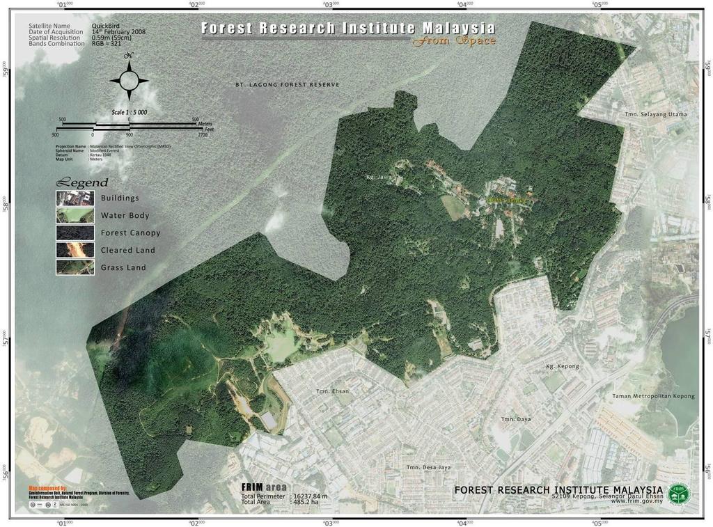
5 Study Area Forest Research Institute Malaysia (FRIM) covers some ha site in Kepong, Selangor. Surrounded by the Bukit Lagong Forest Reserve. Most of the forest trees standing in FRIM area are planted forest. Out of the total area of ha, ha (86.58%) are covered by forest and ha (or 90.4%) of them are planted forest and the remaining ha is natural forest. The age of most of the trees here are about 80 years old, which were planted since year 1929.
6
7 Materials & Methodology Satellite Data The Japanese Advanced Land Observing Satellite (ALOS), which carries polarimetric Phased Array L-band Synthetic Aperture Radar (PALSAR) satellite data was used in this study. ALOS PALSAR image that was used in this research was acquired on 3 rd October 2009 and has spatial resolution of 12 m.
8 Field Inventory Data Field survey was carried out and more than 30 plots of 50 x 50 m size were established within the study area. The plots covered all forest types and various ages. All the trees with the size of dbh of more than five centimetre ( 5 cm) were inventoried.
9 Design of the plots that were distributed and laid on the ground in the study area.


10 NE NW SE PLOT CENTER SW Plots were laid on the ground and the centre coordinate was recorded.


11 Inventory Equipments Diameter Tape DBH measurement Hand held GPS Distance metric tape Hypsometer Laser range for tree height and slope measurements

12 Ground data collection

13 Ground data collection


14 Dominant types of standing trees that are found in the study area. Most of the trees are above 25 m height and reach up to 45 m. High biomass & carbon concentration Medium biomass & carbon concentration Low biomass & carbon concentration
15 Above Ground Biomass Biomass equations to calculate AGB were based on Kato et al. (1978). The allometric function of trees applied in the calculation of standing biomass can be expressed as 1/H = 1/(2.0*D)+1/61 From the values of D and H, the dry mass values of stem, branches and leaves of the tree are estimated. Ms Mb 1/Ml = *(D2H) = 0.136*Ms1.070 = 1/(0.124Ms0.794)+1/125 where; H = total tree height D = stem diameter at breast height (dbh) Ms, Mb and Ml denote the dry mass of stem, branches and leaves respectively.

16 SAR signals at the corresponding plots were sampled out to generate empirical equation. Plot 07 Plot 05 Plot 04 Plot 09

17 Response of SAR to the forest structure Radar band X C L P Wavelength (cm) Main scatterers Leaves, Twigs Leaves, Small branches Branches, Trunk Trunk
18 Relationship between biomass and L-Band ALOS PALSAR signal Strong signal Dense stands High Biomass Weak signal Small stands
19 Results The results found that the live aboveground woody biomass ranged from 25.9 to t ha 1 with the dominant value of t ha-1. All the pixels values were converted into the unit of carbon stocks (t C ha 1 ) and found that the distribution of aboveground carbon stocks of forest within study area range from to t C ha 1.
20 Category Range of Biomass (t/ha) Percentage of Area Coverage (%) Small, growing stands Mixed small & mature stands Mature, dense stands Mature & very dense stands
21
22

 52109 Kepong, Selangor ISFFP 2010 5-7 October")
23 3 FOREST STAND VOLUME ESTIMATION USING SATELLITE SAR IMAGERY Hamdan Omar & Khali Aziz Hamzah Geoinformation Programme, Forestry and Environment Division Forest Research Institute Malaysia (FRIM) Kepong, Selangor ISFFP October 2010, Legend Hotel, KL
24 Merchantable Volume (m^3/ha) Relationship Between ALOS Palsar Backscatter & Stem Volume y = e x R 2 = Forested area Backscatter Coefficient (L-HV, db) 0 Scatter plot that consists of measured stem volume and corresponding SAR signal from PALSAR image.

25 Chengal plot Kapur Kepong Botanic Garden Dip & Non-Dip Arboretum
26 4 TRAINING ON USE OF REMOTE SENSING FOR ASSESSING FOREST BIOMASS & CARBON STOCKS Geoinformation Programme, Environment and Forestry Division Forest Research Institute Malaysia (FRIM) Kepong, Selangor April 2010 FRIM, Kepong


27 Participants listening attentively to the lecture. Participants learning image sampling, modelling & mapping processes Participants brought to the site for field data collection. Participants learning the field data collection process.

28 A photograph of all participants and organisers.

29 A photograph of all participants and organisers.
30 5 CARBON STOCKS MONITORING ON PEAT SWAMP FOREST IN PENINSULAR MALAYSIA: TOWARDS REDD IMPLEMENTATION Proposed for MOA-ScienceFund 26 MEI 2010, FRIM
31 Objectives: i. To update and map the current extents of peat swamp forest in Peninsular Malaysia, ii. To quantify extents and changes of carbon stocks from year 2000 to 2010 on peat swamp forest, iii. To generate spatially distributed map of carbon stock on peat swamp forest over Peninsular Malaysia, and iv. To demonstrate the use of remote sensing techniques in carbon stocks monitoring for the REDD reporting.
, (iii)terengganu (13,000 ha), (iv) Johor")
32 Distribution of PSF in Malaysia: (i) Pahang (200,000 ha), (ii) Selangor (76,000 ha), (iii)terengganu (13,000 ha), (iv) Johor (13,000 ha).
33 Methodology Data acquisitions: A series of SPOT & ALOS PalSAR imagery (2000 & 2010) SPOT image (2000 & 2010) SAR image (2000 & 2010) Field inventory Image Classification Identification of PSF extents in both PRF & Stateland Image Classification Identification of PSF extents in both years Map preparation for peat swamp forests extents (2000 & 2010) Carbon Stocks Mapping - Using carbon stocks equation derived from inventory data and SAR signal Carbon stocks monitoring/mapping Plot-to-image sampling Development of carbon stocks model Carbon stocks changes assessment Validation & Verification Report preparations
34 Output Matrix Objectives Activities Expected Outputs To update and map the current extents of peat swamp forest in Peninsular Malaysia, To quantify extents and changes of carbon stocks from year 2000 to 2010 on peat swamp forest, To generate spatially distributed map of carbon stock on peat swamp forest over Peninsular Malaysia, and To demonstrate the use of remote sensing techniques in carbon stocks monitoring for the REDD reporting. Acquisitions of satellite and ancillary data Satellite image pre-processing Satellite image classification for delineating peat swamp forests Map preparation for peat swamp forests extents. Field inventory Plot-to-image sampling Development of carbon stocks estimation equation Carbon stocks monitoring Gather information derived from objective (i) and (ii) Carbon stocks mapping Carbon stocks changes assessment Validation & Verification A Geographic Information System (GIS) database comprise data layers that indicate previous, current, and changes of extents of peat swamps forests in Peninsular Malaysia, A model, which correlates ground measurement carbon stocks and SAR digital signal number. This model can be a carbon stocks predictor for all peat swamp forests in Malaysia and can be used to update or carbon monitoring in the future, Thematic maps that indicate previous, current and changes of stored carbon in peat swamp forests in Peninsular Malaysia, A project complete report, which will include the readiness for REDD. Report preparations
35 6 RESEARCH ON DEVELOPMENT OF FOREST CARBON MONITORING METHODOLOGIES FOR REDD+ IN MALAYSIA A Collaboration between: Forestry And Forest Products Research Institute (FFPRI), Japan & Malaysian Forestry Research & Development Board (MFRDB): Forest Research Institute Malaysia (FRIM), Malaysia
36 The research aims the following outputs; i. Land-use and land-use change MRV by satellite remote sensing ii.forest carbon change MRV by combination of remote sensing and ground measurements iii.social and/or economic drivers of deforestation/forest degradation iv.guidelines for development of forest carbon change MRV systems for tropical forest countries
37 Methdology (Forest areai x Averaged carbon stocki) = Total carbon stocks Series of satellites data (Landsat TM/ETM+, SPOT XS, PALSAR) Changes in forest area of all forest types : Inland forest Peat Swamp forest Mangrove forest Plantations forest Biomass & Carbon stocks measurements from permanent sampling plots (PSPs) Changes in averaged stocks of all forest types Carbon stocks changes


38 REDD+ Malaysia s Perspectives

39 Malaysia s View on REDD
40 Are we Ready? Readiness is normally focused on the following national-level priority issues. Preparation of national strategies to reduce emissions through local stakeholder consultations, Institutional, technical, human capacity building, Designing/implementing Monitoring, Reporting, and Verification (MRV) systems, and national forest carbon accounting systems, Developing national systems for determining baselines and Reference Emissions Levels, Transparent, equitable and accountable benefit sharing mechanisms, Developing safeguards and grievance mechanisms to protect the interests of forest communities and the poor Clarify national land, forest and carbon tenure rights.
41 Common threads and difficulties Inconsistency between criteria of the different programmes Excessive demand coupled with insufficient funds Incompatibility with national circumstances Conditions and eligibility criteria Calls for commitment to an as-yet undefined instrument
42 Issues It is very important to note that any notion of a cap on deforestation has deep and long-lasting implications for developing countries that: Have large and growing populations to feed May already have converted large forest areas (i.e to agriculture) for this purpose Need to convert land for housing, industry and infrastructure as identified as a priority in the Convention Need to eradicate poverty

43 Changes in forests land between 1980 and 2008 with projections to 2020 (Abdul Rashid et al. 2009)
44 Outstanding issues Degradation the second D in REDD Regulating the voluntary sector Aligning REDD with Adaptation Resolving competing claims on forests Reforming forest governance
45 Common activities causing forest degradation in the tropics include (GOFC-GOLD, 2008): Selective logging Large-scale and open forest fires Over exploited of non-timber forest products and wood for fuel Shifting cultivation and mining Challenge How do we measure forest degradation?

46 Use of remote sensing in MRV due to the forest degradation: Opportunity or challenge? (GOFC-GOLD, 2008)
47 Conclusion COP -13 in 2007 in Bali outlined possible alternatives to REDD as climate change measure: i. Role of conservation ii. Sustainable forest management (SFM) iii.enhancement of carbon stocks in developing countries Malaysia is now streamlining efforts and strategies towards conserving and managing it s forest on a sustainable basis. Malaysia feels that the definitions of deforestation needs to be broad enough to cover various levels and patterns of forest degradation.
48 Malaysia welcomes early discussion on REDD, which is widely recognized as a highly cost effective method of emissions reduction. In this regard, Malaysia would like to urge Parties to adopt a positive attitude in negotiations on this matter and support and facilitate the development of a simple and flexible mechanism that will benefit not only the developing countries but more importantly the global climate system.

49 REDD Long way to go

50 THANK YOU Photo: Hamdan O.
Updating Forest Cover and Assessing Aboveground Biomass in Various Tropical Forest Ecosystems from PALSAR-2 Polarizations
 K&C Phase 4 Status report Updating Forest Cover and Assessing Aboveground Biomass in Various Tropical Forest Ecosystems from PALSAR-2 Polarizations Hamdan Omar Research Officer Forest Research Institute
A tool for assessing ecological status of forest ecosystem
 IOP Conference Series: Earth and Environmental Science PAPER OPEN ACCESS A tool for assessing ecological status of forest ecosystem To cite this article: Abd Rahman Kassim et al 2016 IOP Conf. Ser.: Earth
Good Practice of the Preparation of Information System. Central Africa Case of the Democratic Republic of the Congo
 Japan International Cooperation Agency Ministry of Environment, Nature Conservation and Sustainable Development Directorate of Inventory and Management (DIAF) Good Practice of the Preparation of Information
OPTIMAL PLOT SIZE FOR SAMPLING BIOMASS IN NATURAL AND LOGGED TROPICAL FORESTS
 OPTIMAL PLOT SIZE FOR SAMPLING BIOMASS IN NATURAL AND LOGGED TROPICAL FORESTS Hamdan Omar 1 Mohd Hasmadi Ismail 2 and Mohd Hakimi Abu Hassan 3 1 Forest Research Institute Malaysia, 52109 FRIM, Kepong,
K&C Phase 3 Brief project essentials. Climate-Relevant Modernization of the National Forest Policy and Piloting of REDD+ Measures in the Philippines
 K&C Phase 3 Brief project essentials Climate-Relevant Modernization of the National Forest Policy and Piloting of REDD+ Measures in the Philippines Francisco B. Tavora, Jr. 1, Jose Don T. De Alban 2, Enrico
JICA s Cooperation for. Sustainable Forest. Management
 JICA s Cooperation for Sustainable Forest Management 9 March 2016 GOSEKI Kazuhiro Forestry & Nature Conservation Group, Global Environment Department, Japan International Cooperation Agency Outline of
Current Status of NFMIS in Myanmar & How MOLI data can Contribute to the ongoing Efforts. Myat Su Mon, Forest Department, Myanmar
 Current Status of NFMIS in Myanmar & How MOLI data can Contribute to the ongoing Efforts Myat Su Mon, Forest Department, Myanmar 26-05-2017 1 Presentation Outlines Background Information Challenges for
Monitoring Deforestation and Forest Degradation on National and Local Level in Indonesia
 Monitoring Deforestation and Forest Degradation on National and Local Level in Indonesia Dr. Ir. Ruandha A. Sugardiman, M.Sc. Dr. Ir. Belinda A. Margono, M.Sc. Ministry of Environment and Forestry Indonesia
DG of Forestry Planning
 MINISTRY OF FORESTRY Ruandha Agung Sugardiman DG of Forestry Planning Workshop on step-wise approaches for national forest monitoring and REDD+ MRV capacity development Wageningen, The Netherlands 3-5
Integration methods for forest degradation assessment and change monitoring
 VTT TECHNICAL RESEARCH CENTRE OF FINLAND LTD Joint GFOI / GOFC-GOLD / CONABIO / SilvaCarbon R&D Expert and Capacity Building workshop on: Regional solutions to forest type stratification and characterising
ROLES OF FOREST AND FORESTRY IN INDONESIA
 ROLES OF FOREST AND FORESTRY IN INDONESIA Mega biological diversity and one of the custodians of global peat land, Source of income and other customary uses for people live in and surrounding forests.
Role and importance of Satellite data in the implementation of the COMIFAC Convergence Plan
 Plenary Meeting of the Congo Basin Forest Partnership (CBFP) Palais des Congrès, Yaoundé. Cameroon 11-12 November, 2009 Role and importance of Satellite data in the implementation of the COMIFAC Convergence
Standard Methods for Estimating Greenhouse Gas Emissions from Forests and Peatlands in Indonesia
 Standard Methods for Estimating Greenhouse Gas Emissions from Forests and Peatlands in Indonesia (Version 2) Chapter 4: Standard Method Forest Management Events and Regimes MINISTRY OF ENVIRONMENT AND
Earth Observation for Sustainable Development of Forests (EOSD) - A National Project
 - A National Project") Earth Observation for Sustainable Development of Forests (EOSD) - A National Project D. G. Goodenough 1,5, A. S. Bhogal 1, A. Dyk 1, R. Fournier 2, R. J. Hall 3, J. Iisaka 1, D. Leckie 1, J. E. Luther
Earth Observation for Sustainable Development of Forests (EOSD) - A National Project D. G. Goodenough 1,5, A. S. Bhogal 1, A. Dyk 1, R. Fournier 2, R. J. Hall 3, J. Iisaka 1, D. Leckie 1, J. E. Luther
2014REDD302_41_JCM_PM_ver01
 Joint Crediting Mechanism Proposed Methodology Form Cover sheet of the Proposed Methodology Form Form for submitting the proposed methodology Host Country Indonesia Name of the methodology proponents Mitsubishi
MONITORING LAND USE AND LAND USE CHANGES IN FRENCH GUIANA BY OPTICAL REMOTE SENSING
 MONITORING LAND USE AND LAND USE CHANGES IN FRENCH GUIANA BY OPTICAL REMOTE SENSING Photo : Valéry Gond Photo : Valéry Gond Photo Photo : Gaëlle : : Valéry VERGER Gond Gaëlle VERGER ONF, French National
Tools Development and Outcomes. Dave Skole Michigan State University
 Tools Development and Outcomes Dave Skole Michigan State University Background Carbon2Markets Carbon Climate Livelihoods Focus of our work is on a range of issues in Carbon Measurement Forests, woodlands,
Yield Prediction for Acacia mangium Plantations in Southeast Asia
 FORMATH Vol. 10 (2011): 295 308 295 Yield Prediction for Acacia mangium Plantations in Southeast Asia Matsumura, Naoto Keywords: Growth model, yield table, Acacia mangium, fast-growing tree species, Peninsular
Community Carbon Accounting Action Research Project Vietnam
 Community Carbon Accounting Action Research Project Vietnam Activity Report FY2012 Makino Yamanoshita, Hoang Ngoc Y, and Nguyen The Dung This report is made available to share information on the Community
VCS MODULE VMD0022 ESTIMATION OF CARBON STOCKS IN LIVING PLANT BIOMASS
 VMD0022: Version 1.0 VCS MODULE VMD0022 ESTIMATION OF CARBON STOCKS IN LIVING PLANT BIOMASS Version 1.0 16 November 2012 Document Prepared by: The Earth Partners LLC. Table of Contents 1 SOURCES... 2 2
Land Use/Land Cover Change Research and Management in Vietnam
 NASA-LCLUC Science Team Joint Meeting with MAIRS, GOFCGOLD and SEA START on LC/LU Change Processes in Monsoon Asia Region Jan.12-17, 2009 Land Use/Land Cover Change Research and Management in Vietnam By:
REDD Methodological Module. Estimation of emissions from market effects LK-ME
 LK-ME - 1 REDD Methodological Module Estimation of emissions from market effects LK-ME Version 1.0 - June 2010 I. SCOPE, APPLICABILITY AND PARAMETERS Scope This module allows for estimating GHG emissions
Forest Carbon Accounting for REDD+ Readiness at District and FMU Level Experiences from Kalimantan
 Indonesian-German Forests and Climate Change Programme (FORCLIME) Forest Carbon Accounting for REDD+ Readiness at District and FMU Level Experiences from Kalimantan Jakarta, 03.03.2015 Franz-Fabian Bellot
Forest and Land Cover Monitoring by Remote Sensing Data Analysis
 Low Carbon Asia Research Network (LoCARNet) 3rd Annual Meeting Bogor, Indonesia November 24 26, 2014 Forest and Land Cover Monitoring by Remote Sensing Data Analysis Muhammad Ardiansyah Center for Climate
K&C Phase 4 Status report. Utilising L-Band SAR Data for Natural Resource Management in the Philippines
 K&C Phase 4 Status report Utilising L-Band SAR Data for Natural Resource Management in the Philippines Mari Trix Estomata 1, Jose Don De Alban 2, Angelica Kristina Monzon 2, Patricia Sanchez 3, and Enrico
Introduction to the Methodology for Carbon Accounting of Bamboo. Plantation Projects
 10th World Bamboo Congress Korea Introduction to the Methodology for Carbon Accounting of Bamboo Plantation Projects Lou Yiping1, Zhou Guomo2, Shi Yongjun2, Yannick Kuehl3 1. Research Institute of Subtropical
Development of Sub National FREL in West Kalimantan
 Development of Sub National FREL in West Kalimantan Hideyuki Kubo JICA Expert Indonesia Japan Project for Development of REDD+ Implementation Mechanism (IJ REDD+) 10 November 2016 Presentation 1. West
FOREST COVER MAPPING AND GROWING STOCK ESTIMATION OF INDIA S FORESTS
 FOREST COVER MAPPING AND GROWING STOCK ESTIMATION OF INDIA S FORESTS GOFC-GOLD Workshop On Reducing Emissions from Deforestations 17-19 April 2007 in Santa Cruz, Bolivia Devendra PANDEY Forest Survey of
Forest Biomass Change Detection Using Lidar in the Pacific Northwest. Sabrina B. Turner Master of GIS Capstone Proposal May 10, 2016
 Forest Biomass Change Detection Using Lidar in the Pacific Northwest Sabrina B. Turner Master of GIS Capstone Proposal May 10, 2016 Outline Relevance of accurate biomass measurements Previous Studies Project
LIVING PLANT BIOMASS
 Proposed VCS Module/Tool LIVING PLANT BIOMASS Document Prepared by: The Earth Partners LLC. Title Living Plant Biomass Version 1.0 Date of Issue 19-9-2011 Type Module Sectoral Scope AFOLU Prepared By Contact
NAMAs and MRV MANNER. Ministry of Environment, Republic of Indonesia. July 2010
 NAMAs and MRV MANNER Ministry of Environment, Republic of Indonesia July 2010 1 Indonesia National GHG Inventory Table Summary for GHG Emission in 2000 (Giga gram) CO2 CO2 emission removal CH4 N2O PFC
VISualize2012: Climate Change and Environmental Monitoring
 VISualize2012: Climate Change and Environmental Monitoring ESTIMATION OF ABOVE GROUND BIOMASS IN RESTORED JUVENILE MANGROVE STANDS: EVALUATION OF SPECTRAL AND IMAGE DOMAIN OPERATORS UTILIZING AIRBORNE
Forest Carbon Partnership Facility (FCPF) Participants Committee (PC23) Meeting. March 27-29, 2017, Washington DC
 Participants Committee (PC23) Meeting. March 27-29, 2017, Washington DC") Forest Carbon Partnership Facility (FCPF) Participants Committee (PC23) Meeting Update on Gabon s Readiness progress March 27-29, 2017, Washington DC 1 Agenda I. Characteristics and challenge of Gabon
Forest Carbon Partnership Facility (FCPF) Participants Committee (PC23) Meeting Update on Gabon s Readiness progress March 27-29, 2017, Washington DC 1 Agenda I. Characteristics and challenge of Gabon
Mid-term report & request for additional funding Madagascar
 FCPF PC22 Meeting Accra, Ghana 26 th to 30 th of September 2016 Mid-term report & request for additional funding Madagascar 1 Outline 1. General and historical context 2. Progress made on REDD+ preparation
FOREST AND FOREST CHANGE MAPPING WITH C- AND L-BAND SAR IN LIWALE, TANZANIA
 FOREST AND FOREST CHANGE MAPPING WITH C- AND L-BAND SAR IN LIWALE, TANZANIA J. Haarpaintner a, C. Davids a, H. Hindberg a, E. Zahabu b, R.E. Malimbwi b a Norut, P.O. Box 6434, Tromsø Science Park, N-9294
OneMap Myanmar Project and Updates
 International Meeting on Land Use and Emission in South/Southeast Asia Ho Chi Minh City, Vietnam, 17 th -19 th October 2016 OneMap Myanmar Project and Updates Myat Su Mon Forest Department, Myanmar Presentation
Module 3.3 Guidance on reporting REDD+ performance using IPCC guidelines and guidance
 Module 3.3 Guidance on reporting REDD+ performance using IPCC guidelines and guidance Module developers: Giacomo Grassi, European Commission Joint Research Centre Erika Romijn, Wageningen University Martin
Ethiopia Ministry of Environmental Protection and Forestry
 Terms of Reference for Technical Assistance on the development of a national system which will enable Ethiopia to provide measurable, reportable and verifiable estimates related to the implementation of
Zambia s National Forest Monitoring System
 Zambia s National Forest Monitoring System Deuteronomy Kasaro 1 and Julian Fox 2 1. REDD+ National REDD+ Coordinator deutkas@yahoo.co.uk 2. UN-REDD MRV facilitator Julian.fox@fao.org ZAMBIA Programme Goal:
Monitoring forest degrada.on for REDD+: a primer
 Monitoring forest degrada.on for REDD+: a primer Mar%n Herold Wageningen University GOFC- GOLD/GFOI expert mee%ng 1. Oct. 2014 Some useful material FAO FRA/CPF special study on forest degradation 2010:
Readiness Preparation Proposal Suriname. Rene Somopawiro, MSc. October 27 th, 2009 Washington D.C.
 Readiness Preparation Proposal Suriname Rene Somopawiro, MSc. October 27 th, 2009 Washington D.C. 1 LOCATION SURINAME 2 National circumstances Surface area Population (2007) GDP (2007) Percentage ethnic
Roadmap Phase 1 Achievements, Evolving Requirements and Roadmap for Phase 2 Activities. Prepared by
 Terms of Reference for continuing to Develop Capacities for a National Forest Monitoring and Measurement, Reporting and Verification System to Support REDD+ Participation of Guyana Roadmap Phase 1 Achievements,
Emissions from Land Use and Land Use Change from the Oil Palm Industry in Indonesia, Malaysia and Papua New Guinea
 //0 Historical CO Emissions from Land Use and Land Use Change from the Industry in Indonesia, and New Guinea Fahmuddin Agus, Petrus Gunarso, Bambang Heru Sahardjo, K.T. Joseph, Abdul Rashid, Khali Hamzah,
FREL for REDD+ Nguyen Dinh Hung, FIPI, Viet Nam GFOI Plenary 2017, Ho Chi Minh City, 12 April 2017
 FREL for REDD+ Nguyen Dinh Hung, FIPI, Viet Nam GFOI Plenary 2017, Ho Chi Minh City, 12 April 2017 FREL overview Final report of TA 2015 - Preparation FREL submitted to UNFCCC Jan. 2016 National FREL submitted
WWF position on forests and climate change mitigation
 July 2009 Position Paper Emily Brickell Climate & Forests Officer Forests Programme WWF-UK Tel: 0044 (0)1483 412579 E-mail: EBrickell@wwf.org.uk WWF position on forests and climate change mitigation Contents
Towards the Improvement of National Forest Monitoring Approaches
 Towards the Improvement of National Forest Monitoring Approaches Arief Wijaya Center for International Forestry Research (CIFOR), Indonesia Contributors: Ruandha Agung Sugardiman, Budiharto, Anna Tosiani,
Readiness for REDD implementation in Vietnam. Page 1
 Readiness for REDD implementation in Vietnam Page 1 Outline! Overview of forestry in Vietnam! State of readiness preparation in Vietnam! REDD challenges and opportunities! Risks from REDD implementation!
Location of PNG PNG. Australia
 PNG REDD+ STRATEGY, PROGRESS & CHALLENGES International Forum for Sustainable Asia and the Pacific 2010 (ISAP 2010) 12 th 13 th July 2010 Pacifico Yokohama Japan Gewa Gamoga Papua New Guinea (PNG) PNG
TAKING STOCK OF OUR FORESTS
 Measurement, Reporting and Verification (MRV) systems are expected to be a crucial part of any future international climate agreement, including Reducing Emissions from Deforestation and forest Degradation,
Detecting deforestation with multitemporal L-band SAR imagery: a case study in western Brazilian Amazônia
 INT. J. REMOTE SENSING INPE eprint: sid.inpe.br/eprint@80/2006/12.08.13.17 v1 2006-12-09 2006, 1 8, PrEview article Detecting deforestation with multitemporal L-band SAR imagery: a case study in western
Indonesia Burning The Impact of Fire on Tropical Peatlands : Focus on Central Kalimantan
 Indonesia Burning The Impact of Fire on Tropical Peatlands : Focus on Central Kalimantan A collaborative research programme: *Sue Page, Univ. of Leicester, UK *Jack Rieley, Univ. of Nottingham, UK *Florian
Current status and outcomes of REDD negotiations under UNFCCC
 Current status and outcomes of REDD negotiations under UNFCCC January 2011 M. J. Sanz-Sanchez, Adaptation, Technology and Science Programme Outline Overview of the REDD process Outcomes from COP15 - Methodological
Global Biomass Map Products
 Global Biomass Map Products Maurizio Santoro (santoro@gamma-rs.ch) & GlobBiomass team Status of global biomass datasets at UW3 A first version of the global AGB and GSV datasets were delivered to ESA and
Wolf Forstreuter Pacific Community (SPC)
") K&C Phase 4 Status report Improving Forest and Carbon Monitoring in the Pacific Island Region Wolf Forstreuter Pacific Community (SPC) Science Team meeting #22 Tokyo, Japan, February 16-18, 2016 Pacific
K&C Phase 4 Status report Improving Forest and Carbon Monitoring in the Pacific Island Region Wolf Forstreuter Pacific Community (SPC) Science Team meeting #22 Tokyo, Japan, February 16-18, 2016 Pacific
Financing Options, Mechanisms and Distribution of Benefits
 Financing Options, Mechanisms and Distribution of Benefits Luis Salgado Nairobi Climate Change Project Manager November 17 th, 2009 Presentation Plan 1. The Ad Hoc Working Groups and the REDD mechanism
An Overview on Forest Management in Lao PDR
 An Overview on Forest Management in Lao PDR Total 23,680,000 (100%) Forest and other Land Use Types Land Use Types Dense Forests Potential Forest Other Land Use Types 9,544,000 (40%) 8,272,000 (35%) 5,864,000
REDD+ Safeguards and Safeguard Information Systems
 REDD+ Safeguards and Safeguard Information Systems Expected Learning Outcomes This module will provide an overview of REDD+ safeguards and safeguard information systems. In particular, we will discuss:
FactorsAffectingLBandAlosPalsarBackscatteronTropicalForestBiomass
 Volume 14 Issue 3 Version 1.0 Year 2014 Type : Double Blind Peer Reviewed International Research Journal Publisher: Global Journals Inc. (USA) Online ISSN: & Print ISSN: Abstract- Above ground biomass
Planning hydrological restoration of peatlands in Indonesia to mitigate carbon dioxide emissions
 Planning hydrological restoration of peatlands in Indonesia to mitigate carbon dioxide emissions Sebangau National Park, Central Kalimantan, Indonesia Julia Jaenicke, Henk Wösten, Arif Budiman & Florian
MONITORING OF CROP GROWTH AND SOIL MOISTURE RETRIEVAL USING NISAR DATA. HARI SHANKER SRIVASTAVA Indian Institute of Remote Sensing (IIRS),
,") NISAR Science Workshop 2015 Space Applications Centre MONITORING OF CROP GROWTH AND SOIL MOISTURE RETRIEVAL USING NISAR DATA HARI SHANKER SRIVASTAVA Indian Institute of Remote Sensing (IIRS), Indian Space
NISAR Science Workshop 2015 Space Applications Centre MONITORING OF CROP GROWTH AND SOIL MOISTURE RETRIEVAL USING NISAR DATA HARI SHANKER SRIVASTAVA Indian Institute of Remote Sensing (IIRS), Indian Space
Forest Changes and Biomass Estimation
 Forest Changes and Biomass Estimation Project Title: Comparative Studies on Carbon Dynamics in Disturbed Forest Ecosystems: Eastern Russia and Northeastern China Supported by NASA Carbon Cycle Science
Comparing Lidar, InSAR, RapidEye optical, and global Landsat and ALOS PALSAR maps for forest area estimation
 Comparing Lidar, InSAR, RapidEye optical, and global Landsat and ALOS PALSAR maps for forest area estimation Erik Næsset, Hans O. Ørka, Ole M. Bollandsås, Endre H. Hansen, Ernest Mauya, Terje Gobakken
A look past and a look forward. David Skole Michigan State University
 A look past and a look forward David Skole Michigan State University Antecedents ca. 1988-94 There were important antecedents to the NASA LCLUC program Two important drivers: Large scale Landsat databases
April Salumei REDD Project
 April Salumei REDD Project Distinctive features As part of its national REDD Strategy, the Papua New Guinea Forest Authority (PNGFA) has identified five official REDD pilot projects, one of which is the
Standard Methods for Estimating Greenhouse Gas Emissions from Forests and Peatlands in Indonesia
 Standard Methods for Estimating Greenhouse Gas Emissions from Forests and Peatlands in Indonesia (Version 2) Chapter 8: Standard Method Data Integration and Reporting MINISTRY OF ENVIRONMENT AND FORESTRY
Monitoring Natural Sal Forest Cover in Modhupur, Bangladesh using Temporal Landsat Imagery during
 Monitoring Natural Sal Forest Cover in Modhupur, Bangladesh using Temporal Landsat Imagery during 1972 2015 Hasan Muhammad Abdullah *, M. Golam Mahboob, Md.Mezanur Rahman, Tofayel Ahmed * Assistant Professor,
MALAYSIAN TIMBER CERTIFICATION SCHEME : MC&I(NATURAL FOREST) (ASSOCIATED DOCUMENTS) MALAYSIAN TIMBER CERTIFICATION SCHEME
 (ASSOCIATED DOCUMENTS) MALAYSIAN TIMBER CERTIFICATION SCHEME") MALAYSIAN TIMBER CERTIFICATION SCHEME : MC&I(NATURAL FOREST) (ASSOCIATED DOCUMENTS) Doc. Number: AD 34-02 Version Date: 01 February 2013 Page: 1 of 9 MALAYSIAN TIMBER CERTIFICATION SCHEME PUBLIC SUMMARY
MALAYSIAN TIMBER CERTIFICATION SCHEME : MC&I(NATURAL FOREST) (ASSOCIATED DOCUMENTS) Doc. Number: AD 34-02 Version Date: 01 February 2013 Page: 1 of 9 MALAYSIAN TIMBER CERTIFICATION SCHEME PUBLIC SUMMARY
Urban Forest Project Verification Protocol. Version 1.0
 Urban Forest Project Verification Protocol Version 1.0 August 2008 The TABLE OF CONTENTS I. Introduction...1 II. Standard of Verification...2 III. Core Verification Activities...2 Step 1: Identifying Emission
Greenhouse Gas (GHG) Status on Land Use Change and Forestry Sector in Myanmar
 Status on Land Use Change and Forestry Sector in Myanmar") Greenhouse Gas (GHG) Status on Land Use Change and Forestry Sector in Myanmar CHO CHO WIN ASSISTANT RESEARCH OFFICER FOREST RESEARCH INSTITUTE YEZIN, MYANMAR International Workshop on Air Quality in Asia-Impacts
Greenhouse Gas (GHG) Status on Land Use Change and Forestry Sector in Myanmar CHO CHO WIN ASSISTANT RESEARCH OFFICER FOREST RESEARCH INSTITUTE YEZIN, MYANMAR International Workshop on Air Quality in Asia-Impacts
Using global datasets for biomass and forest area estimation: Miombo forests in Tanzania
 Using global datasets for biomass and forest area estimation: Miombo forests in Tanzania Erik Næsset, Terje Gobakken, Hans Ole Ørka (NMBU, Norway) 2111 2005 Objectives Quantify and compare precision of
Ancha Srinivasan, Ph.D. Asian Development Bank
 MDB-Country Collaboration, Programmatic Approach and Integration into National REDD+ Agenda: A Few Insights from Preparing the Investment Plan for Indonesia Ancha Srinivasan, Ph.D. Asian Development Bank
Mohammad Samaun Safa and Zahari Ibrahim and Arifin Abdu
 MPRA Munich Personal RePEc Archive Potentialities of new line planting technique of Enrichment planting in Peninsular Malaysia: A review of resource sustainability and economic feasibility Mohammad Samaun
TREE MEASUREMENT. Objective
 TREE MEASUREMENT Objective Contestants will learn to measure standing trees in order to estimate the volume of forest products that may be obtained from the trees. Since most timber is bought and sold
ASIA-PACIFIC FORESTRY COMMISSION TWENTY-SEVENTH SESSION. Colombo, Sri Lanka, October 2017
 September 2017 Food and Agriculture Organization of the United Nations Organisation des Nations Unies pour l'alimentation et l'agriculture Продовольственная и cельскохозяйственная организация Объединенных
MRV for REDD: Indonesia experience
 MRV for REDD: Indonesia experience Doddy Sukadri Indonesia National Council on Climate Change Prepared for The workshop on REDD-plus After Cancun: Moving from Negotiation to Implementation Organized by
Mapping the world s forests: work by FAO and partners in the global Forest Resource Assessment (FRA) Mette L. Wilkie Adam Gerrand FAO
 Mette L. Wilkie Adam Gerrand FAO") Mapping the world s forests: work by FAO and partners in the global Forest Resource Assessment (FRA) Mette L. Wilkie Adam Gerrand FAO www.fao.org/forestry/fra2010 Main points Challenges unprecedented global
Mapping the world s forests: work by FAO and partners in the global Forest Resource Assessment (FRA) Mette L. Wilkie Adam Gerrand FAO www.fao.org/forestry/fra2010 Main points Challenges unprecedented global
The Catholic University Ávila
 TheCatholic University Ávila of Academiccourse 2014/2015 INTERNATIONAL PROGRAMS: DIPLOMAS,HONORS ANDCOURSES 1. Diplomas () DIPLOMA IN INTERNATIONAL BUSINESS MANAGEMENT Strategic Management 6 Financial
Emission Reduction Program in Indonesia: A District-wide Approach to REDD+
 Emission Reduction Program in Indonesia: A District-wide Approach to REDD+ Agus Sari Chair, Working Group on Funding Instruments Presidential Task Force on REDD+ Paris,France, June 23, 2013 WWF-Indonesia
KEEPING AN EYE ON SDG 15. Working with countries to measure indicators for forests and mountains
 KEEPING AN EYE ON SDG 15 Working with countries to measure indicators for forests and mountains FORESTS AND MOUNTAINS IN THE SUSTAINABLE DEVELOPMENT GOALS The 2030 Agenda for Sustainable Development and
Forest change detection and monitoring using passive and active remote sensing data (RS4FOR project)
") Forest change detection and monitoring using passive and active remote sensing data (RS4FOR project) Katarzyna Staszyńska, Ewa Grabska, Anna Zielonka, Katarzyna Ostapowicz Institute of Geography and Spatial
Forest change detection and monitoring using passive and active remote sensing data (RS4FOR project) Katarzyna Staszyńska, Ewa Grabska, Anna Zielonka, Katarzyna Ostapowicz Institute of Geography and Spatial
1) Stakeholder participation in ER-PIN planning and ERP design
 Stakeholder participation in ER-PIN planning and ERP design") Grading for ER-PIN Assessments: Color Qualification Analysis Green The indicator is clearly addressed and supported by country stakeholders and other sources of evidence; Yellow The indicator is partially
Grading for ER-PIN Assessments: Color Qualification Analysis Green The indicator is clearly addressed and supported by country stakeholders and other sources of evidence; Yellow The indicator is partially
Drivers of deforestation and forest degradation in Houaphan province
 Final consultation workshop of the Provincial REDD+ Action Plan (PRAP) Development Process Drivers of deforestation and forest degradation in Houaphan province Houaphan November 24 th, 2016 Presentation
REDD+ for the Guiana Shield Terms of Reference for Working Groups
 REDD+ for the Guiana Shield Terms of Reference for Working Groups Context REDD+ for the Guiana Shield A Technical Regional Platform for REDD+ Development in the Guiana Shield is a regional project funded
1) Stakeholder participation in ER-PIN planning and ERP design
 Stakeholder participation in ER-PIN planning and ERP design") Grading for ER-PIN Assessments: Color Qualification Analysis Green The indicator is clearly addressed and supported by country stakeholders and other sources of evidence; Yellow The indicator is partially
Grading for ER-PIN Assessments: Color Qualification Analysis Green The indicator is clearly addressed and supported by country stakeholders and other sources of evidence; Yellow The indicator is partially
Joint GFOI/GOFC-GOLD Expert Workshop 2: Approaches to monitoring forest degradation for REDD+
 Joint GFOI/GOFC-GOLD Expert Workshop 2: Approaches to monitoring forest degradation for REDD+ Forest carbon monitoring for REDD MRV with satellite 3D SAR Svein Solberg Norwegian Forest and Landscape Institute
Lao PDR Workshop on National REDD+ Accounting Frameworks WWF-Laos REDD+ projects 7 August 2013
 Lao PDR Workshop on National REDD+ Accounting Frameworks WWF-Laos REDD+ projects 7 August 2013 Credit: Paul Chatterton Presented by: Somphone Bouasavanh WWF-Laos Country Director Somphone.bouasavanh@wwfgreatermekong.org
Report of the technical assessment of the proposed forest reference level of Nepal submitted in 2017
 United Nations FCCC/TAR/2017/NPL Distr.: General 7 February 2018 English only Report of the technical assessment of the proposed forest reference level of Nepal submitted in 2017 Summary This report covers
Analysis of the final version of Cameroon s R-PP
 Analysis of the final version of Cameroon s R-PP CAMEROON presented its Readiness Preparation Proposal (R-PP) for assessment by the FCPF Participants Committee (PC) at its 13 th meeting held in October
Characterizing Forest Degradation and Carbon Biomass Assessment in Tropical Peatlands using Multi Remote Sensing Approaches
 Joint GFOI/GOFC-GOLD Expert Workshop 2: Approaches to monitoring forest degradation for REDD+ Characterizing Forest Degradation and Carbon Biomass Assessment in Tropical Peatlands using Multi Remote Sensing
Tiger project #2 : Biomass evaluation of tropical dry and wet forests. Climate change impacts
 Tiger II Workshop Hartebeeshoek, South Africa, 12 13 December 2011 Tiger project #2 : Biomass evaluation of tropical dry and wet forests. Climate change impacts Laboratory Institution Partners Project
STATUS OF REDD+ READINESS IN TOGO. Mid-Term Report. Presentation to FCPF PC24
 STATUS OF REDD+ READINESS IN TOGO République Togolaise Mid-Term Report Presentation to FCPF PC24 PLAN DE PRÉSENATION Phase d investissements 1. TIMELINE OF REDD+ READINESS IN TOGO 2. AUTO-EVALUATION BY
Terms of Reference MONITORING THE IMPACT OF GOLD MINING ON THE FOREST COVER AND FRESHWATER AT THE GUIANA SHIELD REGIONAL SCALE
 Terms of Reference MONITORING THE IMPACT OF GOLD MINING ON THE FOREST COVER AND FRESHWATER AT THE GUIANA SHIELD REGIONAL SCALE REDD+ for the Guiana Shield Regional technical collaboration project in cooperation
Assessment of Tree Resources Outside Forest Based on Remote Sensing Satellite Data
 Assessment of Tree Resources Outside Forest Based on Remote Sensing Satellite Data Dr. J.K. Rawat 1, Saibal Dasgupta 2 & Rajesh Kumar 3 Introduction Forests have gained an important place in international
Summary of the Preparatory Work of ROS4C towards COP 17 and RIO+20
 RESO-CLIMAT CAMEROUN/ROS4C RESEAU DES ORGANISATIONS DE LA SOCIETE CIVILE CAMEROUNAISE SUR LES CHANGEMENTS CLIMATIQUES/ NETWORK OF CAMEROORIAN CIVIL SOCIETY ORGANIZATION ON CLIMATE CHANGES C/o ADEID BP
forests strengthened support Sustainable Strategy
 GEF-6 Sustainable Forest Management Strategy forests strengthened support The Importance of Forests Governments face a range of economic, ecological, and political choices in achieving sustainable forest
Forest Carbon Partnership Facility
 Forest Carbon Partnership Facility REDD+ Reference Levels: Insights from FCPF Country Early Proposals Ken Andrasko Rajesh Koirala World Bank/Environment/Carbon Finance Unit and FCPF Facility Management
Key aspects of sustainable forest management. Herbert Christ, International Forest Policy Programm, GTZ
 Key aspects of sustainable forest management Herbert Christ, International Forest Policy Programm, GTZ 02.07.2009 Seite 1 Forest management - What is at stake? The international community has recognized
3.1.2 Linkage between this Chapter and the IPCC Guidelines Reporting Categories
 0. INTRODUCTION Chapter provides guidance on the estimation of emissions and removals of CO and non-co for the Land Use, Land-use Change and Forestry (LULUCF) sector, covering Chapter of the Revised IPCC
ALOS Kyoto & Carbon Initiative Brief (forest) summary for GlobBiomass. Ake Rosenqvist, K&C Science Coordinator
 summary for GlobBiomass. Ake Rosenqvist, K&C Science Coordinator") ALOS Kyoto & Carbon Initiative Brief (forest) summary for GlobBiomass Ake Rosenqvist, K&C Science Coordinator Heritage and objectives The ALOS Kyoto & Carbon Initiative is a JAXA-led international collaboration,
ALOS Kyoto & Carbon Initiative Brief (forest) summary for GlobBiomass Ake Rosenqvist, K&C Science Coordinator Heritage and objectives The ALOS Kyoto & Carbon Initiative is a JAXA-led international collaboration,