Integration methods for forest degradation assessment and change monitoring
|
|
|
- Stanley Hawkins
- 6 years ago
- Views:
Transcription

 Integration")

1 VTT TECHNICAL RESEARCH CENTRE OF FINLAND LTD Joint GFOI / GOFC-GOLD / CONABIO / SilvaCarbon R&D Expert and Capacity Building workshop on: Regional solutions to forest type stratification and characterising the forest state for national forest monitoring and carbon emissions reporting (REDD+ MRV and LULUCF) Integration methods for forest degradation assessment and change monitoring Tuomas Häme, Laura Sirro, Oleg Antropov, Yrjö Rauste, Anne Väänänen, VTT CONABIO, Mexico City June 7-10, 2016
2 Project Background 1. Describe briefly the context and geographical location Mapping forest cover and change including degradation Accuracy assessment, statistical data provision Optical & SAR Projects Mexico: Recover EU Oct 2010 Dec 2013: Chiapas Partners COLPOS, ECOSUR; Cooperation SEMANH (Regional government), CONABIO Forestry Thematic Exploitation platform ESA: Chiapas & Durango; Cooperation SEMANH et al. in Chiapas, Univ. Durango Accucarbon ESA: sites in Chiapas & Durango Laos: Finnish Aid Africa: ESA projects 14/06/2016 2
3 Project Background 2. Identify the forest types being mapped Humid tropics, sub-tropical 3. Describe how the information is used (e.g., national inventory and/or emissions reporting) Support to develop MRV of REDD+, National forest inventories 14/06/2016 3
4 Methods 1. Describe your current approach to forest stratification mapping and/or characterising the forest state a) Forest cover mapping 14/06/2016 4

5 The SilvaSat concept "Wall-to-wall" optical or radar satellite data - medium to low resolution SilvaSat sample of very high resolution images Ground measurements Maps with variable or unknown accuracy Reliable statistical data on forest and land cover - feasible, with reasonable costs Reliable statistical data, many variables - expensive, can be unfeasible to collect Maps with known and harmonized accuracy Statistical data with reduced field sampling rate, many variables, Including biomass Maps with known and harmonized accuracy, many variables 5


6 0.5 m 1.0 m 2.0 m 120 m x 120 m 5 m 10 m 20 m WV Apr , Chiapas, Mexico Block filtered 30 m 6
7 Proposal made to ESA on public VHR sampling satellite 7

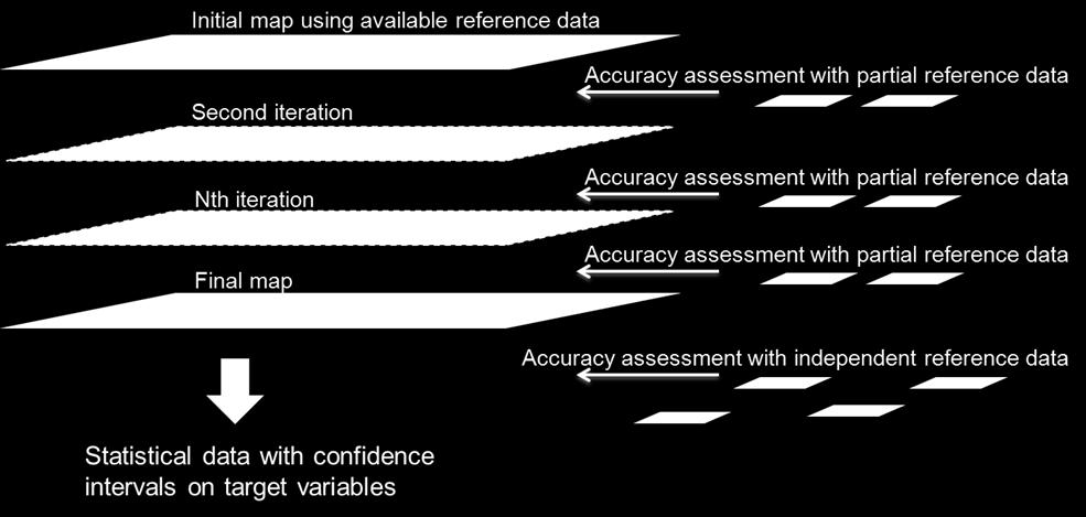
8 Iterative mapping process 8

9 Training and accuracy assessment C A B C A B Set A & B: training and reduction of bias Initial model with set A Acc. assessment with set A Optional model adjustment Acc. Assessment with set B Optional model adjustment Set C: Actual accuracy assessment No model adjustment Overall accuracy, user s and producer s accuracies C A B 9
10 Two-stage sampling First stage: sample of VHR images Second stage: Sample of plots within the VHR images Data for training and accuracy assessment Statistical information on variables of interest 14/06/2016 Häme et al IEEE JSTARS 10

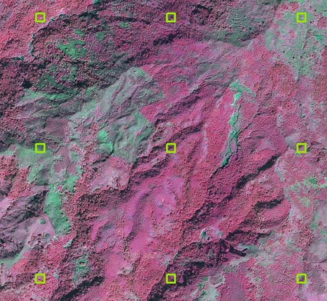
11 Sample plots of VHR data Visual interpretation of plots of 50 m x 50 m 29 11
12 A sample of class definitions applied in Chiapas Name in Class name ArcGIS Table Cultiv Cultivated and Managed Terrestrial Areas Description Areas where natural vegetation has been removed or modified and replaced by other types of vegetative cover of anthropogenic origin. All vegetation that is planted or cultivated with intent to harvest. Agricultural fields except paddy rice. Unit %. Nat_for Natural undisturbed forest Forest that is in natural condition and no clear signs of degradation are visible. Height more than 5 m, crown closure at least 10 %. (Usually in natural forest the height is much larger). Unit %. Nat_crown Crown closure of natural forest The projected area of tree crowns as the proportion of the total natural forest area. Unit %. Dstrb_for Disturbed forest Forest or woodland area which has re-grown after a major disturbance such as fire, insect infestation, timber harvest or windthrow, also natural forests that show clear signs of degradation due to selective cuttings, for instance. Height more than 5 m, crown closure at least 10 %. Unit %. Dstrb_crow n Crown closure of disturbed forest The projected area of tree crowns as the proportion of the total disturbed forest area. Unit %. 12

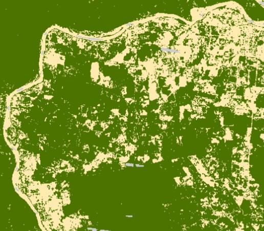
13 Image mosaic maps 13
14 Forest - non-forest maps from optical and PALSAR Landsat 1990 Landsat 1995 Landsat 2000 Landsat 2005 Landsat 2010 PALSAR2008 RapidEye 2011 RapidEye /06/


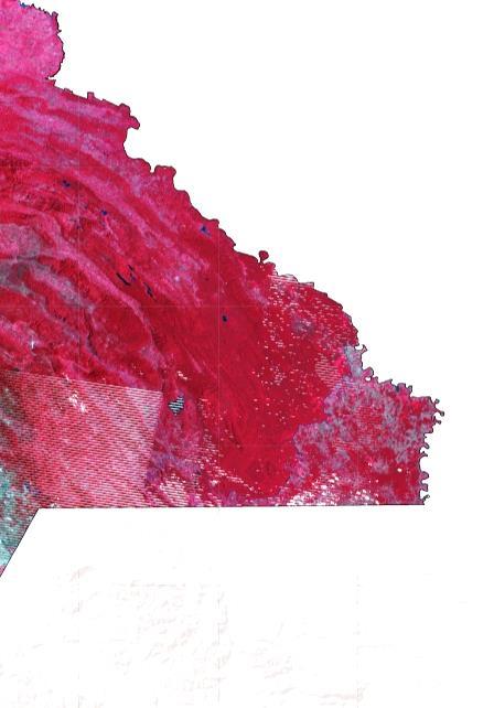
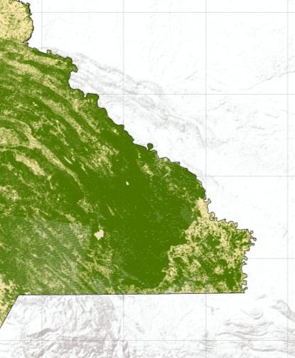
15 A map detail RapidEye Landsat TM ALOS PALSAR ENVISAT PALSAR ASAR + ASAR ALL Kompsat 2 KARI Sirro et al ESA Living Planet 2013 Häme et al ESA Living Planet 2013 Forest land Shrub Cropland Grassland Wetlands Settlements Other land No data Size of the area ~ 12 km x 8 km 14/06/

16 Cloudy optical maps augmented by SAR classifications 14/06/
17 Accuracy assessment results Chiapas sub-area Source data Overall accuracy (forest nonforest) Overall accuracy (six classes) Om. error for forest class Comm. error for forest class Num. obs. Proportion of the mapped area from the whole test area RapidEye 94 % 86 % 7 % 2 % %* Landsat 91 % 86 % 7 % 5 % % PALSAR 89 % 82 % 6 % 8 % % ASAR 76 % - 16% 17 % % PALSAR+ ASAR 89 % 81 % 7 % 8 % % Sirro et al ESA Living Planet 2013 * 17
18 Forest area estimate for state Chiapas, Mexico Forest area Missing data 50 % Landsat 1990 Landsat 1995 Landsat 2000 Landsat 2005 ALOS PALSAR 2008 Landsat 2010 RapidEye 2011 RapidEye


19 Landsat mosaic 1990 and GeoEye- 1 image from December 16 th /06/


20 Landsat mosaic 1990 and GeoEye-1 image from December 16 th /06/
21 Forest areas within VHR image areas in 2010 Chiapas, Mexico Landsat 2010 Forest, % Plot low 95% Plot high 95% Plot average % VHR Image (year 2010) Overall average Plots 69.2 % Landsat 65.5 % (sampling weighted to forested areas) 21
 and PALSAR (SAR) classifications to forest/non-forest and forest percentages from VHR plots (first value), AVNIR map (second value), and PALSAR map (third value) over a VHR image area.")
22 AVNIR (optical) vs. PALSAR accuracies Savannakhet, Laos Fig. 9. Overall accuracies of AVNIR (Opt.) and PALSAR (SAR) classifications to forest/non-forest and forest percentages from VHR plots (first value), AVNIR map (second value), and PALSAR map (third value) over a VHR image area. Dates of the acquisition of AVNIR data and image strip borders shown under the map. Häme et al JSTARS
23 Methods 1. Describe your current approach to forest stratification mapping and/or characterising the forest state b) Disturbance - degradation 14/06/


24 Service for Mexico: change between 1990 and Area size ~ 11 km x 13 km 14/06/
25 Landsat mosaics Landsat Landsat 2000 Red band Landsat 1995 Landsat 1990 change computation Forest nonforest map 2010 An algorithm to map degradation and recovery Change Change Change Change Forest nonforest map 2005 Forest nonforest map 2000 Forest nonforest map 1995 Forest nonforest map 1990 Forest in all years No No Nonforest in all years Yes Yes No All differen ces >0 and average > th1 All differenc es <0 and average < th2 Non-forest Variable Degradation Improvement Forest 14/06/ Yes No Yes No


26 Degradation & recovery Chiapas, Mexico 26


27 Changes in Chiapas Spot Spot Sentinel 2 Google Earth, Mateo E. J. Tinajero Google Earth, Yannick Meyer 14/06/


28 Structural parameter product examples Landsat TM/ETM 1990, 2010 Forest proportion difference / km Perforation density difference / km Forest patch number difference / km /06/

 PALSAR color composite image")
 PALSAR regression prediction with HV")
 PALSAR Probability prediction.")
29 Biomass predictions - Laos (a) (b) (a) (b) (c) (d) (c) (e) (f) Fig. 6. Biomass estimates with ALOS AVNIR and ALOS PALSAR data: (a) AVNIR color infrared composite image, (b) PALSAR color composite image (HH red, HV green, HH/HV blue), (c) AVNIR regression prediction with green band only, (d) PALSAR regression prediction with HV only, (e) Green + HV regression prediction, (f) AVNIR Probability prediction, (g) PALSAR Probability prediction. Area size 60 km by 40 km. ALOS data JAXA. (g) (d) Häme et al JSTARS 2013 (e) 29
30 PALSAR HH,HV for 2007 & 2010 Texture calculation Texture features from HV (2010/2007) ratio New road detection by linear feature extraction from HV (2010/2007) ratio New roads Clustering & labeling Algorithm for Mapping Selective Logging using SAR Marsh forest & non - forest exclusion Forest applicable to logging Preliminary logging map Applied in Rep. of Congo Selective logging map Rauste et al. ESA Living Planet
 Work done in project GSE (GMES Service Elements) Forest")
 Extension coordinated by GAF AG (Germany) and funded by ESA")
31 Selective Logging in Republic of Congo/PALSAR Derived Map Roads on HV ratio (left) and logged area (right) Work done in project GSE (GMES Service Elements) Forest Monitoring/REDD (Reducing of Emissions from Deforestation and forest Degradation in Developing Countries) Extension coordinated by GAF AG (Germany) and funded by ESA 14/06/

32 Accuracy Assessment of PALSAR-Derived Map 32


33 RADARSAT-2 data Disturbance by selective logging in from RADARSAT-2 time series original data take acquired on log-ratio image between and ; 14/06/

34 RADARSAT-2 mapping methodology Disturbance by selective logging in from RADARSAT-2 time series RADARSAT-2 acquisition timeline 14/06/

")
 375 m; (C) 525 m")
35 Texture extraction Disturbance by selective logging in from RADARSAT-2 time series (A) (B) (C) Window size: (A) 225 m; (B) 375 m; (C) 525 m 14/06/


36 Accuracy assessment Disturbance by selective logging in from RADARSAT-2 time series The overall accuracy was 96% in the area not affected by cutting, and 64 % in the area where selective logging was performed. Lansat 8 scene with ground reference plots 14/06/

37 Combining growth models and multi-date satellite imagery ESA Innovator project Accucarbon 14/06/

38 Combining growth models and multi-date satellite imagery ESA Innovator project Accucarbon where ρc is carbon density of the area unit ρs is carbon density at start of the period of examination ρe is equilibrium carbon density of the land use type in question f is a parameter on transition speed. Model by Larjavaara & Kanninen Univ. of Helsinki 14/06/
39 Methods 2. Describe your satellite data requirements optical Sentinel-2 ideal for wall to wall mapping of forest cover For the accuracy assessment of land cover variables onemeter or finer resolution required statistical sampling Acquisition frequency bi-annual in humid tropics because of rapid vegetative succession 14/06/
40 Details of Sentinel-2 and Landsat 8 images from August 20, 2015 from Southern Finland. Area size 2.5 km x 2.5 km 40
41 Methods 2. Describe your satellite data requirements radar Sentinel-1 or other C-band challenging can be used for stratification L-band good potential in land cover mapping with reservations 20 m multi-look resolution required With L-band potential for biomass similar to optical data with backscattering data Forest height with single pass interferometry - to be seen Use in particular when optical data are not available P-band SAR interesting but experimental with many restrictions (e.g. space object tracking radars, spatial resolution, ionosphere) 14/06/
42 Methods 3. What is your approach to calibration and validation of product Multisource data by combining sample and wall-to-wall as described above Independent data for the accuracy assessment 14/06/
43 Methods 4. Indicate the operational status of the existing technology (R&D, pre-operational, operational) Nothing really is operational? No market No standards for Variable definitions (degradation in particular) Products Methods optical pre-operational; radar R&D Accuracy assessment procedures No routine service provision and providers 14/06/
44 Technical challenges 1. Describe the obstacles to operational use Lack of market the main obstacle 2. Is ongoing access to data a concern? To a lesser extent L-band SAR; VHR optical budgetary restrictions 3. Are the methods limited by a lack of automation or simplicity? Yes more automation is needed but not at a price of quality Particularly in the radar domain methods for experts only 4. Are your IT/infrastructure needs met? Improving costs can be an issue ESA s Forestry Thematic Exploitation Platform tries to respond to the infrastructure challenge 14/06/


45 One-stop shop for forestry remote sensing services for the academic, operational public and commercial sectors Contact forestry-tep.eo.esa.int Tuomas Häme Renne Tergujeff In the photo, with permission: Daniel Vega / Universidad Juárez del Estado de Durango, a Forestry TEP pilot user
46 R&D requirements 1. Indicate the nature of the R&D required to advance the methods to operational use the whole monitoring concept should be developed with strong statistical justification radar methods unleashed to ordinary people automation standardization 2. What are the timelines for completing the R&D? never complete marked demand would (will?) enable operational services within 3 years 3. Describe your satellite data needs for R&D Most important data types already available- costs an issue Single pass L-band interferometric SAR would still be needed 14/06/
ESA UNCLASSIFIED - For Official Use
 ESA UNCLASSIFIED - For Official Use Forestry TEP Renne Tergujeff VTT Technical Research Centre of Finland Ltd ESA UNCLASSIFIED - For Official Use Objective of Forestry TEP (F-TEP) One-stop shop for forestry
ESA Thematic Exploitation Platforms and the Forestry Thematic Exploitation Platform (Forestry-TEP)
") ESA Thematic Exploitation Platforms and the Forestry Thematic Exploitation Platform (Forestry-TEP) Copernicus Training and Information Session November 22, 2016 Tuomas Häme, Renne Tergujeff VTT Technical
ESA Thematic Exploitation Platforms and the Forestry Thematic Exploitation Platform (Forestry-TEP) Copernicus Training and Information Session November 22, 2016 Tuomas Häme, Renne Tergujeff VTT Technical
LiDAR/SAR-based mapping of savannahs forests in Southern Africa
 Joint GFOI / GOFC-GOLD / CONABIO / SilvaCarbon R&D Expert and Capacity Building workshop on: Regional solutions to forest type stratification and characterising the forest state for national forest monitoring
Jo rg Haarpaintner Norut, N-9294 Tromsø, Norway
 Validation of SAR-based forest land cover and forest change maps and detectability of slash-and-burn activities in the Kwamouth region, Mai-Ndombe District, DRC. Jo rg Haarpaintner Norut, N-9294 Tromsø,
FOREST AND FOREST CHANGE MAPPING WITH C- AND L-BAND SAR IN LIWALE, TANZANIA
 FOREST AND FOREST CHANGE MAPPING WITH C- AND L-BAND SAR IN LIWALE, TANZANIA J. Haarpaintner a, C. Davids a, H. Hindberg a, E. Zahabu b, R.E. Malimbwi b a Norut, P.O. Box 6434, Tromsø Science Park, N-9294
The GMES Forest Monitoring REDD Services Preparation of Sentinel 2 Applications
 Sentinel-2 for Science Workshop 21 May 2014, Frasacti The GMES Forest Monitoring REDD Services Preparation of Sentinel 2 Applications T. Haeusler, S.Gomez, G.Ramminger, R. Siwe Consortium led by: Project
Product Delivery Report for K&C Phase 3. Francesco Holecz sarmap
 Product Delivery Report for K&C Phase 3 Francesco Holecz sarmap Science Team meeting #21 Phase 3 Result Presentations Kyoto Research Park, Kyoto, Japan, December 3-4, 2014 Project objectives The objective
Role and importance of Satellite data in the implementation of the COMIFAC Convergence Plan
 Plenary Meeting of the Congo Basin Forest Partnership (CBFP) Palais des Congrès, Yaoundé. Cameroon 11-12 November, 2009 Role and importance of Satellite data in the implementation of the COMIFAC Convergence
Forest Structural Classification and Above Ground Biomass Estimation for Australia
 Forest Structural Classification and Above Ground Biomass Estimation for Australia Professor Richard Lucas 1 Jingyi Sun 2 Centre for Ecosystem Sciences (CES) School of Biological, Earth and Environmental
MOSAICKING. Affiliation: European Commission DG Joint Research Centre. Method
 MOSAICKING Affiliation: European Commission DG Joint Research Centre Geocoding using: Method JAXA slant range 50 m HH+HV detected data + SCANSAR data SRTM, GTOPO elevation data JAXA orbital data Radiometric
GFOI Plenary/SDCG 11. GFOI R&D Groups. Martin Herold, Brice Mora (GOFC-GOLD) Anthea Mitchell (UNSW) Ake Rosenqvist (soloeo)
 Anthea Mitchell (UNSW) Ake Rosenqvist (soloeo)") GFOI Plenary/SDCG 11 GFOI R&D Groups Martin Herold, Brice Mora (GOFC-GOLD) Anthea Mitchell (UNSW) Ake Rosenqvist (soloeo) Defining research priorities & stimulating R&D Country needs and priorities UN-REDD,
GFOI Plenary/SDCG 11 GFOI R&D Groups Martin Herold, Brice Mora (GOFC-GOLD) Anthea Mitchell (UNSW) Ake Rosenqvist (soloeo) Defining research priorities & stimulating R&D Country needs and priorities UN-REDD,
F-TEP Forestry Thematic Exploitation Platform
 F-TEP Forestry Thematic Exploitation Platform Forest monitoring platforms workshop San Cristóbal de las Casas, Chiapas, Mexico 23 February 2016 Renne Tergujeff, Tuomas Häme VTT Technical Research of Finland
Forest Monitoring in Tropical Regions
 Forest Monitoring in Tropical Regions Manuela Hirschmugl & Mathias Schardt Institute of Digital Image Processing, Joanneum Research Content: 1. Background 2. Data 3. Methods 3.1. Pre-processing 3.2. Segmentation
Monitoring Forest Dynamics in Northeastern China in Support of GOFC
 Monitoring Forest Dynamics in Northeastern China in Support of GOFC Principal Investigator: Dr. Guoqing Sun, University of Maryland Co-Principal Investigator: Dr. Darrel L. Williams, NASA s Goddard Space
Product Delivery Report for K&C Phase 3. Christian Thiel et al. Friedrich-Schiller-University Jena, Germany
 Product Delivery Report for K&C Phase 3 Christian Thiel et al. Friedrich-Schiller-University Jena, Germany Science Team meeting #21 Phase 3 Result Presentations Kyoto Research Park, Kyoto, Japan, December
Activities of the GOFC-GOLD Land Cover Office and GFOI R&D Coordination Component
 Activities of the GOFC-GOLD Land Cover Office and GFOI R&D Coordination Component Brice Mora GOFC-GOLD LC / GFOI R&D Science Meeting, The Hague, The Netherlands 31 st Oct. 4 th November, 2016 GOFC-GOLD
RADAR for Biomass Mapping
 RADAR for Biomass Mapping Josef Kellndorfer Wayne Walker, Katie Kirsch, Greg Fiske The Woods Hole Research Center GOFC-GOLD Biomass Workshop Missoula, 15-June-2009 Outline Some Radar principles Measurements
Opportunities and challenges for monitoring tropical deforestation and forest degradation in dynamic landscapes using Sentinel-2!
 Sentinel-2 For Science Workshop 20-22 May, 2014 ESA-ESRIN Frascati Opportunities and challenges for monitoring tropical deforestation and forest degradation in dynamic landscapes using Sentinel-2 Dirk
Current Status of NFMIS in Myanmar & How MOLI data can Contribute to the ongoing Efforts. Myat Su Mon, Forest Department, Myanmar
 Current Status of NFMIS in Myanmar & How MOLI data can Contribute to the ongoing Efforts Myat Su Mon, Forest Department, Myanmar 26-05-2017 1 Presentation Outlines Background Information Challenges for
County- Scale Carbon Estimation in NASA s Carbon Monitoring System
 County- Scale Carbon Estimation in NASA s Carbon Monitoring System Ralph Dubayah, University of Maryland 1. Motivation There is an urgent need to develop carbon monitoring capabilities at fine scales and
Panel Discussion. Sergey Bartalev: Russia Tuomas Hame: Finland Eva Konkoly-Gyuro: Hungary Anu Reinart: Estonia Premysl Stych: Czech Republic
 Panel Discussion Sergey Bartalev: Russia Tuomas Hame: Finland Eva Konkoly-Gyuro: Hungary Anu Reinart: Estonia Premysl Stych: Czech Republic Panel Discussion Notes Russia Emphasis on Applications Forest/Agric/Wetland
ASSESSMENT AND MONITORING OF FOREST RESOURCES IN THE FRAMEWORK OF THE EU-RUSSIAN SPACE DIALOGUE THE ZAPÁS PROJECT
 Friedrich-Schiller-University Jena Institute for Geography Earth Observation ASSESSMENT AND MONITORING OF FOREST RESOURCES IN THE FRAMEWORK OF THE EU-RUSSIAN SPACE DIALOGUE THE ZAPÁS PROJECT 2011-14 C.C.
Malawi Multi-purpose use of ALOS PALSAR-1 data. sarmap and Forest Research Institute of Malawi (FRIM)
") Malawi Multi-purpose use of ALOS PALSAR-1 data sarmap and Forest Research Institute of Malawi (FRIM) Objective The objective is to demonstrate, at country-level, the multi-purpose use of ALOS PALSAR-1
Malawi Multi-purpose use of ALOS PALSAR-1 data sarmap and Forest Research Institute of Malawi (FRIM) Objective The objective is to demonstrate, at country-level, the multi-purpose use of ALOS PALSAR-1
Forest Dragon 3 Project Id
 Forest Dragon 3 Project Id. 10666 Principle Investigator: Co-Investigator: Young Scientists: Prof. Li, Academy of Forest Sciences Prof. Schmullius, University of Jena Prof. Pang, Dr. Feilong, Dr. Santoro
Satellite data applications in Indonesia
 Satellite data applications in Indonesia International Workshop on Inventory, Modeling, and Climate Impacts of GHG s and Aerosols in the Asian Region, Tsukuba, 26-28 June 2013 Outline National priorities
Potential of Sentinel 2 Constellation to Provide Near Real Rime Forest Disturbance Mapping Over Cloudy Areas in Gabon
 Potential of Sentinel 2 Constellation to Provide Near Real Rime Forest Disturbance Mapping Over Cloudy Areas in Gabon Dr Christophe Sannier Head of R&D christophe.sannier@sirs-fr.com Context Aim of project:
REDDAF. Infosheet. Content. Objective and Concept. November 2012
 November 2012 REDDAF Infosheet Content Objective and Concept Objective and Concept 1 User Requirements 2 Methods Development 2 Service Development 5 Validation and Proof of Concept 6 Capacity Building/Training
NCEO and Forest 2020 linkages to GFOI. Pedro Rodriguez Veiga Heiko Balzter Richard Tipper Ciaran Robb
 NCEO and Forest 2020 linkages to GFOI Pedro Rodriguez Veiga Heiko Balzter Richard Tipper Ciaran Robb GFOI SDCG meeting Ho Chi Minh City (Vietnam) April 2017 The University of Leicester is leading the UK
K&C Phase 4 Status report
 K&C Phase 4 Status report Measuring above ground biomass and changes over Brazilian tropical secondary forests and savanna woodlands (Cerrado) using L-band SAR data Shaun Quegan, João Carreiras National
UK NCEO work on Global Forest. SDCG-10: Reading, 7-9 September, 2016
 UK NCEO work on Global Forest SDCG-: Reading, 7- September, 26 Examples from NCEO-University of Leicester Pedro Rodriguez-Veiga, Heiko Balzter, Kevin Tansey, Ciaran Robb, Ana Maria Pacheco, Ramesh Ningthoujam
Generating Data from National Forest Monitoring
 Generating Data from National Forest Monitoring and Click Carbon to edit Accounting (REDD Master MRV) title style Alexander Lotsch Click to edit Master subtitle style World Bank Forest Carbon Partnership
Satellites and the implementation of REDD+: a case study from Indonesia
 Satellites and the implementation of REDD+: a case study from Indonesia Ed Mitchard (University of Edinburgh) Mandar Trivedi (ZSL) Murray Collins (University of Edinburgh) What is REDD+? Reducing Emissions
K&C Phase 4 Brief project essentials
 K&C Phase 4 Brief project essentials Measuring above-ground biomass and its changes over Brazilian tropical secondary forests and savanna woodlands (Cerrado) using L-band SAR data Shaun Quegan, João Carreiras
K&C Phase 4 Status report. Utilising L-Band SAR Data for Natural Resource Management in the Philippines
 K&C Phase 4 Status report Utilising L-Band SAR Data for Natural Resource Management in the Philippines Mari Trix Estomata 1, Jose Don De Alban 2, Angelica Kristina Monzon 2, Patricia Sanchez 3, and Enrico
RESULTS & RECOMMENDATIONS from. The Dragon Forest Projects
 RESULTS & RECOMMENDATIONS from The Dragon Forest Projects Forest Fire Id. 10350 Forest Change Monitoring Id. 10549 PolInSAR Id. 10609 The Forest Dragon 3 Id. 10666 Forest Resources Research Id. 10667 Forest
JAXA s MRV - current status and future envision -
 JAXA s MRV - current status and future envision - Masanobu Shimada Japan Aerospace Exploration Agency Earth Observation Research Center MRV symposium at Tokyo Forum Feb. 17, 2011 Concept Satellite data
MONITORING LAND USE AND LAND USE CHANGES IN FRENCH GUIANA BY OPTICAL REMOTE SENSING
 MONITORING LAND USE AND LAND USE CHANGES IN FRENCH GUIANA BY OPTICAL REMOTE SENSING Photo : Valéry Gond Photo : Valéry Gond Photo Photo : Gaëlle : : Valéry VERGER Gond Gaëlle VERGER ONF, French National
Earth Observation for Sustainable Development of Forests (EOSD) - A National Project
 - A National Project") Earth Observation for Sustainable Development of Forests (EOSD) - A National Project D. G. Goodenough 1,5, A. S. Bhogal 1, A. Dyk 1, R. Fournier 2, R. J. Hall 3, J. Iisaka 1, D. Leckie 1, J. E. Luther
Earth Observation for Sustainable Development of Forests (EOSD) - A National Project D. G. Goodenough 1,5, A. S. Bhogal 1, A. Dyk 1, R. Fournier 2, R. J. Hall 3, J. Iisaka 1, D. Leckie 1, J. E. Luther
Assessing Forest Degradation using Time Series of Fine Spatial Resolution Imagery in Africa
 Assessing Forest Degradation using Time Series of Fine Spatial Resolution Imagery in Africa A. Verhegghen, B. Desclée, H. Eva, P. Mayaux, F. Achard European Commission Joint Research Centre Sentinel-2
K&C Phase 4 Status report. Retrieval of forest biomass and biomass change with spaceborne SAR
 K&C Phase 4 Status report Retrieval of forest biomass and biomass change with spaceborne SAR Johan Fransson 1, Jonas Fridman 1, Ivan Huuva, Håkan Olsson 1, Henrik J. Persson 1, Jörgen Wallerman 1, Maurizio
National Forest Monitoring System Development in Cambodia
 National Forest Monitoring System Development in Cambodia 5 th UN-REDD Regional Lesson Learn Workshop Forest Monitoring System and Reference Levels for REDD+ Hanoi, Vietnam, 20-22 October, 2014 Presented
Remote sensing as a tool to detect and quantify vegetation properties in tropical forest-savanna transitions Edward Mitchard (University of Edinburgh)
") Remote sensing as a tool to detect and quantify vegetation properties in tropical forest-savanna transitions Edward Mitchard (University of Edinburgh) Presentation to Geography EUBAP 10 th Oct 2008 Supervisor:
Remote sensing as a tool to detect and quantify vegetation properties in tropical forest-savanna transitions Edward Mitchard (University of Edinburgh) Presentation to Geography EUBAP 10 th Oct 2008 Supervisor:
Monitoring carbon emissions from forest degradation for REDD
 Global Observation of Forest and Land Cover Dynamics Monitoring carbon emissions from forest degradation for REDD Martin Herold GOFC-GOLD Land Cover Office, FSU Jena, Germany www.gofc-gold.uni-jena.de
Rice crop monitoring using EO data in the Mekong Delta, Vietnam
 The 10th GEOSS Asia-Pacific Symposium WG5: Agriculture and Food Security Hanoi, 18-20 th, Sep. 2017 Rice crop monitoring using EO data in the Mekong Delta, Vietnam Lam Dao Nguyen, Hoang Phi Phung, Dang
Problem. Land should be paid in order to reduce deforestation. Particularly challenging to turn data into useful information / country statistics
 FAO / Norway SEPAL April 2016 Problem Deforestation in the tropics constitutes of 15-20% of global greenhouse gas emissions (GHG) Reduction of GHG needed to achieve the two-degree target Norway advocates
Monitoring forest & tree cover in Africa with Japanese satellite. JAXA Presented by Manabu Watanabe (Tokyo Denki University)
") Monitoring forest & tree cover in Africa with Japanese satellite. JAXA Presented by Manabu Watanabe (Tokyo Denki University) Contents 1. Japanese satellites 2. Forest/Non-Forest Map 3. JICA-JAXA Forest
Monitoring forest & tree cover in Africa with Japanese satellite. JAXA Presented by Manabu Watanabe (Tokyo Denki University) Contents 1. Japanese satellites 2. Forest/Non-Forest Map 3. JICA-JAXA Forest
K&C Phase 4 Brief project essentials. Asia-RiCE: Rice Crop Estimation and Monitoring. Shin-ichi Sobue Remote Sensing Technology Center of Japan
 K&C Phase 4 Brief project essentials Asia-RiCE: Rice Crop Estimation and Monitoring Shin-ichi Sobue Remote Sensing Technology Center of Japan Science Team meeting #21 Phase 4 Kick-off Kyoto Research Park,
Research and Training on Big Data
 Research and Training on Big Data Seminar on Statistical Capacity Building for New Data Sources Keio Plaza Hotel, Tokyo, Japan 8 December 2017 Kaushal Joshi Asian Development Bank Outline Conventional
Quantifying forest degradation and associated drivers in the Congo Basin Aurélie C. Shapiro World Wide Fund for Nature (WWF)
") Quantifying forest degradation and associated drivers in the Congo Basin Aurélie C. Shapiro World Wide Fund for Nature (WWF) Science Team meeting #16 Phase 3 Kick off JAXA TKSC/RESTEC HQ, Tsukuba/Tokyo,
Quantifying forest degradation and associated drivers in the Congo Basin Aurélie C. Shapiro World Wide Fund for Nature (WWF) Science Team meeting #16 Phase 3 Kick off JAXA TKSC/RESTEC HQ, Tsukuba/Tokyo,
The Australian DataCube and Carbon Accounting
 The Australian DataCube and Carbon Accounting Alex Held November 2, 2015 LAND AND WATER The Australian National Carbon Accounting System uses Satellite Data to Detect Land Clearing and Regrowth As part
Global Forest Observations Initiative
 Global Forest Observations Initiative Frank Martin Seifert (ESA / Co Chair SDCG), 12 November 2016 / Forest Governance Initiative JICA/JAXA / COP 22 Marrakesh What is GFOI? Through collaborative action,
PALSAR TROPICAL FOREST COVER MAPPING, MOSAICING AND VALIDATION, CASE STUDY BORNEO
 PALSAR TROPICAL FOREST COVER MAPPING, MOSAICING AND VALIDATION, CASE STUDY BORNEO Dirk H. Hoekman 1), M.J. Quiñones 2), R. Verhoeven 2), M.A.M. Vissers 2), V. Schut 2) and N. Wielaard 2) 1) Wageningen
Tiger project #2 : Biomass evaluation of tropical dry and wet forests. Climate change impacts
 Tiger II Workshop Hartebeeshoek, South Africa, 12 13 December 2011 Tiger project #2 : Biomass evaluation of tropical dry and wet forests. Climate change impacts Laboratory Institution Partners Project
Using global datasets for biomass and forest area estimation: Miombo forests in Tanzania
 Using global datasets for biomass and forest area estimation: Miombo forests in Tanzania Erik Næsset, Terje Gobakken, Hans Ole Ørka (NMBU, Norway) 2111 2005 Objectives Quantify and compare precision of
Forest Applications. Chris Schmullius, Oliver Cartus, Maurizio Santoro. 5 September 2007, D3PB
 Forest Applications Chris Schmullius, Oliver Cartus, Maurizio Santoro 5 September 2007, D3PB 4 September 2007 D3PB-2 Forest practicals Christiane Schmullius 2 Einführung mit C/X-Äthna-Beispielen MFFU Sommerschule
K&C Phase 3 Brief project essentials. Climate-Relevant Modernization of the National Forest Policy and Piloting of REDD+ Measures in the Philippines
 K&C Phase 3 Brief project essentials Climate-Relevant Modernization of the National Forest Policy and Piloting of REDD+ Measures in the Philippines Francisco B. Tavora, Jr. 1, Jose Don T. De Alban 2, Enrico
FOREST BIOMASS & CARBON STOCKS MAPPING USING SATELLITE IMAGERIES & ISSUES RELATING TO REDD+ IN MALAYSIA
 FOREST BIOMASS & CARBON STOCKS MAPPING USING SATELLITE IMAGERIES & ISSUES RELATING TO REDD+ IN MALAYSIA Hamdan Omar GeoInformation Programme Division of Forestry and Environment, FRIM Workshop on Methods
K&C Phase 4 Status report. Retrieval of forest biomass and biomass change with spaceborne SAR
 K&C Phase 4 Status report Retrieval of forest biomass and biomass change with spaceborne SAR Johan Fransson 1, Jonas Fridman 1, Ivan Huuva 1 Håkan Olsson 1, Henrik Persson 1, Jörgen Wallerman 1, Maurizio
Forest Changes and Biomass Estimation
 Forest Changes and Biomass Estimation Project Title: Comparative Studies on Carbon Dynamics in Disturbed Forest Ecosystems: Eastern Russia and Northeastern China Supported by NASA Carbon Cycle Science
The BIOMASS Mission. Klaus Scipal 24/01/2019. ESA UNCLASSIFIED - For Official Use
 The BIOMASS Mission Klaus Scipal 24/01/2019 ESA UNCLASSIFIED - For Official Use The BIOMASS Mission 1. ESA s 7 th Earth Explorer Mission 2. An interferometric, polarimetric P-band SAR 3. To be deployed
Mapping Coastal Great Lakes Wetlands and Adjacent Land use Through Hybrid Optical-Infrared and Radar Image Classification Techniques
 Mapping Coastal Great Lakes Wetlands and Adjacent Land use Through Hybrid Optical-Infrared and Radar Image Classification Techniques Laura L. Bourgeau-Chavez, Kirk Scarbrough, Mary Ellen Miller, Zach Laubach,
Understanding Juniper Forest Encroachment into Grasslands in Oklahoma and the Impacts on Primary Production, Evapotranspiration, and Climate
 Understanding Juniper Forest Encroachment into Grasslands in Oklahoma and the Impacts on Primary Production, Evapotranspiration, and Climate Jie Wang 04/24/2018 Earth observation and modeling Department
ALOS K&C Project updated
 ALOS K&C Project updated Thuy Le Toan CESBIO, France 1. Forest products: forest and biomass maps 2. Wetlands products: rice maps inundation maps Forest and forest biomass maps K&C product(s): Algorithms
Background. Chapter (DeFries et al.) in IPAM/ED book (eds: Moutinho + Schwartzman)
 in IPAM/ED book (eds: Moutinho + Schwartzman)") Global Observation of Forest and Land Cover Dynamics Monitoring Deforestation for Compensated Reductions Martin Herold ESA GOFC-GOLD Land Cover Project Office FSU Jena, Germany on behalf of GTOS/GOFC-GOLD
Global Observation of Forest and Land Cover Dynamics Monitoring Deforestation for Compensated Reductions Martin Herold ESA GOFC-GOLD Land Cover Project Office FSU Jena, Germany on behalf of GTOS/GOFC-GOLD
The NISAR Mission. Paul Siqueira Emerging Technologies and Methods in Earth Observation for Agriculture Monitoring College Park, 2018
 The NISAR Mission Paul Siqueira Emerging Technologies and Methods in Earth Observation for Agriculture Monitoring College Park, 2018 Flyer A one-page paper-flyer is available with more information NISAR
Module 2.1 Monitoring activity data for forests using remote sensing
 Module 2.1 Monitoring activity data for forests using remote sensing Module developers: Frédéric Achard, European Commission (EC) Joint Research Centre (JRC) Jukka Miettinen, EC JRC Brice Mora, Wageningen
Remote Sensing as a Tool for a Survey of Defoliation and Yield Losses
 FoRisk Network, October 26-28, 2009, Tvärminne, Finland Remote Sensing as a Tool for a Survey of Defoliation and Yield Losses Docent Päivi Lyytikäinen-Saarenmaa, Department of Forest Ecology, University
K&C Phase 3 Brief project essentials. Wide area forest monitoring of Insular SE Asia and Guiana Shield. Dirk Hoekman Wageningen University
 K&C Phase 3 Brief project essentials Wide area forest monitoring of Insular SE Asia and Guiana Shield Dirk Hoekman Wageningen University Science Team meeting #16 Phase 3 Kick-off JAXA TKSC/RESTEC HQ, Tsukuba/Tokyo,
Forest Biomass Estimation, Australia
 Forest Biomass Estimation, Australia 1 Richard Lucas, 2 John Armston, 1 Peter Bunting, 1 Daniel Clewley, 2 Peter Scarth, 2 Michael Schmidt, 2 Arnon Accad, 3 Paul Siqueira and 3 Yang Lei 1 Institute of
FPCD-IGES Community-based Forest Monitoring Project
 FPCD-IGES Community-based Forest Monitoring Project Prepared by Henry Scheyvens, Inputs from Yati A. Bun, Lavinia Poruschi, Makino Yamanoshita and Mark Winai Workshop on Challenges and Opportunities for
REDD+ for the Guiana Shield. Terms of Reference SAR Technical Training for Forest Mapping
 REDD+ for the Guiana Shield Technical and Regional Platform for the Development of REDD+ in the Guiana Shield Terms of Reference SAR Technical Training for Forest Mapping Project Owner: Office National
Reducing Emissions from Deforestation and Degradation in Africa (REDDAF)
") Reducing Emissions from Deforestation and Degradation in Africa (REDDAF) Thomas Haeusler/GAF AG, Sharon Gomez/GAF AG, René Siwe/GAF AG, Thuy Le Toan/CESBIO, Stephane Mermoz/CESBIO, Mathias Schardt/JR,
Reducing Emissions from Deforestation and Degradation in Africa (REDDAF) Thomas Haeusler/GAF AG, Sharon Gomez/GAF AG, René Siwe/GAF AG, Thuy Le Toan/CESBIO, Stephane Mermoz/CESBIO, Mathias Schardt/JR,
William Salas Applied GeoSolutions (AGS) Durham, NH USA,
 Durham, NH USA,") K&C Phase 3 Brief project essentials Application of PALSAR for regional assessments of forest disturbance, rice agriculture and wetland habitats. William Salas Applied GeoSolutions (AGS) Durham, NH USA,
K&C Phase 3 Brief project essentials Application of PALSAR for regional assessments of forest disturbance, rice agriculture and wetland habitats. William Salas Applied GeoSolutions (AGS) Durham, NH USA,
Linking Remote Sensing and In situ data for global policies applications. NFM, REDD+ Team FAO
 Linking Remote Sensing and In situ data for global policies applications NFM, REDD+ Team FAO Inge JONCKHEERE RS & EO Lead REDD+ Team, FAO Forestry Dept. CCI Biomass User Workshop Paris (FR), September
K&C Phase 3 Brief project essentials. Mangrove extent, change and structure in Africa and the Americas
 K&C Phase 3 Brief project essentials Mangrove extent, change and structure in Africa and the Americas Lola Fatoyinbo NASA Goddard Space Flight Center Marc Simard Caltech Jet Propulsion Laboratory Science
Using multi-temporal ALOS PALSAR to investigate flood dynamics in semi-arid wetlands: Murray Darling Basin, Australia.
 Using multi-temporal ALOS PALSAR to investigate flood dynamics in semi-arid wetlands: Murray Darling Basin, Australia. Rachel Melrose, Anthony Milne Horizon Geoscience Consulting and University of New
K&C Phase 4 Status report
 K&C Phase 4 Status report Measuring above ground biomass and changes over Brazilian tropical secondary forests and savanna woodlands (Cerrado) using L-band SAR data Shaun Quegan, João Carreiras National
the wheat fields is small, and as for fields of puddling and leveling in winter and other fields in similar, the difference is small. It is conclude t
 OBSERVATION OF JAPANESE PADDY RICE FIELDS USING MULTI TEMPORAL AND POLARIMETRIC PALSAR DATA PI No.365 Naoki ISHITSUKA 1, Genya SAITO 2, Fan YANG 3, Chinatsu YONEZAWA 4 and Shigeo OGAWA 5 1 National Institute
MRV requirements from an implementation perspective. Inge Jonckheere FAO Forestry, UN-REDD. 21 September 2015 Bonn, Germany
 MRV requirements from an implementation perspective Inge Jonckheere FAO Forestry, UN-REDD 21 September 2015 Bonn, Germany FAO and its role in REDD+ z FAO s key role in REDD+ readiness is to help countries
Monitoring historical forest degradation (with focus on changes in carbon stocks on national level)
") Global Observation of Forest and Land Cover Dynamics Monitoring historical forest degradation (with focus on changes in carbon stocks on national level) Martin Herold GOFC-GOLD Land Cover Office, FSU Jena,
Global Observation of Forest and Land Cover Dynamics Monitoring historical forest degradation (with focus on changes in carbon stocks on national level) Martin Herold GOFC-GOLD Land Cover Office, FSU Jena,
Forest Disturbances Requirements of Biomass Datasets
 CENTRE FOR LANDSCAPE AND CLIMATE RESEARCH Forest Disturbances Requirements of Biomass Datasets Heiko Balzter Pedro Rodriguez-Veiga 1 st ESA CCI Biomass Workshop, Paris, France 25-26 September 2018 Biomass
Progress Report for COMBINED SATELLITE MAPPING OF SIBERIAN LANDSCAPES: NATURAL AND ANTHROPOGENIC FACTORS AFFECTING CARBON BALANCE
 Progress Report for COMBINED SATELLITE MAPPING OF SIBERIAN LANDSCAPES: NATURAL AND ANTHROPOGENIC FACTORS AFFECTING CARBON BALANCE Submitted to : Dr. Garik Gutman, LCLUC Program Manger Dr. Waleed Ablati,
Space Technology for Monitoring & Managing Forest in Nigeria
 Space Technology for Monitoring & Managing Forest in Nigeria Professor Ayobami T. Salami Project Coordinator, Geo-information System-Based Forest Monitoring in Nigeria (GEOFORMIN) & Dr. Joseph Akinyede
xvii Conservation Division 1, Forestry and Nature Conservation Group, Global Environment Department (R/D):
:") Summary of Terminal Evaluation I. Outline of the Project Country: Indonesia Project title:the Project for the Support on Forest Resources Management through Leveraging Satellite Image Information Issue/Sector:
Summary of Terminal Evaluation I. Outline of the Project Country: Indonesia Project title:the Project for the Support on Forest Resources Management through Leveraging Satellite Image Information Issue/Sector:
Joint Experiment for Crop Assessment and Monitoring GEOGLAM Implementation Meeting Washington D.C. February 21, 2013
 Joint Experiment for Crop Assessment and Monitoring GEOGLAM Implementation Meeting Washington D.C. February 21, 2013 Ian Jarvis JECAM Sub-Task Lead Earth Observation Service, Agriculture and Agri-Food
Product Delivery Report for K&C Phase 3. Nathan Torbick, William Salas Applied Geosolutions. Collaborators: J. Dong, M. Ducey, C. Li, J. Qi, X.
 Product Delivery Report for K&C Phase 3 Nathan Torbick, William Salas Applied Geosolutions Collaborators: J. Dong, M. Ducey, C. Li, J. Qi, X. Xiao Science Team meeting #21 Phase 3 Result Presentations
PAN-TROPICAL ALOS/PALSAR MAPPING IN SUPPORT OF FOREST CARBON TRACKING
 PAN-TROPICAL ALOS/PALSAR MAPPING IN SUPPORT OF FOREST CARBON TRACKING Josef Kellndorfer 1, Wayne Walker 1, Jesse Bishop 1, Tina Cormier 1, Katie Kirsch 1, Greg Fiske 1, Francesco Holecz 2, Alessandro Baccini
SATELLITE BASED MONITORING OF FOREST RESOURCES COMPLIANT WITH REDD+ AND ZERO DEFORESTATION
 SATELLITE BASED MONITORING OF FOREST RESOURCES COMPLIANT WITH REDD+ AND ZERO DEFORESTATION THOMAS HAEUSLER, FABIAN ENßLE, SHARON GOMEZ GAF AG, Germany forestry@gaf.de Paper prepared for presentation at
IIASA experience in analyzing global forest datasets
 IIASA experience in analyzing global forest datasets Dmitry Schepaschenko, Myroslava Lesiv, Aline Moisnier, Steffen Fritz Marie Curie FP7-MC-IIF: SIFCAS Independent monitoring GHG emission Modeling Biomass
ANALYSIS OF ALOS/PALSAR POLARIMETRIC SIGNATURES AND SCATTERING MECHANISMS OF FOREST TYPES IN TAPAJÓS S REGION, BRAZIL
 ANALYSIS OF ALOS/PALSAR POLARIMETRIC SIGNATURES AND SCATTERING MECHANISMS OF FOREST TYPES IN TAPAJÓS S REGION, BRAZIL J. R. dos Santos 1 ; I. S. Narvaes 1.; P. M. L. A. Graça 2 ; F. G. Gonçalves 3 (1)
A global perspective on land use and cover change
 A global perspective on land use and cover change Alan Belward The Global Environment Monitoring Unit Institute for Environment and Sustainability European Commission Joint Research Centre 21027 Ispra
Workshop FOR-X R&D Project by Remote Sensing Solutions GmbH and Infoterra GmbH
 Workshop FOR-X R&D Project by Remote Sensing Solutions GmbH and Infoterra GmbH Hosted by: National Standardization Agency of Indonesia (BSN) Organized by: Center for International Forestry Research (CIFOR)
K&C Phase 4 Status report. Coupling radar-based estimates of forest information with biosphere models for improved carbon flux estimation
 K&C Phase 4 Status report Coupling radar-based estimates of forest information with biosphere models for improved carbon flux estimation Maurizio Santoro & Oliver Cartus GAMMA Remote Sensing Nuno Carvalhais
Rice crop monitoring in Vietnam using radar remote sensing data
 Earth Observation Technologies for Crop Monitoring: A Workshop to Promote Collaborations among GEOGLAM/JECAM/Asia-RiCE 2018 17-20 September 2018 Taichung, Taiwan Rice crop monitoring in Vietnam using radar
Guiana Shield Activities Radar Point of view
 Guiana Shield Activities Radar Point of view SAR Technical Workshop for Forest Mapping Session 2 Applications - April 2015 Cédric Lardeux Jean-Paul Rudant Pierre-Louis Frison cedric.lardeux@onfinternational.com
K&C Initiative, Extension Phase : Mapping and monitoring of forests in Sweden using ALOS PALSAR data
 K&C Initiative, Extension Phase 2009-2011: Mapping and monitoring of forests in Sweden using ALOS PALSAR data Johan Fransson and Håkan Olsson Swedish University of Agricultural Sciences, Sweden Leif Eriksson
Forestry and Agricultural Greenhouse Gas Modeling Forum # Shepherdstown, WV
 Forestry and Agricultural Greenhouse Gas Modeling Forum #4 March 6-8, 6 2007 Shepherdstown, WV Overview of scientific, technical and methodological issues related to reducing emissions from deforestation
REDD-COMIFAC Meeting March 2008, Paris. REDD Pilot Project COMIFAC: Cameroon. T. Haeusler, S. Gomez
 REDD-COMIFAC Meeting 10-12 March 2008, Paris R e d u c i n g E m i s s i o n s f r o m D e f o r e s t a t i o n a n d D e g r a d a t i o n REDD Pilot Project COMIFAC: Cameroon T. Haeusler, S. Gomez Consortium
Impact of oil palm plantations on peatland conversion in Sarawak
 Impact of oil palm plantations on peatland conversion in Sarawak 2005-2010 January 2011 Commissioned by Wetlands International Cover image credit: ALOS satellite (left) EORC/JAXA, Aerial photo (right)
Integration of Alos PalSAR and LIDAR IceSAT data in a multistep approach for wide area biomass mapping
 Integration of Alos PalSAR and LIDAR IceSAT data in a multistep approach for wide area biomass mapping. Above Ground Biomass (carbon) mapping and monitoring: Importance Supporting UNFCC KP, REDD+, Monitoring