Fire Episodes in the Inland Northwest ( ) Based on Fire History Data
|
|
|
- Howard O’Brien’
- 5 years ago
- Views:
Transcription


 Based on")

1 United States Department of Agriculture Forest Service Intermountain Research Station General Technical Report INT-GTR-370 October 1997 Fire Episodes in the Inland Northwest ( ) Based on Fire History Data Stephen W. Barrett Stephen F. Arno James P. Menakis circa 1889 episode Fire occurrence
2 The Authors Stephen W. Barrett is a Consulting Research Forester in Kalispell, MT. He earned a B.S. degree in park administration at the University of Massachusetts and an M.S. degree in forestry at the University of Montana. Since 1979 he has studied fire history in many areas of the Inland West for the USDA Forest Service, USDI National Park Service, and other wildland management agencies. Stephen F. Arno is a Research Forester in the Fire Effects Research Work Unit at the Intermountain Fire Sciences Laboratory in Missoula, MT. He received a B.S. degree in forestry from Washington State University and Master of Forestry and a Ph.D. degree from the University of Montana. He has studied various aspects of forest ecology since 1963, including ecological site classifications, forest succession, fire history, fire effects, and the development of strategies for prescribed fire. James P. Menakis is a Forester in the Fire Effects Research Work Unit at the Intermountain Fire Sciences Laboratory in Missoula, MT. He received both his B.S. degree in forestry and M.S. degree in environmental studies from the University of Montana. For the past 7 years he has worked on projects relating to fire ecology on a community and landscape level. He is currently involved in change detection and mapping of ecological attributes and vegetation classification using image processing and GIS. He has been GIS coordinator for the Landscape Ecology Team of the Columbia River Basin Assessment Project. He also was involved with evaluating the prescribed natural fire program in the Selway-Bitterroot Wilderness (Brown and others 1994). Research Summary Information from fire history studies in the Northwestern United States was used to identify and map fire episodes (5 year periods) when fire records were most abundant. Episodes of widespread landscape-scale fires occurred at average intervals of 12 years. Mean annual acreage burned was calculated based on estimated areas of historical vegetation types with their associated fire intervals from the fire history studies. An average of about 6 million acres of forest and grass and shrubland burned annually within the 200 million acre Columbia River Basin study region, and especially active fire years probably burned twice this much area. For comparison, the largest known fire years since 1900 have each burned 2 million to 3 million acres in this region. We also compare the occurrence of regional fire episodes to drought cycles defined by tree-ring studies. Acknowledgments This presentation was difficult to develop because the data came from diverse sources with considerable variation in methods and reporting. Several people gave valuable advice and encouragement to help develop a more useful product: James K. Brown (retired), Elizabeth Reinhardt, and Mark Finney of the Intermountain Fire Sciences Laboratory in Missoula, MT; David A. Thomas of the USDA Forest Service, Intermountain Region; Richard Lasko of the USDA Forest Service, Northern Region; and Thomas Swetnam of the Laboratory of Tree Ring Research at the University of Arizona, Tucson. Helen Y. Smith and Michael A. Krebs provided valuable assistance in developing the manuscript for publication. You may order additional copies of this publication by sending your mailing information in label form through one of the following media. Please specify the publication title and General Technical Report number. Telephone (801) DG message Pubs:S22A FAX (801) , Attn: Publications /s=pubs/ou1=s22a@mhs-fswa.attmail.com Mailing Address Publications Ogden Service Center Rocky Mountain Research Station (formerly Intermountain Research Station) th Street Ogden, UT Rocky Mountain Research Station (formerly Intermountain Research Station) th Street Ogden, UT 84401
3 Fire Episodes in the Inland Northwest ( ) Based on Fire History Data Stephen W. Barrett Stephen F. Arno James P. Menakis Introduction One goal of the Interior Columbia Basin Ecosystem Management Project (ICBEMP) is to develop information to aid broad-scale management of Federal lands for a large area of the Northwestern United States (Haynes and others 1996). Information on the historic scale of fire in the ICBEMP study region (fig. 1) is useful as an ecological benchmark because fire has been important in shaping vegetation structure and composition in this region for thousands of years (Johnson and others 1994). Detailed maps and records of fires extend back only a few decades and are not available for the historic fire period, before fire suppression and land use changes influenced the role of fire (Agee 1993). However, long-term records of fire history are available from many individual sites based on studies of fire scars on old trees and stumps and ages of trees that became established after past fires (Barrett and Arno 1988). In conjunction with the ICBEMP, Barrett (1995a) compiled information from fire history studies within the ICBEMP study region, allowing us to review the role of historical fires on a regional scale by mapping locations where past fires were detected. We recorded the fire locations on a regional map, and we report the periods (termed fire episodes) when these fire records were most abundant between 1540 and By 1940, fire suppression was effective in limiting the role of natural fire throughout the region (Pyne 1982). Maps of the fire episodes represent 5 year periods having abundant and widespread fire evidence, from fire scars on trees and age-classes of trees that regenerated after fires (Agee 1993; Barrett and Arno 1988). While data do not provide measurements on the extent and pattern of individual fires, collectively they offer evidence of historical fires on a broad landscape scale evidence previously unavailable. We also examine the relationship of fire episodes to regional drought as identified by dendrochronological (tree ring) records (Stokes and Smiley 1968). To estimate the extent of historical burning in the ICBEMP study region, we calculated mean annual acreages burned based on estimated acreages of historical vegetation types (Losensky 1995) and their associated mean fire intervals average number of years between fires on any site within the vegetation type. We compare these estimates of historical burning with areas burned in recent decades. This information on the historical role of fire should be useful for understanding fire as a landscape-scale process. Methods Three aspects of fire history were investigated: (1) identifying and mapping regional fire episodes, (2) inspecting relationships of regional drought to fire episodes, and (3) estimating mean annual area burned throughout the ICBEMP region. First, a literature search was conducted to obtain all published fire history studies in the ICBEMP region. Ecologists in the region were contacted for copies of unpublished fire history data. Master fire chronologies (Romme 1980) and associated latitudinal and longitudinal coordinates (to the nearest minute) were obtained for each study area, that ranged in size from a single point, such as a fire-scarred tree, to an entire watershed experiencing stand-replacement burning. Fire history studies provided most of the information, but data on fires greater than 10 acres in size were obtained from fire atlases maintained by land management agencies, early newspapers, and other historic records. In each case one fire record was entered in the database for each fire year in each fire chronology. The database was summarized in three ways. Most fire history studies were based on tree ring counts to estimate years of fire scars without dendrochronological cross-dating to enhance dating precision (Madany and others 1983). As a result, many fire year estimates for pre-1900 fires are probably within plus or minus 2 years of the actual date (Arno and Sneck 1977; Arno and others 1995; Fiedler and Steele 1992). Consequently, rather than individual years, we analyzed fire episodes, which we define as 5 year periods with abundant evidence of fire in the ICBEMP study region. To identify fire episodes, a running 5 year tally 1
4 Figure 1 Outline of the Interior Columbia Basin Ecosystem Management Project (ICBEMP) study region (Scientific Assessment area). 2
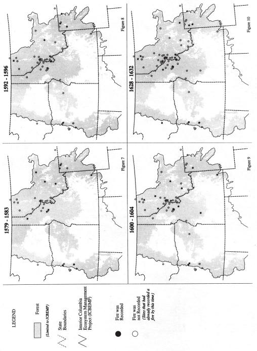
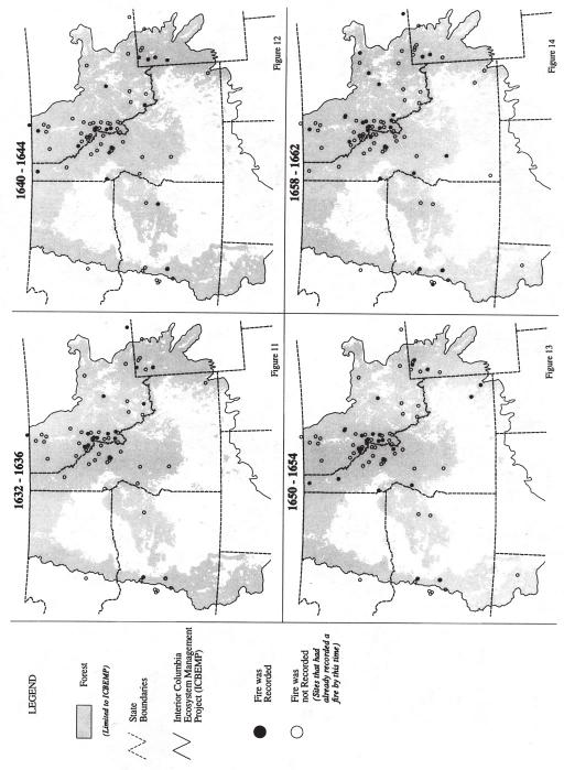
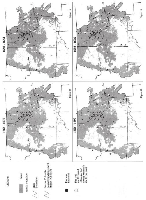
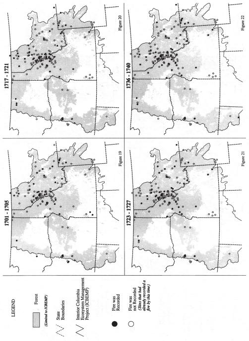
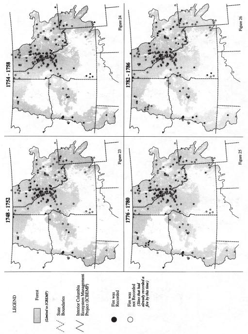
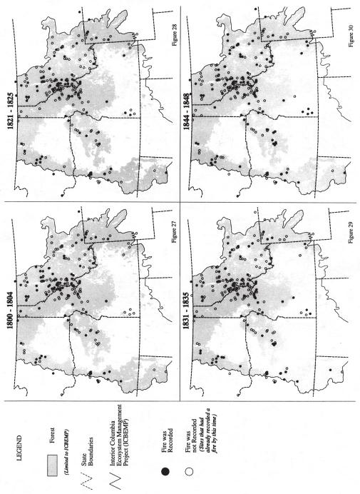
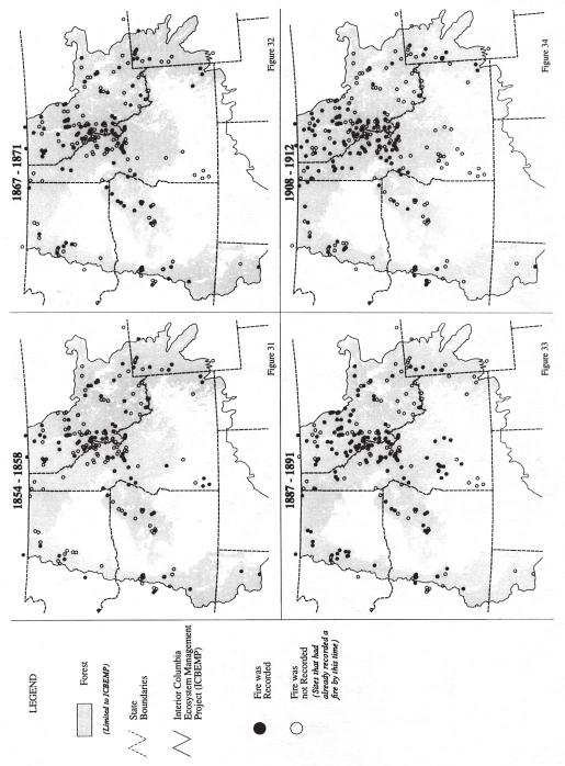
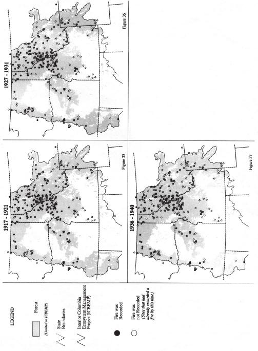
5 of fire year estimates was conducted, beginning with 1500 ±2, 1501 ±2, 1502 ±2, and so forth up to A running tally was used to reduce the effect of estimation errors by smoothing the annual frequency curve (Diggle 1990; Howarth and Rogers 1992). For instance, ca fires are represented by all data indicating fires between 1887 and The fire history database (Barrett 1995a) was also compared with dendrochronological records of regional drought (Barrett 1995b). Fire occurrence (expressed in percent of sites) was summarized by first averaging the 5 year running tally (divided by 5) used in fire episodes and then dividing by the average number of potential recording sites. The latter are sites that could have recorded a given fire episode because they had previously recorded fires (Arno and Sneck 1977; Kilgore and Taylor 1979). Results of the fire occurrence analysis were graphed relative to periods of substantially below average tree ring growth (on dry sites) indicative of regional drought as identified by Keen (1937) and Graumlich (1987). To quantify acreages burned, we started with estimates of the areas occupied by historic vegetation types in this region from the ICBEMP study by Losensky (1995). Estimates are based on compilation and synthesis of numerous early 1900s forest and vegetation surveys for individual counties and other areas throughout the region. We took the area of each major vegetation type and divided it by the corresponding mean fire intervals (site fire interval as in Arno and Petersen [1983]) to estimate the mean annual area burned. Where possible, mean fire intervals for vegetation types were taken from Barrett s (1995a) database. For types having limited data in the ICBEMP region, mean fire intervals were estimated using available literature from the Western United States. Results and Discussion Regional Fire Episodes The database contains 4,360 fire records from 122 sources (fire history studies, fire atlases, written accounts). The records are from 324 sites with discrete latitudinal and longitudinal coordinates for geographic information system (GIS) mapping. Most data were from 108 fire history studies with a total of 979 sample stands. About one-third of these studies have been published (Agee 1993). The data are unevenly distributed across the region, with about 80 percent coming from the northern Rocky Mountains (fig. 2). About 73 percent of the fire records were obtained from fire scars, 17 percent from fire atlases and other written records, and 10 percent from analysis of postfire age classes of seral trees (Barrett and Arno 1988). About 90 percent of all fire records were from the following four cover types: ponderosa pine (Pinus ponderosa), lodgepole pine (P. contorta), interior Douglas-fir (Pseudotsuga menziesii var. glauca), and western larch (Larix occidentalis). These four were the most extensive historic forest cover types in the Interior Columbia River Basin, comprising about three-forths of the forested area (Losensky 1995). Our maps (fig. 3 to 37) show fire locations during the 35 fire episodes between 1540 and 1940 when fire data were most abundant. Each fire episode map shows all potential recording sites as well as all sites that actually recorded fire. Visual examination of the fire episode maps indicates at least nine instances of extensive fire activity in the ICBEMP study region prior to Circa 1889 fires (fig. 33) provide the most compelling evidence of extensive burning (table 1) and widespread 1889 fires are confirmed by numerous contemporary accounts, such as in the Idaho Daily Statesman (Boise, ID 1889) and other newspapers (Taylor 1989). Fire episodes centered at 1869, 1856, 1846, 1833, 1823, 1802, 1784, and 1778 also show an impressive extent of fires. Data diminish markedly prior to the mid-1700s because of decreasing numbers of trees old enough to record earlier fires. Still, as far back as the 1580s (fig. 7, 8) the regional extent of fire episodes remains impressive. The average number of years between the 35 fire episodes is about 12. Recent extensive fire occurrences in this region, such as in 1988, 1994, and 1996, produced a large proportion of stand replacement burning in all forest types (Babbitt 1995). By comparison, pre-1900 fires were characterized by less stand replacement burning and more mixed severity fire and nonlethal underburning (Agee 1993; Brown 1995; Brown and others 1994; Quigley and others 1996). Much of the pre-1900 burned area was in ponderosa pine and pinemixed conifer types that burned frequently but primarily in nonlethal underburns (Agee 1993; Arno and others 1995). Area Burned Our data cannot be used to deduce whether the episodes of widespread fire (fig. 3 to 37) resulted from numerous small fires or from extensive landscape burning. However, calculating mean annual burned acreages for major vegetation types provided some quantification of the extent of burning during the fire episodes. For example, Losensky (1995) estimated that historically the ponderosa pine type occupied about 24 million acres, while sagebrush and bunchgrass types covered about 100 million acres. Average pre-1900 fire intervals were 20 years (site fire intervals as described in Agee 1993; Arno and Petersen 1983) in ponderosa pine based on 252 stands in the data base (Barrett 1995a). A conservative estimate of 25 years was used for Columbia Basin sagebrush and grass (Agee 1993; Wright and Bailey 1982). Based on 3

6 4 Figure 2 Locations of the fire history sites.

7 5 Figures 3-37 Fire episodes the most abundant and widespread fire occurrences between 1540 and 1940 at the 324 sites.
8 6
9 7
10 8
11 9
12 10
13 11
14 12
15 13
16 Table 1 Number of study sites recording the 35 fire episodes (when fire data were most abundant), and calculations showing the percentage of sites recording fire per year (fig. 38). A B C D Total number of study Average number of Average number Percent of sites Midpoint sites recording study sites recording of potential recording fire Fire episode year the fire episode fire per year (A/5) recording sites per year (5 year periods) [(B/C) x 100] these intervals, average annual acreages burned in these dry types alone would have been, respectively, 1.2 and 4 million acres. Principal fire types and average fire intervals of the ICBEMP region are shown in table 2. These vegetation types covered about 80 percent of the ICBEMP region (Losensky 1995) and collectively they had a fire cycle (length of time necessary for an area equal to the entire area of the vegetation types to burn [Romme 1980]) of about 28 years. Other historic forest types that burned at long intervals would have added marginally to the total annual fire activity. Thus, the combined mean annual acreage burned for ponderosa pine, sagebrush-grass, and other forest types in the 200 million acre ICBEMP study region is estimated to have been about 6 million acres. Substantial year to year variation in the area burned is characteristic of the ICBEMP region (Agee 1993). Annual areas burned from 1916 to 1996 (Arno 1996), indicate that the most active fire years burned double the annual mean acreage, which suggests that major fire years in the historic period would have burned 12 million acres an area equal to 6 percent of the ICBEMP region. For comparison, the largest known 14
17 fire years since 1900 (1910, 1919, 1988, and 1994) have each burned 2 to 3 million acres in the ICBEMP region; about 1 million acres burned in 1996 (Arno, S., records on file at Intermountain Fire Sciences Lab, Missoula, MT). By the late 1800s, as a result of European-American settlement and associated cultivation, irrigation, and extensive livestock grazing, there were major barriers to the continuity of grassy fuels in much of the ICBEMP region. This restricted the spread of fire (Arno and Gruell 1986), and by the early 1900s, organized suppression was able to greatly reduce the area burned in low intensity fires (Agee 1993). By the late 1940s, total annual acreage burned throughout the western United States had declined (Agee 1993; Arno 1996). Drought Relationships Tree ring records from semiarid environments, such as the ponderosa pine type, provide a useful indicator of drought periods during the past few centuries in western North America (Karl and Koscielny 1982; Meko and others 1993). The ICBEMP region s moisture is primarily influenced by a Pacific maritime climatic regime and jet streams tracking inland in a northeasterly direction. During years when maritime moisture systems were scarce, a regional drought pattern developed, which is often reflected in tree ring dendrochronologies (Fritts 1976). Peak fire activity between the 1860s and the early 1920s appears to coincide with regional drought periods (fig. 38). Prior to that time, high fire occurrence and drought periods appear to be less correlated, perhaps as a result of the diminishing data base. A variety of quantitative comparisons were made between drought episodes and relative fire frequencies (Barrett 1995b), but few region-wide linkages between these drought and fire data were evident. Other highly variable factors, such as intraregional weather variations, mass ignitions from large, dry-lightning storms, and occurrence of strong winds during fire events probably accounted for the apparent indirect relationship between drought years and fire. Although long-term drought clearly facilitates burning, the majority of the 166 million acres of vegetation types shown in table 2 experiences short-term drought every year, becoming dry enough to burn for at least a few weeks even in relatively moist years. For example, 1996 was a climatically moist year that experienced short-term drought and a large amount of wildfire activity. Conclusions and Implications Fire history data from the ICBEMP region suggest that extensive fire activity occurred at least every decade or two between the mid-1500s and the early 1900s. Calculations of annual acreages burned based on fire intervals for historic vegetation types support past interpretations (Arno 1980; Losensky 1989; Mehringer and others 1977; Pyne 1982) that major fire years prior to the early 1900s burned more acreages than any fire years since then. These calculations support the conclusion of Agee (1993) that changing land use patterns and attempts to exclude fire have succeeded in greatly reducing the scope of fire on the landscape. Conversely, since the late 1970s, there has been a marked increase in annual acreage burned by wildfires in the western United States, including large areas of high-intensity burning in ponderosa pine forests where pre-1900 fires were mostly of low intensity (American Forests 1995; Arno 1996). On Federal wildlands such as National Forests, fire is now recognized as an important ecological process (USDI and USDA 1995). Unwanted wildfires will continue to be a major agent of change on landscapes of the ICBEMP region. However, today there is growing interest in a proactive approach to guide the fire process. This involves using prescribed fire and fuels management silviculture in appropriate ways to help restore and maintain biological diversity as well as sustainable commodity and aesthetic values on Federal wildlands (Babbitt 1995; Hardy and Arno 1996; Williams 1995). Table 2 Estimated areas of historic vegetation types in the ICBEMP study region (fig. 1) and average annual rate of burning. Cover type Estimated acreage a Mean fire interval b Mean annual acreage burned Millions of acres Years Millions of acres Ponderosa pine Sagebrush and bunchgrass Interior Douglas-fir and larch Western juniper (Juniperus occidentalis) Lodgepole pine Totals a from Losensky (1995). b Ponderosa pine, Interior Douglas-fir, and lodgepole pine fire intervals are from Barrett (1995) database. Sagebrush-grass is an estimate based on Wright and Bailey (1982). Western juniper was based on the same interval as Douglas-fir (Arno 1985). 15
.")
18 16 Figure 38 Fire occurrence across the ICBEMP region based on the study sites that recorded a fire divided by the total number of study sites that had begun recording fires by that year (table 1). Percentages were based on a 5 year running average that surrounded a specific year (plus and minus 2 years). The upward trend in percentage with more recent years probably results from more complete records of fires. The black vertical lines indicate the mid-points of the 35 fire episodes. Areas shaded in gray delineate periods of regional drought.
19 References Agee, J. K Fire ecology of Pacific Northwest forests. Washington, DC: Island Press. 493 p. American Forests Forest health and fire danger in inland Western forests: Proceedings of a conference; 1994 September 8-9; Spokane, WA. Washington, DC: American Forests. 236 p. Arno, S. F Forest fire history in the Northern Rockies. Journal of Forestry. 78: Arno, S. F Ecological effects and management implications of Indian Fires. In: Lotan, J. E.; Kilgore, B. M.; Fischer, W. C.; Mutch, R. W., tech. coords. Proceedings symposium and workshop on wilderness fire; 1983 November 15-18; Missoula, MT. Gen. Tech. Rep. INT-182. Ogden, UT: U.S. Department of Agriculture, Forest Service, Intermountain Forest and Range Experiment Station: Arno, S. F The seminal importance of fire in ecosystem management impetus for this publication. In: Hardy, C. C.; Arno, S. F., eds. The use of fire in forest restoration. Gen. Tech. Rep. INT-GTR-341. Ogden, UT: U.S. Department of Agriculture, Forest Service, Intermountain Research Station: 3-5. Arno, S. F.; Gruell, G. E Douglas-fir encroachment into mountain grasslands in southwestern Montana. Journal of Range Management. 275: Arno, S. F.; Petersen, T. D Variation in estimates of fire intervals: a closer look at fire history on the Bitterroot National Forest. Res. Pap. INT-301. Ogden, UT: U.S. Department of Agriculture, Forest Service, Intermountain Research Station. 8 p. Arno, S. F.; Scott, J. H.; Hartwell, M. G Age-class structure of old growth ponderosa pine/douglas-fir stands and its relationship to fire history. Res. Pap. INT-RP-481. Ogden, UT: U.S. Department of Agriculture, Forest Service, Intermountain Research Station. 25 p. Arno, S. F.; Sneck (Davis), K. M A method for determining fire history in coniferous forests of the mountain West. Gen. Tech. Rep. INT-42. Ogden, UT: U.S. Department of Agriculture, Forest Service, Intermountain Forest and Range Experimental Station. 28 p. Babbitt, B Return fire to its place in the West. Fire Management Notes. 55(4): 6-8. Barrett, S. W. 1995a. Part II: Fire regimes database for coniferous forests in the inland Northwest. Contract report INT RJVA. Missoula, MT: U.S. Department of Agriculture, Forest Service, Intermountain Research Station. 62 p. Barrett, S. W. 1995b. Part I: Coarse scale fire history in relation to macroclimatic precipitation in the Columbia River Basin. Contract report INT RJVA. Missoula, MT: U.S. Department of Agriculture, Forest Service, Intermountain Research Station. 43 p. Barrett, S. W.; Arno, S. F Increment-borer methods for determining fire history in coniferous forests. Gen. Tech. Rep. INT-244. Ogden, UT: U.S. Department of Agriculture, Forest Service, Intermountain Research Station. 15 p. Brown, J. K Fire regimes and their relevance to ecosystem management. In: Proceedings of Society of American Foresters National Convention; 1994 September 18-22; Anchorage, AK. Bethesda, MD: Society of American Foresters: Brown, J. K.; Arno, S. F.; Barrett, S. W.; Menakis, J. P Comparing the prescribed natural fire program with presettlement fires in the Selway-Bitterroot Wilderness. International Journal of Wildland Fire. 4: Diggle, P. J Time series: A biostatistical introduction. Oxford: Clarendon Press. 257 p. Fiedler, C. E.; Steele, B. M Relationship of tree growth and recruitment to fire in old growth pine/fir forests results in cross-dating. Contract report, INT RJVA. Missoula, MT: U.S. Department of Agriculture, Forest Service, Intermountain Research Station. 23 p. Fritts, H. C Tree rings and climate. London: Academic Press. 567 p. Graumlich, L. J Precipitation variation in the Pacific Northwest ( ) as reconstructed from tree rings. Annals of the Association of American Geographers. 77: Hardy, C. C.; Arno, S. F., eds The use of fire in forest restoration. Gen. Tech. Rep. INT-GTR-341. Ogden, UT: U.S. Department of Agriculture, Forest Service, Intermountain Research Station. 82 p. Haynes, R. W.; Graham, R. T.; Quigley, T. M., tech. eds A framework for ecosystem management in the Interior Columbia Basin including portions of the Klamath and Great Basins. Gen. Tech. Rep. PNW-GTR-374. Portland, OR: U.S. Department of Agriculture, Forest Service, Pacific Northwest Research Station. 66 p. Howarth, D. A.; Rogers, J. C Problems associated with smoothing and filtering of geophysical time-series data. Physical Geography. 13: Idaho Daily Statesman September 13, and October 3 issues. Boise, ID. Johnson, C. G.; Clausnitzer, R. R.; Mehringer, P. J.; Oliver, C. D Biotic and abiotic processes of eastside ecosystems: the effects of management on plant and community ecology, and on stand and landscape vegetation dynamics. Gen. Tech. Rep. PNW- GTR-322. Portland, OR: U.S. Department of Agriculture, Forest Service, Pacific Northwest Research Station. 66 p. Karl, T. R.; Koscielny, A. J Drought in the United States: Journal of Climatology. 2: Keen, F. P Climatic cycles in eastern Oregon as indicated by tree rings. Monthly Weather Review. 65: Kilgore, B. M.; Taylor, D Fire history of a sequoia-mixed conifer forest. Ecology. 60: Losensky, B. J Development and implementation of an ecosystem maintenance burning system. In: Baumgartner, D. M; Brener, D. W.; Zamora, B. A.; [and others], comps and eds. Prescribed fire in the Intermountain Region: forest site preparation and range improvement. Pullman, WA. Washington State University, Cooperative Extension: 3-6. Losensky, B. J Historical vegetation types of the Interior Columbia River Basin. Contract report INT RJVA. Missoula, MT: U.S. Department of Agriculture, Forest Service, Intermountain Research Station. [n.p.]. Madany, M. H.; Swetnam, T. W.; West, N. E Comparison of two approaches for determining fire dates from tree scars. Forestry Science. 28: Mehringer, P. J., Jr.; Arno, S. F.; Petersen, K. L Postglacial history of Lost Trail Pass Bog, Bitterroot Mountains, Montana. Arctic and Alpine Research. 9: Meko, D.; Cook, E. R.; Stahle, D. W.; Stockton, C. W.; Hughes, M. K Spatial patterns of tree-growth anomalies in the United States and southeastern Canada. Journal of Climate. 6: Pyne, S. J Fire in America: a cultural history of wildland and rural fire. Princeton, NJ: Princeton University Press. 654 p. Quigley, T. M; Haynes, R. W.; Graham, R. T., tech. eds Integrated scientific assessment for ecosystem management in the Interior Columbia Basin. Gen. Tech. Rep. PNW-GTR-382. Portland, OR: U.S. Department of Agriculture, Forest Service, Pacific Northwest Research Station. 303 p. Romme, W Fire history terminology: report of the ad hoc committee. In: Stokes, Marvin A.; Dieterich, John H., tech. coords. Proceedings of the fire history workshop; 1980 October 20-24; Tucson, AZ. Gen. Tech. Rep. RM-81. Fort Collins, CO: U.S. Department of Agriculture, Forest Service, Rocky Mountain Forest and Range Experiment Station: Stokes, M. A.; Smiley, T. L Introduction to tree-ring dating. Chicago, IL: University of Chicago Press. 73 p. Taylor, O. J Montana 1889: the centennial news melange. Virginia City, MT 59755: O. J. Taylor, P.O. Box 97. [privately published]. 166 p. U.S. Department of Interior and U.S. Department of Agriculture Federal wildland fire management policy and program review. Final report. December 18, p. Williams, J Firefighter safety in changing forest ecosystems. Fire Management Notes. 55(3): 6-9. Wright, H. A.; Bailey, A. W Fire ecology United States and southern Canada. New York: John Wiley and Sons. 501 p. 17
20 Barrett, Stephen W.; Arno, Stephen F.; Menakis, James P Fire episodes in the Inland Northwest ( ) based on fire history data. Gen. Tech. Rep. INT-GTR-370. Ogden, UT: U.S. Department of Agriculture, Forest Service, Intermountain Research Station. 17 p. Presents maps of major fire episodes in the inland northwestern United States between 1540 and 1940 based on a compilation of fire history studies. Estimates annual acreage historically burned in this region and compares that with recent fire years. Keywords: landscape ecology, disturbance patterns, wildfire, prescribed fire, Columbia River Basin INTERMOUNTAIN RESEARCH STATION The Intermountain Research Station provides scientific knowledge and technology to improve management, protection, and use of the forests and rangelands of the Intermountain West. Research is designed to meet the needs of National Forest managers, Federal and State agencies, industry, academic institutions, public and private organizations, and individuals. Results of research are made available through publications, symposia, workshops, training sessions, and personal contacts. The Intermountain Research Station territory includes Montana, Idaho, Utah, Nevada, and western Wyoming. Eighty-five percent of the lands in the Station area, about 231 million acres, are classified as forest or rangeland. They include grasslands, deserts, shrublands, alpine areas, and forests. They provide fiber for forest industries, minerals and fossil fuels for energy and industrial development, water for domestic and industrial consumption, forage for livestock and wildlife, and recreation opportunities for millions of visitors. Several Station units conduct research in additional western States, or have missions that are national or international in scope. The United States Department of Agriculture (USDA) prohibits discrimination in its programs on the basis of race, color, national origin, sex, religion, age, disability, political beliefs, and marital or familial status. (Not all prohibited bases apply to all programs.) Persons with disabilities who require alternative means for communication of program information (braille, large print, audiotape, etc.) should contact USDA s TARGET Center at (voice and TDD). To file a complaint, write the Secretary of Agriculture, U.S. Department of Agriculture, Washington, DC 20250, or call (voice) or (TDD). USDA is an equal employment opportunity employer. Federal Recycling Program Printed on Recycled Paper
Rapid Assessment Reference Condition Model
 R0ms Rapid Assessment Reference Condition Model The Rapid Assessment is a component of the LANDFIRE project. Reference condition models for the Rapid Assessment were created through a series of expert
Mountain pine beetle attack in ponderosa pine: Comparing methods for rating susceptibility
 United States Department of Agriculture Forest Service Rocky Mountain Research Station Research Paper RMRS RP 26 September 2000 Mountain pine beetle attack in ponderosa pine: Comparing methods for rating
Colorado Front Range Fuel Photo Series
 Colorado Front Range Fuel Photo Series Michael A. Battaglia Jonathan M. Dodson Wayne D. Shepperd Mark J. Platten Owen M. Tallmadge General Technical Report RMRS-GTR-1WWW United States Department of Agriculture
Forest Resources of the Lolo National Forest
 United States Department of Agriculture Forest Service Rocky Mountain Research Station June 2000 Forest Resources of the Lolo National Forest Larry T. DeBlander About the author Larry T. DeBlander is a
Forest Resources of the Uinta National Forest
 United States Department of Agriculture Forest Service Intermountain Research Station August 1997 Forest Resources of the Uinta National Forest Renee A. O Brien Dennis Collins This summary of the forest
Forest Resources of the Wasatch-Cache National Forest
 United States Department of Agriculture Forest Service Intermountain Research Station July 1997 Forest Resources of the Wasatch-Cache National Forest Renee A. O Brien Reese Pope This summary of the forest
Financial Analysis of Fuel Treatments on National Forests in the Western United States
 United States Department of Agriculture Forest Service Pacific Northwest Research Station Research Note PNW-RN-555 Financial Analysis of Fuel Treatments on National Forests in the Western United States
Mapping the Cheatgrass-Caused Departure From Historical Natural Fire Regimes in the Great Basin, USA
 Mapping the Cheatgrass-Caused Departure From Historical Natural Fire Regimes in the Great Basin, USA James P. Menakis 1, Dianne Osborne 2, and Melanie Miller 3 Abstract Cheatgrass (Bromus tectorum) is
Forest Resources of the Ashley National Forest
 United States Department of Agriculture Forest Service Intermountain Research Station December 1997 Forest Resources of the Ashley National Forest Renee A. O Brien Ronald P. Tymcio This summary of the
Softwood Lumber Prices for Evaluation of Small-Diameter Timber Stands in the Intermountain West
 United States Department of Agriculture Forest Service Forest Products Laboratory Research Note FPL RN 0270 Softwood Lumber Prices for Evaluation of Small-Diameter Timber Stands in the Intermountain West
Harvest, Employment, Exports, and Prices in Pacific Northwest Forests,
 Pacific Northwest Research Station Harvest, Employment, Exports, and Prices in Pacific Northwest Forests, 1965 2000 General Technical Report PNW-GTR-547 July 2002 Debra D. Warren United States Department
Fire-Climate Interactions in the Selway- Bitterroot Wilderness Area
 Fire-Climate Interactions in the Selway- Bitterroot Wilderness Area Kurt F. Kipfmueller Thomas W. Swetnam Abstract Tree-ring reconstructed summer drought was examined in relation to the occurrence of 15
Fire Regimes and Pyrodiversity
 ESPM 134 Scott Stephens Fire Regimes and Pyrodiversity 1) Fire regimes consist of 5 components: - A measurement of fire frequency such as the mean fire return interval or median fire return interval. Fire
Effect of Cattle Grazing, Seeded Grass, and an Herbicide on Ponderosa Pine Seedling Survival and Growth
 United States Department of Agriculture Forest Service Pacific Southwest Research Station http://www.psw.fs.fed.us/ Research Paper PSW-RP-242 Effect of Cattle Grazing, Seeded Grass, and an Herbicide on
Six-Year Post-Fire Mortality and Health of Relict Ponderosa Pines in the Bob Marshall Wilderness Area, Montana
 Rocky Mountain Research Station Research Note United States Department of Agriculture Forest Service Rocky Mountain Research Station Research Note RMRS-RN-42 February 2011 Six-Year Post-Fire Mortality
Reconstructing Fire History of Lodgepole Pine on Chagoopa Plateau, Sequoia National Park, California 1
 Reconstructing Fire History of Lodgepole Pine on Chagoopa Plateau, Sequoia National Park, California 1 Anthony C. Caprio 2 Abstract Information on fire s role in pre-twentieth-century lodgepole pine forests
Ecosystem-Based Management in the Lodgepole Pine Zone
 Ecosystem-Based Management in the Lodgepole Pine Zone Colin C. Hardy Robert E. Keane Catherine A. Stewart Abstract The significant geographic extent of lodgepole pine (Pinus contorta) in the interior West
Forest Resources of the Black Hills National Forest
 United States Department of Agriculture Forest Service Rocky Mountain Research Station August 22 Forest Resources of the Black Hills National Forest Larry T. DeBlander About the author Larry T. DeBlander
Colorado Front Range Fire Study Questions Conventional Wisdom about Fire Regimes
 Colorado Front Range Fire Study Questions Conventional Wisdom about Fire Regimes Nine large fires have occurred on the Colorado Front Range since the turn of the century, beginning with the 2002 Hayman
An Analysis of Forest Fire History on the Little Firehole River Watershed, Yellowstone National Park
 University of Wyoming National Park Service Research Center Annual Report Volume 1 1st Annual Report, 1977 Article 16 1-1-1977 An Analysis of Forest Fire History on the Little Firehole River Watershed,
USDA FOREST SERVICE. Appendix C. Draft Post-fire Grazing Policy. Roger W. Williams 12/2/2003
 USDA FOREST SERVICE Appendix C Draft Post-fire Grazing Policy Roger W. Williams 12/2/2003 Post-Fire Grazing Interim Guidelines will be used for all project analysis involving grazing in areas that have
Fire Resilience in Moist Mixed Conifer Forests. Penelope Morgan Dept. Forest, Rangeland, and Fire Sciences University of Idaho
 Fire Resilience in Moist Mixed Conifer Forests Penelope Morgan Dept. Forest, Rangeland, and Fire Sciences University of Idaho pmorgan@uidaho.edu We live in a fire environment School Fire, Photo by Leigh
Decision Memo Raptor 1 and 9 Prescribed Burns Project
 Decision Memo Raptor 1 and 9 Prescribed Burns Project USDA Forest Service Chemult Ranger District, Fremont-Winema National Forests Klamath County, OR Township (T) 29 South (S), Range (R) 6 East (E), Section
Thinning, Fuel Manipulation and Prescribed Fire in Dry Forest Types
 Thinning, Fuel Manipulation and Prescribed Fire in Dry Forest Types Bob Rich Forest Management Supervisor, Missoula Unit. Montana Department of Natural Resources and Conservation: Missoula, Montana ABSTRACT
Engineering Watershed, Soil, & Air
 Engineering Watershed, Soil, & Air United States Department of Agriculture Forest Service Technology & Development Program December 2008 2500/7100 0871 2346 MTDC Using Scarification, Wood Shreddings, and
Forest Resources of the Fishlake National Forest
 United States Department of Agriculture Forest Service Rocky Mountain Research Station May 1998 Forest Resources of the Fishlake National Forest Renee A. O Brien Shirley H. Waters An extensive, comprehensive
Historic Resource Production From USDA Forest Service Northern and Intermountain Region Lands
 United States Department of Agriculture Forest Service Pacific Northwest Research Station Research Note PNW-RN-540 June 1999 Historic Resource Production From USDA Forest Service Northern and Intermountain
Forest Resources of the Beaverhead- Deerlodge National Forest
 United States Department of Agriculture Forest Service Rocky Mountain Research Station August 21 Forest Resources of the Beaverhead- Deerlodge National Forest Larry T. DeBlander Beaverhead-Deerlodge National
Forecasting Timber, Biomass, and Tree Carbon Pools with the Output of State and Transition Models
 Proceedings of the First Landscape State-and-Transition Simulation Modeling Conference, June 14 16, 2011 Forecasting Timber, Biomass, and Tree Carbon Pools with the Output of State and Transition Models
United States Department of Agriculture. Forest Service. Beaverhead-Deerlodge National Forest. September 2014
 United States Department of Agriculture Forest Service Beaverhead-Deerlodge National Forest September 2014 Beaverhead-Deerlodge National Forest Land and Resource Management Plan Explanation Supporting
TAXONOMY. Cultivar. Washington State Distribution (1)
") Plant Propagation Protocol for Juniperus occidentalis ESRM 412 Native Plant Production Protocol URL: https://courses.washington.edu/esrm412/protocols/juoc.pdf TAXONOMY Plant Family Cypress family Scientific
Plant Propagation Protocol for Juniperus occidentalis ESRM 412 Native Plant Production Protocol URL: https://courses.washington.edu/esrm412/protocols/juoc.pdf TAXONOMY Plant Family Cypress family Scientific
2016- Faculty Research Associate, Department of Forest Engineering, Resources, and Management, Oregon State University, Corvallis, OR
 James D. Johnston Email: james.johnston@oregonstate.edu Cell: (541) 554-1151 CURRENT POSITION 2016- Faculty Research Associate, Department of Forest Engineering, Resources, and Management, Oregon State
U.S. Forest Facts and Historical Trends
 Errata In the printed version of this brochure the graphics on page 13 should be in Billion cubic feet. The following pdf version of the brochure has been corrected. U.S. Forest Facts and Historical Trends
Strategic Fuel Treatment Placement Plan Mt. Hood National Forest April 2012
 Strategic Fuel Treatment Placement Plan Mt. Hood National Forest April 2012 OVERVIEW The Mt. Hood National Forest Strategic Fuel Treatment Placement Plan (hereafter Strategic Fuel Treatment Plan, 2012),
USING PRESCRIBED FIRE TO REDUCE THE RISK OF LARGE WILDFIRES: A BREAK-EVEN ANALYSIS 1. James M. Saveland 2. University of Idaho Moscow, Idaho
 USING PRESCRIBED FIRE TO REDUCE THE RISK OF LARGE WILDFIRES: A BREAK-EVEN ANALYSIS 1 1. INTRODUCTION James M. Saveland 2 University of Idaho Moscow, Idaho Nearly all wildfires are extinguished when they
Why does the Forest Service need to propose this activity at this time?
 United States Department of Agriculture Forest Service Uinta-Wasatch-Cache NF Supervisor s Office www.fs.usda.gov/uwcnf 857 W. South Jordan Parkway South Jordan, UT 84095 Tel. (801) 999-2103 FAX (801)
Users Guide for Noble Fir Bough Cruiser
 United States Department of Agriculture Forest Service Pacific Northwest Research Station General Technical Report PNW-GTR-644 July 2005 Users Guide for Noble Fir Bough Cruiser Roger D. Fight, Keith A.
Winter Wheat Seedings
 Washington, D.C. Winter Wheat Seedings Released January 12, 2007, by the National Agricultural Statistics Service (NASS),, U.S. Department of Agriculture. For information on Winter Wheat Seedings call
National Best Management Practices Monitoring Summary Report
 United States Department of Agriculture National Best Management Practices Monitoring Summary Report Fiscal Year 2013 Forest Service FS-1042 January 2015 United States Department of Agriculture Forest
General Location: Approximately 6 miles east of Huntsville, Utah along the South Fork of the Ogden River (Figure 1)
") PUBLIC SCOPING SOUTH FORK WUI OGDEN RANGER DISTRICT, UINTA-WASATCH-CACHE NATIONAL FOREST WEBER COUNTY, UTAH OCTOBER 6, 2017 1.0 INTRODUCTION The Ogden Ranger District of the Uinta-Wasatch-Cache National
PUBLIC SCOPING SOUTH FORK WUI OGDEN RANGER DISTRICT, UINTA-WASATCH-CACHE NATIONAL FOREST WEBER COUNTY, UTAH OCTOBER 6, 2017 1.0 INTRODUCTION The Ogden Ranger District of the Uinta-Wasatch-Cache National
Plant Propagation Protocol for Larix occidentalis. Picture taken by Dylan Holm (Western Larch in the fall)
") Plant Propagation Protocol for Larix occidentalis Picture taken by Dylan Holm (Western Larch in the fall) Picture acquired from www.dkimages.com ESRM 412 Native Plant Production Spring 2008 Family Names
Plant Propagation Protocol for Larix occidentalis Picture taken by Dylan Holm (Western Larch in the fall) Picture acquired from www.dkimages.com ESRM 412 Native Plant Production Spring 2008 Family Names
Dendrochronology, Fire Regimes
 Dendrochronology, Fire Regimes Peter M. Brown* Rocky Mountain Tree-Ring Research, Inc., Fort Collins, CO, USA Definition Use of tree-ring data and methods to reconstruct past fire timing, fire regimes,
Winter Wheat Seedings
 Washington, D.C. Winter Wheat Seedings Released January 12,, by the National Agricultural Statistics Service (NASS),, U.S. Department of Agriculture. For information on Winter Wheat Seedings call Todd
Determining the Disturbance Effect on Forest Development for Use in Park Management Plans
 Determining the Disturbance Effect on Forest Development for Use in Park Management Plans Bruce Larson, Faculty of Forestry, University of British Columbia, 2329 West Mall, Vancouver, BC V6T 1Z4, Canada;
Wildfires and Climate Change in the Western US
 Wildfires and Climate Change in the Western US Biscuit Complex Fire, July 13 Sept. 5, 22, 499,965 acres 22 Megafires in the Western U.S Hayman Fire, June 8 July 2, 22, 138, acres Thomas W. Swetnam Laboratory
Annotated Bibliography
 Annotated Bibliography 79 79 80 Annotated Bibliography of Publications for LAC Applications Stephen F. McCool David N. Cole Workshop participants suggested that one worthwhile addition to the proceedings
Estimating Historical Snag Density in Dry Forests East of the Cascade Range
 United States Department of Agriculture Forest Service Pacicic Northwest Research Station General Technical Report PNW-GTR-428 August 1998 Estimating Historical Snag Density in Dry Forests East of the
Lake Fire Restoration and Hazardous Tree Removal. Project Proposed Action and Scoping Document
 United States Department of Agriculture Forest Service November 2016 Lake Fire Restoration and Hazardous Tree Removal Heather McRae Project Proposed Action and Scoping Document USDA Forest Service Shasta-Trinity
Fire ecology of ponderosa pine
 Fire ecology of ponderosa pine Historically, fires were frequent (every 2-25 yr) and predominantly nonlethal Droughts are common Biomass production exceeds decomposition Ignition is not limiting: lightning
TO THE SUBCOMMITTEE ON FORESTS AND FOREST HEALTH, COMMITTEE ON RESOURCES, U.S. HOUSE OF REPRESENTATIVES
 TESTIMONY TO THE SUBCOMMITTEE ON FORESTS AND FOREST HEALTH, COMMITTEE ON RESOURCES, U.S. HOUSE OF REPRESENTATIVES Penelope Morgan, Professor, College of Natural Resources, University of Idaho, Moscow,
Fire History and Stand Structure of a central Nevada. Pinyon-Juniper Woodland
 Fire History and Stand Structure of a central Nevada Pinyon-Juniper Woodland EXECUTIVE SUMMARY AND FINAL REPORT A Report to the Bureau of Land Management, Nevada State Office September, 2006 Peter J. Weisberg
Rapid Assessment Reference Condition Model
 R3ASPN Rapid Assessment Reference Condition Model The Rapid Assessment is a component of the LANDFIRE project. Reference condition models for the Rapid Assessment were created through a series of expert
Wildlife Conservation Strategy
 Wildlife Conservation Strategy Boise National Forest What is the Wildlife Conservation Strategy? The Boise National Forest is developing a Wildlife Conservation Strategy (WCS) in accordance with its Land
Climate Change. Introduction
 Climate Change This environmental assessment incorporates by reference (as per 40 CFR 1502.21) the Climate Change specialists report and other technical documentation used to support the analysis and conclusions
Wildland-Urban Interface/Fire Management Specialist Report Kiowa, Rita Blanca, Black Kettle and McClellan Creek National Grasslands Plan Revision
 United States Department of Agriculture Forest Service Southwestern Region Cibola National Forest and National Grasslands May 2011 Wildland-Urban Interface/Fire Management Specialist Report Kiowa, Rita
Reintroducing Fire in Regenerated Dry Forests Following Stand-Replacing Wildfire 1
 Reintroducing Fire in Regenerated Dry Forests Following Stand-Replacing Wildfire 1 David W. Peterson, 2 Paul F. Hessburg, 2 Brion Salter, 2 Kevin M. James, 2 Matthew C. Dahlgreen, 3 and John A. Barnes
Walton Lake Restoration Project
 Walton Lake Restoration Project Fire and Fuels Specialist Report, February 2017 Ochoco National Forest Lookout Mtn. Ranger District Barry Kleckler Fuels Specialist, Prairie Division, Central Oregon Fire
Forest Fire History in Relation to Landscape Diversity on the Little Firehole River Watershed, Yellowstone National Park
 University of Wyoming National Park Service Research Center Annual Report Volume 3 3rd Annual Report, 1979 Article 24 1-1-1979 Forest Fire History in Relation to Landscape Diversity on the Little Firehole
Bioe 515. Disturbance and Landscape Dynamics
 Bioe 515 Disturbance and Landscape Dynamics The Rocky Mountains, Lander's Peak, 1863 Albert Bierstadt (American, 1830 1902) 1895 Natural Disturbance? 1980 Fire Exclusion? Disturbance Cannot be Ignored
REINTRODUCING FIRE IN PONDEROSA PINE-FIR FORESTS AFTER A CENTURY OF FIRE EXCLUSION
 REINTRODUCING FIRE IN PONDEROSA PINE-FIR FORESTS AFTER A CENTURY OF FIRE EXCLUSION Carl E. Fiedler School of Forestry, University of Montana, Missoula, MT 59812 Stephen E Arno and Michael G. Harrington
Herbaceous Stubble Height as a Warning of Impending Cattle Grazing Damage to Riparian Areas
 United States Department of Agriculture Forest Service Pacific Northwest Research Station General Technical Report PNW-GTR-362 September 1995 Herbaceous Stubble Height as a Warning of Impending Cattle
Telegraph Forest Management Project
 Telegraph Forest Management Project Black Hills National Forest Northern Hills Ranger District Lawrence and Pennington Counties, South Dakota Proposed Action and Request for Comments March 2008 Table of
Mapping Mountain Pine Beetle and White Pine Blister Rust in White Bark Pine on the Helena National Forest
 Numbered Report 06-05 March 2006 Mapping Mountain Beetle and White Blister Rust in White Bark on the Helena National Forest Introduction Nancy Sturdevant, Entomologist USDA Forest Service, Forest Health
D E P A R T M E N T S
 D E P A R T M E N T S Technological Tools Note: Dr. David Inouye is the editor of the Technological Tools section. Anyone wishing to contribute articles or reviews to this section should contact him at
Eight-year Tree Growth Following Prescribed Underburning in a Western Montana Douglas-fir/ Western Larch Stand
 United States Department of Agriculture Forest Service Intermountain Research Station Research Note INT-387 December 1988 This file was created by scanning the printed publication. Errors identified by
Sage Steppe Ecosystem Restoration Strategy
 United States Department of Agriculture Forest Service Pacific Southwest Region R5-MB-161 September 2008 Sage Steppe Ecosystem Restoration Strategy Record of Decision Modoc National Forest The U.S. Department
CROWN FIRE ASSESSMENT IN THE URBAN INTERMIX: MODELING THE SPOKANE, WASHINGTON PONDEROSA PINE FORESTS
 CROWN FIRE ASSESSMENT IN THE URBAN INTERMIX: MODELING THE SPOKANE, WASHINGTON PONDEROSA PINE FORESTS Douglas A. Graves and Leon F. Neuenschwander Department of forest Resources University of Idaho Moscow,
Climate Change in the Greater Yellowstone Area: 1900-Present and Forecast to 2100
 Climate Change in the Greater Yellowstone Area: 1900-Present and Forecast to 2100 Andrew Hansen, Montana State University Tom Olliff, Great Northern LCC and NPS IMR Tony Chang, Montana State University
PHOTO GUIDE FOR APPRAISING DOWNED WOODY MASTICATED FUELS IN INTERIOR PONDEROSA PINE FORESTS ON THE COLORADO FRONT RANGE
 PHOTO GUIDE FOR APPRAISING DOWNED WOODY MASTICATED FUELS IN INTERIOR PONDEROSA PINE FORESTS ON THE COLORADO FRONT RANGE PART ONE OF A FOUR-PART SERIES ON INTERIOR PONDEROSA PINE, GAMBEL OAK, MIXED CONIFER
Sparta Vegetation Management Project
 Sparta Vegetation Management Project Social and Economics Report Prepared by: John Jesenko Presale/Forest Measurements Specialist /s/ John Jesenko for: Whitman Ranger District Wallowa-Whitman National
Alpine larch (La) - Larix lyallii
 - Larix lyallii") Alpine larch (La) - Larix lyallii Tree Species > Alpine larch Page Index Distribution Range and Amplitiudes Tolerances and Damaging Agents Silvical Characteristics Genetics and Notes BC Distribution of
Alpine larch (La) - Larix lyallii Tree Species > Alpine larch Page Index Distribution Range and Amplitiudes Tolerances and Damaging Agents Silvical Characteristics Genetics and Notes BC Distribution of
Watershed Health in Wilderness, Roadless, and Roaded Areas of the National Forest System
 Watershed Health in Wilderness, Roadless, and Roaded Areas of the National Forest System By Mike Anderson, J.D. 1, Collene Gaolach, M.S. 2, Janice Thomson, Ph.D. 3, and Greg Aplet, Ph.D. 4 Introduction
FOR 426 Fire Management and Ecology
 Fire ecology and ecological restoration in whitebark pine ecosystems Penny Morgan In this presentation, we ll focus on the fire ecology and ecological restoration of whitebark pine. This is an interesting
Ponderosa pine (Py) - Pinus ponderosa
 - Pinus ponderosa") Ponderosa pine (Py) - Pinus ponderosa Tree Species > Ponderosa pine Page Index Distribution Range and Amplitiudes Tolerances and Damaging Agents Silvical Characteristics Genetics and Notes BC Distribution
Ponderosa pine (Py) - Pinus ponderosa Tree Species > Ponderosa pine Page Index Distribution Range and Amplitiudes Tolerances and Damaging Agents Silvical Characteristics Genetics and Notes BC Distribution
Spatial Analysis of Fuel Treatment Options for Chaparral on the Angeles National Forest 1
 Spatial Analysis of Fuel Treatment Options for Chaparral on the Angeles National Forest 1 Greg Jones, 2 Jim Chew, 2 Robin Silverstein, 2 Chris Stalling, 2 Janet Sullivan, 2 Judy Troutwine, 3 David Weise,
Ecological Restoration on the Klamath National Forest
 Ecological Restoration on the Klamath National Forest Dan Blessing Natural Resources Staff Officer Uncles Complex Klamath National Forest 08/17/2006 09:00 Objectives Policy overview What does it look like?
Creating Wildlife Habitat Conditions
 Creating Wildlife Habitat Conditions Dale L Wills TABLE OF CONTENTS INTRODUCTION...245 SUBALPINE FOREST AND DOUGLAS FIR...246 Grass-forb Stage...246 Shrub-seedling Stage...247 Sapling-pole Stage...247
Climate change, fire, insects, and disturbance interactions: adaptation challenges in the West
 http://www.yakima.net/ Climate change, fire, insects, and disturbance interactions: adaptation challenges in the West W Climate Impacts Group Don McKenzie Pacific Wildland Fire Sciences Lab U.S. Forest
Contents. 1 Introduction. 2 Data. 3 Analysis. 4 Equations for Height Growth. 8 Equations for Site Index. 14 Discussion
 United States Department of Agriculture Forest Service Pacific Northwest Research Station Research Paper PNW-RP-378 Estimates of Site Index and Height Growth for Douglas-Fir in High- Elevation Forests
Forest Resources of the Coconino National Forest
 United States Department of Agriculture Forest Service Rocky Mountain Research Station May 2003 Forest Resources of the Coconino National Forest Larry T. DeBlander Mark Fleck About the author Larry T.
Recent wildfires provide harsh testimony to the hazardous forest
 Reducing Crown Fire Hazard in Fire-Adapted Forests of New Mexico Carl E. Fiedler 1 and Charles E. Keegan 2 Abstract Analysis of FIA data for New Mexico shows that 2.4 million acres of ponderosa pine and
Stocking Levels and Underlying Assumptions for Uneven-Aged Ponderosa Pine Stands
 United States Department of Agriculture Forest Service Pacific Northwest Research Station Research Note PNW-RN-509 February 1992 Stocking Levels and Underlying Assumptions for Uneven-Aged Ponderosa Pine
General Information. Reviewers Stanley G. Kitchens Henry Bastian Sandy Gregory
 R2 Rapid Assessment Reference Condition Model The Rapid Assessment is a component of the LANDFIRE project. Reference condition models for the Rapid Assessment were created through a series of expert workshops
Fire History in the Colorado Rockies
 Fire History in the Colorado Rockies Brief overview of fire regimes in different forest ecosystem types Relationship of wildfire activity to climate variability Effects of fire exclusion and fire suppression
FOR 426 Fire Management and Ecology
 Fire history methods by Penny Morgan Natural archives of fire history data Dated fire scars in tree rings: yr and season Time-since-fire maps reconstructed from ages of trees, usually from even-aged stands
Rapid Assessment Reference Condition Model
 R3PGmst Rapid Assessment Reference Condition Model The Rapid Assessment is a component of the LANDFIRE project. Reference condition models for the Rapid Assessment were created through a series of expert
Fire-Return Intervals in Mixed-Conifer Forests of the Kings River Sustainable Forest Ecosystems Project Area 1
 Fire-Return Intervals in Mixed-Conifer Forests of the Kings River Sustainable Forest Ecosystems Project Area 1 Catherine Phillips 2 Abstract Fire-return intervals were studied on six 1.4-ha plots in a
Farms and Land in Farms
 United States Department of Agriculture National Agricultural Statistics Service Farms and Land in Farms February 2003 Sp Sy 3 (03) Up Slightly in 2002 The number of farms in the United States in 2002
THE SAN DIEGO DECLARATION ON CLIMATE CHANGE AND FIRE MANAGEMENT
 THE SAN DIEGO DECLARATION ON CLIMATE CHANGE AND FIRE MANAGEMENT THE ASSOCIATION FOR FIRE ECOLOGY Presented at THIRD INTERNATIONAL FIRE ECOLOGY AND MANAGEMENT CONGRESS 1, 2 November 13-17, 2006 PREAMBLE
Land Values 2013 Summary
 United States Department of Agriculture National Agricultural Statistics Service Land Values 2013 Summary August 2013 ISSN: 19491867 Contents Agricultural Land Values Highlights... 4 Farm Real Estate,
Huron-Manistee National Forests Mio Ranger District 107 McKinley Road Mio, MI 48647
 United States Department of Agriculture Forest Service Huron-Manistee National Forests Mio Ranger District 107 McKinley Road Mio, MI 48647 989-826-3252 (Voice) 989-826-6073 (Fax) Dial 711 for relay service
Adapting to Climate Change in Western National Forests
 Adapting to Climate Change in Western National Forests David L. Peterson 1, Jessica E. Halofsky 2, Natalie Little 3 ¹USDA Forest Service, Pacific Northwest Research Station ²University of Washington, School
Rapid Assessment Reference Condition Model
 R3OCWO Rapid Assessment Reference Condition Model The Rapid Assessment is a component of the LANDFIRE project. Reference condition models for the Rapid Assessment were created through a series of expert
Great Basin Native Plant Project and BLM Plant Conservation Program: Its Role in Sage Grouse Conservation
 Great Basin Native Plant Project and BLM Plant Conservation Program: Its Role in Sage Grouse Conservation Peggy Olwell BLM Plant Conservation Program Lead March 17, 2014 Overview Native Plant Materials
Final Decision Memo. Murphy Meadow Restoration Project. USDA Forest Service Willamette National Forest McKenzie River Ranger District
 Final Decision Memo Murphy Meadow Restoration Project USDA Forest Service Willamette National Forest McKenzie River Ranger District T19S, R5E, Sec. 23, 24. Lane County Oregon BACKGROUND The Murphy Meadow
Why Wildfires Keep Getting Bigger: An Introduction to Wildland Fires in New Mexico. Mary Stuever, Chama District Forester New Mexico State Forestry
 Why Wildfires Keep Getting Bigger: An Introduction to Wildland Fires in New Mexico Mary Stuever, Chama District Forester New Mexico State Forestry Visiting Forester Program at Philmont Scout Ranch William
Forest Resources of the Shoshone National Forest
 United States Department of Agriculture Forest Service Rocky Mountain Research Station May 2008 Forest Resources of the Shoshone National Forest Jim Menlove About the author Jim Menlove is an Ecologist
Peter H. Singleton John F. Lehmkuhl. USDA Forest Service Pacific Northwest Research Station Wenatchee Forestry Sciences Lab
 Peter H. Singleton John F. Lehmkuhl USDA Forest Service Pacific Northwest Research Station Wenatchee Forestry Sciences Lab Talk Overview: Wildlife community associated with MMC Considerations for wildlife
Buy Local, Buy Quality
 Buy Local, Buy Quality Benefits of using wood posts: Superior strength Ability to hold well in the soil Long-lasting durability Easy to install Maintenance free Natural beauty Throughout the West, our
Upper Valley Landscape Improvement Project
 Upper Valley Landscape Improvement Project Shrubland, Rangeland Resource and Noxious Weed Report Prepared by: Kimberly Dolatta and Jessica Warner Rangeland Management Specialist for: Escalante Ranger District