COMPREHENSIVE SURFACE WATER MANAGEMENT PLAN FOR THE CITY OF CHAMPLIN, MINNESOTA. WSB Project No DRAFT October 2008 PREPARED BY
|
|
|
- Thomas McGee
- 6 years ago
- Views:
Transcription
1 COMPREHENSIVE SURFACE WATER MANAGEMENT PLAN FOR THE CITY OF CHAMPLIN, MINNESOTA WSB Project No DRAFT PREPARED BY City of Champlin Champlin Drive Champlin, MN (763) WSB & Associates, Inc. 701 Xenia Avenue Suite 300 Minneapolis, MN (763) I hereby certify that this plan, specification or report was prepared by me or under my direct supervision and that I am a duly Registered Professional Engineer under the laws of the State of Minnesota. Todd E. Hubmer, P.E. Reg. No
2 TABLE OF CONTENTS i. TITLE PAGE ii. iv. TABLE OF CONTENTS LIST OF TABLES v. LIST OF FIGURES vi. LIST OF APPENDICES I. EXECUTIVE SUMMARY II. III. IV. INTRODUCTION AND PURPOSE LAND AND WATER RESOURCE INVENTORY PROBLEMS AND CORRECTIVE ACTIONS V. ESTABLISHMENT OF GOALS AND POLICIES VI. VII. VIII. IMPLEMENTATION PRIORITIES / IMPLEMENTATION PROGRAM FINANCIAL CONSIDERATIONS AMENDMENT PROCEDURES City of Champlin WSB Project No
3 LIST OF TABLES TABLE NO. III-1 SECTION & PAGE NO. Average Monthly Temperature, Precipitation, and Snowfall Data... III-3 III-2 VI-1 VI-2 VI-3 VI-4 Rainfall/ Runoff Events for Elm Creek Watershed.III-3 Storm Water Capital Improvement Projects... VI-3 Storm Water Management Programs... VI-5 Storm Water Management Studies... VI-7 Summary... VI-9 City of Champlin
4 LIST OF FIGURES FIGURE NO. SECTION & PAGE NO. II-1 III-1 III-2 III-3 III-4 III-5 III-6 III-7 III-8 III-9 Watershed District/Watershed Management Organization Map... II-3 1% Chance Rainfall Event in 24-hours within the State of Minnesota... III-4 Annual Normal Precipitation within the State of Minnesota... III-5 City Location... III-6 Subwatershed Delineation... III-15 National Wetland Inventory III-16 DNR Public Waters/Wetlands/Waterways... III-17 FEMA Floodplain Map... III-18 Water Resource Problem Areas... III-19 Water Quality Monitoring Locations... III-20 III-10 Water Appropriations Location... III-21 III-11 Hydrologic Soils Classification... III-22 III-12 Existing Land Use...III-23 III-13 MLCCS.III-24 III-14 Parks Map III-25 III-15 Pollutant Sources Location... III-26 City of Champlin WSB Project No
5 LIST OF APPENDICES A. Water Resource Related Agreements B. Storm Water System Modeling Information C. FEMA Flood Insurance Study D. Ordinances E. Watershed Management Commission Rules F. Wetland Management Strategies G. Wetland Seeding Mix City of Champlin WSB Project No
6 SECTION I I. EXECUTIVE SUMMARY The City of Champlin has developed this Surface Water Management Plan to not only meet the local watershed management planning requirements of the Metropolitan Surface Water Management Act and Minnesota Rules 8410, but also to provide a guide to the City, its residents, and developers on surface water management. The City knows that protecting its water resources, especially with its location on the Mississippi River, is important to the community. With this framework in mind, the City has developed a number of goals, strategies, and policies for the management of storm water within the City. The goals of the City are as follows: Goals 1. To prevent flooding. 2. To reduce to the greatest practical extent the public capital expenditures needed to correct flooding and water quality problems. 3. To improve water quality. 4. To reduce erosion and sedimentation from surface flows. 5. To preserve wetlands, lakes, and streams. 6. To promote groundwater recharge. 7. To protect and enhance fish and wildlife habitat and water recreational opportunities. 8. To secure the other benefits associated with the proper management of surface water. The policies and strategies to meet these goals are outlined within the balance of this Plan within the following sections. Section II Section II of this plan provides an introduction and purpose. The Surface Water Management Plan has been developed to provide the City with direction concerning the administration and implementation of water resource activities within the City. This plan is intended to meet the requirements for a local surface water management plan as required by the Metropolitan Surface Water Management Act and be in conformance with Board of Water and Soil Resources (BWSR) Rules Chapter This section also lists the personnel contacts involved in the assistance and implementation of this plan, including the staff from the Elm Creek Watershed Management Commission and West Mississippi Watershed Management Commission. Section III City of Champlin Section I Page 1 WSB Project No
7 SECTION I Section III of this plan provides an inventory of land and water resources within the City including a general description and summary of data related to precipitation, geology, topography, flood problem areas, existing flood insurance studies, water quality, water management ordinances, surface and ground water appropriations, ground water, soils, land use, public utilities services, public areas for water-based recreation and access, fish and wildlife habitat, unique features, scenic areas and pollutant source locations within the City. A number of maps were also developed as part of the Plan to assist in summarizing this information. Section IV Section IV of this Surface Water Management Plan provides an assessment of the existing and potential water resource related concerns within the City. These concerns were identified based on an analysis of the land and resource data collected as part of this plan preparation and through public input. A number of problem areas were identified through the plan development process. This section summarizes the problems and corrective actions that were identified through this process. Section V Section V of this plan outlines water resource management related goals and policies of the City. Goals and policies have been developed for the City concerning water quantity, water quality, recreation, fish and wildlife management, enhancement of public participation, information and education, public ditch system, ground water, wetlands, and erosion. Section VI Section VI outlines implementation priorities and develops an implementation program. This section contains a prioritized listing of the studies, programs and capital improvements that have been identified as necessary to respond to the water resource needs within the City. The implementation period identified within this report for the programs, studies and capital improvements is for 10 years or more from the adoption of this plan. Many of the improvements noted in the plan will most efficiently be implemented over time, as development occurs in the affected areas. This plan is to be used for planning purposes only. Detailed feasibility analysis has not been completed to develop this section; therefore, cost estimates are subject to change and update as more detailed information is obtained. Section VII Section VII discusses the financial considerations of implementing the proposed regulatory controls, programs and improvements, which have been identified in this plan and their financial impact on the City. Funding sources available for implementing the policies and corrective actions identified within this plan are included. Other possible funding sources for the implementation of this plan include special assessments and grant monies, which may be secured from various local, regional, County, State or Federal agencies. Section VIII City of Champlin Section I Page 2 WSB Project No
8 SECTION I Section VIII discusses the procedures to be followed in the event this Surface Water Management Plan is amended. Once this Surface Water Management Plan is approved, no significant changes to this plan can be facilitated without the approval of the proposed revisions by the Watershed Management Commissions within the City that are affected by the change. Significant changes to the plan shall be made known to the Mayor, City Council, City Staff, and the Metropolitan Council. Appendices Appendices are included in the back of the plan and are summarized below. These documents are included because they provide supporting information to the main body of the plan. Appendix A: Water Resource Related Agreements. This section contains copies of any agreements that the City has entered into regarding water resource management. Appendix B: Storm Water System Modeling Information. A summary of the storm water model that was developed for the City is included in this appendix. This includes drainage areas, high water levels, and peak discharge rates. Appendix C: FEMA Flood Insurance Study. The FEMA flood insurance study and other FEMA information is included in this appendix. Appendix D: Ordinances. The City s water resource related ordinances are included in this appendix. The most up-to-date ordinances are available on the City s web-site at Appendix E: Watershed Rules. The rules of the Elm Creek Watershed Management Commission and the West Mississippi Watershed Management Commission are included in this appendix. Appendix F: Wetland Management Strategies. Water quality and quantity requirements for wetlands in the City have been developed. The wetlands will be placed into management categories as part of the 2009 function and value assessment. Additional material is referenced within this report and is available from the Engineering Department. This document is expected to be a 10 year Surface Water Management Plan, after which time this plan should be updated. However, if significant changes to the plan are deemed necessary prior to that date the City may revise this plan in its entirety. City of Champlin Section I Page 3 WSB Project No
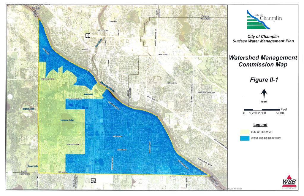
9 SECTION II II. INTRODUCTION AND PURPOSE A. General This Surface Water Management Plan has been developed to provide the City with direction concerning the administration and implementation of water resource activities within the City. This plan is intended to meet the requirements for a local surface water management plan as required by the Metropolitan Surface Water Management Act and be in conformance with Board of Water and Soil Resources (BWSR) Rules Chapter In addition to being in conformance with the above state law, this plan has also been developed to meet the needs, requirements, and direction outlined by the following list: 1. Elm Creek Watershed Management Commission 2. Shingle Creek and West Mississippi River Watershed Management Commission 3. State and Federal laws regarding the need to secure a National Pollutant Discharge Elimination System (NPDES) Storm Water Discharge permit 4. Metropolitan Council Water Resource Management Policy Plan This plan incorporates the approaches and direction provided in the programs and documents listed above into a comprehensive plan that can be consistently applied across the City. B. Personnel Contacts To implement this plan, a coordinated water resource management approach must be used. This approach utilizes the services of staff personnel within the City and surrounding communities, as well as staff associated with the various Watershed Management Commissions having jurisdiction over areas within the City. The Watershed Management Commissions having jurisdiction within the City are shown on Figure II-1. The primary implementation responsibility will lie with the appropriate staff members at the City. Assistance from the surrounding municipalities and Watershed Management Commissions will also be expected. Outlined below are the names, addresses, telephone numbers, and website address for personnel having responsibilities for overseeing or implementing various aspects of the Plan. City of Champlin Engineering Department Todd Tuominen Champlin Drive Champlin, MN (763) City of Champlin Section II Page 1 WSB Project No
10 SECTION II Elm Creek Watershed Management Commission c/o Judie Anderson 3235 Fernbrook Lane N Plymouth, MN (763) Shingle Creek and West Mississippi River Watershed Management Commission c/o Judie Anderson 3235 Fernbrook Lane N Plymouth, MN (763) Metropolitan Council Jack Frost 230 East 5th St St. Paul, MN (651) C. Water Resource Related Agreements The City has entered into water resource-related agreements that govern in part how the City must manage its water resources. These agreements include agreements between the City and adjoining communities or agreements it may have with other governmental units or private parties. Listed below is a description of the water resource related agreements which the City has entered into. A copy of these agreements or appropriate portions thereof are included in Appendix A. Agreement to establish the Shingle Creek and West Mississippi Watershed Management Commissions: This Joint Powers Agreement (JPA) outlines the purpose and responsibilities of the Commissions. Agreement to establish the Elm Creek Watershed Management Commission: This JPA outlines the purpose and responsibilities of the Commission. Maintenance Agreement for Stormwater and Infiltration Maintenance for Goose Lake Road: The agreement between the cities of Champlin and Dayton. This agreement states that the cities agree to maintain the infiltration basin and storm water management system associated with the Goose Lake Road project. City of Champlin Section II Page 2 WSB Project No
11
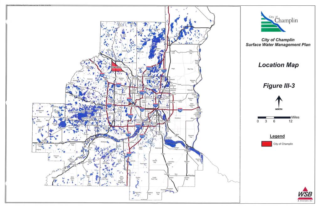
12 SECTION III III. LAND AND WATER RESOURCE INVENTORY In conformance with the Metropolitan Surface Water Management Act and as required in Minnesota Rules Section , this section of the plan provides a general description and summary of the climate, geology, surficial topography, surface and ground water resource data, soils, land use, public utilities services, water-based recreation, fish and wildlife habitat, unique features, scenic areas, and pollutant sources. This section also identifies where detailed information can be obtained for many of these areas of concern. A. Climate and Precipitation 1. Climate The climate within the Minneapolis/St. Paul metropolitan area, which includes the City of Champlin, is described as temperate with moderate precipitation, wide daily temperature variations, warm humid summers and cold winters. The average annual temperature is 45 degrees Fahrenheit (7.2 degrees Celsius). The total average annual precipitation is approximately 28 inches, of which approximately one-half occurs between the months of May and August. The annual snowfall average is about 46 inches equating to approximately 4.6 inches of liquid water. Average monthly temperature and precipitation are shown in Table III Precipitation The probability of a rainfall event occurring in any given year is illustrated in Table III-2. The recurrence interval is based on the probability that a given storm event will reoccur in any given year. The rainfall amounts for the probabilities are shown in Table III-2. The 1%, 10-day runoff is 7.2 inches. Figures III-1 and III-2 show the 1% rainfall event and the annual normal precipitation within the State of Minnesota. Additional climatological information for the area can be obtained from the National Weather Service at B. Geology and Topographic Information 1. Geology: The City of Champlin is located in northeast Hennepin County (Figure III- 3). Total area within the corporate limits is approximately 8.7 square miles. The City is bordered by Dayton, Maple Grove, Brooklyn Park, and the Mississippi River. The dominant geological feature in Champlin is the remnant of the deteriorating Grantsburg sublobe of the Wisconsin glaciation, which stagnated over the area some 16,000 years ago. This feature is referred to as the Emmons-Faribault moraine. This moraine is characterized by a rolling topography with a relief of 20 to 30 feet, and is characteristic of the southwestern part of the city. The remainder of the City is part of the Mississippi Valley outwash plain. This area is characterized by a nearly City of Champlin WSB Project No Section III Page 1
13 SECTION III level topography that was formed by glacial till deposited by the meltwater from the rapidly receding glacier. Depressions formed by the melting ice became lakes which, through the process of natural eutrophication, have evolved into shallow wetlands. According to the Bedrock Geologic Map and Bedrock Topographic Map of Hennepin County (Minnesota Geologic Survey, 1992), the uppermost geologic formation of the City is comprised of unconsolidated sediment deposits from the Quaternary Period, which began approximately two million years ago. The unconsolidated quaternary deposits of glacial and post glacial material conceal the bedrock within the City. All of the bedrock formations are marine sedimentary rocks of the Early Paleozoic era when shallow seas covered southeastern Minnesota. Large-scale block faulting caused the formation of an elongated, northeast-trending basin beneath what was to become the Twin Cities Metropolitan Area. The bedrock is comprised of St. Lawrence and Franconia formations and Jordan Sandstone. Depth to the bedrock within the city limits is predominantly 100 to 150 feet, decreasing to 51 to 100 feet near the Mississippi River. Along the eastern border of the City, there lies a deep bedrock valley where the depth to bedrock approaches 300 feet. Additional geologic information for areas within the City can be obtained from the Minnesota Geologic Survey and the County Geologic Atlas Program. City of Champlin WSB Project No Section III Page 2
14 SECTION III TABLE III-1 AVERAGE MONTHLY TEMPERATURE AND PRECIPITATION DATA FOR THE MINNEAPOLIS/ST. PAUL METROPOLITAN AREA Months Average Temp (F 0 ) Precipitation (MSP Airport) Snowfall (inches) January February March April May June July August September October November December Annual Source: State Climatology Office for the Minneapolis/St. Paul Airport ( TABLE III-2. RAINFALL/RUNOFF EVENTS FOR THE ELM CREEK WATERSHED RECURRENCE INTERVAL EVENT DURATION PROBABLILITY OF OCCURRENCE IN ANY GIVEN YEAR RAINFALL AMOUNT (INCHES) 1 Year 24 Hour 99% Year 24 Hour 50% Year 24 Hour 20% Year 24 Hour 10% Year 24 Hour 4% Year 24 Hour 2% Year 24 Hour 1% Year 10 Day 4% Year 10 Day 2% Year 10 Day 1% Year 10 Day Runoff 1% 7.2 (runoff) Source: 24-hour rainfall values are from USWB TP 40; 10-day rainfall values are from USWB TP49; 10-day runoff values are from SCS TR60, Hydrology Guide for Minnesota City of Champlin WSB Project No Section III Page 3
15

16
17
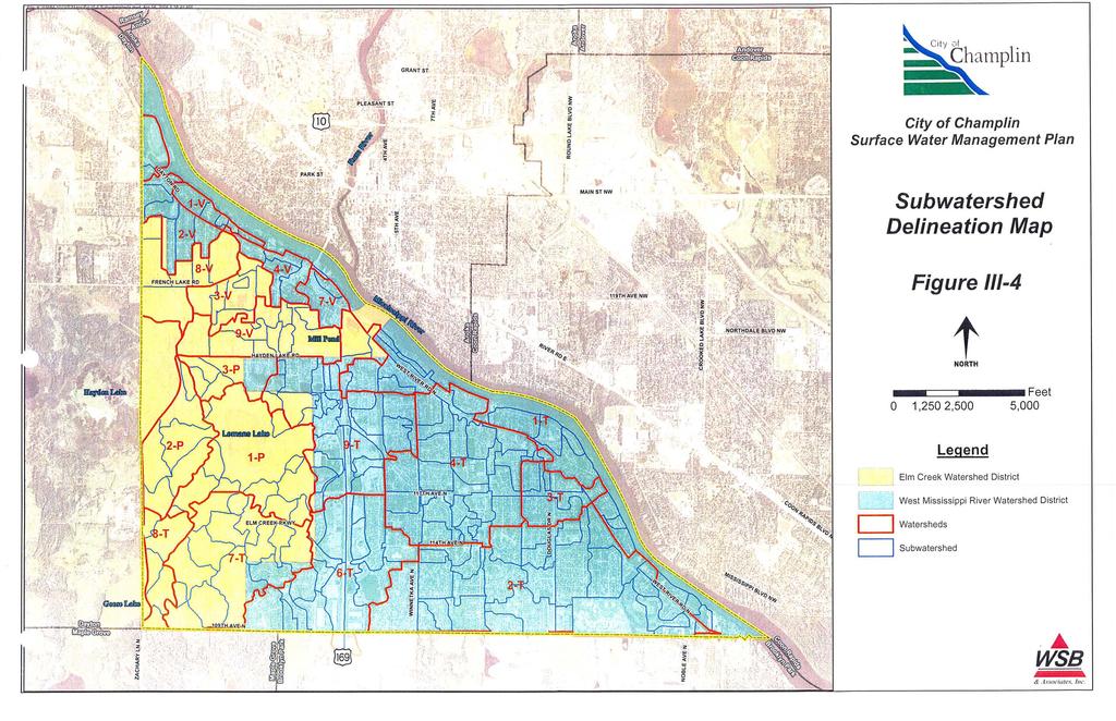
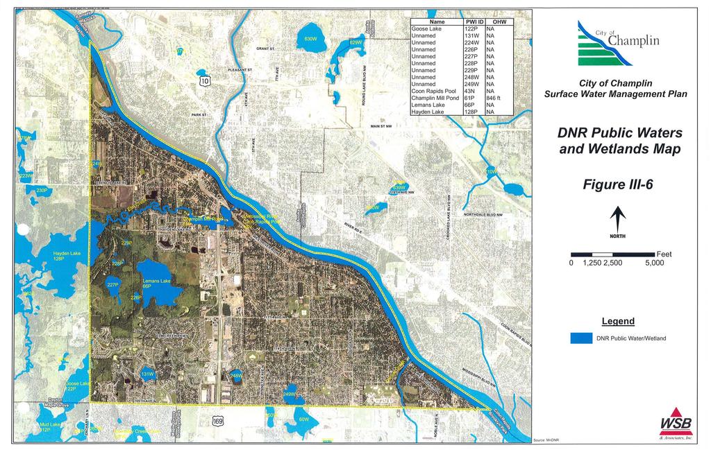
18 SECTION III 2. Topography: The southwestern portion of Champlin can be described as gently rolling with large depressions containing wetlands, the largest of which is Lemans Lake. The southwestern portion of the City is characterized by a rolling topography with scattered depressions containing various types of water features. From the northwest to the southeast, the topography is relatively flat, with a notable exception being the bluffs overlooking the Mississippi River. The terrain is characteristic of a glacial outwash plain. Storm water runoff from the City is generally directed from higher elevations to depression areas, especially in the southwest portion of the City located in the Elm Creek Watershed. Here, the storm water drains either into Elm Creek via Mill Pond or Oak Creek via Leman s Lake, which then flows into the Mississippi River. The remainder of the City is within the West Mississippi River Watershed and storm water from this portion drains to the Mississippi River via Oxbow Creek, Oak Creek, or via storm sewers. The City of Champlin is mostly developed. The drainage patterns, which depict topography for areas within the City, are shown on the subwatershed delineation map referred to as Figure III-4. The City of Champlin can be divided into nine major subwatersheds. Additional information regarding watershed delineation studies within the City can be found in the following reports or studies: Elm Creek Watershed Management Plan. Shingle Creek and West Mississippi Watershed Commissions Management Plan. This information is available at the Engineering Department. C. Surface Water Resource Data Available surface water resource data within the City is summarized in this section. Detailed information has been included either in the appendices to this report or has been identified by reference and is available at the Engineering Department. The hydrologic system of the City consists of wetlands, lakes, streams, and major water bodies as outlined below. 1. Wetlands Wetlands are shown on the National Wetland Inventory Maps published by the US Fish and Wildlife Service. Wetlands and lakes are also shown City of Champlin WSB Project No Section III Page 7
19 SECTION III on the DNR Public Waters/Wetlands inventory map. This information is shown on Figure III-5 and III-6. The Single Creek/ West Mississippi Watershed Management Commission (SCWMWMC) completed an inventory and assessment of high quality reference wetlands to develop a Wetland Management Plan for the area. The reference wetland in Champlin is DNR Public Wetland 249W located along the southern border of the City with Brooklyn Park. The City will complete the wetland functional assessment of the remaining wetlands in In 1992 as part of the City s first generation Surface Water Management Plan, water bodies and wetlands were assessed based on their sensitivity to storm water input based on the wetland s type and vegetation. Management categories to address water quality issues were then developed. With the anticipated completion of a function and value assessment of the wetlands in 2009, the wetland categories for each wetland may change. The City s wetland management strategies are outlined in Section V. 2. Major Bodies of Water There are several major water bodies that convey and store water within and through the City. These water bodies include: Mississippi River and associated wetlands: The River is the northeastern border of the City. Recreational activities include boating and fishing on the River. The River corridor also provides wildlife habitat for the area. Lemans Lake: Lemans Lake is within the Elm Creek Park Reserve owned by Three Rivers Park District. The area provides wildlife habitat. This Lake is classified as a Class IIII for Wildlife and Interpretation. Mill Pond: Mill Pond is associated with Elm Creek. Trails are located adjacent to Mill Pond for passive recreation activity. Elm Creek and associated wetlands: Champlin is the last community that Elm Creek flows through prior to discharging to the Mississippi River. Areas around the creek are publically and privately owned. This water body is classified as a Class IIII for Wildlife and Interpretation. Oxbow Creek and associated wetlands: Oxbow Creek is within Oxbow Park. The area provides habitat and trails for passive recreation of the Creek. City of Champlin WSB Project No Section III Page 8
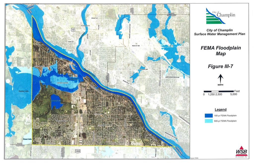
20 SECTION III 3. Water Quantity Inventory and Modeling The City s hydrologic/hydraulic system consists of ponds, wetlands, and storm sewer pipe systems within multiple subwatersheds that drain towards the Mississippi. The City is divided into approximately nine larger subwatershed areas, which are shown on Figure III-4. The watershed inventory and hydrological modeling information is available in Appendix B. Additional information regarding water quantity within the City can be found in the following studies: Northwest Area Infrastructure Analysis, 2002 Northwest Area Feasibility Study, Landlocked Basins The City has a number landlocked areas. These include the following ponds or subwatersheds are shown on Figure III-4. 8T-P3.3 5T-3 4T-29 2T-P16 2T-P17 2T-P21 2T-P20 DNR 22W (8V-P4.1) 8V-P3 9T-6: The structure at 4.1 has a pumped outlet that needs to be re-designed. 1T-P10. The City will evaluate these areas. If there are no flooding concerns, no outlet is necessarily needed and this area likely provides infiltration of storm water. If the area does flood or causes other problems, the City will study the feasibility of providing an outlet for the area. This process is further described in the implementation portion of this Plan. D. Flood Insurance Studies A Federal Emergency Management Agency (FEMA) Flood Insurance Study (FIS) was completed for areas within the City in 1977 and updated in The Flood Insurance Study consisted of a study report, a set of floodway and floodplain delineation maps, and a set of Flood Insurance Rate Maps (FIRM) maps. This study provides the basis for floodplain management regulations and is included in Appendix C. The floodplain boundaries for the City are shown in Figure III-7. Copies of publications containing flood insurance information are available at the Engineering Department. City of Champlin WSB Project No Section III Page 9
21 SECTION III E. Water Resource Problem Areas A number of water resource problems have been identified within the City in recent history. The problem areas were identified through information obtained from City Staff and from the public input process. Each site was investigated, background information collected, and potential solutions to address the problems were developed. These problem areas are shown on Figure III-8 and described below: Area 1: Donie Galloway Park within subwatershed 4P-2 occasionally floods. The City will investigate the feasibility of improving drainage within this Park. However, this area may be suitable to provide flood storage. This will be investigated as part of the review of this area. Area 2: Subwatershed 1-V is fully developed and within minimal existing or future opportunities for storm water treatment. As areas re-develop or street reconstruction occurs, opportunities to provide treatment will be investigated. Area 3: The storm sewer outlet for subwatershed 9T-6 is a pumped outlet that does not always meet the needs of the subwatershed. Area 4: The water quality of Mill Pond has been noted as a concern by the ECWMC. Area 5: The water quality of Lehmans has been noted as a concern by the ECWMC. Area 6: The water quality of Elm Creek has been noted as a concern by the ECWMC. Area 7: The water quality of the Mississippi River has been noted as a concern. Area 8: There are erosion concerns at the Oak Creek outlet. Area 9: Storm water discharge from the City of Brooklyn Park at 109 th Avenue enters a wetland complex in Champlin. Champlin residents have experienced wet basements in this area. While a studied was completed in 2000 by Brooklyn Park, this issue has not been resolved. More detailed information about these issues is available in Section IV of this Plan. City of Champlin WSB Project No Section III Page 10
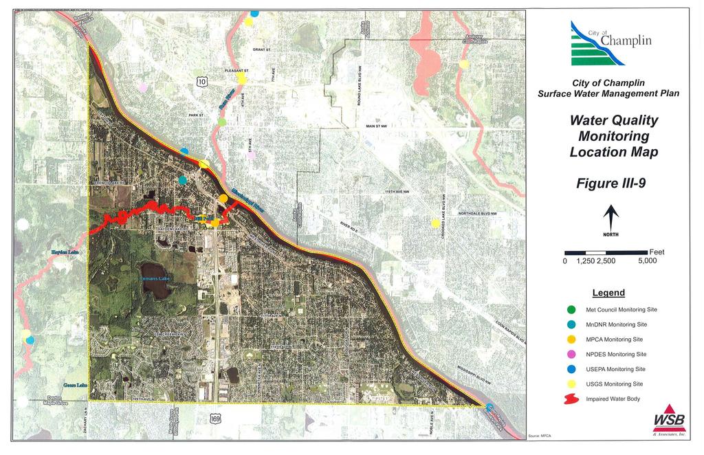
22 SECTION III F. Water Quality Data and Impaired Waters Water quality data for the City can be obtained from the MPCA s Environmental Data Access site at This database is utilized by participating agencies to compile water quality testing data and is almost entirely used for the storage of water quality parameters. Figure III-9 shows the location of monitoring sites listed on the MPCA web-site. Elm Creek and the Mississippi River are listed as impaired waters within the City for the following factors. Elm Creek dissolved oxygen Mississippi River mercury, PCB s, and fecal coliform Shingle Creek is also listed as impaired and is within the SCWMRWMC. However, the City of Champlin does not discharge water to Shingle Creek. A Total Maximum Daily Load (TMDL) study has been completed for Shingle Creek. G. Floodplain Management The City has adopted Floodplain Management Regulations to reduce risk to public health, property, and general welfare. A copy of these regulations can be found on the City s web-site at and in Appendix D. These regulations prohibit uses or activities within the floodplain or floodway that include structures or fill or that obstruct flood flows or cause increased flood elevations. H. Shoreland Management Since the City is fully developed, there is no Shoreland Management Ordinance. This has been added as an implementation component of this Plan. Figure III-6 shows the location of DNR Public Waters/Wetlands as well as the Ordinary High Water (OHW) level, if applicable. I. Ground Water Resource Data Within the City, municipal wells serve the City s water needs. Each of these wells has a ground water appropriation permit from the DNR. Figure III-10 shows the locations of the DNR permitted ground water appropriation sites within the City. Information from the SCWMWMC contains information about groundwater quality within the City of Champlin as follows: City of Champlin WSB Project No Section III Page 11
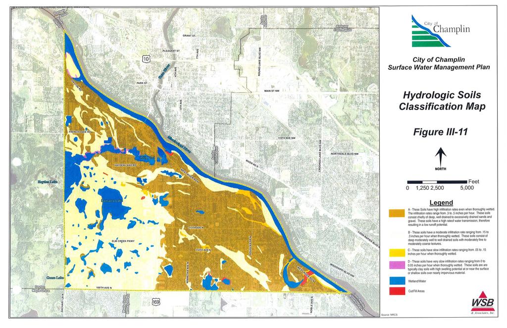
23 SECTION III GWMAP Number/ depth (feet) 01201/ / / / / Aquifer Aquifer Group Chloride (mg/l) Manganese (mg/l) Nitrate (mg/l) Iron (mg/l) Drinking Water Standard Water Surficial < table Quaternary Jordan Cambrian < Buried artesian aquifer Buried Quaternary Franconia Cambrian < Mount Simon Cambrian < Additional ground water resource data for areas within the City is available by reviewing the content of two reports as outlined below: Hennepin County Comprehensive Ground Water Plan, completed in March 1994, contains information about groundwater within the County. This Plan has not been adopted. Hennepin County Geologic Atlas, completed in 1989, contains information on aquifers, depth to groundwater table, and areas sensitive to groundwater pollution. J. Soils Information The hydrologic soil classification map on Figure III-11 shows the distribution of soils based on soil consistency and infiltration rates. The soils for the City of Champlin have been classified into four hydrologic soil groups which are defined as follows: Group A - These soils have high infiltration rates even when thoroughly wetted. The infiltration rates range from 0.3 to 0.5 inches per hour. These soils consist chiefly of deep, well-drained to excessively-drained sands and gravel. These soils have a high rate of water transmission, therefore resulting in a low runoff potential. Group B - These soils have moderate infiltration rates ranging from 0.15 to 0.30 inches per hour when thoroughly wetted. These soils consist of deep moderately well to well-drained soils with moderately fine to moderately coarse textures. Group C - These soils have slow infiltration rates ranging from 0.05 to 0.15 inches per hour when thoroughly wetted. These soils have moderately fine to fine texture. City of Champlin WSB Project No Section III Page 12
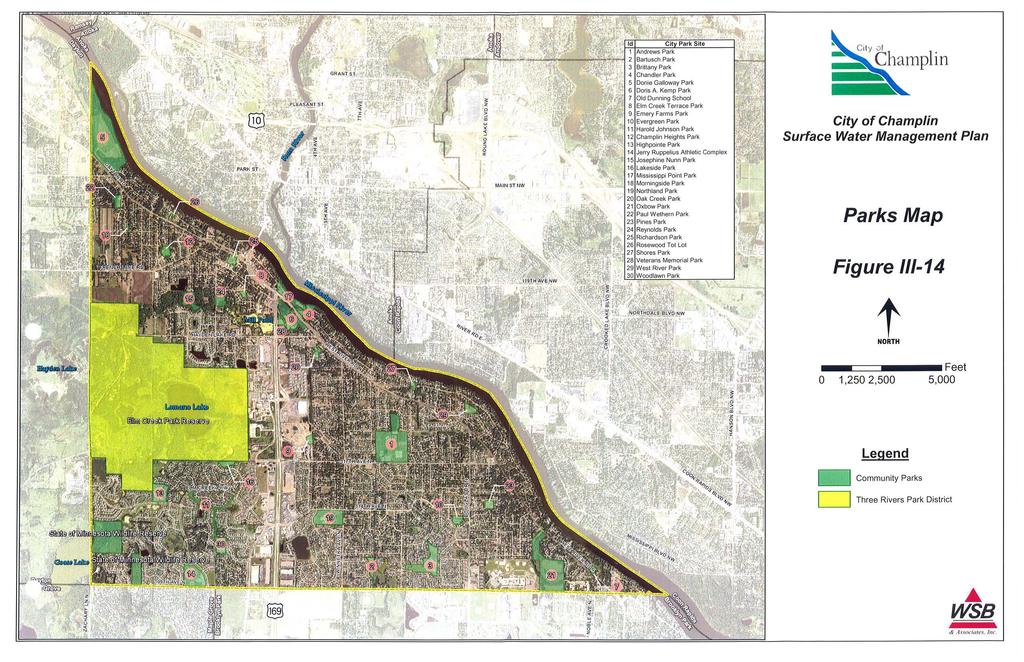
24 SECTION III Group D - These soils have very slow infiltration rates ranging from 0 to 0.05 inches per hour when thoroughly wetted. These soils are typically clay soils with high swelling potential, soils with high permanent water table, soils with a clay layer at or near the surface, or shallow soils over nearly impervious material. Cut/Fill Areas This is land where the native soil has been disturbed, covered, or removed for development. Additional information on the geology and soil for the City can be obtained from the Hennepin County Geologic Atlas and Hennepin County Soil Survey available at City Hall. K. Land Use and Land Cover The City of Champlin land use practices include residential, commercial, industrial, and public and private open space areas. Figure III-12 is a representation of the current land use districts for the City. The majority of the city is developed with residential, commercial and industrial land uses. The western one-third of the city, however, is predominantly park land (Elm Creek Park Preserve) with some remaining agricultural areas. The City is entirely within the MUSA area and most of the residences and businesses in the City are served by public water and sewer systems. An inventory of the existing land cover has been completed for the City of Champlin (see Figure III-13). The inventory utilized the Minnesota Land Cover Classification System (MLCCS). The MLCCS emphasizes vegetation land cover instead of land use, thus creating a land cover inventory that is particularly useful for open space planning, land use planning, conducting natural resource inventories, and identifying potential greenway corridors. L. Public Areas for Water Based Recreation and Access There are a number of water bodies that provide active recreation such as fishing and passive recreation such as walking and wildlife viewing. These recreational resources are outlined below: Mississippi River: The Mississippi River provides boating, fishing, and hiking opportunities within the City. The Mississippi River is also a State Canoe Route operated by the DNR Division of Trails and Waterways. Elm Creek Park Reserve: Elm Creek Park Reserve is partially within the City of Champlin. The park is managed by the Three Rivers Park District and contains many miles of trails and passive water-based recreation opportunities. Lemans Lake is within the Park. Elm Creek and associated wetlands: Champlin is the last community that Elm Creek flows through prior to discharging to the Mississippi River. City of Champlin WSB Project No Section III Page 13
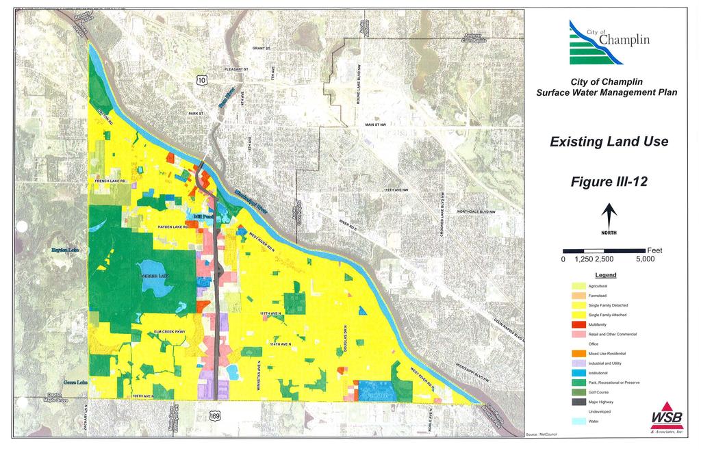
25 SECTION III Areas around the creek are publically and privately owned. There are some public trails near the Creek. Oxbow Creek and associated wetlands: Oxbow Creek is within Oxbow Park. The area provides habitat and trails for passive recreation of the Creek. Additional information regarding recreational opportunities within the City can be obtained by visiting the City of Champlin s Park and Recreation web site at Figure III-14 shows the locations of the City s parks. M. Fish and Wildlife Habitat Champlin provides habitat for a variety of small mammals, reptiles, birds, amphibians, and insects. These natural areas primarily include the areas around Lemans Lake, near the Elm Creek Park Reserve, and the Mississippi River floodplain. N. Unique Features and Scenic Areas Unique features and scenic areas include State designated Scientific and Natural Areas, designated scenic areas, areas containing rare and endangered species, and historic areas. The City contains no Scientific and Natural areas or designated scenic areas. Information from the DNR Natural Heritage Database shows that Blandings turtles have been noted near the Mill Pond area, Lehmans Lake, and Goose Lake. Information from the County Biological Survey shows areas of Oak Forest, mixed hardwood swamps, and wet meadow. These areas are primarily associated with the Elm Creek Park Reserve. Additionally, the City contains the Schmidt Wildlife Management Area as shown on Figure III-14. The Mississippi River is also part of the Mississippi National River Recreation Area (MNRAA) and the Mississippi River Critical Area. O. Pollutant Source Locations Information from the MPCA is shown on Figure III-15. This figure shows the approximate locations of a variety of pollutant sites. Many of the sites on the figure have been cleaned up or are in the process of being cleaned up. The MPCA should be contacted for site-specific details. P. NPDES Phase I The Minnesota Pollution Control Agency (MPCA) implemented the National Pollutant Discharge Elimination System (NPDES) Phase II Stormwater Program in March Phase II requires municipal separate storm sewer systems (MS4's) in urban areas with populations over 10,000 and under 100,000 to obtain an NPDES permit. Permits for construction sites greater than 1 acre will also be required as part of the Phase II. The City has submitted its Stormwater Pollution Prevention Plan and Notice of Intent in conformance with the MPCA guidelines. The intent of this Plan is to assist in implementation of the Phase I permit. City of Champlin WSB Project No Section III Page 14
26
27
28
29

30
31

32
33
34
35
36
37
38 SECTION IV IV. PROBLEMS AND CORRECTIVE ACTIONS Outlined below is an assessment of existing and potential water resource-related problems that are known at this time. These problems have been identified based on an analysis of the land and water resource data collected as part of this plan preparation and through information from the City. A description of any existing or potential problem within the topic area has been listed and future corrective actions have been incorporated into an implementation plan. A. Lake and stream water quality problems 1. The City discharges storm water to the following water bodies that have been listed as impaired by the Minnesota Pollution Control Agency (MPCA): Elm Creek dissolved oxygen Mississippi River mercury, PCB s, bacteria Lake Pepin Turbidity, eutrophication Corrective Actions: The City shall work with the Watershed Management Commission(s) and the Pollution Control Agency (PCA) to develop a Total Maximum Daily Load (TMDL) for the impaired waters within their boundaries. Once the TMDL report is complete for each water body and impairment, the City will complete a feasibility study to identify actions to be undertaken to address the TMDL. 2. The ECWMC has identified water quality concerns at Mill Pond, Elm Creek, and Lehmans Lake. Corrective Actions: The City will continue to require storm water treatment as part of development and redevelopment to address water quality concerns in Mill Pond, Elm Creek, and Lehmans Lake. Additionally, if funding becomes available, the City will work with the ECWMC to implement upstream water quality projects for Mill Pond and Elm Creek. Additionally, the City will work with the Three Rivers Park District if funding becomes available to implement upstream water quality improvements for Lehmans Lake. B. Flooding and storm water rate control concerns 1. Donie Galloway Park within subwatershed 4P-2 experiences occasional flooding. Corrective Actions: The City will investigate the feasibility of improving drainage within this Park. However, this area may be suitable to provide temporary flood storage. 2. The storm sewer outlet for subwatershed 9T-6 is a pumped outlet that does not always meet the needs of the subwatershed. Corrective Actions: The City will complete an analysis to address the pump capacity and subwatershed runoff for this outlet structure. It is anticipated reconstruction of this outlet structure is needed. City of Champlin Section IV - Page 1 WSB Project No
39 SECTION IV 3. The City has a number of landlocked basins or subwatersheds as follows: 8T-P3.3 5T-3 4T-29 2T-P16 2T-P17 2T-P21 2T-P20 8V-P4.1 8V-P3 9T-6 1T-P10 Corrective Actions: The City will evaluate each area. If there are no flooding concerns, no outlet would be necessary. If the area does flood or causes other problems, the City will study the feasibility of providing an outlet for this area. 4. There have been flooding and rate control concerns in the area north of 109 th Avenue where storm water from Brooklyn Park discharges to Champlin. Corrective Actions: The City will request that the SCWMWMC complete a feasibility study to address the flooding problem. C. Impacts of water quantity or quality management practices on recreational opportunities See Problem B.1. D. Impacts of storm water quality on fish and wildlife resources No concerns have been identified. E. Impacts of erosion and sedimentation on water resources 1. Erosion at the Oak Creek outlet has been noted as a concern. Corrective Actions: The City will undertake a channel stabilization project for the Oak Creek Channel. 2. There are old storm sewer outlets to the Mississippi River in various locations that are in need of maintenance or replacement. Corrective Actions: The City will review each outlet and conduct maintenance or upgrades as needed. F. Impact of land use practices and development on water resource issues 1. Most of the subwatersheds in the City are fully developed. These areas developed prior to the requirement to incorporate storm water management BMP s into the design and storm water runoff enters the river without treatment. Corrective Actions: When street reconstruction or redevelopment projects are proposed, the City will investigate additional BMP s that can be incorporated to provide pretreatment for storm water prior to discharge to the River. City of Champlin Section IV - Page 2 WSB Project No
40 SECTION IV G. Adequacy of existing regulations to address adverse impacts on water resources 1. The City is an MS4 community for the NPDES permit. Corrective Actions: The City has developed a Storm Water Pollution Prevention Plan (SWPPP) and submitted the permit in conformance with MPCA rules. 2. The City does not have a Shoreland Ordinance. Corrective Actions: The City will develop a Shoreland Ordinance when approached by DNR. 3. The City does not have a wetland ordinance. Corrective Actions: The City will conduct a functions and values assessment on its wetlands and develop a corresponding wetland ordinance. H. Identification of potential problems which are anticipated to occur in the next 20 years based on growth projections and planned urbanization. No issues have been identified. I. Availability and adequacy of existing technical information to manage water resources 1. The development of this Comprehensive Surface Water Management Plan has provided additional technical information to the City related to storm water management. Corrective Actions: The City will continue to update the hydrologic/hydraulic model and GIS database as new development and redevelopment occur. City of Champlin Section IV - Page 3 WSB Project No
41 SECTION V V. ESTABLISHMENT OF GOALS AND POLICIES The City has developed a number of goals, strategies, and policies for the management of storm water within the City. These goals and policies have been developed to complement county, regional, and state goals and policies and to assist the City in protecting valuable water resources. The goals of the City are as follows: Goals 1. To prevent flooding. 2. To reduce to the greatest practical extent the public capital expenditures needed to correct flooding and water quality problems. 3. To improve water quality. 4. To reduce erosion and sedimentation from surface flows. 5. To preserve wetlands, lakes, and streams. 6. To promote groundwater recharge. 7. To protect and enhance fish and wildlife habitat and water recreational opportunities. 8. To secure the other benefits associated with the proper management of surface water. In order to achieve the City s goals for managing storm water, four strategies were developed. These strategies will assist the City in targeting its main audiences for the purposes of storm water management as follows: Strategies Cooperation with other agencies: This strategy recognizes that the City is not alone in managing storm water within its boundaries. There are a number of other local, state, and federal agencies that also have rules and regulations related to storm water management. Through this strategy, the City has recognized these other agencies role in this endeavor and will cooperate and coordinate with these agencies as necessary. Education: This strategy includes educating various groups within the City about proper storm water management. Education of residents, City Staff, City Council, business owners, and developers is included in this strategy to assist in meeting the City s goals. Regulation: Much of storm water management comes in the form of regulations put on new or redevelopment within the City. These regulations will also assist the City in achieving their water management goals. Policies related to the management of storm water are included in the regulation strategy. Internal operations: The final strategy relates to the internal operations of the City. By outlining policies related to how the City s operations will treat and manage storm water, City of Champlin Section V Page 1 WSB Project No
42 SECTION V the City can work to achieve its storm water management goals. The City has identified target audiences for the policies outlined in each strategy. The target audiences and strategies are as follows: AUDIENCE Public Residents and Business Owners City Staff and City Council Developers Review Agencies STRATEGY Education, Regulation Cooperation, Education, Operation Education, Regulation Cooperation Based on the target audience and the strategy, the City has developed a number of policies. These policies are outlined below. A. COOPERATION WITH OTHER AGENCIES There are a number of other local, state, and federal agencies that have rules and regulations related to storm water management. Through this strategy, the City recognizes these other agencies role in this endeavor and will cooperate and coordinate with these agencies as necessary. This Plan is in conformance with but does not restate all other agency rules that are applicable to water quality and natural resource protection. The other agency rules and policies include rules, policies, and guidelines associated with the following organizations: Minnesota Department of Health Minnesota Pollution Control Agency Board of Water and Soil Resources and the Wetland Conservation Act Minnesota Department of Natural Resources US Army Corps of Engineers Minnesota Department of Agriculture US Fish and Wildlife Service West Mississippi Watershed Management Commission Elm Creek Watershed Management Commission While these other agency rules, policies, and guidelines are not all restated in this Plan, they are applicable to projects, programs, and planning within the City. The Minnesota Stormwater Manual, which is a document intended to be frequently updated, is incorporated by referenced into this Plan and can be found at City of Champlin Section V Page 2 WSB Project No
43 SECTION V Additionally, projects within the City will require review and permits from the Elm Creek Watershed Management Commission (ECWMC) or the Shingle Creek/West Mississippi Watershed Management Commission (SCWMWMC). Projects will be required to meet each WMC s requirements. The rules for these WMC s are contained in Appendix E and on each WMC s web-site. B. EDUCATION The purpose of the education strategy in meeting the City s goals is to foster responsible water quality management practices by educating residents, business owners, City Staff, City Council, and developers about proper storm water management. If these targeted audiences recognize their role in responsible storm water management in their homes, businesses, and practices, it is another means for the City to meet its goals. This education strategy has also been designed to be in conformance with the NPDES requirements. STRATEGY: EDUCATION Policy Policy No. 1 The City will continue to implement its public education as part of the NPDES Phase II program. 2 The City will develop and update its website for storm water management information, volunteer opportunities, public meeting notices related to storm water management, the City s SWPPP, and contact information for storm water issues. 3 The City will develop and distribute a quarterly newsletter and include information in other City mailings aimed at fostering responsible water quality management practices. Topics may include, but not be limited to: Wetland buffers Groundwater quality and protection Controlling invasive species Water conservation and the water cycle Proper hazardous waste disposal Yard waste management Pet waste disposal Illicit discharge 4 The City will collaborate with ECWMC, SCWMWMC, and other entities to implement storm water management education efforts. 5 The City will provide annual training opportunities to City Staff regarding housekeeping and construction BMPs and the NPDES permit requirements. 6 The City will conduct pre-construction meetings with contractors to review erosion control methods and inspections for projects that disturb one acre or more for City projects. City of Champlin Section V Page 3 WSB Project No
44 SECTION V 7 The City will submit a public notice 30 days in advance and hold an annual public meeting to review the SWPPP, Surface Water Management Plan, and BMPs. 8 The City will maintain a phone line and website link to report construction site erosion control concerns and waste disposal infractions. The phone number is and the City s website is C. REGULATION The policies developed in this strategy outline specific storm water management elements that are required to be implemented through the development and/or permitting process. The regulation strategy is targeted at the public, developers, City Staff, and City Council. Additionally, projects within the City will require review and permits from the Elm Creek Watershed Management Commission (ECWMC) or the Shingle Creek/West Mississippi Watershed Management Commission (SCWMWMC). Projects will be required to meet each WMC s requirements. The rules for these WMC s are contained in Appendix E and on each WMC s web-site. The trigger for permit review/permit by the WMC s is outlined below: SCWMWMC Projects with 15 acres or more of single-family residential development Projects with five acres or more of other development Projects adjacent to a DNR Public Water/Wetland/ Watercourse Plans for any land development or site work within a 100- year floodplain Review is requested by City Projects that impact wetlands and require a permit via the Wetland Conservation Act ECWMC Projects with eight acres or more of residential development Projects with five acres or more with more than to units/acre Projects with one acre or more of commercial development Road projects that increase impervious surface by one acre or more Projects that impact wetland and require a permit via the Wetland Conservation Act City of Champlin Section V Page 4 WSB Project No
45 SECTION V STRATEGY: REGULATION No. Rate Control Policy 1 Future discharge rates from new development and redevelopment will not exceed existing discharge rates for the 2-year, 10-year, and 100-year critical storm events. 2 Design calculations for the 2-, 10-, and 100-year critical storm event must be submitted to the City for review and approval. 3 The design of major storm water storage facilities shall accommodate a 100- year critical duration event. 4 The design of new local storm sewer systems shall be based on a 10-year critical duration rainfall event. 5 For collection systems not designed to meet rate control standards (i.e. catch basins) a clogging factor of 50% will be utilized in sizing intake structures. 6 No orifice having a diameter less than 8 is allowed in the design of rate control structures within the City. If a structure having an opening less than 8 is required to meet rate control requirements, the requirement will be increased to allow a rate consistent with an opening of this size. 7 An emergency spillway (emergency outlet) from ponding areas shall be installed a minimum of 1 foot below the lowest building opening and shall be designed to have a capacity to overflow water at an elevation below the lowest building opening at a rate not less than 3 times the 100-year peak discharge rate from the basin or the anticipated 100-year peak inflow rate to the basin, whichever is higher. Flood Control 8 The basement floor elevation will be 1 foot above the elevation of any known historic high groundwater elevations for the area and the 100-year high surface water elevation in the area. Information on historic high groundwater elevations can be derived from any reasonable sources including piezometer data, soil boring data, percolation testing logs, etc. City of Champlin Section V Page 5 WSB Project No
46 SECTION V 9 Any new development or redevelopment building construction within the City will maintain a minimum building opening elevation 3 feet above the projected 100-year high water elevation for the area. If this 3 foot building opening freeboard requirement is considered a hardship, the standard could be lowered to 2 feet if the following can be demonstrated: That, within the 2-foot freeboard area, storm water storage is available which is equal to or exceeds 50% of the storm water storage currently available in the basin below the 100-year elevation. That a 25% obstruction of the basin outlet over a 24 hour period would not result in more than 1 foot of additional bounce in the basin. An adequate overflow route from the basin is available that will provide assurance that one foot of freeboard will be maintained for the proposed low building opening. 10 For areas with landlocked basin, the area shall be modeled to accommodate a back-to-back 100-year, 24-hour rainfall event; and the 100-year, 10-day runoff event. The highest water elevation in the basin from this analysis shall be the 100-year high-water level. 11 The City prohibits filling activities within the 100-year floodplain that will cause an increase in the stage of the 100-year or regional flood or cause an increase in the flood damages in the reach affected unless floodplain mitigation at a 1:1 ratio is provided. Additional detail is provided in the City s floodplain ordinance on the City s web-site at 12 A plan review and permit is required for any project that is within the 100-year floodplain, upland flood storage area, or changes the timing, storage, or carrying capacity of any tributaries in the 100-year floodplain. 13 Any 100-year floodplain area on private property will be covered by a drainage and utility easement or outlot dedicated to the City upon development or redevelopment. Water Quality Treatment 14 Storm water must be treated prior to discharge to remove 60% of phosphorus and 85% of total suspended solids. Treatment can be provided in on-site or regional systems and through permanent ponding or a combination of BMP s that will meet these requirements. City of Champlin Section V Page 6 WSB Project No
47 SECTION V 15 If a permanent water quality pond is used to meet water quality requirements, the pond is required to meet the following requirements: Permanent pool depth of 4 to 10 feet 3:1 pool length to width ratio or greater with an irregularly shaped shoreline 10:1 side slopes for a 10-foot bench at the normal water elevation 3:1 to 20:1 side slopes for the remainder of the pond Skimming device designed to prevent migration of floatables and oils for at least the 2-year event Maintenance areas allowing access to remove sediment Permanent pool volume greater than or equal to 2.5-inch rainfall over the watershed assuming full development A 10 foot buffer comprised of mainly native plant species is required around storm ponds to provide additional water quality, minimize encroachment into the ponds, and reduce geese populations from access adjacent lawn areas. Seeding information for these buffers is contained in Appendix G. 16 New storm water management ponds that are constructed as part of private development shall be covered by drainage and utility easements or outlots that are dedicated to the City. Infiltration/ Volume Control 17 Storm water runoff abstraction via infiltration, evapotranspiration, capture, and/or reuse of storm water runoff is required in the amount equivalent to 0.5 inches of runoff generated by the new impervious surface. Runoff must be infiltrated within 48 hours. 18 Pretreatment of storm water is required prior to discharge to an infiltration system. 19 Infiltration will not be allowed in areas where the existing or past land uses have the potential to contaminate the storm water runoff, where the soils are not suitable for infiltration, or in areas where there is less than three feet of separation between the bottom of the infiltration system and the groundwater. 20 New development and redevelopment shall consider and incorporate to the extent practical and feasible Low Impact Development techniques that have been reviewed and approved by the City. A maintenance plan for these features will be submitted to the City for review and approval. City of Champlin Section V Page 7 WSB Project No
48 SECTION V Wetlands 21 The City designates the Elm Creek WMC and the West Mississippi WMC as the Local Government Unity (LGU) for the Wetland Conservation Act (WCA). 22 For new development or redevelopment projects, a minimum 20-foot/ average 30-foot buffer of native vegetation is required around wetlands and DNR Public Waters and Watercourses, excluding the Mississippi River. 23 A 50-foot buffer with native vegetation is required around Elm Creek for any new development. Redevelopment is required to attempt to accommodate this buffer as reasonable and practical. 24 Maintenance is allowed of an unimproved access strip through the buffer that is not more than 20 feet in width for recreational access to the wetland or water body. 25 Public trails are allowed within the buffer provided the total buffer width is maintained around the trail. 26 Management of noxious weeds or invasive species is allowed within the buffer. Planting of gardens or non-native species is not allowed within the buffer. 27 The City anticipates completing a wetland functions and values assessment using the most recent version of the Minnesota Routine Assessment Method (MnRAM). Based on the results of this assessment, the wetland management policies in Appendix F will apply. Groundwater 28 The City will cooperate with the Department of Health to insure that all unsealed or improperly abandoned wells within the City are properly sealed. 29 Infiltration areas will not be allowed within 400 feet of a community water well or within 100 feet of a private well or within a 1-year time of travel zone in a wellhead protection area. Erosion and Sediment Control 30 The City has an adopted erosion control ordinance that requires a permit for any land disturbing activity, including new home construction. Exemptions are outlined within the ordinance and include activities that result in less than 50 cubic yards of disturbance or filling. The City ordinance is included in Appendix D and on the City s website at 31 The City will conduct erosion control inspections in conformance with the NPDES permit for all projects that require an NPDES construction permit. City of Champlin Section V Page 8 WSB Project No
49 SECTION V D. INTERNAL OPERATIONS The City s internal operations can have a significant impact on storm water management. This strategy is targeted primarily at the City with some areas targeted at the public and/or another agency. These policies are aimed at operation and maintenance activities associated with water resource management within the City. STRATEGY: INTERNAL OPERATIONS No. Policy 1 The City will sweep the streets at least twice annually and record the results. Areas that need more frequent sweeping will be swept as needed. 2 The City will inspect 20% of its storm water treatment basins, structural pollution control devices, outfalls, and ponds every year on a rotating basis. Maintenance will be conducted as necessary. 3 Storm water runoff to a landlocked area that cannot handle the increased runoff must maintain runoff volumes to the existing conditions. 4 Outlets for landlocked areas will be allowed provided the outlet complies with wetland and floodplain regulations; the basin provides storage below the outlet for the back-toback 100-year, 24-hour event; and that there are no downstream impacts. 5 The City prefers to use regional detention and treatment areas rather than site specific detention areas where feasible. The City recognizes that development of these areas will likely be incorporated into development activity and may not be initiated independently by the City. If no regional system is available, development and redevelopment will be required to provide on-site systems. 6 The City requires as-builts of all ponding areas and designated emergency overflows. 7 The City will review its erosion control ordinance and make revisions as needed to address the SWPPP and other regulations as needed. Ordinances can be found in Appendix D and on the City s website at 8 The City will review and update its storm water management ordinance and floodplain ordinance as needed. Ordinances can be found in Appendix D and on the City s website at 9 The City will continue to enforce its illicit discharge ordinance. This illicit discharge ordinance can be found in Appendix D and on the City s website at 10 The City will maintain and update its storm sewer map, including storm sewer pipes, outfalls, ponds, conveyances, water bodies on an annual basis. 11 The City will annually conduct visual inspections of storm water discharges on Cityowned land and record results of inspections in conformance with the City s MS4 SWPPP. City of Champlin Section V Page 9 WSB Project No
50 SECTION V STRATEGY: INTERNAL OPERATIONS No. Policy 12 The City will contact the MPCA State Duty Officer at to report any hazardous material spills or discharges in conformance with the City s MS4 SWPPP. 13 The City will annually inspect and maintain any exposed stockpiles and storage areas on City property to prevent erosion and discharge into the storm sewer system or water body in conformance with the City s MS4 SWPPP. 14 The City will maintain and submit annual inspection reports, maintenance reports, and other needed documentation in conformance with the NPDES permit. 15 The City Staff will annually review and adjust as necessary mowing, fertilizing, and herbicide application practices to reduce organic and pollutant discharges to the storm sewer and water bodies. 16 The City will review road salt application practices and consider alternative products as they become available. 17 The City will cooperate with the MPCA and other outside organizations to develop Total Maximum Daily Load (TMDL) plans for the listed impaired waters that receive storm water from the City. The City will implement TMDL studies that affect land use within its borders as these studies are completed. City of Champlin Section V Page 10 WSB Project No
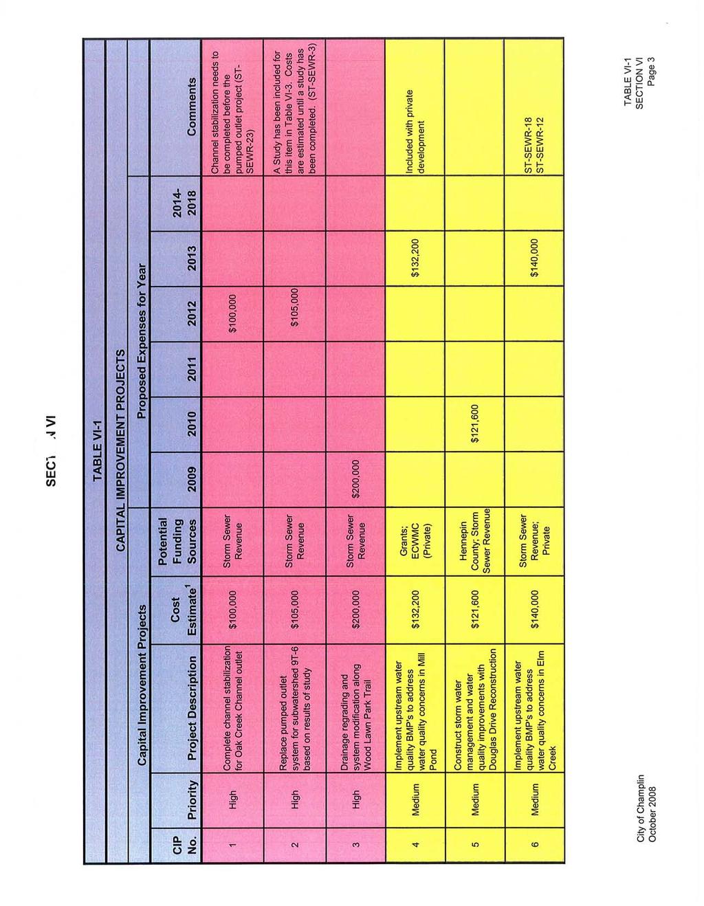
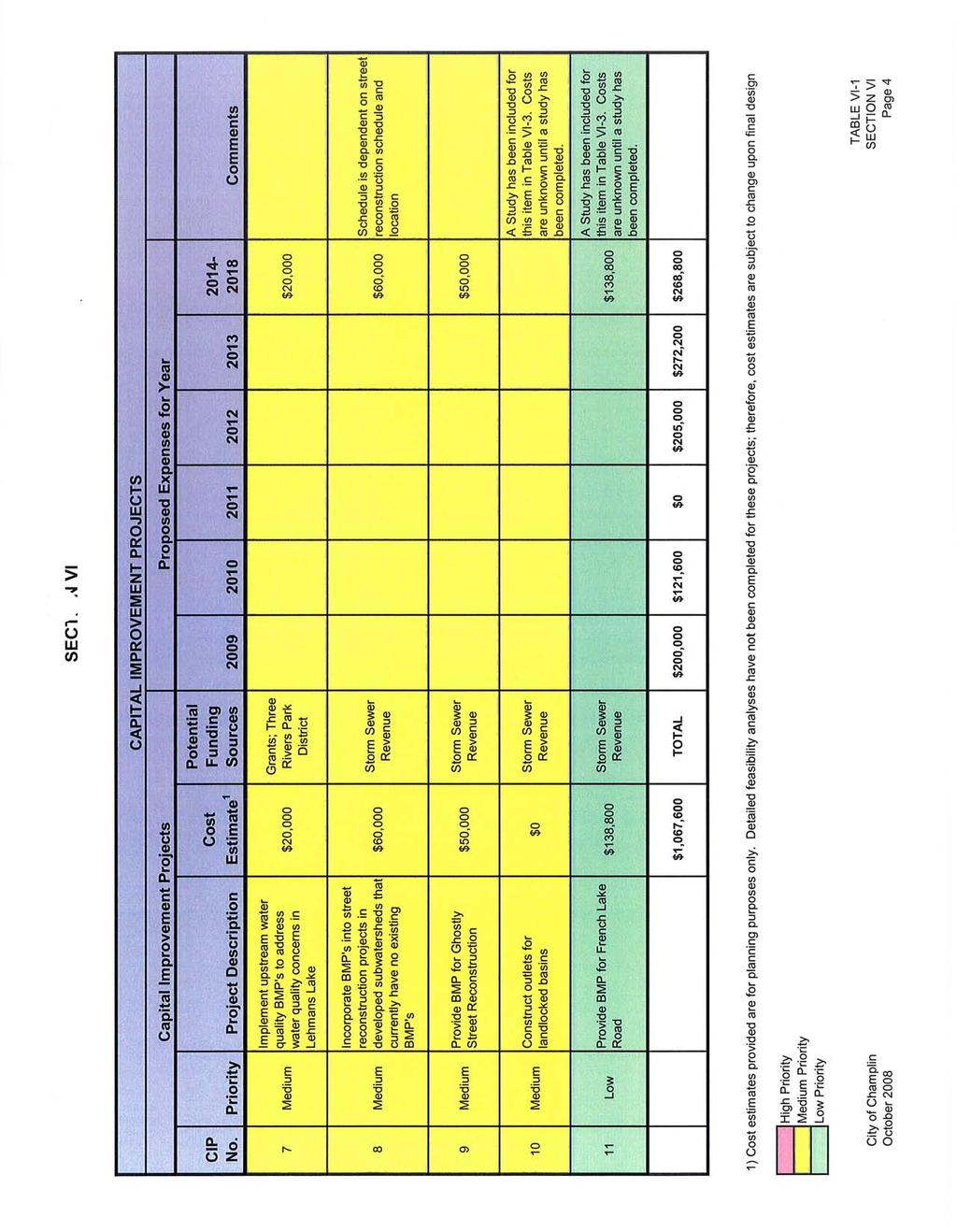
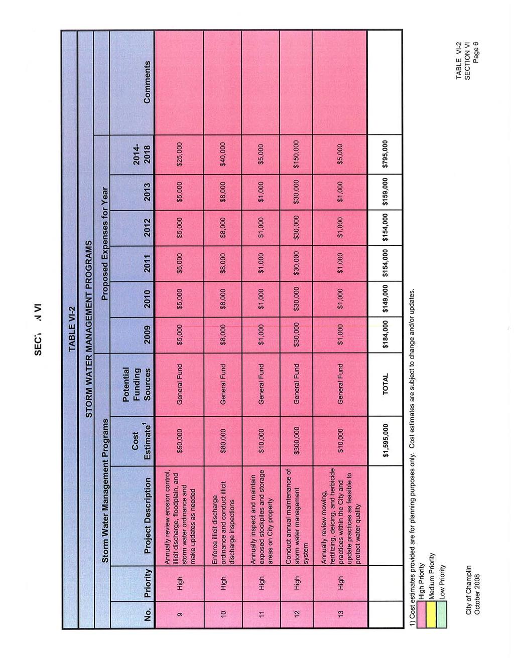
51 SECTION VI VI. IMPLEMENTATION PRIORITIES/ IMPLEMENTATION PROGRAM Based on the information developed in Sections III through V, the City has developed a Surface Water Management Plan that reflects the needs and concerns of the City Council, City Staff, citizens, and the funding capabilities of the City. A prioritized listing of the studies, programs and capital improvements that have been identified as necessary to respond to the water resource needs within the City is outlined on the following tables. The City anticipates implementing at least to some extent the regulatory programs, studies, or improvements identified in this plan within the next 10 years. The City has developed a method to prioritize Capital Improvement Projects. A three-tiered approach has been adopted that priorities projects as High, Medium, or Low. This method is based on the following criteria: High Priority: Projects meet one or more of the following criteria: Flood problem area that has structures inundated during events having intensities less than that associated with a 1% chance storm. Projects with the highest Benefit relative to Project Cost. Projects that should be completed soon to meet regulatory or permit requirements. Projects that are needed to address significant public safety concerns. Projects that are needed to finish or upgrade the construction of the City s storm water infrastructure system to meet long-term improvement plans. Projects that should be constructed now so as to be in conjunction with other projects that will result in a reduction in cost or impact to the public. Projects for which funding is now available or will be available in the next few years. Medium Priority: Projects meet one or more of the following criteria: Flood problem areas with structures that do not flood but have limited freeboard in less than 1% rainfall events and high potential for increased water elevations if system obstructions occur during the rainfall event. Projects with a high Benefit relative to Project Cost. Projects that must be completed soon, but not immediately to meet regulatory or permit requirements. Projects that are needed to address public safety concerns. City of Champlin Section VI Page 1 WSB Project No
52 SECTION VI Projects that are needed to finish or upgrade the construction of the City s storm water infrastructure system to meet long term improvement plans, but timing for construction should be delayed to accommodate other planning or project work. Projects that should be constructed soon and/or scheduled so as to be in conjunction with other projects that will result in a reduction in cost or impact to the public. Low Priority: These projects meet the criteria listed above, but are not urgent, have lower Benefit to Cost Ratios, can be delayed until other work can be done at the same time, or must be delayed until funds become available. Table VI-1 contains Storm Water Capital Improvement Projects (CIP), Table VI-2 contains Storm Water Management Programs (SMP), and Table VI-3 contains Storm Water Management Studies (SMS). Table VI-4 summarizes the information from all of these tables. The costs associated with these items reflect year 2008 costs and do not take into account inflation. These tables are for planning and budgeting purposes and are considered rough estimates. It is anticipated that these cost estimates will be reviewed annually and updated as needed. City of Champlin Section VI Page 2 WSB Project No
53
54

55
56
57
58
59
LOCAL SURFACE WATER MANAGEMENT PLAN FOR THE CITY OF CHAMPLIN, MINNESOTA. WORKING DRAFT October Prepared By:
 LOCAL SURFACE WATER MANAGEMENT PLAN FOR THE CITY OF CHAMPLIN, MINNESOTA WORKING DRAFT October 2018 Prepared By: WSB & Associates, Inc. 701 Xenia Avenue South, Suite 300 Minneapolis, MN 55416 763-541-4800
SECTION III LAND AND WATER RESOURCE INVENTORY
 III. LAND AND WATER RESOURCE INVENTORY In conformance with the Metropolitan Surface Water Management Act and as required in Minnesota Rules Section 8410.0060, this section of the plan provides a general
BCWMC 2015 Watershed Management Plan. Executive Summary
 BCMWC 2015 Watershed Management Plan Executive Summary Contents Executive Summary... ES-1 Section 1 Introduction... ES-1 Section 2 Land and Water Resource Inventory... ES-2 Section 3 Assessment of Issues
City of Fairmont Storm Water Pollution Prevention Plan (SWPPP) January 23, 2017
 January 23, 2017") City of Fairmont Storm Water Pollution Prevention Plan (SWPPP) January 23, 2017 Why is Water Quality Important? Water has always been important to Minnesota and is a key part of our history, culture, economy
City of Fairmont Storm Water Pollution Prevention Plan (SWPPP) January 23, 2017 Why is Water Quality Important? Water has always been important to Minnesota and is a key part of our history, culture, economy
C Fish Lake C Rice Lake C Mud Lake C Weaver Lake C Elm Creek*
 IV. PROBLEMS AND CORRECTIVE ACTIONS Outlined below is an assessment of existing and potential water resource-related issues that are known at this time. These issues have been identified based on Commission
City of Fairmont Storm Water Pollution Prevention Plan Annual Public Meeting. June 11, 2018
 City of Fairmont Storm Water Pollution Prevention Plan Annual Public Meeting June 11, 2018 Why is Water Quality Important? Water has always been important to Minnesota and is a key part of our history,
Surface Water Management
 Surface Water Management Figure 7: Examples of Nonpoint Source Pollution The water quality leaving the metropolitan area is as good as the water quality entering the metropolitan area, and in compliance
11. Public Utilities. Key Terminology: OVERVIEW STORMWATER MANAGEMENT WATERSHED MANAGEMENT ORGANIZATIONS AND COMMISSIONS. Inventory and Analysis
 Inventory and Analysis 11. Public Utilities Urbanized (drainage): Defined as an area where natural soils, waterways, and environmental functions are replaced with impervious surfaces (roads, parking lots,
Chapter 2: Conditions in the Spring Lake Watershed related to Stormwater Pollution
 Chapter 2: Conditions in the Spring Lake Watershed related to Stormwater Pollution To identify the primary causes and consequences of stormwater discharges to Spring Lake and its adjoining waterbodies,
South Washington Watershed District. Stormwater Pollution Prevention Plan (SWPPP)
") South Washington Watershed District Stormwater Pollution Prevention Plan (SWPPP) June 2008 1 I. Public Education and Outreach... 4 a) Distribute Educational Materials... 4 b) Education Implementation...
South Washington Watershed District Stormwater Pollution Prevention Plan (SWPPP) June 2008 1 I. Public Education and Outreach... 4 a) Distribute Educational Materials... 4 b) Education Implementation...
City of Duluth, the New UDC and Stormwater
 City of Duluth, the New UDC and Stormwater Tom Johnson, PE City of Duluth - Public Works Project Engineer, Utilities - Stormwater Stormwater Challenges Topography (proximity to lake) High Quality Streams
Environmental Resource Inventories. What are ERIs? Significance of information How to use them
 Environmental Resource Inventories What are ERIs? Significance of information How to use them Environmental Resource Inventory - ERI Compiled by the environmental commission Information about the natural
Municipal Stormwater Management Plan Prepared For The Borough of Cape May Point By Van Note-Harvey Associates VNH File No.
 Municipal Stormwater Management Plan Prepared For The Borough of Cape May Point By Van Note-Harvey Associates 2005 VNH File No. 35317-210-21 Table of Contents Introduction... 3 Goals... 3 Storm water Discussion...
City of Robbinsdale, Minnesota Storm Water Pollution Prevention Plan (SWPPP)
") City of Robbinsdale, Minnesota Storm Water Pollution Prevention Plan (SWPPP) 2006-2010 Adopted by City Council April 15, 2003 Amended for re-issuance of permit May 2006 Introduction The City of Robbinsdale
City of Robbinsdale, Minnesota Storm Water Pollution Prevention Plan (SWPPP) 2006-2010 Adopted by City Council April 15, 2003 Amended for re-issuance of permit May 2006 Introduction The City of Robbinsdale
CHAPTER 10: SURFACE WATER
 CHAPTER 10: SURFACE WATER 10.1 EXECUTIVE SUMMARY The City of Brooklyn Park, along with all other communities in the metropolitan area, must update their local water plan, as part of the comprehensive plan
IV. ENVIRONMENTAL IMPACT ANALYSIS G. HYDROLOGY/WATER QUALITY
 IV. ENVIRONMENTAL IMPACT ANALYSIS G. HYDROLOGY/WATER QUALITY ENVIRONMENTAL SETTING The project site is located in the Wilshire community of the City of Los Angeles and is bound by S. Wetherly Drive to
COON CREEK WATERSHED DISTRICT PERMIT REVIEW
 16-054 Woodland Creek Wetland Banking Restoration Project, Page 1 of 6 COON CREEK WATERSHED DISTRICT PERMIT REVIEW MEETING DATE: August 22, 2016 AGENDA NUMBER: 11 FILE NUMBER: 16-054 ITEM: Woodland Creek
APPENDIX H: SFEIS FLOODPLAIN IMPACT ANALYSIS SECTION
 TH 36/STH 64 St. Croix River Crossing 2005 Water Resources Preliminary Design Report APPENDIX H: SFEIS FLOODPLAIN IMPACT ANALYSIS SECTION within the project area. Other methods of attaining this reduction
COON CREEK WATERSHED DISTRICT PERMIT REVIEW. Spring Lake Park Schools Westwood Middle School st Avenue NE, Spring Lake Park, MN 55432
 PAN 16-112, Westwood Middle School, Page 1 of 6 COON CREEK WATERSHED DISTRICT PERMIT REVIEW MEETING DATE: August 22, 2016 AGENDA NUMBER: 10 FILE NUMBER: 16-112 ITEM: Westwood Middle School RECOMMENDATION:
3F. Hydrology and Water Quality
 This section provides an analysis of potential hydrological and water quality impacts associated with implementation of the proposed project. The section also evaluates and describes the potential impacts
New Castle County, DE. Floodplain Regulations
 New Castle County, DE Floodplain Regulations John J. Gysling, PE CFM Department of Land Use New Castle County, DE February 26, 2009 Today s Presentation Floodplain Protection and Uses Terms and Definitions
COON CREEK WATERSHED DISTRICT PERMIT REVIEW Mississippi Dr Coon Rapids, MN SQ FT Residence on 0.64 Acre Lot
 17-082 Van Sloun Residence, Page 1 of 5 COON CREEK WATERSHED DISTRICT PERMIT REVIEW MEETING DATE: May 8, 2017 AGENDA NUMBER: 17 FILE NUMBER: 17-082 ITEM: Van Sloun Residence RECOMMENDATION: Approve with
Final Report Section 319 and Clean Water Partnership Projects
 Grant Project Summary Final Report Section 319 and Clean Water Partnership Projects Project title: Wetland 639W Nutrient Export Reduction Organization (Grantee): Shingle Creek Watershed Management Commission
SECTION 3 NATURAL RESOURCES
 SECTION 3 NATURAL RESOURCES The natural environment plays a large role in planning for future development. Environmental conditions, such as topography, wetlands, floodplains, and water bodies, can often
Bluff Creek One Water
 Bluff Creek One Water The Bluff Creek Watershed has no lakes within its boundaries. As the westernmost watershed within the District, land use changes from agricultural to residential have occurred relatively
CHAPTER 10: SURFACE WATER MANAGEMENT
 CHAPTER 10: SURFACE WATER MANAGEMENT Chapter 10 includes the following information: 1. Introduction 2. Purpose of the Plan 3. Plan Development 4. Sustainability 5. Stormwater Management System 6. Water
CHAPTER 4 WATERSHED PLAN GOALS & OBJECTIVES
 4.0 Introduction CHAPTER 4 WATERSHED PLAN GOALS & OBJECTIVES After the watershed analysis had been completed, the next step in the planning process followed by the group was to come up with goals and objectives
WATER RESOURCES DRAFT 2040 CARVER COUNTY COMPREHENSIVE PLAN.
 WATER RESOURCES DRAFT 2040 CARVER COUNTY COMPREHENSIVE PLAN www.co.carver.mn.us/2040plan 5. WATER RESOURCES PLAN Introduction The Water Resources Section of the 2040 Comprehensive Plan is intended to meet
SECTION 10: WETLANDS PROTECTION
 SECTION 10: WETLANDS PROTECTION 10-1 INTENT AND PURPOSE A. Intent 1. The City finds that wetlands serve a variety of beneficial functions. Wetlands maintain water quality, reduce flooding and erosion,
CHAPTER 10: SURFACE WATER MANAGEMENT
 CHAPTER 10: SURFACE WATER MANAGEMENT Chapter 10 includes the following information: 1. Introduction 2. Purpose of the Plan 3. Plan Development 4. Sustainability 5. Stormwater Management System 6. Water
INDIAN CREEK WATERSHED PLAN EXECUTIVE SUMMARY
 INDIAN CREEK WATERSHED PLAN EXECUTIVE SUMMARY The Indian Creek Watershed covers a 38 square mile area in southern Lake County, Illinois that drains 24,116 acres before discharging into the Des Plaines
Municipal Stormwater Management Planning
 Municipal Stormwater Management Planning Christopher C. Obropta, Ph.D., P.E. Water Resources Extension Specialist with Rutgers Cooperative Extension Assistant Professor with Department of Environmental
Memorandum. Creekside Woods I & II Plymouth, MN BCWMC Summary: General Background & Comments. Floodplain
 Memorandum To: Bassett Creek Watershed Management Commission BCWMC June 15, 2017 Meeting Agenda Project: 23270051 2017 2128 4F Creekside Woods I & II Plymouth, MN BCWMC 2017-21 Summary: Proposed Work:
Phase II: Proposed (regulated) Impervious in disturbed area (ac) Long Lake Existing Impervious in disturbed area (ac)
 Impervious in disturbed area (ac) Long Lake Existing Impervious in disturbed area (ac)") Permit Application No.: 17-181 Rules: Erosion Control, Wetland Protection, and Waterbody Crossings & Structures Applicant: Hennepin County Received: 4/27/17 Project: CSAH 112 Phase II Complete: 9/5/17
Permit Application No.: 17-181 Rules: Erosion Control, Wetland Protection, and Waterbody Crossings & Structures Applicant: Hennepin County Received: 4/27/17 Project: CSAH 112 Phase II Complete: 9/5/17
Deep River-Portage Burns Waterway Watershed 2015
 2.4 Soils Soil development is the product of the interaction of parent material, topography, climate, organisms and time. Understanding the types of soils that exist within a watershed and their characteristics
CHAPTER 4 - EROSION & SEDIMENT CONTROL AND STORMWATER MANAGEMENT ORDINANCE OF DUBUQUE COUNTY, IOWA. Adopted March 29, 2010.
 CHAPTER 4 - EROSION & SEDIMENT CONTROL AND STORMWATER MANAGEMENT ORDINANCE OF DUBUQUE COUNTY, IOWA Adopted March 29, 2010 Table of Contents Page Part 1 Introduction...3 4-1 Title..................3 4-2
Appendix D Monitoring Program
 Appendix D Monitoring Program [This page left intentionally blank.] Shingle Creek and West Mississippi Watershed Management Commissions Third Generation Watershed Management Plan Monitoring Program Minnesota
Will County Site Development Permit Submittal Checklist TAB 1 PROJECT OVERVIEW
 Applicant: Reviewer: Permit No.: The following tables contain a checklist of the requirements before a review for a Site Development Permit submittal will be accepted. Not all requirements pertain to every
TABLE OF CONTENTS. Table of Contents. Executive Summary. 1. Introduction Background Purpose 1-2
 TABLE OF CONTENTS Table of Contents Executive Summary i vi 1. Introduction 1-1 1.1 Background 1-1 1.2 Purpose 1-2 2. Land and Water Resource Inventory 2-1 2.1 Topography and Watersheds 2-1 2.2 Soils 2-1
Mn/DOT Outstate District SWPPP
 SWPPP Table of Contents Introduction......4 PUBLIC EDUCATION AND OUTREACH...5 Distribute Educational Materials...5 Implement an Education Program...6 Education Program: Public Education and Outreach...7
LAKE COUNTY HYDROLOGY DESIGN STANDARDS
 LAKE COUNTY HYDROLOGY DESIGN STANDARDS Lake County Department of Public Works Water Resources Division 255 N. Forbes Street Lakeport, CA 95453 (707)263-2341 Adopted June 22, 1999 These Standards provide
2016 Monitoring Report; Mississippi River Tributaries
 2016 Monitoring Report; Mississippi River Tributaries SWWD s East Mississippi watershed (Map 1) is named after the former East Mississippi Watershed Management Organization which managed the area prior
Shell Rock River Watershed: Water Plans
 Shell Rock River Watershed: Water Plans The Shell Rock River Watershed encompasses Freeborn County. Each county has developed a 10-year rotating comprehensive local water management plan (LWMP) in order
Black River Watershed Management Plan Plan
 Black River Watershed Management Plan Plan Final Report Part II: Appendices May 2010 This watershed management plan was prepared for the New York State Department of State Division of Coastal Resources
CHELTENHAM TOWNSHIP Chapter 290: WATERSHED STORMWATER MANAGEMENT Article IV: Stormwater Management
 CHELTENHAM TOWNSHIP Chapter 290: WATERSHED STORMWATER MANAGEMENT Article IV: Stormwater Management Online ECode Available on Cheltenham Township Website at: http://ecode360.com/14477578 For all regulated
Environmental Information Worksheet
 Environmental Information Worksheet Water System Owner (Attach additional sheets if necessary) Needs and Alternatives Provide a brief narrative that describes: Current drinking water system needs. Project
CHAPTER 7 PHYSICAL INVENTORY OF THE CITY
 CHAPTER 7 PHYSICAL INVENTORY OF THE CITY Chapter 7: Physical Inventory of the City 39 This page intentionally left blank. Chapter 7: Physical Inventory of the City 40 SECTION 1 PHYSICAL SETTING While communities
Chapter 10 Natural Environment
 Chapter 10 Natural Environment Existing Conditions The Natural Environment Element addresses the protection, conservation, preservation, and restoration of the natural resources the Bayview Ridge Subarea,
City of Valdosta Land Development Regulations
 Chapter 324 Section 324-1 Environmental Planning Criteria Protection of Groundwater Recharge Areas (A) Purpose and Intent. Pursuant to O.C.G.A. 12-2-8 and the Georgia Department of Natural Resources (DNR),
I. Welcome & Introductions WPAC History (Paul Racette, PEC)
") Poquessing Creek Watershed ACT 167 STORM WATER MANAGEMENT PLAN Public Hearing July 10, 2012 I. Welcome & Introductions ---------- WPAC History (Paul Racette, PEC) Primary WPAC Members: Bucks County: Bensalem
Poquessing Creek Watershed ACT 167 STORM WATER MANAGEMENT PLAN Public Hearing July 10, 2012 I. Welcome & Introductions ---------- WPAC History (Paul Racette, PEC) Primary WPAC Members: Bucks County: Bensalem
S r u face W a W ter Mana n ge g ment n P l P a l n Adopted April 13, 2009
 Surface Water Management Plan Woodland, MN Adopted April 13, 2009 SURFACE WATER MANAGEMENT PLAN For the CITY OF WOODLAND Bolton & Menk, Inc. Adopted April 13, 2009 I hereby certify that this plan, specification
COON CREEK WATERSHED DISTRICT PERMIT REVIEW th Ave NE Ham Lake, MN 55304
 18-151 Meyer Garage, Page 1 of 5 COON CREEK WATERSHED DISTRICT PERMIT REVIEW MEETING DATE: January 28, 2019 AGENDA NUMBER: 9 FILE NUMBER: 18-151 ITEM: Meyer Garage RECOMMENDATION: Approve with 2 Stipulations
CHAPTER 10: SURFACE WATER MANAGEMENT
 CHAPTER 10: SURFACE WATER MANAGEMENT Chapter 10 includes the following information: 1. Introduction 2. Purpose of the Plan 3. Plan Development 4. Sustainability 5. Stormwater Management System 6. Water
S5.C.1 Public Education and Outreach
 City of Ferndale 2018 Stormwater Management Program This document is formatted as a response to specific special conditions within the Western Washington Phase II Municipal Stormwater Permit (Permit) that
Washington State University Pullman Stormwater Management Program Plan 2017
 Washington State University Pullman Stormwater Management Program Plan 2017 The Washington State University (WSU) Pullman Stormwater Management Program (SWMP) Plan has six elements derived from the Eastern
FIGURES Figure 1 - Map of Areas with High Land Slope Figure 2 - Conceptual Model of the Area Groundwater Hydrostatigraphic Column Figure 3 - Map of
 TABLE OF CONTENTS I. PURPOSE OF PLAN... 1 II. EXECUTIVE SUMMARY... 2 A. Plan Purpose and Background... 2 B. General Content of Required Local Plans... 4 C. Summary of the Goals, Problems, and Potential
Surface Water Management Plan
 Surface Water Management Plan 2018 2027 Prepared for the City of Apple Valley October 2018 Surface Water Management Plan 2018-2027 Prepared for the City of Apple Valley October 2018 Barr Engineering Co.
Stormwater Erosion Control & Post-Construction Plans (Stormwater Quality Plans)
") Stormwater Erosion Control & Post-Construction Plans (Stormwater Quality Plans) Allen County Stormwater Plan Submittal Checklist The following items must be provided when applying for an Allen County Stormwater
Stormwater Erosion Control & Post-Construction Plans (Stormwater Quality Plans) Allen County Stormwater Plan Submittal Checklist The following items must be provided when applying for an Allen County Stormwater
Public Notice ISSUED: 5/6/2014 EXPIRES: 6/5/2014
 APPLICANT: Kinghorn Company / Scannell Properties Public Notice ISSUED: 5/6/2014 EXPIRES: 6/5/2014 REFER TO: 2014-00724-MMJ SECTION:404 - Clean Water Act 1. APPLICATION FOR PERMIT TO discharge fill material
Final TMDL Implementation Plan. Prepared for Minnesota Pollution Control Agency
 Wirth Lake Final TMDL Implementation Plan Prepared for Minnesota Pollution Control Agency September 2010 4700 West 77 th Street Minneapolis, MN 55435-4803 Phone: (952) 832-2600 Fax: (952) 832-2601 wq-iw11-03c
UMD Storm Water Program Construction Requirements. Greg Archer, MBA Environmental Compliance Specialist
 UMD Storm Water Program Construction Requirements Greg Archer, MBA Environmental Compliance Specialist Phase 2 Regulatory Overview Dec. 1999 EPA issues Phase 2 Federal Register Municipalities (MS4) from
COON CREEK WATERSHED DISTRICT PERMIT REVIEW. KTJ 314, LLC Blaine, MN 55449
 18-118 ABRA Auto Body, Page 1 of 8 COON CREEK WATERSHED DISTRICT PERMIT REVIEW MEETING DATE: August 13, 2018 AGENDA NUMBER: 14 FILE NUMBER: 18-118 ITEM: ABRA Auto Body RECOMMENDATION: Approve with 6 Stipulations
3.0 Regulatory Framework
 3.0 Regulatory Framework Various units of government are involved in regulating water resource related activities. For example: The Board of Water and Soil Resources (BWSR) oversees the state s watershed
FINDINGS OF FACT And CONCLUSIONS
 FINDINGS OF FACT And CONCLUSIONS SOUTHWEST RECONNECTION PROJECT Highway 61/101 Flood Mitigation State Project No. 1009-24 and State Aid Project No. 010-661-002 Prepared for: Carver County September 2013
CITY OF MERCER ISLAND 2017 STORMWATER MANAGEMENT PROGRAM (SWMP) PLAN
 PLAN") CITY OF MERCER ISLAND 2017 STORMWATER MANAGEMENT PROGRAM (SWMP) PLAN May, 2017 CITY OF MERCER ISLAND 2017 S T O R M W A T E R M A N A G E M E N T P R O G R A M ( S W M P ) P L A N May 2017 City of Mercer
CITY OF MERCER ISLAND 2017 STORMWATER MANAGEMENT PROGRAM (SWMP) PLAN May, 2017 CITY OF MERCER ISLAND 2017 S T O R M W A T E R M A N A G E M E N T P R O G R A M ( S W M P ) P L A N May 2017 City of Mercer
Cannon River One Watershed, One Plan. POLICY COMMITTEE MEETING January 10, 2018 Rice County Government Center Faribault, MN
 Cannon River One, One Plan POLICY COMMITTEE MEETING January 10, 2018 Rice County Government Center Faribault, MN TASK Task 1. Aggregate Existing Physical & Spatial Data 1A. Create project maps 1B. Meeting
ORDINANCE # 854. Stormwater Management / Operation and Maintenance Requirements
 ORDINANCE # 854 Stormwater Management / Operation and Maintenance Requirements Section 1. Purpose and Authority In accordance with the provisions of Chapters 98, 124, 126, 440, 444, and 446h of the General
WATERSHED. Maitland Valley. Report Card 201
 Maitland Valley WATERSHED Report Card 201 The Maitland Valley Conservation Authority has prepared this report card as a summary on the state of our forests, wetlands, surface water, and ground water resources.
Environmental Services
 Environmental Services 14 River Water Quality Summary for the Twin Cities Metropolitan Area This document is a summary of the 14 water quality of major rivers in the Twin Cities metropolitan area (metro
One Watershed, One Plan Plan Content Requirements
 One Watershed, One Plan Plan Content Requirements From the Board of Water and Soil Resources, State of Minnesota Version: 2.00 Effective Date: 03/28/2018 Approval: Board Decision #18-14 Policy Statement
Post-Development Stormwater Runoff Performance Standards
 Post-Development Stormwater Runoff Performance Standards December 9, 2014 Topics Why performance standards? What practices/requirements are in effect in other States? The Workgroup s preliminary and final
City of Albany, Oregon. Willamette Basin TMDL Implementation Plan
 City of Albany, Oregon Willamette Basin TMDL Implementation Plan July 1, 2013 - June 30, 2018 TABLE OF CONTENTS BACKGROUND... 1 LOCATION IN THE WATERSHED... 1 SCOPE AND SUMMARY OF TMDL IMPLEMENTATION PLAN...
COON CREEK WATERSHED DISTRICT PERMIT REVIEW th Lane NE East Bethel, MN 55005
 18-115 South Terrace Cove, Page 1 of 6 COON CREEK WATERSHED DISTRICT PERMIT REVIEW MEETING DATE: July 23, 2018 AGENDA NUMBER: 8 FILE NUMBER: 18-115 ITEM: South Terrace Cove RECOMMENDATION: Approve with
LOCAL SURFACE WATER MANAGEMENT PLAN FOR THE CITY OF HUTCHINSON, MINNESOTA. December Prepared By:
 111 Hassan reet SE Hutchinson MN 55350 (320) 587-5151 DECEMBER 2015 LOCAL SURFACE WATER MANAGEMENT PLAN WSB Project. 2702-000 701 Xenia nue South, Suite 300 Minneapolis, MN 55416 Tel: (763) 541-4800 Fax:
EXECUTIVE SUMMARY - REVISED
 EXECUTIVE SUMMARY REVISED INTRODUCTION The purpose of the Town of Salem Storm Water Management Plan is to develop recommendations and implementation strategies for addressing drainage problems and minimizing
BCWMC Capital Improvement Program (Approved with Minor Plan Amendment July 2017)
") BCWMC Capital Improvement Program 2019 2023 (Approved with Minor Plan Amendment July 2017) Project Name City Number 2016 2017 2018 2019 2020 2021 2022 2023 Totals Honeywell Pond Expansion, Main Stem Watershed
BCWMC Capital Improvement Program 2019 2023 (Approved with Minor Plan Amendment July 2017) Project Name City Number 2016 2017 2018 2019 2020 2021 2022 2023 Totals Honeywell Pond Expansion, Main Stem Watershed
Minneapolis Impound Lot Facility Improvements Minneapolis, MN BCWMC
 Memorandum BCWMC May 17, 2018 Meeting Agenda Project: 23270051 2017 2144 5C Minneapolis Impound Lot Facility Improvements Minneapolis, MN BCWMC 2017-37 Summary: Proposed Work: Temporary surcharge for new
Oshawa Creek Watershed Management Plan EXECUTIVE SUMMARY
 Oshawa Creek Watershed Management Plan EXECUTIVE SUMMARY The Central Lake Ontario Conservation Authority (CLOCA) has recognized the need to prepare comprehensive management strategies for all of its watersheds.
Appendix A Stormwater Site Plan Report Short Form
 Appendix A Stormwater Site Plan Report Short Form The Stormwater Site Plan Report Short Form may be used for projects that trigger only Minimum Requirements #1-#5. These projects typically fall within
DRAINAGE AND NATURAL AQUIFER GROUNDWATER RECHARGE ELEMENT
 Goal 7.0. To optimize integrated stormwater management in order to reduce damage and impacts from sea level rise and flooding, promotes recharge to the Surficial Aquifer System (SAS), improve and protect
2014 Whatcom County Stormwater Management Program
 2014 2014 Whatcom County Stormwater Management Program A component of the Western Washington Phase II Municipal Stormwater Permit Whatcom County Public Works Department Stormwater Division THIS PAGE INTENTIONALLY
Instructions for Notice of Ground Disturbance Form:
 Instructions for Notice of Ground Disturbance Form: Prior to beginning any ground disturbance activity or finalizing your storm water plan, submit a completed 2 page Notice of Ground Disturbance Form to
The Town of Chester Stormwater Mapping Report
 The Town of Chester Stormwater Mapping Report Prepared by the Warren County Soil & Water Conservation District December 2013 Table of Contents Introduction and Location 3 Stormwater Runoff 3 Assessment
Long Prairie River Watershed Restoration and Protection Strategies (WRAPS) Report Summary
 Report Summary") Long Prairie River Watershed Restoration and Protection Strategies (WRAPS) Report Summary Minnesota has adopted a watershed approach to address the state s 80 major watersheds (denoted by 8-digit hydrologic
Long Prairie River Watershed Restoration and Protection Strategies (WRAPS) Report Summary Minnesota has adopted a watershed approach to address the state s 80 major watersheds (denoted by 8-digit hydrologic
Chapter 12 Local Surface Water Management Plan
 Chapter 12, Local Surface Water Management Page 184 Chapter 12 Local Surface Water Management Plan 12.0 Introduction Purpose This chapter serves as an addendum to the City of Fridley s approved 2001 Local
DEKALB COUNTY STORMWATER MANAGEMENT PLAN PHASE 2
 DEKALB COUNTY STORMWATER MANAGEMENT PLAN PHASE 2 Introduction DeKalb County, Illinois, located approximately 50 miles west of Lake Michigan, is rectangular in shape, with a north/south dimension of 36
Mapping and Understanding YOUR LAKE S WATERSHED By: Tony Groves, Pam Tyning, and Tory Meyers Water Resources Group, Progressive AE
 By: Tony roves, Pam Tyning, and Tory Meyers Water Resources roup, Progressive A What is a Watershed? A watershed is the land area surrounding a lake from which water drains to the lake. The imaginary line
Appendix 10-A. Optional Recharge Volume Approach
 Appendix 10-A Optional Recharge Volume Approach Table of Contents APPENDIX SECTION HEADINGS 10-A.0 INTRODUCTION 10-A-2 10-A.1 Horsely Method for Determining Recharge Volumes 10-A-2 10-A.1.1 Basis for Determining
Minnesota EAW Supplement
 Appendix I: Minnesota EAW Supplement Lower Pool 2 Channel Management Study: Boulanger Bend to Lock and Dam No. 2 Minnesota EAW Item Identification A supplement prepared for the Minnesota DNR to identify
Appendix B Stormwater Site Plan Submittal Requirements Checklist
 Stormwater Site Plan Submittal Requirements Checklist The Submittal Requirements Checklist is intended to aid the design engineer in preparing a Stormwater Site Plan. All items included in the following
EXECUTIVE SUMMARY DES PLAINES RIVER WATERSHED-BASED PLAN WHY A WATERSHED-BASED PLAN? WHAT IS A WATERSHED?
 Des Plaines River Watershed-Based Plan EXECUTIVE SUMMARY June 2018 EXECUTIVE SUMMARY DES PLAINES RIVER WATERSHED-BASED PLAN WHY A WATERSHED-BASED PLAN? Water is elemental to our lives. Plants and animals,
CCSD#1 Stormwater Standards
 SECTION 5 STORMWATER MANAGEMENT PLAN This Section of the Stormwater Management Design Standards describes the methods and criteria necessary to integrate infiltration, water quality, and flow control stormwater
IV. ENVIRONMENTAL/NATURAL RESOURCES
 IV. ENVIRONMENTAL/NATURAL RESOURCES The City of East Bethel is one of the largest cities in Minnesota encompassing approximately 48 square miles. The landscape of the community is a gentle undulating plain
Public Notice ISSUED: 11 February 2019 EXPIRES: 13 March 2019
 SPONSOR: Minnesota Board of Water and Soil Resources Public Notice ISSUED: 11 February 2019 EXPIRES: 13 March 2019 REFER TO: MVP-2019-0122-JTB SECTION: 404 - Clean Water Act 1. WETLAND COMPENSATORY MITIGATION
MINNEHAHA CREEK WATERSHED DISTRICT BOARD OF MANAGERS REVISIONS PURSUANT TO MINNESOTA STATUTES 103D.341. Adopted April 24, 2014 Effective June 6, 2014
 MINNEHAHA CREEK WATERSHED DISTRICT BOARD OF MANAGERS REVISIONS PURSUANT TO MINNESOTA STATUTES 103D.341 Adopted April 24, 2014 Effective June 6, 2014 EROSION CONTROL RULE 1. POLICY. It is the policy of
CHAPTER 10 CRITICAL DRAINAGE AREAS
 CHAPTER 10 CRITICAL DRAINAGE AREAS Contents 10.0 INTRODUCTION 10-1 10.1 IDENTIFICATION OF CRITICAL DRAINAGE AREAS 10-1 10.1.1 Site Physical Attributes 10-2 10.1.2 Protection of Fish & Wildlife Habitat
The DNR is charged with managing waters resources to assure an adequate and sustainable supply for multiple uses.
 The DNR is charged with managing waters resources to assure an adequate and sustainable supply for multiple uses. Minnesota Laws 2015, chapter 4, article 4, directed the Department of Natural Resources
BCWMC Capital Improvement Program (approved April 19, 2018; pending minor Plan amendment)
") BCWMC Capital Improvement Program 2020 2024 (approved April 19, 2018; pending minor Plan amendment) Project Name City Number 2019 2020 2021 2022 2023 2024 2025 Totals Medicine Lake Rd and Winnetka Ave
BCWMC Capital Improvement Program 2020 2024 (approved April 19, 2018; pending minor Plan amendment) Project Name City Number 2019 2020 2021 2022 2023 2024 2025 Totals Medicine Lake Rd and Winnetka Ave
Water Quality Stewardship Plan (WaQSP)
") Salt Lake Countywide Water Quality Stewardship Plan (WaQSP) Natalie Rees Salt Lake County Flood Control & Engineering Division 2008 Watershed Symposium COUNTY RESPONSIBILITY AND AUTHORITY Salt Lake County
Salt Lake Countywide Water Quality Stewardship Plan (WaQSP) Natalie Rees Salt Lake County Flood Control & Engineering Division 2008 Watershed Symposium COUNTY RESPONSIBILITY AND AUTHORITY Salt Lake County