GROUNDWATER. Groundwater Allocation of the Alexandra Basin
|
|
|
- Rosa Curtis
- 6 years ago
- Views:
Transcription

1 GROUNDWATER Groundwater Allocation of the Alexandra Basin
2 Groundwater Allocation of the Alexandra Basin October 2005 Gabor Bekesi Senior Resource Scientist Groundwater
3 All rights reserved. This publication may not be reproduced or copied in any form, without the permission of the Otago Regional Council. This copyright extends to all forms of copying and any storage of material in any kind of information retrieval system.
4 i Chairman s foreword Groundwater Allocation in the Alexandra Basin Otago s prosperity is largely based on water. The Clutha River drains much of the Otago region and has the largest annual discharge of any river in New Zealand. However, despite the large total water volumes present in the region s water bodies, many areas of Otago are short of water. In many cases, irrigation particularly in these drier areas is critical to the continued well being of the people and communities who rely on the primary production it supports. The Regional Policy Statements for Water provides for the Otago people and communities having access to water for their present and reasonably foreseeable needs. Groundwater is frequently the sole or major source of water to supply basic water needs to communities and stock watering. Currently groundwater only supplies a small proportion of irrigation needs, however there is increasing pressure for people to turn to groundwater because surface water supplies are heavily allocated. Over abstraction can result in loss of supply to other users and therefore careful management is required to keep abstraction rates sustainable. Groundwater resources have varying rates of recharge and often form a complex dependency with adjacent water courses, wetlands and stream networks. The effects of inappropriate land and water use and development on groundwater quantity and quality are often long term, and in some cases permanent. It is therefore important that particular consideration be given to the protection of aquifers for the continuing benefit of present and future generations. Through the Regional Plan: Water and our Annual Plans we ensure linkage with the community to deliver the efficient use and protection of our groundwater aquifers. This report describes the potential for the future allocation of water from the Alexandra Basin Aquifer. It is based on local knowledge, scientific evidence and monitoring information. The best way forward is to use to advantage this valuable resource but to maintain control so that over abstraction does not occur. This is a complex topic and further monitoring and review of the aquifer will continue to ensure a sustainable allocation.
5 ii
6 iii Executive Summary This report summarises knowledge about groundwater in the Alexandra Basin and recommends further work focused on improving water allocation. Two main aquifers form the Alexandra Basin groundwater resource. The Alexandra Aquifer (Manuherikia Claybound, Dunstan Flats, and Manuherikia Alluvial subaquifers) forms the eastern part of the Alexandra Basin. Groundwater from the Manuherikia Claybound sub-aquifer flows into the Dunstan Flats and Manuherikia Alluvial sub-aquifers. Most of this groundwater is discharged to the Clutha River/Mata- Au. On the western side, groundwater from the Earnscleugh aquifer flows to the Clutha River/Mata-Au. Through the review of the information available for groundwater allocation, it became apparent that future groundwater allocation from the Manuherikia Claybound Aquifer must have regard to other sub-aquifers of the Alexandra Basin. Significant parts of the groundwater balance are uncertain; including how much groundwater is actually allocated. Complicating matters even further, large amounts of groundwater have been allocated for bores that may draw the majority of their water from the Clutha River/Mata-Au through groundwater-surface water interaction. A series of groundwater management options were considered which would allow the most effective use of the groundwater resource into the future. The current approach of allocating a maximum fixed rate, based on rainfall recharge, was only considered suitable for first order estimates in conditions such as those for semi-arid climates of the Otago region. The recommended approach for initial water allocation was for integrated water management, combining aspects of rainfall recharge and surface waters. For example, surface water allocation could be combined with up to 50% of rainfall recharge and water would be allocated regardless of origin. This is a simple and practical method that would initially suit most Central Otago catchments as surface and groundwater catchments appear to coincide. As more information becomes available through data collection and monitoring, a numerical groundwater model can be developed that can serve as a basis for long-term water allocation. Having such an adaptive method also allows it to be combined with other potential options such as maintaining groundwater levels, setting thresholds or localised hotspot elimination tools. These options can be designed to best fit local conditions. To gain maximum benefit from the groundwater resource it is essential that the components of the groundwater budget are monitored and analysed. As more information becomes available and the aquifers better understood, allocation can then be adapted to fit the relevant conditions.
7 iv
8 v Table of Contents Chairman s foreword Groundwater Allocation in the Alexandra Basin... i Executive Summary... iii 1. Introduction Groundwater-surface water interaction and allocation General Introduction Sustainability and water resources Hydrogeology Component aquifers: The Earnscleugh aquifer (after Mintago Investments Ltd, 1997) The Alexandra Aquifer Groundwater monitoring Current groundwater allocation Future groundwater allocation Groundwater budget for the Alexandra Basin Groundwater allocation for the Alexandra Aquifer future potential options Continue current approach The modified Lincoln approach Minimum groundwater levels to be maintained Setting thresholds for trends Hotspot elimination tools Safe yield or sustainable yield limits The need for monitoring and review of groundwater allocation Conclusions and recommendations References List of Tables Table 1 Major Water Resources of the Alexandra Basin and their relevance to groundwater... 2 Table 2 Alexandra Basin groundwater allocation Table 3 Groundwater budget in the Alexandra Basin List of Figures Figure 1. The Alexandra Basin Figure 2 Conceptual cross-section... 5 Figure 3. The Earnscleugh aquifer and the Fraser River.... 6
9 vi Figure 4 Mean groundwater levels for the period 1993 to Figure 5 Large increases or episodic recharge events (late 1995 and 1999) coincide with the largest rises in hydrograph (black curve) for bore P46A, Dunstan Flats sub-aquifer Figure 6 Groundwater level (black) at site P73A. Groundwater data courtesy of Contact Energy
10 1 1. Introduction This report provides a review of current and future potential groundwater allocation in the Alexandra basin. It includes a link between major water resources and groundwater and what is known about the hydrogeology of the area. Groundwater monitoring is also analysed and comparison of groundwater levels and river levels are made to show that there are important interactions between the two. The groundwater budget has been assessed and future potential options for groundwater allocation are discussed. The most suitable options for the semi-arid Alexandra basin are identified and a methodology for allocation in the near and more distant future is provided. 1.1 Groundwater-surface water interaction and allocation General Introduction Groundwater is not an isolated resource and interacts with surface water. In natural, pre-development conditions unconfined aquifers (such as the Earnscleugh and Alexandra aquifers) receive recharge from rainfall and surface water and discharge groundwater to surface water and via evaporation. Recharge and discharge are normally equal; the groundwater system is in equilibrium, over long time periods. When groundwater is used from unconfined aquifers connected to surface waters, groundwater levels decline and eventually a significant reduction in aquifer discharge to surface water occurs. Examples include reduced spring flow, reduced wetlands or decreasing stream network. Alternatively, extra recharge from surface water could occur (Bredehoeft, 1997). Natural discharge, from the aquifers into streams, springs, lakes, and wetlands (termed Groundwater Dependent Ecosystems) could decrease (Sophocleous, 1997) and, if pumping equals recharge, eventually groundwater dependent ecosystems could dry up. Groundwater therefore is normally allocated ensuring a minimum level of water is maintained in bores, or baseflow in surface water. Initially allocation is based on a back of the envelope type calculation but as water resources are developed, more information becomes available and water allocation becomes more sophisticated and complex. It is important therefore to understand existing information and to recognize shortcomings and gaps in knowledge. In the absence of adequate hydraulic data simple approaches can be used, such as those recommended by Lincoln Environmental (2001). Combined surface and groundwater allocation based on properly calibrated numerical models represent a more sophisticated allocation methodology. The trade-off is that a sophisticated allocation methodology requires more data and investment.
11 2 2. Sustainability and water resources The sustainability of groundwater occurs when pumping captures a proportion of the natural discharge without causing adverse effects on surface water or other groundwater dependent ecosystems. Therefore it is important to recognise what Groundwater Dependent Ecosystems are and their importance in the Alexandra Basin. An inventory of water resources, Table 1, in the Alexandra Basin indicates that: 1. The Clutha River/Mata-Au dominates the basin. Its annual mean flow is magnitudes larger than the sum of all other water resources of the basin. Water is available for allocation from the Clutha River/Mata-Au. 2. Other important surface water courses include the Fraser River and the Manuherikia River, and the Waikerikeri Creek. 3. Excess rainfall, or rainfall recharge to groundwater is a relatively small component of the water budget. Table 1 Major Water Resources of the Alexandra Basin and their relevance to groundwater Water Resource Mean annual Comments/values flux Ml/yr Clutha River/Mata-Au Artificially controlled, incised major river. Water is available for allocation. Used for power generation, recreational/fishery. All groundwater in the basin is assumed to discharge to the Clutha River/Mata-Au. Evidence of episodic recharge from the Clutha River/Mata-Au exists. Manuherikia River Surface water allocated above mean flow, trout/native fishery, recreational. Gains from groundwater but via irrigation schemes some irrigation losses are actually recharging groundwater. Fraser River ~ (Augmented by Lake Dunstan). Allocated, trout fishery/spawning. ~ Ml/yr could be lost to groundwater, and less than Ml/yr re-gained Excess rainfall Diffuse, episodic recharge to groundwater. Waikerikeri Creek Allocated, ~ Ml/yr lost to groundwater The Clutha River/Mata-Au is the major drainage of the Alexandra Aquifer (Figure 1). Since 1992 the river has been artificially controlled between the Clyde and Roxburgh dams (MWH 2002). The river bed was artificially lowered in the mid 1990s. Water is available for allocation from the river.

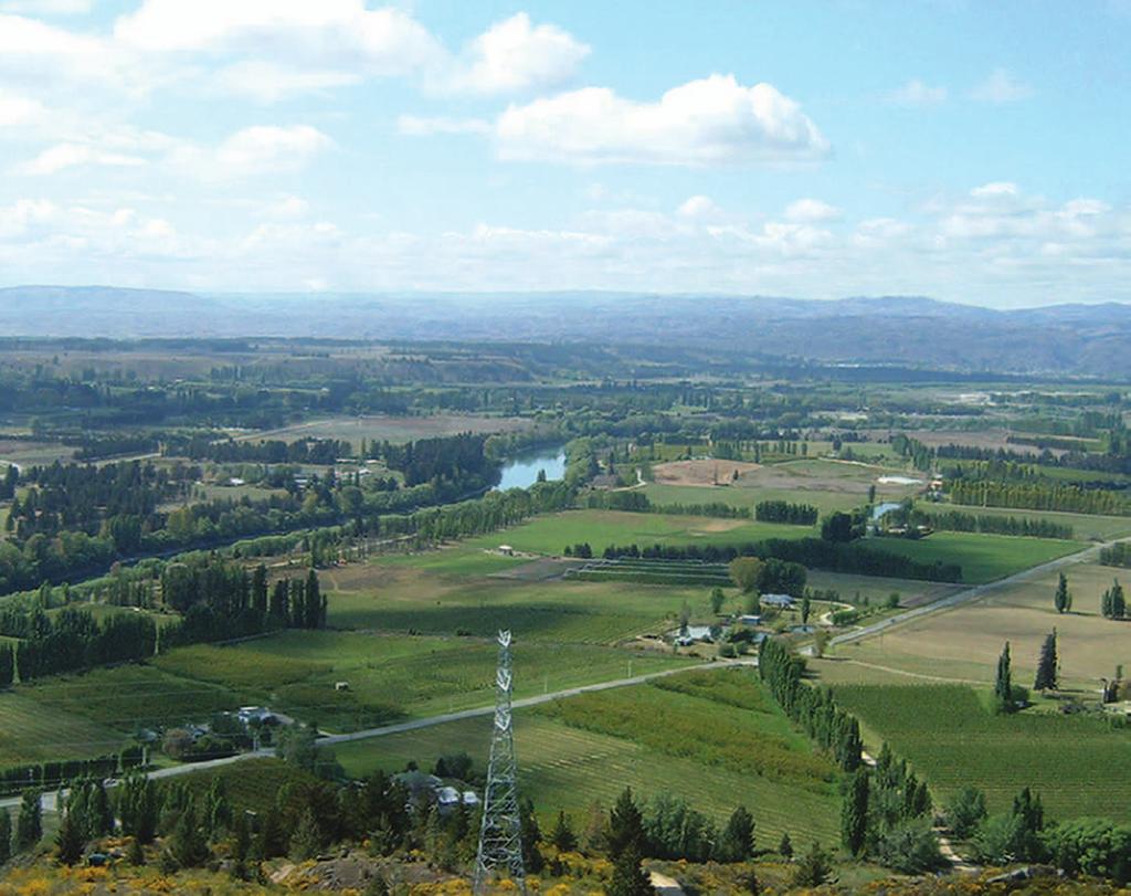
12 3 Manuherikia Claybound Aquifer Earnscleugh Earnscleugh Earnscleugh Earnscleugh Earnscleugh Earnscleugh Earnscleugh Earnscleugh Earnscleugh Terrace Terrace Terrace Terrace Terrace Terrace Terrace Terrace Terrace Aquifer Aquifer Aquifer Aquifer Aquifer Aquifer Aquifer Aquifer Aquifer Dunstan Flats Aquifer Manuherikia Alluvium Aquifer kilometers Figure 1. The Alexandra Basin. Red circles represent bores The Manuherikia River receives groundwater from the Manuherikia Alluvium subaquifer, as indicated by the groundwater potentiometric map (MWH 2004). Most of the river flow is redistributed by the Manuherikia, Galloway, and Springvale irrigation schemes. Irrigation channel losses and on-farm irrigation losses (irrigation return water) also recharge the Alexandra aquifer, but the amount of recharge from this source remains unknown. Various estimates of groundwater recharge from imported irrigation water include 3200 Ml/yr to Dunstan Flats sub-aquifer (MWH, 2002); Ml/yr irrigation return water from the Manuherikia Scheme (Irricon, 1998) mainly to the Dunstan Flats sub-aquifer. The Fraser River loses water to the underlying groundwater in the first four kilometres from the gorge to the Earnscleugh Road Bridge and gains some groundwater further downstream. Water from the Waikerikeri Creek is abstracted for irrigation in the upper reaches. The lower part of the creek receives some by-wash water from the Manuherikia Irrigation Scheme. The creek loses almost all of its flow to groundwater near Muttontown. This loss was estimated previously as 2016 Ml/yr (MWH 2002) and 2333 Ml/yr (MWH, 2004). The current ORC estimate of 1200 Ml/yr (Hickey, pers. comm., 2005) is used in this report because it is the best available estimate recognising that the Waikerikeri Creek is ephemeral. The deviation of these estimates indicates the large uncertainties involved in estimating groundwater-surface water interaction in this catchment.
13 4 3. Hydrogeology The climate of the Alexandra Basin is characterized by hot summers and cold winters and semi-arid conditions. Mean annual temperature is 10.6 ºC. Mean annual pan evaporation is just over 1000mm. The 350 mm mean annual rainfall is fairly evenly distributed, although average winter rainfall is lower than other seasons. Soil moisture deficit occurs, on average, between October-April. Only a small soil moisture excess, totalling on average 38 mm/year (MWH, 2002), for June-August, recharges groundwater from rainfall. Actual rainfall recharge to groundwater can vary enormously and episodic recharge (due to a single large rain or flood event) could be significant in these semi-arid or more precisely arid conditions. Therefore rainfall recharge would be more appropriately considered as 380mm per 10 years on average to reflect the long-term recharge rate and acknowledge the year to year variability of recharge. The Alexandra basin is contained by schist mountain ranges and basement. Tertiary and Quaternary sediments fill up the basin. The tertiary deposits generally have low hydraulic conductivity, therefore most aquifers are in Quaternary units that represent a succession of glacial advances. Several draft and published reports have focused on parts of the Alexandra Basin and fragmented water budgets were constructed ranging from flow net analysis to numerical modelling. The results should be considered as approximations only as most calculations are based on estimates rather than measurements. The exception to this is the Earnscleugh aquifer that received more attention because of mining development plans. As a result, detailed hydrogeological studies are available (Mintago Investment Ltd. & Aquafirma, 1995; and Mintago Investments, 1997). As the Clutha River/Mata- Au collects shallow groundwater flow from both sides, and the standard of information for the Earnscleugh aquifer is superior to the other sub-aquifers, a separate section of this report deals with Earnscleugh. 3.1 Component aquifers: The Earnscleugh aquifer (after Mintago Investments Ltd, 1997) Gravels overlie the local hydrological basement of Tertiary carbonaceous mudstones or weathered schist in Earnscleugh. The gravels slope to the south-east, have a mean thickness of 24 metres, but are up to 38 metres thick (Mintago Investments Ltd, 1997). A conceptual cross-section, after Mintago Investments Ltd. (1997) is shown in Figure 2. Sources of groundwater recharge are infiltration from the Fraser River (from Frasers Domain to Earnscleugh Road crossing), Omeo Creek infiltration (from Blackmans to McIntosh Road), deep-drainage (both natural and irrigation induced) through the soil and irrigation system losses (Mintago Investments Ltd, 1997). Groundwater discharge is to the lower Fraser River, springs in the lower Fraser River area, and Clutha River/Mata-Au.
14 5 Schematic Cross-section Through Earnscleugh Flat Alluvial Aquifer. Aquifer is recharged by infiltration of Fraser River water and excess irrigation water. The water table slopes towards the Clutha River conveying discharging groundwater. 170 Fraser River Earnscleugh Flat Elevation, metres above Mean Sea Level Sandy gravel Schist / Tertiary mudstone basement, impermeable to groundwater. Clutha River Distance, metres east (Lindis Peak coordinate system) Figure 2 Conceptual cross-section (after Mintago Investments Ltd, 1997), Earnscleugh aquifer The Fraser River (Figure 3) loses water to the underlying groundwater in the first four kilometres from the gorge to the Earnscleugh Road Bridge (Jowett, 1983 in Mintago Investments, 1997). Gaugings of August 1982 and June 1983 show some degree of gain to the river downstream of the Earnscleugh Road Bridge. Jowett (1983) infers that this is due to "inflow from irrigation discharges, Conroys Creek and a substantial groundwater inflow just above Marshalls Road".

, this polarity of the water")
15 6 P46A P73A kilometers Figure 3. The Earnscleugh aquifer and the Fraser River. The location of P46A and P73A monitoring bores are indicated by arrows In 1997 four separate sets of multiple gaugings has each shown a measurable and significant loss of water from Frasers Domain to Laing Road crossing. Even after the artificial abstraction of river water for irrigation is removed from the balance (1,266 l/sec on 18 February 1997, the height of the irrigation season), this polarity of the water interchange remains (Mintago Investments, 1997). In agreement with the flow gaugings, losses, averaging 800 l/sec, were observed within 3-4 kilometres downstream of Frasers Domain (Mintago Investments, 1997). River gains, averaging 740 l/sec, were observed downstream of the Earnscleugh Road crossing. However, not all this water is gained from groundwater especially during winter periods when interferences of irrigation race bywash and inflow of Omeo Creek occur between Laing Road and Earnscleugh Road. From the analysis of the water table records and other published reports it appears that irrigation losses as soil drainage would make up a large part of the aquifer s water balance. Natural or diffuse rain recharge (water percolating through the soil) appears to be small. Only 40mm is expected to recharge groundwater (Mintago Investments, 1997).
16 Mintago Investment s water balance (rounded figures) for the Earnscleugh aquifer in 1997 was: From Fraser River Ml/yr From irrigation losses Ml/yr From Omeo Creek Ml/yr Diffuse recharge Ml/yr To Clutha River/Mata-Au Ml/yr To Fraser River Ml/yr Groundwater use Ml/yr The most significant terms in the recharge (positive items) balance are interactions with the Fraser River/Omeo Creek and irrigation losses. Only Ml/yr of the ~ Ml/yr water balance can be attributed to diffuse rainfall recharge. Testing for groundwater parameters has determined that the aquifers hydraulic conductivity lies in the range of 80 to 700 metres per day (Mintago Investments Ltd, 1997) indicating a very conductive aquifer. No data are available on specific yield (amount of water a unit area of an aquifer releases due to a unit water level decline). All these data obtained for the Earnscleugh Aquifer were used to construct a numerical model, described in detail by Mintago Investments (1997). The model is covered 140 x 160 cells with a uniform cell size is 50 x 50 metres. The contacts between the Earnscleugh Aquifer and basement rocks are considered as no-flow boundaries. Horizontal hydraulic conductivity for the model was assumed to be 280 m/day. Aquifer recharge was 40 mm/yr for diffuse rainfall recharge, 900 l/sec for appropriate Fraser River/Omeo Creek cells and a uniform 456 mm from return irrigation water. The model was calibrated using mean static water levels for 30 wells. Figure 4 shows mean groundwater levels and indicates a general groundwater flow towards the Clutha River/Mata-Au. 7
17 Waikerikeri Creek DF-9CA DF-9AA DF-9BA DF-15A Clutha River Mutton Town Gully D Fraser River DF-197A DF-12A DF-12BA DF-192Ba DF-10A DF-14A DF-34BA DF-34A DF-37A DF-37b P-86A DF-38A DUNSTAN FLATS DF-192AA ERC420 ERC419 ERC418 EARNSCLEUGH FLATS STUDY AREA BOUNDARY DF-45A Clutha River P-44A Fraser River DF-203A DF-47A DF-47BA DF-202A BH7 BH BH2 BH3 P-95 A Fraser River Figure 4 Mean groundwater levels for the period 1993 to 1997, after Mintago Investments (1997). The kriging method of interpolation is used. Contours are trimmed to fit the principal area of drilling information availability 3.2 The Alexandra Aquifer The eastern part of the Alexandra Basin (Manuherikia Claybound, Dunstan Flats, and Manuherikia Alluvial sub-aquifers) appears to form a single aquifer that will be referred to in this report as the Alexandra Aquifer (Figure 1). Groundwater from the Manuherikia Claybound sub-aquifer flows into the Dunstan Flats and Manuherikia Alluvial sub-aquifers. These discharge groundwater to the Clutha River/Mata-Au, and to lesser extent to the Manuherikia River. Although the lithology and hydraulic character of these sub-aquifers is different they form a continuous multi-lithology aquifer. In multi-lithology aquifers, groundwater moves though geologically different media and a single hydraulic unit (or aquifer) is formed from several geologically different sub-aquifers. For water allocation purposes it is more appropriate to consider the entire multi-lithology aquifer as inter-flows between sub-aquifers further complicate (introduce more unknowns to calculations) already complex processes. Understanding contact between sub-aquifers and
18 groundwater flow can be achieved by collating and interpreting groundwater level, pumping test, and bore log data. These require a comprehensive and timely database as a pre-requisite for better water allocation. Groundwater in the Alexandra Aquifer is recharged by a combination of flow from surface water, rainfall percolating through the soil, and imported irrigation water from the Manuherikia Irrigation Scheme. The amount of water delivered to irrigators in this scheme has decreased lately. Groundwater flow generally follows topography. Groundwater is discharged to the Clutha and Manuherikia Rivers. Approximately 600 users (Figure 1) rely on groundwater for domestic, stock, irrigation, and institutional water supply. Most groundwater is used for community water supply, irrigation, and domestic purposes. Little is known about the hydraulic properties of the aquifers. The few pumping tests with available data indicate high hydraulic conductivity (k~100m/d) for the Dunstan Flats aquifer and low (k~1m/d) for the Manuherikia Claybound aquifer. The Manuherikia Claybound sub-aquifer (Lindis outwash) is a gravel aquifer with high fine particle (silt and clay) content. Because some of the voids between gravel particles are occupied by the fine material not water, the hydraulic conductivity of the Manuherikia Claybound aquifer is expected to be smaller than clean gravel aquifers. MWH (2004) indicates hydraulic conductivities between 0.4 and 10 m/day and assumed 0.2 for specific yield. The hydraulic conductivity is assumed to be in the order of 100 m/day for the Dunstan Flats sub-aquifer. This represents an aquifer with a very large capacity to transmit water and is based on an ORC pumping test performed on a Dunstan Flats sub-aquifer well. In the absence of proper pumping tests even specific capacities could be used to estimate at least the magnitude of the hydraulic conductivity. Specific capacity is the ratio of pumping rate and drawdown. As no comprehensive report or database is available on aquifer hydrology/pumping tests in Otago it is difficult to ascertain if the generally accepted hydraulic conductivities of 100m/d for the Dunstan Flats sub-aquifer and 1m/day for the Manuherikia Claybound sub-aquifer are representative or not. Specific yield was calculated as 0.1 for the Alexandra aquifer by Pattle Delamore Partners (1995). No other data are available on specific yield. The knowledge of specific yield is vital for converting groundwater level changes to flows. Specific yield can be calculated from certain pumping tests, geophysics or sometimes continuous (automated) groundwater level and climate recordings. All the reviewed reports discuss the difference between groundwater allocation and actual groundwater use (the amount of water withdrawn) and the importance of groundwater recharge from the inefficient Manuherikia irrigation scheme. If irrigation efficiency is increased in the future a water allocation plan should not rely on irrigation return water. 9
19 10 4. Groundwater monitoring Groundwater levels measured by Contact Energy and ORC monitoring sites indicate declining groundwater levels in both the Earnscleugh and the Alexandra Aquifers. The reasons for the decline are unknown but could be a combination of groundwater use, less recharge from imported water by the Irrigation Schemes, and climate. Automated measurements of groundwater level have been made in the Dunstan Flats sub-aquifer in Bore P46a since 1986 (ORC, 2002). P46a is a PVC-lined bore, 30 m deep and 100 mm in diameter, located just to the south of Mutton Town Gully approximately 2.5 km south east of Clyde (Figure 3). It has been used by Contact Energy solely for groundwater monitoring since the automatic recorder was installed in The closest neighbouring well is approximately 125 m away Stage mm Jan days/mm Jan-92 Jan-95 Jan-98 Jan-01 Jan-04 site Stage mm 3.2units/mm Origin site 9124 Flow l/s 25000units/mm Figure 5 Large increases or episodic recharge events (late 1995 and 1999) coincide with the largest rises in hydrograph (black curve) for bore P46A, Dunstan Flats sub-aquifer. Groundwater data courtesy of Contact Energy. Major increases in groundwater level correspond to episodic high stages at the Clutha River/Mata- Au, site 9124, Clyde Power Station (red curve). On the vertical axis, 1 m groundwater stage is one tick. Seasonal variation, with high levels at about January February and lows in September can be observed in Figure 5. This seasonality is contrary to realistic soil water balance expectations (small episodic recharge in winter) and therefore is not rainfall recharge related. The magnitude of annual fluctuation and the pronounced groundwater recession curves indicate groundwater recharge in the order of mm/yr, a magnitude larger than those expected from soil water balance.
20 The hydrograph in Figure 5 therefore probably represents episodic recharge from the Clutha River/Mata-Au super positioned to an annual cycle. When the river level is higher than groundwater, river water can infiltrate the aquifer (recharge from bank storage ). Once the river flow declines groundwater will continue to discharge to the river again. Figure 5 indicates this process in December 1995 and November AquaFirma (1998) also referred to distinct events following spring floods and the strong pattern of spring-summer rise and autumn-winter decline in groundwater levels. AquaFirma (1998) noted that river floods, fluctuations, and the more subdued recharge from irrigation return water were all exhibited in the hydrograph. Overall, the hydrograph in Figure 5 indicates a 1 to 1.5m decline in groundwater level. Contact Energy s hydrograph for site P73A, Dunstan Sub-aquifer, approximately 400m from the Clutha River/Mata-Au (Figure 3), also shows recharge from bank storage in Figure 6. Notable episodic increases, larger than 2.5m occurred in late 1993, 1995, and 1999; after the spring floods. These rises are much larger than the more ordinary 1 to 1.5m annual range shown in Figure 6. The overall decline at this site is approximately 1m Item Jan days/mm Jan-95 Jan-97 Jan-99 Jan-01 Jan-03 Jan-05 site Item 1 4units/mm Origin site 9124 Flow l/s 25000units/mm Figure 6 Groundwater level (black) at site P73A. Groundwater data courtesy of Contact Energy. Major increases (2.5 to 4.5m) in groundwater level correspond to episodic high stages (red) at the Clutha River/Mata-Au (late 1993, 1995, and 1999). The ordinary annual groundwater range is approximately 1 to 1.5m. On the vertical axis, 1 m is represented by one tick Contact Energy also monitored groundwater levels in bore P82, in the Earnscleugh Aquifer. Groundwater level declined by about 1 m in The hydrograph for P82 also shows a very consistent pattern of annual fluctuations in the order of 3m. This site also indicates an annual recharge in the order of 0.5 m, a magnitude larger than those expected from diffuse recharge though soil water balance.
21 12 Eight additional ORC manual monitoring sites, situated in the Alexandra Basin, indicate a 1 to 1.5 m decline in groundwater levels over the period of The overall trend therefore is about a 1 m decline over the period of the last five to seven years in the basin. Assuming a global specific yield between 0.1 and 0.2 this indicates an approximately Ml/yr net water deficit for the entire Alexandra Basin. Hydrographs from Contact Energy monitoring sites in the Earnscleugh Aquifer and in the Dunstan Sub-aquifer also indicate episodic recharge events associated with high spring flow events in the Clutha River/Mata-Au.
22 13 5. Current groundwater allocation Consumptive groundwater allocation as at April 2005 is shown in Table 2. Table 2 Alexandra Basin groundwater allocation Aquifer Permits (purpose) Total monthly allocation Manuherikia Claybound 16 (community water, 30 Ml stock, irrigation) Manuherikia Alluvium 3 (community water) 5 Ml Dunstan Flats sub-aquifer 35 (irrigation, community 800 Ml water, stock) Earnscleugh aquifer 9 (irrigation, community water, stock) 115 Ml Consented -Total 63 (irrigation and 950 Ml community water ) 500 m 3 /day permitted activity 150 Ml Total 1100 Ml Calculating how much groundwater is allocated from the Alexandra aquifer is not a straightforward process on an annual basis. Most permits do not have annual maximum allocation imposed. The majority have daily allocation, some have monthly allocation, and some do not. Annual water allocation is not simply 365 times the maximum daily quantity as demand may vary seasonally. Similarly, monthly allocation is not necessarily 30 times the daily allocation. For a community water supply, however, twelve times the monthly maximum allocation could be a reasonable estimation of the annual allocation. For irrigation, probably a seven month long irrigation season would suffice. Complicating matters even further, several consents were issued for multipurpose, i.e. both for irrigation and water supply. In terms of annual allocation the best estimate is around Ml/year. Allocation of the Dunstan Flats sub-aquifer represents the majority of groundwater allocation in the Alexandra Basin. A single permit, , issued for community water supply for Alexandra (300 Ml/month) represents more than 25% of the total allocation of the Alexandra aquifer. Permit , issued for water supply near Clyde, next to Lake Dunstan can obtain most of the allocated 300 Ml/month from surface water. In addition, shallow bores or wells, in the vicinity of surface water courses may obtain water from both surface and groundwater sources. So-called Groundwater takes may actually be sourced from the Clutha River/Mata-Au in the Dunstan Flats sub-aquifer. This is because the lateral distance from the Clutha River/Mata-Au is small and the estimated hydraulic conductivity high. Because of this it is possible that true groundwater allocation is only 200 Ml/month in the Alexandra aquifer.
23 14 6. Future groundwater allocation In considering the future groundwater allocation for the Alexandra basin, a review has been made of the best available information. Firstly a water balance is established and described, followed by a discussion on the potential future options. In this review a conservative approach has been taken and the following assumptions have been made: 1. The aquifer is unconfined and connected to surface water bodies. 2. Aquifer hydraulics are largely unknown. 3. The catchment is heavily modified by imported irrigation water and return irrigation water from the Manuherikia Irrigation Scheme. A large fraction of the irrigation scheme water is assumed to recharge groundwater. The amount of water imported is decreasing and cannot be relied upon for long-term groundwater allocation. 4. Only groundwater allocation (not actual use) is addressed. 6.1 Groundwater budget for the Alexandra Basin From the available data, a water balance has been established for the Alexandra Basin and is shown in Table 3. Several assumptions have been made and question marks within the table indicate unknown figures or processes. Examining both Table 1 and Table 3 together reveals that large and potentially important components of the groundwater balance remain unknown. Even a small episodic recharge from the Clutha River/Mata-Au can have a huge effect on groundwater. Some of the components, such as discharge to surface water are obtained from closing sub-aquifer balances. Overall, inflows are estimated as approximately 46 to Ml/yr, outflows approximately 49 to Ml/yr. Independently from the groundwater balance calculations, monitored sites over time also show a small decline in groundwater levels. Table 3 also indicates that: Surface to groundwater interactions are the largest components of the water budget In pre-development conditions, groundwater levels would have been significantly different than present. Imported irrigation water, that now recharges groundwater, must increase groundwater outflow to surface waters or decrease leakage from surface waters significantly. Recharge from the Fraser River is potentially larger than the rainfall recharge for the Earnscleugh aquifer. Recharge from the Waikerikeri is potentially larger than the rainfall recharge for the Dunstan Flats sub-aquifer. Groundwater allocation is a small part of the water budget.
24 Table 3 Groundwater budget for the Alexandra Basin. 15 Sub-aquifer (number of bores) Earnscleugh aquifer (150) Manuherikia Claybound (150) Manuherikia Alluvium (100) Dunstan Flats (200) Recharge 1000 Ml/yr Discharge 1000 Ml/yr Monitoring Trend Ml/year Rainfall Irrigation* Surface water Surface water Allocation to ? 0? to ? 0 0.8? to ? 3.2? 7? 1.2 3? 9 (3) -0.3 to -0.6 Overall to 16? 32 43? 12 (6) -1.8 to -4.7 * Recharge from return irrigation water or inefficiency cannot be relied on for future allocation Notes: 1. Allocation values in brackets are estimates of groundwater use considering surface-groundwater interaction. 2. Rainfall recharge is estimated at 40 mm/yr mean annual recharge. 3. Monitoring trends are converted to volume of water assuming a global specific yield between 0.1 and Components missing are marked by?, values followed by? indicate large uncertainty. 5. Evaporative discharges were not considered. The mean annual flow of the Clutha River/Mata-Au is 15x10 6 Ml/yr, which is approximately 300 times the groundwater budget of the entire Alexandra Basin. This indicates that groundwater discharge to the Clutha in the Alexandra Basin is unimportant to maintaining river levels. The main negative consequences of increasing groundwater allocation would be lowering groundwater levels and inducing more recharge from surface water (other than the Clutha River/Mata-Au). The Manuherikia Claybound sub-aquifer is an integral part of the Alexandra aquifer. Monitoring indicates declining groundwater levels, which is probably due to large groundwater use in the Dunstan Flats sub-aquifer, although from Table 3 there appears to be some extra water available. The Manuherikia Alluvial sub-aquifer, Dunstan Flats sub-aquifer, and Earnscleugh aquifer are all over-allocated based on the limited information conveyed in Table 3. They all rely on extra water from surface water or imported irrigation water.
25 16 7. Groundwater allocation for the Alexandra Aquifer future potential options A series of future potential allocation options can be considered for the Alexandra Basin: Option 1: to continue with the current approach; Option 2: follow a modified Lincoln approach; Option 3: maintain minimum groundwater levels; Option 4: setting thresholds for trends; Option 5: using hotspot elimination tools; and Option 6; adopting a safe yield or sustainable yield limits. Each option is described in turn below. 7.1 Continue current approach When looking at the Manuherikia Claybound Aquifer in isolation (ORC report 2004/601) it was proposed to allocate a maximum of 520 Ml/yr from the aquifer. This value was based on the concept of excess rainfall, i.e. rainfall in excess of the median rainfall is the allocatable groundwater. The calculation used was half of the (95 th percentile 50 th percentile) annual rainfall multiplied by (9.13%). Assuming that total annual rainfall is normally distributed, one-half of the difference between the 95 th percentile and 50 th percentiles is known as standard deviation of annual rainfall. This value is an important statistical measure about the spread of annual rainfall. Recharge was also considered by the report as a flat percentage (9.13%) of annual rainfall. Therefore the amount of groundwater proposed to be allocated was times the standard deviation of annual rainfall. Using this method, groundwater allocation should be around 900 Ml/yr for the entire Alexandra Basin. However, rainfall recharge to groundwater is not a fixed percentage of the annual total rainfall. Even if recharge events are caused by infrequent and large rainfall events in arid or semi-arid environments, the method should be used as a first estimate only because the use of annual statistics will mask real recharge events (Scanlon et al., 2002 and DeVries and Simmers, 2002). Therefore this approach is not appropriate for Alexandra or for other semi-arid climate areas of the Otago region. 7.2 The modified Lincoln approach Recommended by Lincoln Environmental, Institute of Geological & Nuclear Sciences, and ESR, (2001) allocation is considered up to 50% of recharge for initial groundwater allocation. However, this method is considered to be not conservative, and is therefore not preferred by ORC in over-allocated surface water catchments (Selvarajah, 2005, pers.comm.).
26 17 MWH (2002) followed this approach and used 40% of annual rainfall as an approximation of recharge. The 40% figure appears to be very high and almost certainly represents a crude estimate for a humid (probably very humid) climate. Even in high rainfall lower North Island conditions, Bekesi and McConchie (1999) calculated annual recharge as approximately 300mm/yr or 30% of annual rain. 40% of the annual 350mm in Alexandra rain would represent 140mm/yr and such a high value is not supported by climate data or soil water modelling. 140 mm/year is in excess of the 38 mm/yr (MWH 2004) and 25-50mm (Irricon, 1998) estimates based on monthly soil moisture balances. A variation of this method could be implemented for integrated water management in the Alexandra Basin. Surface water allocation could be combined with up to 50% of rainfall recharge and water would be allocated regardless of its origin. For example, 50% of the 7-day mean annual low flow of surface waters could be added to 50% of rainfall recharge to get the total water allocation in a catchment. This is a simple and practical method that would suit most Central Otago catchments as surface and groundwater catchments appear to coincide. This is the preferred option of this report for initial water allocation. This approach to water allocation is both adaptive and integrated. It is a departure from previous thinking that was based on a deterministic sustainable yield, for example a fixed rate based on the perceived rainfall recharge. Such a change is justified by the unique semi-arid climate and the groundwater balance dominated by surface water in the Alexandra Basin. Another advantage of this method is that under specific local conditions it can be combined with other allocation options such as minimum groundwater levels, trends, or hotspot elimination tools. 7.3 Minimum groundwater levels to be maintained Lowering of groundwater levels could be controlled by setting absolute level triggers, such as for the Ettrick aquifer or the North Otago volcanics. Once groundwater levels reach a pre-determined level, users of groundwater have to reduce their groundwater abstraction. 7.4 Setting thresholds for trends This option is used in association with a relevant timeframe, for example groundwater levels should not decline more than 0.15 m/yr based on the mean of the last five years. When trends in excess of the threshold occur, groundwater allocation is reviewed. This method is an adaptive method that is environmentally flexible. It would require good monitoring data, and an acceptance from users that reduction (or an increase) of future groundwater allocation could occur. When further information becomes available, this could be a groundwater allocation tool for the future. 7.5 Hotspot elimination tools Hotspot elimination tools are intended to control local groundwater use although they also have some control over basin development. These avoid an undesired concentration of groundwater users in an area.
27 18 For example, a circle of a given radius is centred on the new application. A new permit is only issued if the cumulative takes within the circle are less than a threshold value (normally based on the groundwater balance or recharge). Although this method is intended to control local groundwater use it does, to a moderate extent, control total basin allocation. It can only be implemented if the site and quantity of allocation is known with high certainty. In the Alexandra basin it would require a GPS survey of bores and consents, and the consistent use of allocation quantities on water permits. It could be a valuable tool in the future to minimise bore interference. 7.6 Safe yield or sustainable yield limits Allocation is maximised based on the safe yield or annual renewable yield concept. This method could be used in the Alexandra Basin if surface water resources were considered unimportant. The safe yield method is also an outdated technique (Bredehoeft, 1997; Jacobs and Holway, 2004; Sophocleous, 1997) that has been discredited by scientists in the last twenty years. Therefore, this option is not considered further in this report.
28 19 8. The need for monitoring and review of groundwater allocation Groundwater allocation plans normally use recharge as a starting point. It is pivotal, however, that such a figure is used and understood only as a start and allocation is then tested, i.e. the components of the groundwater budget are monitored. As more information and knowledge is collected/gained the initial allocation should be reviewed and potentially amended. The ultimate groundwater allocation tool would be a numerical model that includes information/knowledge on the geometry and hydraulic properties of aquifer(s) and the inputs and outputs from/to the aquifers(s). Such an allocation/model would require an increase in groundwater level monitoring and hydraulic data acquisition. Improvements to future scientific/technical work to achieve such a form of allocation could be: 1. Collate water level data, pumping tests, and bore-logs in an appropriate database. 2. Obtain ECNZ/Mintago Investment data and the numerical model and incorporate these into the ORC groundwater database. 3. Interpret pumping tests to hydraulic properties. 4. Once permits are renewed, classify them according to the source of water not by the means of drawing water. Use consistent and mandatory allocation fields. 5. Implement a surface water (including irrigation race) gauging programme to reliably estimate losses and gains to groundwater. 6. Review/improve monitoring in the Alexandra Basin. Consider taking over/financing the monitoring of P46A and P82 Contact Energy monitoring sites.
29 20 9. Conclusions and recommendations Two main aquifers form the Alexandra Basin groundwater resource. The Alexandra Aquifer (Manuherikia Claybound, Dunstan Flats, and Manuherikia Alluvial subaquifers) forms the eastern part of the Alexandra Basin. Groundwater from the Manuherikia Claybound sub-aquifer flows into the Dunstan Flats and Manuherikia Alluvial sub-aquifers. Most of this groundwater is discharged to the Clutha River/Mata- Au. On the western side, groundwater from the Earnscleugh aquifer flows to the Clutha River/Mata-Au. Significant parts of the groundwater balance are uncertain; including how much groundwater is actually allocated. Complicating matters even further, a large amount of groundwater has been allocated for bores that may draw water from the Clutha River/Mata-Au through groundwater-surface water interaction. The overall trend is about a 1 m decline over the period of the last five to seven years. Assuming a global specific yield between 0.1 and 0.2 this indicates an approximately Ml/yr net water deficit for the entire Alexandra Basin. Major components of the groundwater balance are missing or can only be estimated. Some of the components, such as discharge to surface water are obtained from closing sub-aquifer balances. Overall, inflows are estimated as approximately 46 to Ml/yr, and outflows approximately 49 to Ml/yr. Independently from the groundwater balance calculations, monitored sites over time also show a small decline in groundwater levels. Surface to groundwater interactions and recharge from imported irrigation water are the largest components of the water budget. Recharge from the Fraser River is potentially larger than the rainfall recharge for the Earnscleugh aquifer. Recharge from the Waikerikeri Stream is potentially larger than the rainfall recharge for the Dunstan Flats sub-aquifer. The mean annual flow of the Clutha River/Mata-Au is about 300 times the groundwater budget of the entire Alexandra Basin and therefore groundwater allocation is only a small part of the total water budget. In pre-development conditions, groundwater levels would have been significantly different than present. Based on the available information, the Manuherikia Alluvium sub-aquifer, Dunstan Flats sub-aquifer, and Earnscleugh aquifer are all over-allocated and rely on extra water from surface water or imported irrigation water. A series of options were considered which would allow the most effective use of the groundwater resource into the future. The current approach of allocating a maximum fixed rate, based on rainfall recharge, was only considered suitable for first order estimates in conditions such as those for semi-arid climates of the Otago region. The recommended approach for initial water allocation was for integrated water management, combining aspects of rainfall recharge and surface waters. For example, surface water allocation could be combined with up to 50% of rainfall recharge and water would be allocated regardless of origin. This is a simple and practical method that would initially suit most Central Otago catchments as surface and groundwater catchments appear to coincide. As more information becomes available through data
30 collection and monitoring, a numerical groundwater model can be developed that can serve as a basis for long-term water allocation. Having such an adaptive method also allows it to be combined with other potential options such as maintaining groundwater levels, setting thresholds or localised hotspot elimination tools. These options can be designed to best fit local conditions. To gain maximum benefit from the groundwater resource it is essential that the components of the groundwater budget are monitored and analysed. As more information becomes available and the aquifers better understood, allocation can then be adapted to fit the current conditions. 21
31 22
32 23 References AquaFirma 1998 Groundwater Assessment of Tailrace Deepening Effects: Hydrogeological Investigation Report. Unpublished report to Contact Energy Ltd, Clyde. Bekesi, G., McConchie, J.A Groundwater recharge modelling using the Monte-Carlo technique, Manawatu region, New Zealand. Journal of Hydrology 224: Elsevier Science B.V., Amsterdam, The Netherlands. Bredehoeft, J. D., 1997 Safe yield and the water budget myth. Editorial, Ground Water 35(6):929. de Vries, J.J., Simmers, I., 2002 Groundwater recharge: an overview of processes and challenges. Hydrogeology Journal 10:5 17. Irricon, Groundwater of the Alexandra Basin: Preliminary Survey. Report prepared for the Otago Regional Council. Jacobs, K.L., Holway, J.M., 2004 Managing for sustainability in an arid climate: lessons learned from 20 years of groundwater management in Arizona, USA. Hydrogeology Journal 12:52 65 Jowett, I Fraser River Hydrology and Fish Habitat. Ministry of Works and Development, Power Division, Hydrology Section Lincoln Environmental 2001 Groundwater Resource Management: Information Gaps Analysis Prepared for Ministry for the Environment, Report No 4482/1. Mintago Investments Ltd., 1997 Earnscleugh Alluvial Gold Project Hydrological Feasibility Assessment; Aquifer Testing and Inflow Modelling. MWH 2002 Dunstan Flats Aquifer Water Balance. Report prepared for the Otago Regional Council. MWH, February 2003 draft. Dunstan Flats Aquifer Water Balance. Report prepared for the Otago Regional Council MWH, Water Balance- Lower Manuherikia/Alexandra Groundwater Zone. Report prepared for the Otago Regional Council. MWH, Water Balance- Lower Manuherikia/Alexandra Groundwater Zone. Report prepared for the Otago Regional Council. ORC, June 2002 Dunstan Flats Aquifer Annual Water Balance, draft.
Alexandra Groundwater Basin Allocation Study
 Alexandra Groundwater Basin Allocation Study . Otago Regional Council Private Bag 1954, 70 Stafford St, Dunedin 9054 Phone 03 474 0827 Fax 03 479 0015 Freephone 0800 474 082 www.orc.govt.nz Copyright for
Investigation of sustainable development potential for Ulubey Aquifer System, Turkey
 doi:10.5194/piahs-364-513-2014 Evolving Water Resources Systems: Understanding, Predicting and Managing Water Society Interactions Proceedings of ICWRS2014, Bologna, Italy, June 2014 (IAHS Publ. 364, 2014).
Groundwater 3/16/2010. GG22A: GEOSPHERE & HYDROSPHERE Hydrology
 GG22A: GEOSPHERE & HYDROSPHERE Hydrology Definitions Groundwater Subsurface water in soil or rock that is fully saturated. Aquifer Contains enough saturated material to yield significant quantities of
Chapter 2: Aquifers and groundwater
 Chapter 2: Aquifers and groundwater Groundwater movement through aquifers is driven by differences in groundwater levels or pressure and is controlled by how porous the material is that it passes through.
CHAPTER 7 GROUNDWATER FLOW MODELING
 148 CHAPTER 7 GROUNDWATER FLOW MODELING 7.1 GENERAL In reality, it is not possible to see into the sub-surface and observe the geological structure and the groundwater flow processes. It is for this reason
Manuherikia Catchment Study: Stage 2 (Hydrology)
") Manuherikia Catchment Study: Stage 2 (Hydrology) Prepared for the Manuherikia Catchment Water Strategy Group Report C12040/2 April 2012 Disclaimer: This report has been prepared solely for the benefit
Manuherikia Catchment Study: Stage 2 (Hydrology) Prepared for the Manuherikia Catchment Water Strategy Group Report C12040/2 April 2012 Disclaimer: This report has been prepared solely for the benefit
Groundwater Level and Movement
 Groundwater Level and Movement Infiltration and Recharge Infiltration Entry of rain water into the ground. Recharge Addition of infiltrated water to the aquifer. Two types of Recharge- 1. Natural 2. Artificial
Hydrogeology of Prince Edward Island
 Hydrogeology of Prince Edward Island General Characteristics and Groundwater on Prince Edward Island General Characteristics and Key Issues Issues PEI Dept. of Environment, Energy and Forestry 9/29/2009
To drill over an aquifer
 Resource Consent Application Form 9B To drill over an aquifer This application is made under Section 88 of the Resource Management Act 1991. For office use Only Consent o Job o Important notes for the
Introduction to Groundwater Environmental Level Setting
 Introduction to Groundwater Environmental Level Setting 1.0 Introduction As part of work towards a Rangitāiki Water Management Area (WMA) plan change process for water quality and quantity, we will consider
ATTACHMENT 5 AQUIFER INTERFERENCE POLICY AND WATER LICENSING ADDENDUM
 ATTACHMENT 5 AQUIFER INTERFERENCE POLICY AND WATER LICENSING ADDENDUM COWAL GOLD MINE EXTENSION MODIFICATION TABLE OF CONTENTS A5 AQUIFER INTERFERENCE POLICY CONSIDERATIONS AND WATER LICENSING ADDENDUM
D.G.S.W. Pitakumbura Manager (Groundwater Studies) Groundwater Section NWS&DB. Groundwater recharge or deep drainage or
 Groundwater Section NWS&DB. Groundwater recharge or deep drainage or") Groundwater Recharge and Extraction Techniques D.G.S.W. Pitakumbura Manager (Groundwater Studies) Groundwater Section NWS&DB What is Groundwater Recharge Groundwater recharge or deep drainage or deep percolation
Groundwater Recharge and Extraction Techniques D.G.S.W. Pitakumbura Manager (Groundwater Studies) Groundwater Section NWS&DB What is Groundwater Recharge Groundwater recharge or deep drainage or deep percolation
GROUNDWATER Dr. DEEPAK KHARE GENERAL HYDROLOGY CYCLE FORMATIONS
 GROUNDWATER By Dr. DEEPAK KHARE Associate Professor Department of Water Resources Development & Management Indian Institute of Technology Roorkee, ROORKEE (Uttaranchal) 247 667, India E-mail: kharefwt@iitr.ernet.in
General Groundwater Concepts
 General Groundwater Concepts Hydrologic Cycle All water on the surface of the earth and underground are part of the hydrologic cycle (Figure 1), driven by natural processes that constantly transform water
Dynamic groundwater-river interaction model for planning water allocation in a narrow valley aquifer system of the Upper Motueka catchment
 Dynamic groundwater-river interaction model for planning water allocation in a narrow valley aquifer system of the Upper Motueka catchment Timothy Hong t.hong@gns.cri.nz Gilles Minni g.minni@gns.cri.nz
Module 2 Measurement and Processing of Hydrologic Data
 Module 2 Measurement and Processing of Hydrologic Data 2.1 Introduction 2.1.1 Methods of Collection of Hydrologic Data 2.2 Classification of Hydrologic Data 2.2.1 Time-Oriented Data 2.2.2 Space-Oriented
Fractured Rock and Confined Aquifers Recommendations for Sustainable Management
 Fractured Rock and Confined Aquifers Recommendations for Sustainable Management Liquid Earth October 2010 Table of Contents 1. Introduction... 3 1.1 Background... 3 1.2 Key Concepts... 3 2. Current Policy...
1.0 INTRODUCTION. 28 th November Hawke s Bay Project Management Limited 1139 Maraekakaho Road RD5 Hastings, 4175.
 28 th November 2016 Hawke s Bay Project Management Limited 1139 Maraekakaho Road RD5 Hastings, 4175 Attn: John Roil RE: IRONGATE INDUSTRIAL AREA WATER SUPPLY 1.0 INTRODUCTION Industrial development is
Potential effects evaluation of dewatering an underground mine on surface water and groundwater located in a rural area
 Potential effects evaluation of dewatering an underground mine on surface water and groundwater located in a rural area ITRODUCTIO Michel Mailloux* Eng. M.Sc, Vincent Boisvert, M.Sc, Denis Millette, Eng.,
Physiographic zones. and water quality
 Southland Physiographic zones Central Plains Technical information Physiographic zones are part of the Water and Land 2020 & Beyond project that aims to maintain and improve water quality in the Southland
Heretaunga Aquifer Groundwater Model Executive Summary of Development Report. May 2018 HBRC Report No. RM18-16 Publication No.
 Heretaunga Aquifer Groundwater Model Executive Summary of Development Report May 2018 HBRC Report No. RM18-16 Publication No. 4999 Environmental Science - Groundwater Heretaunga Aquifer Groundwater Model
4. Groundwater Resources
 4. Groundwater Resources 4-1 Majority (97 %) of unfrozen fresh water on earth exists as groundwater. In comparison to surface water, - groundwater is available all year around - groundwater is mostly invisible
To construct or alter a bore
 Resource Consent Application Form 9A To construct or alter a bore For office use only Consent o Job o Important notes for the applicant You must complete this application form 9A and Resource Consent Application
Assessment of the Groundwater Quantity Resulting from Artificial Recharge by Ponds at Ban Nong Na, Phitsanulok Province, Thailand
 Research article erd Assessment of the Groundwater Quantity Resulting from Artificial Recharge by Ponds at Ban Nong Na, Phitsanulok Province, Thailand SIRIRAT UPPASIT* Faculty of Technology, Khon Kaen
Groundwater in the Santa Rosa Plain
 . Groundwater in the Santa Rosa Plain Marcus Trotta, PG, CHg Principal Hydrogeologist Sonoma County Water Agency Santa Rosa Plain Groundwater Sustainability Agency October 12, 2017 www.sonomacountywater.org
Issues related to groundwater and surface water takes in the MDC Speeds Road well field area
 Issues related to groundwater and surface water takes in the MDC Speeds π Prepared for Marlborough District Council π May 2005 PATTLE DELAMORE PARTNERS LTD i Quality Control Sheet TITLE Issues related
ENGINEERING HYDROLOGY
 ENGINEERING HYDROLOGY Prof. Rajesh Bhagat Asst. Professor Civil Engineering Department Yeshwantrao Chavan College Of Engineering Nagpur B. E. (Civil Engg.) M. Tech. (Enviro. Engg.) GCOE, Amravati VNIT,
Issue paper: Aquifer Water Balance
 Issue paper: Aquifer Water Balance 1. Introduction And Background 1.1. Purpose and Scope The population in Kitsap County has grown rapidly in recent years and is expected to increase substantially in the
Groundwater Balance Study in the High Barind, Bangladesh. A.H.M.Selim Reza 1, Quamrul Hasan Mazumder 1 and Mushfique Ahmed 1
 Rajshahi University J. of Sci. 39, 11-26 (2011) ISSN 1681-0708 Groundwater Balance Study in the High Barind, Bangladesh A.H.M.Selim Reza 1, Quamrul Hasan Mazumder 1 and Mushfique Ahmed 1 1 Department of
HYDROGEOLOGY OF THE HUMBOLDT RIVER BASIN, IMPACTS OF OPEN-PIT MINE DEWATERING AND PIT LAKE FORMATION
 HYDROGEOLOGY OF THE HUMBOLDT RIVER BASIN, IMPACTS OF OPEN-PIT MINE DEWATERING AND PIT LAKE FORMATION June, 2015 Tom Myers, Ph.D., Hydrologic Consultant, Reno NV tom_myers@charter.net Prepared for: Progressive
University of Arizona Department of Hydrology and Water Resources Dr. Marek Zreda
 University of Arizona Department of Hydrology and Water Resources Dr. Marek Zreda HWR431/531 - Hydrogeology Final exam - 12 May 1997 Open books and notes The test contains 8 problems on 7 pages. Read the
Hydrology Overview of Lake Taupo and the Waikato River as it relates to the Waikato Hydro Scheme (WHS) (Ohakuri Site Visit)
 (Ohakuri Site Visit)") Hydrology Overview of Lake Taupo and the Waikato River as it relates to the Waikato Hydro Scheme (WHS) (Ohakuri Site Visit) Lake Taupo From 1905 to 1941 Lake Taupo was an unmanaged natural Lake. With the
Hydrology Overview of Lake Taupo and the Waikato River as it relates to the Waikato Hydro Scheme (WHS) (Ohakuri Site Visit) Lake Taupo From 1905 to 1941 Lake Taupo was an unmanaged natural Lake. With the
How could we possibly change the Hydrologic Cycle on an Island as big as Vancouver Island?
 How could we possibly change the Hydrologic Cycle on an Island as big as Vancouver Island? Do you think for a moment that humans altering the Hydrologic Cycle would also change the Weather? Precipitation
Aquifer Characterization and Drought Assessment Ocheyedan River Alluvial Aquifer
 Aquifer Characterization and Drought Assessment Ocheyedan River Alluvial Aquifer Iowa Geological Survey Water Resources Investigation Report 10 Aquifer Characterization and Drought Assessment Ocheyedan
Integrated surface water and groundwater modelling to support the Murray Drainage and Water Management Plan, south-west Western Australia
 19th International Congress on Modelling and Simulation, Perth, Australia, 12 16 December 2011 http://mssanz.org.au/modsim2011 Integrated surface water and groundwater modelling to support the Murray Drainage
Fitzpatrick Aquifer Delineation and Allocation. September 2017
 Fitzpatrick Aquifer Delineation and Allocation September 2017 Report writer: Subject: Rebecca Morris, Resource Scientist-Groundwater Fitzpatrick Aquifer - Delineation and Allocation Date: September 2017
BAEN 673 / February 18, 2016 Hydrologic Processes
 BAEN 673 / February 18, 2016 Hydrologic Processes Assignment: HW#7 Next class lecture in AEPM 104 Today s topics SWAT exercise #2 The SWAT model review paper Hydrologic processes The Hydrologic Processes
Chapter 7 - Monitoring Groundwater Resources
 Chapter 7 - Monitoring Groundwater Resources Introduction Because of its hidden nature, virtually everything that is known about Marlborough s aquifers comes from indirect observations made at wells. The
Flow-Through Lake/Wetland: Generalized Monitoring Strategy
 General Hydrologic Characteristics of Flow-Through Lakes & Wetlands Flow-through lakes are surface expressions of the water table and are in direct hydraulic connection with the water-table aquifer. They
STATEMENT OF REBUTTAL EVIDENCE OF Michael James THORLEY
 BEFORE THE BOARD OF INQUIRY IN THE MATTER of the Resource Management Act 1991 AND IN THE MATTER of the Tukituki Catchment Proposal STATEMENT OF REBUTTAL EVIDENCE OF Michael James THORLEY Sainsbury Logan
Groundwater level fluctuations caused by surface hydrologic pulsing of a wetland
 Groundwater 53 Groundwater level fluctuations caused by surface hydrologic pulsing of a wetland Bo Zhang and Frank W. Schwartz Department of Geological Sciences, The Ohio State University Introduction
Advice to decision maker on coal mining project
 . Advice to decision maker on coal mining project IESC 2015-063: West Muswellbrook Project New Development Requesting agency The New South Wales Mining and Petroleum Gateway Panel Date of request 27 January
ATTACHMENT 2. Aquifer Interference Policy Considerations and Water Licensing COWAL GOLD OPERATIONS MINE LIFE MODIFICATION
 ATTACHMENT 2 Aquifer Interference Policy Considerations and Water Licensing COWAL GOLD OPERATIONS MINE LIFE MODIFICATION Environmental Assessment 2016 TABLE OF CONTENTS A2 AQUIFER INTERFERENCE POLICY CONSIDERATIONS
Information Request 11
 Information Request 11 Information Request 11 11-1 Responses to Information Request 11 Response to Information Request 11a Response to Information Request 11b 11-2 11-6 Federal Review Panel Information
Water Resources on PEI: an overview and brief discussion of challenges
 Water Resources on PEI: an overview and brief discussion of challenges Components: Components and links Atmospheric water Surface water (including glacial water) Groundwater Links: Precipitation (atm(
Regional Groundwater Flow Modeling of Yarkant Basin in West China
 Conference on Environmental Pollution and Public Health Regional Groundwater Flow Modeling of Yarkant Basin in West China Sun Jinyu Zhang Qiang Xu Mo College of Environment and Civil Engineering, Chengdu
Northstowe Community Forum, 19 July 2017 Alex Gallagher Technical Director, Hydrogeologist, CGeol
 Northstowe Community Forum, 19 July 2017 Alex Gallagher Technical Director, Hydrogeologist, CGeol Northstowe location Northstowe Phase 1 Situated on the former Cambridge Golf Course and former agricultural
Closure Water Balance Model to Support Closure Designs for a Mine in Laos
 Page 1 Closure Water Balance Model to Support Closure Designs for a Mine in Laos BR Luinstra SRK Consulting (Australasia) JT Chapman SRK Consulting (Australasia) A Hendry SRK Consulting (Australasia) A
DEVELOPMENT OF AQUIFER TESTING PLANS. Brent Bauman, P.G. / Erin Lynam, Aquatic Biologist
 DEVELOPMENT OF AQUIFER TESTING PLANS Brent Bauman, P.G. / Erin Lynam, Aquatic Biologist DEVELOPMENT OF AQUIFER TESTING PLANS Goals of Aquifer Testing What questions are we trying to answer Staff review
The DNR is charged with managing waters resources to assure an adequate and sustainable supply for multiple uses.
 The DNR is charged with managing waters resources to assure an adequate and sustainable supply for multiple uses. Minnesota Laws 2015, chapter 4, article 4, directed the Department of Natural Resources
J. Wetstein and V. Hasfurther Conference Proceedings WWRC
 RESPONSE OF A SURFACE AQUIFER TO FLOOD IRRIGATION J. Wetstein and V. Hasfurther 1989 Conference Proceedings WWRC- 8 9-32 In Proceedings of the Specialty Conference Sponsored by the Irrigation and Drainage
Hydrology Attribute 1/15/2016. California Rapid Assessment Method for Wetlands. Hydrology. Precipitation Increases the Extent of Wetlands
 California Rapid Assessment Method for Wetlands Hydrology Attribute Hydrology Determines existence of wetlands, drives primary physical and ecological processes: Establishment of reducing conditions Nutrient
WAR Wairarapa Aggregates Ltd
 WAR080518 Wairarapa Aggregates Ltd Supplementary report to Hearing Panel Deirdre Ross 1. Purpose of report The purpose of this report is to provide comments on the briefs of evidence provided by the applicant
Recharge Lake/Wetland: Generalized Monitoring Strategy
 General Hydrologic Characteristics of Recharge Lakes & Wetlands The primary sources of water for recharge lakes and wetlands are direct precipitation and surface runoff. The lake stage of a recharge lake
To transfer the site of a surface water take or groundwater take
 Resource Consent Application Form 16 To transfer the site of a surface water take or groundwater take This application is made under Section 88 of the Resource Management Act 1991 For office use Consent
Groundwater. Groundwater Movement. Groundwater Movement Recharge: the infiltration of water into any subsurface formation.
 On March 22, 2014, a major landslide occurred near Oso, Washington. Death toll currently at 30, with 15 still missing. Groundwater Before and After Swipe http://bit.ly/pen1jt N. Fork Stillaguamish River
Groundwater basics. Groundwater and surface water: a single resource. Pore Spaces. Simplified View
 Groundwater and surface water: a single resource Santa Cruz River, Tucson Groundwater basics Groundwater is water found within the pore spaces of geologic material beneath the surface of the Earth. It
Technical Rules: Assessment Report. Clean Water Act, 2006
 Technical Rules: Assessment Report Clean Water Act, 2006 November 20, 2008 Amended on: December 12, 2008 (administrative amendments) November 16, 2009 (EBR Posting Number EBRO10-7573) Clean Water Act,
IN THE MATTER the Resource Management Act 1991 EVIDENCE OF JENS HAAYE REKKER
 HEARING BEFORE COMMISSIONERS IN THE MATTER the Resource Management Act 1991 AND Otago Regional Council AND Plan Change 5A (Lindis Integrated Water Management) EVIDENCE OF JENS HAAYE REKKER 1. INTRODUCTION
Alberta Rainfall Runoff Response
 Alberta Rainfall Runoff Response Introduction The runoff response to a rainfall event is a function of many complex hydrologic processes. Some of the major factors in the rainfall-runoff process are basin
WATER AND THE HYDROLOGIC CYCLE
 WATER AND THE HYDROLOGIC CYCLE Summary Water is essential for the support of life and can be considered as a fundamental environmental good. Water is needed to support human habitation, grow crops and
Aquifer Science Staff, January 2007
 Guidelines for Hydrogeologic Reports and Aquifer Tests Conducted Within the Jurisdictional Boundaries of the Barton Springs / Edwards Aquifer Conservation District I. Introduction Aquifer Science Staff,
8 Geology, Hydrology & Hydrogeology
 Inverneill Wind Farm Scoping Report Page 42 8 Geology, Hydrology & Hydrogeology 8.1 Introduction The EIA will consider the potential issues arising from the construction, operation and decommissioning
Attachment 3 Regional Plan: Water for Otago
 Attachment 3 Regional Plan: Water for Otago Proposed Plan Change 5A (Lindis: Integrated water management) Section 32 Evaluation Report Consideration of alternatives, benefits and costs This Section 32
Sixth Semester B. E. (R)/ First Semester B. E. (PTDP) Civil Engineering Examination
/ First Semester B. E. (PTDP) Civil Engineering Examination") CAB/2KTF/EET 1221/1413 Sixth Semester B. E. (R)/ First Semester B. E. (PTDP) Civil Engineering Examination Course Code : CV 312 / CV 507 Course Name : Engineering Hydrology Time : 3 Hours ] [ Max. Marks
CAB/2KTF/EET 1221/1413 Sixth Semester B. E. (R)/ First Semester B. E. (PTDP) Civil Engineering Examination Course Code : CV 312 / CV 507 Course Name : Engineering Hydrology Time : 3 Hours ] [ Max. Marks
Groundwater and surface water: a single resource. Santa Cruz River, Tucson
 Groundwater and surface water: a single resource Santa Cruz River, Tucson 1942 1989 1 Groundwater basics Groundwater is water found within the pore spaces of geologic material beneath the surface of the
Grounding Water: An Exploration of the Unseen World Beneath Our Feet
 1 Grounding Water: An Exploration of the Unseen World Beneath Our Feet Kerry Schwartz, Director, Arizona Project WET Protect Your Groundwater Day: Tuesday, September 9, 2014 What I Hope to Convey Groundwater
Modelling approach to predict peak inflows at the Argyle block cave mine, Western Australia
 Modelling approach to predict peak inflows at the Argyle block cave mine, Western Australia Geoff Beale 2, Toddy Syaifullah 1, Dadang Saepulloh 1, Stuart Daley 2 1 Argyle Diamond Mine, Rio Tinto, Perth,
Discharge Lake/Wetland: Generalized Monitoring Strategy
 Discharge Lake/Wetland: Generalized Monitoring Strategy General Hydrologic Characteristics of Discharge Lakes & Wetlands Discharge lakes and wetlands are in direct hydraulic connection with the water-table
Hydrology and Water Management. Dr. Mujahid Khan, UET Peshawar
 Hydrology and Water Management Dr. Mujahid Khan, UET Peshawar Course Outline Hydrologic Cycle and its Processes Water Balance Approach Estimation and Analysis of Precipitation Data Infiltration and Runoff
SEMI-QUANTITATIVE RISK ASSESSMENT FOR SMALL CLOSED LANDFILLS
 SEMI-QUANTITATIVE RISK ASSESSMENT FOR SMALL CLOSED LANDFILLS Abstract Phil Lindsay (email: plindsay@golder.co.nz) Golder Associates Ltd Level 1, 79 Cambridge Terrace Christchurch Margaret Leonard Current
East Maui Watershed Partnership Adapted from Utah State University and University of Wisconsin Ground Water Project Ages 7 th -Adult
 INTRODUCTION What is groundwater? Water contained in saturated soil and rock materials below the surface of the earth. It is not NEW water, but is recycled water through the hydraulic cycle. The source
(No. of pages excluding this page = 10)
") SPECIALIST CONSULTANT STUDIES 3-65 BIG ISLAND MINING PTY LTD (No. of pages excluding this page = 10) Ltd BIG ISLAND MINING PTY LTD 3-66 SPECIALIST CONSULTANT STUDIES This page has intentionally been left
SPECIALIST CONSULTANT STUDIES 3-65 BIG ISLAND MINING PTY LTD (No. of pages excluding this page = 10) Ltd BIG ISLAND MINING PTY LTD 3-66 SPECIALIST CONSULTANT STUDIES This page has intentionally been left
MENDOCINO WATER RESOURCES AND WATER CONSERVATION
 MENDOCINO WATER RESOURCES AND WATER CONSERVATION MENDOCINO S LIMITED GROUNDWATER SUPPLY The Town of Mendocino is located on the Mendocino Headlands along the Pacific Coast in Mendocino County, California
Resource Consent Application Form 16
 Resource Consent Application Form 16 To Transfer the Site of a Surface Water Take or Groundwater Take This application is made under Section 88 of the Resource Management Act 1991 Phone: 0800 474 082 Website:
CHAPTER ONE : INTRODUCTION
 CHAPTER ONE : INTRODUCTION WHAT IS THE HYDROLOGY? The Hydrology means the science of water. It is the science that deals with the occurrence, circulation and distribution of water of the earth and earth
S1004 The Groundwater Survey by using Resistivity Method and its Application in the Republic of Rwanda
 S1004 The Groundwater Survey by using Resistivity Method and its Application in the Republic of Rwanda K. Nakamura* (NTC International Co., Ltd.), T. Aizawa (Suncoh Consultants Co., Ltd.), S. Matsuda (NTC
Hydrogeology 101 3/7/2011
 Hydrogeology 101 W. Richard Laton, Ph.D., PG, CPG Associate Professor of Hydrogeology California State University, Fullerton Department of Geological Sciences 1 Hydrogeology 101 The objective is to obtain
Definitions 3/16/2010. GG22A: GEOSPHERE & HYDROSPHERE Hydrology
 GG22A: GEOSPHERE & HYDROSPHERE Hydrology Definitions Streamflow volume of water in a river passing a defined point over a specific time period = VxA discharge m 3 s -1 Runoff excess precipitation - precipitation
ENG. MUSLEM B. KASHOB MINISTRY OF REGIONAL MUNICIPALITY AND WATER RESOURCES DEPARTMENT OF MATHEMATICAL MODELING MUSCAT, OMAN
 Put your Organizati on logo here ENG. MUSLEM B. KASHOB MINISTRY OF REGIONAL MUNICIPALITY AND WATER RESOURCES DEPARTMENT OF MATHEMATICAL MODELING MUSCAT, OMAN Overview Introduction Objectives Study area
Towards quantifying shallow groundwater-climate relationships in central and northern Victoria
 Towards quantifying shallow groundwater-climate relationships in central and northern Victoria Gavin M. #, Sasha Jelecic, Felicity Ginnivan # Lecturer, Institute for Sustainable Water Resources / Dept.
Groundwater Recharge from Agricultural Areas in the Flatwoods Region of South Florida 1
 ABE 370 Groundwater Recharge from Agricultural Areas in the Flatwoods Region of South Florida 1 Sanjay Shukla and Fouad H. Jaber 2 Introduction Groundwater provides freshwater for drinking, agricultural
OUTLINE OF PRESENTATION
 GROUNDWATER?? OUTLINE OF PRESENTATION What is groundwater? Geologic investigation Definitions: aquifer and aquitard, unconfined and semi-confined Water level and interpretation of water level data Well
Chapter 6 Erosion & Stormwater Study Team
 Chapter 6 Erosion & Stormwater Study Team Objective How do we stabilize the Las Vegas Wash environment to most effectively reduce erosion and enhance wetlands? Introduction The Las Vegas Wash (Wash) has
Table ES1. Review of Pebble Limited Partnership s (PLP s) Environmental Baseline Document (EBD): Hydrologic characterization
 Environmental Baseline Document (EBD): Hydrologic characterization") Executive Summary Table ES1. Review of Pebble Limited Partnership s (PLP s) Environmental Baseline Document (EBD): Hydrologic characterization Basic issue Does PLP have sufficient hydrologic data and an
Executive Summary Table ES1. Review of Pebble Limited Partnership s (PLP s) Environmental Baseline Document (EBD): Hydrologic characterization Basic issue Does PLP have sufficient hydrologic data and an
DYNFLOW accepts various types of boundary conditions on the groundwater flow system including:
 Section 6 Groundwater Flow Model A groundwater flow model was developed to evaluate groundwater flow patterns in the site area and to provide a basis for contaminant transport modeling. 6.1 Model Code
Numerical Modeling of Groundwater Flow in Karst Aquifer, Makeng Mining Area
 American Journal of Environmental Sciences 6 (1): 78-82, 2010 ISSN 1553-345X 2010 Science Publications Numerical Modeling of Groundwater Flow in Karst Aquifer, Makeng Mining Area 1,2 F.M. Rani and 1 Z.H.
4.4 MODEL CODE DESCRIPTION 4.5 WATER SOURCES AND SINKS 4.6 MODEL DOMAIN AND BOUNDARIES. SLR South Africa
 Page 4-18 The developed model should therefore be seen as an initial site model which should be refined and recalibrated once more groundwater monitoring and other data become available. 4.4 MODEL CODE
Hard Rock Groundwater Recharge Using Check Dams in Rajasthan, India and its Relevance to South Australia
 Hard Rock Groundwater Recharge Using Check Dams in Rajasthan, India and its Relevance to South Australia Yogita Dashora, Peter Dillon, Basant Maheshwari, Prahlad Soni and MARVI project team dashora.yogita@gmail.com
Alpha College of Engineering. Fifth Semester B.E. Question Bank. Hydrology and irrigation engineering
 Alpha College of Engineering Fifth Semester B.E. Question Bank Hydrology and irrigation engineering UNIT 1: INTRODUCTION & PRECIPITATION 1.Explain in brief the different types of precipitation. 2.How do
Appendix C Data Collection Protocols
 INTEGRATED REGIONAL GROUNDWATER MANAGEMENT PLAN Appendix C Data Collection Protocols STANISLAUS & TUOLUMNE RIVERS GROUNDWATER BASIN ASSOCIATION GROUNDWATER MONITORING PROTOCOL FOR MEASURING STATIC GROUNDWATER
Perched Water Table Mounding Between Subsoil Drains in Sand
 Perched Water Table Mounding Between Subsoil Drains in Sand Jim Davies (PhD, FIEAust, Member IPWEA, SIA WA Member) Alex Rogers (BE(Env), MIEAust) Gregorio Serafini (BE(Env)) JDA Consultant Hydrologists
Movement and Storage of Groundwater The Hydrosphere
 Movement and Storage of Groundwater The Hydrosphere The water on and in Earth s crust makes up the hydrosphere. About 97 percent of the hydrosphere is contained in the oceans. The water contained by landmasses
Draft Greater Sydney Region Plan
 Draft Greater Sydney Region Plan Submission_id: 31236 Date of Lodgment: 13 Dec 2017 Origin of Submission: Online Organisation name: HARC Organisation type: Industry First name: Russell Last name: Beatty
PERFORMANCE EVALUATION OF GROUNDWATER RECHARGE STRUCTURES: AN APPLICATION OF WATER BALANCE ANALYSIS,
 PERFORMANCE EVALUATION OF GROUNDWATER RECHARGE STRUCTURES: AN APPLICATION OF WATER BALANCE ANALYSIS, YOGITA DASHORA, PETER DILLON, BASANT MAHESHWARI, R. C. PUROHIT, HEMANT MITTAL, RAGINI DASHORA, PRAHLAD
Background Information on the. Peace River Basin
 Background Information on the Peace River Basin Resource Conservation & Development Department August 24 Background Physiography The Peace River drainage basin occupies large parts of Polk, Hardee, DeSoto,
Improving whole farm and infield irrigation efficiencies using Irrimate TM tools
 Improving whole farm and infield irrigation efficiencies using Irrimate TM tools Steven Raine 1,2, Jim Purcell 3 and Erik Schmidt 1,2 1 National Centre for Engineering in Agriculture, University of Southern
The aims of the Kaipara River Catchment Water Allocation Strategy are:
 A Introduction 1 1 Background 1.1 Introduction The Kaipara River catchment is the third largest river system in the Auckland Region. In places, there are competing demands for the water resources of the
E2. Water quantity, allocation and use
 E2. Water quantity, allocation and use E2.1. Introduction E2 Water quantity, allocation and use Demand for water already equals or exceeds availability in some surface waterbodies and aquifers. Future
CHAPTER 13 OUTLINE The Hydrologic Cycle and Groundwater. Hydrologic cycle. Hydrologic cycle cont.
 CHAPTER 13 OUTLINE The Hydrologic Cycle and Groundwater Does not contain complete lecture notes. To be used to help organize lecture notes and home/test studies. Hydrologic cycle The hydrologic cycle is