RESHAPE OF MARSHLANDS. Mississippi River Long Distance Sediment Pipeline Barataria Land Bridge
|
|
|
- Johnathan Manning
- 6 years ago
- Views:
Transcription
1 RESHAPE OF MARSHLANDS Mississippi River Long Distance Sediment Pipeline Barataria Land Bridge 1
 - Continue the Sediment Pipeline from")
2 BALANCING WATER Resilient Coastal Protection And Revitalization For Jean Lafitte ROSETHORN DISTRICT - Revitalized area of Jean Lafitte - Jean Lafitte Fisheries Museum and updated walking trails - Fisheries Market to be open in early Resilient retrofits for Rosethorn Sewer Treatment Plant MISSISSIPPI RIVER LONG DISTANCE SEDIMENT PIPELINE (PHASE II) - Continue the Sediment Pipeline from Barataria Bay to Lafourche Parish - The sediment create the a Land Bridge to further resilient marsh restoration 2


3 Mississippi River Long Distance Sediment Pipeline/Bayou Dupont Ridge/Marsh Project Location 3
 BA-39 (II) (Built) 9.0 8.1 7.1 5.9 BA-39 (Built) BA-39 (III) Candidate 4.")
4 Linking Existing & Proposed Projects to Re-establish Backbone of Barataria Landbridge Preferred LDSP Alignment Potential Future LDSP Extension Naomi 1.5 Lafitte Lake Salvador The Pen BA-41 (in construction) BA-39 (II) (Built) BA-39 (Built) BA-39 (III) Candidate 4.1 Myrtle Grove BA-23 (Built) BA-26 (Built) R2-BA-12 Candidate BA-48 BA-48 (II) Candidate BA-27 (Built) BA-36 (Built) BARATARIA LANDBRIDGE BA-02 (Built) 24 Little Lake R2-BA-15 Candidate Turtle Bay 4

5 Mississippi River Long Distance Sediment Pipeline/Bayou Dupont Ridge/Marsh 5
6 Project Objectives Design and construct an efficient sediment delivery pipeline system from a renewable resource in the Mississippi River to strategic locations in Barataria Basin. The LDSP project is designed to: Facilitate large-scale marsh creation in Barataria Basin by reducing future costs Provide immediate restoration to natural landscape features: Ridge and Marsh Complex Re-establish multiple benefits to the landscape by combining existing and new projects (ridge, marsh creation, freshwater introduction) 6


7 ATTACHED HEREWITH, PLEASE FIND THE SUMMARY OF FINDINGS REPORT FOR THE MISSISSIPPI RIVER LONG DISTANCE SEDIMENT PIPELINE WEST OF BARATARIA WATERWAY JANUARY


8 MISSISSIPPI RIVER LONG DISTANCE SEDIMENT PIPELINE WEST OF BARATARIA WATERWAY JANUARY 2015 This Summary of Findings report is submitted to Jefferson Parish from CB&I Coastal, Inc., in conjunction with AIMS Group, Inc. 8
9 1 Summary of Existing Construction Procedures The following summary has been developed based on information regarding existing construction procedures for Bayou DuPont (BA-48) and the east bank portion of Long Distance Sediment Pipeline (BA- 43EB). The contractor selected for BA-43EB and BA-48, Weeks Marine Inc. (WMI), has also been consulted for information regarding construction methods and dredging operations. Information pertinent to design, engineering, and construction of the Barataria Basin Land Bridge and Long Distance Sediment Pipeline (LDSP) access corridor west of the Barataria Waterway has been included. The Barataria Basin Land Bridge and Long Distance Sediment Pipeline access corridor west of the Barataria Waterway will be referred hereafter as BA-43WB. 1.1 Pipeline Details and Pipe Components Construction of BA-43EB The Chenier Traverse Alignment, selected alignment east of the Barataria Waterway, measures approximately 12 miles from its origin at the Mississippi River Levee in Plaquemines Parish to the termination point on the east bank of the Barataria Waterway approximately 5.5 miles southeast of Lafitte, Louisiana. BA-43WB measures approximately 11 miles to 13 miles long, depending on the alignment. The alignments for BA-43WB will terminate in northern Lafourche Parish, approximately 7.5 miles east-northeast of Cutoff, Louisiana. Pipe sections typically measured 30-inches in diameter with ¾-inch wall thickness. Prefabricated bends can be used to change the vertical or horizontal alignment. Typically, pipe sections will be welded together in areas with the high possibility of human interaction or the possibility for severe damage to critical infrastructure (i.e. levees, roads). Bolted-flange connections can be used instead of welded connections. WMI will use welded connections for BA-43EB and BA-48. Per discussions with WMI, telescopic pipe will be used for temporary extension of the pipeline into marsh creation areas. Telescopic pipe can best be described as a pipe with a slight taper at one end; telescopic pipe are typically joined together by placing the larger end of the pipe over the tapered end to extend the dredge pipeline. A piece of wet burlap helps provide a seal against leaking. According to WMI, the dredge pipeline used for BA-43EB will be removed upon completion of construction. Construction of BA-43WB Similar pipeline components will be required for the construction of BA-43WB. The pipeline for BA-43WB will most likely be assembled using 30 inch diameter pipe. Pre-fabricated bends and tees can be used to change the direction of the pipeline. For marsh creation associated with BA- 43WB, temporary pipeline extensions will probably need to tee-off of main pipeline. Telescopic pipe sections can be used to construct the temporary pipeline. Depending on the time frame in which BA-43WB will be constructed, the pipeline for BA-43EB can be used. However if BA-43WB will be constructed at much later time, the construction of BA-43WB will require the reassembly of the pipeline required for BA-43EB. 1.2 Crossings Based on review of the final bid plans for BA-43EB and BA-48, there were several different crossings. These crossings included, but not limited to the following: at grade crossing, jack-andbore, canal and bayou crossings, and bridge crossings. However, not all crossing were applicable 9
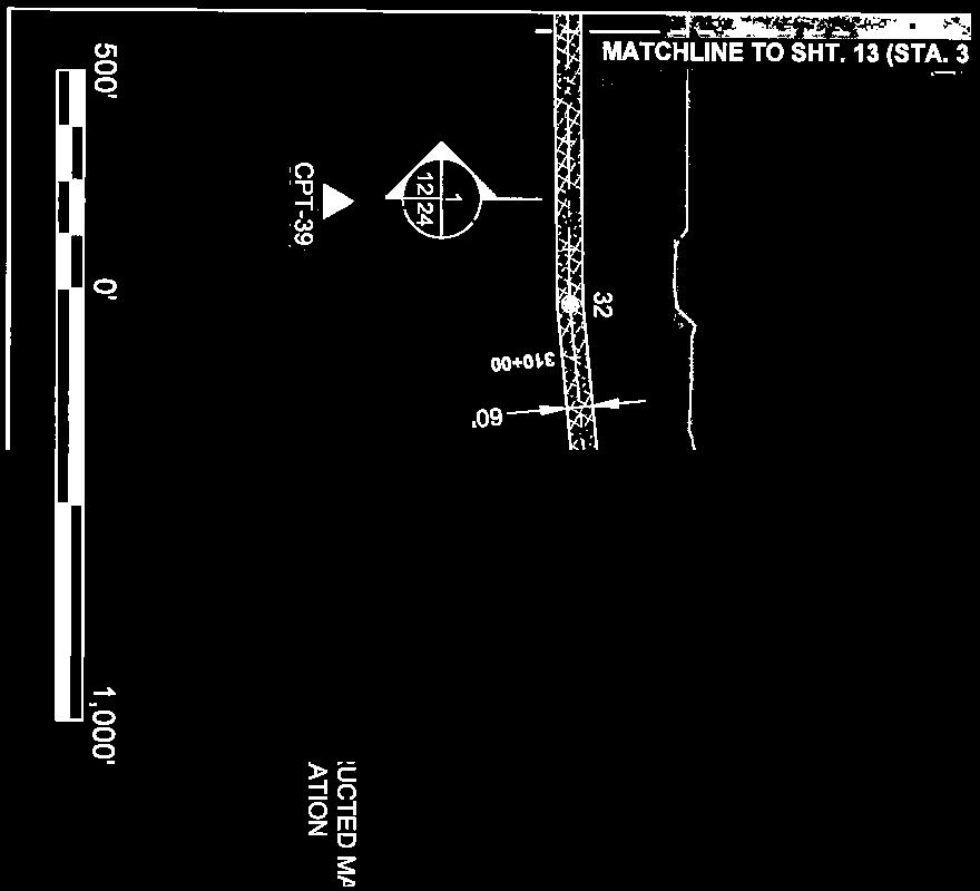
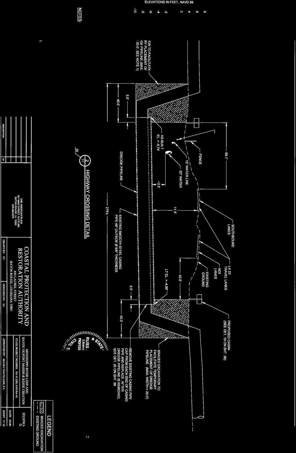
10 to BA-43WB. The below paragraphs provide a detailed summary of some of the types of crossing that maybe required for BA-43WB. Permanent and Temporary Canal Crossings The final bid plans for BA-43EB and BA-48 denoted two types of canal crossings, permanent and temporary. The criteria for determining the location of permanent or temporary canal crossings was not clearly defined in the provided design reports and plans. Both types of canal crossing required the placement of culverts in the direction of water flow and backfilling over the culverts in the canal. The design of both canal crossings called for three 30 culverts to be placed in the canal. Furthermore, the design of both canal crossings called for backfill materials to be sloped with 20(H):1(V) slopes in the direction of the access corridor, and sides sloped with 2(H):1(V) slopes. The backfill material for permanent canal crossings will be compacted to 95%, and the side slopes will be armored with geotextile fabric and rip-rap to protect from erosion. Similar design approaches for BA-43WB may be required for the crossing of drainage canals, abandoned oil and gas canals, or areas where natural/historical hydrology must be maintained/restored. Bayou/Underwater Crossings For the crossing of Bayou DuPont in BA-43EB, the dredge pipe will be buried beneath the bayou bottom. An adjacent area to bayou crossing maybe excavated to allow sufficient depth for the placement and anchoring of a barge-mounted booster pump. Similar design approaches for BA- 43WB maybe used to cross small bayous and major navigable waterways, such as the Barataria Waterway and the Harvey Cutoff. However, the navigable channel must have sufficient depth to allow for the placement and burial of the pipeline because of the presumed size/diameter of the LDSP. Depending on the jurisdiction of the waterway being crossed, consulting with the U.S. Army Corp of Engineers (USACE) and U.S. Coast Guard (USCG) will be required prior to design and construction of an underwater crossing. Bridge Crossings According to the BA-43EB final design plans at approximately station (STA) , the dredge pipe crosses a canal via an existing timber construction bridge. The bridge will be reconstructed with a pre-cast concrete deck to allow for permanent access along the corridor. The approaches to the bridge will be backfilled, built-up, and armored with geotextiles, soil-anchors, and rip-rip. This design approach should be considered as an alternative to temporary and permanent canal closure for areas where key drainage features must stay open during construction and after completion of BA-43WB. Because of the remote nature of BA-43WB, this particular design approach may not be economical feasible. Further investigation and evaluation alignment and alternates will be needed to determine if any bridge crossings may be needed. 1.3 Pumps Booster Pumps for BA-43EB The sizing and placement of booster pumps will be determined by size of dredge used and will be left up to contractor for selection. According to the LDSP planning report, approximately four (4) booster pumps may be needed to convey the sediment slurry from the project origin in Plaquemines Parish to project termination in northern Lafourche Parish. Furthermore, the planning report states the first pump will most likely be land-based and supplemental booster pumps will be water-based. The final design report specifies booster pumps should only be 10
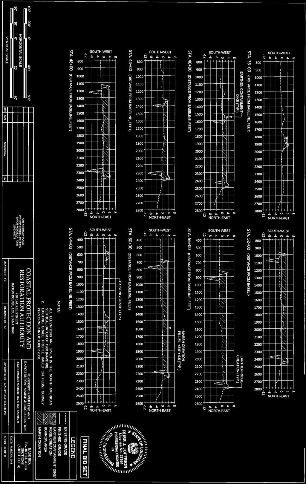
11 operated in positive suction, meaning that the booster pumps must have enough power to maintain positive pressure in the line between pumps to avoid loss of efficiency and/or damage as a result of negative pressure. Per discussion with WMI, two 4,000 horsepower (HP) electric booster pumps will be used. The electric booster pumps will be land-based and will draw power from the available electrical grid. Where required, additional diesel powered booster pumps will be water-based and be floated in via barge using available waterways. According to LDSP planning report, booster pumps will not be permanently be placed due to a variety of factors, such as protection from storms, maintenance, and vandalism. Boosters Pumps for BA-43WB Due to the long distance conveyance of sediment from Mississippi River, booster pumps will need to be staged along the eastern and western portions of the alignment to convey the sediment slurry along BA-43WB. Because of the remote nature of the BA-43WB project site, the use of water-based, diesel booster pumps will be required. Existing canals can be widened and deepened to allow sufficient draft for the movement of water-based booster pumps and equipment barges. The sizing and placement of booster pumps can be designated; however, pump sizing and placement will be left up to the contractors means and methods. Like BA-43EB, it is easily foreseeable the booster pumps required for BA-43WB will not be placed permanently in the marsh because of protection from storms, maintenance, and vandalism. 1.4 Earthen Construction Containment Dikes According to final design plans for BA-43EB and BA-48, earthen containment dikes will be required in certain areas for the construction of ridges and marsh. Earthen containment dikes will be constructed using in-situ soils; dikes will be shaped with 4(H):1(V) slopes and approximately six-foot wide crown. The containment dikes will be constructed to an elevation of +4.0 NAVD88 to allow for approximately 1.0 of freeboard. Based on review of the available reports, borrow areas for containment dike material should be located within the marsh creation or ridge creation area. Borrow areas should be located at a minimum of approximately 25 feet from the toe of the dike and be sloped with 3(H):1(V) sloped to maximum depth of NAVD88. Ridge Restoration As part of the marsh creation efforts for BA-43EB, ridges will simultaneously be constructed adjacent to marsh creation areas. These ridges will be constructed along the banks of Bayou DuPont beginning at approximately STA The Bayou DuPont ridges are a separate project to restore marsh and historical ridges along this bayou; however, the Bayou DuPont marsh and ridge creation efforts will be integrated into a larger Barataria Basin land-bridge project. The ridges at Bayou DuPont will intersect and be incorporated into the land-bridge project. The ridges will primarily be constructed using in-situ soils and use a containment dike for the base of the ridge. On the marsh side of the ridge, hydraulic fill will be placed against the containment dike. Additional in-situ soils will be added to provide final ridge geometry. Final ridge geometry will be as follows: elevation +4.5 NAVD88, 4(H):1(V) front slope, 25-feet flat cap, 5(H):1(V) back slope. 11
12 Marsh Platform and Marsh Apron Creation Marsh creation will be performed by pumping hydraulically dredged sediment from the river into designated contained and uncontained areas. Low-ground pressure (LGP) dozers will be used to help place hydraulically dredged materials in the marsh creation areas. Marsh-fill elevation for the Bayou DuPont marsh creation project has been determined to be +3.0 NAVD88. At the chosen fill elevation, the project will settle and remain in the intertidal zone for its 20 year design life. As part of the marsh creation, a permanent sediment pipeline access corridor will be constructed. The sediment pipeline access corridor will typically measure 60 feet wide and be part of the marsh platform. The marsh platform will be an additional 130 feet to 310 feet of land depending on its location within the project; the marsh platform and land bridge will be constructed to an elevation of +3.0 ±0.5 NAVD88. The marsh platform will transition into a marsh apron. The marsh apron will be constructed to slope down to existing grade with 25(H):1(V) slopes which will measure approximately 45 feet to 160 feet wide. Anticipated Earthen Construction for BA-43WB Because of the similar nature of the projects and poor soil conditions generally seen throughout coastal Louisiana, BA-43WB will most likely be designed and constructed using similar methods. Certain areas along BA-43WB will have to be contained to prevent sediment from running-out into canals and waterways, but other areas will be uncontained. The sediment slurry will be pumped into the project area via hydraulic dredging. LGP dozers will likely be used to push and shape the marsh platform and marsh apron. However, geotechnical/subsurface conditions will dictate final fill elevations for BA-43WB. There are currently no ridge restoration projects proposed along BA-43WB. Should ridges be proposed and made part of BA-43WB, it is easily foreseeable the ridge will be constructed in a similar fashion. 1.5 Excavations and Dredging Dredging operations will occur in the Mississippi River near the Willis Point Anchorage or the Alliance Anchorage. All dredging operations in the Mississippi River are highly regulated by USACE and various other entities with shipping interest. USACE has strict guidelines and requirements of limits (i.e. borrow area geometry, excavation depth) of dredging in the river. According to the 95% design report for BA-43 EB, a 1.3 factor of safety for the slope stability of the river levee was maintained by using the Corps required 750 feet offset from the centerline of the levee. At the 750 feet offset, the maximum slope for dredging operations in the river was calculated to be approximately 5(H):1(V). Because the Mississippi River will most likely be the source for sediment for BA-43WB, similar engineering analysis will most likely be followed. Dredging operations will hydraulically dredge river sand for marsh and ridge creation. Per discussion with the dredging contractor, dredging for BA-43EB and BA-48 will use a 17,000 horsepower (HP) dredge with a 30 cutter-head. Land and water based booster pumps will be used to help convey sediment slurry to final placement areas. Because of similarities between BA-43EB and BA-43WB, a similarly sized dredge will mostly like be used. However, the size of the dredge and booster pumps will be dependent on what is available at the time of construction of BA-43WB. 12
13 For BA-43EB and BA-48, excavation of materials for containment dikes will occur in marsh and ridge creation areas using marsh buggy excavators and/or small bucket dredges. In order to reduce additional dredging for equipment access, marsh buggy excavators have been recommended because these types of excavators can safely operate in two to four feet of water. Limits of excavation are dictated by the location of pipelines and other oil-and-gas infrastructure, as well as geotechnical analysis and recommendations. Magnetometer, bathymetric, physical land surveys and geotechnical investigation will be required to locate and define existing utilities, water bottoms, physical conditions (topography), and subsurface soil conditions. Similar to BA-43EB and BA-48, BA-43WB will likely require the excavation of in-situ materials to construct containment dikes. Depending on the water depth and soil conditions, marsh buggy excavators, small bucket dredges, or a combination of both maybe used to construct earthen containment dikes. Excavation limits will need to be determined based on the findings of magnetometer surveys, bathymetric surveys, physical land/topographic surveys, and geotechnical investigation. 2 Future Design and Engineering Considerations The following discussion has attempted to highlight some of key design and engineering considerations that must be taken into account during the early design phases of BA-43WB. Navigational Crossings and Agency Coordination The most prominent concern will be the crossing of major navigable waterways, such as the Barataria Waterway, the Harvey Cutoff, and channel between Bayou Perot and Little Lake near the Jefferson and Lafourche Parish line. The design of these crossings will require agency input, guidance, and review; and thus will require close coordination amongst the design team, USACE, and USCG. Rubric Development A rubric or matrix will need to be developed to evaluate the preliminary alignments for BA-43WB and determine which alignment will be the most feasible. According to conceptual design report for the LDSP, the consulting team used a matrix consisting of three categories to evaluate and rank the access corridor alignments. These categories included constructability, environmental impacts, and legal. The categories were further divided into fourteen sub-categories for evaluation; some of the sub-categories included density of oil and gas wells and pipelines, impacts to cultural resources, property ownership, and state water bottoms. In addition to evaluating and ranking access corridor alignments, the final planning report discussed evaluating several options and cost alternatives for marsh creation, construction methods, and whether to leave or remove the sediment pipeline after construction. A matrix with similar categories and sub-categories may be needed to help evaluate the feasibility and constructability of each access corridor alignment, associated marsh creation, and establishing pipeline infrastructure. Data Acquisition Data acquisition and a plan for data acquisition must be developed. The plan must outline what to, how to, when to, where to conduct the survey(s) and investigation(s). Topographic surveys, archeological surveys, bathymetric surveys, magnetometer surveys, and geotechnical investigations must then be performed in order to obtain the physical data needed to design and engineer the project. Furthermore, archeological surveys will require coordination with the State Historic Preservation Office (SHPO) to 13
14 determine where cultural resources may exist and possibly be impacted. Findings from the archeological survey can possibly change the design (i.e. no work zones, shifting alignment) of the BA-43WB. All of the data will have to be carefully evaluated, interpreted, and processed to gain a full understand of the BA- 43WB project site. 3 Data Gaps and Design Criteria to be Determined After review of the provided documents, the following data gaps were determined to exist. Little or no information could be found on the following topics. Basis/criteria for permanent and temporary canal crossings Criteria for identifying possible cultural and historical resources Basis/criteria for selecting contained and uncontained areas for marsh creation Future projects that may be dependent on the Long Distance Sediment Pipeline/Land Bridge Criteria for and design information for crossing high-traffic, navigable waterways (i.e. Barataria Waterway) Location of pipeline on the Land Bridge In addition to the above discussed data gaps, the following design criteria/concerns will be need to be developed through further research. These items may also be dependent on the availability and development of information associated with the data gaps. Time frame for removal of temporary canal crossings Identification and determination of cultural or historical resources Selecting and locating contained/uncontained marsh creation areas 4 Sources/Reviewed Documents Bayou DuPont Marsh and Ridge Creation (BA-48): Draft 95% Design Report, Louisiana Office of Coastal Protection and Restoration: Restoration Division, October 2010 Mississippi River Long Distance Sediment Pipeline: Overall Planning and Conceptual Development, Moffatt & Nichol/CH2M Hill, January 14, 2011 Mississippi River Long Distance Sediment Pipeline: 30% Design Report, Moffatt & Nichol, January 16, 2012 Mississippi River Long Distance Sediment Pipeline BA-43EB / Bayou DuPont Marsh and Ridge Creation BA-48 (Final Bid Plans), Moffatt & Nichol/Coastal Protection and Restoration Authority, March

15 Zenith Street Metairie, LA Ph Fax OVERALL PLAN MARSH CREATION PROJECTS 15


16 Zenith Street Metairie, LA Ph Fax OVERALL PLAN - SHORELINE PROTECTION PROJECTS 16


17 Zenith Street Metairie, LA Ph Fax OVERALL PLAN - PROPERTY OWNERS 17
18 Mississippi River Delta 19 Priority Projects Briefing June 30, 2015 The Louisiana Room Louisiana Department of Wildlife and Fisheries 2000 Quail Drive Baton Rouge, LA 9:00am-5:00pm Agenda Welcome Cynthia Duet 9:00 Mississippi River Delta Coalition Project Priorities Document David Muth 9:05 Overview of CPRA Program Kyle Graham 9:15 Project Status Reports, by Basin: Pontchartrain-Maurepas Basin Projects: 9:40 West Maurepas Freshwater Diversion Carol Parsons Richards; Renee Bennett Central Wetlands Diversion Renee Bennett Golden Triangle Marsh Creation Vida Carver New Orleans East Land-Bridge Restoration Andrew Beall Short Break 11:00 Breton-Chandeleur Basin Projects: 11:15 Mid-Breton Sediment Diversion Kent Bollfrass Lower Breton Sediment Diversion Kent Bollfrass Bayou la Loutre Ridge Restoration Bren Haase Biloxi Marsh Oyster Reef Restoration Micaela Coner Lunch and Speaker, Chris Barnes : RESTORE Pot 3 12:30 Barataria Basin Projects: 1:30 Mid-Barataria Diversion - Micaela Coner Lower Barataria Diversion Kent Bollfrass Barataria Marsh Restoration via Sediment Conveyance Pipeline West Chris Allen; Devyani Kar 18
19 Barataria Pass to Sandy Point Barrier Island Restoration - Chris Allen Belle Pass to Caminada Pass Barrier Island Restoration Chris Allen; Renee Bennett Short Break 3:00 Terrebonne-Atchafalaya Basin Projects 3:15 Convey Atchafalaya River Water via the Gulf Intracoastal Waterway Austin Feldbaum Isles Dernieres Barrier Island Restoration Devyani Kar Timbalier Islands Barrier Island Restoration Bill Feazel Houma Navigation Canal Hydrologic Modification Ken Bahlinger Chenier Plain 4:30 Calcasieu Ship Channel Hydrological Modification Austin Feldbaum Freshwater Bayou to Southwest Pass Shoreline Protection Bren Haase Closing Remarks Cynthia Duet 5:00 19
20 U.S. Army Corps of Engineers Permit Application for the Mississippi River Long Distance Sediment Pipeline Prepared for Coastal Protection and Restoration Authority October
21 1.0 Purpose and Need for the Proposed Action 1.1 Introduction This Supplementary Environmental Document (SED) assesses the direct, indirect, and cumulative impacts associated with the construction of the Mississippi River Long Distance Sediment Pipeline (BA-43 EB) or LDSP project. The objective of the Proposed Action is to use Mississippi River sediments to restore and create marshes along a created access corridor within the Barataria landbridge region (located in central Barataria Basin), where delta wetlands are rapidly deteriorating. This SED has been prepared to support a decision to authorize two permits, one each under: Section 10 of the Rivers and Harbors Act of 1899 (33 USC 403) and Section 404 of the Clean Water Act (33 USC 1344). This SED provides documentation and analyses that comply with guidelines established by the Council on Environmental Quality (CEQ, 1997) for implementing the National Environmental Policy Act (NEPA) of This project has been developed as a coastal wetland restoration project that is consistent with mitigating the impact of Outer Continental Shelf activities that have affected the onshore environment, as specified under the Energy Policy Act of 2005, which created the Coastal Impact Assistance Program (U.S. Minerals Management Service [MMS], 2007). The Final Programmatic Environmental Assessment for Coastal Impact Assistance Program (CIAP) projects (MMS, 2007) provides guidance on the potential environmental benefits and impacts associated with restoration projects. Individual CIAP-funded projects are not subject to federal control and responsibility (40 Code of Federal Regulations [CFR] ) with regard to requiring NEPA documentation. MMS does not require completion of NEPA documents for individual CIAP projects based solely on the receipt of CIAP funds (MMS, 2007). Projects within the CIAP are funded for implementation by approval of CIAP grant requests from the Bureau of Ocean Energy Management, Regulation and Enforcement (BOEMRE). The project has a fixed budget of $66,192,104. CIAP would fund $33,692,104 and the State would fund $32,500,000 with Louisiana state surplus dollars. The initial engineering and design phase of this project is being funded with Louisiana surplus funds. The Coastal Protection and Restoration Authority (CPRA) is responsible for project oversight. It intends to proceed to the construction phase of this project and is acting under the authority as the state sponsor Project Location The proposed LDSP project is located in the eastern portion of lower Barataria Basin, defined as the region bordered by Bayou Lafourche on the west, and the Mississippi River on the east, and includes Plaquemines, Jefferson, and Lafourche Parishes moving from east to west from the Mississippi River (Figure 1-1). The eastern limit of the Proposed Action area extends along the Mississippi River between river miles (RM) 60 and RM 67 above the Head of Passes. The western limit is the Barataria Waterway. The northern boundary is WBG BTR
.")
22 SUPPLEMENTARY ENVIRONMENTAL DOCUMENT Chenier Traverse Bayou, and the southern limit is formed by an oil and gas canal (Figure 1-2). FIGURE 1-1 Vicinity Map 1-2 WBG BTR 22

23 1.0 PURPOSE AND NEED FOR THE PROPOSED ACTION FIGURE 1-2 Project Area of the Mississippi River Long Distance Sediment Pipeline WBG BTR
24 SUPPLEMENTARY ENVIRONMENTAL DOCUMENT The proposed sediment borrow areas are located at Alliance Anchorage South (RM 60), Alliance Anchorage (RM 64), and Wills Point (RM 67) in the Mississippi River (Figure 1-2). The proposed project area includes a total length of 13.3 miles, beginning in the Mississippi River channel and ending at the Barataria Waterway. Of the total length, 5.9 miles of the corridor would extend through sparsely populated agricultural areas. The remaining 7.4 miles would traverse intertidal wetland habitat. Outside of the river channel, the project area contains the following landscape features: river batture, river flood protection levee, hurricane protection levee, inactive river distributary wetlands, brackish marsh, shallow open water, and natural levee ridges. An extensive network of existing and abandoned oil and gas canals occupies a significant portion of the proposed wetland project area (Figure 1-2) Historical and Present Environmental Setting Barataria Basin and Wetland Loss The Barataria Basin comprises approximately 1.56 million acres, most of which is forested and emergent wetlands and tidal lakes. The apex of the estuary is formed by the connection of Bayou Lafourche (a historic distributary) with the Mississippi River. The wetlands of Barataria Basin were created by the shifting course of the Mississippi River over thousands of years. The upper portion of the Barataria Basin is mainly a freshwater-dominated system of natural levee ridges, swamps, and floating freshwater marshes (Sasser et al., 1986). The lower portion of the basin is a system of barrier islands, saline and brackish marshes, tidal channels, large bays, and lakes dominated by marine and tidal processes (Coastal Wetlands Planning, Protection and Restoration Act [CWPPRA], 2011). According to a recent U.S. Geological Survey (USGS) analysis of land area change in coastal Louisiana, the Barataria Basin has undergone a net loss in land area of about 456 square miles (mi 2 ) between the years 1932 and 2010, which is equivalent to one-third of the total land area in 1932 (Couvillion et al., 2011). From , Barataria Basin experienced the highest rate of wetland loss in the state, with > 50 square miles per year (mi 2 yr -1 ). Trend analyses from 1985 to 2010 showed an average wetland loss rate of 4.76 mi 2 yr -1, which is greater than any other basin in Louisiana s coastal zone (Couvillion et al., 2011). Wetland loss within the Barataria Basin has been attributed to sea level rise, shoreline erosion, accelerated subsidence along natural levees, hydrologic impacts caused by canal dredging and associated spoil material embankments that form impoundments, and saltwater intrusion (Sasser et al., 1986, Evers et al., 1992). Freshwater and sediment input was virtually eliminated with the construction of flood protection levees along the Mississippi River and the closure of Bayou Lafourche at Donaldsonville in the early 1900s. The long-term deprivation of sediments and freshwater has limited the capacity of these wetlands to withstand natural and anthropogenic stresses. There has been an effort to restore freshwater to the basin, with the siphons at Naomi and West Pointe a la Hache. Also, in 2002, the Davis Pond freshwater diversion from the Mississippi River, which has a 10,000-cubic-foot per-second (cfs) discharge capacity, was completed in the upper basin. Methods of restoring sediment transport to the basin are being investigated with controlled diversions (e.g., Myrtle Grove) and conveyance of sediments through river dredging. 1-4 WBG BTR 24
25 1.0 PURPOSE AND NEED FOR THE PROPOSED ACTION While marine transgression is the natural final sequence during delta evolution, in the Barataria Basin a number of anthropogenic disturbances have resulted in an accelerated decay of the delta wetlands: levee construction along the Mississippi River, extensive oil and gas exploration (canal construction), and navigation dredging from the gulf to the inland (Barataria Waterway). The upper, freshwater reach of Barataria Basin is separated from the gulf by a landbridge. The core of the landbridge has retained the skeletal delta framework capable of supporting restoration it is the last geomorphic feature protecting upper basin marshes, swamp forests, and coastal communities from marine influences. In the absence of a large-scale river diversion or an artificial sediment distributary such as the LDSP, the project area and upper basin marshes would likely experience accelerated loss. Restoring the Barataria landbridge is designed to provide storm surge reduction to low-lying communities, decrease the reach of tidal energy, and restore critical estuarine habitat. Summary of Barataria Basin Restoration Projects The LDSP is part of a comprehensive effort to restore the Barataria Basin. Coastal restoration efforts have been ongoing in the Barataria Basin since the early 1990s. Much of the funding for these projects has come through the CWPPRA and the Coastal Impact Assistance Program (CIAP) as well as other state and federal sources. Project types include hydrologic restoration, freshwater diversion, outfall management, barrier shoreline restoration, marsh creation, vegetative plantings, shoreline protection, and herbivory control. Table 1-1 lists the restoration projects in the Barataria Basin and their status. There would be a synergistic benefit among this suite of restoration projects in the basin, and implementation of the LDSP would make future marsh creation projects more cost-effective to construct by providing a pre-permitted, established corridor from which to mobilize dredge pipe and equipment. Hydrologic restoration projects such as the Gulf Intracoastal Waterway (GIWW) to Clovelly (BA-02) Hydrologic Restoration project seek to restore natural and historic water flow patterns and connections through the use of weirs, flap-gate structures, canal plugs, and spoil bank management. Freshwater diversion and outfall management projects such as the Davis Pond (BA-01) and Naomi Siphon and Outfall Management (BA-03) are designed to introduce freshwater and nutrients from the Mississippi River into the Barataria Basin in an effort to manage salinities and sustain marshes in the basin. Table 1-2 lists the marsh creation projects in the immediate vicinity of the Barataria landbridge. Barrier shoreline projects help to stabilize the coast and sustain barrier shoreline processes by restoring the geomorphic form and ecological function of barrier islands and barrier headlands by beach construction and nourishment. Examples of barrier shoreline restoration projects include the Pass Chaland to Grand Bayou Pass Barrier Shoreline Restoration (BA-35) project completed in 2009, as well as the Riverine Sand Mining/Scofield Island Restoration project. The latter project will utilize sediment dredged from the Mississippi River and transported via pipeline to restore a barrier island in lower Plaquemines Parish. Marsh creation projects such as the Mississippi River Sediment Delivery System Bayou Dupont (BA-39) as well as LDSP project utilize dredged sediment from the Mississippi River or other waterbottoms to construct and restore lost or degraded marshes. Vegetative plantings, shoreline protection, and herbivory control are strategies that are often implemented in conjunction with the previously mentioned projects to facilitate the growth of native vegetation as well as to protect and maintain project features. WBG BTR
26 SUPPLEMENTARY ENVIRONMENTAL DOCUMENT TABLE 1-1 Restoration Efforts within Barataria Basin. Project Number Project Name Status BA-01 Davis Pond Freshwater Diversion Completed in 2002 BA-02 GIWW to Clovelly Hydrologic Restoration Completed in 2000 BA-03 Naomi Siphon Diversion Completed in 1992 BA-03c Naomi Outfall Management Completed in 2002 BA-04 West Pointe a la Hache Siphon Diversion Completed in 1992 BA05 Queen Bess Completed in 1993 BA-05c Baie de Chactas Completed in 1990 BA-15 Lake Salvador Shore Protection Demonstration Completed in 1998 BA-15 15x1 Lake Salvador Shoreline Protection Extension Completed in 2005 BA-15x2 Lake Salvador Shoreline Protection Phase III Completed in 2009 BA-16 Bayou Segnette Completed in 1994/1998 BA-19 Barataria Bay Waterway Wetland Restoration Completed in 1996 BA-20 Jonathan Davis Wetland Protection Completed in 2003 BA-23 Barataria Bay Waterway West Side Shoreline Protection Completed in 2000 BA-26 Barataria Bay Waterway East Side Shoreline Protection Completed in 2001 BA-27 Barataria Basin Landbridge Shoreline Protection, Phases 1 and 2 Completed in 2002/2008 BA-27c Barataria Basin Landbridge Shoreline Protection, Phase 3 Completed in 2009 BA-27d Barataria Basin Landbridge Shoreline Protection, Phase 4 Completed in 2006 BA-30 EB East Grand Terre Scheduled for construction in 2011 BA-28 Vegetative Plantings of a Dredged Material Disposal Site on Grand Terre Island Completed in 2001 BA-35 Pass Chaland to Grand Bayou Pass Barrier Shoreline Restoration Completed in 2009 BA-36 Dedicated Dredging on the Barataria Basin Landbridge Completed in 2010 BA-37 Little Lake Shoreline Protection/Dedicated Dredging Near Round Lake Completed in 2007 BA-38 Barataria Barrier Island Complex Project: Pelican Island and Pass La Mer to Chaland Pass Pass La Mer to Chaland Pass Completed in 2007 Pelican Island Construction scheduled BA-39 Mississippi River Sediment Delivery System - Bayou Dupont Completed in 2010 BA-41 South Shore of The Pen Shoreline Protection and Marsh Creation Construction scheduled BA-42 Lake Hermitage Marsh Creation Construction scheduled BA-48 Bayou Dupont Ridge Creation and Marsh Restoration Construction scheduled 1-6 WBG BTR 26
27 1.0 PURPOSE AND NEED FOR THE PROPOSED ACTION TABLE 1-1 Restoration Efforts within Barataria Basin. Project Number Project Name Status Nutria Harvest and Control multiple projects Several additional projects are under development or have been considered as restoration projects, but have not been completely designed or scheduled for implementation. They include: Project Number Project Name Status BA-04c West Pointe a la Hache Outfall Management Pending BA-25b Mississippi River Reintroduction into Bayou Lafourche Pending BA-34 Mississippi River Reintroduction into Northwestern Barataria Basin Pending BA-40 Riverine Sand Mining/Scofield Island Restoration Pending BA-45 (E-B) BA-47 Caminada Headlands West Pointe a la Hache Marsh Creation Pending In design phase BA-68 BA-76 Grand Liard Marsh and Ridge Restoration Chenier Ronquille Barrier Island Restoration Pending Medium Diversion with Dedicated Dredging at Myrtle Grove Barataria Basin Shoreline Restoration (LCA) Modification of the Davis Pond Diversion (LCA) Pending Pending Pending Source: Louisiana Coastal Wetlands Conservation and Restoration Task Force, 2011 A series of marsh creation projects in the landbridge area are pending or have been implemented to address the lack of natural sediment input (Figure 1-3). Two marsh creation projects within the landbridge have been constructed with dredged sediments from the Mississippi River or within-basin sediments; two similar projects are pending. All four projects are summarized below and in Table 1-2. Completed Projects Dedicated Dredging on the Barataria Basin Landbridge (BA-36) The project was implemented to create 1,254 acres of marsh in the Barataria landbridge in the southern portion of Bayou Rigolettes and Bayou Perot using within-basin sediments. The project area had been experiencing annual rates of landloss of approximately 2.5% (of the land area), mostly due to interior marsh deterioration and wind- and wave-induced erosion. This project was completed in WBG BTR
28 SUPPLEMENTARY ENVIRONMENTAL DOCUMENT Mississippi River Sediment Delivery System (BA-39) This project was implemented to create 493 acres of marsh via hydraulic dredging of the Mississippi River and placement via a pipeline sediment delivery system. The project was performed in a rapidly deteriorating section of the landbridge adjacent to Bayou Dupont and southeast of Chenier Traverse Bayou. Marshes in the project area have degraded to open water with only scattered clumps of low-lying vegetation remaining. Marsh degradation has resulted from a combination of three factors: lack of natural freshwater and sediment input, subsidence, and the dredging of oil and gas canals. This project was completed in Pending Projects South Shore of the Pen Shoreline Protection and Marsh Creation (BA-41) This project site is located in the vicinity of Bayou Dupont and the Barataria Waterway in an area that has been eroding at a rate ranging from 5 to 30 feet per year and has also suffered significant interior wetland loss (Louisiana Coastal Wetlands Conservation and Restoration Task Force, 2010). The goals of this project are to stop shoreline erosion and to create and nourish marsh areas between The Pen and the Barataria Waterway. Approximately 11,750 feet of foreshore rock dike would be constructed along the south shore of The Pen and Bayou Dupont. Dredged material would be placed to create approximately 175 acres of marsh, and to nourish an additional 132 acres of existing marsh. The project is currently under construction and is anticipated to create 211 net acres. Bayou Dupont Ridge Creation and Marsh Restoration (BA-48) The goals of this project are (1) to create and nourish approximately 317 acres of marsh along Bayou Dupont southeast of the enclosure known as The Pen through pipeline sediment delivery from the Mississippi River and (2) to create approximately 15 acres of ridge habitat on a portion of the southwestern shoreline of Bayou Dupont. Landloss has caused the bayou to coalesce with adjacent water bodies and the ridge would help redefine the limits of the bayou to re-establish its natural bank that once protected adjacent marshes. According to the USGS, landloss due to subsidence, wind erosion, storms, and altered hydrology is occurring at a rate of 1.7% per year (of the land area). Engineering and design have been completed for BA-48 and a Joint Permit Application was submitted to the Louisiana Department of Natural Resource/Office of Coastal Management (LDNR/OCM) in July 2011 and construction is pending. 1.2 Purpose and Need Purpose The purpose of the Proposed Action is to: (1) obtain sediment from sustainable and renewable sources in the Mississippi River, (2) provide an adequate access corridor that supports equipment mobilization for long distance sediment conveyance, and (3) restore tidal wetlands along the Barataria landbridge. The project would be accomplished with CIAP funding from Lafourche, Jefferson, and Plaquemines Parishes in partnership with CPRA as well as state surplus funds. A net total of 371 acres of emergent marsh and 5.9 miles of access corridor would be constructed with 2.2 million cubic yards (Mcy) of dredged material from the Mississippi River. The constructed marsh would be planted with native vegetation following construction to accelerate the colonization and stabilization of substrate. 1-8 WBG BTR 28

29 1.0 PURPOSE AND NEED FOR THE PROPOSED ACTION FIGURE 1-3 Existing and Proposed Wetland Restoration Projects along the Barataria Landbridge WBG BTR
30 SUPPLEMENTARY ENVIRONMENTAL DOCUMENT TABLE 1-2 Coastal Restoration Projects within Barataria Landbridge Project Status Prior Wetland Loss Rate (% per year) Existing a Marsh Elevation (ft) Mean a Water Level (ft) Target Elevation (ft) Initial Fill a Elevation (ft) Area Created or Nourished (ac) BA-36: Dedicated Dredging on the Barataria Basin Landbridge Complete ,245 BA-39: Mississippi River Sediment Delivery System--Bayou Dupont Complete 2010 Converted to open water BA-48: Bayou Dupont Ridge Creation and Marsh Restoration Pending a = +/- ft NAVD88 Source: WBG BTR 30
31 1.0 PURPOSE AND NEED FOR THE PROPOSED ACTION There are multiple outcomes specific to this project that would provide immediate and longterm ecosystem benefits with regard to wetland restoration of the Barataria landbridge: Restore a contiguous reach of emergent wetlands along a delta landform. Re-establish the transport of available sediments to wetlands that were artificially isolated from natural river overflow. Provide an access corridor that can support the transport of large volumes of sediment for future projects that otherwise could not be reached cost effectively without this approach. Provide an access corridor that minimizes the incremental and cumulative future environmental impacts associated with individual projects that dredge water bodies for floatation access and pipeline conveyance Need While wetlands have provided coastal communities with flood protection and economic value, the anthropogenic isolation of the Mississippi River Delta from its floodplain has compromised the health and benefits of the coastal wetlands. The project area has experienced rapid loss of wetlands, partially due to sediment starvation and land subsidence. In the absence of the sediment subsidy, the emergent marshes in the project area would continue to deteriorate, exposing upper Barataria Basin swamps, freshwater marshes, and nearby communities to increased storm and tidal energy. Restoring wetlands in the northern portion of the basin would reduce the tidal prism, which would in turn reduce tidally driven scouring along the lower reaches of the basin and along the barrier shorelines that form the first line of defense against tropical storms. There is a need to ensure a longterm sustainable sediment supply and a restoration access corridor for cost-effective wetland creation to meet the State s commitment to restoring wetlands at the landscape scale. One of the cornerstones of Louisiana s Comprehensive Master Plan for a Sustainable Coast (CPRA, 2007) is the re-plumbing of freshwater and sediment pathways from the Mississippi River to nearby coastal marshes. It is possible to recycle sediment sources within coastal basins to restore local wetlands, but the LDSP project seeks to restore wetlands through the introduction of new sediment from outside of the basin, which is a more sustainable, long-term solution to wetland loss, especially when obtained from renewable sources such as the Mississippi River. As a system capable of rapid land building, the LDSP project has the capacity to rebuild land on a more aggressive time scale than either natural deltaic processes or the surrogate pathways intended to mimic them, such as freshwater and sediment diversions, which typically operate on a decadal scale before substantial landbuilding benefits are realized. The LDSP establishes an initial foundation for the programmatic wetland restoration of a landform. It fulfills the need for immediate benefits and improves the probability of future wetland restoration success. 1.3 Scope and Content of the SED This SED was prepared in accordance with NEPA and implementing regulations specified in 40 CFR Part 1500 through Part 1508, and 32 CFR Part 651. The purpose of this SED is to describe current environmental resources on and adjacent to the location of the proposed dredging, sediment pipeline construction, and marsh restoration and to inform decision- WBG BTR
32 SUPPLEMENTARY ENVIRONMENTAL DOCUMENT makers and the public of the potential environmental consequences of the project while presenting the rationale used for identifying and evaluating impacts. Design measures are identified and described where warranted. This SED identifies, documents, and evaluates potential environmental and socioeconomic effects of the Proposed Action and seeks to ensure that appropriate consideration has been given to environmental resources. It includes an evaluation of direct, indirect, and cumulative impacts, both temporary and permanent, that could occur as a result of implementing either of two identified action alternatives. Reasonably foreseeable future actions are identified in Section 5. Any additional requirements stemming from other unrelated actions would undergo separate NEPA analysis and evaluation. This SED also considers the potential impacts of the No Action Alternative, as required by NEPA. The No Action Alternative provides a benchmark against which the potential impacts of the Proposed Action and the other action alternative can be compared. An interdisciplinary team of environmental scientists, biologists, planners, and engineers have analyzed the Proposed Action and alternatives in light of existing conditions and has identified relevant beneficial and adverse effects associated with the Proposed Action and alternatives. 1.4 Decisions to be Made The primary decision to be made for the LDSP project pertains to the selection of an alternative for restoration of marsh along the Barataria landbridge and the issuance of environmental permits for the selected alternative. Alternatives are described in Section 2. Upon selection of an alternative, the (LDNR/OCM) and the U.S. Army Corps of Engineers (USACE) must evaluate the Joint Permit Application and make a determination on whether or not to issue Coastal Use and Section 404/10 permits, respectively. Permits for levee, road, and railroad crossings may also be required from Plaquemines Parish, the local levee board, the Louisiana Department of Transportation and Development (LDOTD), and the New Orleans Lower Coast Railroad. 1.5 Stakeholder Participation Numerous project partner and stakeholder meetings were held during the plan formulation phase of this project. Attendees at these meetings included state and federal resource agency representatives as well as representatives from Plaquemines, Jefferson, and Lafourche Parishes. The state and federal agencies included: USACE, U.S. Environmental Protection Agency (USEPA), National Oceanic and Atmospheric Administration (NOAA) National Marine Fisheries Service (NMFS), U.S. Fish and Wildlife Service (USFWS), Louisiana Department of Environmental Quality (LDEQ), and the Louisiana Department of Wildlife and Fisheries (LDWF), and the LDNR/OCM). The following meetings were held during plan formulation: Initial Stakeholder Meeting (March 2009) Project Partner Meeting (June, August, September, December 2009, February & September 2010, July 2011) 1-12 WBG BTR 32
33 1.0 PURPOSE AND NEED FOR THE PROPOSED ACTION Stakeholder Meeting (September 2009) Mississippi River Dredging Forum (April 2010) Input provided at these meetings was incorporated into the alignment and design of the project alternatives to reduce potential environmental impacts and to optimize the ecological benefits yielded by the project alternatives. WBG BTR
34 S upplementary Environmental Document Mississippi River Long Distance Sediment Pipeline Prepared for Moffatt and Nichol and the Louisiana Coastal Protection and Restoration Authority October
35 35
36 Executive Summary Purpose of the Supplementary Environmental Document This document, with its appendices, constitutes a Supplementary Environmental Document (SED) for the Mississippi River Long Distance Sediment Pipeline (LDSP) Project (BA-43-EB) prepared pursuant to the National Environmental Policy Act (NEPA) of 1969, (Public Law , 42 United States Code [USC] , as amended) and its implementing regulations, found at 40 Code of Federal Regulations (CFR) Part 61, App. A. The purpose of a SED is to present an assessment of the potential environmental impacts of a Proposed Action, a No Action or no project alternative, and other reasonable alternatives. The SED, the assessment it presents, and the procedures by which the environmental investigations are conducted and incorporated into the decision-making process, were established by NEPA to make sure that the environmental consequences of federal actions (e.g., decisions or projects) are taken into account. The process is designed to make sure that public officials make decisions based on a full understanding of the environmental impacts of Proposed Actions and take all appropriate steps to protect, restore and enhance the environment (40 CFR ). This SED has been prepared to support a decision to authorize two permits, one each under: Section 10 of the Rivers and Harbors Act of 1899 (33 USC 403) and Section 404 of the Clean Water Act (33 USC 1344). Purpose and Need of the Proposed Action In accordance with Council on Environmental Quality (CEQ) regulations ( ), this section briefly specifies the underlying purpose and need to which the State of Louisiana, Office of Coastal Restoration and Restoration, is responding by assessing the alternatives and selecting a Proposed Action. Purpose of the Proposed Action The purpose of the Proposed Action is to: (1) obtain sustainable and renewable sediment sources, (2) provide an adequate access corridor that supports equipment mobilization for long distance sediment conveyance, and (3) restore intertidal wetlands along the Barataria landbridge (located in central Barataria Basin). The project would be accomplished with Coastal Impact Assistance Program (CIAP) funding from Lafourche, Jefferson, and Plaquemines Parishes in partnership with the Coastal Protection and Restoration Authority (CPRA) and the State of Louisiana. Approximately 371 acres of emergent marsh and 48 acres (5.9 miles) of access corridor would be constructed with 2.2 million cubic yards of dredged material from the Mississippi River (Moffatt and Nichol, 2011a). The constructed marsh would be planted with native vegetation after construction to accelerate the colonization and stabilization of substrate. There are multiple goals specific to this project that, if met, would provide immediate and long-term ecosystem benefits with regard to wetland restoration of the Barataria landbridge: Restore a contiguous reach of emergent wetlands along a delta landform. WBG BTR ES-1 36
37 SUPPLEMENTARY ENVIRONMENTAL DOCUMENT Re-establish the transport of available sediments to wetlands that were artificially isolated from natural river overflow. Provide an access corridor that can transport large volumes of sediment for future projects that otherwise could not be reached cost effectively without this approach. Provide an access corridor that minimizes the incremental and cumulative future environmental impacts associated with individual projects that dredge water bodies for floatation access and pipeline conveyance. Need for the Proposed Action While wetlands have provided coastal communities with flood protection and economic value, the anthropogenic isolation of the Mississippi River Delta from its floodplain has compromised the health and benefits of the wetlands. The proposed project area has experienced rapid loss of wetlands, landforms that require sediment for survival. In the absence of a sediment subsidy, the emergent marshes in the project area would continue to deteriorate, exposing upper Barataria Basin freshwater marshes to increased storm and tidal energy. There is a need to provide a sustainable long-term sediment supply and a restoration access corridor for cost-effective wetland creation to meet the State s commitment to restoring wetlands at the landscape scale by aligning projects. One of the cornerstones of Louisiana s Comprehensive Master Plan for a Sustainable Coast (CPRA, 2007) is the re-plumbing of freshwater and sediment pathways from the Mississippi River to nearby coastal marshes. It is possible to recycle sediment sources within coastal basins to restore local wetlands, but the LDSP project seeks to restore wetlands with renewable sediment source in the Mississippi River. As a system capable of rapid land building, the LDSP project has the capacity to rebuild land on a more aggressive time scale than either natural deltaic processes or the surrogate pathways intended to mimic them. The LDSP establishes an initial foundation for the programmatic wetland restoration of a landform. It fulfills the need for immediate benefits and improves the probability of future wetland restoration success. Project Location The Mississippi River LDSP project (BA-43-EB) is located in the eastern portion of lower Barataria Basin, defined as the region bordered by Bayou Lafourche on the west, and the Mississippi River on the east, and includes Plaquemines, Jefferson, and Lafourche Parishes moving from east to west from the Mississippi River. The sediment borrow areas in the Mississippi River are located at Alliance Anchorage South (River Mile [RM] 60), Alliance Anchorage (RM 64), and Wills Point (RM 67). The project area includes a total length of 13.3 miles, which would begin in the Mississippi River channel and end at the Barataria Waterway. Of the total length, 5.9 miles of the corridor would extend through residential/agricultural landscape, whereas the remaining 7.4 miles would traverse intertidal wetland habitat. Outside of the river channel, the project area contains the following landscape features: river batture, river flood protection levee, rural residential area, hurricane protection levee, inactive river distributary wetlands, brackish marsh, shallow open water, and natural levee ridges. An extensive network of active and abandoned oil and gas canals occupies a considerable portion of the wetland project area. ES-2 WBG BTR 37
38 EXECUTIVE SUMMARY The eastern limit of the project area is formed along the Mississippi River between RM 60 and 67 above the Head of Passes. The western limit is the Barataria Waterway. The northern boundary is Chenier Traverse Bayou, and the southern limit is formed by an oil and gas canal; known locally as the Gate Canal. Project Description The LDSP project would dredge sediment from the Mississippi River and pump it through a pipeline to create an access corridor through approximately 7.4 miles of wetlands and open water. Along the access corridor and at its terminus, a net total of 262 acres of intertidal marsh would be created and an additional 109 acres would be nourished along the Barataria landbridge. This corridor would facilitate the implementation of future restoration projects in the vicinity of the project area. Through the CIAP and State funding (Surplus), $66.2 million for the first increment of the project has been secured, extending to the Barataria Waterway. Additional funding for the project would allow for future extensions of this corridor farther into Barataria Basin and across all three parishes, greatly increasing regional benefits. No Action and Action Alternatives No Action Alternative The No Action Alternative refers to the continuation of baseline conditions in the absence of the Proposed Action, in which case CPRA would not build the LDSP. While marine transgression is the natural final sequence during delta evolution, in the Barataria Basin the rate has accelerated with early delta abandonment (levee construction along the Mississippi River), extensive oil and gas exploration (canal construction), and navigation dredging from the gulf to the inland (Barataria Waterway). From , the Barataria Basin experienced the highest rate of wetland loss in the state, with > 50 square miles per year (mi 2 yr -1 ) (Couvillion et al., 2011). Trend analyses from 1985 to 2010 showed an average wetland loss rate of 4.76 mi 2 yr -1, which is greater than any other basin in Louisiana s coastal zone (Couvillion et al., 2011). The upper and lower Barataria Basin is separated by the landbridge. The landbridge has retained the skeletal delta framework capable of supporting restoration it is the last geographic feature protecting upper basin marshes, swamp forests, and communities from merging with the Barataria Bay and ultimately the Gulf of Mexico. In the absence of a largescale river diversion or an artificial sediment distributary like the LDSP, the project area and upper basin marshes would likely experience an accelerated loss. Under the No Action Alternative, there would be continued loss of emergent marsh that provides valuable estuarine fish and wildlife habitat. Proposed Action The CPRA proposes to construct a marsh restoration project with an access corridor at marsh elevation with sediments dredged from the Mississippi River. The sediment would be transported by pipeline from the Mississippi River and create 48 acres of access corridor would extend through approximately 5.9 mi of wetlands and open water. Along the access corridor, 194 acres of marsh would be constructed as a marsh apron. At the terminus of the WBG BTR ES-3 38
39 SUPPLEMENTARY ENVIRONMENTAL DOCUMENT access corridor, an additional marsh creation project would create 169 additional acres of brackish marsh. A net total of 371 acres of intertidal brackish marsh would be restored and nourished along the Barataria landbridge. The initial elevation of the access corridor and marsh restoration areas would be constructed to +3.0 ft North American Vertical Datum of 1988 (NAVD88) to allow for compaction and dewatering with time. The proposed LDSP project is part of the CIAP, which was developed to mitigate the impact of Outer Continental Shelf activities that have affected the onshore environment, as specified under the Energy Policy Act of This project would be consistent with recent State-Federal wetland restoration projects in the vicinity, which have used similar marsh restoration approaches to limit the reach of tidal energy into the upper Barataria Basin and provide estuarine fish and wildlife habitat. Affected Environment and Environmental Impacts The Affected Environment and Environmental Impacts portions of this SED describe the resources that would potentially be subject to impacts if the No Action Alternative, the Proposed Action, or the other evaluated alternatives were implemented. These resources include: climate, geologic conditions and soils, land use and land cover resources, transportation, hydrology, water resources and water quality, floodplains, socioeconomic resource, biological resources, cultural and archeological resources, visual and aesthetic resources, hazardous materials, utilities, air quality, noise, and health and safety. Table ES-1 summarizes the environmental impacts of the No Action Alternative, the Proposed Action, and the other action alternative that was carried forward for detailed analysis. ES-4 WBG BTR 39
40 EXECUTIVE SUMMARY TABLE ES-1 Comparison of Impacts of Considered Alternatives Resource Area Chenier Traverse South Alternative Oil and Gas Canal Alternative No Action Alternative Climate No impacts No impacts No impacts Geology and Soils Minor temporary impacts to sediments would occur at three borrow areas in the Mississippi River from sediment removal/mining. Minor long-term impacts from disturbance of soils on 48 acres (ac) of wetlands and waterbottom soils along the permanent pipeline corridor would occur. Earthwork would be required for site preparation, and there would be a minor increased potential for erosion during construction and demolition activities. Best Management Practices (BMPs) would minimize erosion potential. Beneficial impacts would result from restoration of lost soils in 371 ac of wetlands. Minor temporary impacts to sediments would occur at three borrow areas in the Mississippi River from sediment removal/mining. Minor long-term impacts from disturbance of soils on 62 ac of wetlands and waterbottom soils along the permanent pipeline corridor. Earthwork would be required for site preparation, and there would be a minor increased potential for erosion during construction and demolition activities. BMPs would minimize erosion potential. Beneficial impacts would result from restoration of lost soils in 316 ac of wetlands. Continued adverse impact of wetland soil loss through unabated soil erosion Land Use/Land Cover Positive long-term impacts to land cover would occur with 312 ac of open water (excluding Mississippi River borrow areas), Approximately 141 ac of marsh and 4.4 ac of developed land and spoil banks would be used for construction of the pipeline corridor. Land cover would be restored following completion of the project. Minor long-term impacts to prime farmlands would occur for construction of the pipeline route within the area protected by levees. Land would be restored following completion of the project. Beneficial permanent conversion of 262 ac of open water to marsh in restoration areas would occur. Positive long-term impacts to land cover would occur with 293 ac of open water (excluding Mississippi River borrow areas), Approximately 111 ac of marsh and 10.9 ac of developed land and spoil banks would be used for construction of the pipeline corridor. Land cover would be restored following completion of the project. Minor long-term impacts to prime farmlands would occur for construction of the pipeline route within the area protected by levees. Land would be restored following completion of the project. Beneficial permanent conversion of 226 ac of open water to marsh in restoration areas would occur. Continued degradation of existing wetland areas at a rate of % yr-1. WBG BTR ES-5 40
41 41
42 42


43 43


44 44


45 45


46 46


47 47


48 48


49 49


50 50


51 51


52 52


53 53


54 54


55 55


56 56


57 57


58 58


59 59


60 60


61 61


62 62


63 63


64 64


65 65


66 66


67 67


68 68


69 69


70 70


71 71


72 72


73 73


74 74


75 75


76 76


77 77


78 78


79 79


80 80


81 81


82 82


83 83


84 84


85 85


86 86


87 87


88 88


89 89


90 90


91 91


92 92


93 93


94 94


95 95


96 96


97 97


98 98


99 99


100 100

101 101


102 102


103 103


104 104


105 105


106 106


107 107


108 108


109 109


110 110


111 111


112 112


113 113


114 114


115 115


116 116


117 117


118 118


119 119


120 120


121 121


122 122
123 123


124 Integrated Ecosystem Restoration & Hurricane Protection in Coastal Louisiana: Fiscal Year 2016 Annual Plan committed to our coast 124
125 With the passage of Act 8 of the First Extraordinary Session of 2005 (Act 8), the Louisiana Legislature mandated the integration of hurricane protection activities (e.g., levee construction) and coastal restoration activities (e.g., river diversions or marsh creation). Act 8 also created the Coastal Protection and Restoration Authority (CPRA) and tasked it with oversight of these activities. The Office of Coastal Protection and Restoration (OCPR) was designated as the implementation arm of the CPRA. To avoid confusion, the 2012 Louisiana Legislature changed the name of the state agency from OCPR to CPRA. The CPRA is required by Act 523 of the 2009 Regular Legislative Session, to produce an Annual Plan that inventories projects, presents implementation schedules for these projects, and identifies funding schedules and budgets. This Fiscal Year (FY) 2016 Annual Plan provides an update on the state s efforts to protect and restore its coast and describes the short-term and longterm results that citizens can expect to see as the state progresses toward a sustainable coast. 125
126 Fiscal Year 2016 Annual Plan: Integrated Ecosystem Restoration and Hurricane Protection in Coastal Louisiana Submitted to the Senate Natural Resources Committee House Natural Resources and Environment Committee Senate Transportation, Highways and Public Works Committee House Transportation, Highways and Public Works Committee by The Coastal Protection and Restoration Authority of Louisiana In accordance with R.S. 49: and R.S. 49:

127 Coastal Protection and Restoration Authority Board Members Chip Kline, Chair Governor's Executive Assistant for Coastal Activities Stephen Chustz Secretary, Louisiana Department of Natural Resources Keith Lovell, Designee Sheri Lebas Secretary, Louisiana Department of Transportation and Development Richard Savoie, Designee Robert Barham Secretary, Louisiana Department of Wildlife and Fisheries Randy Pausina, Designee Peggy Hatch Secretary, Louisiana Department of Environmental Quality Stephen Moret Secretary, Louisiana Department of Economic Development Mike Strain Commissioner, Louisiana Department of Agriculture and Forestry Brad Spicer, Designee Kristy Nichols Commissioner, Louisiana Division of Administration Craig Taffaro, Designee R. King Milling Chair, Governor's Advisory Commission on Coastal Protection, Restoration and Conservation Kevin Davis Director, Governor's Office of Homeland Security and Emergency Preparedness 127

128 Jim Donelon Commissioner, Louisiana Department of Insurance Warren Byrd, Designee Joe Hassinger Southeast Louisiana Flood Protection Authority-East Representative East of the Atchafalaya River John Young Jefferson Parish President Representative East of the Atchafalaya River Steve Wilson Pontchartrain Levee District Representative East of the Atchafalaya River Windell Curole South Lafourche Levee District Representative East of the Atchafalaya River Bill Hidalgo St. Mary Levee District Representative West of the Atchafalaya River Billy Nungesser Plaquemines Parish President Representative East of the Atchafalaya River Laurie Cormier Calcasieu Parish Representative West of the Atchafalaya River Senator Blade Morrish, Ex-officio Designee of Senate President John Alario Representative Gordon Dove, Ex-officio Designee of Speaker of the House Chuck Kleckley 128

129 This public document was published at a total cost of $7,020. Five hundred copies of this public document were published in the first printing at a cost of $7,020. The total cost of all printings of this document was $7,020. The document was published by the Coastal Protection and Restoration Authority of Louisiana. This material was printed in accordance with standards of printing for State agencies established in R.S. 43:31. Printing of this material was purchased in accordance with the provisions of Title 43 of the Louisiana Revised Statutes. This plan was created by an interdisciplinary team from the CPRA led by Kyle Graham, Robert Routon, Joe Wyble, Jenny Kurz, Chuck Perrodin, Andrea Galinski, Chris Boudreaux, and Rocky Wager (USGS). Coastal Protection and Restoration Authority, Fiscal Year 2016 Annual Plan: Integrated Ecosystem Restoration and Hurricane Protection in Coastal Louisiana. Coastal Protection and Restoration Authority of Louisiana. Baton Rouge, LA. 129
130 130
131 Purpose of the Annual Plan Origin of the Annual Plan This plan is the annual report card used to track the progress of projects outlined in Louisiana s Comprehensive Master Plan for a Sustainable Coast. Additional information and projections are included to foster a better understanding of what is being done and why and how it is being done. In 2007, in response to Act 8 s directive, the State released Integrated Ecosystem Restoration and Hurricane Protection: Louisiana s Comprehensive Master Plan for a Sustainable Coast (2007 Coastal Master Plan). The 2007 Coastal Master Plan established four planning objectives as benchmarks for implementing coastal protection and restoration projects and identified large-scale measures needed to achieve a sustainable coast. The 2007 Coastal Master Plan was passed unanimously in the Louisiana Legislature and its primacy was subsequently reaffirmed by Gov. Bobby Jindal in Executive Order BJ2008-7, which directed all state agencies to administer their activities, to the maximum extent possible, in accordance with the 2007 Coastal Master Plan s recommendations. To accommodate the dynamic nature of coastal processes, Act 8 specifies that the Coastal Master Plan is a living document that will be updated approximately every five years. These updates incorporate new data and planning tools as they become available. To comply with the mandate set forth in Act 8, the first update of the Coastal Master Plan was submitted to the Louisiana Legislature in March It was unanimously adopted. The next update will be due in Evolution of the Annual Plan Act 523 of the 2009 Regular Legislative Session directed the CPRA to produce an Annual Plan each year that inventories integrated coastal protection projects, presents implementation schedules for these projects, and identifies funding schedules and budgets.* Historically, the state s Annual Plans for coastal projects provided: 1) an inventory of projects for which the state planned to expend money and resources for a given fiscal year, and 2) recommendations for allocating Coastal Protection and Restoration Funds to those projects. The FY 2010 Annual Plan was the first plan to address the new integrated planning and prioritization directives specified in Act 8. The FY 2016 Annual Plan fulfills the legislative mandate of Act 8 by presenting the CPRA s three-year program for funding and implementing projects during FY 2016 FY Additionally, the FY 2016 Annual Plan builds on the process first begun in the FY 2010 plan and provides an expanded discussion of the CPRA s progress in protecting and restoring the coast. Section 2 provides a summary of some of the progress and accomplishments achieved through FY2015; Section 3 outlines an implementation plan for FY 2016; Section 4 gives fiscal projections for FY 2016 to 2018; and the Appendices provide detailed information on CPRA projects, programs and initiatives. *La R.S. 49:214.29(4) defines integrated coastal protection as plans, projects, policies, and programs intended to provide hurricane protection or coastal conservation or restoration, and shall include but not be limited to coastal restoration; coastal protection; infrastructure; storm damage reduction; flood control; water resources development; erosion control measures; marsh management; diversions; saltwater intrusion prevention; wetlands and central wetlands conservation, enhancement, and restoration; barrier island and shoreline stabilization and preservation; coastal passes stabilization and restoration; mitigation; storm surge reduction; or beneficial use projects. 131

132 Table of Contents Section 1 Executive Summary... 2 Section 2 Progress to Date: Results on All Fronts... 9 Section 3 FY 2016 Implementation Plan: More Projects, More Action, More Results...31 Section 4 Projections: FY Section 5 Appendices...69 A. Ongoing Protection and Restoration Project Summaries B. Three-Year Expenditure Projections C. Barrier Island Status Report D. Caernarvon & Davis Pond Operational Plans for 2015 E. Inventory of Non-State Projects A. Parish CIAP Projects B. Federal Protection Projects C. Projects and Project Concepts in Coastal Parish Master Plans D. Restoration Partnership Projects F. CPRA FY 2016 Capital Outlay Requests 132
133 List of Figures Section 1 Executive Summary Figure ES-1: Projected FY 2016 Expenditures by Project Phase...5 Section 2 Last Year: Refining Our Path Forward Map 2-1: Projects Scheduled to be in Construction in FY Map 2-2: Projects Scheduled for Completion in FY Section 3 FY 2016 Implementation Plan: More Projects, More Action, More Results Map 3-1: Active State Projects in FY 2016 Eastern Region Map 3-2: Active State Projects in FY 2016 Central Region Map 3-3: Active State Projects in FY 2016 Western Region Map 3-4: Projects Scheduled to be in Construction in FY Map 3-5: Projects with Operation, Maintenance and Monitoring Expenditures in FY Section 4 Projections: FY Figure 4-1: Projected FY 2016 Expenditures by Project Phase Figure 4-2: Projected FY 2017 Expenditures by Project Phase Figure 4-3: Projected FY 2018 Expenditures by Project Phase
134 List of Tables Section 1 Executive Summary Table ES-1: Projected Three-Year Revenues (FY FY 2018)...3 Table ES-2: Projected Three-Year Expenditures (FY FY 2018)...4 Section 2 Last Year: Refining Our Path Forward Table 2-1: Projects Scheduled to be in Construction in FY Table 2-2: Projects Scheduled to Complete Construction in FY Section 3 FY 2016 Implementation Plan: More Projects, More Action, More Results Table 3-1: Projects Scheduled to be in Construction in FY Table 3-2: Projected Three-Year Schedules for Active CWPPRA Projects (FY ) Table 3-3: Projected Three-Year Schedules for Active WRDA Projects (FY ) Table 3-4: Projected Three-Year Schedules for Active CIAP Projects (FY ) Table 3-5: Projected Three-Year Schedules for Active State-Only Projects (FY ) Table 3-6: Projected Three-Year Schedules for Active CDBG Projects (FY ) Table 3-7: Projected Three-Year Schedules for Active HSDRRS Projects (FY ) Table 3-8: Projected Three-Year Schedules for Active and Proposed Oil Spill Projects (FY ) Section 4 Projections: FY Table 4-1: Projected Three-Year Revenues (FY FY 2018) Table 4-2: Projected Three-Year Expenditures (FY FY 2018) Table 4-3: Programmatic Projected Three-Year Expenditures (FY FY 2018) Table 4-4: State Protection and Restoration Projected Three-Year Operating Expenditures (FY FY 2018)

135 Section 1 Executive Summary
 $1.")
 MILESTONES $29 Million (Other Restoration Projects) constructed (Other")
 headed to construction 2007 Louisiana s first comprehensive Coastal Master Plan approved to bid")


136 CPRA HIGHLIGHTS $18 Billion secured for protection and Investment in projects constructed since establishment of Coastal Master Plan $8.73 Billion $2.39 Billion $55 Million (Infrastructure Projects) $1.024 Billion $475 Million $362 Million $92 Million (Hydrologic Restoration) $40 Million (Diversions) $2 Million (Oyster Barrier Reefs) MILESTONES $29 Million (Other Restoration Projects) constructed (Other Protection Projects) under construction Protection Projects Restoration Projects (Marsh Creation) (Shoreline Protection) headed to construction 2007 Louisiana s first comprehensive Coastal Master Plan approved to bid in FY2015 (Hurricane and Storm Damage Risk Reduction System) (Barrier Island / Headland Restoration) restoration projects 95.4 Million cubic yards of fill placed 26,241 acres of land benefited 256 miles of levee improved 45 miles of barrier islands and berms constructed 20 number of parishes with constructed projects 9 active dredges in 2014 At Bayou Dupont, riverine sediment is used for marsh creation for the first time The Caminada Headlands project is the first to use an offshore shoal for headland restoration 2009 Coastal Master Plan updated 2013 The Water Campus is announced 2012 and unanimously approved The Water Institute of the Gulf is established BY THE NUMBERS 2012 The Scofield Island project is the first to use riverine sediment for barrier island restoration 2014 Largest construction contract in the program s 136history awarded for Caminada Headland
137 Section 1 Executive Summary Section 1 Executive Summary The FY 2016 Annual Plan contains budget projections (Tables ES-1 and ES-2) that show projected revenues and the amount of funds that would actually be needed to accomplish the proposed implementation plan over the next three fiscal years. Resources in FY 2016 will be focused on constructing coastal projects that have already been planned and/or designed (Figure ES-1). Funding projections include state budget surplus funds allocated for coastal projects. The implementation plan and funding projections presented in the FY 2016 Annual Plan represent a snapshot in time based on the available funding sources. The state is actively exploring new sources of funding to ensure that the coastal program maintains its current momentum, including Clean Water Act (CWA) penalties resulting from the Deepwater Horizon oil spill, future Gulf of Mexico Energy Security Act (GOMESA) funding, and credit initiatives that would generate revenue from the carbon sequestration and water quality benefits of constructed projects. The state is also exploring, as part of the Natural Resources Damage Assessment (NRDA) for the Deepwater Horizon oil spill, the implementation of coastal restoration projects to address injuries to natural resources caused by the spill. Stay Informed New project opportunities may arise if additional funds become available after the approval of the FY 2016 Annual Plan, and conditions may necessitate reprogramming of existing funds to address changes on the ground. If necessary, reprogramming of existing and new funds would occur, with approval from the CPRA, to ensure that limited coastal program funds are allocated to the areas of greatest need and in a manner that will provide the greatest overall benefit to the coast. Such flexibility allows the coastal program to respond effectively to unforeseen events that take place outside the legislatively mandated planning cycle. We encourage you to join us as we move forward in our efforts to protect and restore coastal Louisiana. The CPRA Board conducts monthly meetings to provide a forum for updates and public discussion of our current work. In addition, many new tools are being developed to allow greater visibility of our progress and to provide increased access to information. These resources and information about upcoming meetings can be found online at Integrated Ecosystem Restoration & Hurricane Protection in Louisiana: Fiscal Year 2016 Annual Plan 137
138 Section 1 Executive Summary Table ES-1: Projected Three-Year Revenues (FY FY 2018) Revenue Sources FY 2016 FY 2017 FY 2018 Program Total (FY FY 2018) CPR Trust Fund Annual Revenue 1,2 $27,600,000 $27,900,000 $28,400,000 $83,900,000 CPR Trust Fund Carried Forward $11,297,895 $0 $0 $11,297,895 GOMESA 1 $80,775 $80,775 $140,000,000 $140,161,550 DOTD Interagency Transfer 1 $4,000,000 $4,000,000 $4,000,000 $12,000,000 DOTD Interagency Transfer - Projects $277,633 $138,817 $0 $416,450 CWPPRA Federal Funds 3 $72,337,669 $75,214,854 $75,168,429 $222,720,952 CIAP $79,571,255 $17,997,486 $0 $97,568,741 Surplus '07, '08, '09 $218,204,372 $68,050,495 $27,581,400 $313,836,268 Community Development Block Grants $11,800,838 $4,940,749 $0 $16,741,587 Capital Outlay Funds $9,599,885 $0 $0 $9,599,885 Deepwater Horizon NRDA $151,229,000 $92,812,699 $9,981,161 $254,022,860 NFWF $153,163,709 $15,191,510 $9,275,194 $177,630,413 Proposed RESTORE Revenues $28,954,397 $24,483,191 $78,474,156 $131,911,744 LDNR Mitigation Funds 4 $800,000 $0 $0 $800,000 LDNR Beneficial Use Funds 4 $500,000 $0 $0 $500,000 Iberia Parish IGA 5 $380,000 $0 $0 $380,000 St. Mary Levee District Funds 6 $875,000 $0 $0 $875,000 MOEX Settlement 7 $3,226,712 $435,847 $1,409,400 $5,071,959 OCD-DRU Grant 8 $675,000 $0 $0 $675,000 Berm to Barrier 9 $99,544 $104,612 $99,687 $303,843 OM&M Federal Funds 10 $36,725,819 $29,835,671 $17,246,556 $83,808,046 FEMA Claims for OM&M 11,12 $1,510,886 $0 $0 $1,510,886 FEMA Claims for Isaac Beach and Dune Project Repair 13 $34,562,851 $34,562,851 $0 $69,125,702 Additional Funding for Isaac Beach and Dune Project Repair $11,390,037 $11,260,793 $0 $22,650,830 LOSCO Funding 14 $1,200,000 $0 $0 $1,200,000 RESTORE Adaptive Management $2,400,000 TBD TBD $2,400,000 Project Billing $21,000,000 $21,000,000 $21,000,000 $63,000,000 Capital Outlay Request Submitted for HSDRRS 30-Year Payback $0 $0 $0 $0 Total Projected Revenue $883,463,278 $428,010,350 $412,635,983 $1,724,109,611 Notes 1. Annually recurring revenue source to be spent in accordance with the Louisiana Constitution, specifically State Law Section (E) and the provisions within paragraph (3). 2. Revenue forecast tied to mineral revenue. 3. Represents anticipated Federal reimbursement for CWPPRA projects led by CPRA in which the State is initially incurring more than its 15% cost share during project implementation. 4. Supplemental funding to augment construction of eligible projects (specific projects to be determined at a later date). 5. Used to partially fund TV Used to partially fund TV Represents anticipated balance as of FY 2016 of an initial deposit of $6.75 million of funds from the MOEX settlement. 8. Used to fund Coastal Community Resiliency Program. 9. Used to fund monitoring of constructed Berm to Barrier projects. 10. Represents anticipated Federal reimbursement for CWPPRA and WRDA OM&M activities led by CPRA in which the State is initially incurring more than its cost share during project implementation. 11. Represents anticipated claims associated with recovery from past distasters which has been obligated by FEMA. 12. CPRA is pursuing FEMA recovery funding through the FEMA appeals process to restore the form and function of the Coastal Barrier Island Resource System (CBRS) units S01-S08 which were lost as a result of Hurricane Katrina. The cumulative cost of this restoration is estimated to be on the order of $500 million. 13. Represents anticipated claims from FEMA recovery funds through the FEMA appeals process to restore various beach and dune restoration projects damaged by Hurricane Isaac. 14. Represents reimbursement of expenditures for CPRA oil spill response activities. Integrated Ecosystem Restoration & Hurricane Protection in Louisiana: 138 Fiscal Year 2016 Annual Plan
139 Section 1 Executive Summary Table ES-2: Projected Three-Year Expenditures 1 (FY FY 2018) Program / Funding Source FY 2016 FY 2017 FY 2018 Program Total (FY FY 2018) CWPPRA State Expenditures (not including surplus expenditures) 2 $17,351,129 $14,785,146 $14,831,571 $46,967,846 CWPPRA Federal Expenditures 3 $72,337,669 $75,214,854 $75,168,429 $222,720,952 WRDA Project Expenditures (not including surplus or CIAP expenditures) $0 $0 $0 $0 CIAP Projects and Program Expenditures (not including surplus expenditures) $79,571,255 $17,997,486 $0 $97,568,741 Surplus Projects and Program Expenditures $218,204,372 $68,050,495 $27,581,400 $313,836,268 Community Development Block Grants $11,800,838 $4,940,749 $0 $16,741,587 HSDRRS 30-Year Payback 4 $0 $0 $0 $0 MOEX Project Expenditures $3,226,712 $435,847 $1,409,400 $5,071,959 DOTD Interagency Transfer - HNC Deepening Expenditures $277,633 $138,817 $0 $416,450 Capital Outlay Project Expenditures $9,599,885 $0 $0 $9,599,885 State-Only Project Expenditures (non-surplus) $2,166,000 $136,000 $136,000 $2,438,000 Deepwater Horizon NRDA Expenditures $151,229,000 $92,812,699 $9,981,161 $254,022,860 NFWF Expenditures (not including surplus expenditures) $153,163,709 $15,191,510 $9,275,194 $177,630,413 Proposed RESTORE Expenditures (not including surplus expenditures) $28,954,397 $24,483,191 $78,474,156 $131,911,744 LDNR Mitigation Expenditures 5 $800,000 $0 $0 $800,000 LDNR Beneficial Use Expenditures 5 $500,000 $0 $0 $500,000 Iberia Parish IGA Expenditures 6 $380,000 $0 $0 $380,000 St. Mary Levee District Expenditures 7 $875,000 $0 $0 $875,000 OM&M - State Expenditures (not including surplus or CIAP expenditures) $7,009,200 $8,280,149 $7,334,049 $22,623,398 OM&M - Federal Expenditures 8 $36,725,819 $29,835,671 $17,246,556 $83,808,046 OM&M - Marine Debris Removal (partially reimbursed by FEMA) 9 $1,640,130 $0 $0 $1,640,130 OM&M - Isaac Beach and Dune Recovery (partially reimbursed by FEMA) 10 $45,823,644 $45,823,644 $0 $91,647,288 Project Support $4,100,000 $4,000,000 $4,000,000 $12,100,000 Operating Costs (see Tables 4-3 and 4-4) $38,210,731 $46,936,966 $50,704,118 $135,851,815 Total Projected Expenditures $883,947,124 $449,063,224 $296,142,034 $1,629,152,382 Notes 1. Represents proposed expenditures provided that commensurate level of funding is received. 2. Because CWPPRA projects compete for funding annually, CWPPRA expenditures as presented in Appendix B (which include projected expenditures for approved projects only) do not adequately capture likely CWPPRA expenditures in outlying years. The State's estimated CWPPRA expenditures for FY FY 2018 are therefore based on prior years' expenditures. 3. Represents anticipated Federal reimbursement for CWPPRA projects led by CPRA in which the State is initially incurring more than its 15% cost share during project implementation. 4. Payback is based on current HSDRRS construction schedule; payback will not commence until completion of HSDRRS construction activities. According to current estimates, payback will commence in September 2019 with an estimated annual payment of $98.4 million. 5. Supplemental funding to augment construction of eligible projects (specific projects to be determined at a later date). 6. Used to partially fund TV Used to partially fund TV Represents anticipated Federal reimbursement for CWPPRA and WRDA OM&M activities led by CPRA in which the State is initially incurring more than its cost share during project implementation. 9. Represents anticipated reimbursement associated with recovery from past distasters which has been obligated by FEMA. 10. Represents anticipated reimbursement of FEMA recovery funds through the FEMA appeals process to restore various beach and dune restoration projects damaged by Hurricane Isaac. Integrated Ecosystem Restoration & Hurricane Protection in Louisiana: Fiscal Year 2016 Annual Plan 139
140 Section 1 Executive Summary Figure ES-1: Projected FY 2016 Expenditures by Project Phase 67% 9% 4% Construction ($588 million) Engineering and Design ($82 million) 4% 11% 5% Planning ($35.5 million) Operation, Maintenance and Monitoring ($101 million) Ongoing Programs and Initiatives ($40 million) Operating Costs ($38.2 million) Notes Construction includes Beneficial Use ($4 million) OM&M includes BIMP ($361,000). Repair/Rehabilitation of Projects ($1.1 million), Marine Debris Removal ($1.6 million), and Isaac Beach and Dune Recovery ($45.8 million). Ongoing Programs Includes Project Support ($4.1 million) TOTAL Expenditures $884 million Integrated Ecosystem Restoration & Hurricane Protection in Louisiana: 140 Fiscal Year 2016 Annual Plan

141 Section 1 Executive Summary Section 2 Progress to Date: Results on All Fronts Integrated Ecosystem Restoration & Hurricane Protection in Louisiana: 141 Fiscal Year 2016 Annual Plan 7

142 Section 2 Last Year: Refining Our Path Forward Larose to Golden Meadow Jean Lafitte The 48-mile ring levee system known as the Larose to Golden Meadow Flood Protection project allows approximately 27,000 people to continue their long cultural story in close-knit communities like Larose, Cut Off, Belle Amie, Galliano and Golden Meadow. A lock at the southern end of the system allows the free flow of navigation during normal times, but can be closed to serve as a safe harbor for marine vessels seeking refuge during storms, something of critical importance to the facilities at Port Fourchon, one of the nation s most vital ports for offshore and imported oil and gas. The CPRA has provided $27.8 million of State Surplus Funds to improve more than 23 miles of levees and floodwalls for the protection of these communities. Sitting at the apex of the Barataria Basin, the greater Jean Lafitte community is subject to all the ills wrought by coastal subsidence, saltwater intrusion, and ecological degradation. A long-desired ring levee system is under construction financed primarily through CPRA State Surplus funds. While no storm surge in the past 30 years has been higher than six feet, the new levee system will stand at 7.5 feet and have the foundational capacity to be heightened to 16 feet, the more desirable standard for 100-year storm protection. Photo by Susan Poag, NOLA.com The Times-Picayune archive The need for a ring levee is substantiated by the fact that the Jean Lafitte area has been damaged by six disasters since 2005, most recently by flooding from Hurricane Isaac in The community is just south of New Orleans on the West Bank. Integrated Ecosystem Restoration & Hurricane Protection in Louisiana: Fiscal Year 2016 Annual Plan 142
143 Section 2 Last Year: Refining Our Path Forward Project Engineering Advancements Lessons learned through years of project implementation and an increase in funds available for coastal restoration have enabled us to tackle larger and more complex projects. These factors have allowed us to tap sand sources outside of the active coastal system, infusing the sand-starved coastal system for long-term benefits and improving individual project sustainability. First Use of Riverine Sediment for Marsh Creation Never before had the Mississippi River been tapped by man for its sandy sediment to build marsh land, but that changed in 2009 when the Bayou Dupont Sediment Delivery System became the first project to use riverine sand for marsh creation. Its success has led to the building of thousands of acres via the same process, including the current expanded phase two of landbuilding along Bayou Dupont and the subsequent westward extension of land and marsh creation via the Long Distance Sediment Pipeline to follow. This pioneering project, less than 20 miles south of New Orleans, dredged approximately 2.6 million cubic yards of sandy material from the riverbed and delivered them five miles to the southeast via pipeline, creating more than 560 acres of intertidal marsh inside three areas defined by nearly 26,000 linear feet of earthen containment dikes. Another first for this project area is an agreement for a permanent right-of-way for a pipeline corridor to be used in newer phases of Bayou Dupont land creation and the Long Distance Sediment Pipeline project that will continue to build land and marsh westward into the Barataria Basin. This permitting arrangement and a unique partnership amongst CPRA, the landowner, and the governments of Plaquemines, Jefferson, and Lafourche Parishes will efficiently reduce red tape and save time and money as our projects progress now and into the future. First Use of Riverine Sediment for Barrier Island Restoration While Bayou Dupont was the first use of riverine material for large-scale marsh creation, Riverine Sand Mining/Scofield Island Restoration represents an even bigger engineering first: the use of Mississippi River sediment to restore a barrier island. It did what some said could not be done: dredging and then piping sediment a distance of 22 miles, the longest pipeline conveyance of its kind ever. This enabled the transport of 1.9 million cubic yards of river sand to create 150 acres of beach and dune on this once-withering barrier island. Another 1.5 million cubic yards of material created 360 acres of back marsh habitat. The method was subsequently used to rebuild another barrier island, nearby Shell Island. Riverine sand restored approximately 1.3 miles of shoreline and a combined 307 acres of beach and marsh. The next phase will add another 2.8 miles of gulf shoreline and 692 acres of beach and marsh. First Use of Offshore Shoal Sands for Barrier Headland Restoration Offshore sand from Ship Shoal in federal waters is being used in the CPRA s largest construction project to date: the Caminada Headland Beach and Dune Restoration projects located in Lafourche and Jefferson Parishes. This headland is important to the protection of the nation s vital energy hub at Port Fourchon and Integrated Ecosystem Restoration & Hurricane Protection in Louisiana: 143 Fiscal Year 2016 Annual Plan

144 Section 2 Last Year: Refining Our Path Forward serves as a central sand source to the down-drift flanking barrier islands, naturally nourishing Timbalier Island to the west as waves transport sand along the coast. These projects, with a combined price tag of $218 million, are using a staggering 8 million cubic yards of sand to restore 13 miles of beach and 792 acres of beach and dune habitat. This is the first-ever use of resources from Ship Shoal, the largest deposit of sand in accessible waters off the coast of Louisiana. The sand from the shoal was identified as a target for coastal restoration decades ago. However, we have only recently been able to tap the sediment source for barrier headland restoration. Sand placed on the headland had to be dredged and barged approximately 27 miles to the project site, five to six times further than ever before. Cameron Parish Shoreline Restoration is another project that recently utilized sand from an offshore shoal. The project used nearly 2 million cubic yards of sand from Sabine Bank, located approximately 20 miles offshore, to benefit 523 acres and restore more than eight miles of beach and dune habitat. The shoreline in this area suffered significant erosion as a result several hurricanes, compromising the integrity of Louisiana Highway 82 and risking exposure of thousands of acres of wetlands. This critical project will keep the shoreline position at or seaward of the current position for 20 years, lessening the chance of losing the beachfront and highway and protecting the delicate marshland ecosystem from increased salinity levels. Restoring Barataria Basin The ongoing restoration of the Caminada Headland adds to an impressive amount of work completed along the protective perimeter of the Barataria Basin since Other barrier island and headland restoration projects in the area include Pass Chaland, East Grand Terre, Pelican Island, Shell Island East, and Scofield Island. These projects represent a combined investment of over $440 Cameron Parish Shoreline Restoration (CS-33) Integrated Ecosystem Restoration & Hurricane Protection in Louisiana: Fiscal Year 2016 Annual Plan 144
145 Section 2 Last Year: Refining Our Path Forward million. Restoration work included the placement of over 28 million cubic yards of sediment, benefitting more than 3,300 acres of dune and marsh and protecting nearly 25 miles of shoreline. Additional work on the Barataria Basin barrier island chain is anticipated to begin as early as spring of 2015 on Shell Island West and Chenier Ronquille as part of Deepwater Horizon early restoration. As a complement to restoration along the perimeter, an additional 40 projects have either been completed or are currently in construction or engineering and design within the basin. These projects represent a total estimated commitment of more than $7 billion. Once fully implemented, this suite of projects will benefit an additional 95,000 acres of coastal habitat and build or improve over 21 miles of levees. Investments in Our Foundation Monitoring Advancements Equally as impressive as the amount of restoration and protection work underway, is the amount of brainpower fueling the coastal program. In Louisiana, there has been tremendous growth in academic, public, and private capacity to meet the increasing demands of the coastal sector, and since 2007, the state has invested approximately $185 million in the scientific and technical expertise, tools, and technology that form the foundation of our work. Over the last decade we have significantly expanded our monitoring capabilities and shifted our focus from project-specific monitoring towards evaluating and understanding coast-wide trends. Early project-specific monitoring efforts through the Coastal Wetlands Planning, Protection and Restoration Act (CWPPRA) program were replaced by the Coastwide Reference Monitoring System (CRMS) in order to capture consistent monitoring parameters across projects which allowed us to evaluate the effectiveness of not only individual projects, but of our overall program and to provide a means to assess overall landscape change. We are now taking that a step further and working together to build an even more comprehensive, systematic monitoring program that, for the first time in the history of our state, contemplates a combination of restoration, protection, and socioeconomic parameters. The Systemwide Assessment and Monitoring Program (SWAMP) will ensure a comprehensive network of coastal data collection activities to support the development, implementation and management of the coastal protection and restoration program. SWAMP has identified a set measurable attributes, necessary to support the restoration and protection program and to document the overall ecological condition of the coastal system. Once fully functional, the program will support the CPRA by allowing for the evaluation of project and program performance, supplying the data needed for detecting system change, and supporting damage assessments, flood risk management, and modeling. Concurrent with the development of the SWAMP framework, was the development of a monitoring inventory designed to catalog active, long-term monitoring efforts along the coast. Today, through a combined effort of state and federal agencies, we are collecting data from more than 1,700 monitoring sites across coastal Louisiana. Integrated Ecosystem Restoration & Hurricane Protection in Louisiana: 145 Fiscal Year 2016 Annual Plan
146 Section 2 Last Year: Refining Our Path Forward Table 2-1: Projects Scheduled to be in Construction in FY 2015 Project ID Project Name Construction Start Date 1 Construction Finish Date State Construction Budget CWPPRA Phase II Projects BA-0027C Barataria Basin Landbridge Shoreline Protection, Phase 3-CU7 & 8 26-Jan Oct-16 $3,765,298 BA-0042 Lake Hermitage Marsh Creation 29-Sep May-15 $4,760,333 BA-0048 Bayou Dupont Marsh and Ridge Creation Project 17-Sep Jan-16 $5,343,343 BA-0068 Grand Liard Marsh and Ridge Restoration 12-Apr Jun-15 $5,742,508 BS-0016 South Lake Lery Shoreline and Marsh Restoration 05-Sep Jun-16 $4,470,149 CS-0028 Sabine Refuge Marsh Creation Cycles 4 & 5 07-May May-15 $1,549,210 TE-0072 Lost Lake Marsh Creation and Hydrologic Restoration 29-May Nov-16 $4,845,977 CWPPRA Demonstration Projects LA-0016 Non-rock Alternative to Shoreline Protection Demonstration 16-Aug Jun-15 $839,846 CIAP Projects AT-0005 Morgan City Industrial Road 15-Apr Jan-15 $335,000 BA-0043 (EB) Mississippi River Long Distance Sediment Pipeline 2 17-Sep Jan-16 $56,495,337 BA-0045 Caminada Headland Beach and Dune Restoration 2 08-Oct Dec-14 $66,512,673 BA-0161 Mississippi River Water Reintroduction into Bayou Lafourche 16-Feb Dec-16 $18,350,000 MR SSPM Mississippi River Delta Strategic Planning - SSPM Expansion 15-Sep Aug-16 $8,701,642 PO-0043 East LaBranche Shoreline Protection 15-Dec Oct-15 $2,000,000 PO-0073 Central Wetlands Demonstration 22-Aug Mar-15 $2,811,832 PO Central Wetlands - Riverbend 03-Sep Mar-15 $1,800,000 PO Central Wetlands - EBSTP to A2 14-Apr Jul-16 $4,218,168 PO Central Wetlands Demonstration Expansion 17-Sep Mar-16 $4,010,000 TV-0011B (EB) TV-0031 State-Only Projects Freshwater Bayou Bank Stabilization (CIAP) 19-Jul Dec-14 $10,560,000 Acadiana Regional Airport Street Improvements - Admiral Doyle Drive 11-Jul Oct-15 $602,500 BA Jean Lafitte Tidal Protection 19-Feb Sep-15 $12,230,000 BA-0085 St. Charles West Bank Hurricane Protection Levee 04-Dec Dec-18 $8,000,000 BA-0168 Grand Isle Fifi Island Breakwater 09-Mar Dec-15 $5,356,453 CS-0033 Cameron Parish Shoreline Restoration 10-Aug Aug-14 $42,445,302 ME-0025 SF Marsh Creation Near Freshwater Bayou 05-Dec Sep-16 $5,358,516 PO-0072 Biloxi Marsh 31-May Jul-14 $19,360,000 PO-0142 Hydrologic Restoration of the Amite Diversion Canal 08-Jun Feb-16 $2,542,100 TE-0064 Morganza to the Gulf 30-Nov Jul-17 $115,500,000 Integrated Ecosystem Restoration & Hurricane Protection in Louisiana: 146 Fiscal Year 2016 Annual Plan
147 Section 2 Last Year: Refining Our Path Forward Table 2-1: Projects Scheduled to be in Construction in FY 2015 Project ID Project Name Construction Start Date 1 Construction Finish Date State Construction Budget State-Only Projects (cont.) TE-0065 Larose to Golden Meadow - Flood Protection 06-Jan Oct-14 $19,820,000 TE SP Larose to Golden Meadow - Larose Sheetpile 20-Jan Nov-16 $8,000,000 CDBG Projects BA-0084 Bayou Lafourche Fresh Water District - Walter S. Lemann Memorial Pump Station Renovations 24-Jan Oct-14 $2,857,000 PO-0087 Madisonville Bulkhead Project 11-Jan Oct-14 $1,878,611 TV Franklin Floodgate Sinkable Barge and Pump Station (Phase 2) 2 14-Feb Apr-16 $2,222,129 HSDRRS Projects 3,4 BA-0066 West Bank and Vicinity 26-Jan Jan-17 $4,304,525,784 BA-0067 New Orleans to Venice 03-Aug Oct-20 $1,301,523,760 BA-0074 Storm-Proofing of Interior Pumping Stations 13-Apr Dec-14 $340,000,000 BA-0154 Previously Authorized Mitigation WBV 5 04-Apr Jul-18 $11,000,000 PO-0057 SELA-Overall 18-Feb Oct-20 $1,170,974,586 PO-0060 Permanent Canal Closures and Pump Stations 6 01-Jan Apr-18 $614,800,000 PO-0063 Lake Pontchartrain and Vicinity 31-Oct Jun-15 $3,852,000,000 PO-0145 LPV Task Force Guardian Mitigation- Bayou Sauvage 6 01-Mar Sep-16 $780,000 PO-0146 Previously Authorized Mitigation LPV- Manchac 6 27-May Feb-16 $21,000,000 Deepwater Horizon NRDA Projects BA-0111 Shell Island West - NRDA 06-Apr Sep-17 $98,500,000 BA-0141 Lake Hermitage Marsh Creation, Additional Increment 24-Feb May-15 $7,222,162 TE-0100 NRDA Caillou Lake Headlands 15-Jun Mar-17 $101,081,100 NFWF Projects BA-0143 Caminada Headland Beach and Dune Restoration Increment 2 28-May Oct-16 $144,551,441 Notes 1. Construction start date is defined as projected date for advertisement of construction bid notice; actual date of mobilization may vary. 2. Project partially funded with Surplus funds. 3. Full project budget (state and federal) is presented. 4. Pending completion of approval process. 5. Project cost included in total cost for BA Project cost included in total cost for PO Integrated Ecosystem Restoration & Hurricane Protection in Louisiana: Fiscal Year 2016 Annual Plan 147

148 Section 2 Last Year: Refining Our Path Forward Map 2-1: Projects Scheduled to be in Construction in FY 2015 Integrated Ecosystem Restoration & Hurricane Protection in Louisiana: 148 Fiscal Year 2016 Annual Plan
149 Section 2 Last Year: Refining Our Path Forward Table 2-2: Projects Scheduled to Complete Construction in FY 2015 Project ID Project Name Construction Start Date 1 Construction Finish Date State Construction Budget CWPPRA Phase II Projects BA-0042 Lake Hermitage Marsh Creation 29-Sep May-15 $4,760,333 BA-0068 Grand Liard Marsh and Ridge Restoration 12-Apr Jun-15 $5,742,508 CS-0028 Sabine Refuge Marsh Creation Cycles 4 & 5 07-May May-15 $1,549,210 CWPPRA Demonstration Projects LA-0016 Non-rock Alternatives to Shoreline Protection Demonstration 16-Aug Jun-15 $839,846 CIAP Projects AT-0005 Morgan City Industrial Road 15-Apr Jan-15 $335,000 BA-0045 Caminada Headland Beach and Dune Restoration 2 08-Oct Dec-14 $66,512,673 PO-0073 Central Wetlands Demonstration 22-Aug Mar-15 $2,811,832 PO Central Wetlands - Riverbend 03-Sep Mar-15 $1,800,000 TV-0011B (EB) Freshwater Bayou Bank Stabilization (CIAP) 19-Jul Dec-14 $10,560,000 State-Only Projects CS-0033 Cameron Parish Shoreline Restoration 10-Aug Aug-14 $42,445,302 PO-0072 Biloxi Marsh 31-May Jul-14 $19,360,000 TE-0065 Larose to Golden Meadow - Flood Protection 06-Jan Oct-14 $19,820,000 CDBG Projects BA-0084 Bayou Lafourche Fresh Water District - Walter S. Lemann Memorial Pump Station Revisions 24-Jan Oct-14 $2,857,000 PO-0087 Madisonville Bulkhead 11-Jan Oct-14 $1,878,611 HSDRRS Projects 3,4 BA-0074 Storm-Proofing of Interior Pumping Stations 13-Apr Dec-14 $340,000,000 PO-0063 Lake Pontchartrain and Vicinity 31-Oct Jun-15 $3,852,000,000 Deepwater Horizon NRDA Projects BA-0141 Lake Hermitage Marsh Creation, Additional Increment 24-Feb May-15 $7,222,162 Notes 1. Construction start date is defined as projected date for advertisement of construction bid notice; actual date of mobilization may vary. 2. Project partially funded with Surplus funds. 3. Full project budget (state and federal) is presented. 4. Pending completion of approval process. Integrated Ecosystem Restoration & Hurricane Protection in Louisiana: Fiscal Year 2016 Annual Plan 149

150 Section 2 Last Year: Refining Our Path Forward Map 2-2: Projects Scheduled for Completion in FY 2015 Integrated Ecosystem Restoration & Hurricane Protection in Louisiana: 150 Fiscal Year 2016 Annual Plan

151 Section 3 FY 2016 Implementation Plan: More Projects, More Action, More Results Integrated Ecosystem Restoration & Hurricane Protection in Louisiana: 151 Fiscal Year 2016 Annual Plan 29
152 Section 3 FY 2016 Implementation Plan: More Projects, More Action, More Results This section presents an implementation plan that describes the state s proposed investment in coastal restoration and protection during FY 2016 (July 1, 2015, through June 30, 2016). Included are all of the coastal protection and restoration projects in which the state will participate. Projected schedules and budgets are estimates based on the most recent available information. Project Status Summaries This implementation plan presents the status of state coastal projects according to the four phases traditionally used to track projects: 1) planning; 2) design; 3) construction; and 4) operation, maintenance, and monitoring (OM&M). Below are summaries of project status by phase; Appendices A and B provide additional details about the projects. The current status of individual projects is presented by authorizing program in the project schedules in the Coastal Program Details section. Readers are referred to the state s coastal website ( for additional details about specific projects. Regional maps of projects in planning, design, and/or construction in FY 2016 are presented in Figures 3-1 through 3-3. Projects in Planning The planning team identified five projects in the planning phase in FY 2016, including two restoration projects, one navigation project, and two integrated protection and restoration projects. These projects, together with other nonproject planning initiatives, represent a total state investment of $36 million in FY 2016, and will proceed to design and construction according to their authorizing program as discussed in the Coastal Program Details section. Projects in Design The planning team identified 33 projects in design for FY 2016, including four protection projects and 29 restoration projects. These projects represent a total state investment of $82 million in FY The path these projects will take to construction varies according to the authorizing program as described in the Coastal Program Details section. Projects Under Construction The planning team identified 46 projects that will begin or continue construction in FY 2016, including 16 protection projects, 29 restoration projects, and one infrastructure project. These projects represent a total state investment of $588 million in FY 2016, and 15 of these projects are projected to complete construction in FY Table 3-1 presents additional information about projects set for construction in FY 2016, and Figure 3-4 provides a map with the locations of these projects. Integrated Ecosystem Restoration & Hurricane Protection in Louisiana: 152 Fiscal Year 2016 Annual Plan
153 Section 3 FY 2016 Implementation Plan Constructed Projects in Operation, Maintenance, and Monitoring The CPRA will expend approximately $101 million (including federal match dollars) in FY 2016 on operation, maintenance, and monitoring (OM&M). OM&M expenditures in FY 2016 will cover the operation and maintenance of 130 projects and monitoring of 100 projects. OM&M expenditures also include approximately $10 million (in state and federal funds) for monitoring coast-wide conditions using CRMS-Wetlands ( Finally, the state will expend approximately $1.6 million in FY 2016 to engage in marine debris removal in offshore areas and will pursue $45.8 million in the repair of beach and dune projects that were damaged by Hurricane Isaac. These expenditures are reimbursable by the Federal Emergency Management Agency (FEMA). Figure 3-5 provides a map with locations of all projects with OM&M expenditures in FY Project-specific OM&M expenditures are presented in Appendix B. The Barrier Island Status Report (Appendix C) is available online for review ( The Operating Plans for the Caernarvon and Davis Pond diversions during calendar year 2015 are contained in Appendix D. Ongoing Programs The state operates six ongoing programs. These efforts provide supporting research, financial assistance, additional project benefits or educational support for our protection and restoration program. Adaptive Management Coastal Program Details The Coastal Master Plan process recognizes that we need to quickly implement large scale projects within an extremely dynamic environment. We will continue to build on the decades of research and analysis performed to date, but we must move forward to maximize riverine resources even though our science may be imperfect. In so doing we must establish and maintain a robust adaptive management program that will allow us to modify constructed projects and inform the development of future projects. The projects discussed above are authorized through multiple programs, each of which entails different processes to proceed through implementation. Summaries of coastal programs with active projects are presented below. Detailed projected expenditures are presented in Appendix B by program. Coastal Wetlands Planning, Protection and Restoration Act (CWPPRA) CWPPRA was authorized by Congress in 1990 to identify, prepare, and fund construction of coastal wetlands restoration projects. CWPPRA is managed by a Task Force comprised of the state and five federal agencies, including the Environmental Protection Agency (EPA), the U.S. Fish and Wildlife Service (USFWS), the Natural Resources Conservation Service (NRCS), the National Marine Fisheries Service (NMFS), and the USACE. The CWPPRA Task Force evaluates Integrated Ecosystem Restoration & Hurricane Protection in Louisiana: Fiscal Year 2016 Annual Plan 153
154 Section 3 FY 2016 Implementation Plan projects proposed for inclusion in the CWPPRA program and prepares a ranked list of candidate projects annually based on cost-effectiveness, longevity, risk, supporting partnerships, public support, and support of CWPPRA goals. From this ranked list, the Task Force selects a final list of projects, the Priority Project List (PPL), for implementation. Following project selection, CWPPRA projects proceed through a two-phased implementation process. Phase 1 consists of Engineering and Design, an indepth process by which engineers and biologists further develop and assess project features and effects. After design, these projects will be considered for construction, which begins upon Phase 2 approval by the Task Force. Phase 2, referred to as Construction and Monitoring, involves the actual building and subsequent OM&M of the project. The state will expend funds in FY 2016 on the implementation of 21 CWPPRA Phase 1 projects (design) and 10 CWPPRA Phase 2 projects (design and construction). Examples of active CWPPRA projects include the following: Northwest Turtle Bay Marsh Creation (BA-0125) (Phase 1) Cole s Bayou Marsh Creation (TV-0063) (Phase 1) South Lake Lery Marsh Creation (BS-0016) (Phase 2) Bayou Dupont Marsh and Ridge Restoration (BA-0048) (Phase 2) Project schedules for CWPPRA projects are included in Table 3-2. Additional information about CWPPRA projects is available on the CWPPRA website (www. lacoast.gov). Project-specific CWPPRA expenditures are presented in Appendix B. The federal cost-share for CWPPRA projects is 85 percent of the total project cost, with the state assuming responsibility for the remaining 15 percent of the cost. The state s contribution must include a cash payment of not less than five percent of the total project cost. The remainder of the state s contribution may take the form of lands, easements, or rights-of-way, or any other form of in-kind contribution determined to be appropriate by the lead Task Force member. Costshare agreement conditions for CWPPRA projects vary according to the Federal partner. Water Resources Development Act (WRDA) The state is partnered with the USACE on multiple large-scale protection and restoration projects and studies that have been authorized through past WRDA bills. WRDA refers to any of a set of public laws enacted by Congress to address various aspects of water resources including environmental, structural, navigational, flood protection, and hydrologic issues. The state currently intends to expend funds in FY 2016 on several WRDA authorizations, including: Mississippi River Hydrodynamic and Delta Management Study (MR-0016) Southwest Coastal Louisiana Feasibility Study (LA-0020) Schedules for these projects are presented in Table 3-3. Additional information about these projects is available at Integrated Ecosystem Restoration & Hurricane Protection in Louisiana: 154 Fiscal Year 2016 Annual Plan 33
155 Section 3 FY 2016 Implementation Plan Coastal Impact Assistance Program (CIAP) CIAP was authorized in 2005 as part of the Federal Energy Policy Act to help six coastal states mitigate the onshore effects of Outer Continental Shelf (OCS) oil and gas development. CIAP will provide approximately $495.6 million to Louisiana from the federal administrator, the USFWS. The state will receive 65 percent of these funds with the remaining 35 percent being distributed to the 19 coastal parishes. To date, all $497 million of Louisiana s CIAP funds have been awarded for the implementation of 99 projects. Authorized uses of CIAP funds include projects and activities to conserve, protect or restore coastal areas, including wetlands; mitigation of damage to fish, wildlife or natural resources; planning assistance and the administrative costs of CIAP compliance; implementation of a federally approved marine, coastal or comprehensive conservation management plan; and onshore infrastructure projects and public service needs. Up to 23 percent of those funds can be spent on CIAP planning assistance and compliance and for onshore infrastructure projects and public service needs to mitigate OCS impacts. The current approved Louisiana CIAP Plan identifies a total of 99 State-only, State/Parish-shared, and Parish-only funded projects for which these funds were allocated. The state will expend funds on the design and/or construction of 11 CIAP projects in FY 2016, including 10 restoration projects and one infrastructure project. CIAP funds will also continue to be used to fund the CFCI program and two Performance Evaluation studies of constructed CIAP projects. Active CIAP projects include: Mississippi River Long Distance Sediment Pipeline (BA-0043-EB) Mississippi River Water Introduction into Bayou Lafourche (BA-0161) Living Shoreline Protection Demonstration Project (PO-0148) Falgout Canal Freshwater Enhancement (TE-0063) Project schedules for CIAP projects are included in Table 3-4. Additional information about these projects is available on the state s coastal website. Project specific expenditures for CIAP projects are presented in Appendix B. Projects within the approved CIAP plan are funded for implementation by approval of CIAP grant applications which were submitted to USFWS for approval and were required to be submitted separately for the design and construction phases of a project. Once the grant application is approved, the CIAP project is authorized and the phase of the project is funded. Once the design of the project is completed, applications for the construction phase can be submitted. Once the construction grant application is approved, the project is fully funded and will proceed to construction according to its schedule. Principal causes for the delay of CIAP projects include grant delays, land rights issues, permitting issues, and most recently the transfer of the federal administration of CIAP. 34 Integrated Ecosystem Restoration & Hurricane Protection in Louisiana: Fiscal Year 2016 Annual Plan 155
156 Section 3 FY 2016 Implementation Plan State-Only Projects The Louisiana Legislature allocated $790 million in state budget surpluses for the years 2007, 2008, and 2009 for coastal protection and restoration activities. The state is utilizing these funds to expedite its coastal program by funding ongoing programs, developing initiatives, and implementing protection and restoration projects. The overwhelming majority of these funds have been allocated to project implementation. Surplus funds have been used to supplement projects that are authorized through one of the other programs described in this section (e.g., Mississippi River Long Distance Sediment Pipeline [BA-0043-EB], Southwest Coastal Louisiana Feasibility Study [LA-0020]) and implement other State-only projects. The state has also begun implementation of other projects without a federal partner using Trust Fund revenues. The state will expend funds in FY 2016 on 16 State-only projects, including 12 protection projects, two restoration projects, one navigation project, and one integrated protection and restoration project. Broadly speaking, State-only projects generally involve one of the following categories: Expedited construction of components of federal protection projects (e.g., Larose to Golden Meadow [TE-0065], Morganza to the Gulf [TE-0064]); Coordination on federal protection projects; Feasibility studies for flood protection in areas not currently covered by the existing federal protection network (e.g., South Central Coastal Plan [TV- 0054]); and Protection and restoration projects not included in one of the other coastal programs that are to be implemented in conjunction with local parishes (e.g., Jean Lafitte Tidal Protection [BA ], Morgan City/St. Mary Flood Protection [TV-0055]). A total of $293.3 million in 2008 and 2009 was allocated to cover LERRDS cost for the Greater New Orleans Hurricane and Storm Damage Risk Reduction System (HSDRRS). Included within this total is $193.3 million from Act 20 of the 2009 Regular Legislative Session that was approved for Southeast Louisiana Hurricane Protection projects. This includes credits and payments toward the state and levee district match requirements for the estimated $15 billion HSDRRS work underway. The non-federal cost share of such work is estimated to be $1.8 billion plus applicable interest. Under the plan, an additional $40 million of these funds may be utilized to advance planning, design, and construction of hurricane protection and flood control projects in southeast Louisiana. These investments will match local and federal funds while improving the protection of our most vulnerable communities consistent with the Master Plan. These funds are projected to be expended in their entirety by the end of FY Project schedules for State-only projects are included in Table 3-5. Project-specific expenditures for State-only projects are presented in Appendix B. Of the 16 active State-only projects, 12 are funded for construction and will proceed to construction in accordance with their schedules as presented in Table Integrated Ecosystem Restoration & Hurricane Protection in Louisiana: 156 Fiscal Year 2016 Annual Plan
157 Section 3 FY 2016 Implementation Plan 3-5. Two projects are funded for design and following completion of design will proceed to construction upon procurement of construction funds. The remaining projects are funded for feasibility only and would proceed to design upon receipt of further authorization through another coastal program. Community Development Block Grants (CDBG) Louisiana received $1.06 billion from HUD's CDBG program to assist in the recovery from Hurricanes Gustav and Ike. The vast majority of CDBG funds were allocated to the 19 coastal parishes for use in protecting their communities and infrastructure. However, included within the $1.06 billion was an allocation of $27.4 million to the Louisiana Office of Community Development-Disaster Recovery Unit (OCD-DRU) for state coastal protection and restoration projects that will help communities recover from the 2008 hurricanes and prepare to withstand future hurricanes with greater resilience. The state, in partnership with local interests, identified potential flood protection and restoration projects that could be implemented with these CDBG funds in all major regions of coastal Louisiana, including floodgate installation; levee construction or improvement to reduce storm surge impacts to coastal communities and critical infrastructure; and shoreline protection to benefit communities and related infrastructure and recreational facilities. HUD subsequently approved nine projects for CDBG funding. Project schedules for CDBG projects are included in Table 3-6. Project-specific expenditures for CDBG projects are presented in Appendix B. All active state CDBG projects are funded for construction and will proceed to construction in accordance with their schedules as presented in Table 3-6. State CDBG projects require an agreement with the local sponsor, where the local sponsor is responsible for ownership and OM&M costs after project completion. Project implementation requires submittal of an application to OCD-DRU for final approval and funding. Applicant projects are reviewed by OCD-DRU for consistency with program objectives and criteria. Potential issues that could affect CDBG project implementation include design issues, land rights issues, environmental compliance issues, and permitting issues. Hurricane and Storm Damage Risk Reduction System HSDRRS was authorized by PL , Emergency Supplemental Appropriations Act for Defense, the Global War on Terror, and Hurricane Recovery, 2006, and includes the West Bank and Vicinity project, the Lake Pontchartrain and Vicinity project, the IHNC Lake Borgne Surge Barrier and IHNC Seabrook Complex (each of which is managed separately). Each of these projects is in turn comprised of multiple segments, which have separate design and construction schedules. HSDRRS also covers multiple restoration projects that are currently under development as mitigation for wetland impacts associated with construction of hurricane protection projects. As the non-federal sponsor along with the local levee authorities and levee districts, the state has contributed to the West Bank and Vicinity and Lake Pontchartrain and Vicinity projects through plans and specifications review, construction inspection assistance, project and program management, and payment of LERRDS costs. Beginning in 2019 the non-federal sponsor is anticipated to begin its 30-year payback to the federal government for Integrated Ecosystem Restoration & Hurricane Protection in Louisiana: Fiscal Year 2016 Annual Plan 157
158 Section 3 FY 2016 Implementation Plan the non-federal sponsor s cost-share portion of construction costs (approximately 35 percent). Schedules for HSDRRS projects are included in Table 3-7. All but one of these projects are fully funded for construction and will proceed with construction according to the schedules provided in Table 3-7. The principal issues that affect HSDRRS projects include engineering, constructability, budget and time issues. Non-State Projects Act 545 of the 2008 Legislature mandates that State Annual Plans include descriptions of all projects and programs relating to hurricane protection, restoration, and infrastructure in coastal Louisiana, including federal-only projects, local parish and levee district projects, and those privately funded wetland enhancements and activities that require a Coastal Use Permit. Appendix E contains an inventory of non-state projects identified through outreach to coastal parishes and levee districts to obtain information on local, non-state coastal projects. Appendix E also includes an inventory of proposed local projects as presented in coastal parish Master Plans. These proposed projects represent desired local investment in protection and restoration activities. Appendix E also presents information on federal coastal protection projects for which local parishes or levee districts serve as the local sponsor. Finally, Appendix E presents information on non-state projects that have received State Restoration Partnership grants to support implementation. Adding non-state projects to this inventory will be a priority in future years as the state continues to gather information about non-state coastal protection and restoration efforts. Deepwater Horizon Oil Spill Restoration Planning Although the timing and amount of funds related to the Deepwater Horizon (DWH) oil spill have not been fully determined, a number of projects have been identified to receive spill-related funding as the oil spill damage assessment and restoration planning continues. With an understanding that the use of restoration funds will be guided by specific criteria, Louisiana is committed to maximizing its investment in oil spill recovery activities by implementing restoration projects that are consistent with the Coastal Master Plan to the extent possible. Schedules for projects that may be implemented for DWH oil spill restoration planning are presented in Table 3-8. Project specific expenditures are presented in Appendix B. Natural Resource Damage Assessment (NRDA) Restoration The Natural Resources Damage Assessment (NRDA) is the process used by natural resource trustees to develop, on behalf of the public, their claim for natural resource damages against the responsible party or responsible parties for the spill. Through that claim, the trustees will seek compensation in the form of restoration for the harm done to natural resources and services. The overall goal of NRDA is to make the environment and public whole by restoring natural resources to their pre-spill conditions, and providing compensation for the loss of those resources from the dates of injury through full restoration. The assessment process is lengthy and complex. The NRDA will continue until the natural resource trustees have determined the full extent of damages, restoration plans are designed and implemented, and the environment and public are made whole for injuries to natural resources and services resulting from the Deepwater Horizon oil spill. Integrated Ecosystem Restoration & Hurricane Protection in Louisiana: 158 Fiscal Year 2016 Annual Plan
159 Section 3 FY 2016 Implementation Plan NRDA Early Restoration In April 2011, the Trustees and BP announced an agreement under which BP committed to provide $1 billion toward the implementation of early restoration projects. The agreement represents an initial step toward fulfilling the BP s obligation as a responsible party to fund the complete restoration of natural resources. Early restoration provides an opportunity to implement restoration projects prior to the completion of the natural resource damage assessment process. The Trustees finalized Phase III of early restoration in October 2014, approving 44 projects gulf wide totaling $627 million. With the finalization of Phase III, approximately $698 million in early restoration funds have been allocated for projects across the Gulf, including $370 million for projects in Louisiana. The Louisiana projects include: Lake Hermitage Marsh Creation NRDA Early Restoration Project ($14.4 M) Louisiana Oyster Cultch Project ($15.6 M) Louisiana Outer Coast Restoration ($318 M) Caillou Lake Headlands (Whiskey Island) ($110 M) Shell Island West ($101 M) Chenier Ronquille ($35 M) North Breton Island ($72 M) Louisiana Marine Fisheries Enhancement, Research, and Science Center ($22 M) BP and Transocean Criminal Settlements In early 2013, a U.S. District Court approved two plea agreements resolving the criminal charges against BP and Transocean related to the Deepwater Horizon disaster. The agreements directed a total of $2.54 billion to the National Fish and Wildlife Foundation (NFWF) for natural resources restoration in the Gulf of Mexico. Over the next five years, NFWF s newly established Gulf Environmental Benefit Fund will receive approximately $1.27 billion to create or restore barrier islands off the coast of Louisiana and/or to implement river diversion projects on the Mississippi and/or Atchafalaya Rivers for the purpose of creating, preserving and restoring coastal habitat. NFWF To date, NFWF has awarded over $221 million from the Gulf Environmental Benefit Fund for projects in Louisiana. This includes funds awarded in April 2014 for the construction of the second increment of the Caminada Beach and Dune Restoration project and funds for adaptive management awarded in November The Louisiana Projects include: Adaptive Management: Louisiana River Diversions and Barrier Islands ($13.2 M) Integrated Ecosystem Restoration & Hurricane Protection in Louisiana: Fiscal Year 2016 Annual Plan 159
160 Section 3 FY 2016 Implementation Plan Caminada Beach and Dune Increment II Engineering and Design ($2.7 M) Construction ($144.5 M) East Timbalier Island: Engineering and Design ($5.6 M) Mid-Barataria Sediment Diversion: Engineering and Design ($37.7 M) Lower Mississippi River Sediment Diversions: Planning ($12.8 M) Increase Atchafalaya Flow to Terrebonne: Planning ($4.6 M) Clean Water Act Penalties The Clean Water Act (CWA) establishes the basic structure for regulating discharges of pollutants into the waters of the United States and regulating water quality standards for surface waters. The CWA makes it unlawful to discharge any pollutant from a point source into navigable waters, unless a permit is obtained. Violations of the CWA can result in both civil and criminal prosecutions by the federal government. The U.S. Department of Justice (DOJ), on behalf of the Environmental Protection Agency (EPA), the United States Coast Guard (USCG), or another federal agency, may bring enforcement actions for civil or criminal penalties under the CWA. RESTORE Act In June 2012, Congress proactively passed the RESTORE Act, which dedicates 80 percent of all prospective CWA administrative and civil penalties related to the Deepwater Horizon spill to a Gulf Coast Restoration Trust Fund. The RESTORE Act also outlines a structure by which the funds can be utilized to restore and protect the natural resources, ecosystems, fisheries, marine and wildlife habitats, beaches, coastal wetlands, and economy of the Gulf Coast region. The RESTORE Act outlines the following framework for allocation of the Trust Fund: 35 percent equally divided among the five States for ecological restoration, economic development, and tourism promotion (Direct Component); 30 percent plus interest managed by the Council for ecosystem restoration under the Comprehensive Plan (Council-Selected Component); 30 percent divided among the States according to a formula to implement state expenditure plans, which require approval of the Council (Spill Impact Component); 2.5 percent plus interest for the Gulf Coast Ecosystem Restoration Science, Observation, Monitoring and Technology Program within the Department of Commerce s National Oceanic and Atmospheric Administration (NOAA); and 2.5 percent plus interest allocated to the States for Centers of Excellence Research grants, which will each focus on science, technology, and monitoring related to Gulf restoration. Integrated Ecosystem Restoration & Hurricane Protection in Louisiana: 160 Fiscal Year 2016 Annual Plan
161 Section 3 FY 2016 Implementation Plan In February 2013, Transcoean agreed to pay $1 billion to resolve federal CWA civil penalties. The total amount of BP s CWA civil penalties will ultimately be determined by the final phase of the civil trial which began in January Council-Selected Restoration Component Projects In November 2014, Louisiana submitted the following five projects to the Gulf Coast Ecosystem Restoration Council for consideration under the first phase of funding for the Council-Selected Restoration Component of the RESTORE Act. Golden Triangle Marsh Creation Project (Funding Request: $4.4 M) Mississippi River Reintroduction into Maurepas Swamp (Funding Request: $14.2 M) Biloxi Marsh Living Shoreline Project (Funding Request: $3.2 M) West Grand Terre Beach Nourishment and Stabilization Project (Funding Request: $7.3) Lower Mississippi River Management Program (Funding Request: $16.1 M) Direct Component Projects On February 11, 2015, the CPRA Board unanimously approved four projects and programs for State funding under the Direct Component of the RESTORE Act: Houma Navigation Canal Lock Complex ($16 M) Calcasieu River Salinity Control Measures ($16 M) Adaptive Management ($2.4 M) Possible Matching for eligible parishes (up to 10% of the total funds allocated to the State under the Direct Component) ($3.9 M) Together these projects and programs total $38,300,000. Integrated Ecosystem Restoration & Hurricane Protection in Louisiana: Fiscal Year 2016 Annual Plan 161

162 Section 3 FY 2016 Implementation Plan Map 3-1: Active State Projects in FY 2016 Eastern Region Integrated Ecosystem Restoration & Hurricane Protection in Louisiana: 162 Fiscal Year 2016 Annual Plan

163 Section 3 FY 2016 Implementation Plan Map 3-2: Active State Projects in FY 2016 Central Region Integrated Ecosystem Restoration & Hurricane Protection in Louisiana: Fiscal Year 2016 Annual Plan 163

164 Section 3 FY 2016 Implementation Plan Map 3-3: Active State Projects in FY 2016 Western Region Integrated Ecosystem Restoration & Hurricane Protection in Louisiana: 164 Fiscal Year 2016 Annual Plan
165 Section 3 FY 2016 Implementation Plan Table 3-1: Projects Scheduled to be in Construction in FY 2016 Project ID Project Name CWPPRA Phase II Projects BA-0027C Barataria Basin Landbridge Shoreline Protection, Phase 3-CU7 & 8 Construction Start Date 1 Construction Finish Date State Construction Budget 26-Jan Oct-16 $3,765,298 BA-0048 Bayou Dupont Marsh and Ridge Creation Project 17-Sep Jan-16 $5,343,343 BS-0016 South Lake Lery Shoreline and Marsh Restoration 05-Sep Jun-16 $4,470,149 CS-0054 Cameron-Creole Watershed Grand Bayou Marsh Creation 21-Dec Jun-17 $2,893,830 CS-0059 Oyster Bayou Marsh Creation and Terracing 13-Nov Jul-17 $2,713,913 ME-0020 South Grand Chenier Marsh Creation Project 31-Aug Dec-16 $3,039,739 ME-0021 Grand Lake Shoreline Protection - Tebo Point 02-Jul Apr-16 $936,305 PO-0104 Bayou Bonfouca Marsh Creation 07-Dec Dec-16 $3,818,511 TE-0072 Lost Lake Marsh Creation and Hydrologic Restoration 29-May Nov-16 $4,845,977 CIAP Projects BA-0043 (EB) Mississippi River Long Distance Sediment Pipeline 2 17-Sep Jan-16 $56,495,337 BA-0161 Mississippi River Water Reintroduction into Bayou Lafourche 16-Feb Dec-16 $18,350,000 BA CAT MR SSPM Shoreline Protection Cat Island 15-Jan Dec-16 $1,200,000 Mississippi River Delta Strategic Planning - SSPM Expansion 15-Sep Aug-16 $8,701,642 PO-0043 East LaBranche Shoreline Protection 15-Dec Oct-15 $2,000,000 PO Central Wetlands - EBSTP to A2 14-Apr Jul-16 $4,218,168 PO Central Wetlands Demonstration Expansion 17-Sep Mar-16 $4,010,000 PO-0148 Living Shoreline 01-Oct Dec-16 $23,500,000 TE-0063 Falgout Canal Freshwater Enhancement 02-Dec Dec-16 $3,300,000 TV-0031 State-Only Projects Acadiana Regional Airport Street Improvements - Admiral Doyle Drive 11-Jul Oct-15 $602,500 BA Jean Lafitte Tidal Protection 19-Feb Sep-15 $12,230,000 BA Rosethorne Tidal Protection 14-Oct Feb-17 $19,950,000 BA-0085 St. Charles West Bank Hurricane Protection Levee 04-Dec Dec-18 $8,000,000 BA-0168 Grand Isle Fifi Island Breakwater 09-Mar Dec-15 $5,356,453 BA-0169 Kramer/Bayou Boeuf Levee Lift 31-Dec Sep-16 $1,000,000 ME SF Marsh Creation Near Freshwater Bayou 05-Dec Sep-16 $5,358,516 PO-0142 Hydrologic Restoration of the Amite Diversion Canal 08-Jun Feb-16 $2,542,100 TE-0064 Morganza to the Gulf 02-Nov Jul-17 $115,500,000 TE SP Larose to Golden Meadow - Larose Sheetpile 20-Jan Nov-16 $8,000,000 Integrated Ecosystem Restoration & Hurricane Protection in Louisiana: Fiscal Year 2016 Annual Plan 165
166 Section 3 FY 2016 Implementation Plan Table 3-1: Projects Scheduled to be in Construction in FY 2016 Project ID Project Name Construction Start Date 1 Construction Finish Date State Construction Budget TV-0055 Morgan City/St. Mary Flood Protection 06-Aug Oct-16 $3,370,000 CDBG Projects BA-0082 Lafitte Area Levee Repair 16-Sep Jul-16 $425,000 TE Cut-Off/Pointe Aux Chene Levee 01-Sep Dec-16 $7,352,567 TV Franklin Floodgate Sinkable Barge and Pump Station (Phase 2) 2 14-Feb Apr-16 $2,222,129 TV-0060 Front Ridge Chenier Terracing/Protection 13-Nov Dec-16 $1,421,572 TV-0067 Bayou Tigre Flood Control Project 27-Oct Feb-17 $5,308,244 HSDRRS Projects 3,4 BA-0066 West Bank and Vicinity 26-Jan Jan-17 $4,304,525,784 BA-0067 New Orleans to Venice 03-Aug Oct-20 $1,301,523,760 BA-0109 HSDRRS Mitigation - WBV 5 01-Sep Jun-20 $126,000,000 BA-0154 Previously Authorized Mitigation WBV 5 04-Aug Jul-18 $11,000,000 PO-0057 SELA-Overall 18-Feb Oct-20 $1,170,974,586 PO-0060 Permanent Canal Closures and Pump Stations 6 01-Jan Apr-18 $614,800,000 PO-0121 HSDRRS Mitigation - LPV 09-Jul Dec-17 $29,750,000 PO-0145 LPV Task Force Guardian Mitigation- Bayou Sauvage 6 01-Mar Sep-16 $780,000 PO-0146 Previously Authorized Mitigation LPV- Manchac 6 27-May Feb-16 $21,000,000 NRDA Early Restoration Projects BA-0111 Shell Island West - NRDA 06-Apr Sep-17 $98,500,000 TE-0100 NRDA Caillou Lake Headlands 15-Jun Mar-17 $101,081,100 NFWF Projects BA-0143 Caminada Headland Beach and Dune Restoration Increment 2 28-May Oct-16 $144,551,441 Notes 1. Construction start date is defined as projected date for advertisement of construction bid notice; actual date of mobilization may vary. 2. Project partially funded with Surplus funds. 3. Full project budget (state and federal) is presented. 4. Pending completion of approval process. 5. Project cost included in total cost for BA Project cost included in total cost for PO Integrated Ecosystem Restoration & Hurricane Protection in Louisiana: 166 Fiscal Year 2016 Annual Plan
167 Section 3 FY 2016 Implementation Plan Map 3-4: Projects Scheduled to be in Construction in FY 2016 Integrated Ecosystem Restoration & Hurricane Protection in Louisiana: Fiscal Year 2016 Annual Plan 167
168 Section 3 FY 2016 Implementation Plan Map 3-5: Constructed Projects with Operation, Maintenance and Monitoring Expenditures in FY 2016 Integrated Ecosystem Restoration & Hurricane Protection in Louisiana: 168 Fiscal Year 2016 Annual Plan

169 Section 4 Projections: Integrated Ecosystem Restoration & Hurricane Protection in Louisiana: 169 Fiscal Year 2016 Annual Plan 55
170 Section 4 Projections: Section 4 Projections: Fiscal Years Table 4-1 presents projected state revenues over the next three fiscal years. Tables 4-2 through 4-4 show how the state proposes to spend its coastal budget over the next three fiscal years. Figures 4-1 through 4-3 depict projected expenditures by project phase for FY 2016 FY 2018, respectively. While the three-year projections provide readers with an informative picture of the state s upcoming activities, the Legislature only reviews and approves expenditures for FY 2016 (July 1, 2015 through June 30, 2016). The implementation plan incorporates projects that have received funding for planning, design, construction, or OM&M. The state is exploring new funding sources, with the intent of obtaining this level of funding consistently from year to year so that new projects can continue to be brought on line. The state acknowledges that new project opportunities may arise as federal funds become available after the approval of the FY 2016 Annual Plan. In this event, any requests for additional expenditures will be submitted for approval by the CPRA Board. Sources of Coastal Funding The state will continue to pursue new possible funding sources while we make the most efficient use of existing funding sources, which include the following: The state Coastal Protection and Restoration Trust Fund is largely supported by mineral revenues and severance taxes on oil and gas production on state lands. The Trust Fund provides funding for the coastal program s ongoing operating expenses and for continuing state efforts in coastal restoration and protection. The USFWS Administrator of the CIAP program allocated approximately $497 million in CIAP funds to Louisiana and its 19 coastal parishes over a four-year period, with the state receiving 65 percent. All state CIAP funds are expected to be expended by December The Louisiana Legislature allocated funds from state budget surpluses in 2007, 2008, and 2009 to the coastal program, providing a $790 million investment in coastal protection and restoration efforts. All surplus funds are currently projected to be expended by the end of FY The Gulf of Mexico Energy Security Act (GOMESA) provides four Gulf Coast states, including Louisiana, with 37.5 percent of federal revenue gained from new OCS drilling leases. Full funding from GOMESA will begin in 2017 and is expected to eventually contribute $ million to Louisiana each year. No end date has been established for GOMESA funding. The state is considering bonding GOMESA funds based on expected revenue from future oil and gas royalty payments, a strategy that could contribute significant funding to the coastal program over the near-term. The state is also considering borrowing GOMESA funds from the federal government based on expected Integrated Ecosystem Restoration & Hurricane Protection in Louisiana: 170 Fiscal Year 2016 Annual Plan
171 Section 4 Projections: future royalties. Before bonding or borrowing can take place, however, the U.S. Department of the Interior must publish regulations for allocating funds to the state, and the state must estimate the amount of money that can be expected from oil and gas revenues (both short- and long-term). With these estimates, the potential revenue stream can be evaluated. Louisiana received $1.06 billion in CDBG funding to assist in the recovery from Hurricanes Gustav and Ike. This total includes an allocation of $27.4 million for state coastal protection and restoration projects. All CDBG funding resulting from Hurricanes Gustav and Ike is currently projected to be expended by FY The Office of the Governor generates a Capital Outlay Budget Proposal with a list of projects to be granted cash and non-cash lines of credit. State and nonstate entities may submit Capital Outlay requests for inclusion in the proposal. For FY 2016, the CPRA is requesting Capital Outlay funding to supplement implementation of 13 coastal projects. Additional information about this request is presented in Appendix F. Final decisions on Capital Outlay requests will be announced at the close of the 2015 Regular Legislative Session. Development of Funding Projections The budget projections in Tables 4-2 through 4-4 show the amount of state funds that would actually be needed to accomplish the proposed implementation plan for the next three fiscal years. When developing these projections, the planning team worked with the following assumptions: Projected Trust Fund revenues are based on the most recent available information; however, this revenue is difficult to estimate in advance because of a complicated formula and funding triggers based largely on fluctuating mineral revenues. All remaining funds earmarked for projects from 2007, 2008, and 2009 surplus funds were carried forward and are shown as revenue for the purposes of the FY 2016 Annual Plan. Funding projections represent known avenues through which funding will be received. However, many uncertainties persist regarding the percentages and amounts of funding to be provided by the federal government and local sponsors. Should more dollars become available, the state will be able to expand its efforts and allocate these funds under the direction of the CPRA Board. Forecasting the Future Funding Picture The Coastal Master Plan outlines projects for implementation over a 50-year planning horizon. To support this effort, the state is actively pursuing possible sources of funding that may be available over the next 50 years to support future coastal restoration and flood risk reduction projects. The Deepwater Horizon oil spill has the potential to be a significant source of funding in the coming years. Integrated Ecosystem Restoration & Hurricane Protection in Louisiana: Fiscal Year 2016 Annual Plan 171
172 Section 4 Projections: Flexibility to Respond to Changing Conditions Revenue and expenditure projections in Tables 4-1 and 4-2 are based on the most recent available information. Tables 4-1 and 4-2 present a forecast based on a snapshot in time. However, as the Deepwater Horizon oil spill illustrates, the coastal program needs some degree of funding flexibility to enable the state to respond appropriately to changing conditions on the ground. The CPRA has been granted authority to reprogram dollars from approved funding streams and allocate the dollars to best meet new opportunities or needs. Reprogramming of existing and new funds will likely occur, with approval from the CPRA Board, to ensure that limited coastal program funds are allocated to the areas of greatest need and in a manner that will provide the greatest overall benefit to the coast. Such flexibility allows the coastal program to respond effectively to unforeseen events that take place outside the legislatively mandated planning cycle. LaGov LaGov is a new statewide integrated financial and procurement system that CPRA began using July 1, This new system integrates financial, human resources, payroll, procurement, and logistics, and brings multiple benefits to CPRA, most notably, system generated project accounting. Other important advantages are better management of federal grants and other funding sources, improvements in managing vendor relationships, improved reporting, and more efficient business processes. Integrated Ecosystem Restoration & Hurricane Protection in Louisiana: 172 Fiscal Year 2016 Annual Plan
173 Section 4 Projections: Table 4-1: Projected Three-Year Revenues (FY FY 2018) Revenue Sources FY 2016 FY 2017 FY 2018 Program Total (FY FY 2018) CPR Trust Fund Annual Revenue 1,2 $27,600,000 $27,900,000 $28,400,000 $83,900,000 CPR Trust Fund Carried Forward $11,297,895 $0 $0 $11,297,895 GOMESA 1 $80,775 $80,775 $140,000,000 $140,161,550 DOTD Interagency Transfer 1 $4,000,000 $4,000,000 $4,000,000 $12,000,000 DOTD Interagency Transfer - Projects $277,633 $138,817 $0 $416,450 CWPPRA Federal Funds 3 $72,337,669 $75,214,854 $75,168,429 $222,720,952 CIAP $79,571,255 $17,997,486 $0 $97,568,741 Surplus '07, '08, '09 $218,204,372 $68,050,495 $27,581,400 $313,836,268 Community Development Block Grants $11,800,838 $4,940,749 $0 $16,741,587 Capital Outlay Funds $9,599,885 $0 $0 $9,599,885 Deepwater Horizon NRDA $151,229,000 $92,812,699 $9,981,161 $254,022,860 NFWF $153,163,709 $15,191,510 $9,275,194 $177,630,413 Proposed RESTORE Revenues $28,954,397 $24,483,191 $78,474,156 $131,911,744 LDNR Mitigation Funds 4 $800,000 $0 $0 $800,000 LDNR Beneficial Use Funds 4 $500,000 $0 $0 $500,000 Iberia Parish IGA 5 $380,000 $0 $0 $380,000 St. Mary Levee District Funds 6 $875,000 $0 $0 $875,000 MOEX Settlement 7 $3,226,712 $435,847 $1,409,400 $5,071,959 OCD-DRU Grant 8 $675,000 $0 $0 $675,000 Berm to Barrier 9 $99,544 $104,612 $99,687 $303,843 OM&M Federal Funds 10 $36,725,819 $29,835,671 $17,246,556 $83,808,046 FEMA Claims for OM&M 11,12 $1,510,886 $0 $0 $1,510,886 FEMA Claims for Isaac Beach and Dune Project Repair 13 $34,562,851 $34,562,851 $0 $69,125,702 Additional Funding for Isaac Beach and Dune Project Repair $11,390,037 $11,260,793 $0 $22,650,830 LOSCO Funding 14 $1,200,000 $0 $0 $1,200,000 RESTORE Adaptive Management $2,400,000 TBD TBD $2,400,000 Project Billing $21,000,000 $21,000,000 $21,000,000 $63,000,000 Capital Outlay Request Submitted for HSDRRS 30-Year Payback $0 $0 $0 $0 Total Projected Revenue $883,463,278 $428,010,350 $412,635,983 $1,724,109,611 Notes 1. Annually recurring revenue source to be spent in accordance with the Louisiana Constitution, specifically State Law Section (E) and the provisions within paragraph (3). 2. Revenue forecast tied to mineral revenue. 3. Represents anticipated Federal reimbursement for CWPPRA projects led by CPRA in which the State is initially incurring more than its 15% cost share during project implementation. 4. Supplemental funding to augment construction of eligible projects (specific projects to be determined at a later date). 5. Used to partially fund TV Used to partially fund TV Represents anticipated balance as of FY 2016 of an initial deposit of $6.75 million of funds from the MOEX settlement. 8. Used to fund Coastal Community Resiliency Program. 9. Used to fund monitoring of constructed Berm to Barrier projects. 10. Represents anticipated Federal reimbursement for CWPPRA and WRDA OM&M activities led by CPRA in which the State is initially incurring more than its cost share during project implementation. 11. Represents anticipated claims associated with recovery from past distasters which has been obligated by FEMA. 12. CPRA is pursuing FEMA recovery funding through the FEMA appeals process to restore the form and function of the Coastal Barrier Island Resource System (CBRS) units S01-S08 which were lost as a result of Hurricane Katrina. The cumulative cost of this restoration is estimated to be on the order of $500 million. 13. Represents anticipated claims from FEMA recovery funds through the FEMA appeals process to restore various beach and dune restoration projects damaged by Hurricane Isaac. 14. Represents reimbursement of expenditures for CPRA oil spill response activities. 60 Integrated Ecosystem Restoration & Hurricane Protection in Louisiana: Fiscal Year 2016 Annual Plan 173
174 Section 4 Projections: Table 4-2: Projected Three-Year Expenditures 1 (FY FY 2018) Program / Funding Source FY 2016 FY 2017 FY 2018 Program Total (FY FY 2018) CWPPRA State Expenditures (not including surplus expenditures) 2 $17,351,129 $14,785,146 $14,831,571 $46,967,846 CWPPRA Federal Expenditures 3 $72,337,669 $75,214,854 $75,168,429 $222,720,952 WRDA Project Expenditures (not including surplus or CIAP expenditures) $0 $0 $0 $0 CIAP Projects and Program Expenditures (not including surplus expenditures) $79,571,255 $17,997,486 $0 $97,568,741 Surplus Projects and Program Expenditures $218,204,372 $68,050,495 $27,581,400 $313,836,268 Community Development Block Grants $11,800,838 $4,940,749 $0 $16,741,587 HSDRRS 30-Year Payback 4 $0 $0 $0 $0 MOEX Project Expenditures $3,226,712 $435,847 $1,409,400 $5,071,959 DOTD Interagency Transfer - HNC Deepening Expenditures $277,633 $138,817 $0 $416,450 Capital Outlay Project Expenditures $9,599,885 $0 $0 $9,599,885 State-Only Project Expenditures (non-surplus) $2,166,000 $136,000 $136,000 $2,438,000 Deepwater Horizon NRDA Expenditures $151,229,000 $92,812,699 $9,981,161 $254,022,860 NFWF Expenditures (not including surplus expenditures) $153,163,709 $15,191,510 $9,275,194 $177,630,413 Proposed RESTORE Expenditures (not including surplus expenditures) $28,954,397 $24,483,191 $78,474,156 $131,911,744 LDNR Mitigation Expenditures 5 $800,000 $0 $0 $800,000 LDNR Beneficial Use Expenditures 5 $500,000 $0 $0 $500,000 Iberia Parish IGA Expenditures 6 $380,000 $0 $0 $380,000 St. Mary Levee District Expenditures 7 $875,000 $0 $0 $875,000 OM&M - State Expenditures (not including surplus or CIAP expenditures) $7,009,200 $8,280,149 $7,334,049 $22,623,398 OM&M - Federal Expenditures 8 $36,725,819 $29,835,671 $17,246,556 $83,808,046 OM&M - Marine Debris Removal (partially reimbursed by FEMA) 9 $1,640,130 $0 $0 $1,640,130 OM&M - Isaac Beach and Dune Recovery (partially reimbursed by FEMA) 10 $45,823,644 $45,823,644 $0 $91,647,288 Project Support $4,100,000 $4,000,000 $4,000,000 $12,100,000 Operating Costs (see Tables 4-3 and 4-4) $38,210,731 $46,936,966 $50,704,118 $135,851,815 Total Projected Expenditures $883,947,124 $449,063,224 $296,142,034 $1,629,152,382 Notes 1. Represents proposed expenditures provided that commensurate level of funding is received. 2. Because CWPPRA projects compete for funding annually, CWPPRA expenditures as presented in Appendix B (which include projected expenditures for approved projects only) do not adequately capture likely CWPPRA expenditures in outlying years. The State's estimated CWPPRA expenditures for FY FY 2018 are therefore based on prior years' expenditures. 3. Represents anticipated Federal reimbursement for CWPPRA projects led by CPRA in which the State is initially incurring more than its 15% cost share during project implementation. 4. Payback is based on current HSDRRS construction schedule; payback will not commence until completion of HSDRRS construction activities. According to current estimates, payback will commence in September 2019 with an estimated annual payment of $98.4 million. 5. Supplemental funding to augment construction of eligible projects (specific projects to be determined at a later date). 6. Used to partially fund TV Used to partially fund TV Represents anticipated Federal reimbursement for CWPPRA and WRDA OM&M activities led by CPRA in which the State is initially incurring more than its cost share during project implementation. 9. Represents anticipated reimbursement associated with recovery from past distasters which has been obligated by FEMA. 10. Represents anticipated reimbursement of FEMA recovery funds through the FEMA appeals process to restore various beach and dune restoration projects damaged by Hurricane Isaac. Integrated Ecosystem Restoration & Hurricane Protection in Louisiana: 174 Fiscal Year 2016 Annual Plan 61
175 Section 4 Projections: Table 4-3: Programmatic Projected Three-Year Expenditures (FY FY 2018) Program FY 2016 FY 2017 FY 2018 Program Total (FY FY 2018) Ongoing Program Expenditures Beneficial Use Program 1 $4,000,000 $2,000,000 $2,000,000 $8,000,000 Barrier Island Maintenance Program 1 $361,825 $0 $0 $361,825 Vegetative Plantings $400,000 $400,000 $400,000 $1,200,000 Assistance to Levee Authorities $250,000 $1,000,000 $1,000,000 $2,250,000 Restoration Partnerships $1,000,000 $1,000,000 $1,000,000 $3,000,000 Total Ongoing Programs Expenditures $6,011,825 $4,400,000 $4,400,000 $14,811,825 Adaptive Management Expenditures Project Development and Implementation Program $0 $350,000 $350,000 $700,000 Innovative Programs 1 $10,000,000 $1,000,000 $1,000,000 $12,000,000 Non-structural Program Development 1 $2,700,000 $0 $0 $2,700,000 Louisiana Coastal Engineering, Research and Education $40,000 $300,000 $300,000 $640,000 Event Driven Ad-Hoc Research $0 $350,000 $350,000 $700,000 Coastal Science Assistantship Program $300,000 $300,000 $300,000 $900,000 Coastal Innovation Partnership Program $0 $200,000 $200,000 $400,000 Master Plan Advisory Committees $305,000 $165,000 $0 $470,000 Project and Ad-Hoc Advisory Boards $0 $550,000 $550,000 $1,100,000 Model Development and Maintenance 2 $5,700,000 $2,875,000 $900,000 $9,475,000 Implementation Models $0 $750,000 $750,000 $1,500,000 Small Scale Physical Model 3 $500,000 $500,000 $500,000 $1,500,000 SWAMP Development 2 $600,000 $600,000 $600,000 $1,800,000 Fisheries 3 $1,250,000 $2,250,000 $2,500,000 $6,000,000 Regional Geology and Sediment Management $0 $750,000 $750,000 $1,500,000 SWAMP Implementation 1 $7,500,000 $12,500,000 $15,000,000 $35,000,000 Event Driven Ad-Hoc Monitoring $0 $350,000 $400,000 $750,000 Barrier Island Comprehensive Monitoring 1 $2,800,000 $2,250,000 $2,300,000 $7,350,000 CRMS - Wetlands 3 $1,750,000 $1,250,000 $1,250,000 $4,250,000 Flood Protection Inspections / Analysis $250,000 $2,700,000 $2,700,000 $5,650,000 Data Management 2 $2,000,000 $2,350,000 $2,350,000 $6,700,000 Monitoring Data Interpretations $0 $650,000 $750,000 $1,400,000 Workshop and Conference Development $125,000 $125,000 $150,000 $400,000 Youth Wetlands Education and Outreach Program $500,000 $500,000 $500,000 $1,500,000 Total Adaptive Management Expenditures $36,320,000 $33,615,000 $34,450,000 $104,385,000 TOTAL Programmatic Expenditures $42,331,825 $38,015,000 $38,850,000 $119,196,825 Programmatic Surplus Expenditures $31,338,883 $15,339,597 $17,339,597 $64,018,077 Programmatic NFWF Expenditures $3,487,500 $6,443,726 $1,511,574 $11,442,800 Programmatic Operations Expenditures $7,505,442 $16,231,677 $19,998,829 $43,735,948 Notes 1. FY 2016 expenditures fully funded by surplus funds. 2. FY 2016 expenditures partially funded by surplus funds. 3. FY 2016 expenditures funded by NFWF Adaptive Management Funds. Integrated Ecosystem Restoration & Hurricane Protection in Louisiana: Fiscal Year 2016 Annual Plan 175
176 Section 4 Projections: Table 4-4: State Protection and Restoration Projected Three-Year Operating Expenditures (FY FY 2018) Program FY 2016 FY 2017 FY 2018 Program Total (FY FY 2018) CPRA $23,529,106 $23,529,106 $23,529,106 $70,587,318 OCM 1 $2,902,134 $2,902,134 $2,902,134 $8,706,402 Office of the Governor - Coastal Activities $1,397,730 $1,397,730 $1,397,730 $4,193,190 DNR Secretary (OMF Back Office Support) $2,691,319 $2,691,319 $2,691,319 $8,073,957 Office of the Attorney General $185,000 $185,000 $185,000 $555,000 Total Operating Costs $30,705,289 $30,705,289 $30,705,289 $92,115,867 Notes 1. Includes $75,000 per fiscal year for support of the Louisiana Department of Wildlife and Fisheries. Figure 4-1: Projected FY 2016 Expenditures by Project Phase 67% 9% 4% Construction ($588 million) Engineering and Design ($82 million) 4% 11% 5% Planning ($35.5 million) Operation, Maintenance and Monitoring ($101 million) Ongoing Programs and Initiatives ($40 million) Operating Costs ($38.2 million) Notes Construction includes Beneficial Use ($4 million) OM&M includes BIMP ($361,000). Repair/Rehabilitation of Projects ($1.1 million), Marine Debris Removal ($1.6 million), and Isaac Beach and Dune Recovery ($45.8 million). Ongoing Programs Includes Project Support ($4.1 million) TOTAL Expenditures $884 million Integrated Ecosystem Restoration & Hurricane Protection in Louisiana: 176 Fiscal Year 2016 Annual Plan
177 Section 4 Projections: Figure 4-2: Projected FY 2017 Expenditures by Project Phase 11% 4% 53% 19% Construction ($240 million) Engineering and Design ($49.2 million) 2% Planning ($16.6 million) Operation, Maintenance and Monitoring ($84.9 million) 11% Ongoing Programs and Initiatives ($11.4 million) Operating Costs ($47.9 million) Notes Construction includes Beneficial Use ($2 million) Engineering and Design and Construction include CWPPRA adjustment for outlying years (see Table 4-2 for explanation) OM&M includes Isaac Beach and Dune Recovery ($45.8 million) Ongoing Programs includes Project Support ($4 million) TOTAL Expenditures $449 million Figure 4-3: Projected FY 2018 Expenditures by Project Phase 12% 5% 56% 8% Construction ($164 million) 2% 17% Engineering and Design ($36.1 million) Planning ($14.8 million) Operation, Maintenance and Monitoring ($24.6 million) Ongoing Programs and Initiatives ($5.5 million) Operating Costs ($50.7 million) Notes Construction includes Beneficial Use ($2 million) Engineering and Design and Construction include CWPPRA adjustment for outlying years (see Table 4-2 for explanation) Ongoing Programs includes Project Support ($4 million) TOTAL Expenditures $296 million Integrated Ecosystem Restoration & Hurricane Protection in Louisiana: Fiscal Year 2016 Annual Plan 177

178 Section 5 Appendices Integrated Ecosystem Restoration & Hurricane Protection in Louisiana: 178 Fiscal Year 2016 Annual Plan 67
179 Appendix B Three-Year Expenditure Projections 179
180 Table B-1. Coastal Wetlands Planning, Protection and Restoration Act (CWPPRA) Projected Expenditures Project ID Project Name FY 2016 FY 2017 FY 2018 Project Total (FY FY 2018) Engineering and Design (P1) Hydrologic Restoration and Vegetative Planting in the Lac des BA Allemands Swamp 1 $602,704 $0 $0 $602,704 BA-0125 Northwest Turtle Bay Marsh Creation 1 $1,120,612 $795,174 $0 $1,915,785 BA-0171 Caminada Headlands Back Barrier Marsh Creation 1 $1,601,546 $1,026,745 $0 $2,628,291 BA-0173 Bayou Grand Cheniere Marsh and Ridge Restoration 1 $1,021,210 $1,021,210 $1,024,008 $3,066,428 BS-0024 Terracing and Marsh Creation South of Big Mar $178,246 $0 $0 $178,246 CS-0049 Cameron-Creole Freshwater Introduction $60,135 $0 $0 $60,135 CS-0053 Kelso Bayou Marsh Creation and Hydrologic Restoration $54,132 $54,132 $54,280 $162,545 CS-0066 Cameron Meadows Marsh Creation and Terracing 1 $1,492,460 $0 $0 $1,492,460 CS-0078 No Name Bayou Marsh Creation and Nourishment 2 $1,089,810 $1,089,810 $544,905 $2,724,524 ME-0031 Freshwater Bayou Marsh Creation $138,057 $87,373 $0 $225,430 ME-0032 South Grand Chenier Marsh Creation- Baker Tract $187,425 $150,453 $0 $337,878 PO-0075 LaBranche East Marsh Creation $99,309 $41,628 $0 $140,937 PO-0133 LaBranche Central Marsh Creation $229,283 $74,124 $57,810 $361,217 PO-0168 Shell Beach South Marsh Creation 2 $190,594 $190,594 $95,297 $476,485 PO-0169 New Orleans Landbridge Shoreline Stabilization and Marsh Creation 2 $647,381 $647,381 $647,381 $1,942,143 TE-0066 Central Terrebonne Freshwater Enhancement $158,047 $142,458 $0 $300,505 TE-0083 Terrebonne Bay Marsh Creation - Nourishment 1 $829,243 $829,243 $831,515 $2,490,002 TE-0112 North Catfish Lake Marsh Creation $152,966 $95,970 $0 $248,936 TE-0117 Island Road Marsh Creation and Nourishment 1 $1,912,520 $1,299,465 $0 $3,211,985 TE-0134 West Fourchon Marsh Creation 2 $1,280,772 $1,280,772 $640,386 $3,201,929 TV-0063 Cole's Bayou Marsh Restoration 1 $1,136,863 $0 $0 $1,136,863 Construction (P2) Barataria Basin Landbridge Shoreline Protection Phase 3- BA-0027-C CU7 and CU8 $100,000 $0 $0 $100,000 BA-0048 Bayou Dupont Marsh and Ridge Creation 1 $17,983,938 $0 $0 $17,983,938 BA-0068 Grand Liard Marsh and Ridge Restoration $618,683 $0 $0 $618,683 BS-0016 South Lake Lery Shoreline and Marsh Restoration $100,000 $0 $0 $100,000 CS-0028 Sabine Refuge Marsh Creation 3 $1,462,683 $0 $0 $1,462,683 CS-0054 Cameron-Creole Watershed Grand Bayou Marsh Creation 4 $8,776,966 $17,553,933 $0 $26,330,899 CS-0059 Oyster Bayou Marsh Creation and Terracing 4 $7,557,540 $15,115,081 $3,778,770 $26,451,391 ME-0020 South Grand Chenier Marsh Creation Project $1,229,785 $675,203 $0 $1,904,988 ME-0021 Grand Lake Shoreline Protection, Tebo Point $403,893 $0 $0 $403,893 PO-0104 Bayou Bonfouca Marsh Creation $15,160,660 $10,107,107 $0 $25,267,767 TE-0032-A North Lake Boudreaux Basin Freshwater Introduction and Hydrologic Management 1 $1,326,550 $15,918,601 $5,306,200 $22,551,351 TE-0072 Lost Lake Marsh Creation and Hydrologic Restoration 1 $21,400,469 $8,911,976 $0 $30,312,445 Demonstration Projects (P1 & P2) LA-0016 Non-rock Alternatives to Shoreline Protection Demonstration $3,000 $0 $0 $3,000 Subtotal $90,307,481 $77,108,432 $12,980,553 $180,396,466 Adjustment for Outlying Years 5 N/A $12,891,568 $77,019,447 $89,911,014 Total Expenditures Surplus Expenditures 6 Federal Expenditures (see Note 1) Trust Fund Expenditures Notes: $90,307,481 $90,000,000 $90,000,000 $270,307,481 ($618,683) $0 $0 ($618,683) $72,337,669 $75,214,854 $75,168,429 $222,720,952 $17,351,129 $14,785,146 $14,831,571 $46,967, Project is being led by CPRA; projected expenditures include Federal funds; any State expenditures beyond its 15% cost share will be reimbursed by the Federal partner. 2- Project newly approved for Phase I; final schedule under development. 3- Project is scheduled to complete construction at end of FY 2015; expenditures for FY 2016 are for project closeout activities. 4- Project newly approved for Phase II; final schedule under development. 5- Because CWPPRA projects compete for funding annually, CWPPRA expenditures as presented in Table B-1 (which include projected expenditures for approved projects only) do not adequately capture likely CWPPRA expenditures in outlying years. The State's estimated CWPPRA expenditures for FY FY 2018 are therefore based on prior years' expenditures. 6- Used to partially fund construction of BA-0068 (see Table B-6). 180
181 Table B-2. Louisiana WRDA Projected Expenditures Project ID Project Name FY 2016 FY 2017 FY 2018 Project Total (FY FY 2018) LCA Projects 1 BA-0071 Medium Diversion with Dedicated Dredging at Myrtle Grove 2 $500,000 $0 $0 $500,000 BA-0072 Modification of Davis Pond Diversion 2 $80,000 $0 $0 $80,000 BS-0019 Modification of Caernarvon Diversion 2 $80,000 $0 $0 $80,000 BS-0020 Medium Diversion at White Ditch 2 $525,000 $0 $0 $525,000 PO-0068 Small Diversion at Convent/ Blind River 2 $525,000 $0 $0 $525,000 PO-0069 Amite River Diversion Canal Modification 2 $525,000 $0 $0 $525,000 TE-0068 Stabilize Gulf Shoreline at Point Au Fer Island 2 $80,000 $0 $0 $80,000 TE-0070 Terrebonne Basin Barrier Shoreline Restoration 2 $525,000 $0 $0 $525,000 TE-0071 Convey Atchafalaya River Water to Northern Terrebonne Marshes 2 $525,000 $0 $0 $525,000 Long term, Large Scale Studies MR-0016 Other Projects Mississippi River Hydrodynamic and Delta Management Study 3 $5,500,000 $4,500,000 $0 $10,000,000 LA-0020 Southwest Coastal Louisiana 4 $1,500,000 TBD TBD $1,500,000 Total Expenditures Surplus Expenditures for WRDA (see Table B-7) CIAP Expenditures for WRDA (see Table B-3) MOEX Expenditures for WRDA (see Table B-5) Credit Applied Trust Fund Expenditures for WRDA $10,365,000 $4,500,000 $0 $14,865,000 ($1,500,000) $0 $0 ($1,500,000) ($3,088,288) $0 $0 ($3,088,288) ($2,411,712) ($173,347) $0 ($2,585,059) (3,365,000) (4,326,653) 0 ($7,691,653) $0 $0 $0 $0 Notes: 1- Expenditures represent payment of remaining portion of the State's cost share per the Federal sponsor 2- All or a portion of project expenditures will be covered with accrued credit 3- All or a portion of project expenditures are funded through CIAP (see Table B-3) and MOEX funds (see Table B-5). 4- Project expenditures are funded through Surplus revenues (see Table B-6); expenditures in future fiscal years will be covered with accrued credit or Trust Fund dollars. 181
182 Table B-3. Coastal Impact Assistance Program (CIAP) Projected Expenditures 1 Project ID Project Name FY 2016 FY 2017 FY 2018 Project Total (FY FY 2018) Restoration Projects AT-0015 Atchafalaya Long Distance Sediment Pipeline $655,410 $0 $0 $655,410 BA-0043 (EB) Mississippi River Long Distance Sediment Pipeline 2 $7,750,000 $0 $0 $7,750,000 BA-0161 Mississippi River Reintroduction into Bayou Lafourche 3 $12,983,270 $6,491,635 $0 $19,474,905 BA-0162-CAT Shoreline Protection Cat Island $943,404 $235,851 $0 $1,179,255 LA Performance Evaluation - Freshwater Bayou $100,000 $50,000 $0 $150,000 LA Performance Evaluation - Barrier Island Studies $490,000 $0 $0 $490,000 LA-0013 Coastal Forest Conservation Initiative $9,051,302 $0 $0 $9,051,302 MR-0016 Mississippi River Hydrodynamic and Delta Management Study 4 $3,088,288 $0 $0 $3,088,288 MR-0016-SSPM Mississippi River Delta Strategic Planning- SSPM Expansion $14,472,114 $500,000 $0 $14,972,114 PO-0043 East LaBranche Shoreline Protection $2,000,000 $0 $0 $2,000,000 PO-0073 Central Wetlands Demonstration $957,360 $0 $0 $957,360 PO Central Wetlands - Riverbend 5 $300,000 $0 $0 $300,000 PO Central Wetlands - EBSTP to A2 $4,265,917 $0 $0 $4,265,917 PO Central Wetlands Demonstration Expansion $4,010,000 $0 $0 $4,010,000 PO-0148 Living Shoreline $15,922,078 $9,400,000 $0 $25,322,078 TE-0063 Falgout Canal Freshwater Enhancement $1,980,000 $1,320,000 $0 $3,300,000 Infrastructure Projects TV-0031 Acadiana Regional Airport $602,112 $0 $0 $602,112 Total Expenditures $79,571,255 $17,997,486 $0 $97,568,741 Notes: 1- Funding shown in table represents State CIAP expenditures only. Some projects have multiple funding sources (see other footnotes). 2- Project to receive supplemental funding from surplus funds (see Table B-6). 3- It is anticipated that a portion of the FY 2016 expenditures for BA-0161 may be used for the Bayou Lafourche Salt Water Control Structure (BA-0091; see Table B- 5) as a subset of the overall scope of BA Project authorized through WRDA; CIAP funds used to supplement WRDA expenditures (see Table B-2). 5- FY 2016 expenditures are for post-construction vegetative plantings. Table B-4. Community Development Block Grant (CDBG) Projected Expenditures Project ID Project Name FY 2016 FY 2017 FY 2018 Project Total (FY FY 2018) BA-0082 Lafitte Area Levee Repair $336,657 $0 $0 $336,657 TE-0078 Cut-Off/Pointe Aux Chene Levee $6,000,000 $1,339,434 $0 $7,339,434 TV Franklin Floodgate Sinkable Barge and Pump Station (Phase 2) 1 $872,800 $0 $0 $872,800 TV-0060 Front Ridge Chenier Terracing/Protection $852,943 $568,629 $0 $1,421,572 TV-0067 Bayou Tigre Flood Control Project $3,288,438 $2,582,686 $0 $5,871,124 N/A CDBG Program Administration $450,000 $450,000 $0 $900,000 Total Expenditures $11,800,838 $4,940,749 $0 $16,741,587 Notes: 1- Project to receive supplemental funding from surplus funds (see Table B-6). 182
183 Table B-5. State-Only Project Expenditures (Non-Surplus) Project ID Project Name FY 2016 FY 2017 FY 2018 Project Total (FY FY 2018) MOEX Projects Mississippi River Hydrodynamic and Delta MR-0016 Management Study 1,2 $2,411,712 $173,347 $0 $2,585,059 PO-0142 Hydrologic Restoration of the Amite River Diversion Canal 3 $815,000 $262,500 $1,409,400 $2,486,900 Capital Outlay Projects BA-0066 West Bank and Vicinity 4 $599,885 $0 $0 $599,885 BA Jean Lafitte Tidal Protection 4 $2,000,000 $2,000,000 TE-0064 Morganza to the Gulf 4 $7,000,000 $0 $0 $7,000,000 LDOTD Interagency Transfer Projects TE-0108 HNC Deepening Section 203 Study $277,633 $138,817 $0 $416,450 Projects with Trust Fund Expenditures BA-0091 Bayou Lafourche Salt Water Control Structure 5 $0 $0 $0 $0 BA-0109 HSDRRS Mitigation- WBV 6 $25,000 $10,000 $10,000 $45,000 BA-0154 Previously Authorized Mitigation WBV 6 $25,000 $10,000 $10,000 $45,000 BA-0156 Plaquemines TFU Mitigation- Braithwaite to Scarsdale- Big Mar 6 $21,000 $21,000 $21,000 $63,000 BA-0158 New Orleans to Venice Mitigation- Plaquemines Non-Fed 6 $5,000 $5,000 $5,000 $15,000 BA-0159 New Orleans to Venice Mitigation- Fed 6 $5,000 $5,000 $5,000 $15,000 BS-0028 Bayou Mandeville Maintenance Dredging $2,000,000 $0 $0 $2,000,000 PO-0057 SELA- Overall 6 $10,000 $10,000 $10,000 $30,000 PO-0121 HSDRRS Mitigation- LPV 6 $34,000 $34,000 $34,000 $102,000 PO-0145 LPV Task Force Guardian Mitigation- Bayou Sauvage 6 $21,000 $21,000 $21,000 $63,000 PO-0146 LPV Mitigation Project, Manchac WMA Marsh Creation 6 $20,000 $20,000 $20,000 $60,000 Total State Expenditures $15,270,230 $710,664 $1,545,400 $17,526,294 Notes: 1- Project receiving supplemental funding from CIAP funds (see Table B-3). 2- Project authorized through WRDA; MOEX funds used to supplement WRDA expenditures (see Table B-2). 3- Projected expenditures in outlying years are for post-construction activities including site assessment, nutria control, and vegetative plantings. 4- Project receiving supplemental funding from Surplus funds (see Table B-6). 5- It is anticipated that a portion of the FY 2016 expenditures for Mississippi River Reintroduction into Bayou Lafourche (BA-0161; see Table B-3) may be used for BA-0091 as a subset of the overall scope of BA Project is currently 100% Federal. Projected expenditures are for staff coordination with Federal project team members. 183
184 Table B-6. Surplus Projected Expenditures (2007, 2008, 2009) Project ID Project Name FY 2016 FY 2017 FY 2018 Project Total (FY FY 2018) Project Surplus Expenditures BA-0025 Bayou Lafourche Freshwater Introduction 1 $848,739 $0 $0 $848,739 BA-0043 (EB) Mississippi River Long Distance Sediment Pipeline 2 $33,883,233 $0 $0 $33,883,233 BA-0045 Caminada Headland Beach and Dune Restoration 2,3 $725,000 $99,000 $60,000 $884,000 BA-0071 Medium Diversion with Dedicated Dredging at Myrtle Grove 4 $2,623,791 $1,315,835 $0 $3,939,626 BA Jean Lafitte Tidal Protection $12,630,175 $0 $0 $12,630,175 BA Rosethorne Tidal Protection $12,104,432 $8,069,621 $0 $20,174,053 BA-0085 St. Charles West Bank Hurricane Levee Protection $5,100,000 $3,560,000 $240,000 $8,900,000 BA-0115 Donaldsonville to the Gulf 5 $1,297,133 $0 $0 $1,297,133 BA-0168 Grand Isle Fifi Island Breakwater $6,000,000 $0 $0 $6,000,000 BA-0169 Kraemer/Bayou Boeuf Levee Lift $1,000,000 $0 $0 $1,000,000 CS-0004 Cameron Creole Levee $2,887,161 $0 $0 $2,887,161 LA-0020 Southwest Coastal Louisiana $1,500,000 $0 $0 $1,500,000 ME-0025 (SF) Marsh Creation near Freshwater Bayou $1,600,000 $0 $0 $1,600,000 PO-0061 Forty Arpent Levee 6 $1,154,011 $0 $0 $1,154,011 PO-0062 West Shore Lake Pontchartrain Feasibility $3,500,000 $0 $0 $3,500,000 PO-0063 Lake Pontchartrain and Vicinity $27,916,873 $0 $0 $27,916,873 PO-0072 Biloxi Marsh $2,427,237 $0 $0 $2,427,237 PO-0167 South Slidell Ring Levee $1,000,000 $1,000,000 $0 $2,000,000 TE-0064 Morganza to the Gulf $16,000,000 $0 $0 $16,000,000 TE-0065-SP Larose to Golden Meadow- Larose Sheetpile $8,000,000 $0 $0 $8,000,000 TE-0113 Houma Navigation Canal Lock Complex $9,000,000 $8,826,641 $0 $17,826,641 TE-0116 St. Mary Backwater Flooding $927,164 $2,850,985 $1,221,851 $5,000,000 TV-0054 South Central Coastal Plan $523,648 $0 $0 $523,648 TV-0055 Morgan City/ St Mary Flood Protection $2,696,000 $674,000 $0 $3,370,000 TV-0057 Delcambre-Avery Canal (E&D) $797,332 $0 $0 $797,332 TV-0075 Bayou Tigre Flood Control Complex $578,000 $1,995,700 $3,621,439 $6,195,139 N/A East of Harvey Canal $161,399 $0 $0 $161,399 N/A Southeast Louisiana Flood Protection/ LERRDS 7 $22,259,469 $37,039,514 $22,438,110 $81,737,093 Programmatic and Non-Project Surplus Expenditures Atchafalaya Basin Natural Resources Inventory and AT-0013 Assessment $302,784 $0 $0 $302,784 LA-0026 Rehabilitation and Repair of State Restoration Projects $1,098,240 $0 $0 $1,098,240 LA-0027 Barrier Island Maintenance Program $3,161,825 $0 $0 $3,161,825 N/A Science, Technology, and Education $6,161,931 $500,000 $0 $6,661,931 N/A Coastal Wetlands Planning, Protection and Restoration Act (CWPPRA) 8 $618,683 $0 $0 $618,683 LA-0025 Innovative Coast-Wide Initiatives $6,646,025 $0 $0 $6,646,025 N/A Beneficial Use $4,000,000 $902,432 $0 $4,902,432 N/A Emergency Reserve 9 $9,704,986 $1,216,767 $0 $10,921,753 LA-0259 University Partnerships $1,169,102 $0 $0 $1,169,102 N/A Non-Structural Program Development 10 $2,700,000 $0 $0 $2,700,000 LA-0265 Levee Engineering and Design Standards Development and Analysis $3,500,000 $0 $0 $3,500,000 Total Expenditures $ 218,204,372 $ 68,050,495 $ 27,581,400 $ 313,836,268 Notes: 1- Expenditures represent contingency funds to cover post-construction activities. 2- Project to receive supplemental funding from CIAP (see Table B-3). 3- Surplus funds include post-construction monitoring expenditures (see Table B-9). 4- Includes funding for Mid-Barataria Diversion (BA-153; see Table B-15). 5- Expenditures will be used for project closeout and potentially to fund additional hurricane protection efforts in the vicinity of the original project. 6- Project involves construction of a supplemental project within the scope of original project PO-0061 (completed in FY 2011). 7- Includes funds that may be used for West Bank and Vicinity (BA-66), HSDRRS Mitigation- West Bank and Vicinity (BA-109), HSDRRS Mitigation- Lake Pontchartrain and Vicinity (PO-121), SELA (PO-57), Permanent Closure of Canals and Pump Stations (PO-60), LPV Task Force Guardian Mitigation- Bayou Sauvage (PO-145), Previously Authorized Mitigation LPV- Manchac (PO-146), Previously Authorized Mitigation- WBV (BA-154), New Orleans to Venice (BA-67), New Orleans to Venice Mitigation- Plaquemines Non-Fed (BA-158), New Orleans to Venice Mitigation- Fed (BA-159), Plaquemines TFU Mitigation- Braithwaite to Scarsdale (BA-156), CRMS-Wetlands, and SWAMP (see Table 4-3). 8- Used to partially fund construction of CWPPRA project BA-0068 (see Table B-1). 9- Used to partially fund construction of CDBG projects (see Table B-4) and Oil Spill projects (see Table B-15). 10- Funds will be used to develop a coordinated strategy for implementing nonstructural projects in coastal communities. This may also include development of pilot projects in coastal parishes with high levels of risk and vulnerability. 184
185 Table B-7. CWPPRA Monitoring Projected Expenditures Project No. Project Name FY 2016 FY 2017 FY 2018 Project Total (FY FY 2018) AT-0002 Atchafalaya Sediment Delivery $40,236 $2,768 $2,768 $45,772 AT-0003 Big Island Mining $40,236 $2,768 $2,768 $45,772 BA-0002 GIWW (Gulf Intracoastal Waterway) to Clovelly Hydrologic Restoration $88,652 $54,627 $61,249 $204,528 BA-0037 Little Lake Shoreline Protection/Dedicated Dredging Near Round Lake $16,698 $5,698 $5,698 $28,094 BA-0171 Caminada Headlands Back Barrier Marsh Creation $62,305 $62,305 $62,305 $186,915 BA-0003-C Naomi Outfall Management $8,128 $18,814 $8,557 $35,499 BA-0020 Jonathan Davis Wetland Protection $18,000 $2,768 $2,841 $23,609 BA-0027-C Barataria Landbridge Shoreline Protection (Phase 3) $25,000 $18,500 $2,841 $46,341 BA-0035 Chaland Pass to Grand Bayou $2,698 $12,500 $2,841 $18,039 BA-0036 Dedicated Dredging on the Barataria Basin Landbridge $77,264 $15,000 $2,841 $95,105 BA-0038 Barataria Barrier Island Complex Project: Pelican Island and Pass La Mer to Chaland Pass Restoration $67,954 $90,000 $2,841 $160,795 BA-0039 Mississippi River Sediment Delivery (Bayou Dupont) $19,505 $69,947 $4,616 $94,068 BA-0042 Lake Hermitage Marsh Creation $37,106 $2,768 $35,502 $75,376 BA-0048 Bayou Dupont Marsh and Ridge Creation $2,698 $50,738 $2,840 $56,276 BA-0068 Grand Liard Marsh and Ridge Restoration $97,256 $13,080 $87,106 $197,441 BS-0003-A Caernarvon Diversion Outfall Management $2,698 $29,373 $88,804 $120,875 BS-0011 Delta Management at Fort St. Philip $2,698 $30,500 $2,841 $36,039 BS-0016 South Lake Lery Shoreline and Marsh Restoration $24,064 $2,768 $10,433 $37,265 CS-0017 Cameron Creole Plugs $15,000 $15,000 $30,000 CS-0020 East Mud Lake Marsh Management $67,000 $0 $0 $67,000 CS-0021 Highway 384 Hydrologic Restoration $25,000 $3,000 $0 $28,000 CS-0022 Clear Marais Bank Protection $5,000 $18,000 $0 $23,000 CS-0023 Replace Sabine Refuge Water Control Structures at Headquarters Canal, West Cove Canal, and Hog Island Gully $10,000 $27,500 $0 $37,500 CS-0024 Perry Ridge Shore Protection $0 $7,500 $18,000 $25,500 CS-0027 Black Bayou Hydrologic Restoration $36,000 $12,000 $20,000 $68,000 CS Sabine Refuge Marsh Creation, Increment 3 $0 $3,000 $50,000 $53,000 CS-0028 Sabine Refuge Marsh Creation, Increment 4 $45,000 $15,000 $35,000 $95,000 CS-0029 Black Bayou Culverts Hydrologic Restoration $20,000 $25,000 $25,000 $70,000 CS-0030 GIWW - Perry Ridge West Bank Stabilization $12,000 $18,000 $30,000 CS-0032 East Sabine Lake Hydrologic Restoration $45,000 $5,000 $5,000 $55,000 CS-0049 Cameron-Creole Freshwater Introduction - Vegetative Plantings $0 $25,000 $25,000 $50,000 CS-0053 Kelso Bayou Marsh Creation $45,000 $25,000 $25,000 $95,000 CS-0054 Cameron-Creole Watershed Grand Bayou Marsh Creation $0 $65,000 $50,000 $115,000 CS-0059 Oyster Bayou Marsh Creation & Terracing $45,000 $65,000 $45,000 $155,000 LA-0008 Bioengineered Oyster Reef Demonstration $98,000 $101,000 $18,000 $217,000 LA-0016 Non-Rock Alternatives for Shoreline Protection Demonstration Project $270,000 $96,000 $18,000 $384,000 LA-0039 Coastwide Plantings Program $65,000 $82,000 $70,000 $217,000 LA-0003-B Coastwide Nutria Control Plan $145,000 $150,000 $150,000 $445,000 ME-0004 Freshwater Bayou Wetland (Phases 1 & 2) $3,000 $25,000 $28,000 ME-0011 Humble Canal Hydrologic Restoration $15,000 $30,000 $15,000 $60,000 ME-0013 Freshwater Bayou Bank Stabilization $15,000 $0 $0 $15,000 ME-0014 Pecan Island Terracing $0 $3,000 $30,000 $33,000 ME-0016 Freshwater Introduction South of Highway 82 $25,000 $12,000 $12,000 $49,000 ME-0018 Rockefeller Refuge Gulf Shoreline Stabilization $0 $10,000 $25,000 $35,000 ME-0019 Grand-White Lakes Landbridge Protection $20,000 $3,000 $0 $23,000 ME-0020 South Grand Chenier Hydrologic Restoration Project $45,000 $25,000 $25,000 $95,000 ME-0022 South White Lake Shoreline Protection $0 $15,000 $15,000 $30,000 ME-0031 Freshwater Bayou Marsh Creation $0 $25,000 $25,000 $50,000 MR-0003 West Bay Sediment Diversion $12,512 $2,768 $217,135 $232,415 MR-0006 Channel Armor Gap Crevasse $2,698 $95,008 $12,000 $109,706 MR-0009 Delta-Wide Crevasses $0 $2,768 $172,731 $175,499 PO-0006 Fritchie Marsh Restoration $18,000 $12,000 $2,841 $32,841 PO-0104 Bayou Bonfouca Marsh Creation $18,889 $2,768 $12,000 $33,657 PO-0016 Bayou Sauvage National Wildlife Refuge Hydrologic Restoration, Phase 1 $12,000 $2,769 $2,841 $17,610 PO-0018 Bayou Sauvage National Wildlife Refuge Hydrologic Restoration, Phase 2 $2,698 $12,000 $2,841 $17,539 PO-0022 Bayou Chevee Shoreline Protection $2,698 $11,426 $12,000 $26,124 PO-0024 Hopedale Hydrologic Restoration $14,000 $14,500 $2,841 $31,341 PO-0033 Goose Point/Point Platte Marsh Creation $2,698 $2,768 $2,841 $8,307 TE-0020 Isle Dernieres Restoration East Island $10,698 $32,238 $2,768 $45,704 TE-0022 Point Au Fer Canal Plugs $3,250 $2,768 $2,768 $8,786 TE-0023 West Belle Pass Headland Restoration $51,231 $2,768 $2,768 $56,767 TE-0026 Lake Chapeau Sediment Input and Hydrologic Restoration, Point Au Fer Island $101,235 $75,253 $31,268 $207,756 TE-0028 Brady Canaly Hydrologic Restoration $51,231 $101,368 $2,768 $155,367 TE-0032-A North Lake Boudreaux Basin Freshwater Introduction and Hydrologic Management $5,698 $5,698 $5,698 $17,094 TE-0034 Penchant Basin Natural Resources Plan, Increment 1 $51,231 $11,253 $11,253 $73,737 TE-0037 New Cut Dune/Marsh Restoration $16,698 $42,365 $2,768 $61,831 TE-0040 Timbalier Island Dune/Marsh Restoration $10,698 $31,268 $2,768 $44,734 TE-0044 North Lake Mechant Landbridge Restoration $5,698 $5,698 $5,698 $17,094 TE-0045 Terrebonne Bay Shore Protection Demonstration $62,305 $2,768 $2,768 $67,841 TE-0046 West Lake Boudreaux Shoreline Protection and Marsh Creation $5,698 $2,768 $2,768 $11,234 TE-0048 Raccoon Island Shoreline Protection/Marsh Creation $41,986 $45,368 $6,258 $93,612 TE-0050 Whiskey Island Back Barrier Marsh Creation $30,598 $96,062 $15,129 $141,789 TE-0052 West Belle Pass Barrier Headland Restoration $10,250 $12,908 $14,478 $37,
186 Table B-7. CWPPRA Monitoring Projected Expenditures Project No. Project Name FY 2016 FY 2017 FY 2018 Project Total (FY FY 2018) TE-0072 Lost Lake Marsh Creation and Hydrologic Restoration $62,305 $62,305 $5,698 $130,308 TV-0003 Vermilion River Cutoff Bank Protection $25,000 $3,000 $18,000 $46,000 TV-0004 Cote Blanche Hydrologic Restoration $5,000 $8,500 $23,000 $36,500 TV-0012 Little Vermilion Bay Sediment Trapping $5,000 $15,000 $0 $20,000 TV-0013-A Oaks/Avery Canal Hydrologic Restoration, Increment 1 $25,000 $3,000 $18,000 $46,000 TV-0014 Marsh Island Hydrologic Restoration $5,000 $6,000 $18,000 $29,000 TV-0015 Sediment Trapping at The Jaws $18,000 $20,000 $18,000 $56,000 TV-0018 Four Mile Canal Terracing and Sediment Trapping $0 $20,000 $18,000 $38,000 TV-0021 East Marsh Island Marsh Creation $50,000 $5,000 $5,000 $60,000 CRMS Coastwide Reference Monitoring System 1 $10,000,000 $9,439,266 $10,197,109 $29,636,375 Total Expenditures $12,441,199 $11,580,318 $11,988,496 $36,010,013 Federal CWPPRA Monitoring Expenditures $10,575,019 $9,843,270 $10,190,221 $30,608,511 Surplus CWPPRA Monitoring Expenditures $1,500,000 $1,415,890 $1,529,566 $4,445,456 Trust Fund CWPPRA Monitoring Expenditures $366,180 $321,158 $268,708 $956,046 Notes: 1- State expenditures funded with Surplus funds (see Table B-6). Table B-8. Projected Expenditures for Monitoring of WRDA Projects Project ID Project Name FY 2016 FY 2017 FY 2018 Project Total (FY FY 2018) BA-0001 Davis Pond Freshwater Diversion $525,432 $562,213 $601,567 $1,689,212 BS-0008 Caernarvon Freshwater Diversion $415,168 $444,229 $475,325 $1,334,722 Total Expenditures $940,600 $1,006,442 $1,076,892 $3,023,934 Federal WRDA Monitoring Expenditures State WRDA Monitoring Expenditures $705,450 $754,832 $807,669 $2,267,951 $235,150 $251,611 $269,223 $755,984 Table B-9. Projected Expenditures for Monitoring of Other Projects Project ID Project Name FY 2016 FY 2017 FY 2018 Project Total (FY FY 2018) Berm to Barrier Projects 1 BA-0040 Riverine Sand Mining/Scofield Island Restoration $96,846 $30,164 $96,846 $223,857 BA-0110 Shell Island East $2,698 $74,447 $2,841 $79,986 NRDA Projects BA-0111 Shell Island West $2,698 $2,769 $2,841 $8,308 Proposed RESTORE Projects PO-0029 River Reintroduction into Maurepas Swamp 2 $5,000 $5,000 $5,000 $15,000 Surplus Projects 3 BA-0045 Caminada Headland Restoration $136,000 $99,000 $60,000 $295,000 USACE Mitigation Projects BA-0109 HSDRRS Mitigation - WBV $0 $0 $5,263 $5,263 BA-0154 Previously Authorized Mitigation - WBV $0 $5,130 $5,263 $10,393 BA-0158 New Orleans to Venice Mitigation - Plaquemines Non-Federal $0 $0 $5,263 $5,263 BA-0159 New Orleans to Venice Mitigation - Federal $0 $0 $5,263 $5,263 PO-0038SF MRGO Closure Structure $5,000 $5,130 $5,263 $15,393 PO-0093 MRGO - Lake Borgne -Bayou Dupre Segment $5,000 $5,130 $5,263 $15,393 PO-0094 MRGO - Lake Borgne -Bayou Bienvenue Segment $5,000 $5,130 $5,263 $15,393 PO-0095 MRGO - Lake Borgne -Shell Beach Segment $5,000 $5,130 $5,263 $15,393 PO-0121 HSDRRS Mitigation - LPV $10,000 $20,000 $20,000 $50,000 PO-0145 LPV Task Force Guardian Mitigation - Bayou Sauvage $20,000 $20,000 $20,000 $60,000 PO-0146 LPV Mitigation Project, Manchac WMA Marsh Creation $55,000 $20,000 $20,000 $95,000 State-Only Projects CS-0002 Rycade Canal $10,000 $0 $0 $10,000 PO-0142 Hydrologic Restoration of the Amite River Diversion Canal $67,842 $29,850 $46,394 $144,086 Total Expenditures $426,084 $326,881 $316,026 $1,068,991 Berm to Barrier Expenditures $99,544 $104,612 $99,687 $303,843 NRDA Expenditures $2,698 $2,769 $2,841 $8,308 NFWF Adaptive Management Expenditures $5,000 $5,000 $5,000 $15,000 Surplus Expenditures $136,000 $99,000 $60,000 $295,000 Trust Fund Expenditures $182,842 $115,500 $148,498 $446,840 Notes: 1- Monitoring expenditures funded with Berm to Barrier funds. 2- Pre-construction monitoring expenditures funded with NFWF Adaptive Management funds (see Table B-15). 3- Monitoring expenditures funded with Surplus funds (see Table B-6). 186
187 Table B-10. CWPPRA Projects with O&M Budget Project Expenditures 1,2,3 Project No. Project Name FY 2016 FY 2017 FY 2018 Project Total (FY FY 2018) AT-0002 Atchafalaya Sediment Delivery $24,544 $410,208 $4,078 $438,830 AT-0003 Big Island Mining $24,544 $410,208 $4,078 $438,830 BA-0002 GIWW (Gulf Intracoastal Waterway) to Clovelly Hydrologic Restoration $1,708,949 $31,798 $32,061 $1,772,808 BA-0003-C Naomi Outfall Management $19,700 $19,900 $20,100 $59,700 BA-0004-C West Point a la Hache Outfall Management $6,625 $6,800 Deauthorized $13,425 BA-0020 Jonathan Davis Wetland Protection $6,016 $7,000 $1,120 $14,136 BA-0023 Barataria Bay Waterway West Side Shoreline Protection $6,005 $6,109 $6,220 $18,334 BA-0026 Barataria Bay Waterway East Side Shoreline Protection $4,159 $4,267 $4,380 $12,806 BA-0027 Barataria Basin Landbridge Shoreline Protection, Phases 1 and 2 $38,685 $5,728 $5,898 $50,311 BA-0027-C Barataria Basin Landbridge Shoreline Protection, Phase 3 $33,810 $5,728 $5,898 $45,436 BA-0027-D Barataria Basin Landbridge Shoreline Protection Phase 4 $46,238 $5,780 $5,953 $57,971 BA-0035 Pass Chaland to Grand Bayou Pass Barrier Shoreline Restoration $228,968 $7,000 $7,000 $242,968 BA-0037 Little Lake Shoreline Protection/ Dedicated Dredging Near Round Lake $500,000 $10,078 $10,380 $520,458 BA-0038 Pelican Island and Pass La Mer to Chaland Pass Restoration $30,557 $9,000 $9,000 $48,557 BA-0039 Bayou Dupont Sediment Delivery System $7,452 $7,943 $8,102 $23,497 BA-0041 South Shore of the Pen Shoreline Protection and Marsh Creation $2,088,500 $6,200 $6,710 $2,101,410 BA-0042 Lake Hermitage Marsh Creation $5,951 $6,200 $6,200 $18,351 BA-0048 Bayou Dupont Marsh and Ridge Creation $146,189 $200,000 $200,000 $546,189 BA-0068 Grand Liard Marsh and Ridge Restoration $31,151 $6,400 $225,900 $263,451 BS-0003-A Caernarvon Diversion Outfall Management $70,400 $70,543 $70,687 $211,630 BS-0011 Delta Management at Fort St. Philip $470,000 $5,817 $5,688 $481,505 BS-0016 South Lake Lery Shoreline and Marsh Restoration $7,922 $6,534 $6,645 $21,101 BS-0024 Terracing and Marsh Creation South of Big Mar Not Constructed Not Constructed $126,928 $126,928 CS-0004-A Cameron-Creole Maintenance $2,168,213 $127,184 $133,407 $2,428,804 CS-0011-B Sweet Lake/Willow Lake Hydrologic Restoration $6,850 $7,055 $7,269 $21,174 CS-0017 Cameron Creole Plugs $6,850 $7,055 $7,269 $21,174 CS-0018 Sabine National Wildlife Refuge Erosion Protection $6,850 $7,055 $7,269 $21,174 CS-0020 East Mud Lake Marsh Management $103,350 $328,555 $28,769 $460,674 CS-0021 Highway 384 Hydrologic Restoration $150,000 $23,055 $24,269 $197,324 CS-0022 Clear Marais Bank Protection $100,000 $7,050 $7,269 $114,319 CS-0023 Replace Sabine Refuge Water Control Structures at Headquarters Canal, West Cove Canal, and Hog $41,200 $42,436 $43,709 $127,345 Island Gully CS-0024 Perry Ridge Shore Protection $6,850 $7,055 $7,269 $21,174 CS-0027 Black Bayou Hydrologic Restoration $272,837 $12,055 $12,269 $297,161 CS Sabine Refuge Marsh Creation, Increment 2 $281,850 $57,055 $287,269 $626,174 CS Sabine Refuge Marsh Creation, Increment 4 $132,906 $7,055 $7,269 $147,230 CS Sabine Refuge Marsh Creation, Increment 5 $132,906 $7,055 $7,269 $147,230 CS-0029 Black Bayou Culverts Hydrologic Restoration $8,000,000 $22,055 $24,269 $8,046,324 CS-0030 GIWW - Perry Ridge West Bank Stabilization $56,850 $306,855 $7,269 $370,974 CS-0031 Holly Beach Sand Management $106,058 $7,055 $7,269 $120,382 CS-0032 East Sabine Lake Hydrologic Restoration $56,656 $7,055 $7,269 $70,980 CS-0049 Cameron-Creole Freshwater Introduction - Vegetative Plantings $452,967 $7,055 $7,269 $467,291 CS-0059 Oyster Bayou Marsh Creation & Terracing $17,000 $7,055 $7,269 $31,324 LA-0003-B Coastwide Nutria Control Program $3,293,970 $3,294,258 $3,304,980 $9,893,208 LA-0016 Non-Rock Alternatives for Shoreline Protection Demonstration Project $6,850 $7,055 $7,269 $21,174 LA-0039 Coastwide Plantings Program $1,200,000 $1,200,000 $1,200,000 $3,600,000 ME-0004 Freshwater Bayou Wetland (Phases 1 & 2) $1,210,353 $7,050 $7,269 $1,224,672 ME-0009 Cameron Prairie National Wildlife Refuge Shoreline Protection $6,850 $7,055 $7,269 $21,174 ME-0011 Humble Canal Hydrologic Restoration $20,350 $21,555 $22,769 $64,674 ME-0013 Freshwater Bayou Bank Stabilization $1,540,193 $7,055 $7,269 $1,554,517 ME-0014 Pecan Island Terracing $166,256 $1,709,255 $7,269 $1,882,780 ME-0016 Freshwater Introduction South of Highway 82 $16,850 $17,055 $17,269 $51,174 ME-0018 Rockefeller Refuge Gulf Shoreline Stabilization $5,000 Not Constructed Not Constructed $5,000 ME-0019 Grand-White Lakes Landbridge Protection $91,656 $3,007,055 $7,269 $3,105,
188 Table B-10. CWPPRA Projects with O&M Budget Project Expenditures 1,2,3 Project No. Project Name FY 2016 FY 2017 FY 2018 Project Total (FY FY 2018) ME-0020 South Grand Chenier Hydrologic Restoration Project $17,000 $7,055 $7,269 $31,324 ME-0021a Grand Lake Shoreline Protection, Tebo Point $17,000 $7,055 $7,269 $31,324 ME-0021-B Grand Lake Shoreline Protection, O&M Only (CIAP) $6,850 $7,055 $7,269 $21,174 ME-0022 South White Lake Shoreline Protection $6,850 $7,055 $7,269 $21,174 MR-0009 Delta Wide Crevasses $7,921 None $8,338 $16,259 PO-0006 Fritchie Marsh Restoration $4,207 $4,500 $4,428 $13,135 PO-0104 Bayou Bonfouca Marsh Creation Project Not Constructed $23,721 $6,502 $30,223 PO-0133 Labranche Central Marsh Creation Not Constructed $70,990 $6,880 $77,870 PO-0016 Bayou Sauvage National Wildlife Refuge Hydrologic Restoration, Phase 1 $21,777 $22,000 None $43,777 PO-0018 Bayou Sauvage National Wildlife Refuge Hydrologic Restoration, Phase 2 $18,941 $19,300 None $38,241 PO-0022 Bayou Chevee Shoreline Protection $6,000 None $6,670 $12,670 PO-0024 Hopedale Hydrologic Restoration $13,569 $14,000 $13,400 $40,969 PO-0030 Lake Borgne Shoreline Protection $90,406 $7,329 $7,544 $105,279 PO-0033 Goose Point/Point Platte Marsh Creation $7,300 $7,451 $76,936 $91,687 PO-0075 Labranche East Marsh Creation Not Constructed $225,340 $7,377 $232,717 TE-0022 Point au Fer Canal Plugs $12,010 $12,370 $12,741 $37,121 TE-0023 (USACE) West Belle Pass Headland Restoration $52,639 None None $52,639 TE-0026 Lake Chapeau Sediment Input and Hydrologic Restoration, Point Au Fer Island $11,500 $11,893 $12,250 $35,643 TE-0028 Brady Canal Hydrologic Rest. $80,000 $31,555 $31,768 $143,323 TE-0032-A North Lake Boudreaux Basin Freshwater Introduction & Hydrologic Management Not Constructed Not Constructed $150,000 $150,000 TE-0034 Penchant Basin Natural Resources Plan Increment 1 $78,750 $10,000 $83,546 $172,296 TE-0037 New Cut Dune and Marsh Restoration $289,009 None None $289,009 TE-0039 South Lake Decade Freshwater Introduction $50,000 $8,732 $8,908 $67,640 TE-0043 GIWW Bank Restoration of Critical Areas in Terrebonne $100,000 $4,016 $4,101 $108,117 TE-0044 North Lake Mechant Landbridge Restoration $20,000 $108,489 $20,000 $148,489 TE-0045 Terrebonne Bay Shore Protection Demonstration $10,000 $10,000 None $20,000 TE-0046 West Lake Boudreaux Shoreline Protection and Marsh Creation $20,000 $20,000 $20,000 $60,000 TE-0048 Raccoon Island Shoreline Protection/Marsh Creation $295,918 $8,561 $8,734 $313,213 TE-0050 Whiskey Island Back Barrier Marsh Creation $124,508 $8,990 $133,943 $267,441 TE-0052 West Belle Pass Barrier Headland Restoration $400,000 $200,000 $300,000 $900,000 TE-0072 Lost Lake Marsh Creation and Hydrologic Restoration Not Constructed $76,355 $78,646 $155,001 TV-0003 Vermilion River Cutoff Bank Protection $6,850 $7,055 $7,269 $21,174 TV-0004 Cote Blanche Hydrologic Restoration $1,410,000 $12,055 $12,269 $1,434,324 TV-0012 Little Vermilion Bay Sediment Trapping $158,627 $2,030,318 $7,269 $2,196,214 TV-0013-A Oaks/Avery Canal Hydrologic Restoration, Increment 1 $350,000 $7,055 $7,269 $364,324 TV-0014 Marsh Island Hydrologic Restoration $156,850 $2,007,055 $7,269 $2,171,174 TV-0015 Sediment Trapping at The Jaws $56,850 $7,055 $7,269 $71,174 TV-0017 Lake Portage Land Bridge $6,850 $7,055 $7,269 $21,174 TV-0018 Four Mile Canal Terracing and Sediment Trapping $396,538 $5,194,593 $7,269 $5,598,400 TV-0021 East Marsh Island Marsh Creation $250,958 $672,696 $7,269 $930,923 TOTAL CWPPRA O&M Expenditures $29,720,564 $22,402,233 $7,105,056 $59,227,853 Federal CWPPRA O&M Expenditures $25,262,479 $19,041,898 $6,039,298 $50,343,675 State CWPPRA O&M Expenditures $4,458,085 $3,360,335 $1,065,758 $8,884,178 Notes: 1. Table shows all approved CWPPRA projects. Demonstration and vegetative planting projects are not shown as they have no O&M budgets. Other projects without O&M budgets have "None" entered in the budget columns. Projects not scheduled to complete within a given year have "Not Constructed" entered in the budget column(s). 2. State share is based on CWPPRA cost share of 85% Federal/15% State except for PPL 5-6 projects, which have a 90% Federal/10% State cost share. 3. Projects that the USACE is responsible for O&M are indicated by (USACE) after the project number. 188
189 Table B-11. O&M Projected Expenditures for CWPPRA Projects without Federal Cost Share Project ID Project Name FY 2016 FY 2017 FY 2018 Project Total (FY FY 2018) TE-0020 Isles Dernieres Restoration East Island $3,390 $3,492 $3,598 $10,480 TE-0024 Isles Dernieres Restoration Trinity Island $3,390 $3,492 $3,598 $10,480 TE-0025 East Timbalier Island Sediment Restoration, Phase 1 $3,390 $3,492 $3,598 $10,480 TE-0027 Whiskey Island Restoration $3,390 $3,492 $3,598 $10,480 TE-0030 East Timbalier Island Sediment Restoration, Phase 2 $3,390 $3,492 $3,598 $10,480 TE-0040 Timbalier Island Dune and Marsh Restoration $3,390 $3,492 $3,598 $10,480 Total Expenditures $20,340 $20,952 $21,588 $62,880 Table B-12. Projected Expenditures for O&M of WRDA Projects Project ID Project Name FY 2016 FY 2017 FY 2018 Project Total (FY FY 2018) BA-0001 Davis Pond Freshwater Diversion $140,772 $150,626 $161,170 $452,568 BS-0008 Caernarvon Freshwater Diversion $103,055 $110,269 $117,988 $331,312 Total Expenditures $243,827 $260,895 $279,158 $783,880 Federal O&M Monitoring Expenditures $182,870 $195,671 $209,369 $587,910 State WRDA O&M Expenditures $60,957 $65,224 $69,790 $195,970 Table B-13. Projected Expenditures for Structural Operations/Inspections of State Projects Project ID Project Name FY 2016 FY 2017 FY 2018 Project Total (FY FY 2018) CS-0002 Rycade Canal Marsh Management $15,000 $15,000 $15,000 $45,000 FTL-0001 Fort Livingston $12,000 $0 $0 $12,000 PO-0001 Violet Siphon $10,000 $10,000 $10,000 $30,000 PO-0036 Orleans Landbridge $3,390 $3,490 $3,590 $10,470 PO-0072 Biloxi Marsh $151,790 $39,980 $39,990 $231,760 TE-0003 Bayou LaCache Wetlands $100,000 $100,000 $100,000 $300,000 TV-xx Quintana Canal $5,000 $5,000 $5,000 $15,000 TV-0013-B Oaks Avery Structures (Navigation Aids Inspection and Maintenance $5,000 $5,000 $5,000 $15,000 Total Expenditures $302,180 $178,470 $178,580 $659,
190 Table B-14. Projected Expenditures for O&M of Other Projects Project ID Project Name FY 2016 FY 2017 FY 2018 Project Total (FY FY 2018) Hurricane Protection Projects BA-0066 West Bank and Vicinity 1 $468,000 $468,000 $390,000 $1,326,000 BA-0067 New Orleans and Vicinity 1 $1,400,000 $950,000 $750,000 $3,100,000 LA-0206 HSDRRS Armoring 1 $1,750,000 $1,000,000 $600,000 $3,350,000 LA-0269 CPRA Letter of No Objection $416,000 $416,000 $416,000 $1,248,000 LA-0271 O&M Division State Wide Levee Board Meetings $96,000 $96,000 $96,000 $288,000 PO-0055 LPV IHNC Surge Barrier 1 $40,000 $0 $0 $40,000 PO-0057 SELA- Overall 1 $55,800 $55,800 $55,800 $167,400 PO-0060 Permanent Canal Closures and Pump Stations 1 $2,431,437 $2,463,541 $615,885 $5,510,863 PO-0063 Lake Pontchartrain and Vicinity 1 $523,000 $498,000 $420,600 $1,441,600 PO-0096 Flood Protection Assistance 1 $3,722,759 $3,318,759 $3,076,259 $10,117,777 TV-0066 Teche Vermilion Freshwater District 1 $50,000 $0 $0 $50,000 N/A Flood Protection Inspections 1 $350,000 $350,000 $0 $700,000 USACE Mitigation Projects BA-0109 HSDRRS Mitigation - WBV $0 $0 $5,263 $5,263 BA-0154 Previously Authorized Mitigation - WBV $0 $5,130 $5,263 $10,393 BA-0158 New Orleans to Venice Mitigation - Plaquemines Non-Federal $0 $0 $5,263 $5,263 BA-0159 New Orleans to Venice Mitigation - Federal $0 $0 $5,263 $5,263 PO-0038SF MRGO Closure Structure $50,600 $20,730 $20,863 $92,193 PO-0093 MRGO - Lake Borgne -Bayou Dupre Segment $5,000 $5,130 $5,263 $15,393 PO-0094 MRGO - Lake Borgne -Bayou Bienvenue Segment $5,000 $5,130 $5,263 $15,393 PO-0095 MRGO - Lake Borgne -Shell Beach Segment $5,000 $5,130 $5,263 $15,393 PO-0121 HSDRRS Mitigation - LPV $15,000 $30,000 $30,000 $75,000 PO-0145 LPV Task Force Guardian Mitigation - Bayou Sauvage $20,000 $20,000 $20,000 $60,000 PO-0146 LPV Mitigation Project, Manchac WMA Marsh Creation $15,000 $30,000 $30,000 $75,000 State-Only Projects BA-0003 Naomi Siphon 100,000 5,000 5,000 $110,000 BA-0004 West Point a la Hache Siphon 50,000 5,000 5,000 $60,000 CS-0002 Rycade Canal $0 $1,200,000 $4,442,200 $5,642,200 PO-0001 Violet Siphon $14,000 $14,000 $14,000 $42,000 PO-0029 River Reintroduction into Maurepas Swamp $10,000 $10,000 $10,000 $30,000 PO-0142 Hydrologic Restoration of the Amite River Diversion Canal $11,000 $56,000 $11,000 $78,000 TV-xx Quintana Canal $213,625 $1,868,650 $0 $2,082,275 TV-0013-B Avery Canal $75,000 $0 $0 $75,000 N/A Maintenance Surveys $100,000 $100,000 $100,000 $300,000 N/A GPS Network (continued development and maintenance) $75,000 $75,000 $75,000 $225,000 Total Expenditures $12,067,221 $13,071,000 $11,220,448 $36,358,669 Notes: 1- Expenditures funded with Surplus funds (see Table B-6). Surplus Expenditures Trust Fund Expenditures $10,790,996 $9,104,100 $5,908,544 $25,803,640 $1,276,225 $3,966,900 $5,311,904 $10,555,
191 Table B-15. Oil Spill Projected Expenditures 1 Project ID Project Name FY 2016 FY 2017 FY 2018 Project Total (FY FY 2018) Deepwater Horizon NRDA 2,3 BA-0076 Cheniere Ronquille Barrier Island Restoration 4 $1,500,000 $0 $0 $1,500,000 BA-0111 Shell Island West- NRDA $75,000,000 $26,076,699 $231,161 $101,307,860 TE-0100 NRDA Caillou Lake Headlands $59,979,000 $39,986,000 $0 $99,965,000 N/A Oyster Reestablishment Program 5 $0 $0 $0 $0 N/A Salt Water Hatchery $5,000,000 $17,000,000 $0 $22,000,000 N/A DWH NRDA Administration $9,750,000 $9,750,000 $9,750,000 $29,250,000 NFWF Projects Caminada Headland Beach and Dune Restoration BA-0143 Increment 2 $130,000,000 $0 $0 $130,000,000 BA-0153 Mid-Barataria Sediment Diversion 6 $12,000,000 $7,763,620 $7,763,620 $27,527,239 BA-0163 Lower Mississippi River Sediment Diversions $5,000,000 TBD TBD $5,000,000 TE-0110 Increase Atchafalaya Flow to Eastern Terrebonne $3,000,000 TBD TBD $3,000,000 TE-0118 East Timbalier Island $2,300,000 $2,300,000 TBD $4,600,000 N/A NFWF Adaptive Management $3,487,500 $6,443,726 $1,511,574 $11,442,800 Proposed RESTORE Projects CS-0065 Calcasieu Ship Channel Salinity Control Measures $10,404,885 $10,104,885 $55,552,443 $76,062,213 PO-0029 Mississippi River Reintroduction into Maurepas Swamp 6 $4,400,000 $4,400,000 $4,400,000 $13,200,000 PO-0163 Golden Triangle Marsh Creation $1,500,000 $1,272,202 $1,272,202 $4,044,403 TE-0113 Houma Navigation Canal Lock Complex 6 $9,000,000 $9,000,000 $9,000,000 $27,000,000 N/A West Grand Terre Beach Nourishment and Stabilization $2,250,920 $2,250,920 $2,250,920 $6,752,759 N/A Biloxi Oyster Reef $998,592 $998,592 $998,592 $2,995,777 N/A Lower Mississippi River Management $5,000,000 $5,000,000 $5,000,000 $15,000,000 N/A Adaptive Management $2,400,000 TBD TBD $2,400,000 N/A Local Matching Program 7 $3,900,000 TBD TBD $3,900,000 N/A RESTORE Center of Excellence $2,500,000 $1,500,000 $0 $4,000,000 Total Expenditures Surplus Expenditures Total State Expenditures $349,370,897 $143,846,643 $97,730,511 $590,948,051 ($16,023,791) ($11,359,243) $0 ($27,383,034) $333,347,106 $132,487,400 $97,730,511 $563,565,017 Notes: 1- Red font denotes projected expenditures for which funding has not yet been procured. 2- Projects may be initiated with Trust Fund revenue if available to be reimbursed with oil spill revenues. 3- NRDA funds have not been procured; projections represent possible FY FY 2018 expenditures if funding is procured by June 30, NRDA project schedules are currently under development and may be refined at a later date; funds will be distributed according to final project schedules. 4- Project to be implemented by NOAA. 5- Project to be implemented by Louisiana Department of Wildlife and Fisheries (no CPRA funds to be allocated). 6- Project partially funded with surplus funds (see Table B-6). 7- Expenditures represent potential matching funds for projeect implementation to eligible parishes identified in 33 U.S.C. 1321(t)(1)(D)(II) provided that the project constitutes an eligible activity under 41 C.F.R and meets the purposes identified in La. R.S. 49: (G). 191


192 Coastal Protection and Restoration Authority P.O. Box Baton Rouge, LA
RESTORE Act Planning. Kyle Graham Executive Director CPRA. November 12, committed to our coast
 RESTORE Act Planning Kyle Graham Executive Director CPRA November 12, 2014 committed to our coast committed to our coast Oil Spill Funds Allocated to Date NRDA - Early Restoration Project Name Basin Funded
Coastal Restoration and Protection Projects - SLFPA-East and Vicinity
 Coastal Restoration and Protection Projects - SLFPA-East and Vicinity committed to our coast committed to our coast 2012 Master Plan Project Details 2012 Master Plan Projects in SLFPA-East Projects in
Coastal Restoration in Louisiana
 Coastal Restoration in Louisiana Presentation Topics Wetland Loss & the Importance of Coastal Louisiana The Coastal Restoration Effort The Louisiana Coastal Area Plan Development Components Status How
APPENDIX L: CUMULATIVE IMPACTS
 APPENDIX L: CUMULATIVE IMPACTS CIAP (BA-161): Mississippi River Water Reintroduction Into Bayou Lafourche - BLWFD Aesthetic Air CIAP (BA-43-EB): Mississippi River Long Distance Sediment Pipeline CWPPRA
Riverine Sand Mining Scofield Island Restoration Project (BA-40)
") Riverine Sand Mining Scofield Island Restoration Project (BA-40) Kenneth Bahlinger CPRA Project Manager Michael Poff CEC Project Engineer October 24, 2012 committed to our coast committed to our coast
Riverine Sand Mining Scofield Island Restoration Project (BA-40) Kenneth Bahlinger CPRA Project Manager Michael Poff CEC Project Engineer October 24, 2012 committed to our coast committed to our coast
May 4, Applicant: Lake Charles Harbor and Terminal District 150 Marine Street Lake Charles, Louisiana 70602
 2011 Environmental Excellence Award Application May 4, 2011 Applicant: Lake Charles Harbor and Terminal District 150 Marine Street Lake Charles, Louisiana 70602 Contact: Mr. Channing Hayden, Jr. Director
RESTORE ACT DRAFT MULTIYEAR IMPLEMENTATION PLAN. August 26, 2015
 RESTORE ACT DRAFT MULTIYEAR IMPLEMENTATION PLAN August 26, 2015 PUBLIC COMMENTS DUE OCTOBER 9, 2015 CONTENTS RESTORE ACT BACKGROUND............................................1 MULTIYEAR IMPLEMENTATION
Coastal Wetlands Planning Protection & Restoration Act
 REGION 1 2/1/2013 Coastal Wetlands Planning Protection & Restoration Act 23 rd Priority Project List Region 1 Regional Planning Team Meeting January 31, 2013 New Orleans, LA CWPPRA 1. Welcome and Introductions
State of the Science for Multipurpose Use of the Lower Mississippi River to achieve sustainability
 State of the Science for Multipurpose Use of the Lower Mississippi River to achieve sustainability Richard C. Raynie, Chief Louisiana Applied Coastal Engineering & Science (LACES) Division 9 th INTECOL
Hazard Mitigation Plan Projects Ongoing or Complete - Draft
 Source Project Status CPRA Coastal Restoration B Whiskey Island Restoration Completed 2 Whiskey Island Back Barrier Marsh Creation In Process 3 West Lake Boudreaux Shoreline Protection and Marsh Creation
Coastwide Projects. Coastwide Hydrologic Improvements Pilot Feral Swine Bounty Program
 Coastwide Projects Coastwide Projects Project Number CW-01 CW-02 Project Proposals Coastwide Hydrologic Improvements Pilot Feral Swine Bounty Program CW-01 Coastwide Hydrologic Improvements Project Name
EXPERT PANEL ON DIVERSION PLANNING AND IMPLEMENTATION SEDIMENT DIVERSIONS UPDATE
 EXPERT PANEL ON DIVERSION PLANNING AND IMPLEMENTATION SEDIMENT DIVERSIONS UPDATE August 31, 2016 MISSISSIPPI RIVER SEDIMENT DIVERSIONS: PROCESS 2 RECOMMENDATIONS FROM LAST MEETING: BEYOND THE FALL 2015
PUBLIC NOTICE NO. FP13-AB03-05 August 30, 2013 CESAM-PD-EC JOINT PUBLIC NOTICE
 DEPARTMENT OF THE ARMY MOBILE DISTRICT, CORPS OF ENGINEERS P.O. BOX 2288 MOBILE, ALABAMA 36628-0001 REPLY TO ATTENTION OF: JOINT PUBLIC NOTICE U. S. ARMY CORPS OF ENGINEERS, MOBILE DISTRICT AND FLORIDA
JOINT PUBLIC NOTICE August 4, 2014
 JOINT PUBLIC NOTICE August 4, 2014 United States Army State of Louisiana Corps of Engineers Department of Environmental Quality New Orleans District Water Quality Certifications Section Regulatory Branch
GENERAL OVERVIEW MEETING JANUARY 10, 2019
 Upper Barataria Basin Coastal Storm Risk Management and The Amite River and Tributaries-Comprehensive Study East of the Mississippi River, Louisiana Feasibility Studies GENERAL OVERVIEW MEETING JANUARY
JOINT PUBLIC NOTICE July 30, 2018
 JOINT PUBLIC NOTICE July 30, 2018 United States Army Corps of Engineers State of Louisiana New Orleans District Department of Environmental Quality Regulatory Branch Water Permits Division 7400 Leake Avenue
Wetland Policy In Vermont and Louisiana. Litsey Corona and Emily Karwat
 Wetland Policy In Vermont and Louisiana Litsey Corona and Emily Karwat What is a wetland? An area inundated by surface or groundwater with a frequency sufficient to support plants and animals that depend
A World of Solutions
 Project Goals Engineering, Economics, & Environmental Principles Minimization of execution risks Construction industry s highest standards Cost savings vs. conventional methods Consistency with Master
STRUCTURAL PLAN COMPONENT APPENDIX
 LOUISIANA COASTAL PROTECTION AND RESTORATION FINAL TECHNICAL REPORT STRUCTURAL PLAN COMPONENT APPENDIX June 2009 U. S. Army Corps of Engineers New Orleans District Mississippi Valley Division Table of
6 Coastal Protection and Restoration
 6 Coastal Protection and Restoration Introduction Coastal restoration plays a paramount role in protecting Plaquemines citizens from storm surge and maximizes protection will allow for the expansion of
Maritime Forest Ridge and Marsh Recreation Project
 Maritime Forest Ridge and Marsh Recreation Project At Port Fourchon AAPA Environmental Awards June 1, 2006 Contact: Paula Schouest, Public Information Coordinator (985) 632-6701, paulas@portfourchon.com
Mississippi Coastal Improvements Program A Comprehensive Plan for Coastal Resilience
 Mississippi Coastal Improvements Program A Comprehensive Plan for Coastal Resilience 200 Coastal Resilience Symposium 26 May 200 US Army Corps of Engineers BUILDING STRONG Mississippi Coastal Improvements
Denise Reed Pontchartrain Institute University of New Orleans
 Denise Reed Pontchartrain Institute University of New Orleans Potential loss of an additional 1,750 square miles of land over the next 50 years 1993 CWPPRA Restoration Plan The Restoration Plan presented
Appendix D - Evaluation of Interim Solutions
 Appendix D - Evaluation of Interim Solutions D.1 Introduction The implementation of long-term improvements is projected to take 5 to 8 years. To reduce the number of years of flooding impacts, the partner
Salt Bayou Beneficial Use Project on J.D. Murphree WMA
 Salt Bayou Beneficial Use Project on J.D. Murphree WMA 1300-Acre Marsh Restoration Project at J.D. Murphree WMA Most people would be hard-pressed to find a use for 2 million cubic yards of silt-saturated
NEW JERSEY BACK BAYS COASTAL STORM RISK MANAGEMENT INTERIM FEASIBILITY STUDY AND ENVIRONMENTAL SCOPING DOCUMENT. Executive Summary 1 March 2019
 NEW JERSEY BACK BAYS COASTAL STORM RISK MANAGEMENT INTERIM FEASIBILITY STUDY AND ENVIRONMENTAL SCOPING DOCUMENT Executive Summary 1 March 2019 Document Overview This U.S. Army Corps of Engineers (USACE)
SECTION 404(b)(1) EVALUATION REPORT FOR THE FOR THE OPERATIONS AND MAINTENANCE OF THE FEDERALLY AUTHORIZED BILOXI HARBOR NAVIGATION PROJECT OTT BAYOU
(1) EVALUATION REPORT FOR THE FOR THE OPERATIONS AND MAINTENANCE OF THE FEDERALLY AUTHORIZED BILOXI HARBOR NAVIGATION PROJECT OTT BAYOU") SECTION 404(b)(1) EVALUATION REPORT FOR THE FOR THE OPERATIONS AND MAINTENANCE OF THE FEDERALLY AUTHORIZED BILOXI HARBOR NAVIGATION PROJECT OTT BAYOU HARRISON COUNTY, MISSISSIPPI I. PROJECT DESCRIPTION:
SECTION 404(b)(1) EVALUATION REPORT FOR THE FOR THE OPERATIONS AND MAINTENANCE OF THE FEDERALLY AUTHORIZED BILOXI HARBOR NAVIGATION PROJECT OTT BAYOU HARRISON COUNTY, MISSISSIPPI I. PROJECT DESCRIPTION:
Gulf of Mexico Hydrological Restoration Criteria for Identifying and Prioritizing Projects
 Gulf of Mexico Hydrological Restoration Criteria for Identifying and Prioritizing Projects Definition of hydrological restoration for this Partnership To remove or modify anthropogenic barriers to restore
JOINT PUBLIC NOTICE. February 8, United States Army Corps of Engineers State of Louisiana
 JOINT PUBLIC NOTICE February 8, 2016 United States Army Corps of Engineers State of Louisiana New Orleans District Department of Environmental Quality Regulatory Branch Office of Environmental Services
Louisiana Coastal Area Mississippi River Hydrodynamic and Delta Management Study
 Louisiana Coastal Area Mississippi River Hydrodynamic and Delta Management Study Cherie Price - USACE Brian Vosburg - CPRA US Army Corps of Engineers Presentation Outline MS River Hydrodynamic and Delta
Executive Summary Page
 (*NEPA Required) The 2013 Southwest Coastal Louisiana Draft Integrated Feasibility Report and Programmatic Impact Statement ( 2013 Initial Draft Report ) identified a Tentatively Selected Plan (TSP) for
JOINT PUBLIC NOTICE June 5, 2017
 JOINT PUBLIC NOTICE June 5, 2017 United States Army Corps of Engineers State of Louisiana New Orleans District Department of Environmental Quality Regulatory Branch Office of Environmental Services 7400
JOINT PUBLIC NOTICE May 11, 2015
 JOINT PUBLIC NOTICE May 11, 2015 United States Army State of Louisiana Corps of Engineers Department of Environmental Quality New Orleans District Water Quality Certifications Section Regulatory Branch
JOINT PUBLIC NOTICE September 4, 2018
 JOINT PUBLIC NOTICE September 4, 2018 United States Army State of Louisiana Corps of Engineers Department of Environmental Quality New Orleans District Water Permits Division Regulatory Branch Post Office
JOINT PUBLIC NOTICE May 29, 2018
 JOINT PUBLIC NOTICE May 29, 2018 United States Army State of Louisiana Corps of Engineers Department of Environmental Quality New Orleans District Water Permits Division Regulatory Branch Post Office Box
Construction Challenges in Restoring Louisiana s Barrier Islands
 Construction Challenges in Restoring Louisiana s Barrier Islands Master Plan Overview Following Hurricanes Katrina and Rita in 2005, the Louisiana Legislature created the CPRA and tasked it with coordinating
BUILDING LAND IN COASTAL LOUISIANA. Report Summary
 BUILDING LAND IN COASTAL LOUISIANA Expert Recommendations for Operating a Successful Sediment Diversion that Balances Ecosystem and Community Needs Page 1 Report Summary WHAT ARE SEDIMENT DIVERSIONS? Sediment
EDF at the Forefront of Applying Nature Based Solutions for Coastal Resilience
 EDF at the Forefront of Applying Nature Based Solutions for Coastal Resilience Photo credit: LA Coastal Master Plan 2017 Devyani Kar, PhD, PMP, CFM Manager Coastal Projects and Programs Coastal Resilience
Chapter 6 Erosion & Stormwater Study Team
 Chapter 6 Erosion & Stormwater Study Team Objective How do we stabilize the Las Vegas Wash environment to most effectively reduce erosion and enhance wetlands? Introduction The Las Vegas Wash (Wash) has
Coastal Protection and Restoration
 Plan Elements- E Coastal Protection and Restoration Introduction The purpose of the Coastal Protection and Restoration Element of the is to establish the framework to guide future coastal restoration activities
Coastal Restoration in Louisiana The Corps Perspective
 Coastal Restoration in Louisiana The Corps Perspective NCER 2011 Darrel Broussard USACE, New Orleans District August 3, 2011 US Army Corps of Engineers Overview Overview of major Louisiana restoration
COASTAL TX PROTECTION AND RESTORATION FEASIBILITY STUDY
 COASTAL TX PROTECTION AND RESTORATION FEASIBILITY STUDY Stakeholders Forum Dr. Kelly Burks-Copes, Project Manager Mr. Tony Williams, Coastal Resources US Army Corps of Engineers, Galveston District Texas
1 List of Projects Project Descriptions Initial List... 15
 APPENDIX B Project List Terrebonne Parish Comprehensive Plan for Coastal Restoration Appendix B - Project List Contents 1 List of Projects...5 2 Project Descriptions Initial List... 15 1. Shoreline Protection
Public Notice U.S. ARMY CORPS OF ENGINEERS, GALVESTON DISTRICT AND TEXAS COMMISSION ON ENVIRONMENTAL QUALITY
 Public Notice U.S. Army Corps Permit Application No: SWG-2018-00181 Of Engineers Date Issued: 6 September 2018 Galveston District Comments Due: 8 October 2018 U.S. ARMY CORPS OF ENGINEERS, GALVESTON DISTRICT
BAYFRONT CANAL AND ATHERTON CHANNEL PROJECT DESCRIPTION
 APPENDIX I BAYFRONT CANAL AND ATHERTON CHANNEL PROJECT DESCRIPTION South Bay Salt Pond Restoration Project Phase 2 July 2015 Draft Environmental Impact Statement/Report 2185 N. California Blvd., Suite
ENGINEERING AND CONSTRUCTION BULLETIN
 ENGINEERING AND CONSTRUCTION BULLETIN No. 2010-20 Issuing Office: CECW-CE Issued: 7 Sep 2010 Expires: 7 Sep 2012 Subject: Learning Opportunities in New Orleans and Southeast Louisiana Applicability: Information
JOINT PUBLIC NOTICE. December 26, 2017
 JOINT PUBLIC NOTICE December 26, 2017 United States Army State of Louisiana Corps of Engineers Department of Environmental Quality New Orleans District ATTN: Water Quality Certifications Regulatory Branch
Achieving the Philosophy of GOMA Through MsCIP
 Achieving the Philosophy of GOMA Through MsCIP 4 th National Conference on Ecosystem Restoration August 3, 2011 The Spirit of Cooperation Integrating Partnerships for Sustainable Ecosystem Restoration
P.O Box 6965 Metairie, LA SaveOurLake.org
 P.O Box 6965 Metairie, LA. 70009-6965 - SaveOurLake.org A Post-Katrina Assessment of the Bonnet Carré Spillway in South Louisiana: The Bonnet Carré Spillway Wetland Restoration Project Summary In 2008,
ENVIRONMENTAL RESTORATION IN COASTAL MISSISSIPPI: MARSH RE-ESTABLISHMENT PROJECT HARRISON AND JACKSON COUNTIES, MISSISSIPPI
 SECTION 404(b)(1) EVALUATION REPORT FOR THE SECTION 204 ECOSYSTEM RESTORATION PROJECT IN CONNECTION WITH CONSTRUCTION, OPERATION, OR MAINTENANCE DREDGING OF A FEDERALLY AUTHORIZED PROJECT ENVIRONMENTAL
SEPTEMBER 18, 2018 SUBMITTED TO: STATE OF NEW YORK DEPARTMENT OF STATE COASTAL ZONE MANAGEMENT PROGRAM
 COASTAL ZONE MANAGEMENT CONSISTENCY DETERMINATION FOR THE IMPROVEMENT DREDGING OF THE NEW HAVEN HARBOR FEDERAL NAVIGATION PROJECT (NEW HAVEN, CONNECTICUT) SEPTEMBER 18, 2018 SUBMITTED TO: STATE OF NEW
Atlantic Coast of New York East Rockaway Inlet to Rockaway Inlet and Jamaica Bay, NY
 Atlantic Coast of New York East Rockaway Inlet to Rockaway Inlet and Jamaica Bay, NY Draft Reformulation Public Information October 2016 US Army Corps of Engineers Presentation Outline Project Overview
Appendix D Coastal Zone Management Act and Florida Coastal Management Program Federal Consistency Determination
 Appendix D and Florida Coastal Management Program Federal Consistency Determination Herbert Hoover Dike Dam Safety Modification Study D i This page intentionally left blank. D ii COASTAL ZONE MANAGEMENT
Public Notice U.S. ARMY CORPS OF ENGINEERS, GALVESTON DISTRICT
 Public Notice U.S. Army Corps Permit Application No: SWG-2008-00106 Of Engineers Date Issued: 11 April 2017 Galveston District Comments Due: 11 May 2017 U.S. ARMY CORPS OF ENGINEERS, GALVESTON DISTRICT
Project Alternatives: The Parsons Sill Project History
 Project Alternatives: The Parsons Sill Project History Project Impetus Over the past 150 years, human actions have altered the tidal, freshwater, and sediment processes that are essential to support and
Louisiana s Marine Transportation System Plan and Sponsored Projects
 Louisiana s Marine Transportation System Plan and Sponsored Projects Department of Transportation and Development Sharon J. Balfour Intermodal Transportation Administrator Marine and Rail LOUISIANA TRANSPORTATION
CEMVN-PM-C (10-1-7a) 26 Jan 12. SUBJECT: Regional Planning Team (RPT) Region 1, New Orleans, LA, 26 Jan 12, 1:40 pm
 26 Jan 12. SUBJECT: Regional Planning Team (RPT) Region 1, New Orleans, LA, 26 Jan 12, 1:40 pm") CEMVN-PM-C (10-1-7a) 26 Jan 12 MEMORANDUM FOR RECORD SUBJECT: Regional Planning Team (RPT) Region 1, New Orleans, LA, 26 Jan 12, 1:40 pm 1. Agenda Item #1, Welcome and Introductions. Mr. Chris Allen, RPT
CEMVN-PM-C (10-1-7a) 26 Jan 12 MEMORANDUM FOR RECORD SUBJECT: Regional Planning Team (RPT) Region 1, New Orleans, LA, 26 Jan 12, 1:40 pm 1. Agenda Item #1, Welcome and Introductions. Mr. Chris Allen, RPT
JOINT PUBLIC NOTICE October 24, 2016
 JOINT PUBLIC NOTICE October 24, 2016 United States Army State of Louisiana Corps of Engineers Department of Environmental Quality New Orleans District Water Quality Certifications Section Regulatory Branch
19 th PRIORITY PROJECT LIST REPORT PREPARED BY: LOUISIANA COASTAL WETLANDS CONSERVATION AND RESTORATION TASK FORCE
 19 th PRIORITY PROJECT LIST REPORT PREPARED BY: LOUISIANA COASTAL WETLANDS CONSERVATION AND RESTORATION TASK FORCE October 2010 Coastal Wetlands Planning, Protection, and Restoration Act 19 th Priority
TREASURE COAST REGIONAL PLANNING COUNCIL M E M O R A N D U M. To: Council Members AGENDA ITEM 5E
 TREASURE COAST REGIONAL PLANNING COUNCIL M E M O R A N D U M To: Council Members AGENDA ITEM 5E From: Date: Subject: Staff March 15, 2013 Council Meeting Intergovernmental Coordination and Review Log The
Southeast Louisiana Flood Protection Authority - East Levee Safety Permit Policy. Revised November 17, 2017
 Southeast Louisiana Flood Protection Authority - East Levee Safety Permit Policy Revised November 17, 2017 A. Background. Levee districts and Flood Authorities, as sponsors of most federally authorized
DEPARTMENT OF THE ARMY CORPS OF ENGINEERS, MOBILE DISTRICT P.O. BOX 2288 MOBILE, AL
 DEPARTMENT OF THE ARMY CORPS OF ENGINEERS, MOBILE DISTRICT P.O. BOX 2288 MOBILE, AL 36628-0001 CESAM RD-A April 15, 2018 PUBLIC NOTICE NO. SAM-2018-01191-DCH JOINT PUBLIC NOTICE U.S. ARMY CORPS OF ENGINEERS
APPENDIX A SECTION 404(B)(1) EVALUATION TYBEE ISLAND, GEORGIA SHORE PROTECTION PROJECT RENOURISHMENT
(1) EVALUATION TYBEE ISLAND, GEORGIA SHORE PROTECTION PROJECT RENOURISHMENT") APPENDIX A SECTION 404(B)(1) EVALUATION TYBEE ISLAND, GEORGIA SHORE PROTECTION PROJECT 2014-2015 RENOURISHMENT U.S. ARMY CORPS OF ENGINEERS SAVANNAH DISTRICT JUNE 2014 This page intentionally blank. SECTION
APPENDIX A SECTION 404(B)(1) EVALUATION TYBEE ISLAND, GEORGIA SHORE PROTECTION PROJECT 2014-2015 RENOURISHMENT U.S. ARMY CORPS OF ENGINEERS SAVANNAH DISTRICT JUNE 2014 This page intentionally blank. SECTION
JOINT PUBLIC NOTICE May 14, 2018
 JOINT PUBLIC NOTICE May 14, 2018 United States Army Corps of Engineers State of Louisiana New Orleans District Department of Environmental Quality Regulatory Branch Water Permits Division 7400 Leake Avenue
Mississippi Coastal Improvements Program (MsCIP) Comprehensive Barrier Island Restoration Plan
 Comprehensive Barrier Island Restoration Plan") Mississippi Coastal Improvements Program (MsCIP) Comprehensive Barrier Island Restoration Plan BOEM Gulf of Mexico Sand Management Working Group October, 205 Justin McDonald, P.E. US Army Corps of Engineers
Mississippi Coastal Improvements Program (MsCIP) Comprehensive Barrier Island Restoration Plan BOEM Gulf of Mexico Sand Management Working Group October, 205 Justin McDonald, P.E. US Army Corps of Engineers
Request for a Proposal The Bolsa Chica Lowlands Restoration Project: Sustainability Alternatives Study January 2019
 Request for a Proposal The Bolsa Chica Lowlands Restoration Project: Sustainability Alternatives Study January 2019 Introduction The Bolsa Chica Land Trust (BCLT) has applied for and been selected to receive
CHAPTER 7. San Dieguito River Flooding Adaptation
 CHAPTER 7 San Dieguito River Flooding Adaptation This chapter includes a range of adaptation measures to address vulnerabilities from flooding along the San Dieguito River, including the river valley,
CHAPTER 7. San Dieguito River Flooding Adaptation
 CHAPTER 7 San Dieguito River Flooding Adaptation This chapter includes a range of adaptation measures to address vulnerabilities from flooding along the San Dieguito River, including the river valley,
 Tiered NEPA Document for Categorically Permitted Alterations to Existing U.S. Army Corps of Engineer Civil Works Projects Proposed Categorically Permitted Alterations (Check all that apply) Utilities under
JOINT PUBLIC NOTICE. February 13, Leake Avenue Post Office Box 4313 New Orleans, Louisiana Baton Rouge, Louisiana
 JOINT PUBLIC NOTICE February 13, 2017 United States Army Corps of Engineers State of Louisiana New Orleans District Department of Environmental Quality Regulatory Branch Office of Environmental Services
JOINT PUBLIC NOTICE May 16, 2016
 JOINT PUBLIC NOTICE May 16, 2016 United States Army State of Louisiana Corps of Engineers Department of Environmental Quality New Orleans District Water Quality Certification Section Regulatory Branch
Joint Public Notice. January 12, 2015
 Joint Public Notice January 12, 2015 United States Army State of Louisiana Corps of Engineers Department of Environmental Quality New Orleans District Attn: Water Quality Certification Sec. Attn: Regulatory
 Appendix B Example of the Tiered NEPA Document to be used for Categorically Permitted Alterations PROGRAMMATIC ENVIRONMENTAL ASSESSMENT CATEGORICAL PERMISSIONS SECTION 408 ALTERATIONS TO EXISTING U.S.
PUBLIC NOTICE. Section 404 of the Clean Water Act (33 U.S.C. 1344) Section 10 of the Rivers and Harbors Act of 1899 (33 U.S.C.
 Section 10 of the Rivers and Harbors Act of 1899 (33 U.S.C.") US Army Corps Of Engineers Wilmington District PUBLIC NOTICE Issue Date: June 17, 2014 Comment Deadline: July 17, 2014 Corps Action ID#: SAW-2009-00655 NC DOT TIP: R-4903 The Wilmington District, Corps
US Army Corps Of Engineers Wilmington District PUBLIC NOTICE Issue Date: June 17, 2014 Comment Deadline: July 17, 2014 Corps Action ID#: SAW-2009-00655 NC DOT TIP: R-4903 The Wilmington District, Corps
Implications of Sea Level Rise: Case Study on the East Land Bridge Ben C. Gerwick, Inc.
 Implications of Sea Level Rise: Case Study on the East Land Bridge Ben C. Gerwick, Inc. 1 APRIL 16, 2013 COWI POWERPOINT PRESENTATION SLR Contributions to 2004 NOAA 2012 Global Sea Level Rise Scenarios
JOINT PUBLIC NOTICE. October 14, 2014
 JOINT PUBLIC NOTICE October 14, 2014 United States Army State of Louisiana Corps of Engineers Department of Environmental Quality New Orleans District Attn: Water Quality Certification Regulatory Branch
JOINT PUBLIC NOTICE. 29 January Leake Avenue Post Office Box 4313 New Orleans, Louisiana Baton Rouge, Louisiana
 JOINT PUBLIC NOTICE 29 January 18 United States Army Corps of Engineers State of Louisiana New Orleans District Department of Environmental Quality Regulatory Branch Office of Environmental Services 7400
Integrated Final Report to Congress and Legislative Environmental Impact Statement. Mississippi River Gulf Outlet Deep-Draft De-authorization Study
 Integrated Final Report to Congress and Legislative Environmental Impact Statement for the Mississippi River Gulf Outlet Deep-Draft De-authorization Study Volume 1 MAIN REPORT by U. S. Army Corps of Engineers
DEPARTMENT OF THE ARMY U.S. ARMY ENGINEER DISTRICT, MOBILE DISTRICT CORPS OF ENGINEERS P.O. BOX 2288 MOBILE, ALABAMA
 REPLV TO ATTENTION OF: DEPARTMENT OF THE ARMY U.S. ARMY ENGINEER DISTRICT, MOBILE DISTRICT CORPS OF ENGINEERS P.O. BOX 2288 MOBILE, ALABAMA 36628-0001 CESAM-RD-M April15, 2014 PUBLIC NOTICE NO. SAM-2014-00275-TMZ
4. FISH PASSAGE CONCEPTS
 Feasibility Study for Restoration of Titlow Lagoon Fish Passage South Puget Sound Salmon Enhancement Group 4. FISH PASSAGE CONCEPTS Fish passage could be improved by rehabilitating the existing fish passage,
Common Ground: A Shared Vision for Restoring the Mississippi River Delta. July 28, 2010
 Common Ground: A Shared Vision for Restoring the Mississippi River Delta July 28, 2010 Common Ground: A Shared Vision for Restoring the Mississippi River Delta Executive Summary Environmental Defense Fund,
Inner Harbor Navigation Canal Lock Replacement Project Public Scoping Meeting
 Inner Harbor Navigation Canal Lock Replacement Project Public Scoping Meeting Dr. Martin Luther King Jr. Charter School for Science and Technology Wednesday, February 4, 2015 1 Open House 6:00 p.m. 6:30
JOINT PUBLIC NOTICE, 2014
 DEPARTMENT OF THE ARMY NEW ORLEANS DISTRICT CORPS OF ENGINEERS REGULATORY FUNCTIONS BRANCH P.O. BOX 60267 NEW ORLEANS, LA 70160 JOINT PUBLIC NOTICE, 2014 STATE OF LOUISIANA DEPARTMENT OF ENVIRONMENTAL
U.S. Army Corps of Engineers Mobile District
 U.S. Army Corps of Engineers Mobile District General Permit for Living Shorelines in Alabama Sandy P. Gibson Regulatory Specialist, Coastal Alabama Regulatory Division, Mobile District US Army Corps of
To: From: Date: Subject: Sherwood Lakes Drainage Alternatives Analysis 1
 To: From: The City of Virginia Beach Lewis White and Rachael Johnson on behalf of WSP Date: June 6, 2017 Subject: s Drainage Alternatives Analysis This memorandum represents the summary of findings from
DEQ DOCUMENT #1. Unknown
 DEQ DOCUMENT #1 Unknown From: Sent: To: Subject: Attachments: Categories: Little, James MVN Wednesday, September 21, 2016 2:19 PM Elizabeth Hill FW: Bayou Bridge Pipeline
JOINT PUBLIC NOTICE. February 18, 2014
 JOINT PUBLIC NOTICE February 18, 2014 United States Army State of Louisiana Corps of Engineers Department of Environmental Quality New Orleans District is required Attn: Water Quality Certification Regulatory
Mobile Bay National Estuary Program Project Implementation Committee Meeting
 Mobile Bay National Estuary Program Project Implementation Committee Meeting Mobile Bay Interagency Working Group Activities Larry Parson U.S. Army Corps of Engineers, Mobile District February 18, 2016
Appendix P. U.S. Fish and Wildlife Service Planning Aid Letter
 Appendix P U.S. Fish and Wildlife Service Planning Aid Letter This page is intentionally left blank. United States Department of the Interior FISH AND WILDLIFE SERVICE Missouri Ecological Services Field
Predictive Modeling and Design Solutions for Beneficial Use of Dredged Material
 Predictive Modeling and Design Solutions for Beneficial Use of Dredged Material Presented by Tom Wang, P.E., and Kathy Ketteridge, Ph.D., P.E. January 28, 2016 Overview of Presentation Introductions Examples
Department of the Army Permit Application
 Department of the Army Permit Application DA File Number U.S. Army Corps of Engineers Honolulu District Date Received by CEPOH-RO Send Completed Application to: Honolulu District, U.S. Army Corps of Engineers
Engineering with Nature for Coastal Resilience
 Engineering with Nature for Coastal Resilience Dr. Todd S. Bridges Senior Research Scientist, Environmental Science U.S. Army Engineer Research and Development Center, U.S. Army Corps of Engineers todd.s.bridges@usace.army.mil
02 APRIL PUBLIC NOTICE U.S. Army Corps of Engineers, Savannah District
 DEPARTMENT OF THE ARMY U.S. ARMY CORPS OF ENGINEERS, SAVANNAH DISTRICT 100 W. OGLETHORPE AVENUE SAVANNAH, GEORGIA 31401-3604 Planning Branch TO WHOM IT MAY CONCERN: 02 APRIL 2019 PUBLIC NOTICE U.S. Army
Estuarine Restoration in San Francisco Bay: Design and Adaptive Management. Environmental Management of Enclosed Coastal Seas
 Estuarine Restoration in San Francisco Bay: Design and Adaptive Management Environmental Management of Enclosed Coastal Seas August 31, 2011 Eric Jolliffe, Bill Brostoff, and Fari Tabatabai U. S. Army
SECONDARY WETLAND IMPACTS ANALYSIS
 SECONDARY WETLAND IMPACTS ANALYSIS USACE File. SWG-2012-00153 During the development of the Grand Parkway (State Highway 99) Segments H and I-1 from United States Highway 59/Interstate Highway 69 N to
NEW ORLEANS DISTRICT AND THE AND THE
 SYSTEM SYSTE NEW ORLEANS DISTRICT PROTECTIO TIO N AND THE AND THE PROTE H U RRI CA N E September 25, 2007 National Environmental Policy Act NEPA Required for all major federal actions Analyze potential
JOINT PUBLIC NOTICE July 13, 2015
 JOINT PUBLIC NOTICE July 13, 2015 United States Army State of Louisiana Corps of Engineers Department of Environmental Quality New Orleans District Water Quality Certifications Section Regulatory Branch
NGO Partnership Meeting New Orleans District Regulatory Update
 NGO Partnership Meeting New Orleans District Regulatory Update Martin Mayer September 25, 2014 US Army Corps of Engineers Project Plan View Mississippi River Reintroduction into Maurepas Swamp 2 Louisiana
A. INSTRUCTIONS (Please print or type all answers)
") 1051 Boston Post Road, Rye, New York 10580 Phone: (914) 967-7167 Fax (914) 967-4641 www.ci.rye.ny.us\planning.htm A. INSTRUCTIONS (Please print or type all answers) 1. Applicants or in the case of direct
1051 Boston Post Road, Rye, New York 10580 Phone: (914) 967-7167 Fax (914) 967-4641 www.ci.rye.ny.us\planning.htm A. INSTRUCTIONS (Please print or type all answers) 1. Applicants or in the case of direct
August 27, 2018 PUBLIC NOTICE
 DEPARTMENT OF THE ARMY CORPS OF ENGINEERS, NEW ORLEANS DISTRICT 7400 LEAKE AVENUE NEW ORLEANS, LA 70118-3651 Operations Division Western Evaluation Section Project Manager Darlene Herman (504) 862-2287