Hydrology. Jürg M. Matter Lamont-Doherty Earth Observatory, The Earth Institute at Columbia University. May 9, 2008
|
|
|
- Frank Green
- 6 years ago
- Views:
Transcription
1 Well Logging Principles and Applications Hydrology Jürg M. Matter Lamont-Doherty Earth Observatory, The Earth Institute at Columbia University May 9, 2008
2 Outline Background Flowmeter Logging Fluid Movement Logging Fluid Logging (temperature, fluid resistivity) Borehole Televiewer Logging Television camera Case Study LDEO Testwells
3 Borehole Geophysics in Groundwater Studies 1890 s first geophysical well logs plotted from temperature measurements made by W. B. Hallock (1897) C. E. Van Orstrand (1918) USGS, described downholetemperature equipment with a sensitivity of 0.01 C Orstrand thought that temperature curves could be used to determine relative water content of rocks in situ Well logs can be used to determine lithology, porosity, density, moisture content, clay content, direction and velocity of flow, water level, water conductive fractures No direct determination of permeability by logging

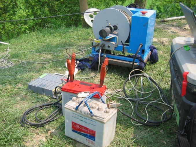
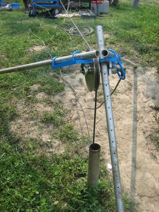
4 Equipment
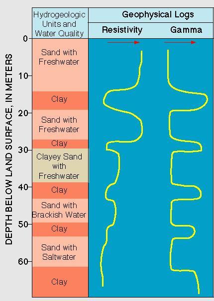
5 Hydrostratigraphy
6 Flowmeter Logging conventional single hole flowmeter logging ambient, pumping or injection conditions vertical or horizontal flow logging cross-hole flowmeter logging pumping or injection conditions discrete interval hydraulic testing pumping or injection conditions discrete interval sampling

7 1. Heat-pulse Flowmeter Flowmeter Tools Measurement at stationary position Activation of heat grid to heat packet of water Movement of heated water packet if flow in well Monitoring difference in T between sensors Measurement of time difference between activation and greatest T measurement Calculation of rate of flow and direction resolution 0.01 to 1.5 gallons/min

8 2. Electromagnetic Flowmeter based on Faraday s law of induction electromagnet generates a magnetic field in hollow cylinder within the tool flow of water (conductor) thorough magnetic field at 90 to the field induces a voltage voltage measured by electrodes within the tool and used to calculate velocity of water through fixed-diameter chamber flow velocity used to calculate volumetric flow measurement while moving or stationary resolution gallons/min

9 2. Spinner or Impeller Flowmeter impeller revolves in response to fluid flow recording of number of impeller revolutions per second and used to calculate fluid velocity measurement while moving or while stationary minimum velocity is ~5 feet/min generally poor resolution
10 Vertical Flowmeter Logging Single hole measurement of vertical movement of fluid in a borehole, produced by difference in hydraulic head between two permeable units measurement of rate and direction of vertical flow relative hydraulic gradients indentify permeable units or fractures Cross-hole identify cross-hole connections transmissivity hydraulic heads storage coefficient of permeable unit or fracture between borehole
11 Single Hole Flowmeter Log fluid moves from higher head to lower head!

12 detection of transmissive zones fracture distribution determined by acoustic televiewer Transmissivity estimated from pumping tests using straddle packer Williams and Conger (1990)

13 Cross-Hole Flowmeter Log Williams and Paillet (1998)
14 Horizontal Flowmeter Logging KVA Heat-Pulse Flowmeter Scanning Colloidal Borescope Flowmeter (LLNL) - evaluates horizontal groundwater flow direction and velocity - employs a charge couple device, magnetometer, light source and remotely controlled focal lens mechanism to track colloid-sized particle Acoustic Doppler Velocimeter (USGS) - position of colloids is measured by acoustic reflections - as colloids move with groundwater, software tracks the particle paths and calculated transport rate and direction - Built-in magnetometer
 http://ny.")
15 Fluid Logging - Temperature used to delineate waterbearing zones identify vertical flow between zones of different hydraulic head flow is indicated by T-grad < regional geothermal gradient used to identify recharge water and liquid waste discharges to the ground convection in well can disturb thermal gradient (deep and large wells)
 is reciprocal of resistivity (10,000 / resistivity) http://ny.water.usgs.")
16 Fluid Logging Fluid Resistivity (ohm-m) used to identify waterbearing zones, vertical flow, contaminants probe measures AC-voltage drop across two closely spaced electrodes -> function of fluid resistivity fluid conductivity (mhos/cm) is reciprocal of resistivity (10,000 / resistivity)
17 Borehole Televiewer Logging used to obtain oriented images from borehole wall two different technologies are available: acoustic televiewer, optical televiewer acoustic televiewer uses an acoustic signal from a rotating sonar transducer optical televiewer uses a high resolution digital color camera with a light source both have a built-in magnetometer to orient the image with respect to magnetic north identify fractures, breakouts and other borehole features


18 Digital Borehole Television Camera commonly used to inspect well casing conditions and screens also used to view: lithologic texture, grain size, color, water levels, fractures applicable in clear water above and below water level built-in magnetometer for oriented 360º digital images of borehole wall
19 Case Study Lamont Test Wells Matter et al. (2006)
20 Matter et al. (2006)

21 Borehole Televiewer Lamont Test Wells
22 Flowmeter Logging Lamont Test Wells Matter et al. (2006)
23 Flowmeter Log Analysis Transmissivity (T) horizontal flow rate per unit width of aquifer under unit head gradient T = K h b, where b is aquifer thickness K h = horizontal hydraulic conductivity (m/s) Cooper and Jacob method (1946) K 1 1/2 Q 2.25K2Ht ln 2 2 H ( p) R S Q: horizontal volumetric flow H: thickness of interval p: change in hydraulic head from static conditions t: time since onset of pumping or injection R: borehole radius S: Storativity (5.5E-05)
24 Permeability Testing Short duration fluid injection tests Flowmeter measurements with electromagnetic flowmeter 48-hour constant discharge pump test
25
26 Pump Test Analysis T (m 2 /day) K (m/day) Sill Contact Zone N.B. Sediments 0.57* *

27 Correlation Optical BHTV
28 Literature Matter, J. M., D. Goldberg, R. H. Morin, and M. Stute, Contact zone permeability at intrusion boundaries: new results from hydraulic testing and geophysical logging in the Newark Rift Basin, New York, USA. Molz, F. J., Morin, R. H., Hess, A. E., Melville, J. G., and Guven, O., 1989, The impeller meter for measuring aquifer permeability variations - Evaluations and comparisons with other tests: Water Resources Research, v. 25, p Molz, F. J. and Melville, J. G., 1996, Discussion of combined use of flowmeter and time-drawdown data to estimate hydraulic conductivities in layered aquifer systems: Ground Water, v. 34, no. 5, p Paillet, F.L., Hess, A.E., Cheng, C.H., and Hardin, E., 1987, Characterization of fracture permeability with highresolution vertical flow measurements during borehole pumping: Ground Water, v. 25, no. 1, p Paillet, F.L., 1998, Flow modeling and permeability estimation using borehole flow logs in heterogeneous fractured formations: Water Resources Research, v. 34, no. 5, p Paillet, F.L., 2000, A field technique for estimating aquifer parameters using flow log data: Ground Water, v. 38, no. 4, p Paillet, F.L., and Reese, R.S., 2000, Integrating borehole logs and aquifer tests in aquifer characterization: Ground Water, v. 38, no. 5, p Paillet, F.L., 2001, Hydraulic head applications of flow logs in the study of heterogeneous aquifers: Ground Water, v. 39, no. 5, p
Measuring Flow Rate in Crystalline Bedrock Wells Using the Dissolved Oxygen Alteration Method
 Methods Note/ Measuring Flow Rate in Crystalline Bedrock Wells Using the Dissolved Oxygen Alteration Method by Sarah A. Vitale 1 and Gary A. Robbins 2 Abstract Determination of vertical flow rates in a
New Geophysical Approaches For Providing Hydrogeologists With What They Need:
 New Geophysical Approaches For Providing Hydrogeologists With What They Need: Fracture Flow, Water Content, Hydaulic Conductivity, Groundwater Discharge and Flow Zones HIGH K and T Paul Bauman, Franklin
Hydrogeologic Characterization. Thomas Doe Winter 2009
 Hydrogeologic Characterization Thomas Doe Winter 2009 What You Need to Know from Previous Lecture Hydrologic Cycle Vadose Zone Specific Yield Capillary pressure Groundwater Flow Systems Confined versus
OUTLINE OF PRESENTATION
 GROUNDWATER?? OUTLINE OF PRESENTATION What is groundwater? Geologic investigation Definitions: aquifer and aquitard, unconfined and semi-confined Water level and interpretation of water level data Well
Exploring Dynamic Interactions Between Surface Water and Groundwater at a Point Bar System in the Muskegon River Watershed
 Exploring Dynamic Interactions Between Surface Water and Groundwater at a Point Bar System in the Muskegon River Watershed Introduction The quality of critical surface water resources is linked to the
AL BAYAN TECHNICAL EQUIPMENT L.L.C are the authorized distributers of Robertson Geologging in GCC.
 From its beginnings in 1979, Robertson Geologging pioneered the development of slim-hole digital borehole logging systems and techniques. Now, as probably the largest global supplier of slim-hole borehole-logging
SOURCES OF WATER SUPPLY GROUND WATER HYDRAULICS
 SOURCES OF WATER SUPPLY GROUND WATER HYDRAULICS, Zerihun Alemayehu GROUNDWATER Groundwater takes 0.6% of the total water in the hydrosphere 0.31% of the total water in the hydrosphere has depth less than
FLOWING FLUID ELECTRICAL CONDUCTIVITY PROFILING AN INVENTIVE AND COST EFFECTIVE ALTERNATIVE TO CONVENTIONAL DOWNHOLE HYDRAULIC PROFILING TECHNIQUES
 FLOWING FLUID ELECTRICAL CONDUCTIVITY PROFILING AN INVENTIVE AND COST EFFECTIVE ALTERNATIVE TO CONVENTIONAL DOWNHOLE HYDRAULIC PROFILING TECHNIQUES Abstract S.D. Mohr 1 and L. Smith 2 1 Environmental Resources
HEAP CHARACTERIZATION AND MONITORING WITH ELECTRICAL RESISTIVITY FOR OPTIMIZING SECONDARY LEACHING
 HEAP CHARACTERIZATION AND MONITORING WITH ELECTRICAL RESISTIVITY FOR OPTIMIZING SECONDARY LEACHING Dale RUCKER and Jim FINK hydrogeophysics, Inc., USA ABSTRACT Electrical resistivity geophysics has been
VERIFICATION OF GEOTECHNICAL GROUTING- STRATEGIES AND PLANNING. Michael J. Byle, D.GE, F. ASCE
 VERIFICATION OF GEOTECHNICAL GROUTING- STRATEGIES AND PLANNING Michael J. Byle, D.GE, F. ASCE Verification of Geotechnical Grouting was published By the ASCE Committee on Grouting in 1995 It is still available
ENGINEERING HYDROLOGY
 ENGINEERING HYDROLOGY Prof. Rajesh Bhagat Asst. Professor Civil Engineering Department Yeshwantrao Chavan College Of Engineering Nagpur B. E. (Civil Engg.) M. Tech. (Enviro. Engg.) GCOE, Amravati VNIT,
HYDROFRACTURING. PRELUDE:
 HYDROFRACTURING. PRELUDE: To tap ground water, the ground water abstracting structures like bore wells/ open wells are drilled / dug. Bore Wells have been regarded as adequate safe source of drinking water.
Assessing Effects of Intraborehole Flow in Deep Monitoring Wells on Estimates of Aquifer Salinity Profiles
 Assessing Effects of Intraborehole Flow in Deep Monitoring Wells on Estimates of Aquifer Salinity Profiles Problem and Research Objectives Regulation of groundwater withdrawals at some aquifer locations
SAMPLING PROTOCOL OPTIMIZATION USING FLUID ELECTRICAL CONDUCTIVITY LOGGING
 SAMPLING PROTOCOL OPTIMIZATION USING FLUID ELECTRICAL CONDUCTIVITY LOGGING C. Lasher 1 and J.M. Nel 2 1 SRK Consulting (Pty) Ltd, The Administration Building, 183 Main Road, Rondebosch, South Africa; email:
Borehole Condition Assessment
 Borehole Condition Assessment The condition of a borehole is paramount to its on going performance. Checks on newly drilled boreholes ensure that design and specification have been met and allow benchmark
Hydrogeophysics: Applications of Geophysical Techniques in Hydrogeological Investigations
 Hydrogeophysics: Applications of Geophysical Techniques in Hydrogeological Investigations Lanbo Liu ( 刘澜波 ) Civil & Environmental Engineering University of Connecticut (Lanbo.Liu@UConn.edu) Tsinghua University,
William Wilmot Matrix Solutions Inc. 118, Avenue S.W., Calgary, Alberta, Canada
 Hydrogeologic Assessment in Support of the Development of the Peace River Oil Sands Deposit: A Case Study Concerning a Pilot-Scale in-situ SAGD Operation William Wilmot Matrix Solutions Inc. 118, 319-2
DESIGN PARAMETERS FOR MULTI-PHASE EXTRACTION SYSTEMS USING UNSATURATED AND SATURATED SOIL PROPERTIES
 DESIGN PARAMETERS FOR MULTI-PHASE EXTRACTION SYSTEMS USING UNSATURATED AND SATURATED SOIL PROPERTIES Todd White, M.Sc., P.Geol. and Douglas A. Sweeney, M.Sc., P.Eng. SEACOR Environmental Inc. INTRODUCTION
PERFORMANCE AND INTERPRETATION OF A TRACER TEST IN THE BELGIAN COASTAL PLAIN
 17 th Salt Water Intrusion Meeting, Delft, The Netherlands, 6-10 May 2002 275 PERFORMANCE AND INTERPRETATION OF A TRACER TEST IN THE BELGIAN COASTAL PLAIN Alexander VANDENBOHEDE and Luc LEBBE Department
BOREHOLE CONDITION ASSESSMENT
 BOREHOLE CONDITION ASSESSMENT The condition of a borehole is paramount to its on going performance. Checks on newly drilled boreholes ensure that design and specification have been met and allow benchmark
University of Arizona Department of Hydrology and Water Resources Dr. Marek Zreda
 University of Arizona Department of Hydrology and Water Resources Dr. Marek Zreda HWR431/531 - Hydrogeology Final exam - 12 May 1997 Open books and notes The test contains 8 problems on 7 pages. Read the
Nuclear Magnetic Resonance (NMR):
:") Nuclear Magnetic Resonance (): An Emerging for Aquifer Characterization in Water Resource Applications Presented by: Lauren Handley, R.G. Senior Hydrogeologist Lauren.handley@lrewater.com 1 for Water Resource
Nuclear Magnetic Resonance (): An Emerging for Aquifer Characterization in Water Resource Applications Presented by: Lauren Handley, R.G. Senior Hydrogeologist Lauren.handley@lrewater.com 1 for Water Resource
Characterization and Remediation of Diesel in a Fractured Rock Aquifer with a Nutrient-Flushing System
 Characterization and Remediation of Diesel in a Fractured Rock Aquifer with a Nutrient-Flushing System Presentation by David Thomson and Stefan Humphries 31-Oct-07 Authors and Collaborators Presenting
Analysis of Sedimentary Geothermal Systems Using an Analytical Reservoir Model
 GRC Transactions, Vol. 38, 2014 Analysis of Sedimentary Geothermal Systems Using an Analytical Reservoir Model Chad Augustine National Renewable Energy Laboratory Keywords Sedimentary geothermal, reservoir
SEES 503 SUSTAINABLE WATER RESOURCES GROUNDWATER. Instructor. Assist. Prof. Dr. Bertuğ Akıntuğ
 SEES 503 SUSTAINABLE WATER RESOURCES GROUNDWATER Instructor Assist. Prof. Dr. Bertuğ Akıntuğ Civil Engineering Program Middle East Technical University Northern Cyprus Campus SEES 503 Sustainable Water
WaterTech Brent Morin, B.Sc., P.Geol. Waterline Resources Inc.
 WaterTech 2017 Brent Morin, B.Sc., P.Geol. Waterline Resources Inc. Conceptual Hydrogeological Model (CHM) Well Completion Aquifer Testing Data Collection and Preparation Aquifer Test Analysis and Interpretation
Westbay System. Multilevel Technology for Subsurface Characterization and Monitoring
 Westbay System Multilevel Technology for Subsurface Characterization and Monitoring Is Groundwater Monitoring Important? WHY GROUNDWATER MONITORING? Groundwater is an essential resource of great social,
Name: Problem 1. (30 points; 5 each)
") 2700 2500 1900 2100 1500 2300 1800 1700 Hydrogeology - HWR/GEOS 431/531 Final exam Dr. Marek Zreda 16 December 1998 11:00-1:00 Open books and notes There are 5 problems on 7 pages. Read entire test before
2700 2500 1900 2100 1500 2300 1800 1700 Hydrogeology - HWR/GEOS 431/531 Final exam Dr. Marek Zreda 16 December 1998 11:00-1:00 Open books and notes There are 5 problems on 7 pages. Read entire test before
REPRESENTING HYDRODYNAMIC DISPERSION IN SALTWATER INTRUSION MODELS THAT DIFFER IN TEMPORAL RESOLUTION. Alyssa Dausman 1 and Christian Langevin 1
 REPRESENTING HYDRODYNAMIC DISPERSION IN SALTWATER INTRUSION MODELS THAT DIFFER IN TEMPORAL RESOLUTION Alyssa Dausman 1 and Christian Langevin 1 ABSTRACT: Variable-density groundwater flow models are often
GAMMA RAY AND SPONTANEOUS POTENTIAL LOGGING CORE COPYRIGHT. Introduction. By the end of this lesson, you will be able to:
 LEARNING OBJECTIVES GAMMA RAY AND SPONTANEOUS POTENTIAL LOGGING CORE By the end of this lesson, you will be able to: Identify three or more ways to convey openhole logging tools into the borehole, and
Well Hydraulics. The time required to reach steady state depends on S(torativity) T(ransmissivity) BC(boundary conditions) and Q(pumping rate).
 T(ransmissivity) BC(boundary conditions) and Q(pumping rate).") Well Hydraulics The time required to reach steady state depends on S(torativity) T(ransmissivity) BC(boundary conditions) and Q(pumping rate). cone of depression static water level (SWL) drawdown residual
Well Hydraulics The time required to reach steady state depends on S(torativity) T(ransmissivity) BC(boundary conditions) and Q(pumping rate). cone of depression static water level (SWL) drawdown residual
Delineating the saltwater wedge in two carbonate aquifers in Mallorca (Spain) N. Van Meir, M. Herfort, D. Jaeggi. S.
 N. Van Meir, M. Herfort, D. Jaeggi. S.") The Second International Conference on Saltwater Intrusion and Coastal Aquifers Monitoring, Modeling, and Management. Mérida, Yucatán, México, March - April 2, 3 Delineating the saltwater wedge in two
The Second International Conference on Saltwater Intrusion and Coastal Aquifers Monitoring, Modeling, and Management. Mérida, Yucatán, México, March - April 2, 3 Delineating the saltwater wedge in two
Exploring Design, Technology, & Engineering Chapter 21 Energy-Conversion Technology
 Exploring Design, Technology, & Engineering 2012 Chapter 21 Energy-Conversion Technology Tools: Printer (color optional) 8.5 x 11 paper Scissors Directions: 1. Print 2. Fold paper in half vertically 3.
D.G.S.W. Pitakumbura Manager (Groundwater Studies) Groundwater Section NWS&DB. Groundwater recharge or deep drainage or
 Groundwater Section NWS&DB. Groundwater recharge or deep drainage or") Groundwater Recharge and Extraction Techniques D.G.S.W. Pitakumbura Manager (Groundwater Studies) Groundwater Section NWS&DB What is Groundwater Recharge Groundwater recharge or deep drainage or deep percolation
Groundwater Recharge and Extraction Techniques D.G.S.W. Pitakumbura Manager (Groundwater Studies) Groundwater Section NWS&DB What is Groundwater Recharge Groundwater recharge or deep drainage or deep percolation
The Use of Advanced Downhole Geophysical Tools for Detailed Aquifer Characterization. By Shawky, I., Labaky, W. and Delhomme, J.P.
 The Use of Advanced Downhole Geophysical Tools for Detailed Aquifer Characterization Abstract By Shawky, I., Labaky, W. and Delhomme, J.P. Aquifer storage and recovery (ASR), passive groundwater remediation
Lecture Notes on Groundwater Hydrology. Part 1
 Lecture Notes on Groundwater Hydrology Part 1 1 1. Basic concepts and definitions 1.1 Aquifer, Aquitard, Aquiclude and Aquifuge Aquifer is a word produced from two Latin words: Aqua, which means water
9/9/ Basic Types of Rocks. Porosity of Earth Materials
 3 Basic Types of Rocks Porosity of Earth Materials Igneous rocks: crystalline solids which form directly from the cooling of magma. Example: granite. Sedimentary rocks: formed from material deposited as
CMYK. Pantone. Westbay System. Greyscale. Black on White. White on Black. Multi-level Technology for Subsurface Characterization and Monitoring
 CMYK Pantone Westbay System Greyscale Black on White White on Black Multi-level Technology for Subsurface Characterization and Monitoring Is Groundwater Monitoring Important? WHY GROUNDWATER MONITORING?
*** IN THE PUMPING WELL
 Specific Capacity = discharge rate/max drawdown after pumping at a constant, known rate for a time until apparent equilibrium is reached (i.e., minimal change in drawdown with time) Theis et al, 1963 -
4. Groundwater Resources
 4. Groundwater Resources 4-1 Majority (97 %) of unfrozen fresh water on earth exists as groundwater. In comparison to surface water, - groundwater is available all year around - groundwater is mostly invisible
GEOTHERMAL HEAT PUMPS CONFIGURATIONS/INSTALLATION
 GEOTHERMAL HEAT PUMPS CONFIGURATIONS/INSTALLATION There are three main categories when dealing with geothermal heat pumps; open-loop, closed-loop, and direct-exchange. The closed-loop and direct-exchange
CONCENTRATE AND BRINE MANAGEMENT THROUGH DEEP WELL INJECTION. Abstract
 CONCENTRATE AND BRINE MANAGEMENT THROUGH DEEP WELL INJECTION M.S. Bruno and J. Couture, GeoEnvironment Technologies LLC J.T. Young, Terralog Technologies USA, Inc. Abstract The Reverse Osmosis (RO) process
Aquifer Science Staff, January 2007
 Guidelines for Hydrogeologic Reports and Aquifer Tests Conducted Within the Jurisdictional Boundaries of the Barton Springs / Edwards Aquifer Conservation District I. Introduction Aquifer Science Staff,
Part 1: Steady Radial Flow Questions
 Islamic University of Gaza Water Resources Management EENV 4359 First Semester (2014-2015) Instructors: Dr. Yunes Mogheir Eng. Wael Salem Eng. Israa Abushaban Question 1 (text book) Part 1: Steady Radial
POROSITY, SPECIFIC YIELD & SPECIFIC RETENTION. Physical properties of
 POROSITY, SPECIFIC YIELD & SPECIFIC RETENTION Porosity is the the ratio of the voids to the total volume of an unconsolidated or consolidated material. Physical properties of n = porosity as a decimal
Characterization of Deep Groundwater: A Conference Report. William M. Alley, Michael Wireman, Mary Musick 2014 GWPC Annual Forum
 Characterization of Deep Groundwater: A Conference Report William M. Alley, Michael Wireman, Mary Musick 2014 GWPC Annual Forum Topical Discussions Analysis of data and information to characterize hydrogeologic
TAKING CLOSED PIPING FLOWMETERS TO THE NEXT LEVEL NEW TECHNOLOGIES SUPPORT TRENDS IN DATA LOGGING AND SCADA SYSTEMS
 TAKING CLOSED PIPING FLOWMETERS TO THE NEXT LEVEL NEW TECHNOLOGIES SUPPORT TRENDS IN DATA LOGGING AND SCADA SYSTEMS Michael Kohlmann 1 Peter Miramontes 2 ABSTRACT We are seeing some clear trends in water
Lab 6 - Pumping Test. Pumping Test. Laboratory 6 HWR 431/
 Pumping Test Laboratory 6 HWR 431/531 7-1 Introduction: Aquifer tests are performed to evaluate the capacity of an aquifer to meet municipal or industrial water requirements. Hydraulic characteristics
WSRC-TR Electromagnetic Borehole Flowmeter (EBF) Testing in R-area (U)
 Testing in R-area (U)") WSRC-TR-2000-00170 Electromagnetic Borehole Flowmeter (EBF) Testing in R-area (U) Westinghouse Savannah River Company Savannah River Site Aiken, SC 29808 This document was prepared in conjunction with
WSRC-TR-2000-00170 Electromagnetic Borehole Flowmeter (EBF) Testing in R-area (U) Westinghouse Savannah River Company Savannah River Site Aiken, SC 29808 This document was prepared in conjunction with
3/7/ Basic Types of Rocks. A Brief Review of Physics
 A Brief Review of Physics Energy is the capacity to do work. Work is equal to the product of the net force applied to a fluid and the distance through which the force moves: W = F l W is work [M 2 T -2
Geophysics as an Integral Part of the ASR Process
 Geophysics as an Integral Part of the ASR Process Thomas L. Dobecki, Ph.D., P.G., SDII Global Corporation, Tampa, Florida Jennifer L. Hare, Ph.D., Zonge Engineering & Research Organization, Tucson, Arizona
Prepared by Jean Paré, P. Eng. Chemco Inc.
 Tools and Methods to Reduce and Control Uncertainties Associated with the Use of In Situ Remediation Techniques (Chemical Oxidation) for Organic Contaminants in Soil and Groundwater Remtech 2010 Banff,
Hydrogeologic Characterization Methods Used in Karst: A Contrast to the Darcian Aquifer Model
 Aquifer Characterization Groundwater Behavior in the Subsurface Environment Kentucky Section - American Institute of Professional Geologists Lexington, KY, May 29, 2014 Hydrogeologic Characterization Methods
Supplemental Guide II-Delineations
 Supplemental Guide II-Delineations Contents Source Water Protection Area Delineation... 1 Delineation Criteria for Systems Using Groundwater Sources... 2 Time of Travel... 4 Flow Boundaries... 4 Delineation
Civil Engineering Department College of Engineering
 Civil Engineering Department College of Engineering Course: Soil Mechanics (CE 359) Lecturer: Dr. Frederick Owusu-Nimo What is permeability? A measure of how easily a fluid (e.g., water) can pass through
Pilgrim Hot Springs Geothermal. Resource Exploration
 Pilgrim Hot Springs Geothermal Pilgrim Hot Springs Geothermal Resource Exploration Resource Exploration Testing an innovative remote sensing exploration technique designed to reduce exploration costs Project
THE INFLUENCE OF VARYING COMPOSITION OF SOIL SAMPLES ON WATER FLOW RATE (2MM SHARP SAND 1MM MEDIUM SAND)
") Solid Earth and Space Physics (218) 1: 1-11 Clausius Scientific Press, Canada THE INFLUENCE OF VARYING COMPOSITION OF SOIL SAMPLES ON WATER FLOW RATE (2MM SHARP SAND 1MM MEDIUM SAND) Edeye Ejaita Physics
Solid Earth and Space Physics (218) 1: 1-11 Clausius Scientific Press, Canada THE INFLUENCE OF VARYING COMPOSITION OF SOIL SAMPLES ON WATER FLOW RATE (2MM SHARP SAND 1MM MEDIUM SAND) Edeye Ejaita Physics
Analysis of Vertical Flow During Ambient and Pumped Conditions in Four Monitoring Wells at the Pantex Plant, Carson County, Texas, July September 2008
 In cooperation with the U.S. Department of Energy/National Nuclear Security Administration and Babcock & Wilcox Technical Services Pantex, LLC Analysis of Vertical Flow During Ambient and Pumped Conditions
TEST PLAN. Constant Head Saturated Hydraulic Conductivity Measurements on Repacked Core Samples
 NYE COUNTY NUCLEAR WASTE REPOSITORY PROJECT OFFICE TEST PLAN TITLE: Constant Head Saturated Hydraulic Conductivity Measurements on Repacked Core Samples REVISION: 0 DATE: 4-1-04 PAGE: 1 of 8 TEST PLAN
DEVELOPMENT OF AQUIFER TESTING PLANS. Brent Bauman, P.G. / Erin Lynam, Aquatic Biologist
 DEVELOPMENT OF AQUIFER TESTING PLANS Brent Bauman, P.G. / Erin Lynam, Aquatic Biologist DEVELOPMENT OF AQUIFER TESTING PLANS Goals of Aquifer Testing What questions are we trying to answer Staff review
Use of geophysical methods in investigating PRBs employing non-conductive reactive materials
 Water Resources Management IV 345 Use of geophysical methods in investigating PRBs employing non-conductive reactive materials Y. S. Kim, J. J. Kim, G. H. Lee & J. B. Park School of Civil, Urban and Geosystem
Groundwater. Groundwater Movement. Groundwater Movement Recharge: the infiltration of water into any subsurface formation.
 On March 22, 2014, a major landslide occurred near Oso, Washington. Death toll currently at 30, with 15 still missing. Groundwater Before and After Swipe http://bit.ly/pen1jt N. Fork Stillaguamish River
Dissolved Oxygen Alteration Method for Fractured Bedrock Wellbore Characterization
 Dissolved Oxygen Alteration Method for Fractured Bedrock Wellbore Characterization Gary Robbins and Sarah Vitale Dept. of Natural Resources and the Environment Center for Integrative Geoscience University
Lecture 20: Groundwater Introduction
 Lecture 20: Groundwater Introduction Key Questions for Groundwater 1. What is an aquifer? 2. What is an unconfined aquifer? 3. What is groundwater recharge? 4. What is porosity? What determines the magnitude
INCORPORATION OF GROUNDWATER FLOW INTO NUMERICAL MODELS AND DESIGN MODELS
 INCORPORATION OF GROUNDWATER FLOW INTO NUMERICAL MODELS AND DESIGN MODELS Jeffrey D. Spitler, Ph.D., P.E., Simon J. Rees, Ph.D., and Andrew D. Chiasson Oklahoma State University School of Mechanical and
Potential effects evaluation of dewatering an underground mine on surface water and groundwater located in a rural area
 Potential effects evaluation of dewatering an underground mine on surface water and groundwater located in a rural area ITRODUCTIO Michel Mailloux* Eng. M.Sc, Vincent Boisvert, M.Sc, Denis Millette, Eng.,
Lesson 2 - Stationary Sensors (Part 2)
") Lesson 2 - Stationary Sensors (Part 2) Water pressure, hydraulics, and other water storages (soil, snow ) The meteorology sensors (precipitation) are important because they tell us how much water our climate
Lesson 2 - Stationary Sensors (Part 2) Water pressure, hydraulics, and other water storages (soil, snow ) The meteorology sensors (precipitation) are important because they tell us how much water our climate
Simulation of Pumping Induced Groundwater Flow in Unconfined Aquifer Using Arbitrary Lagrangian-Eulerian Method
 Simulation of Pumping Induced Groundwater Flow in Unconfined Aquifer Using Arbitrary Lagrangian-Eulerian Method Y. Jin *1, E. Holzbecher 1, and S. Ebneth 2 1 Applied Geology, Geoscience Centre, Georg-August-University
Springshed Management Training Curriculum 2016 The Springs Initiative
 Springshed Management Training Curriculum 2016 The Springs Initiative SESSION TITLE: Aquifers SECTION: Understanding the Resource MODULE: II. Applied Hydrogeology AUTHORS: Dr Himanshu Kulkarni CONTRIBUTING
Module 2. The Science of Surface and Ground Water. Version 2 CE IIT, Kharagpur
 Module 2 The Science of Surface and Ground Water Lesson 7 Well Hydraulics Instructional Objectives At the end of this lesson, the student shall be able to learn the following: 1. The concepts of steady
Simulation of horizontal well performance using Visual MODFLOW
 Environ Earth Sci (2013) 68:1119 1126 DOI 10.1007/s12665-012-1813-x ORIGINAL ARTICLE Simulation of horizontal well performance using Visual MODFLOW Wan Mohd Zamri W. Ismail Ismail Yusoff Bahaa-eldin E.
Standard Test Method for Determining Transmissivity and Storativity of Low Permeability Rocks by In Situ Measurements Using Pressure Pulse Technique 1
 Designation: D 4631 95 (Reapproved 2000) Standard Test Method for Determining Transmissivity and Storativity of Low Permeability Rocks by In Situ Measurements Using Pressure Pulse Technique 1 This standard
[ ] (6) The tidal correction procedure is repeated for all segments of the tidal and groundwater drawdown record.
![[ ] (6) The tidal correction procedure is repeated for all segments of the tidal and groundwater drawdown record.](/thumbs/85/92772646.jpg "[ ] (6) The tidal correction procedure is repeated for all segments of the tidal and groundwater drawdown record.") (also Table 5-1) to correct each segment of observed groundwater drawdown using the equation: [ ] s' ( τ ) = s( τ) s( 0) E H( 0) 0 H( τ) + s'( 0) (5-15) where s0(τ) = Corrected groundwater drawdown for
(also Table 5-1) to correct each segment of observed groundwater drawdown using the equation: [ ] s' ( τ ) = s( τ) s( 0) E H( 0) 0 H( τ) + s'( 0) (5-15) where s0(τ) = Corrected groundwater drawdown for
Storage and Flow of Groundwater
 Storage and Flow of Groundwater Aquifer AQUIFER (in Greek)= AQUA (water) + FERRE (to bear) Aquifer- a saturated geological formation which will yield sufficient quantity of water to wells and springs Underground
Recharge Lake/Wetland: Generalized Monitoring Strategy
 General Hydrologic Characteristics of Recharge Lakes & Wetlands The primary sources of water for recharge lakes and wetlands are direct precipitation and surface runoff. The lake stage of a recharge lake
Groundwater Modeling Guidance
 Groundwater Modeling Guidance Richard J. Mandle Groundwater Modeling Program Michigan Department of Environmental Quality Draft 1.0 10/16/02 Executive Summary The use of groundwater models is prevalent
Ground Water and Wells. Basic (Geo)Science for Sustainable a Future. Dr. David Boutt. UMass Amherst, Geosciences Department
Science for Sustainable a Future. Dr. David Boutt. UMass Amherst, Geosciences Department") Ground Water and Wells Basic (Geo)Science for Sustainable a Future Dr. David Boutt UMass Amherst, Geosciences Department Your tasked with locating properties/land to purchase for a high yield (1000 gpm)
Ground Water and Wells Basic (Geo)Science for Sustainable a Future Dr. David Boutt UMass Amherst, Geosciences Department Your tasked with locating properties/land to purchase for a high yield (1000 gpm)
Monitoring Wells North of the Mine Site: Installation and Hydrogeologic Monitoring Plan
 Monitoring Wells North of the Mine Site: Installation and Hydrogeologic Monitoring Plan NorthMet Project Prepared for Poly Met Mining Inc October 2016 4300 MarketPointe Drive, Suite 200 Minneapolis, MN
New Method for Continuous Transmissivity Profiling in Fractured Rock
 New Method for Continuous Transmissivity Profiling in Fractured Rock by Carl E. Keller 1, John A. Cherry 2, and Beth L. Parker 3 Abstract A new method is presented to search for hydraulically transmissive
Performance and Analysis of Aquifer Slug Tests and Pumping Tests Policy
 Performance and Analysis of Aquifer Slug Tests and Pumping Tests Policy May 31, 2007 Table of Contents page Introduction... 2 (1) Purpose of policy...2 (2) Basis for technical approach...2 (3) The purpose
Acoustics and Ultrasonics for Downhole Oil and Gas Logging
 Acoustics and Ultrasonics for Downhole Oil and Gas Logging Eric Molz MSS Piezo Technologies 2015 Meggitt PLC. Presentation Roadmap Method of Well Drilling Method of Well Completion Questions Sonic Formation
3. FIELD INVESTIGATION PROGRAM
 Department of Public Works U.S. Army Corps of Engineers Phase 1B Geotechnical Investigation Geotechnical Data Report 3.3 FIELD METHODS AND PROCEDURES 3. FIELD INVESTIGATION PROGRAM The borings were advanced
To Study the Electrical Resistivity of Deccan Traps at Ranga-Reddy District
 To Study the Electrical Resistivity of Deccan Traps at Ranga-Reddy District Shaik Abdul Waheed 1 ; Syed Mansoor Ali 1 ; Mohammed Ayaz 1 ; Shaik Abdul Wahed 1 ; Srikanth 2 & Rajesh Kanna 3,* 1 Undergraduate
Lecture 2: Soil Properties and Groundwater Flow
 9621 Soil Remediation Engineering Lecture 2: Soil Properties and Groundwater Flow Spring 2012 Faculty of Engineering & Applied Science 1 2.1 Soil properties 2.1.1 What is soil? Each discipline defines
CHAPTER 4: Risk Assessment Risk in Groundwater Contamination
 CHAPTER 4: Risk Assessment Risk in Groundwater Contamination Instructor: Dr. Yunes Mogheir -١ Introduction: Water pollution is nowadays one of the most crucial environmental problems world-wide. Pollution
Groundwater. Chapter 10 11/22/2011. I. Importance of groundwater
 Groundwater Chapter 10 I. Importance of groundwater A. Groundwater is water found in the pores of soil and sediment, plus narrow fractures in bedrock B. Where is fresh water - 2 % of all water is fresh
ALABAMA GROUNDWATER SUSTAINABILITY: A STRONG SCIENTIFIC FOUNDATION FOR WATER RESOURCE MANAGEMENT AND POLICY TO SECURE ALABAMA S WATER FUTURE
 ALABAMA GROUNDWATER SUSTAINABILITY: A STRONG SCIENTIFIC FOUNDATION FOR WATER RESOURCE MANAGEMENT AND POLICY TO SECURE ALABAMA S WATER FUTURE Marlon Cook Geological Survey of Alabama Groundwater Assessment
Aquifer Airlift Testing
 Presentation for the CWWCA Annual Meeting 2008 by Hank Baski Colorado Springs January 12, 2008 Overview Ground Water: Fallacies & Forecasts Commonly believed fallacies hinder optimal development of water
Amah E. A 1, Anam G. S 1 1 Department of Geology, University of Calabar, Calabar, Nigeria
 IOSR Journal of Applied Geology and Geophysics (IOSR-JAGG) e-issn: 2321 0990, p-issn: 2321 0982.Volume 4, Issue 1 Ver. I (Jan. - Feb. 2016), PP 01-08 www.iosrjournals.org Determination of Aquifer Hydraulic
Hydrogeology Laboratory Semester Project: Hydrogeologic Assessment for CenTex Water Supply, Inc.
 Hydrogeology Laboratory Semester Project: Hydrogeologic Assessment for CenTex Water Supply, Inc. Matthew M. Uliana, Ph.D. Department of Biology Geology Program and Aquatic Resources Texas State University
CHAPTER 5 WELL CONSTRUCTION
 CHAPTER 5 WELL CONSTRUCTION Wells Shallow ( < 15 meters) Deep ( > 15 meters) Shallow Wells Include Dug wells Kanats Vertical wells Horizontal wells They are drilled by: digging, boring, driving, and jetting
A new method in determining bulk hydraulic conductivity of mangrove forest sediment
 River Basin Management III 65 A new method in determining bulk hydraulic conductivity of mangrove forest sediment A. Susilo Geophysics Laboratory, Physics Department, Brawijaya University, Indonesia Abstract
15A NCAC 02C.0219 AQUIFER STORAGE AND RECOVERY WELLS (a) Aquifer Storage and Recovery Wells are used to inject potable water for the purposes of
 Aquifer Storage and Recovery Wells are used to inject potable water for the purposes of") 15A NCAC 02C.0219 AQUIFER STORAGE AND RECOVERY WELLS (a) Aquifer Storage and Recovery Wells are used to inject potable water for the purposes of subsurface storage and for later recovery of the injected
15A NCAC 02C.0219 AQUIFER STORAGE AND RECOVERY WELLS (a) Aquifer Storage and Recovery Wells are used to inject potable water for the purposes of subsurface storage and for later recovery of the injected
Soil Temperature Monitoring and Study of Geothermal Heat Pump Systems
 Proceedings World Geothermal Congress 2015 Melbourne, Australia, 19-25 April 2015 Soil Temperature Monitoring and Study of Geothermal Heat Pump Systems Du Jizhong, Yang Ze, and Yu Huiming No.280, Huanghe
Report on Effects of Groundwater Withdrawal from the Doghouse Meadow, Yosemite National Park
 Report on Effects of Groundwater Withdrawal from the Doghouse Meadow, Yosemite National Park William E. Sanford Department of Geosciences Colorado State University 03 March 2006 1 Purpose The purpose of
Permeability, Flow Rate, and Hydraulic Conductivity Determination for Variant Pressures and Grain Size Distributions
 Permeability, Flow Rate, and Hydraulic Conductivity Determination for Variant Pressures and Grain Size Distributions Nick Desiderio, npd5050@psu.edu, February 18, 2014 Abstract Carbon capture and storage
Influence of purging the surrounding monitoring wells for groundwater sampling during a hydraulic conductivity test in a monitoring well.
 Influence of purging the surrounding monitoring wells for groundwater sampling during a hydraulic conductivity test in a monitoring well. Hafeez Chishti, Ph.D., P.Geol. PHH ARC Environmental 1 SLUG TEST
A Physical Model Hole Experiment for Determining Hydraulic Constants in Boreholes using an Electrical Conductivity Log Technique.
 A Physical Model Hole Experiment for Determining Hydraulic Constants in Boreholes using an Electrical Conductivity Log Technique. Yeonghwa Kim * and Huntae Lim * * Department of Geophysics, Kangwon National
Simulations to Verify Horizontal Flow Measurements from a Borehole Flowmeter
 Simulations to Verify Horizontal Flow Measurements from a Borehole Flowmeter by Scott C. James 1,RichardA.Jepsen 2,RichardL.Beauheim 3, William H. Pedler 4, and Wayne A. Mandell 5 Abstract This paper reports
WM2012 Conference, February 26 March 1, 2012, Phoenix, Arizona, USA
 3D Characterization and Time-Lapse Imaging of the Desiccation Treatability Test at the Hanford BC-Cribs and Trenches Site using High Performance Computing applied to Electrical Resistivity Imaging 12271