Hydrogeology Laboratory Semester Project: Hydrogeologic Assessment for CenTex Water Supply, Inc.
|
|
|
- Shanon Barnett
- 6 years ago
- Views:
Transcription

1 Hydrogeology Laboratory Semester Project: Hydrogeologic Assessment for CenTex Water Supply, Inc. Matthew M. Uliana, Ph.D. Department of Biology Geology Program and Aquatic Resources Texas State University 601 University Drive San Marcos, TX Introduction A typical undergraduate hydrogeology class has an associated lab section that covers basic hydrogeology concepts, such as porosity, permeability, aquifer testing, hydrogeologic maps, and groundwater modeling. These concepts are generally presented as a series of independent exercises, with one week devoted to porosity, one to permeability, one to hydraulic gradient, etc. The problem with this mode of presentation is that most students fail to see the connections between the concepts, the applied use of the skills related to the concepts, and the general reason for leaning the material at all. The result is that students generally walk away from the course with little retention of the concepts and associated skills and little appreciation for how the material may be useful to them in their careers. A way to address this problem is through the use of a semester-long project that is presented to the students in the lab sections as a series of exercises that are all applied towards a single project similar to a major project that a hydrogeologist might undertake as a private consultant. Using this format, the individual lab exercises are all presented within the context of a larger project, and the students benefit by seeing how each concept and the skills associated with that concept are used in a real-world setting. In addition, students get an idea of what the consulting world is like, and they receive important experience with technical writing and preparing technical reports. The project presented here is based on a real project performed by the author for a private consulting firm; however, the project location, company names, maps of property boundaries, and some of the data were changed or fabricated for this exercise. This project involves a hydrogeologic assessment of a property for the purpose of determining potential water well yields for future development. The steps incorporated in the project include determination of basic parameters (porosity, storage, permeability), development of a groundwater map, analysis of aquifer test data, development of an analytical model for estimating drawdowns, and preparation of a technical report. This project can be modified in many ways to enhance the experience of the students. Other steps can be added to the project to cover other concepts, such as contaminant transport, numerical groundwater modeling, aquifer recharge, and subsidence. In addition, although all data is provided for the students, actual hand-on laboratory exercises (grain size analysis, permeameter measurements) can be used so that the students can collect their own data. Please note that this exercise does not necessarily reflect the true groundwater or geologic conditions in the study area, and the data included here should not be used to actually evaluate groundwater resources in Central Texas.
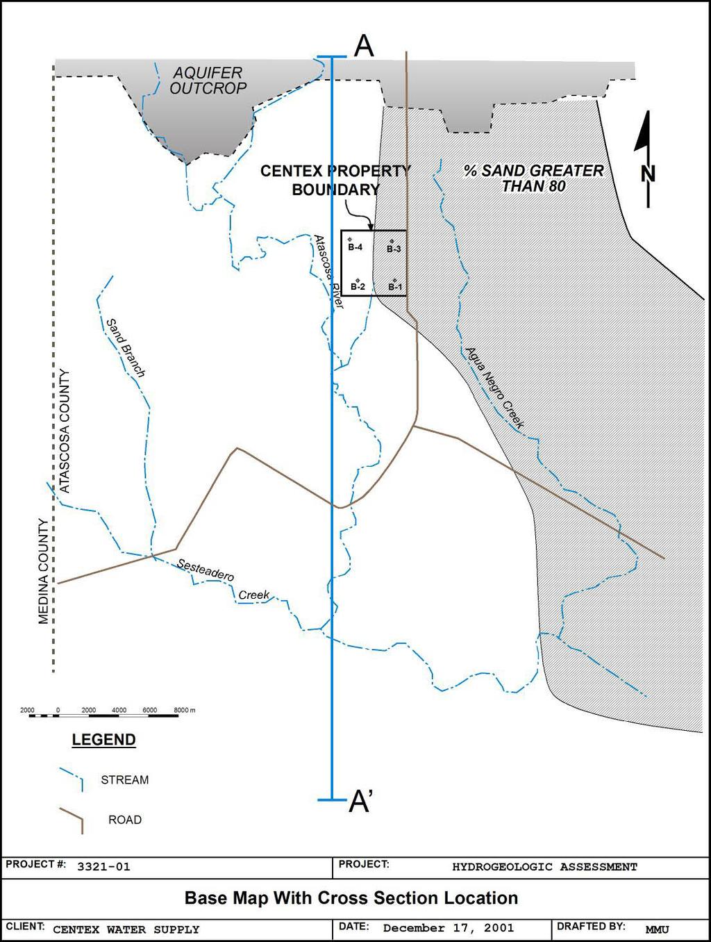
2 Project Description and Background Information CenTex Water Supply, Inc. is a privately owned water supply company in Atascosa County, Texas, that supplies water to several small municipalities near the city of San Antonio. They currently get their water from a reservoir on a local river; however, demand on their supply system is increasing rapidly, and they need to investigate other sources of water, including groundwater. CenTex currently owns a tract of ranch land in Atascosa County. They would like to put wells on the land and use the well water to supplement their surface water supply. However, before they invest in wells and a delivery system, they want to have some idea of how much water the property will yield. They have contracted you assess the property and give them some idea of the potential yield of their wells. So the basic problem that you, the hydrogeologist, has to solve is this: How much water can be pumped out of the ground, on this property, at a sustained rate, over the next 50 years without causing an adverse impact on the aquifer surrounding the property? Throughout the semester, the students are given a series of problem sets that contain some part of this project. For example, the first problem set provides sediment and grain size data from the project area, which will be used to calculate porosities, densities, and grain-size distributions. Later problems sets will involve determination of other hydraulic parameters, development of maps, etc. Each student will start an on-going file of all information related to the project, including the results of the individual problem sets. Problem set results and data will, in some cases, be incorporated into later labs and will end up being a part of the final hydrogeologic assessment report. Copies of all digital files should be placed on some on-line system (Blackboard site, website, etc.) for distribution to the students. Each student will obtain these files and use them to develop an Excel workbook that contains all of the data and calculation results. This workbook will be submitted to the professor via for grading whenever individual problem sets are due. The final steps in the project will involve the development of an analytical groundwater model, using Excel, that will simulate pumping rates and water levels at the end of the 50-year period. Adverse impact to surrounding properties will be defined as 10 meters of drawdown at the property boundary and 2.5 meters of drawdown at any off-site well. This model will be used to determine the pumping rate that will not cause an adverse impact after 50 years. At the end of the semester, each student will prepare a technical report, complete with figures and tables of data, which summarizes their results and gives their recommendation concerning the 50-year groundwater yield. Schedule of Problem Sets Associated with the CenTex Project The following is a list of the problem sets that apply to the CenTex Project. More information on each problem set is included in the supplemental file called < CenTex_LabProject(Uliana) Methods&Appendix.pdf >. Part 1: Porosity and Grain Size Analysis Project introduction and basic background information. Grain size analysis from project samples; estimate porosity of samples and determine grain size distributions. Part 2: Permeability Analysis Using the grain size data, estimate permeability of the sediments. Also, calculate permeabilities from permeameter data. 2
3 Part 3: Groundwater Map Plot groundwater elevations on a base map of the site. Use these data to construct a groundwater contour map. Part 4: Aquifer Tests Data from multi-well pump tests will be used to calculate transmissivity (T) and storativity (S) for the study area, as well as K and specific storage (Ss) (using the saturated thickness of the aquifer). Part 5: Analytical Modeling Develop an analytical model using a spreadsheet program (e.g. MS Excel) and the Theis equation. Calculate drawdowns at various distances from the property, and use the model to answer the primary question. Part 6: Preparation of Final Report Put results together into a final report that includes maps, figures, background information, and tables of results. A site map, cross-section, and basic instructions for each part are given on the following pages. Format instructions for the final report, and a grading form, are also included. Maps, figures, data, procedures, and methods for all assignments are described in a separate file called < CenTex_LabProject(Uliana) Methods&Appendix.pdf >. An optional MS Excel tutorial exercise is also included in this file. References Domenico, P.A., and Schwartz, F.W., 1998 Physical and Chemical Hydrogeology, 2 nd Ed., New York, John Wiley & Sons, 506 pp. Fetter, C.W., Applied Hydrogeology, 4 th Ed., Upper Saddle River, New Jersey; Prentice Hall, 598 pp. 3
4 4
5 5
6 Part 1: Geotechnical Analysis of Aquifer Samples Four test holes were bored in the project area and samples of the aquifer sediments were taken from each. The samples were taken from the saturated part of the aquifer. The saturated samples were weighed, allowed to drain by gravity, weighed again, dried in the oven overnight, then weighed a third time. The dried samples were sieved through #4, 10, 20, 60, 100, and 200 sieves. The sample weights and volumes, and the grain size analysis data, are on the attached pages. The sample weights include the sample can, so you will have to subtract the can weight before doing any further calculations. Then, use the data, and the worksheets associated, to calculate the following parameters Saturated bulk density Dry bulk density Porosity Gravity drained moisture content (gravimetric and volumetric) Degree of saturation (gravity drained sample) Specific Yield and Specific Retention and develop grain-size distribution curves based on the sieve analysis. Part 2: Aquifer Permeability Estimation Permeability is an important parameter that you will need to construct a model of the study area and calculate well yields for the final parts of the project. In this part of the project, we will estimate hydraulic conductivities of the sediments that make up the aquifer. We will use two basic methods for calculating hydraulic conductivity: - empirical equations based on the grain size distribution of samples of the aquifer materials - data from constant or falling head permeameter tests Your assignment is as follows: 1. Use the porosity and grain-size distribution data from the four samples (B-1, B-2, B-3, and B-4) from the porosity lab for the empirical equations. Calculate K using the methods of Hazen (1911) Shepherd (1989) The methods are described in the separate Methods section. Be sure to show your work. 2. Use the constant and falling head permeameter test data on the attached sheets to calculate K (in m/sec) for each sample. Two tests were run for each of the samples. Calculation methods are described in the separate Methods section. 6
7 Part 3: Groundwater Maps The objective of this exercise is to develop a contour map of the potentiometric surface of the groundwater in the Carrizo-Wilcox aquifer. You are given the following: - A base map showing the property, the locations of the test borings, and the locations of nine wells located around the property - A spreadsheet with water level data Using the base map and these data you will calculate hydraulic heads, plot those values on the map, and use those values to draw a contour map of the hydraulic heads in the aquifer. Finally, you will use the contour map to estimate the overall flow directions in the aquifer and to qualitatively determine if there are any variations in permeability throughout the aquifer. Part 4: Aquifer Tests and Transmissivity/Storativity Calculations The objective of this exercise is to use data from a multi-well aquifer test to determine transmissivity, storativity, and hydraulic conductivity for the aquifer. You are given a set of time-drawdown data from two multi-well aquifer tests; these data include the pump rates and distances to the observation wells. You will graph these data on log-log paper and use the Theis curve-matching method to determine transmissivity, storativity, and hydraulic conductivity. Part 5: Analytical Model and Drawdown Calculations The objective of this part of the project is to develop an analytical model that will use data and information from the previous parts of the project, and the Theis equation, to simulate the effects of a hypothetical well on water levels in the aquifer surrounding the property. The model will be put together in MS Excel, and it will be constructed in such a way that it could be used in the future with different input values to calculate drawdowns under different conditions. This is the final step in the assessment of the property, and this model will give you the answer to the main question posed in the introduction to the project. Part 6: Final CenTex Report The results of the work that you do must be clearly documented and submitted in a way which will allow me to see what you did, how you did your calculations/diagrams/analyses, how you came to your conclusions, and how well your work and your conclusions satisfy the assignment. It is also important that I get a sense that you understood what you were doing, rather than simply following a set of instructions and spitting out a bunch of numbers or diagrams. Therefore, the final part of the project will be the preparation of a technical report outlining the procedures, methods, results and interpretations that resulted from the project. The report must follow the format described below. Please read and adhere to this format. If you fail to include any of the components described below, or if you fail to follow the format in any way, you will lose points. This report will make up of the final lab grade, so please don t take it lightly. 7
8 Part 6: Final CenTex Report Format The final report that you submit must have the following parts: - A cover page - Section 1: Text - Section 2: Illustrations (maps, etc.) - Section 3: Tables of data, calculations, and results Each of the three sections must be separated, placed in the order given here, and clearly indicated with a label do not mix your tables and illustrations in with the text, and do not put your tables before your illustrations. Cover Page The cover page must have the following information: PROJECT : HYDROGEOLOGIC ASSESSMENT FOR CENTEX WATER SUPPLY Course Number Course Name, University Name Your Name Date Section 1: Text The text of your report must be typewritten/word processed; I will not accept handwritten reports. Text must be 12-point font, double-spaced with 1 inch margins around the page, and each page should be numbered. Use a simple, standard font (Times New Roman, Arial, Helvetica, Geneva, or Courier; avoid fancy fonts). The text of your report must be a maximum of 3000 words; there is no minimum number of words or pages. I m not interested in reading reports that are full of unnecessary BS the idea is to communicate, as clearly and succinctly, the procedures you followed and the results that you received from your work. Your final report should be written in such a way that another hydrogeologist, who has not previous knowledge about the project or the study area, will be able to read it and understand everything that you did. The text should contain the following sub-sections. Introduction State the objective of the project here in a few sentences. Also give a brief summary of the steps that you took in addressing that objective (3 or 4 sentences), and in a final sentence presenting the results. Background Information Present all the background information about the project. In this section, give the location and describe the field area, and refer to any maps or other materials that I handed out associated with the project. Make sure that each of your maps or other illustrations are labeled and numbered in the order to which they are referred (i.e., the first map referred to in the text should be Figure 1; the next one Figure 2, etc.) You will also need to include some information about the aquifer and the local geology; to do so you will need to look up a few references on the Carrizo-Wilcox aquifer, and cite those references at the end of your report. I will have information on proper protocol for citing references in class. 8
9 Procedures Describe the procedure used to complete each step of the assignment. Write clearly and simply, and be sure to describe things in the order that they were done. Include sample calculations if necessary (these can be in with the text or on a separate sheet, like an appendix). Do not use bullets or lists; write out the procedures in prose. Be complete, but don t try to fill up extra space with anything unnecessary. Don t think that this section has to be a certain length if you can describe the procedure in a couple of sentences, please do. People are not impressed by length and lots of big words they are impressed by clear communication. However, don t think that you have a license to do a half-assed job the objective is to communicate and to let someone who has no knowledge of the project understand everything that you did. Results Present in written form the results of each step of the project. Refer to your tables and maps as necessary. Be sure to put in the results from each step of the project, and then give the final result of the project. Conclusions Sum up all your results in a single paragraph. Each of these subsections must be clearly indicated with headers; in other words, don t just write out all of the text of your report on a few pages; put the word Introduction before the introduction section, put the word Procedures before the procedures section, etc. Section 2: Illustrations Place all of your maps and other illustrations in this section. Label each in the order that you refer to them in the text (e.g., Figure 1 ; Figure 2 ), and make sure that they are placed in order (i.e., don t put figure 3 before figure 1). When you discuss a map in the text, be sure to refer to it by its label; for example, when discussing the preparation of a cross-section in the Procedures section, write something like this: Ground surface elevations from the topographic map were used to construct the surface profile in the cross section (see Figure 4). Section 3: Tables of data, calculations, and results Place copies of any tables of data (both tables handed out by me and data that you generate) in this section in the order that you did them. Refer to each sheet as Table 1, Table 2, etc. in the order that you did them. When you present the results of your projects in the Results section, be sure to refer to your tables; for example: Values of t, s, u, and W(u), as well as the final transmissivity and storativity values, are presented in Table 4. All tables must be typed or otherwise prepared on a computer; handwritten tables are unacceptable. 9
10 Grading Form for Final CenTex Report NAME: COMMENTS Excel File / 10 Cover page Included / 2 All information present / 2 General Format All sections in proper order / 5 Proper format Double spaced / 2 Page numbers / 2 Correct margin / 2 Neat/professional overall / 5 Text Subsection headers / 3 Subsections in proper order / 2 Information in proper sub-sections / 3 Figures/tables properly referenced / 5 Grammar and style / 10 Introduction / 5 Background info / 5 Procedures / 10 Results / 10 Conclusions / 5 Figures All figures numbered & in order / 2 Complete / 2 Neat and professional / 2 Tables All tables numbered & in order / 2 Complete / 2 Neat and professional / 2 TOTAL REPORT GRADE: /
Ground-Water Flow to Wells Introduction. Drawdown Caused by a Pumping Well
 1 Ground-Water Flow to Wells Introduction Wells used to control salt water intrusion, remove contaminated water, lower the water table for construction, relieve pressure under dams, and drain farmland
Well Hydraulics. The time required to reach steady state depends on S(torativity) T(ransmissivity) BC(boundary conditions) and Q(pumping rate).
 T(ransmissivity) BC(boundary conditions) and Q(pumping rate).") Well Hydraulics The time required to reach steady state depends on S(torativity) T(ransmissivity) BC(boundary conditions) and Q(pumping rate). cone of depression static water level (SWL) drawdown residual
Well Hydraulics The time required to reach steady state depends on S(torativity) T(ransmissivity) BC(boundary conditions) and Q(pumping rate). cone of depression static water level (SWL) drawdown residual
Purpose. Utilize groundwater modeling software to forecast the pumping drawdown in a regional aquifer for public drinking water supply
 MODFLOW Lab 19: Application of a Groundwater Flow Model to a Water Supply Problem An Introduction to MODFLOW and SURFER The problem posed in this lab was reported in Chapter 19 of "A Manual of Instructional
EES 1001 Lab 9 Groundwater
 EES 1001 Lab 9 Groundwater Water that seeps into the ground, and is pulled down by gravity through void spaces (*see below) in the soil and bedrock eventually percolates down to a saturated zone, a water-logged
Comparison between Neuman (1975) and Jacob (1946) application for analysing pumping test data of unconfined aquifer
 and Jacob (1946) application for analysing pumping test data of unconfined aquifer") Comparison between Neuman (1975) and Jacob (1946) application for analysing pumping test data of unconfined aquifer Dana Mawlood 1*, Jwan Mustafa 2 1 Civil Engineering Department, College of Engineering,
Comparison between Neuman (1975) and Jacob (1946) application for analysing pumping test data of unconfined aquifer Dana Mawlood 1*, Jwan Mustafa 2 1 Civil Engineering Department, College of Engineering,
GEL Hydrogeology (Groundwater) LAB 2: POROSITY & HYDRAULIC CONDUCTIVITY - Porosity Segment - Grade: /25
 LAB 2: POROSITY & HYDRAULIC CONDUCTIVITY - Porosity Segment - Grade: /25") GEL 4250 - Hydrogeology (Groundwater) LAB 2: POROSITY & HYDRAULIC CONDUCTIVITY - Porosity Segment - Name: Section: Grade: /25 COMPLETE & TURN IN ONLY PAGES THAT HAVE A FIELD FOR YOUR NAME. ALL OTHER PAGES
GEL 4250 - Hydrogeology (Groundwater) LAB 2: POROSITY & HYDRAULIC CONDUCTIVITY - Porosity Segment - Name: Section: Grade: /25 COMPLETE & TURN IN ONLY PAGES THAT HAVE A FIELD FOR YOUR NAME. ALL OTHER PAGES
Groundwater Risk Assessment
 Groundwater Risk Assessment ELQF - 6 November 2012 Katy Baker Technical Director ARCADIS (UK) Limited Imagine the result Problem definition The importance of the CSM 2 The definition of the problem: 3
Lecture 20: Groundwater Introduction
 Lecture 20: Groundwater Introduction Key Questions for Groundwater 1. What is an aquifer? 2. What is an unconfined aquifer? 3. What is groundwater recharge? 4. What is porosity? What determines the magnitude
Inequality: A Sociological Analysis
 Inequality: A Sociological Analysis Assignment Overview: All UNT students who take sociology 1510: Introduction to Sociology (regardless of whom is teaching it) are required to write a research paper.
SOURCES OF WATER SUPPLY GROUND WATER HYDRAULICS
 SOURCES OF WATER SUPPLY GROUND WATER HYDRAULICS, Zerihun Alemayehu GROUNDWATER Groundwater takes 0.6% of the total water in the hydrosphere 0.31% of the total water in the hydrosphere has depth less than
FDEP Site Priority Scoring Guidance
 FDEP Site Priority Scoring Guidance Criteria: Requirements: Fire/Explosion Hazard 1. Free product or volatilized petroleum products at or above 20% of the Lower Explosive Limit (LEL) in existing utility
Effect of the Underlying Groundwater System on the Rate of Infiltration of Stormwater Infiltration Structures.
 Effect of the Underlying Groundwater System on the Rate of Infiltration of Stormwater Infiltration Structures. Presented at: Storm Water Infiltration & Groundwater Recharge A Conference on Reducing Runoff
Potential effects evaluation of dewatering an underground mine on surface water and groundwater located in a rural area
 Potential effects evaluation of dewatering an underground mine on surface water and groundwater located in a rural area ITRODUCTIO Michel Mailloux* Eng. M.Sc, Vincent Boisvert, M.Sc, Denis Millette, Eng.,
Hydrology. Jürg M. Matter Lamont-Doherty Earth Observatory, The Earth Institute at Columbia University. May 9, 2008
 Well Logging Principles and Applications Hydrology Jürg M. Matter Lamont-Doherty Earth Observatory, The Earth Institute at Columbia University May 9, 2008 Outline Background Flowmeter Logging Fluid Movement
Steady Flow in Confined Aquifer
 Steady Flow in Confined Aquifer If there is steady movement of groundwater in confined aquifer, there will be a linear gradient /slope to the potentiometric surface, whose two directional projection is
Developing a Technically Sound Aquifer Test Plan that Meets the Requirements of the Susquehanna River Basin Commission
 Developing a Technically Sound Aquifer Test Plan that Meets the Requirements of the Susquehanna River Basin Commission NY PA Brooks G. Abeln, P.G. Hydrogeologist, Project Review September 24, 2012 MD Susquehanna
Permeability Tests. Geotechnical Engineering, Laboratory 7
 1. General Notes Permeability Tests Geotechnical Engineering, Laboratory 7 Be prepared to get wet. All stations, benches, and tables must be cleaned before your group leaves the lab. Please clean all glassware
Leaky Aquifers. log s drawdown. log time. will the red observation well look more like?.. A infinite aquifer. D none of the above
 Leaky Aquifers b K S s unpumped aquifer b K S s b 1 K 1 S s1 aquitard pumped aquifer previously K was zero (i.e. no leakage) subscript 1 = pumped zone subscript = unpumped aquifer prime = aquitard = pumping
MEMORANDUM. RAI Responses Related to East Lake Road Wellfield Drawdown Analysis, WUP No SDI Project No. PCF-180.
 SDI Environmental Services, Inc. 13911 N. Dale Mabry Hwy. Suite 201, Tampa, FL 33618; (813) 961-1935 MEMORANDUM TO: FROM: SUBJECT: Dave Slonena, P.G., Pinellas County Cathleen Beaudoin Jonas RAI Responses
*** IN THE PUMPING WELL
 Specific Capacity = discharge rate/max drawdown after pumping at a constant, known rate for a time until apparent equilibrium is reached (i.e., minimal change in drawdown with time) Theis et al, 1963 -
POROSITY, SPECIFIC YIELD & SPECIFIC RETENTION. Physical properties of
 POROSITY, SPECIFIC YIELD & SPECIFIC RETENTION Porosity is the the ratio of the voids to the total volume of an unconsolidated or consolidated material. Physical properties of n = porosity as a decimal
Determination of Design Infiltration Rates for the Sizing of Infiltration based Green Infrastructure Facilities
 Determination of Design Infiltration Rates for the Sizing of Infiltration based Green Infrastructure Facilities 1 Introduction This document, developed by the San Francisco Public Utilities Commission
Head versus Volume and Time
 Head versus Volume and Time GEO-SLOPE International Ltd. www.geo-slope.com 1200, 00 - th Ave SW, Calgary, AB, Canada T2P 0T Main: +1 403 2 2002 Fax: +1 43 223 Introduction The objective of this example
AQUIFERS OF THE SAN ANTONIO RIVER BASIN
 AQUIFERS OF THE SAN ANTONIO RIVER BASIN OBJECTIVES Explain what an aquifer is Identify the major aquifers located in the San Antonio River Basin Explain the difference between porosity and permeability
Smarter, Cheaper, Ash Pond Dewatering
 2017 World of Coal Ash (WOCA) Conference in Lexington, KY - May 9-11, 2017 http://www.flyash.info/ Smarter, Cheaper, Ash Pond Dewatering David M. Seeger, PhD, Steven Kosler AECOM, 9400 Amberglen Blvd.,
Aquifer Physics Modes for Hydrogeological Modeling an Application of the COMSOL Physics Builder
 Aquifer Physics Modes for Hydrogeological Modeling an Application of the COMSOL Physics Builder E. Holzbecher Georg-August Universität Göttingen GZG Applied Geology, Goldschmidtstr. 3, 37077 Göttingen,
Evaluation of Castle Pines North Metropolitan District Water Level and Well Production Data Technical Memorandum
 Evaluation of Castle Pines North Metropolitan District Water Level and Well Production Data Technical Memorandum To: Jim McGrady, Castle Pines North Metropolitan District From: Camp Dresser and McKee Inc.,
CASE WESTERN RESERVE UNIVERSITY Weatherhead School of Management
 Inventory Strategy Forecasting Inventory decisions Purchasing and supply scheduling decisions Storage fundamentals Storage decisions Transport Strategy Transport fundamentals Transport decisions Customer
CHAPTER 2. Objectives of Groundwater Modelling
 CHAPTER 2 Objectives of Groundwater Modelling In the last two decades mathematical modelling techniques have increasingly proved their value in furthering the understanding of groundwater systems and,
ENVIRONMENTAL HYDROGEOLOGY
 ENVIRONMENTAL HYDROGEOLOGY m LEWIS Mostafa M. Soliman Professor, Faculty of Engineering Ain Shams University Cairo, Egypt Philip E. LaMoreaux Senior Hydrogeologist Bashir A. Memon Executive Vice President
August 15, 2006 (Revised) July 3, 2006 Project No A
 July 3, 2006 Project No A") August 15, 2006 (Revised) July 3, 2006 Project No. 01-05-0854-101A Mr. David Reed, P.E. Protean Design Group 100 East Pine Street, Suite 306 Orlando, Florida 32801 Preliminary Soil Survey Report Polk Parkway
August 15, 2006 (Revised) July 3, 2006 Project No. 01-05-0854-101A Mr. David Reed, P.E. Protean Design Group 100 East Pine Street, Suite 306 Orlando, Florida 32801 Preliminary Soil Survey Report Polk Parkway
Africa Groundwater Atlas
 Africa Groundwater Atlas Making African groundwater information more visible and accessible Kirsty Upton, British Geological Survey http://www.bgs.ac.uk/africagroundwateratlas/index.cfm What is the Africa
RESULTS OF AN AQUIFER TEST AT VERMILLION, SOUTH DAKOTA
 STATE OF SOUTH DAKOTA M. Michael Rounds, Governor DEPARTMENT OF ENVIRONMENT AND NATURAL RESOURCES Steven M. Pirner, Secretary DIVISION OF FINANCIAL AND TECHNICAL ASSISTANCE David Templeton, Director GEOLOGICAL
USCS Site Soil Classification For OWDP Project
 B&B ENGINEERING INC. Northern Arizona University USCS Site Soil Classification For OWDP Project September 23, 2013 Prepared By: Patrick Belsheim TABLE OF CONTENTS 1 Purpose...1 2 Methodology...1 2.1 Method
Horizontal Well Spacing and Hydraulic Fracturing Design Optimization: A Case Study on Utica-Point Pleasant Shale Play
 URTeC: 2459851 Horizontal Well Spacing and Hydraulic Fracturing Design Optimization: A Case Study on Utica-Point Pleasant Shale Play Alireza Shahkarami*, Saint Francis University; Guochang Wang*, Saint
Geology 627, Hydrogeology Review questions for final exam h t 1/ 2
 Geology 67, Hydrogeology Review questions for final exam 004 Multiple choice and fill in the blank. There may be more than one correct choice for each question. 1. Which hydrogeologic quantities are represented
A HYDROLOGY MODEL FOR MIMICKING PRE AND POST DEVELOPMENT RUNOFF VOLUMES
 A HYDROLOGY MODEL FOR MIMICKING PRE AND POST DEVELOPMENT RUNOFF VOLUMES Mr. Randel Lemoine AUTHOR: Fort Benning, DPW Engineering Division, Meloy Dr. Bldg 6, RM 320-T, Fort Benning, Georgia, 315. REFERENCE:
Geothermal reservoir simulation of hot sedimentary aquifer system using FEFLOW
 IOP Conference Series: Earth and Environmental Science PAPER OPEN ACCESS Geothermal reservoir simulation of hot sedimentary aquifer system using FEFLOW To cite this article: Hardi Nur Hidayat and Maximillian
Making African groundwater information more available
 Africa Groundwater Atlas Making African groundwater information more available http://www.bgs.ac.uk/africagroundwateratlas/index.cfm What is the Africa Groundwater Atlas? A starting point for understanding
Depletion of Aquifer Levels in the Lower Rio Grande
 Depletion of Aquifer Levels in the Lower Rio Grande New Mexico Supercomputing Challenge Final Report April 4, 2012 Team 37 Desert Academy Team Members: Jeremy Hartse Taylor Bacon Teachers: Jocelyne Comstock
Montana Bureau of Mines and Geology Kevin Chandler Jon Reiten. AWRA October 6 th,2011
 Montana Bureau of Mines and Geology Kevin Chandler Jon Reiten AWRA October 6 th,2011 Funding for this modeling effort came from the RRG project Modeling Aquifer Response to Urban Sprawl, West Billings
REGIONAL AND LOCAL SCALE GIS SURFACE AND GROUNDWATER MODELS OF THE OIL SHALE BASINS
 REGIONAL AND LOCAL SCALE GIS SURFACE AND GROUNDWATER MODELS OF THE OIL SHALE BASINS BY PAUL G QUINN, P.G. AMBET 27 th Oil Shale Symposium Colorado School of Mines October 15-17, 2007 Water Rights Inventory
LAB 11: GROUNDWATER PROCESSES AND WATER RESOURCES
 Environmental Geology 103L team Fall 2015 names LAB 11: GROUNDWATER PROCESSES AND WATER RESOURCES The objectives of this lab are to: Understand the relationship between sedimentary rock types and groundwater
Learning objectives. Upon successful completion of this lecture, the participants will be able to:
 Solomon Seyoum Learning objectives Upon successful completion of this lecture, the participants will be able to: Describe and perform the required step for designing sewer system networks Outline Design
P Temporary piezometer. MW Piezometer to remain in place. P Temporary piezometer
 2. Field Program 2.1 Health and Safety Plan Prior to beginning the field program, CH2M HILL developed a health and safety plan (H&SP). The H&SP provided a summary of potential physical hazards that could
Development of Groundwater Model for GMA-12 Using a Participatory Framework for Data Collection and Model Calibration
 Generalized Flowchart of Proposed Project Activities Development of Groundwater Model for GMA-12 Using a Participatory Framework for Data Collection and Model Calibration Submitted to: Texas Water Development
Groundwater Hydrology
 Groundwater Hydrology Þröstur Þorsteinsson Environment and Natural Resources, University of Iceland Why study groundwater? Important source of fresh water Large portion of the Earth s fresh water as groundwater
Design Guideline for Gravity Systems in Soil Type 1. January 2009
 Design Guideline for Gravity Systems in Soil Type 1 January 2009 This page is intentionally blank. Design Guideline for Gravity Systems in Soil Type 1 January 2009 For information or additional copies
GROUND WATER IMPACT ANALYSES FOR THE WILD TURKEY SAND MINE INDIAN RIVER COUNTY, FLORIDA. Prepared for: WILD TURKEY ESTATES OF VERO, L.L.C.
 GROUND WATER IMPACT ANALYSES FOR THE WILD TURKEY SAND MINE INDIAN RIVER COUNTY, FLORIDA Prepared for: WILD TURKEY ESTATES OF VERO, L.L.C. Vero Beach, Florida Prepared by: BCI Engineers & Scientists, Inc.
GUIDE FOR THE SUBMISSION OF REMEDIAL ACTION WORKPLANS
 GUIDE FOR THE SUBMISSION OF REMEDIAL ACTION WORKPLANS State of New Jersey Christine Todd Whitman Governor New Jersey Department of Environmental Protection Robert C. Shinn, Jr. Commissioner Site Remediation
Subject: Peer review of Duntroon Quarry hydrogeologic modelling: Report #1
 ENVIRONMENTAL & WATER-RESOURCE CONSULTANTS June 5, 2008 Ms. Kathryn Pounder, MA, MCIP, RPP Niagara Escarpment Commission 232 Guelph Street Georgetown, Ontario L7G 4B1 Subject: Peer review of Duntroon Quarry
Making Your Cover Letter Count
 Enhancing Professional and Personal Development Making Your Cover Letter Count Career Education Circle Hall 630-617-3460 career@elmhurst.edu Elmhurst College 190 Prospect Ave. Elmhurst, IL 60126 The cover
(,,,) = ( )exp ( + C(x,y,z,t) = the concentration of the contaminant at location x, y, z from the source at time t.
 = ( )exp ( + C(x,y,z,t) = the concentration of the contaminant at location x, y, z from the source at time t.") INTRODUCTION Quick Domenico.xls (QD) is a Microsoft Excel spreadsheet application of An Analytical Model For Multidimensional Transport of a Decaying Contaminant Species, by P.A. Domenico, Journal of Hydrology,
INTRODUCTION Quick Domenico.xls (QD) is a Microsoft Excel spreadsheet application of An Analytical Model For Multidimensional Transport of a Decaying Contaminant Species, by P.A. Domenico, Journal of Hydrology,
Estimated Proven Reserves in the Devonian Ohio/New Albany/Chattanooga Black Shale of Kentucky
 Estimated Proven Reserves in the Devonian Ohio/New Albany/Chattanooga Black Shale of Kentucky Compiled by: Brandon C. Nuttall, Kentucky Geological Survey Date: 14-Feb-2001 Method: Volumetric Proven Reserves:
CHAPTER ONE OCCURRENCE OF GROUNDWATER
 CHAPTER ONE OCCURRENCE OF GROUNDWATER 1.1 Introduction Groundwater is water that exists in the pore spaces and fractures in rocks and sediments beneath the Earth s surface. It originates as rainfall or
Nodal Analysis Approach in Minimizing Pressure Losses to Improve Well Productivity
 Journal of Emerging Trends in Engineering and Applied Sciences (JETEAS) 6(5): 353-359 Scholarlink Research Institute Journals, 2015 (ISSN: 2141-7016) jeteas.scholarlinkresearch.com Journal of Emerging
Simulation of horizontal well performance using Visual MODFLOW
 Environ Earth Sci (2013) 68:1119 1126 DOI 10.1007/s12665-012-1813-x ORIGINAL ARTICLE Simulation of horizontal well performance using Visual MODFLOW Wan Mohd Zamri W. Ismail Ismail Yusoff Bahaa-eldin E.
Estimating the Seasonal High Water Table: A Mix of Art & Science
 Estimating the Seasonal High Water Table: A Mix of Art & Science PONDS WORKSHOP - SJRWMD Devo Seereeram, Ph.D., P.E. This paper was originally written over 4 years ago & generated a lot of interest. The
Groundwater Flow Evaluation and Spatial Geochemical Analysis of the Queen City Aquifer, Texas
 Groundwater Flow Evaluation and Spatial Geochemical Analysis of the Queen City Aquifer, Texas Abstract The Queen City Aquifer is a saturated sandstone unit in the coastal plain of East Texas. The goals
Typical Subsurface Profile. November 28, 2016
 November 28, 2016 RSCCD Facility Planning, District Construction and Support Services 2323 N. Broadway, Suite 112, Santa Ana, CA 92706 Attn: Re: Ms. Allison Coburn Facilities Project Manager P: (714) 480-7530
This report presents the findings of the subsurface exploration concerning the design of the taxiway rehabilitation. Description
 September 22, 2016 American Infrastructure Development, Inc. 3810 Northdale Boulevard, Suite 170 Tampa, Florida 33624 Attn: Mr. Mohsen Mohammadi, Ph.D., P.E. Senior Consultant Mob: (813) 244-6609 E-mail:
Courtney Bishnoi, Director, Quality & Quality Award Tim Case, Administrator, National Quality Award
 Courtney Bishnoi, Director, Quality & Quality Award Tim Case, Administrator, National Quality Award To understand the progressive three-level structure of the Quality Awards Program To understand the Bronze
November 13, IP3406. Mr. Uriah Sowell Rooney Engineering 115 Inverness Drive East, Suite 300, Englewood, CO 80112
 November 13, 2015 103IP3406 Mr. Uriah Sowell Rooney Engineering 115 Inverness Drive East, Suite 300, Englewood, CO 80112 Subject: Infiltration Testing Hopeland Road Valve Site Sunoco Pennsylvania Pipeline
Gas Chromatography Assignment Chem 543/443
 Gas Chromatography Assignment Chem 543/443 1. Introduction Capillary gas chromatography (GC) is one of the most popular analytical techniques used in today s research. Its popularity is mainly due to efficient
Estimating Streambed and Aquifer Parameters from a Stream/Aquifer Analysis Test
 Hydrology Days 2003, 68-79 Estimating Streambed and Aquifer Parameters from a Stream/Aquifer Analysis Test Garey Fox 1 Ph.D. Candidate, Water Resources, Hydrologic, and Environmental Sciences Division,
November 13, IP3406. Mr. Uriah Sowell Rooney Engineering 115 Inverness Drive East, Suite 300, Englewood, CO 80112
 November 13, 2015 103IP3406 Mr. Uriah Sowell Rooney Engineering 115 Inverness Drive East, Suite 300, Englewood, CO 80112 Subject: Infiltration Testing Gates Road Valve Site Sunoco Pennsylvania Pipeline
22 Tubewell Drainage Systems
 22 Tubewell Drainage Systems WK Boehmer' and J Boonstra2 221 Introduction ' Tubewell drainage is a technique of controlling the watertable and salinity in agricultural areas It consists of pumping, from
Climate Change. Weather Patterns and Drinking Water Resources. WE CArE AbouT WATEr. IT s WHAT WE do.
 WE CArE AbouT WATEr. IT s WHAT WE do. Climate Change Weather Patterns and Drinking Water Resources Grade Level: 9-12 objective: Students will explore the potential impacts of climate change on drinking
DEPARTMENT OF BUSINESS AND ADMINISTRATION
 DEPARTMENT OF BUSINESS AND ADMINISTRATION BBA INTERNSHIP PROGRAM CHECKLIST Deadlines to apply for internship program: August 1 st for fall semester December 1 st for spring semester May 1 st for summer
Prediction for Natural Recharging In Langat Basin and Ukm Campus as Case Study
 Prediction for Natural Recharging In Langat Basin and Ukm Campus as Case Study 1 Mohaad Fawzi Al Ajlouni, 2 Rakmi Abd Rahman, 3 Abdul Ghani Rafek, 4 Mazlin Mokhtar, 5 Noor Ezlin Ahmad Basri 1, 5 Department
The OTC Emission Reduction Workbook 2.1: Description and User s Manual
 The OTC Emission Reduction Workbook 2.1: Description and User s Manual Prepared by: Geoff Keith, David White and Bruce Biewald Synapse Energy Economics 22 Pearl Street, Cambridge, MA 02139 www.synapse-energy.com
API SOIL & GROUNDWATER RESEARCH BULLETIN
 American API SOIL & GROUNDWATER RESEARCH BULLETIN A summary of research results from API s Soil and Groundwater Technical Task Force. No. 2 March 1997 Estimation of Infiltration and Recharge for Environmental
Numerical Simulation of Basal Aquifer Depressurization in the Presence of Dissolved Gas
 Numerical Simulation of Basal Aquifer Depressurization in the Presence of Dissolved Gas Karl P. Lawrence, Ph.D. Rock Engineering Division Golder Associates Mississauga, Ontario, Canada Outline Motivation:
ANSWER KEY Groundwater Pollution Worksheet
 ANSWER KEY Groundwater Pollution Worksheet PART 1 1. Find the ph at each sample site. Label the concentration as high (H), low (L) or none(n). Draw the direction of the contaminated groundwater flow on
GROUNDWATER. Narrative
 GROUNDWATER Narrative BIG IDEAS: Groundwater. is between the grains of sand and gravel.. moves because gravity works underground just like it does above ground.. is connected to surface water. 4. is part
Results of Reservoir Simulation Horizontal Infill well, Ness City North field, Ness County, Kansas
 Results of Reservoir Simulation Horizontal Infill well, Ness City North field, Ness County, Kansas Saibal Bhattacharya Paul Gerlach Tim Carr Alan Byrnes Open File Report 2000-80 Kansas Geological Survey
Resume and Cover Letters
 Resume and Cover Letters Leslie Coward Program Manager Engineering Career Center What is a Resume? Marketing tool 10-30 second presentation of your experience and knowledge Reflection of the individual
The following words and terms shall have the following meanings unless the context indicates otherwise:
 SUBCHAPTER 6. WATER SUPPLY MANAGEMENT ACT RULES 7:19-6.1 Scope and Authority (a) The Statewide Water Supply Master Plan represents the planning mechanism by which the State approaches its water needs.
CIV E Geotechnical Engineering I Consolidation
 Purpose Determine the magnitude and time rate of settlement for a compressible cohesive soil. Required reading Das 2006 Sections 10.4 to 10.16 (pages 312 to 358). Theory Bringing soil samples into the
Information Request 11
 Information Request 11 Information Request 11 11-1 Responses to Information Request 11 Response to Information Request 11a Response to Information Request 11b 11-2 11-6 Federal Review Panel Information
7.0 GROUNDWATER AND STABILIZER TRANSPORT MODELING
 7.0 GROUNDWATER AND STABILIZER TRANSPORT MODELING 7.1 Introduction The concept of passive site remediation is the slow injection of stabilizing materials at the up gradient edge of a site and delivery
Homework 1: Basic modeling, analysis and spreadsheet engineering
 Homework 1: Basic modeling, analysis and spreadsheet engineering This first assignment is designed to give you a chance to build some relatively simple spreadsheet based models. Use good spreadsheet model
(this cover page left intentionally blank)
") 4. Siting the Well (this cover page left intentionally blank) 4. Siting the Well Chapter Table of Contents Chapter Table of Contents Chapter Description... 4 Regulatory Requirements Well Siting... 4 Relevant
4. Siting the Well (this cover page left intentionally blank) 4. Siting the Well Chapter Table of Contents Chapter Table of Contents Chapter Description... 4 Regulatory Requirements Well Siting... 4 Relevant
TECHNICAL GUIDANCE. Groundwater Protection Model ON CONTAMINATED SITES
 Groundwater Protection Model 13 TECHNICAL GUIDANCE ON CONTAMINATED SITES Version 2.0 November 1, 2017 This document provides guidance to qualified professionals on using the ministry s Groundwater Protection
DRAINAGE DESIGN AND RUTTING PERFORMANACE GUIDELINES FOR PERMEABLE PAVEMENT
 DRAINAGE DESIGN AND RUTTING PERFORMANACE GUIDELINES FOR PERMEABLE PAVEMENT by Su Ling Cao Daryl Poduska Graduate Assistants Dan G. Zollinger Associate Professor Sponsored by The Uni-Group U.S.A. The Department
Interaction Matrix Method in Hydrogeological Analyses at Coal Mines
 International Symposium on Water Management and Hydraulic Engineering Ohrid/Macedonia, 1-5 September 2009 Paper: A76 Interaction Matrix Method in Hydrogeological Analyses at Coal Mines Milorad Jovanovski,
GEOS 4310/5310 Lecture Notes: Unsaturated Flow
 GEOS 4310/5310 Lecture Notes: Unsaturated Flow Dr. T. Brikowski Fall 2013 0 Vers. 1.27, printed November 19, 2013 Introduction increasingly important in hydrology because it is the link between the surface
PIMA COUNTY COMPREHENSIVE PLAN CO PIMA COUNTY REGIONAL COMPREHENSIVE PLAN POLICY MAJOR PLAN AMENDMENT
 PIMA COUNTY COMPREHENSIVE PLAN CO7-07-04 PIMA COUNTY REGIONAL COMPREHENSIVE PLAN POLICY MAJOR PLAN AMENDMENT Arizona law [A.R.S. 11-821(C)(3)] requires: Planning for water resources that addresses: a)
BUILDING A WATERSHED MODEL
 BUILDING A WATERSHED MODEL OBJECTIVES Define a watershed and describe how it functions Identify that students live in a watershed within the San Antonio River Basin TOPICS Watersheds Runoff TEKS ALIGNMENT
GROUNDWATER DISCHARGE
 GROUNDWATER DISCHARGE C O N N E C T I O N F A C T S H E E T S E R I E S D I S C H A R G E : The movement of groundwater from the subsurface to the surface P E R M E A B I L I T Y : The ability of a material
Subject: Peer review of Duntroon Quarry hydrogeologic modelling: Report #2
 ENVIRONMENTAL & WATER-RESOURCE CONSULTANTS November 20, 2008 Ms. Kathryn Pounder, MA, MCIP, RPP Niagara Escarpment Commission 232 Guelph Street Georgetown, Ontario L7G 4B1 kathryn.pounder@ontario.ca Subject:
Full file at https://fratstock.eu
 Performance and Productivity: Team Performance Criteria and Threats to Productivity OVERVIEW This chapter is best discussed following a team exercise or case so that students have an opportunity to reflect
Sterling and Gilcrest/LaSalle High Groundwater Analysis
 FINAL REPORT Prepared for The State of Colorado, Department of Natural Resources Sterling and Gilcrest/LaSalle High Groundwater Analysis July 2015 Sterling and Gilcrest/LaSalle High Groundwater Analysis
Assessing the Potential of Internal Instability and Suffusion in Embankment Dams and Their Foundations
 Assessing the Potential of Internal Instability and Suffusion in Embankment Dams and Their Foundations Chi Fai Wan 1 and Robin Fell 2 Abstract: Suffusion is the process by which finer soil particles are
CVEN 673 Transport Phenomena in Porous Media / PETE 689 Special Topics: Transport Phenomena in Porous Media
 689 Special Topics: Transport Phenomena in Porous Media Class Syllabus and Rules Catalog Description Transport phenomena in porous media with special emphasis on fundamentals and applications to various
Soil Particle Density Protocol
 Soil Particle Density Protocol Purpose To measure the soil particle density of each horizon in a soil profile Overview Students weigh a sample of dry, sieved soil from a horizon, mix it with distilled
Chapter A-9 GEOTECHNICAL ANALYSIS NORTH KANSAS CITY - LOWER (HARLEM AREA)
") Kansas Citys, Missouri and Kansas Flood Damage Reduction Feasibility Study (Section 216 Review of Completed Civil Works Projects) Engineering Appendix to the Interim Feasibility Report Chapter A-9 GEOTECHNICAL
Kansas Citys, Missouri and Kansas Flood Damage Reduction Feasibility Study (Section 216 Review of Completed Civil Works Projects) Engineering Appendix to the Interim Feasibility Report Chapter A-9 GEOTECHNICAL
Using Fractran Fracture Flow Modeling in Tandem with Modflow to Assist in the Development of Wellfield Protection Zones for Municipal Wells in Bedrock
 Using Fractran Fracture Flow Modeling in Tandem with Modflow to Assist in the Development of Wellfield Protection Zones for Municipal Wells in Bedrock T.K. Wiezel 1, G.G. Violette 1 and S.T. Hamilton 2
Thermal Treatment of Thick Peat Layers DNAPL Removal and Shrinkage
 Thermal Treatment of Thick Peat Layers DNAPL Removal and Shrinkage Steffen Griepke Nielsen, (sgn@niras.dk) (NIRAS, Alleroed, Denmark) Gorm Heron (TerraTherm, Inc. Keene, CA, USA) Pia Juul Jensen, Charlotte