Analysis of long-term ( ) annual discharges of the karst spring Fontaine de Vaucluse (France)
|
|
|
- Edmund Cannon
- 6 years ago
- Views:
Transcription
1 Analysis of long-term ( ) annual discharges of the karst spring Fontaine de Vaucluse (France) Ognjen BONACCI Faculty of Civil Engineering and Architecture University of Split Split, Matice hrvatske 15, Croatia
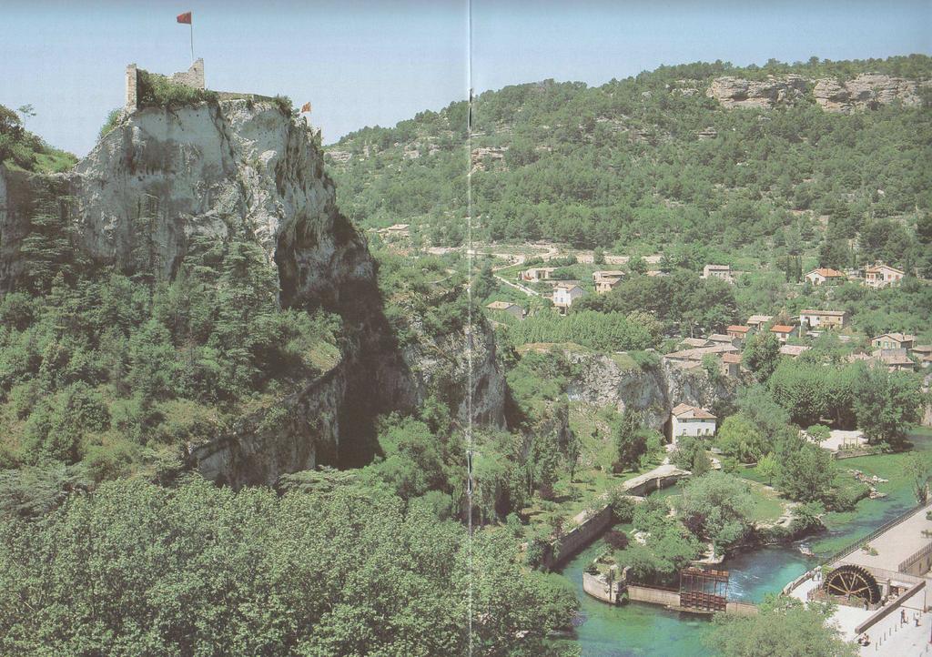
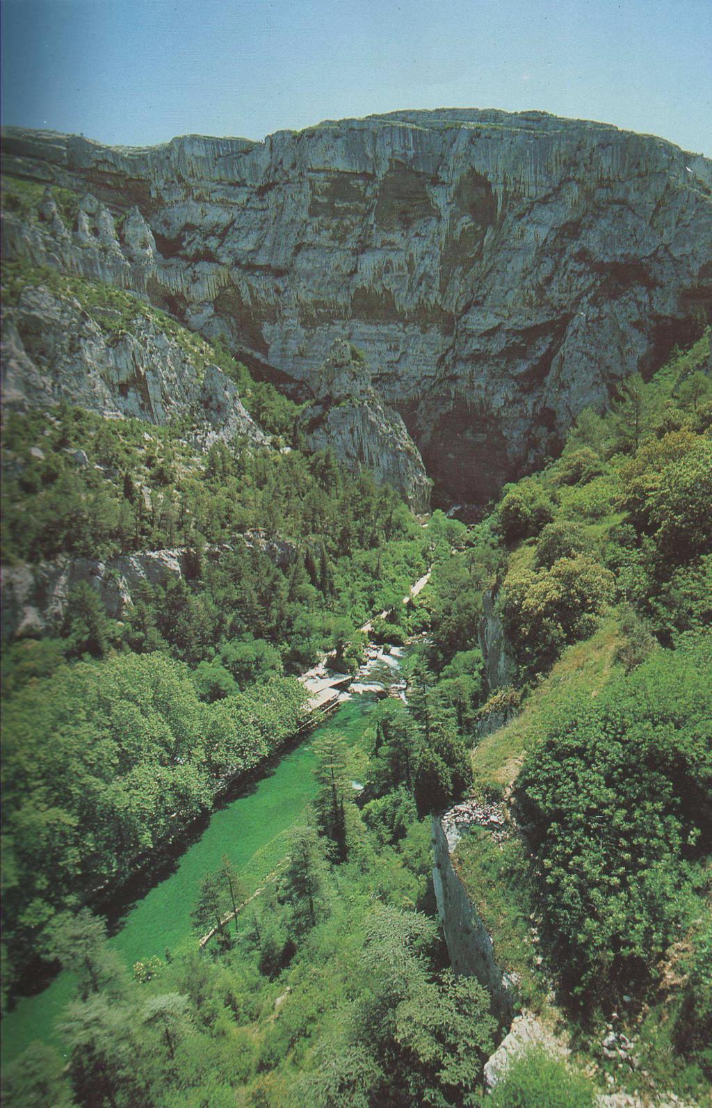
2 The Fontaine de Vaucluse represents one of the most famous and most important karst springs on the Earth. It is located in the south-eastern karst region of France, about 30 km eastward of the town of Avignon. It represents the only flow exit from the 1500 m thick karst aquifer of Lower Cretaceous limestone. The karst system of the Fontaine de Vaucluse is characterised by an approximately 800 m unsaturated zone. Role of this zone for the transformation of rainfall into runoff is important. The Fontaine de Vaucluse karst spring catchment area is estimated to be 1130 km 2 (Cognard-Plancq et al a; 2006.b), but the exact boundaries and area did not defined despite of many investigations. Gilli & Audra (2004) state that the watershed spreads over a 1400 km 2 surface. The average catchment altitude is 870 m a. s. l. The average annual air temperature of the catchment is 9.6 C.
3 In the studies related to the genesis of the karstic system, two hypotheses are evoked: a spring that has always existed in that place, with a vertical water flow aligned on a main fault; a spring using an inherited karstic feature installed with a very different palaeogeographic context at the Messinian period.
4
5
6

7 High water
8 Low water

9 Spring exit
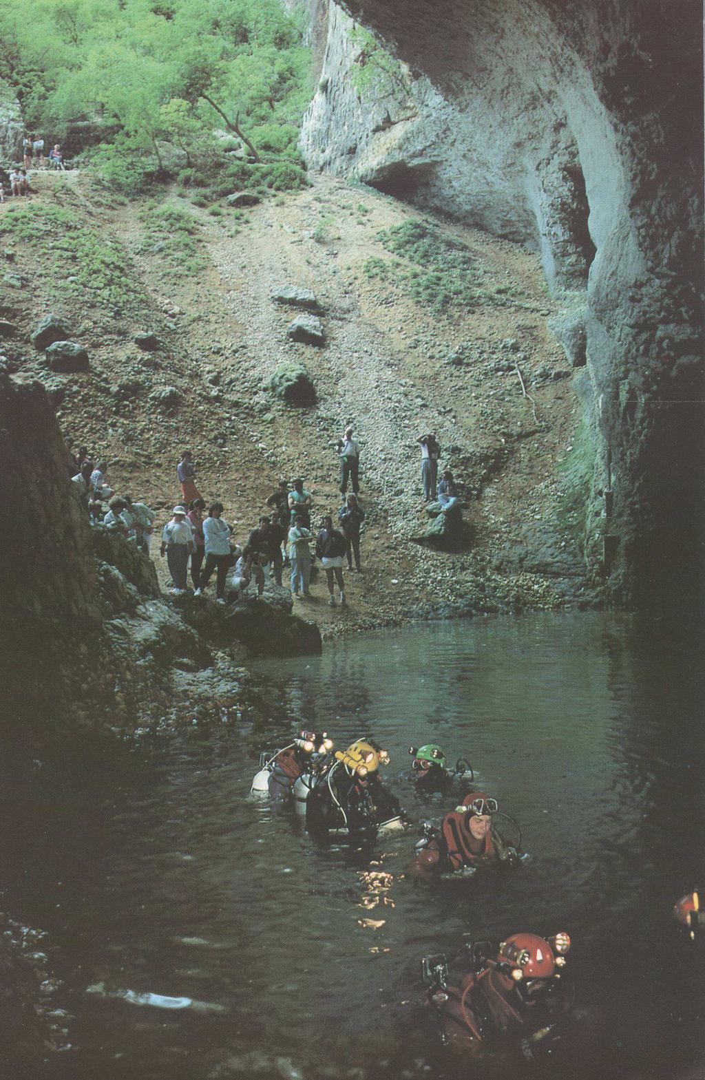
10 Diving expedition
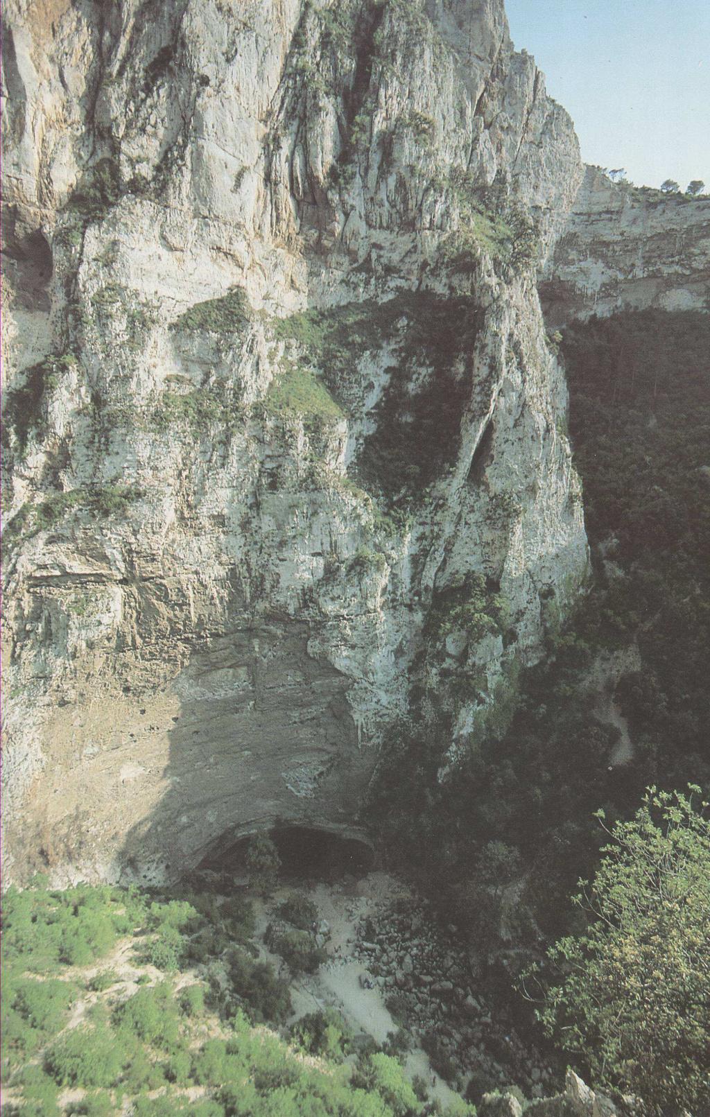
11 The Fontaine de Vaucluse is typical ascending karst spring. Its limestone channel ranges in diameter from 8 to 30 m. The lowest depth reached by diver was -308 m below the gauging station datum of m a. s. l. This depth is still not at the bottom of the ascending karst channel. The maximum water level measured at the gauging station was m above the datum, the minimum was a few centimetres below the datum. The rate of the maximum discharge of the spring has never been precisely measured, but it is estimated that maximum spring discharge varies between 100 and 120 m 3 /s. This surmise identifies a karst spring with limited discharge capacity. The historical minimum discharge is 3.7 m 3 /s.
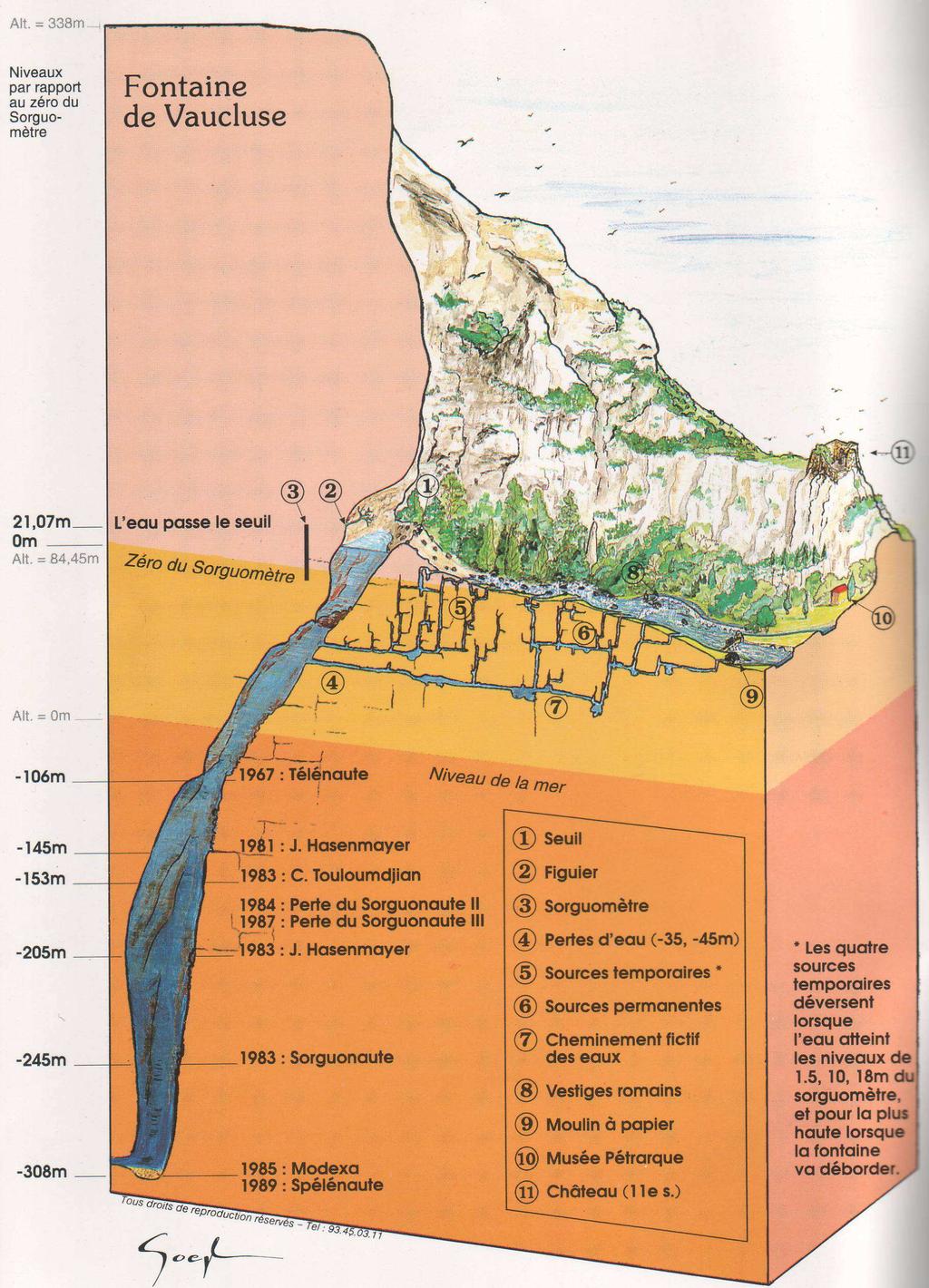
12 SEA LEVEL
13 Cross-section through the Fontaine de Vaucluse main conduit
14 Overflow through karst conduit at altitude m a.s.l. (H = m) period OVERFLOW - N (day) N = 8,7159 Q - 51,6 R = 0, ,00 5,00 10,00 15,00 20,00 25,00 30,00 35,00 MEAN ANNUAL DISCH. - Q (m 3 /s) N average = 110 days; N min = 0 (1967); N max = 281 days (1977)


15 Water level gauging station 0 = m a.s.l.
16 Every karst aquifer has complex hydrodynamic behaviour. The Fontaine de Vaucluse karst system responses to rainfall quite rapid in comparison with the large recharge area. The peak of hydrograph occurred 24 to 72 hours after the rainfall events. The spring water level and discharge recessions are slow, which can be explained by the existence of a large storage capacity of the aquifer. The primary objective of the investigation was to define subperiods with different hydrological behaviour of the Fontaine de Vaucluse karst spring during 127 years period ( ), analysing time series of mean annual spring discharges. It should be the first step in explanation of this extremely important and interesting phenomenon.
17 Stagedischarge relationship
18 The climate in the catchment is Mediterranean. Rainfall distribution over the year as well as over the large spring catchment is irregular. Intensive and significant rainfall events occurred during autumn and spring, while summer and winter are generally dry. Interannual fluctuations of rainfall on the catchment are very high. The average annual catchment rainfall in the period is 1096 mm, while the minimum and maximum observed values were 641 mm (1953) and 1740 mm (1977) respectively.

19 Data series with linear trend line of the annual rainfall on the Fontaine de Vaucluse catchment for the period The increasing trend of the catchment rainfall of mm per year is not statistically significant but should not be neglected in further analyses.

20 Data series with linear trend line of the mean annual spring discharges Q for the period The decreasing trend of the mean annual discharges of m 3 /s per year is not statistically significant. The average annual catchment discharge in the period was 23.3 m 3 /s, while the minimum and maximum observed values were 7.61 m 3 /s (1990) and 53.4 m 3 /s (1915) respectively. It should be stressed that annual catchment rainfall during the same period has an increasing trend.
21 ,000 0,800 0,600 0,400 0,200 0, ,200-0,400 P LAG (year) Q COEF. OF LIN. AUTOCORELATION - r
22 Mean monthly discharges in two sub-periods 40,00 35, Q - (m 3 /s) 30,00 25,00 20,00 15, ,00 5,00 0, TIME (month)
23 Linear regression between the mean annual the Fontaine de Vaucluse discharges Q and the Fontaine de Vaucluse catchment annual rainfall P The linear correlation coefficient is only 0.713, which is relatively low. A special problem is that the regression line cut abscissa line at 222 mm of annual rainfall P, which is relatively low value.
24 ,000 0,800 0,600 0,400 0,200 0, ,200-0,400-0,600-0,800-1,000 LAG (year) COEF. OF LIN. CROSSCORELATION - r
25 Explanation of so unusual rainfall-runoff relationship can be found in fact that accuracy of discharges and rainfalls are not very high, and maybe the value of catchment area of 1130 km 2 is not precisely defined. It should be stressed that determination of exact catchment area in karst is one of the greatest and very often unsolved problems. This may be the case with the catchment of the Fontaine de Vaucluse spring. The weak relationship between runoff and rainfall means that some other factors (probably: air temperature, groundwater level, interannual rainfall distribution, changes of catchment area during the time, preceding soil wetness, anthropological influences, climate change etc) have influence on it.
26 A time series analysis can detect and quantify trends and fluctuations in records. The Rescaled Adjusted Partial Sums (RAPS) method was used for this purpose. A visualisation approach based on the RAPS overcomes small systematic changes in records and variability of the data values themselves. The RAPS visualisation highlights trends, shifts, data clustering, irregular fluctuations, and periodicities in the record. It should be stressed that the RAPS method is not without shortcomings. The values of RAPS are defined by equation: where Y is sample mean; RAPS k = SY is standard deviation; n is number of values in the time series; (k=1, 2,n) is counter limit of the current summation. The plot of the RAPS versus time is the visualisation of the trends and fluctuations of Y k t= 1 Y t S t Y Y
 1878-1910; 2) 1911-1941; 3) 1942-1959; 4) 1960-1964; 5)")
27 Time data series of Rescaled Adjusted Partial Sums (RAPS) for mean annual spring discharges in the period The total data series was divided into next five subsets: 1) ; 2) ; 3) ; 4) ; 5)
28 Time data series of Rescaled Adjusted Partial Sums (RAPS) for annual catchment rainfall P in the period RAPS for P t (year)
29 Five time data sub-series of the Fontaine de Vaucluse karst spring mean annual discharges Q with trend lines for five defined sub-periods 60,00 50,00 1 ( ) 2 ( ) 4 ( ) Q m4 = 34.0 m 3 /s 5 ( ) 40,00 Q m5 = 19.0 m 3 /s Q (m 3 /s) 30,00 20,00 10,00 Q m2 = 29.4 m 3 /s 3 ( ) Q m1 = 22.1 m 3 /s Q m3 = 21.8 m 3 /s 0, t (year)
30 In order to investigate statistically significant differences between the averages of five time sub-series for Q and P the t-test was used. The neighbouring averages of discharges for all five sub-series are statistically significant at the 5 % and even more 1 %. At the same time the neighbouring sub-series averages of the catchment rainfall are not statistically significant.
 and fourth (1960-1964) ones are higher than the linear correlation coefficient for whole")
31 Five linear regressions between mean annual discharges Q and annual catchment rainfall P defined for five different subperiods Linear correlation coefficients for all sub-series, except for third ( ) and fourth ( ) ones are higher than the linear correlation coefficient for whole time series.
32 CONCLUSIONS Variations in the Fontaine de Vaucluse karst spring hydrological regime during relatively short period of 127 years are very strong and cannot be neglected. Anthropogenic impacts are probably the main cause of such behaviour of the mean annual spring discharges time series analysed, but the natural pattern of drought and wet years is also possible. Land-use changes and overexploitation of surface water and groundwater at the spring catchment on hydrological regime of the Fontaine de Vaucluse spring certainly exists. Their exact quantification during analysed period is extremely questionable due to missing of many parameters. Strict division of natural and anthropogenic influences on the hydrological regime is hardly possible. The significant changes of spring discharge characteristics during 127 years long period ( ) can be caused by natural climatic variations, by anthropogenic influences, and possibly by climate changes. It is extremely hard, but at the same time extremely practically and theoretically important, to find correct and scientifically based explanation of this phenomenon.
33 Correct answers on many questions dealing with changes in hydrologicalhydrogeological regime of the Fontaine de Vaucluse karst spring cannot be done using only annual data. Some processes can be explained measuring and analysing climatologic, hydrologic, hydrogeological and geochemical interactions in shorter as well as larger time increments. The problem is that most of parameters required for these analyses were not monitored in the past. More accurate and precise delineation and definition of the Fontaine de Vaucluse spring catchment should be done. It is possible that its catchment area changes as a function of groundwater level. This means that groundwater level measurements in deep piezometers should be organized across the catchment. The second task which should be considered in further analyses is detailed analysis of influence of rainfall distribution during the year on the spring runoff. This can have very strong influence on the relationship between rainfall and runoff, especially in karst areas. It can be stated that main dilemmas about variations of mean annual discharges of the Fontaine de Vaucluse karst spring during 127 years long period have not been solved. They should be explained using number of different procedures and climatic as well as other indicators, and performing further detailed measurements and analyses. The paper presents the need for interdisciplinary analyses incorporating several approaches and techniques. For the sustainable development and the protection of such valuable water resource it is very important to establish prerequisites for the definition of a causes and consequences of its hydrological changes.
34 ACKNOWLEDGEMENT The author thanks to Anne-Laure Cognard-Plancq and Christophe Emblanch from Laboratoire d'hydrogéologie, Faculté des Sciences, Université d'avignon et Pays de Vaucluse Avignon, 33 Rue Louis Pasteur, France, which kindly provide me with data analysed in this paper.

35 THANK YOU FOR YOUR KIND ATTENTION!
Aurore PERINEAU, Christophe EMBLANCH, Charles DANQUIGNY. (UMR EMMAH INRA UAPV)
") Aurore PERINEAU, Christophe EMBLANCH, Charles DANQUIGNY aurore.perineau@etd.univ-avignon.fr (UMR EMMAH INRA UAPV) Location : South-East of France Karst aquifer RESEARCH AREA 2 Fontaine de Vaucluse Catchment
Aurore PERINEAU, Christophe EMBLANCH, Charles DANQUIGNY aurore.perineau@etd.univ-avignon.fr (UMR EMMAH INRA UAPV) Location : South-East of France Karst aquifer RESEARCH AREA 2 Fontaine de Vaucluse Catchment
Error Analysis and Data Quality
 Error Analysis and Data Quality B-1 Error Analysis The overall accuracy of water budget calculations depends on the relative accuracy of the input data. A simplified example is discussed as follows to
CLIMATE VARIABILITY AND GROUNDWATER RECHARGE: CASE STUDY OF WATER BALANCE FOR THE CENTRAL NORTH BULGARIA
 CLIMATE VARIABILITY AND GROUNDWATER RECHARGE: CASE STUDY OF WATER BALANCE FOR THE CENTRAL NORTH BULGARIA Tatiana Orehova, Tanya Vasileva Geological Institute BAS 24, Acad. G. Bonchev Str., 1113, Sofia,
A simple model for low flow forecasting in Mediterranean streams
 European Water 57: 337-343, 2017. 2017 E.W. Publications A simple model for low flow forecasting in Mediterranean streams K. Risva 1, D. Nikolopoulos 2, A. Efstratiadis 2 and I. Nalbantis 1* 1 School of
Comparison of Recharge Estimation Methods Used in Minnesota
 Comparison of Recharge Estimation Methods Used in Minnesota by Geoffrey Delin, Richard Healy, David Lorenz, and John Nimmo Minnesota Ground Water Association Spring Conference Methods for Solving Complex
8.4.2 Steady flow: Hooghoudt equation
 8.4.2 Steady flow: Hooghoudt equation As explained in Section 1.1, steady flow does not,. in reality, occur. At the end of tail recession, however, because of a small amount of seepage, the flow of some
HYDRODYNAMICS OF A COASTAL KARST AQUIFER AFFECTED BY SALTWATER INTRUSION UNDER OCEANIC CLIMATIC INFLUENCE, CO. CLARE, IRELAND
 HYDRODYNAMICS OF A COASTAL KARST AQUIFER AFFECTED BY SALTWATER INTRUSION UNDER OCEANIC CLIMATIC INFLUENCE, CO. CLARE, IRELAND Marie Perriquet 1,2 ;Tiernan Henry 1 ;Rachel Cave 1 ;Véronique Leonardi 2 ;Hervé
Hydrology and Water Management. Dr. Mujahid Khan, UET Peshawar
 Hydrology and Water Management Dr. Mujahid Khan, UET Peshawar Course Outline Hydrologic Cycle and its Processes Water Balance Approach Estimation and Analysis of Precipitation Data Infiltration and Runoff
PARAMETERS OF LOW FLOW AND DATA ON LOW FLOWS IN SELECTED IRISH RIVERS
 PARAMETERS OF LOW FLOW AND DATA ON LOW FLOWS IN SELECTED IRISH RIVERS, Senior Scientific Officer, Environmental Protection Agency SUMMARY Low flow conditions in Ireland are usually expressed in terms of
Introduction. Keywords: Oil Palm, hydrology, HEC-HMS, HEC-RAS. a * b*
 The Effect of Land Changes Towards in Sg. Pandan Perwira Bin Khusairi Rahman 1,a* and Kamarul Azlan bin Mohd Nasir 1,b 1 Faculty of Civil Engineering, Universiti Teknologi Malaysia, Malaysia a * wirakhusairirahman@gmail.com,
Chapter 1 Introduction
 Engineering Hydrology Chapter 1 Introduction 2016-2017 Hydrologic Cycle Hydrologic Cycle Processes Processes Precipitation Atmospheric water Evaporation Infiltration Surface Runoff Land Surface Soil water
IMPACT OF CLIMATE CHANGE IN CONTAMINATION VULNERABILITY OF MESOZOIC KARST AQUIFERS IN BURGOS AREA (SPAIN).
.") IMPACT OF CLIMATE CHANGE IN CONTAMINATION VULNERABILITY OF MESOZOIC KARST AQUIFERS IN BURGOS AREA (SPAIN). By: Dr. Luis Marcos UNIVERSITY OF BURGOS (Spain) Index Aquifers in Spain. High Arlanza Basin.
IMPACT OF CLIMATE CHANGE IN CONTAMINATION VULNERABILITY OF MESOZOIC KARST AQUIFERS IN BURGOS AREA (SPAIN). By: Dr. Luis Marcos UNIVERSITY OF BURGOS (Spain) Index Aquifers in Spain. High Arlanza Basin.
Introduction, HYDROGRAPHS
 HYDROGRAPHS Sequence of lecture Introduction Types of Hydrograph Components of Hydrograph Effective Rainfall Basin Lag or Time Lag Parts of Hydrograph Hydrograph Analysis Factors Affecting Hydrograph Shape
SEES 503 SUSTAINABLE WATER RESOURCES. Floods. Instructor. Assist. Prof. Dr. Bertuğ Akıntuğ
 SEES 503 SUSTAINABLE WATER RESOURCES Floods Instructor Assist. Prof. Dr. Bertuğ Akıntuğ Civil Engineering Program Middle East Technical University Northern Cyprus Campus SEES 503 Sustainable Water Resources
Groundwater Level and Movement
 Groundwater Level and Movement Infiltration and Recharge Infiltration Entry of rain water into the ground. Recharge Addition of infiltrated water to the aquifer. Two types of Recharge- 1. Natural 2. Artificial
1 THE USGS MODULAR MODELING SYSTEM MODEL OF THE UPPER COSUMNES RIVER
 1 THE USGS MODULAR MODELING SYSTEM MODEL OF THE UPPER COSUMNES RIVER 1.1 Introduction The Hydrologic Model of the Upper Cosumnes River Basin (HMCRB) under the USGS Modular Modeling System (MMS) uses a
Stream hydrographs. Stream hydrographs. Baseflow. Graphs of river stage or discharge at a single location as a function of time
 Stream hydrographs Graphs of river stage or discharge at a single location as a function of time Hydrologic og budget Discharge: units? How is it measured? Show fluctuating water levels in response to
ASSESSMENT REPORT ENVIRONMENTAL SCIENCE B.S.
 Department of Earth and Environmental Sciences California State University, East Bay ASSESSMENT REPORT 2016 17 ENVIRONMENTAL SCIENCE B.S. 20 September 2017 Assessment Report 2016 17 Environmental Science
Level 6 Graduate Diploma in Engineering Hydraulics and hydrology
 910-103 Level 6 Graduate Diploma in Engineering Hydraulics and hydrology Sample Paper You should have the following for this examination one answer book ordinary graph paper pen, pencil, ruler Work sheet
Sixth Semester B. E. (R)/ First Semester B. E. (PTDP) Civil Engineering Examination
/ First Semester B. E. (PTDP) Civil Engineering Examination") CAB/2KTF/EET 1221/1413 Sixth Semester B. E. (R)/ First Semester B. E. (PTDP) Civil Engineering Examination Course Code : CV 312 / CV 507 Course Name : Engineering Hydrology Time : 3 Hours ] [ Max. Marks
CAB/2KTF/EET 1221/1413 Sixth Semester B. E. (R)/ First Semester B. E. (PTDP) Civil Engineering Examination Course Code : CV 312 / CV 507 Course Name : Engineering Hydrology Time : 3 Hours ] [ Max. Marks
RESERVOIR HYDROLOGIC ROUTING FOR WATER BALANCE OF AL-BURULLUS WETLAND, EGYPT
 RESERVOIR HYDROLOGIC ROUTING FOR WATER BALANCE OF AL-BURULLUS WETLAND, EGYPT Ibrahim Abdelmagid El-Shinnawy Associate Prof., Environment and Climate Research Institute (ECRI) National Water Research Center
Assessing SWMM 5 Hydrologic Parameter Benefits for Model Calibration
 Assessing SWMM 5 Hydrologic Parameter Benefits for Model Calibration Justin Siegrist, 1 Daniel Anderson, 2 Joseph Koran, 2 Mark Pribak, 3 Uzair M. (Sam) Shamsi 4 and Dave White 1 1 Wade Trim, Inc., Cincinnati,
Infiltration processes in karst using an event-based conceptual model of flow and transport of dissolved organic carbon
 Infiltration processes in karst using an event-based conceptual model of flow and transport of dissolved organic carbon Jean-Baptiste Charlier, Jacques Mudry, Catherine Bertrand To cite this version: Jean-Baptiste
A peaks over threshold approach for hydrological drought severity assessment.
 15 th International Conference on Environmental Science and Technology Rhodes, Greece, 31 August to 2 September 2017 A peaks over threshold approach for hydrological drought severity assessment. Sarailidis
THE QUANTIFICATION OF THE THRESHOLD LEVEL METHOD ON LOW FLOWS STUDIES
 Proceedings of the 14 th International Conference on Environmental Science and Technology Rhodes, Greece, 3-5 September 2015 THE QUANTIFICATION OF THE THRESHOLD LEVEL METHOD ON LOW FLOWS STUDIES SARAILIDIS
Protection of Jeita Spring
 Council for Development and Reconstruction (CDR) Ministry of Energy and Water (MoEW) Water Establishment Beirut and Mount Lebanon (WEBML) Federal Institute for Geosciences and Natural Resources (BGR),
Integrating soakaway infiltration devices in distributed urban drainage models from allotment to neighbourhood scale
 Integrating soakaway infiltration devices in distributed urban drainage models from allotment to neighbourhood scale M. Bergman*, P. Binning*, G. Kuczera **, P. S. Mikkelsen* and O. Mark*** * Department
EUROPEAN APPROACH IN ASSESSING GROUNDWATER VULNERABILITY OF THE MURÁNSKA PLANINA PLATEAU, SLOVAKIA
 EUROPEAN APPROACH IN ASSESSING GROUNDWATER VULNERABILITY OF THE MURÁNSKA PLANINA PLATEAU, SLOVAKIA P. MALÍK and J. ŠVASTA Geological Survey of Slovak Republic, Mlynska dolina 1, 817 04 Bratislava, Slovak
Estimating parameters of groundwater recharge model in frequency domain
 322 Calibration and Reliability in Groundwater Modelling: Credibility of Modelling (Proceedings of ModelCARE 2007 Conference, held in Denmar, September 2007). IAHS Publ. 320, 2008. Estimating parameters
Determination of Recharge area using Environmental Isotopes in Karstified Aquifers in Balisan area, Kurdistan Region, Iraq.
 Omed M. Mustafa M.Sc. Environmental Geology Assistant Lecturer Department of Geology College of Science University of Sulaimani Mobile: 009647701540252 Email: omedgeology@gmail.com omed.mustafa@univsul.net
Task 4.2 Technical Memorandum on Pumping Impacts on Squaw Creek
 Task 4.2 Technical Memorandum on Pumping Impacts on Squaw Creek Aquifer Test 1 Aquifer Test 2 Prepared for: Squaw Valley Public Service District April 2013 Prepared by: This page left intentionally blank
Report on Effects of Groundwater Withdrawal from the Doghouse Meadow, Yosemite National Park
 Report on Effects of Groundwater Withdrawal from the Doghouse Meadow, Yosemite National Park William E. Sanford Department of Geosciences Colorado State University 03 March 2006 1 Purpose The purpose of
Stream Hydrology. Watershed 8/29/13. Area that contributes water to a point on a stream Scale is user-defined Other names: Catchment Drainage basin
 Stream Hydrology Watershed Area that contributes water to a point on a stream Scale is user-defined Other names: Catchment Drainage basin http://warnercnr.colostate.edu/geo/front_range/poudre.php# 1 Basics
4.4 MODEL CODE DESCRIPTION 4.5 WATER SOURCES AND SINKS 4.6 MODEL DOMAIN AND BOUNDARIES. SLR South Africa
 Page 4-18 The developed model should therefore be seen as an initial site model which should be refined and recalibrated once more groundwater monitoring and other data become available. 4.4 MODEL CODE
6. Hydrogeological zones and groundwater resources balance baseflow map of the Czech Republic. Jiri Sima
 6. Hydrogeological zones and groundwater resources balance baseflow map of the Czech Republic Jiri Sima General content Regional hydrogeological units Groundwater resources assessment Water balancing background
Oversized quarry sumps can be used to store run-off during
 Oversized quarry sumps can be used to store run-off during large events Paved quarry yard with channels routing run-off to attenuation 3 The Hydrogeology of Quarry Dewatering Extraction below the water
Effect of Conjunctive Use of Water for Paddy Field Irrigation on Groundwater Budget in an Alluvial Fan ABSTRACT
 1 Effect of Conjunctive Use of Water for Paddy Field Irrigation on Groundwater Budget in an Alluvial Fan Ali M. Elhassan (1), A. Goto (2), M. Mizutani (2) (1) New Mexico Interstate Stream Commission, P.
Spatial Variation of Unit Hydrograph Parameters for Rainfall Derived Infiltration/Inflow and the Relationship with Physical Factors
 4 Spatial Variation of Unit Hydrograph Parameters for Rainfall Derived Infiltration/Inflow and the Relationship with Physical Factors Li Zhang, Fang Cheng, Gregory Barden, Hunter Kelly, Timothy Fallara
Does a fifteen-hour shift make much difference? Influence of time lag between rainfall and discharge data on model calibration
 22nd International Congress on Modelling and Simulation, Hobart, Tasmania, Australia, 3 to 8 December 2017 mssanz.org.au/modsim2017 Does a fifteen-hour shift make much difference? Influence of time lag
Modeling the Impacts of Climate Change on Groundwater Recharge in the Gharehsoo Watershed, Iran, from an Ensemble of Global Climate Model Projections
 INTERNATIONAL SWAT CONFERENCE 2015 Modeling the Impacts of Climate Change on Groundwater Recharge in the Gharehsoo Watershed, Iran, from an Ensemble of Global Climate Model Projections Majid Taie Semiromi
Comparing Agricultural and Urban Nutrient Loads to Coastal Systems
 Comparing Agricultural and Urban Nutrient Loads to Coastal Systems João Pedro NUNES, João Gomes FERREIRA University of Aveiro, Portugal NOVA University of Lisbon, Portugal Longline Environment, UK Nutrient
Urbanization effects on the hydrology of the Atlanta area, Georgia (USA)
") 14/06/01 Impact of Human Activity on Groundwater Dynamics (Proceedings of a symposium held during the Sixth IAHS Scientific Assembly at Maastricht, The Netherlands, July 2001). IAHS Publ. no. 269, 2001.
14/06/01 Impact of Human Activity on Groundwater Dynamics (Proceedings of a symposium held during the Sixth IAHS Scientific Assembly at Maastricht, The Netherlands, July 2001). IAHS Publ. no. 269, 2001.
Aquifer Science Staff, January 2007
 Guidelines for Hydrogeologic Reports and Aquifer Tests Conducted Within the Jurisdictional Boundaries of the Barton Springs / Edwards Aquifer Conservation District I. Introduction Aquifer Science Staff,
University of Arizona Department of Hydrology and Water Resources Dr. Marek Zreda
 University of Arizona Department of Hydrology and Water Resources Dr. Marek Zreda HWR431/531 - Hydrogeology Final exam - 12 May 1997 Open books and notes The test contains 8 problems on 7 pages. Read the
SWEM QUESTIONS FOR MODEL WORKSHOP
 SWEM QUESTIONS FOR MODEL WORKSHOP A. Management Overview What is the purpose (i.e., heuristic or predictive?) of the model as a management tool? In principle, SWEM is meant to be a predictive tool, although
APPLICATION OF THE SWAT (SOIL AND WATER ASSESSMENT TOOL) MODEL IN THE RONNEA CATCHMENT OF SWEDEN
 MODEL IN THE RONNEA CATCHMENT OF SWEDEN") Global NEST Journal, Vol 7, No 3, pp 5-57, 5 Copyright 5 Global NEST Printed in Greece. All rights reserved APPLICATION OF THE SWAT (SOIL AND WATER ASSESSMENT TOOL) MODEL IN THE RONNEA CATCHMENT OF SWEDEN
Global NEST Journal, Vol 7, No 3, pp 5-57, 5 Copyright 5 Global NEST Printed in Greece. All rights reserved APPLICATION OF THE SWAT (SOIL AND WATER ASSESSMENT TOOL) MODEL IN THE RONNEA CATCHMENT OF SWEDEN
Report on an intercomparison study of modelled, Europe-wide forest fire risk for present day conditions
 Contract number GOCE-CT-2003-505539 http://www.ensembles-eu.org RT6/WP6.2 - Linking impact models to probabilistic scenarios of climate Deliverable D6.9 Report on an intercomparison study of modelled,
Manifesto from the Workshop Climate Change Impacts on Groundwater
 Manifesto from the Workshop Climate Change Impacts on Groundwater EU Working Group C workshop October 12th, Warsaw A workshop on Climate Change Impacts on Groundwater was held in Warsaw under the umbrella
Scale Effects in Large Scale Watershed Modeling
 Scale Effects in Large Scale Watershed Modeling Mustafa M. Aral and Orhan Gunduz Multimedia Environmental Simulations Laboratory School of Civil and Environmental Engineering Georgia Institute of Technology
UNIT HYDROGRAPH AND EFFECTIVE RAINFALL S INFLUENCE OVER THE STORM RUNOFF HYDROGRAPH
 UNIT HYDROGRAPH AND EFFECTIVE RAINFALL S INFLUENCE OVER THE STORM RUNOFF HYDROGRAPH INTRODUCTION Water is a common chemical substance essential for the existence of life and exhibits many notable and unique
Evaluation of Swat for Modelling the Water Balance and Water Yield in Yerrakalva River Basin, A.P. National Institute of Hydrology, Roorkee
 Evaluation of Swat for Modelling the Water Balance and Water Yield in Yerrakalva River Basin, A.P. By Dr. J.V. Tyagi Dr. Y.R.S. Rao National Institute of Hydrology, Roorkee INTRODUCTION Knowledge of water
Master of Science Practical Exam. Climate and Hydrology of Big Spring Creek, Cumberland County, Pennsylvania
 Master of Science Practical Exam Climate and Hydrology of Big Spring Creek, Cumberland County, Pennsylvania Laurie Young Revised January 27,212- February 3,212 For: Dr. Woltemade Dr. Feeney Table of Contents
HYDROLOGICAL ANALYSIS OF FLOW VARIATIONS ON SHPP SITE
 13 th International Symposium on Water Management and Hydraulic Engineering, September 9-12, 2013 Bratislava, Slovakia HYDROLOGICAL ANALYSIS OF FLOW VARIATIONS ON SHPP SITE Gordon Gilja 1, Eva Ocvirk 2
Generalization of parameters in the storage discharge relation for a low flow based on the hydrological analysis of sensitivity
 Proc. IAHS, 371, 69 73, 2015 doi:10.5194/piahs-371-69-2015 Author(s) 2015. CC Attribution 3.0 License. Generalization of parameters in the storage discharge relation for a low flow based on the hydrological
Towards quantifying shallow groundwater-climate relationships in central and northern Victoria
 Towards quantifying shallow groundwater-climate relationships in central and northern Victoria Gavin M. #, Sasha Jelecic, Felicity Ginnivan # Lecturer, Institute for Sustainable Water Resources / Dept.
JOURNAL OF APPLIED SCIENCES RESEARCH
 Copyright 2015, American-Eurasian Network for Scientific Information publisher JOURNAL OF APPLIED SCIENCES RESEARCH ISSN: 1819-544X EISSN: 1816-157X JOURNAL home page: http://www.aensiweb.com/jasr Published
San Luis Obispo Creek Watershed Hydrologic Model Inputs
 Jeff Werst San Luis Obispo County Department of Public Works 1050 Monterey Street San Luis Obispo CA 93408 December 14, 2007 Subject: San Luis Obispo Creek Watershed Hydrology and Hydraulic Model Dear
Impact Study of a check dam on Ground Water Recharge
 Impact Study of a check dam on Ground Water Recharge 1 P.Arun Raja, C. Dinesh, B.Jagadeesan 1,, UG Student, Department of Civil Engineering, Mamallan Institute of Technology, Kanchipuram, INDIA Abstract:
Introduction to Hydrology, Part 2. Notes, Handouts
 Introduction to Hydrology, Part 2 Notes, Handouts Precipitation Much of hydrology deals with precipitation How much? How frequently/infrequently? What form? How quickly? Seasonal variation? Drought frequency?
Module 7 GROUNDWATER AND CLIMATE CHANGE
 Module 7 GROUNDWATER AND CLIMATE CHANGE Learning Objectives To become familiar with the basic concepts of the impacts of climate change on groundwater To explore the link between climate change impacts
Cumulative Precipitation
 Problem 1: Hyetograph Construction (4 pts) Use the rainfall information below to construct both the cumulative (inch) and incremental (in/hr) hyetographs. Note: the incremental hyetograph must be formatted
CHAPTER 4 DISCUSSION. Total Flow. For the study watershed, the water budget equation is defined as inflow equals
 CHAPTER 4 DISCUSSION Total Flow For the study watershed, the water budget equation is defined as inflow equals outflow minus any losses. Inflow consists of precipitation. Outflow consists of stream flow
A WEAP Model of the Kinneret Basin
 A WEAP Model of the Kinneret Basin Illy Sivan 1, Yigal Salingar 1 and Alon Rimmer 2 This is an English translation of the article that originally appeared in Sivan, I., Y. Salingar, and A. Rimmer, A WEAP
IAH Conference 2012 Niagara Falls German-Lebanese Technical Cooperation Project
 Council for Development and Reconstruction (CDR) Ministry of Energy and Water (MoEW) Water Establishment t Beirut and Mount Lebanon (WEBML) Federal Institute for Geosciences and Natural Resources (BGR),
Watershed Characteristics: A Case Study of Wadi Es Sir Catchment Area / Jordan
 ISSN: 2319-7706 Volume 4 Number 9 (2015) pp. 98-106 http://www.ijcmas.com Case Study Watershed Characteristics: A Case Study of Wadi Es Sir Catchment Area / Jordan Amany R. Ta any* Ministry of Water and
RAINFALL - RUNOFF MODELING IN AN EXPERIMENTAL WATERSHED IN GREECE
 Proceedings of the 14 th International Conference on Environmental Science and Technology Rhodes, Greece, 3-5 September 2015 RAINFALL - RUNOFF MODELING IN AN EXPERIMENTAL WATERSHED IN GREECE KOTSIFAKIS
Relationships between low-flow characteristics of South African streams
 Relationships between low-flow characteristics of South African streams VY Smakhtin * and M Toulouse Institute for Water Research, Rhodes University, PO Box 94, Grahamstown, 64, South Africa Ecole Nationale
NEURAL NETWORK SIMULATION OF KARSTIC SPRING DISCHARGE
 NEURAL NETWORK SIMULATION OF KARSTIC SPRING DISCHARGE 1 I. Skitzi, 1 E. Paleologos and 2 K. Katsifarakis 1 Technical University of Crete 2 Aristotle University of Thessaloniki ABSTRACT A multi-layer perceptron
Groundwater drought in different geological conditions
 IOP Conference Series: Earth and Environmental Science Groundwater drought in different geological conditions To cite this article: A Machlica and M Stojkovova 2008 IOP Conf. Ser.: Earth Environ. Sci.
Calibration of Hydrologic Design Inputs for a Small Urban Watershed
 Research Project Proposal for Johnson County Stormwater Management Program and City of Overland Park, Kansas Calibration of Hydrologic Design Inputs for a Small Urban Watershed Bruce M. McEnroe & C. Bryan
RAINFALL RUN-OFF AND BASEFLOW ESTIMATION
 CHAPTER 2 RAINFALL RUN-OFF AND BASEFLOW ESTIMATION 2.1 Introduction The west coast of India receives abundant rainfall from the southwest monsoon. The Western Ghats escarpment (Sahyadri mountain range)
Impact of snow melt on the hydrologic and water resources systems, Lebanon
 Snow cover dynamics and snow hydrology of the Lebanese Mountain Chains Using an integrated remote sensing and hydrologic modeling approach Impact of snow melt on the hydrologic and water resources systems,
Managed Aquifer Recharge (MAR) Practical Techniques for the Caribbean
 Practical Techniques for the Caribbean") Managed Aquifer Recharge (MAR) Practical Techniques for the Caribbean Scope of Presentation What is MAR? Antigua and Barbuda water resources issues Why promote MAR? MAR: Techniques MAR: Design criteria
Managed Aquifer Recharge (MAR) Practical Techniques for the Caribbean Scope of Presentation What is MAR? Antigua and Barbuda water resources issues Why promote MAR? MAR: Techniques MAR: Design criteria
ANALYSIS OF RAINFALLINFILTRATION
 ANALYSIS OF RAINFALLINFILTRATION RECHARGE TO GROUNDWATER Jinquan Wu and Renduo Zhang Proceedings 1994 WWRC-94-09 In Proceedings of Fourteenth Annual American Geophysical Union: Hydrology Days Submitted
HyMeX (*) WG2: Hydrological Continental Cycle. I. Braud (1), A. Chanzy (2) *Hydrological cycle in the Mediterranean experiment
 WG2: Hydrological Continental Cycle. I. Braud (1), A. Chanzy (2) *Hydrological cycle in the Mediterranean experiment") HyMeX (*) http://www.hymex.org/ WG2: Hydrological Continental Cycle I. Braud (1), A. Chanzy (2) (1) CEMAGREF, UR HHLY, Lyon, France (2) UME EMMAH, INRA, Avignon, France *Hydrological cycle in the Mediterranean
HyMeX (*) http://www.hymex.org/ WG2: Hydrological Continental Cycle I. Braud (1), A. Chanzy (2) (1) CEMAGREF, UR HHLY, Lyon, France (2) UME EMMAH, INRA, Avignon, France *Hydrological cycle in the Mediterranean
Groundwater Systems and Water Quality Programme Internal Report IR/01/59
 Modelling the impact of climate change on groundwater in the UK Stage 2 Using an unsaturated zone transfer function to model groundwater level fluctuations Groundwater Systems and Water Quality Programme
Contents. Introduction Flash floods events Eastern desert Risk map. Mitigation of study. Literature Review. Methodology. Results.
 Flash Floods Risk Assessment in The Eastern Desert By Eng. Mona M. Mohamed Faculty of Engineering, Ain Shams University Cairo, Egypt eng.mona_200785@yahoo.com Contents. The main goal...... 1 2 Flash floods
Closure Water Balance Model to Support Closure Designs for a Mine in Laos
 Page 1 Closure Water Balance Model to Support Closure Designs for a Mine in Laos BR Luinstra SRK Consulting (Australasia) JT Chapman SRK Consulting (Australasia) A Hendry SRK Consulting (Australasia) A
Assessing Climate Change Impact on Urban Drainage Systems
 Assessing Climate Change Impact on Urban Drainage Systems by Asst/Prof Qin Xiaosheng School of Civil & Environmental Engineering, Nanyang Technological University, Blk N1-01c-82, 50 Nanyang Ave., Singapore
Establishing the influence of climate, water extraction and tectonics on the water level of the Prespa Lakes (N Greece)
") Establishing the influence of climate, water extraction and tectonics on the water level of the Prespa Lakes (N Greece) Tim van der Schriek & Christos Giannakopoulos National Observatory of Athens Institute
Establishing the influence of climate, water extraction and tectonics on the water level of the Prespa Lakes (N Greece) Tim van der Schriek & Christos Giannakopoulos National Observatory of Athens Institute
Modeling catchment scale infiltration
 Modeling catchment scale infiltration Serena Ceola, DICAM, University of Bologna Advanced Hydrology & Water Resources Management INTRODUCTION OBJECTIVE: Understanding the processes and the methods for
A study of surface water and groundwater using isotopes in Huaishahe basin in Beijing, China
 106 Sustainability of Groundwater Resources and its Indicators (Proceedings of symposium S3 held during the Seventh IAHS Scientific Assembly at Foz do Iguaçu, Brazil, April 2005). IAHS Publ. 302, 2006.
ENGINEERING HYDROLOGY
 ENGINEERING HYDROLOGY Prof. Rajesh Bhagat Asst. Professor Civil Engineering Department Yeshwantrao Chavan College Of Engineering Nagpur B. E. (Civil Engg.) M. Tech. (Enviro. Engg.) GCOE, Amravati VNIT,
Rainfall-recharge correlation; a method for evaluating potential groundwater
 Improvements of Methods of Long Term Prediction of Variations in Groundwater Resources and Regimes Due to Human Activity (Proceedings of the Exeter Symposium, July 1982). IAHS Publ. no. 136. Rainfall-recharge
Groundwater Resources of the Kabul Basin, Afghanistan
 Groundwater Resources of the Kabul Basin, Afghanistan Dr. Thomas Himmelsbach Joint Afghan-BGR BGR-Project commissioned by Federal Foreign Office of Germany Federal Institute for Geosciences and Natural
CHAPTER FIVE Runoff. Engineering Hydrology (ECIV 4323) Instructors: Dr. Yunes Mogheir Dr. Ramadan Al Khatib. Overland flow interflow
 Instructors: Dr. Yunes Mogheir Dr. Ramadan Al Khatib. Overland flow interflow") Engineering Hydrology (ECIV 4323) CHAPTER FIVE Runoff Instructors: Dr. Yunes Mogheir Dr. Ramadan Al Khatib Overland flow interflow Base flow Saturated overland flow ١ ٢ 5.1 Introduction To Runoff Runoff
Engineering Hydrology (ECIV 4323) CHAPTER FIVE Runoff Instructors: Dr. Yunes Mogheir Dr. Ramadan Al Khatib Overland flow interflow Base flow Saturated overland flow ١ ٢ 5.1 Introduction To Runoff Runoff
Capão Xavier Mine Water Drainage Management (Minas Gerais, Brazil)
") Capão Xavier Mine Water Drainage Management (Minas Gerais, Brazil) Rafael Fernández Rubio 1,2, Fabiana Vasconcelos Caldas 3, David Lorca Fernández 2, César Grandchamp 3, Mauro Lobo de Razende 3 1 Madrid
Capão Xavier Mine Water Drainage Management (Minas Gerais, Brazil) Rafael Fernández Rubio 1,2, Fabiana Vasconcelos Caldas 3, David Lorca Fernández 2, César Grandchamp 3, Mauro Lobo de Razende 3 1 Madrid
Climate Change and the Eastern Mediterranean Precipitation Regime
 Climate Change and the Eastern Mediterranean Precipitation Regime Manfred A. Lange Energy, Environment and Water Research Center, The Cyprus Institute EWACC2010 Energy, Water & Climate Change in the Mediterranean
Linking hydrology to erosion modelling in a river basin decision support and management system
 Integrated Water Resources Management (Proceedings of a symposium held at Davis. California. April 2000). I APIS Publ. no. 272. 2001. 243 Linking hydrology to erosion modelling in a river basin decision
Reservoirs performances under climate variability: a case study
 526 Evolving Water Resources Systems: Understanding, Predicting and Managing Water Society Interactions Proceedings of ICWRS24, Bologna, Italy, June 24 (IAHS Publ. 364, 24). Reservoirs performances under
A Method to Estimate Buna River Discharge, Albania
 Hydrology Days 2009 A Method to Estimate Buna River Discharge, Albania Niko PANO 1, Bardhyl AVDYLI 2 Tirana University Faculty of History Philology, Geography Department Tirana, Albania. Abstract Buna
Continuous Simulation Modeling of Stormwater Ponds, Lakes, & Wetlands: A BUILT-IN APPLICATION OF PONDS 3.2
 Continuous Simulation Modeling of Stormwater Ponds, Lakes, & Wetlands: A BUILT-IN APPLICATION OF PONDS 3.2 PRESENTED AT THE SFWMD WORKSHOP PRE-DEVELOPMENT VERSUS POST DEVELOPMENT RUNOFF VOLUME ANALYSIS
Hydrology and Water Resources Engineering
 Hydrology and Water Resources Engineering SUB GSttingen 214 868 613 K.C. Patra 't'v Mai Narosa Publishing House New Delhi Chennai Mumbai Calcutta CONTENTS Preface vii 1. Introduction 1 1.1 General 1 1.2
D.G.S.W. Pitakumbura Manager (Groundwater Studies) Groundwater Section NWS&DB. Groundwater recharge or deep drainage or
 Groundwater Section NWS&DB. Groundwater recharge or deep drainage or") Groundwater Recharge and Extraction Techniques D.G.S.W. Pitakumbura Manager (Groundwater Studies) Groundwater Section NWS&DB What is Groundwater Recharge Groundwater recharge or deep drainage or deep percolation
Groundwater Recharge and Extraction Techniques D.G.S.W. Pitakumbura Manager (Groundwater Studies) Groundwater Section NWS&DB What is Groundwater Recharge Groundwater recharge or deep drainage or deep percolation
Lecture 20: Groundwater Introduction
 Lecture 20: Groundwater Introduction Key Questions for Groundwater 1. What is an aquifer? 2. What is an unconfined aquifer? 3. What is groundwater recharge? 4. What is porosity? What determines the magnitude
Prediction for Natural Recharging In Langat Basin and Ukm Campus as Case Study
 Prediction for Natural Recharging In Langat Basin and Ukm Campus as Case Study 1 Mohaad Fawzi Al Ajlouni, 2 Rakmi Abd Rahman, 3 Abdul Ghani Rafek, 4 Mazlin Mokhtar, 5 Noor Ezlin Ahmad Basri 1, 5 Department
Contents of this file. Figures S1 to S7 Table S1. Introduction
 1 2 3 4 5 Contents of this file Figures S1 to S7 Table S1 6 Introduction 7 8 9 10 11 This Supporting Information provides illustration of the piezometer locations at Khulna and Laksmipur (Figures S4 and
BAEN 673 / February 18, 2016 Hydrologic Processes
 BAEN 673 / February 18, 2016 Hydrologic Processes Assignment: HW#7 Next class lecture in AEPM 104 Today s topics SWAT exercise #2 The SWAT model review paper Hydrologic processes The Hydrologic Processes
IJSER. within the watershed during a specific period. It is constructed
 International Journal of Scientific & Engineering Research, Volume 5, Issue 7, July-014 ISSN 9-5518 306 within the watershed during a specific period. It is constructed I. INTRODUCTION In many instances,
Appendix L Preliminary trend analysis methodology report
 Appendix L Preliminary trend analysis methodology report Methodology for groundwater level trend analysis Rev 0 April 2012 Uncontrolled when printed GROUNDWATER PROJECT Table of Contents 1.0 GROUNDWATER