MODELING SEDIMENT AND PHOSPHORUS YIELDS USING THE HSPF MODEL IN THE DEEP HOLLOW WATERSHED, MISSISSIPPI
|
|
|
- James Allison
- 6 years ago
- Views:
Transcription


1 MODELING SEDIMENT AND PHOSPHORUS YIELDS USING THE HSPF MODEL IN THE DEEP HOLLOW WATERSHED, MISSISSIPPI Jairo Diaz-Ramirez, James Martin, William McAnally, and Richard A. Rebich
2 Outline Background Objectives Study Area HSPF Methods Results Conclusions


3 Background The impact of excess nutrient loads on eutrophication of waterbodies, including the increasingly frequent occurrences of harmful algal blooms and hypoxia, is well known and well documented. The Mississippi River/Gulf of Mexico Hypoxia is also a major environmental issue, and key components of the 2008 Gulf Hypoxia Action Plan are the development and implementation of state nutrient reduction strategies (BMPs, LID) reduce existing scientific uncertainties (Modeling, Monitoring, and Research) regarding source, fate, and transport of nitrogen and phosphorus in the surface waters of the Mississippi/Atchafalaya River Basin to continually improve the accuracy of management tools and efficacy of management strategies for nutrient reductions.


4 Background Effective implementation of nutrient load reductions requires that analytical tools be available to accurately estimate loads from watersheds and waterbodies as a function of hydrologic conditions. Hydrologic models have widely been used to accurately estimate outflows from watersheds, and to a lesser degree sediment and nutrient loads. Factors impacting runoff of nutrients are not well understood and as a consequence predictions of nutrient loads are highly uncertain. The processes associated to sediment and phosphorus transport from agricultural fields are complex due to crop management including tillage, fertilization, and harvest. Evaluation of two hybrid metric-conceptual models for simulating phosphorus transfer from agricultural land in the river enborne, a lowland UK catchment. Journal of Hydrology Volume 304, Issues 1 4, 10 March 2005, Pages Mississippi River/Gulf of Mexico Watershed Nutrient Task Force, 2004, A Science Strategy to Support Management Decisions Related to Hypoxia in the Northern Gulf of Mexico and Excess Nutrients in the Mississippi River Basin: prepared by the Monitoring, Modeling, and Research Workgroup of the Mississippi River/Gulf of Mexico Watershed Nutrient Task Force, U.S. Geological Survey Circular 1270, 58 p.
5 Objectives This research evaluated the ability of the Hydrological Simulation Program FORTRAN (HSPF) to simulate storm, seasonal, and long-term runoff, sediment, and phosphorus transport at the farm scale in the Deep Hollow drainage area, Mississippi. The main goal was to demonstrate the usefulness of HSPF as a computer tool for future environmental management and planning in the Mississippi Delta region.
 11.")
")

 Dubbs loam (13%)")


 Hydrologic Soil")

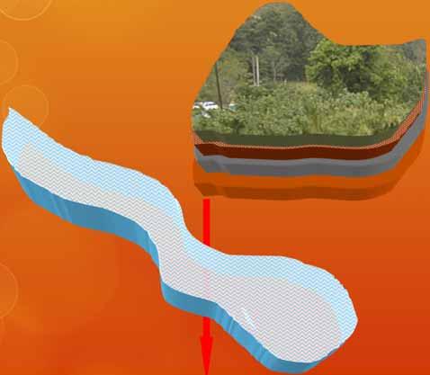
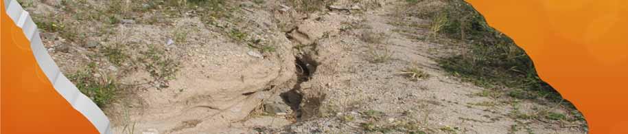
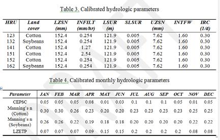
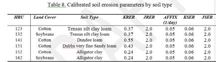
6 Study Area Study Site Deep Hollow Drainage Area (ha) 11.3 Slope (%) 0.3 Land Cover Cotton (76%) Soybeans (24%) Winter wheat Major Soil Type Dundee loam (19%) Tensas silty clay loam (49%) Dubbs loam (13%) Alligator clay (19%) Management Practice Reduced tillage and winter cover crop. 9.5 Kg P/ha on 10/6/1998 Field Data Collection USGS ( ) Hydrologic Soil Group 13% B, 19% C and 68% D Runoff Potential High Deep Hollow drainage area is located in Leflore County, MS.


7 HSPF HSPF: Hydrological Simulation Program - FORTRAN Modular program with capacity of simulation hydrologic cycle, erosion, sediment transport, nutrients, pesticides, and in-stream water quality Used successfully since 80 s in USA, Canada, Europe, Australia, and Africa. Supported by EPA through the BASINS decision support system dels/basins/index.cfm


8 HSPF: Hydrologic Components Impervious Land Rain/Snow Evapotranspiration Pervious Land Surface Upper Lower Ground Water HSPF Layers


9 HSPF: Soil Erosion and Transport Components Attachment to soil matrix Rainfall Splash Overland Erosion/Deposition Power Relation (Negev, Meyer and Wischmeier, Foster) Channel Sediment Transport Sand: Power function, Toffaleti and Colby Equations Silt-Clay: Critical shear stress


10 HSPF: Phosphorus Components Mineralization, immobilization, and plant uptake reactions are simulated using temperature dependent, first-order kinetics. Phosphorus adsorption and desorption can be simulated by either first-order kinetics or by the Freundlich method. Detailed inputs of agricultural farm management activities including tillage, cultivation, fertilization, and harvest are handled through the model s special actions module. HSPF simulates phosphorus as sediment-attached, dissolved in surface runoff, and as concentrations in the interflow and ground water compartments.


11 Model Parameters HSPF: Summary GIS 15-minute, hourly


 and Yuan and Bingner (2002).")


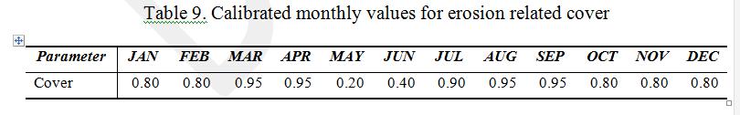
12 Methods Model Setup Six hydrologic respond units - HRUs based on similarity of land cover and hydrologic soil groups HSGs. Detailed crop management information (tillage, fertilization, harvest) was found in Yuan et al. (2001) and Yuan and Bingner (2002). USGS site-collected 15-minute rainfall data were used in this study. Hourly climate time series (maximum and minimum air temperatures, dew point, wind, solar ration, and cloud cover) were extracted from the NOAA Greenwood Leflore Airport station, located 16.7 km from the drainage area. All climate data were converted to 15- minute time series by equally dividing the hourly values. only pervious land segment algorithms (water budget and runoff components; sediment production and removal; and phosphorus fate & runoff) were used in this research. Phosphorus transformations were simulated using the PHOS AGCHEM module.


13 Methods Phosphorus Processes Cotton phosphate uptake was set at 2.77 kg/ha (Yuan and Bingner, 2002). Soybean phosphate uptake was set at kg/ha (Yuan and Bingner, 2002). Winter wheat phosphate was set at 4.49 kg/ha (Liu, 2006). Monthly fractions of total annual P uptake were developed using data from Liu (2006) for soybean and winter wheat and from Schwab et al. (2000) for cotton. The soil layer fraction of monthly uptake rate was developed based on the crop growth stage and the typical depth of crop root. It was assumed that more than 90% of the monthly phosphate uptake came from upper and lower soil layers. The amount of uptake in the groundwater zone was set as zero.


, the coefficient of determination (R 2 ),")
14 Methods Approach for Model Calibration and Validation Model outputs were evaluated against runoff, total suspended sediments, and dissolved & total phosphorus time series collected at the outlet of the drainage area by USGS (USGS Unknown Lake Tributary No 2 Near Sidon, MS). Model parameter calibration was performed from January 1, 1997 to December 31, Validation was performed using the USGS runoff, sediments, and phosphorus data and on site precipitation time series from January 1, 1999 to December 31, Model Evaluation Numerical criteria: the relative error (RE), the root mean square error (RMSE), the coefficient of determination (R 2 ), and the Nash-Sutcliffe coefficient (NS). Scatter plots were used to evaluate observed versus simulated variables.


15 Results Hydrologic Processes: Runoff Calibration 45 storm events, NS = 0.85


16 Results Hydrologic Processes: Runoff Validation 15 storm events,1999. NS = 0.86

")


17 Results Hydrologic Processes: Seasonal and Long-Term Runoff Performance Closed values Total runoff values by month ( ) The R 2 and NS goodness-of-fit values of 0.94 and 0.84, respectively were very good indications of the robustness of the HSPF model in simulating rainfall-runoff processes at the farm scale in the Mississippi Delta region.


18 Results Soil Erosion Processes: Calibration of Suspended Sediment Loads Soil detachment washoff 29 storm events,


19 Results Soil Erosion Processes: Validation of Suspended Sediment Loads 11 storm events, 1999

, it was found that herbicide")


20 Results Soil Erosion Processes: Seasonal and Long-Term Sediment Load Performance From the field report published by Yuan and Bingner (2002), it was found that herbicide was applied early on June every year. However, no additional soil detachment values were input into the model. Total suspended sediment load by month, The model was able to simulate close values in the wet season (December and January) and dry season (October).


21 Results Phosphorus Processes: Calibration and Validation of Dissolved Phosphorus Loads 23 storm events, NS = 0.51 Period R 2 NS Calibration Validation


22 Results Phosphorus Processes: Calibration and Validation of Total Phosphorus Loads 23 storm events, NS = 0.11 Period R 2 NS Calibration Validation


23 Results Seasonal and Long-Term Dissolved Phosphorus Load Performance Dissolved P load by month, R 2 NS Monthly Annual


24 Results Seasonal and Long-Term Total Phosphorus Load Performance Low simulated TSS TP load by month, R 2 NS Monthly Annual Without June data


25 Results Model Limitations Ponding at the outlet of the drainage area was not simulated There is no particle discretization of HSPF soil erosion values from land surface. Although organic residues were left in the fields as conservation tillage practice, the effects of crop residue on phosphorus concentrations in runoff were not simulated. Irrigation was scheduled in the study area but the model did not simulate it. Runoff and sediment from irrigation could deplete the phosphorus pools in the study area. Atmospheric deposition of phosphorus was not simulated.
26 Conclusions The study demonstrated that the HSPF model is a capable modeling tool for evaluating runoff, soil erosion, and total phosphorus processes at the farm scale in the Mississippi alluvial valley, mainly for analysis on long term basis (monthly, seasonal, or annual). Results from this study are significant at the scale of this drainage area (11.29 ha), but more study is needed to determine whether processes are accurately predicted. The results of this research would be helpful in providing initial parameter values and guidelines for future applications of HSPF in similar agricultural drainage areas in the Mississippi Delta region.
27 Acknowledgments This research was performed with funding from the Mississippi Department of Marine Resources project: Watershed Assessment Tools: MS Delta Evaluation. We like to thank Dr. Ronald Bingner from USDA-ARS-NSL for supplying GIS data and information of the Deep Hollow area. Special thanks to Germania Salazar, Matt Moran, and Alina Young, former MSU-CEE graduate students funded by this project, for helping in model setup and time series analysis.


28 Thanks! Jairo Diaz Director Mississippi River Research Center Alcorn State University
Application of AnnAGNPS to model an agricultural watershed in East-Central Mississippi for the evaluation of an on-farm water storage (OFWS) system
 system") Application of AnnAGNPS to model an agricultural watershed in East-Central Mississippi for the evaluation of an on-farm water storage (OFWS) system Ritesh Karki a, Mary Love M. Tagert a, Joel O. Paz a,
Application of AnnAGNPS to model an agricultural watershed in East-Central Mississippi for the evaluation of an on-farm water storage (OFWS) system Ritesh Karki a, Mary Love M. Tagert a, Joel O. Paz a,
Modeling Nutrient and Sediment Losses from Cropland D. J. Mulla Dept. Soil, Water, & Climate University of Minnesota
 Modeling Nutrient and Sediment Losses from Cropland D. J. Mulla Dept. Soil, Water, & Climate University of Minnesota Watershed Management Framework Identify the problems and their extent Monitor water
Using AnnAGNPS to Evaluate On-Farm Water Storage Systems (OFWS) as a BMP for Nutrient Loading Control in a Small Watershed in East Mississippi
 as a BMP for Nutrient Loading Control in a Small Watershed in East Mississippi") Using AnnAGNPS to Evaluate On-Farm Water Storage Systems (OFWS) as a BMP for Nutrient Loading Control in a Small Watershed in East Mississippi Ritesh Karki Graduate Student, Mississippi State University
Using AnnAGNPS to Evaluate On-Farm Water Storage Systems (OFWS) as a BMP for Nutrient Loading Control in a Small Watershed in East Mississippi Ritesh Karki Graduate Student, Mississippi State University
Modeling the Impacts of Agricultural Conservation Strategies on Water Quality in the Des Moines Watershed
 Modeling the Impacts of Agricultural Conservation Strategies on Water Quality in the Des Moines Watershed Presenter: Jeff Arnold, Supervisory Research Engineer, USDA-ARS C. Santhi, M. White, M. Di Luzio
A Century of Precipitation Trends in the Mississippi Delta Region and Implications for Agroecosystem Management
 A Century of Precipitation Trends in the Mississippi Delta Region and Implications for Agroecosystem Management LINDSEY YASARER, RESEARCH HYDROLOGIST WATER QUALITY AND ECOLOGY RESEARCH UNIT USDA-ARS NATIONAL
Table of Contents. Table of Figures
 Appendix A: Modeling Report Little Manatee WBID: 1790 Nutrients and Dissolved Oxygen September 30, 2009 Table of Contents 1. WATERSHED DESCRIPTION... 1 2. TMDL TARGETS... 2 3. MODELING APPROACH... 2 3.1.
Evaluating a Vegetated Filter Strip in Agricultural Field
 Evaluating a Vegetated Filter Strip in Agricultural Field BY ALINA YOUNG MISSISSIPPI WATER RESOURCES CONFERENCE DEPARTMENT OF CIVIL ENGINEERING MISSISSIPPI STATE, MISSISSIPPI APRIL 4, 2012 Outline Introduction
APPLICATION OF THE SWAT (SOIL AND WATER ASSESSMENT TOOL) MODEL IN THE RONNEA CATCHMENT OF SWEDEN
 MODEL IN THE RONNEA CATCHMENT OF SWEDEN") Global NEST Journal, Vol 7, No 3, pp 5-57, 5 Copyright 5 Global NEST Printed in Greece. All rights reserved APPLICATION OF THE SWAT (SOIL AND WATER ASSESSMENT TOOL) MODEL IN THE RONNEA CATCHMENT OF SWEDEN
Global NEST Journal, Vol 7, No 3, pp 5-57, 5 Copyright 5 Global NEST Printed in Greece. All rights reserved APPLICATION OF THE SWAT (SOIL AND WATER ASSESSMENT TOOL) MODEL IN THE RONNEA CATCHMENT OF SWEDEN
SWAT modeling of Arroyo Colorado watershed
 SWAT modeling of Arroyo Colorado watershed Narayanan Kannan Texas AgriLife Research (Texas A&M University System) Temple Need for the project Arroyo Colorado failed to meet Texas water quality standards
Modeling the Urban Stormwater (and the rest of the watershed) Katherine Antos, Coordinator Water Quality Team U.S. EPA Chesapeake Bay Program Office
 Katherine Antos, Coordinator Water Quality Team U.S. EPA Chesapeake Bay Program Office") Modeling the Urban Stormwater (and the rest of the watershed) Katherine Antos, Coordinator Water Quality Team U.S. EPA Chesapeake Bay Program Office May 13, 2010 Management Actions Chesapeake Bay Program
Modeling the Urban Stormwater (and the rest of the watershed) Katherine Antos, Coordinator Water Quality Team U.S. EPA Chesapeake Bay Program Office May 13, 2010 Management Actions Chesapeake Bay Program
Modeling watershed nutrient fluxes & delivery to coastal waters. Pennsylvania State University. Collaborators
 Modeling watershed nutrient fluxes & delivery to coastal waters Elizabeth W. Boyer Pennsylvania State University Collaborators Richard Alexander Gregory Schwarz Richard Smith US Geological Survey National
National Agricultural Pesticide Risk Assessment (NAPRA) Web
 Web") The NAPRA Program 1 Acushla Antony 2, Indrajeet Chaubey, Bernard Engel, Natalie Carroll 2 Respectively, Graduate student, Professor, Professor and Head, and Professor, Department of Agricultural and Biological
The NAPRA Program 1 Acushla Antony 2, Indrajeet Chaubey, Bernard Engel, Natalie Carroll 2 Respectively, Graduate student, Professor, Professor and Head, and Professor, Department of Agricultural and Biological
A Comparison of SWAT and HSPF Models for Simulating Hydrologic and Water Quality Responses from an Urbanizing Watershed
 Paper Number: 032175 An ASAE Meeting Presentation A Comparison of SWAT and HSPF Models for Simulating Hydrologic and Water Quality Responses from an Urbanizing Watershed S. Im, Post-doc Research Associate
History of Model Development at Temple, Texas. J. R. Williams and J. G. Arnold
 History of Model Development at Temple, Texas J. R. Williams and J. G. Arnold INTRODUCTION Then Model development at Temple A long history (1937-present) Many scientists participating in: Data collection
Application of the PRMS model in the Zhenjiangguan watershed in the Upper Minjiang River basin
 doi:10.5194/piahs-368-209-2015 Remote Sensing and GIS for Hydrology and Water Resources (IAHS Publ. 368, 2015) (Proceedings RSHS14 and ICGRHWE14, Guangzhou, China, August 2014). 209 Application of the
Appendix 12. Pollutant Load Estimates and Reductions
 Appendix 12. Pollutant Load Estimates and Reductions A pollutant loading is a quantifiable amount of pollution that is being delivered to a water body. Pollutant load reductions can be calculated based
Simplified Forms of Surface Runoff Estimation Method for Silt- Loam Soils Suat Irmak, Soil and Water Resources and Irrigation Engineer, Professor
 EC3016 Index: Crops, Irrigation Engineering Issued April 2017 Simplified Forms of Surface Runoff Estimation Method for Silt- Loam Soils Suat Irmak, Soil and Water Resources and Irrigation Engineer, Professor
TMDL Data Requirements for Agricultural Watersheds
 This is not a peer-reviewed article. Pp. 408-415 in Total Maximum Daily Load (TMDL) Environmental Regulations: Proceedings of the March 11-13, 2002 Conference, (Fort Worth, Texas, USA) Publication Date
Toward a Great Lakes Watershed Ecological Sustainability Strategy (GLWESS): Modeling Workshop. Lansing, MI May 3, 2012
: Modeling Workshop. Lansing, MI May 3, 2012") Toward a Great Lakes Watershed Ecological Sustainability Strategy (GLWESS): Modeling Workshop Lansing, MI May 3, 2012 Presentation Outline Overview of ecological concerns General modeling overview How
Toward a Great Lakes Watershed Ecological Sustainability Strategy (GLWESS): Modeling Workshop Lansing, MI May 3, 2012 Presentation Outline Overview of ecological concerns General modeling overview How
Modeling Sediment and Nutrient Loads Input to Great Lakes and Effects of Agricultural Conservation Practices on Water Quality
 Modeling Sediment and Nutrient Loads Input to Great Lakes and Effects of Agricultural Conservation Practices on Water Quality C. Santhi and CEAP National Assessment Team Texas A&M University System, Temple,
Chapter 2: Conditions in the Spring Lake Watershed related to Stormwater Pollution
 Chapter 2: Conditions in the Spring Lake Watershed related to Stormwater Pollution To identify the primary causes and consequences of stormwater discharges to Spring Lake and its adjoining waterbodies,
Models Overview: Purposes and Limitations
 Models Overview: Purposes and Limitations Pollutant load originates from: Point-source discharges (NPDES facilities) Info is available on the discharges (DMRs, etc.) Some are steady-flow, others are precip-driven
Evaluating the Least Cost Selection of Agricultural Management Practices in the Fort Cobb Watershed
 Evaluating the Least Cost Selection of Agricultural Management Practices in the Fort Cobb Watershed Solmaz Rasoulzadeh*, Arthur Stoecker Daniel E. Storm *PhD student, Biosystems and Agricultural Engineering
Modeling Sediment and Nutrient Loads Input to Chesapeake Bay and Effects of Agricultural Conservation Practices on Water Quality
 Modeling Sediment and Nutrient Loads Input to Chesapeake Bay and Effects of Agricultural Conservation Practices on Water Quality C. Santhi and CEAP National Assessment Team Texas A&M University System,
A Modeling Framework for Linking Urban Stormwater Load Allocation, Implementation Plan, and BMP Design. Sen Bai, PhD, PE Jon Ludwig
 A Modeling Framework for Linking Urban Stormwater Load Allocation, Implementation Plan, and BMP Design Sen Bai, PhD, PE Jon Ludwig Outline Background Modeling for non-point source management Modeling framework
WEPP Simulated Tillage Effects on Runoff and Sediment Losses in a Corn-Soybean Rotation
 This paper was peer-reviewed for scientific content. Pages 877-881. In: D.E. Stott, R.H. Mohtar and G.C. Steinhardt (eds). 2001. Sustaining the Global Farm. Selected papers from the 10th International
Downstream Water Quality and Quantity Impacts Of Water Storage Systems in a Mississippi Delta Watershed
 Downstream Water Quality and Quantity Impacts Of Water Storage Systems in a Mississippi Delta Watershed Mary Love M. Tagert, Joel O. Paz, Jonathan W. Pote, and Richard L. Kirmeyer Mississippi State University
Climate Simulation Irrigation Winter Processes Surface Hydrology Water Balance & Percolation Subsurface Hydrology Soil Component Plant Growth Residue
 Climate Simulation Irrigation Winter Processes Surface Hydrology Water Balance & Percolation Subsurface Hydrology Soil Component Plant Growth Residue Decomposition and Management Overland Flow Hydraulics
Hydrologic Model of the Vermilion River Watershed for Streamflow Simulations
 This project was funded through the Illinois Department of Natural Resources and the Illinois State Geological Survey. Illinois State Water Survey Contract Report 2004-0. Hydrologic Model of the Vermilion
The Hypoxic Zone in the Gulf of Mexico
 The Hypoxic Zone in the Gulf of Mexico References Council Committee on Environmental and Natural Resources. 2003. An Assessment of Coastal Hypoxia and Eutrophication in U.S. Water. National Science and
Phase 6 Watershed Model Beta 4 Modeling Workgroup Quarterly Meeting Dec 2016
 12/13/2016 Phase 6 Watershed Model Beta 4 Modeling Workgroup Quarterly Meeting Dec 2016 Gopal Bhatt 1 and Gary Shenk 2 1 Penn State University, 2 USGS Presentation Outline A brief summary of input data
GreenPlan Modeling Tool User Guidance
 GreenPlan Modeling Tool User Guidance Prepared by SAN FRANCISCO ESTUARY INSTITUTE 4911 Central Avenue, Richmond, CA 94804 Phone: 510-746-7334 (SFEI) Fax: 510-746-7300 www.sfei.org Table of Contents 1.
Spring Nutrient Flux to the Gulf of Mexico and Nutrient Balance in the Mississippi River Basin
 Spring Nutrient Flux to the Gulf of Mexico and Nutrient Balance in the Mississippi River Basin C.S. Snyder, PhD, CCA Nitrogen Program Director, Conway, AR T. Scott Murrell, PhD Director, North American
The national-level nutrient loading estimation tool for Finland: Watershed Simulation and Forecasting System WSFS-Vemala
 The national-level nutrient loading estimation tool for Finland: Watershed Simulation and Forecasting System WSFS-Vemala Markus Huttunen, Finnish Environment Institute SYKE, HELCOM workshop on transboundary
Chesapeake Bay Program Models:
 Chesapeake Bay Program Models: A Guide to Better Understanding Modeling and Decision Support Tool Forum Penn State Harrisburg August 1, 2011 1 Mark Dubin Agricultural Technical Coordinator University of
PHOSPHORUS DYNAMICS & POLLUTION
 PHOSPHORUS DYNAMICS & POLLUTION (Source of some of the notes Zaimes & Shultz 2002 Phosphorus literature review Sharpley et al. 1999 Agricultural phosphorus & eutrophication) Introduction A major player
Use of SWAT for Urban Water Management Projects in Texas
 Use of SWAT for Urban Water Management Projects in Texas Jaehak Jeong and Allan Jones Texas AgriLife Research Presentation Outline Modeling of Urban Watersheds and Stormwater Best Management Practices
1 THE USGS MODULAR MODELING SYSTEM MODEL OF THE UPPER COSUMNES RIVER
 1 THE USGS MODULAR MODELING SYSTEM MODEL OF THE UPPER COSUMNES RIVER 1.1 Introduction The Hydrologic Model of the Upper Cosumnes River Basin (HMCRB) under the USGS Modular Modeling System (MMS) uses a
Soil and Water Assessment Tool. R. Srinivasan Texas A&M University
 Soil and Water Assessment Tool R. Srinivasan Texas A&M University Model Philosophy Readily available input Physically based Comprehensive Process Interactions Simulate Management ARS Modeling History Time
Chapter 1 Introduction
 Engineering Hydrology Chapter 1 Introduction 2016-2017 Hydrologic Cycle Hydrologic Cycle Processes Processes Precipitation Atmospheric water Evaporation Infiltration Surface Runoff Land Surface Soil water
Summary of Water Monitoring Data
 Clay County Drainage Site Summary of Water Monitoring Data 2011 2015 Introduction The Red River Valley in northwestern Minnesota is experiencing an increase in the amount of agricultural subsurface drainage
Retrospective analysis of hydrologic impacts in the Chesapeake Bay watershed
 Retrospective analysis of hydrologic impacts in the Chesapeake Bay watershed Harsh Beria1,3, Rob Burgholzer2, Venkat Sridhar3 Indian Institute of Technology Kharagpur, India & Summer intern Virginia Department
AnnAGNPS. Annualized AGricultural Non-Point Source Pollurant Loading Model. Annualized Agricultural Non-Point Source Pollutant Loading Model
 AnnAGNPS Annualized AGricultural Non-Point Source Pollurant Loading Model 1 Erosion Erosion can be expresed as: E=f(C, S, T, SS, M) E = erosion C = climate S = soil properties T = topography SS = soil
Environmental Risk Assessment under Environmental Standard and Safety-First Constraints
 Environmental Risk Assessment under Environmental Standard and Safety-First Constraints Walaiporn Intarapapong, Postdoctoral Research Assistant Department of Agricultural Economics, Mississippi State University
SENSITIVITY OF HSPF- ESTIMATED FLOWRATE TO TOPOGRAPHICAL PARAMETER VALUES FOR A COASTAL WATERSHED IN MISSISSIPPI
 SENSITIVITY OF HSPF- ESTIMATED FLOWRATE TO TOPOGRAPHICAL PARAMETER VALUES FOR A COASTAL WATERSHED IN MISSISSIPPI Vladimir J. Alarcon* Chuck O Hara* William McAnally** James Martin** Jairo Diaz** Zhiyong
Strategies for nitrate reduction: The Cedar River Case Study
 2010 Integrated Crop Management Conference - Iowa State University 195 Strategies for nitrate : The Cedar River Case Study Matthew J. Helmers, associate professor, Agricultural and Biosystems Engineering,
Modeling the Effects of Agricultural Conservation Practices on Water Quality in the Pacific Northwest Basin
 Modeling the Effects of Agricultural Conservation Practices on Water Quality in the Pacific Northwest Basin Presenter: R. Srinivasan, Professor, Texas A&M C. Santhi and CEAP National Assessment Team Texas
WATER RESOURCES MANAGEMENT Vol. II - Watershed Modeling For Water Resource Management - D. K. Borah WATERSHED MODELING FOR WATER RESOURCE MANAGEMENT
 WATERSHED MODELING FOR WATER RESOURCE MANAGEMENT D. K. Borah Borah Hydro-Environmental Modeling, Champaign, Illinois, USA Keywords: Agriculture, agrochemical, BMP, hydrology, long-term continuous model,
Bob Broz University of Missouri Extension
 Bob Broz University of Missouri Extension brozr@missouri.edu 573-882-0085 What is the purpose on the nutrient reduction committee? Reduce nutrient loading into the Mississippi River and into the Gulf of
Salt Lake County Watershed Water Quality Model
 Salt Lake County Watershed Water Quality Model Watershed Symposium August 5, 2010 Presenters: Nicholas von Stackelberg Bryan Close Slide 1 Presentation Overview Background and Model Objectives (Nick) Model
Opti-Tool: A BMP Optimization Tool for Stormwater Management in EPA Region 1
 Opti-Tool: A BMP Optimization Tool for Stormwater Management in EPA Region 1 Mark Voorhees, EPA Region 1 Khalid Alvi, Tetra Tech April 20, 2016 Project Background Massachusetts (MA) MS4 General Permit
4R Phosphorus Management for Sustainable Crop Nutrition
 MVTL 2018 Agronomy Update New Ulm, MN February 1, 2018 4R Phosphorus Management for Sustainable Crop Nutrition Heidi Peterson Phosphorus Program Director Stillwater, Minnesota hpeterson@ipni.net The International
Nutrient Management in. A presentation to the West Metro Water Alliance
 Nutrient Management in Developing and Agricultural Areas A presentation to the West Metro Water Alliance Chris Meehan, P.E. May 25, 2011 Agenda Physical Improvements Planning Improvements How to get it
Precipitation Surface Cover Topography Soil Properties
 Precipitation Surface Cover Topography Soil Properties Intrinsic capacity of rainfall to cause erosion Influenced by Amount, intensity, terminal velocity, drop size and drop size distribution of rain.
Hydrology 101. Impacts of the Urban Environment. Nokomis Knolls Pond Summer June 2008
 Hydrology 101 Nokomis Knolls Pond Summer 2002 Impacts of the Urban Environment Hydrologic Cycle; What is it? Geography, Topography, Geology, Land Cover and Climate determine the Amount and Behavior of
Lake of the Woods TMDL: Update and Next Steps November 21, 2017
 Lake of the Woods TMDL: Update and Next Steps November 21, 2017 Outline Where we ve been (2016) HSPF Bathtub Internal loading estimation Progress in 2017 Development of TMDL load allocation table Next
Ch 18. Hydrologic Cycle and streams. Tom Bean
 Ch 18. Hydrologic Cycle and streams Tom Bean Wednesday s outline 1. the hydrologic cycle reservoirs cycling between them Evaporation and the atmosphere 2. Surface hydrology infiltration and soil moisture
Calibrating the Soquel-Aptos PRMS Model to Streamflow Data Using PEST
 Calibrating the Soquel-Aptos PRMS Model to Streamflow Data Using PEST Cameron Tana Georgina King HydroMetrics Water Resources Inc. California Water Environmental and Modeling Forum 2015 Annual Meeting
Development of a watershed modelling approach to assess the impacts of biofuel feedstock on water quality in the Upper Mississippi River Basin
 Water Pollution XII 357 Development of a watershed modelling approach to assess the impacts of biofuel feedstock on water quality in the Upper Mississippi River Basin D. J. Lampert & M. M. Wu Argonne National
Modelling agricultural nutrient loading from Finnish watersheds
 Modelling agricultural nutrient loading from Finnish watersheds Inese Huttunen, Markus Huttunen, Marie Korppoo, Bertel Vehviläinen, SYKE Maataloustieteen päivät 2018 10-11.1.2018 Viikki, Helsinki Contents
Modelling of the Hydrology, Soil Erosion and Sediment transport processes in the Lake Tana Catchments of Blue Nile River Basin, Ethiopia
 Modelling of the Hydrology, Soil Erosion and Sediment transport processes in the Lake Tana Catchments of Blue Nile River Basin, Ethiopia Combining Field Data, Mathematical Models and Geographic Information
Nutrient Management for Vegetable Production
 Nutrient Management for Vegetable Production Richard Smith, Farm Advisor Monterey County Farm Water Quality Planning Project UC Cooperative Extension/ USDA Natural Resources Conservation Service Fertilizers
INFLUENCE OF LAND USE/LAND COVER CHANGE ON SAINT LOUIS BAY WATERSHED MODELING
 Journal of Coastal research SI 52 INFLUENCE OF LAND USE/LAND COVER CHANGE ON SAINT LOUIS BAY WATERSHED MODELING Author 1, Zhiyong Duan Author 2, Jairo N. Diaz Author 3, James L. Martin Author 4, William
WaterTech 2015 Total Loading Management Plan - An Integrated Watershed Management Approach. Lily Ma, The City of Calgary April, 2015
 WaterTech 2015 Total Loading Management Plan - An Integrated Watershed Management Approach Lily Ma, The City of Calgary April, 2015 Presentation Outline History of City of Calgary s TLMP and BRWQM TLMP
Columbia, Missouri. Contents
 Supplemental Material to Accompany: Long-term Agro-ecosystem Research in the Central Mississippi River Basin, USA - SWAT Simulation of Flow and Water Quality in the Goodwater Creek Experimental Watershed
Watershed Modeling of Copper Loads to San Francisco Bay
 Watershed Modeling of Copper Loads to San Francisco Bay Tony Donigian AQUA TERRA Consultants Brake Pad Partnership Stakeholder Conference July 31, 2007 Watershed Model Objectives - Provide daily loadings
Protocol for Calibration of River Basins using SWAT
 Improving Life through Science and Technology. Protocol for Calibration of River Basins using SWAT N.Kannan Co authors: M. White, C. Santhi, X. Wang, J.G. Arnold, and M. Di Luzio The Context Insufficient
The Effect of Cover Crops on Surface Water Quality: A Paired Watershed Experiment in the Lake Bloomington Watershed.
 The Effect of Cover Crops on Surface Water Quality: A Paired Watershed Experiment in the Lake Bloomington Watershed. February, 2017 Submitted by: Catherine O Reilly, Shalamar Armstrong, and Bill Perry
USING ARCSWAT TO EVALUATE EFFECTS OF LAND USE CHANGE ON WATER QUALITY. Adam Gold Geog 591
 USING ARCSWAT TO EVALUATE EFFECTS OF LAND USE CHANGE ON WATER QUALITY Adam Gold Geog 591 Introduction The Soil and Water Assessment Tool (SWAT) is a hydrologic transport model with an objective to predict
WASA Quiz Review. Chapter 2
 WASA Quiz Review Chapter 2 Question#1 What is surface runoff? part of the water cycle that flows over land as surface water instead of being absorbed into groundwater or evaporating Question #2 What are
What is the Water telling Us about the Land?
 What is the Water telling Us about the Land? This Morning Rain Land Water This Morning The Water Precipitation Soil Water Groundwater Streams Lakes The Water Let s explore how these are connected! Hydrologic
Draft Phase 6 Watershed Model Updates Modeling Workgroup Conference Call May 2017
 05/18/2017 Draft Phase 6 Watershed Model Updates Modeling Workgroup Conference Call May 2017 Gopal Bhatt 1 and Gary Shenk 2 1 Penn State, 2 USGS Presentation Outline Brief overview of the Phase 6 draft
Application of the SWAT Hydrologic Model for Urban Stormwater Management
 UT Arlington, June 5 th, 2015 Application of the SWAT Hydrologic Model for Urban Stormwater Management Jaehak Jeong, PhD, PE Assistant Professor Texas A&M AgriLife Research Texas A&M University Roger Glick,
Degradation of the resource Fertility loss Organic matter Tilth degradation. Water quality Sediment Nutrients
 Near Blue River ca. 1980 Degradation of the resource Fertility loss Organic matter Tilth degradation Water quality Sediment Nutrients Program cost Cheaper to prevent Still expensive Long-term productivity
5. Basin Evaluation Salt and Nitrate Balance
 SNMP Attachment B, Section B.2.1.3 (originally Section 5 in CV-SALTS Phase 2 Conceptual Model Task 5 deliverables) 5. As part of the evaluation of water quality the SNMP requires loading estimates and
Natural Resources & Environmental Stewardship
 Natural Resources & Environmental Stewardship Fundamentals of Nutrient Management Melissa L. Wilson Department of Environmental Science & Technology Ag Nutrient Management Program University of Maryland,
EVALUATING LOW IMPACT DEVELOPMENT BEST MANAGEMENT PRACTICES AS AN ALTERNATIVE TO TRADITIONAL URBAN STORMWATER MANAGEMENT
 EVALUATING LOW IMPACT DEVELOPMENT BEST MANAGEMENT PRACTICES AS AN ALTERNATIVE TO TRADITIONAL URBAN STORMWATER MANAGEMENT Brandon Holzbauer-Schweitzer Region 6 Stormwater Conference 10/05/2016 Introduction
SUPPORTING CHESAPEAKE BAY RESTORATION BY MODELING NUTRIENT AND SEDIMENT SOURCES AND TRANSPORT
 SUPPORTING CHESAPEAKE BAY RESTORATION BY MODELING NUTRIENT AND SEDIMENT SOURCES AND TRANSPORT Applications and Results of SPARROW Models John W. Brakebill jwbrakeb@usgs.gov Scott W. Ator swator@usgs.gov
Hands-on Session. Adrian L. Vogl Stanford University
 Hands-on Session Adrian L. Vogl Stanford University avogl@stanford.edu Questions InVEST can answer How much water is available? Where does the water used for hydropower production come from? How much energy
Chesapeake Bay Program Indicator Analysis and Methods Document Reducing Pollution Indicators Updated May 2018
 1 Chesapeake Bay Program Indicator Analysis and Methods Document Reducing Pollution Indicators Updated May 2018 Indicator Title: Reducing Pollution Relevant Outcome(s): 2017 Watershed Implementation Plans
Overview of Gulf of Mexico Hypoxia Policy in Doug Daigle Lower Mississippi River Sub-basin Committee
 Overview of Gulf of Mexico Hypoxia Policy in 2017 Doug Daigle Lower Mississippi River Sub-basin Committee Mississippi Water Resources Conference April 12, 2017 Jackson, MS Nutrient Yields from the Mississippi
Little River Watershed Conservation Practice Assessment with SWAT. D.D. Bosch, J. Cho, G. Vellidis, R. Lowrance, T. Strickland
 Little River Watershed Conservation Practice Assessment with SWAT D.D. Bosch, J. Cho, G. Vellidis, R. Lowrance, T. Strickland Outline Background Impacts of riparian forest buffer (RFB) Allocating Best
Evaluation of Constructed Wetlands as Mitigation Options for Phosphorus and Sediment within UK Agriculture
 Evaluation of Constructed Wetlands as Mitigation Options for Phosphorus and Sediment within UK Agriculture Clare Deasy* and John Quinton Lancaster Environment Centre, Lancaster University, Lancaster, LA1
A Nutrient Mass Balance of the Watershed Research and Education Center: Where, When and How Much?
 A Nutrient Mass Balance of the Watershed Research and Education Center: Where, When and How Much? BRIAN E. HAGGARD, JOHN T. METRAILER, DIRK PHILIPP, J. VAUGHN SKINNER, J. THAD SCOTT, AND ANDREW N. SHARPLEY
Tropical Agro-Ecosystem Function
 Tropical Agro-Ecosystem Function Soil erosion by water and wind Dr. Ronald F. Kühne; rkuehne@gwdg.de Georg-August-University Göttingen Department for Crop Sciences Tropical Agronomy Grisebachstr. 6, 37077
Assessing Regional Water Impacts of Biofuel Production Scenarios
 Assessing Regional Water Impacts of Biofuel Production Scenarios May Wu, Yonas Demissie, Eugene Yan Argonne National Laboratory GWPC Annual Forum Water and Energy Sustainability Sept. 26-29, 2010 Pittsburgh,
Rapid National Model Assessments to Support US Conservation Policy Planning Mike White
 Rapid National Model Assessments to Support US Conservation Policy Planning Mike White USDA-ARS Grassland, Soil and Water Research Laboratory, Temple, TX 1 Topics Current National Assessments Future National
Yoshinaga Ikuo *, Y. W. Feng**, H. Hasebe*** and E. Shiratani****
 NITROGEN REMOVAL FUNCTION OF PADDY FIELD IN A CIRCULAR IRRIGATION SYSTEM Yoshinaga Ikuo *, Y. W. Feng**, H. Hasebe*** and E. Shiratani**** * National Institute for Rural Engineering, Tsukuba Science City
NUTRIENT TRACKING TOOL
 NUTRIENT TRACKING TOOL A Cooperative Project Between Texas Institute for Applied Environmental Research (TIAER) USDA NRCS USDA ARS US EPA Funding support for this project was provided in part through a
Modelling Ecosystem Services in Ontario and Canada Wanhong Yang
 Modelling Ecosystem Services in Ontario and Canada Wanhong Yang November 20, 2014 Wetland Ecological Goods and Services Valuation Project (LSCF Round 4, 2009) Objective: Utilizing the collaborative expertise
Heather L. Welch US Geological Survey, Lower Mississippi-Gulf Water Science Center
 Contribution of total dissolved phosphorus in irrigation runoff from the Mississippi River valley alluvial aquifer to phosphorus concentrations in a Delta stream Heather L. Welch US Geological Survey,
Ag Drainage Design Protocols and Current Technology
 Department of Agricultural and Biosystems Engineering Ag Drainage Design Protocols and Current Technology Matthew Helmers Dean s Professor, College of Ag. & Life Sciences Associate Professor, Dept. of
The Phosphorus Management Tool
 The Phosphorus Management Tool Heather Hutchinson Nutrient Management Specialist June 18, 2013 Understanding Phosphorus Why are soils high in phosphorus? Why is phosphorus a problem? How is phosphorus
Comparison of Lumped and Distributed Hydrologic Models for the Runoff Simulation of a Large Watershed in Alabama and Mississippi
 Comparison of Lumped and Distributed Hydrologic Models for the Runoff Simulation of a Large Watershed in Alabama and Mississippi Jairo N. Diaz-Ramirez Billy E. Johnson William H. McAnally James L. Martin
Chesapeake Bay Program Watershed Modeling. Gary Shenk, Lewis Linker, Rich Batiuk Presentation to STAC 3/22/2011
 Chesapeake Bay Program Watershed Modeling Gary Shenk, Lewis Linker, Rich Batiuk Presentation to STAC 3/22/2011 1 Chesapeake Bay Partnership Models 2 Recent History of the Chesapeake Bay Program s Watershed
Objectives of the Study
 Integration of AGNPS, GIS, and Remote Sensing for Estimating Nonpoint Source Pollution in the Saginaw Bay, Michigan Chansheng He Department of Geograophy Western Michigan University Kalamazoo, MI 49008
Modeling soil P. Case study focusing on the Soil and Water Assessment Tool (SWAT) and ongoing research. Margaret Kalcic, Grey Evenson, Rebecca Muenich
 and ongoing research. Margaret Kalcic, Grey Evenson, Rebecca Muenich") Modeling soil P Case study focusing on the Soil and Water Assessment Tool (SWAT) and ongoing research Margaret Kalcic, Grey Evenson, Rebecca Muenich Phosphorus Field to Watershed Modeling Workshop, August
Modeling soil P Case study focusing on the Soil and Water Assessment Tool (SWAT) and ongoing research Margaret Kalcic, Grey Evenson, Rebecca Muenich Phosphorus Field to Watershed Modeling Workshop, August
Phosphorus Risk Assessment Index Evaluation Using Runoff Measurements
 Volume 8, Number 1 Phosphorus Risk Assessment Index Evaluation Using Runoff Measurements Bahman Eghball and John E. Gilley USDA-ARS, Lincoln, NE Introduction Manure and composted manure are valuable and
New Practices for Nutrient Reduction: STRIPs and Saturated Buffers. Matthew Helmers and Tom Isenhart Iowa State University
 New Practices for Nutrient Reduction: STRIPs and Saturated Buffers Matthew Helmers and Tom Isenhart Iowa State University Situation Increasing concern for local and regional waters Substantial demand for