2018 Platte River Power Authority Water Resources Reference Document
|
|
|
- Asher Tate
- 6 years ago
- Views:
Transcription


1 2018 Platte River Power Authority Water Resources Reference Document 2 nd Edition Published: April 26, 2018 A white paper outlining Platte River Power Authority s water supply, background, activity, agreements and operational historical performance
2
3 Platte River Water Resources Reference Document Table of Contents I. Background and History 1. Why Platte River Needs Water Water Supply Sources Water Agreements and Decrees Current Annual Water Use Water Costs Capital and Operating II. Current Activity - The Windy Gap Firming Project 1. The Critical Nature of Water Supply to Generation Operations and Windy Gap Project Performance History and Status of Windy Gap Firming Project Next Steps for the Firming Project Firming Project Schedule Determination of Firming Storage Requirements Firming Project Participants Firming Project Costs Operation of the Firming Reservoir III. Past Water Policy and Operations 1. Water Policy Background a. Securing and protecting water for Platte River operational needs b. Planning for Platte River s future water supply needs c. Leveraging the value for water resources through leasing IV. Current Water Policy V. Going Forward Appendix A Maps 1. Northern Water: Colorado-Big Thompson Project 2. Northern Water: Water Collection and Distribution Systems 3. Northern Water: West Slope Collection System 4. Northern Water: East Slope Distribution System 5. Platte River Water System Reference Map (Water Interests) 6. Windy Gap Firming Project: Chimney Hollow Reservoir Appendix B Reference Materials 1. Platte River Water Agreement and Water Decree List 2. Water Consumption Forecasting 3. Windy Gap Firming Project - Model Analysis (Heather Thompson Study) Appendix C Water Resources Policy Appendix D Glossary
4
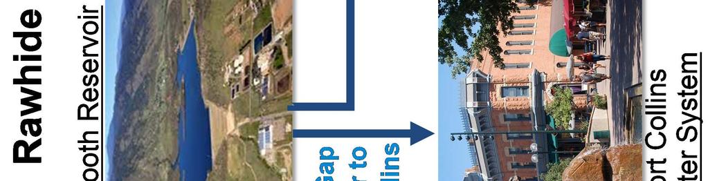
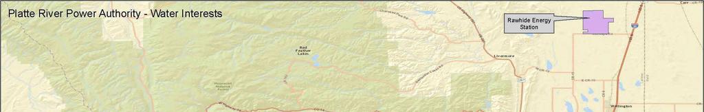
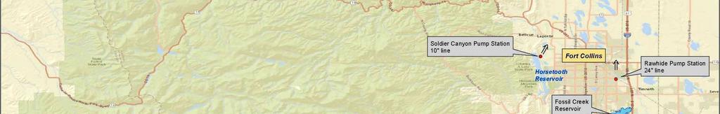
5 Platte River Water Resources Reference Document Section I. Background and History 1. Why Platte River Needs Water: The Rawhide Energy Station (Rawhide) includes Rawhide Unit 1, a coal-fired unit which uses steam to generate power. The process of this electric generation requires a supply of water for various purposes. First, the steam must be cooled to a liquid after exiting the turbine. The condenser uses cooling water from the Hamilton Reservoir at Rawhide for this purpose. The reservoir is 500 surface acres, has a capacity of 16,000 acre-feet 1, and loses an average of three million gallons of water per day (approximately nine acrefeet/day) to evaporation into the atmosphere. Based on pumping data over the past ten years, an average of 3,525 acre-feet of water is needed annually to maintain the reservoir level; however, the amount of water pumped can range from 2,500 to 4,500 acre-feet of water annually. The pumping needs to replenish the water can vary depending on many conditions including the evaporation rate (affected by air temperature, wind conditions, humidity, reservoir temperature, etc.), precipitation, and plant performance. The evaporation rate of a cooling reservoir is slightly higher than the natural evaporation rate in a regular lake or reservoir due to the increased temperature of a cooling reservoir. The annual average temperature of Hamilton Reservoir is 70 degrees. In addition, the generally windy conditions at Rawhide also contribute to the increased evaporation rate of Hamilton Reservoir. The water stored in Hamilton Reservoir is treated reusable effluent pumped from the City of Fort Collins Drake Water Reclamation Facility via a 24-inch pipeline to Rawhide. When Platte River Power Authority was first contemplating resource plans in the 1970 s, the Rawhide Energy Project Environmental Impact Analysis (EIA) was completed in 1978, and contemplated various types of cooling systems, including a cooling pond, wet cooling towers, wet/dry cooling towers and dry cooling. Based on the water requirements and the total cost for each option at a designed total capacity of 750MW (three coal units), the decision was made to cool Rawhide Unit 1 with the cooling pond (now referred to as a cooling reservoir). In addition to the water used for cooling, water is needed for purposes to which treated reusable effluent is unsuitable (boiler water makeup, site service water, fire water and drinking water). This water is called process water and is pumped to Rawhide in a separate 10-inch pipeline directly from Horsetooth Reservoir in an amount of approximately 500 to 600 acre-feet per year. In the past, this amount had varied up to 950 acre-feet per year, but conservation efforts and equipment upgrades over the past several years have reduced the amount of process water needed at Rawhide. Water conservation is a key element of plant operations. All of the water that is used onsite is recycled as much as possible and used in other plant processes. The entire Rawhide site is a zero discharge facility - the effluent and other plant water is used to extinction. The water that can be used at Rawhide needs to be fully consumable and reusable water, which is a very specific type of water under Colorado water law. 1 An acre-foot is 325,851 gallons, or the volume of water that would cover one acre of land to a depth of one foot. 1
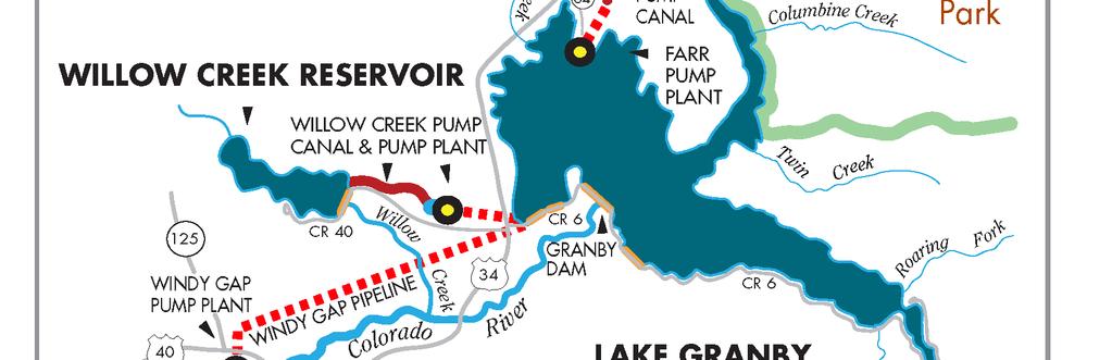
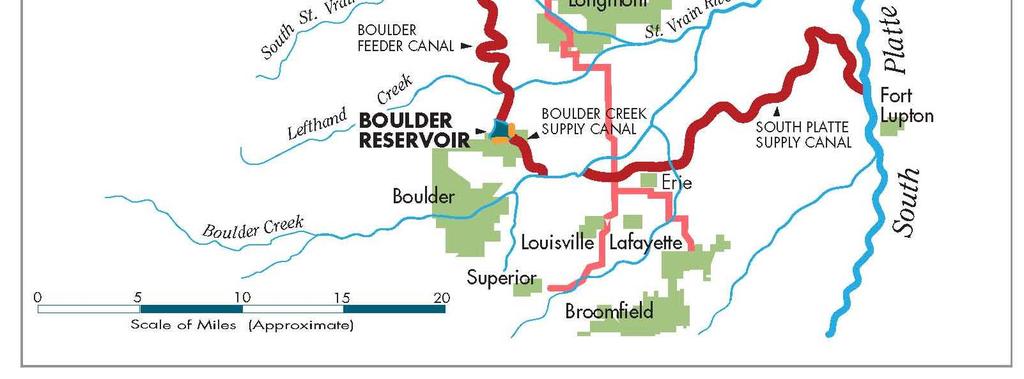
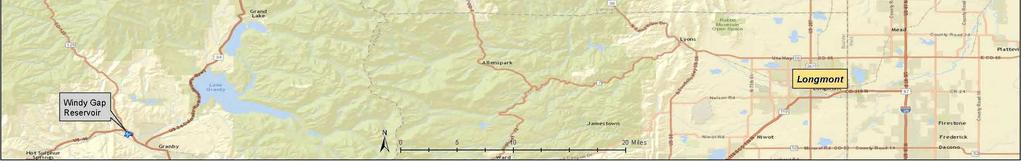
6 2. Water Supply Sources: Windy Gap Project Platte River is a participant in the Windy Gap Project, which delivers water from the west slope of Colorado to the Front Range. Platte River originally owned a contract allocation of 160 units of the Windy Gap Project (out of a total of 480 units) and currently owns 137 units. A unit is equivalent to 100 acre-feet during years of full Windy Gap Project production. Platte River acquired its original allocation of Windy Gap water from three of its constituent Municipalities in These allocations included 40 units from the Town of Estes Park, 80 units from the City of Fort Collins and 40 units from the City of Loveland. The Windy Gap Project was first contemplated in 1967 when the water rights on the Colorado River were filed. Following completion and approval of an Environmental Impact Statement and acquisition of 23 permits and licenses, the Windy Gap Project construction began in July The project was completed in 1985 and began delivering water to allottees in July. The Windy Gap Project consists of a diversion dam on the Colorado River, a 445 acre-foot reservoir, a pumping plant, and a six-mile pipeline to Lake Granby. Windy Gap water is pumped to Lake Granby during high flow months (typically April-July). The water is stored in Lake Granby until needed and is subsequently delivered across the Continental Divide through the Adams Tunnel under a carriage contract with the United States Bureau of Reclamation (Reclamation) for delivery through the Colorado-Big Thompson (C-BT) Project s facilities, including Carter Lake and Horsetooth Reservoir. Northern Colorado Water Conservancy District (Northern Water) and Reclamation jointly operate and maintain the C-BT Project (maps shown in Appendix A). Northern Water s Municipal Subdistrict (Municipal Subdistrict) is a separate conservancy district, which was formed by several municipalities to build and operate the Windy Gap Project. The Windy Gap Project participants are listed below, with a project map following. Windy Gap Project Participants Units Acre Feet (Max) Percentage Platte River Power Authority , % City of Longmont 80 8, % City & County of Broomfield 56 5, % City of Greeley 52 5, % City of Loveland 40 4, % City of Boulder 37 3, % Town of Erie 20 2, % Little Thompson Water District 17 1, % Superior Metropolitan District No , % City of Fort Lupton 13 1, % City of Louisville % Town of Estes Park % City of Lafayette % Central Weld County Water District % Total , % 2


7 3 Northern Colorado Water Conservancy District
8 Platte River s 137 units can produce up to 13,700 acre-feet of Windy Gap water annually, during years of full project production. However, the actual yield is generally far less than that and can range anywhere from zero acre-feet per unit up to 100 acre-feet per unit. Windy Gap water is provided as a contract allotment from the Municipal Subdistrict. This means Platte River does not own Windy Gap water rights but has a contractual right to require the Municipal Subdistrict to deliver Windy Gap water to the extent it is available. A benefit to Municipal Subdistrict allottees is that allotment contract holders are granted total consumptive use of their Windy Gap water. Allottees can use and reuse Windy Gap water because it is imported water not native to the South Platte Basin. After first use within Subdistrict boundaries, participants may use, lease, transfer or sell the reuse or successive use rights for use within or outside Subdistrict boundaries. This type of fully consumable water is needed at Rawhide due to the nature of it being a zero discharge facility. Typically, Platte River places an annual Windy Gap order of 5,100 acre-feet, of which 4,200 acre-feet is provided to the City of Fort Collins in exchange for reusable effluent, which is pumped to Rawhide for cooling purposes. The remaining 900 acre-feet meets Rawhide s process water needs, augmentation needs, and Windy Gap Project shrink. Cache La Poudre River Decrees In addition, Platte River holds two junior water rights on the Cache La Poudre River which, when in priority, allow Platte River to pump Poudre River water credits to Rawhide in its 24-inch pipeline (via exchange). Below are the specifics of the rights. Flow Rate (cubic feet per Flow Rate Conversion Date of Adjudication second, cfs) 2 to acre-feet (AF)/day 1.60 cfs ~ 3.17 AF/day December 31, cfs ~ AF/day December 1, 1977 Because these rights are junior (recent) in priority, the water is not available every year and cannot be counted on as a firm, reliable supply. During the past ten years, the Poudre River decrees have yielded anywhere between 0 and 2,800 acre-feet of water per year, or an average of 966 acre-feet per year. 3. Water Agreements and Decrees: In addition to the contract allotments to Windy Gap water, Platte River is party to other agreements and decrees that are instrumental to the exchange, receipt and storage of the water used for cooling. There are four key agreements that are fundamental to Platte River s water operations. Reuse Agreement When construction of Rawhide was first being contemplated, it was known that the generation station would require water for cooling and other purposes. Platte River recognized the fact that the Front Range of Colorado is an arid region, and so from day one, the objective was to use water in a responsible and sustainable way. In 1978, an 2 One cfs equals 1.98 acre-feet/day. 4
9 innovative agreement was developed, in which fully consumable and reusable water is first used by the City of Fort Collins, and the return flows (reusable effluent) are pumped to Hamilton Reservoir at the plant and used for cooling purposes. The purpose of this arrangement is so that Rawhide s use of the water would have no detrimental effect upon any existing water user, or upon existing water supplies. The use of this effluent was incorporated into the original plant design. The Agreement for the Reuse of Water for Energy Generation (Reuse Agreement) is a three-way agreement between the City of Fort Collins (Fort Collins), Water Supply and Storage Company (WSSC) and Platte River. The agreement and associated Decree (W ) is based on a series of exchanges that use new foreign water 3 supplied by Fort Collins and WSSC to produce 4,200 acre-feet of reusable effluent for Platte River s use each year. Under this arrangement, WSSC commits an estimated 4,581 acre-feet of its new foreign water and Fort Collins commits an estimated 3,055 acre-feet of its new foreign water to create a supply of new foreign water of up to 7,636 acre-feet annually for the plan. The new foreign water is used by Fort Collins to generate reusable effluent return flows of 4,200 acre-feet that are provided to Platte River. To compensate Fort Collins and WSSC for this reusable effluent, Platte River transfers a total of 4,200 acre-feet of Windy Gap water annually to Fort Collins, and in turn Fort Collins transfers 1,890 acre-feet of C-BT water from the Fort Collins C-BT account to WSSC. Included in WSSC s compensation is a 25 percent processing charge assessed on WSSC by Fort Collins for processing the water contributed by WSSC. In addition, there is an obligation to preserve the historic regimen of the Poudre River by assuring a continuation of water flows equal to historic return flows. As described in Decree W , one method to meet this obligation is to release 550 acre-feet annually to the Poudre River. This obligation is split between Fort Collins (467 acre-feet) and Platte River (83 acre-feet). In addition to the 4,200 acre-feet of effluent provided from the Reuse Agreement, Platte River is also entitled to the return flows from the Windy Gap water supplied to Fort Collins. The estimated return flows from the use of the Windy Gap water are approximately 2,310 acre-feet, or an average of 55 percent. Consequently, the water available to Platte River under the Reuse Agreement (prior to the MOU as described below) includes 4,200 acre-feet of reusable effluent plus approximately 2,310 acre-feet of Windy Gap return flows, for a total of 6,510 acre-feet. Memorandum of Understanding When Anheuser-Busch, Inc. (now Anheuser-Busch InBev or AB InBev) located to Fort Collins, it needed approximately 4,200 acre-feet of fully consumable water annually coincidentally the same amount of water provided in the Reuse Agreement. Platte River and Fort Collins entered into a Memorandum of Understanding (MOU) with AB InBev in The MOU allows Fort Collins to designate up to 4,200 acre-feet of the Windy Gap water owed to Fort Collins under the Reuse Agreement for use by the AB InBev brewery. AB InBev employs a land application to process brewery waste and therefore does not send as much wastewater to Fort Collins Drake Water Reclamation Facility as would an average Fort Collins customer. This means that when the Windy Gap water is designated to support AB InBev s treated water use, less effluent is produced for Platte River. Under 3 New Foreign Water is water introduced into the Cache La Poudre Basin from the Colorado and Michigan River Basins and whose return flows historically have not been used by others, as defined in the agreement. 5
10 the MOU, Platte River agrees to accept less Windy Gap return flows (approximately 800 acre-feet instead of the approximately 2,310 acre-feet of effluent expected under the Reuse Agreement). In return, AB InBev pays Platte River s annual variable operating costs on 4,200 acre-feet of Windy Gap water and accepts certain responsibilities in the event that Windy Gap water is in short supply. AB InBev also has the option of providing a substitute supply of reusable water instead of Windy Gap effluent. When AB InBev uses all of the 4,200 acre-feet of Windy Gap water, the net result is that Platte River receives reusable water available under the Reuse Agreement and MOU in an amount of approximately 4,200 acre-feet plus 800 acre-feet of return flows from AB InBev annually. When AB InBev does not use the full 4,200 acre-feet of Windy Gap water, AB InBev can proportionally reduce their 800 acre-foot return flow obligation. The remaining Windy Gap water not used by AB InBev is used by other Fort Collins customers and Platte River receives the generated return flows. Independent of the amount of Windy Gap actually used by AB InBev under normal reuse operations, AB InBev is still responsible for paying the operating costs on the full 4,200 acre-feet of Windy Gap water. In most years, the total amount of reusable effluent available to Platte River is approximately 5,431 acre-feet per year as shown in the table below. This is sufficient to meet all of Platte River s cooling water needs for Rawhide at this time with some reserve water available for future generation or other uses. Average Annual Reusable Effluent Water Available To Platte River Reusable Effluent Water Sources Reuse Agreement Exchange MOU: Windy Gap return flows Annual Quantity (AF) Comments 4,200 Contractual quantity 1,231 Estimate Total reusable effluent water available 5,431 Estimate North Poudre Storage Agreement Platte River has an agreement with the North Poudre Irrigation Company (North Poudre) that allows Platte River to utilize North Poudre s Fossil Creek Reservoir Inlet Ditch and temporarily store the reusable effluent in Fossil Creek Reservoir. This agreement, which expires in 2024, makes use of exchanges and is necessary to avoid loss of the treated effluent if it cannot be pumped to Rawhide at the same rate the effluent is delivered by Fort Collins at the Drake Water Reclamation Facility. This agreement allows Platte River to store and withdraw treated effluent from Fossil Creek Reservoir. Upon expiration of this agreement, Platte River would no longer be able to store and withdraw treated effluent from Fossil Creek Reservoir (without a contract extension) but would maintain the perpetual right to use the Fossil Creek Inlet Ditch. The water held by Platte River in Fossil Creek Reservoir is subject to loss when the reservoir spills, which typically happens on an annual basis. To avoid uncompensated loss of this water, the board authorized the lease of unpumped reusable effluent beginning 6
11 in When Platte River leases water out of Fossil Creek Reservoir, a percentage of the proceeds are shared with North Poudre. Soldier Canyon Outlet Agreement Platte River has an agreement with Fort Collins for a portion of the capacity of the Soldier Canyon Outlet from Horsetooth Reservoir. This agreement was entered into in 1981 for three cfs of capacity for the purpose of pumping process water from Horsetooth Reservoir to Rawhide via the 10-inch pipeline. The agreement allows Platte River to connect to and operate a tap from the existing Fort Collins raw water delivery system at a point on the system below where the system connects to the Soldier Canyon Outlet from Horsetooth Reservoir. From that point, the water is pumped via Platte River s 10-inch pipeline from the tap to Rawhide. Other Water Related Agreements: There are two additional water agreements currently of significance to Platte River. Larimer County Agreement Strang Gravel Pit Augmentation The Larimer County agreement was entered into in 1993 and allows the County to receive up to 100 acre-feet annually of reusable effluent provided by Platte River (under the MOU) for augmentation of the County s Strang Gravel Pit. The County notifies Platte River each year of the actual quantity of water needed for the augmentation requirement. While the request from the County in the agreement is for 100 acre-feet, the actual augmentation needs have typically been less than 12 acre-feet per year. Carter Lake Outlet Agreement The Carter Lake Outlet Agreement is part of the Southern Water Supply Project and is an allotment contract executed in 1994 that provides Platte River with a delivery capacity of up to ten cfs 4 from the Carter Lake outlet. In 2001, there was an additional allotment contract of eight cfs of capacity, bringing the total capacity allotment to 18 cfs 5. Based on the potential water needs associated with a future generation resource on the southern end of the Platte River system, it has been determined that a portion of the capacity could be sold to other project participants. As a result, Platte River is currently in negotiations to sell 13 cfs of outlet capacity, thus retaining five cfs 6 of capacity. This capacity is not in use at this time but could be of value for either delivering water to a future generation resource on the southern end of Platte River s system, or for leased Windy Gap water to be delivered out of Carter Lake in the future. Water Decrees There are also a number of water rights and decrees that are instrumental in the exchange, delivery and storage of water for Platte River. There are two key decrees to point out. The Reuse Decree authorizes the exchanges necessary for the Reuse Agreement and the Hamilton Reservoir Storage Decree allows the storage and operation of the 16,000 acrefoot cooling reservoir at the Rawhide Energy Station. The 24-inch pipeline that supplies water to Hamilton Reservoir has several associated exchange decrees to provide flexibility 4 The capacity of ten cfs would equate to 19.8 acre-feet/day. 5 The capacity of 18 cfs would equate to 35.7 acre-feet/day. 6 The capacity of five cfs would equate to 9.9 acre-feet/day. 7
12 in pumping water through the pipeline. A complete list of agreements, rights and decrees is shown in Appendix B Current Annual Water Use: Cooling Water: Platte River currently uses an annual average of approximately 3,525 acrefeet of reusable effluent for cooling purposes; however, cooling water use at Rawhide can vary from 2,500 to 4,500 acre-feet annually depending on weather and operating conditions. Once the effluent is pumped to Rawhide, it is further treated in a phosphorus removal facility at the plant prior to entering the cooling reservoir. Augmentation Water: Approximately 221 acre-feet of additional reusable effluent is provided annually to Fort Collins and the Cache La Poudre River in order to meet augmentation requirements related to the Reuse Agreement, the Rawhide Energy Station property (Rawhide Creek), Platte River s headquarters property (headquarters well), and the Larimer County Augmentation Agreement. Process Water: Platte River also pumps an average of 498 acre-feet of Windy Gap water directly from Horsetooth Reservoir to Rawhide via the 10-inch pipeline from the Soldier Canyon Outlet. This water is used for process water at the plant (boiler water, site service water, fire water and drinking water). The treatment system for this water is considered a Non-Transient, Non-Community Public Water Supply and is regulated by Colorado Department of Public Health and Environment (CDPHE) under PWSID CO It is operated by certified Class A and B water treatment and Class 1 distribution system operators. Platte River Water Use Rawhide cooling water: 24-inch pipeline Augmentation requirements Reuse Agreement (83AF) Rawhide Creek (100AF) HQ Well (26AF) Larimer County Agreement (~12AF) Rawhide process water: 10-inch pipeline Platte River s Water Use Avg. Annual Quantity (AF) 3, Type of Water Reusable Effluent Reusable Effluent Windy Gap Comments Estimate based on a 10- year average includes some 10 line water that went to reservoir Can vary up to 309 AF. The quantity of 221 AF is based on the 10-year average amount needed for the Larimer County Agreement. 10-year average is 498 AF (process water only) not including any water that went to the reservoir Total Use 4,244 Annual average A diagram showing the general arrangement for Rawhide water supply and use follows. 8


13 9
14 5. Water Costs Capital and Operating: The following table is a summary of Platte River s annual average water costs. These figures do not include pumping costs through the 24-inch and 10-inch pipelines to Rawhide, or the costs to treat water at Rawhide. The amounts shown are Platte River s typical costs excluding the amounts allocated and charged to AB InBev. Platte River Net Water Costs Capital Costs Windy Gap Project Debt Service Operating Costs * Windy Gap Pumping Cost Windy Gap Carriage Costs Windy Gap Assessment Costs (Operations and Maintenance Expenses) Windy Gap Fixed Costs Total Operating Costs Estimated Annual Amount $0 $21,000 $54,000 $342,000 Comments The annual debt service payment was approximately $3,300,000, but the bonds were defeased in There will be capital costs for the Windy Gap Firming Project, but those bonds have not been issued yet. Pumping of up to 600 AF annually if Windy Gap Project pumps (approx. $35/AF). Carriage costs for use of C-BT system to convey up to 600 AF of Windy Gap water annually (approx. $90/AF) to Horsetooth Reservoir. Annual assessment of 9,500 AF** of Platte River s 13,700 AF allocation. This price is currently set at $36/AF of Windy Gap water allocation whether it is pumped or not. $24,125 Annual Reclamation fixed costs $441,125 Approximate Total Costs $441,125 Approximate * Platte River s net costs are shown, excluding the charges covered by AB InBev through the MOU. ** Of Platte River s 13,700 acre-feet, Platte River pays the O&M expenses for 9,500 acre-feet, and AB InBev pays for 4,200 acre-feet. With respect to Windy Gap Project capital costs, the final debt payment made was in The final payment on the last Windy Gap Project bonds outstanding was originally scheduled to be made in December However, in March 2016 it was determined that there was enough money in project reserve funds to fund an Escrow Account to retire the principal and interest on the remaining debt when it came due. On April 14, 2016, the outstanding debt was defeased by Resolution of the Municipal Subdistrict board. Funding of the Escrow Account was at the end of April At that time the Windy Gap Project Bonds were considered to be discharged and the Windy Gap Project free of debt. Starting in 2017, only the operating costs are required. 10
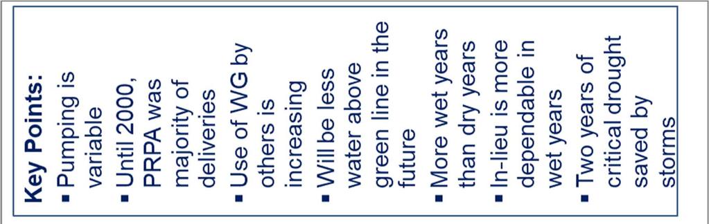
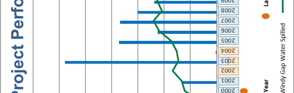
15 Section II. Current Activity Windy Gap Firming Project 1. The Critical Nature of Water Supply to Generation Operations and Windy Gap Project Performance: Platte River requires a minimum of 4,200 acre-feet of Windy Gap water per year in order to complete the water exchange activities contemplated under the Reuse Agreement and MOU. Absent Windy Gap water to exchange, Platte River receives a significantly reduced amount of reusable treated effluent from the Reuse Agreement and MOU. There is also a need for approximately 500 to 600 acre-feet of Windy Gap water each year for direct pumping to Rawhide for service and process water. Both of these sources of water are critical to the reliable operation of Rawhide. An additional complication is that both the cooling water and the process water need to be fully consumable and reusable water. Historically, Platte River s annual Windy Gap order has been approximately 5,100 acrefeet based on the following breakdown. Platte River s Water Requirements/Contractual Obligations: Windy Gap Project Order Components Average Annual Quantity (AF) Reuse Plan, contractual requirement 4,200 Process Water, 10 line pumped to Rawhide 600 Windy Gap Project Shrink (a 10% shrink factor is applied to Windy Gap balances in Lake Granby on March 31) 300 Total Average Annual Order 5,100 Because Windy Gap water is the only significant water source held by Platte River, it is essential that this water be available every year. Although Platte River has always depended heavily on Windy Gap deliveries, during the early years of operation the volumes delivered to the other project participants were relatively small. Platte River s annual Windy Gap water order of approximately 5,100 acre-feet was the largest order for many of those early years. As the Windy Gap Project began to be more fully utilized, delivery issues emerged. These issues arise not only from the junior nature of the Windy Gap water rights, but also from limitations inherent in the C-BT Project through which Windy Gap water is stored and delivered. There are two primary reasons that Windy Gap Project participants have not been able to rely on Windy Gap water deliveries. In dry years the Windy Gap water decrees are not in priority, and thus the Windy Gap Project will not pump. Because of the project s junior water rights, Windy Gap water cannot be diverted in years of low runoff. Counterintuitively, the Windy Gap Project also presents issues during wet years. There have been several years when the Windy Gap Project could have pumped but didn t because there was no place to store the pumped water. Currently, Lake Granby is the only storage available for Windy Gap Project water. Water conveyed and stored for the C-BT Project has priority over water conveyed and stored for the Windy Gap Project. Thus, in 11
16 wet years, when the C-BT system is full, there is no conveyance or storage capacity for Windy Gap Project water. This prevents the Windy Gap Project from storing water in wet years for use in subsequent dry years. This situation of the lack of storage space during wet periods has occurred numerous times over the years, and as recent as 2015, 2016, and In addition, if Lake Granby spills due to wet year inflows and there is Windy Gap Project water in storage, it is the first to spill. This happened several times in the late 1990s, in 2011, and most recently in 2014 when approximately 11,500 acre-feet of stored Windy Gap water spilled because the C-BT system filled and overflowed. Because the Windy Gap Project is unable to provide reliable yields in both wet and dry years, the current firm yield is zero. Firm yield is typically defined as the amount of water that can be delivered on a reliable basis in all years and is typically determined by yield in dry years. Specific to the Windy Gap Project, lack of available storage space in wet years also affects firm yield. To address the issue of sporadic deliveries, a protocol entitled Criteria for Integrated Operations of the Colorado-Big Thompson and Windy Gap Projects (Integrated Operations), was developed in Through Integrated Operations, C-BT Project water may be delivered to Windy Gap Participants in-lieu of Windy Gap water. Replacement of C-BT Project water attributable to such in-lieu deliveries is required from Windy Gap water pumped in subsequent periods. Windy Gap Project Participants who request inlieu deliveries may be required to incur additional expenses or make other water available, if needed, to assure that C-BT Project beneficiaries are not injured as the result of such in-lieu deliveries. In extremely dry years even Integrated Operations may not allow the use of in-lieu Windy Gap water. This occurred in when the C-BT system did not have sufficient unallocated reserve water in storage to support the in-lieu program. During that period Platte River had to look elsewhere for water and obtained a lease for reusable water from a Front Range municipality. This water was used for the critical process water needs and enabled Rawhide Unit 1 to continue operations. Fortunately, a large snowfall in March 2003 provided enough water to enable the Windy Gap Project to pump and Windy Gap water became available. Had this snow event not occurred, it is uncertain how water would have been obtained for Rawhide operations. The water year was similar to the extreme dry year of with no Windy Gap water available in the C-BT system; however, Platte River was able to obtain water utilizing the in-lieu process. Leased C-BT water was used as collateral to provide Windy Gap water for the critical process water. Had the reserves in the C-BT system been depleted, or if C-BT water was not available on the rental market, Integrated Operations would not have been an option. In and again in , Platte River and the City of Fort Collins were able to work out a special arrangement during these Windy Gap short periods to provide water for the MOU and cooling water, which was very beneficial to Platte River. The drought period would have been much more costly to Platte River had this agreement not been in place and had the Windy Gap Project not pumped in the late spring of This enabled Platte River to revert back to normal operations halfway through the year. Acquiring reusable water through the rental market can be uncertain, unreliable and at times very expensive. 12
17 Although rental water is easier to acquire in wet years, the availability and pricing is subject to market volatility. Rental water is first sought from the owner Municipalities; however, if water is not available from the Municipalities, then Platte River will reach out to others for leasing C-BT water. Recently, Platte River has secured long-term C-BT lease agreements as well as rights of first refusal to lease C-BT water when available from other municipalities. These resources provide additional security and are typically sufficient to supply the process water needs at Rawhide. The following table lists the amount of C-BT water that was used in-lieu of Windy Gap water from 2012 through the 2017 water year. Water Year Water Leased from Others Total C-BT Collateral Water Provided (AF) , * 1, , , * 2, * 2,114 *Water short years which also included a special arrangement with Fort Collins for the Reuse Agreement. Over the years, the Windy Gap water supply has proven to be less reliable than initially anticipated. Weather conditions such as severe drought or extreme snowpack limit Windy Gap water availability. There have been numerous occasions, even as recent as the 2015, 2016 and 2017 water years, when Platte River was operating in a water short situation (special arrangement with Fort Collins), which severely limits the ability to produce the water necessary for Rawhide operations. Although Rawhide has never been curtailed due to a lack of water supply, continued dependence on weather events to secure Platte River s water supply is not a reliable long-term strategy. In the original Windy Gap Project Environmental Impact Statement (EIS), the Windy Gap Project was estimated to yield 48,000 acre-feet per year. Because each unit of Windy Gap water is entitled to 1/480 th of the annual yield of the project, a unit was expected to produce a yield of up to 100 acre-feet per year. The actual Windy Gap yield between 1985 and 2015 averaged approximately 12,000 acre-feet per year (vs. 48,000 acre-feet per year), which is an average annual yield to the Project Participants of about 25 acre-feet per year for each unit, or 25% of the projected yield of 100 acre-feet per year. However, this actual average yield is somewhat limited due to demand of the participants being less than available supply in some years. Because of this, and as stated in the EIS for the Windy Gap Firming Project, a study was conducted to see what the average yield of the Windy Gap Project would have been if Windy Gap unit holders used all available Windy Gap water. In this scenario it was calculated that the average long-term yield (using hydrology from 1950 to 1996) would have been about 55 to 60 acre-feet per unit. But it is important to note as stated above, the firm yield of the project is still considered to be zero. The chart on the following page shows the historical Windy Gap Project performance and the associated impacts of both wet and dry years as discussed above. 13
18
19 2. History and Status of Windy Gap Firming: The Windy Gap Project was completed in 1985, and as noted above, deliverability issues led to the adoption of the Integrated Operations protocols six years later. Participants recognized that Integrated Operations could provide relief under certain conditions but would be ineffective during periods of extreme weather. Discussions of a firming project began during the mid-1990s. At that time Platte River commissioned a study of water supply alternatives. This study was completed in 1999 and confirmed that participation in the Windy Gap Firming Project (Firming Project) was the most effective means to further secure Platte River s water supply. The Firming Project is simply a new reservoir (Chimney Hollow Reservoir) into which Windy Gap water would be pumped in wet years and stored for use in dry years when the Windy Gap Project does not pump. Such a storage arrangement would significantly improve operational reliability and reduce water cost volatility. Due to the critical nature of a water supply for Rawhide, a firm yield of water is essential for reliable electric generation operations. A firm yield is defined as the maximum quantity of water that can be guaranteed with some specified degree of confidence during a specific critical period. In July 2000, Platte River signed an interim agreement with Northern Water and the Municipal Subdistrict to continue its participation in studies of the Firming Project. Project Milestones: 2003: A total of 13 Windy Gap water participants began the federal permitting process for the Firming Project in A report was produced that compared 170 potential firming options. 2005: Reclamation, the lead agency for the project, published the Purpose, Need and Alternatives report in As part of the National Environmental Policy Act (NEPA) process, the Municipal Subdistrict engaged in a collaborative negotiation with west slope entities to develop mitigation and enhancement measures that would offset the environmental impacts of the Firming Project. 2008: A draft Environmental Impact Statement (EIS) was issued by Reclamation in This report outlined the purpose and need of the project, environmental impacts and proposed mitigation measures. 2009: The Municipal Subdistrict offered benefits to the west slope to facilitate project implementation. 2011: The mitigation and added enhancement measures were reviewed by the Colorado Wildlife Commission and Colorado Water Conservation Board and were unanimously accepted in the summer of Following this, in November 2011, Reclamation published the Final EIS. 2012: A 1041 permit was filed with Grand County. Grand County (west slope) and the Municipal Subdistrict board approved agreements to create improvements to the Colorado River. This 1041 permit was approved by Grand County on November 20, The Northern Water board and Municipal Subdistrict board accepted the permit in principal on November 26, This permit includes an Intergovernmental Agreement (IGA) that ensures enhancements agreed to during the EIS process will be implemented. 15
20 2014: Reclamation issued its Record of Decision (ROD) and signed a carriage contract to transport water to Chimney Hollow Reservoir. Negotiations on the carriage contract, which is an agreement that outlines the terms and conditions for Windy Gap water to be transported through the C-BT system and stored in Chimney Hollow Reservoir, began in late On December 19, 2014, officials from Northern Water, Northern Water s Municipal Subdistrict and Reclamation signed a new carriage contract and the ROD. The ROD identifies and confirms Chimney Hollow Reservoir as the Firming Project s preferred alternative. The new carriage contract will apply to all Windy Gap water, including the proposed Firming Project water, and the term of the contract has been extended to 2054 (it was previously set to expire in 2025). This adds a level of certainty to the entire project for years to come. The ROD was the final approval needed for the NEPA process. The signing of the ROD and the new carriage contract were major milestones for the Firming Project. 2016: The Municipal Subdistrict submitted the application for the 401 water quality certification to the State Water Quality Control Division in late 2015, and the final 401 Certification (certification that the project will comply with applicable water quality standards) was awarded on March 28, : The US Army Corps of Engineers approved a Section 404 (wetlands mitigation) permit for the project in May This was the last major federal permit required for construction. In October 2017, a lawsuit was filed in US District Court that challenges the adequacy of the environmental reviews and approvals issued by the Bureau of Reclamation and the Army Corps of Engineers. While not named in the original lawsuit as a respondent, the Municipal Subdistrict did intervene in the case to be directly involved. The Municipal Subdistrict and the Firming Project participants will monitor the case closely. It is uncertain at this time whether it will impact the project schedule. To incorporate the Windy Gap Firming Project into the operations of the Windy Gap system, the original water right decree for the Windy Gap project required amendment. As part of the process to amend the water right, objectors are given the opportunity to raise any issues or concerns they may have with the project from a water rights perspective. The IGA that the Municipal Subdistrict and several West Slope parties agreed to as part of the 1041 permit process will help ensure that there will be fewer objectors to the application. Within the IGA, the parties agreed to incorporate several mitigation and enhancement projects into the overall Windy Gap Firming Project. In exchange, the west slope entities agreed to support the proposed project and the amendment to the water right. The water rights amendment was filed in September 2017 after incorporating input from the West Slope parties. The water rights amendment process is expected to be complete sometime in late PFM Financial (PFM) has been contracted by the Municipal Subdistrict to provide Municipal Advisor (MA) services and investigate the various financing options available for the project. In addition to acting as MA for the overall project, PFM also provides MA services to individual project participants including Platte River, although these services are provided through a different office than those for the overall project MA team. The 16
21 primary options that PFM is investigating include individual and group financing. Platte River is considering both options; however, the final decision will be contingent on a determination by the IRS regarding Platte River s tax-exempt status for financing the project. Due to its arrangement with AB-Inbev under the MOU (see Section I.3), Platte River sought clarification prior to any decision regarding joining the tax-exempt group financing package. By February of 2018, Stantec, the Windy Gap Firming Project design engineer had reached the pre-final design stage, which included the development of a detailed project cost estimate (-20% to +30% accuracy) and the development of a design document package that was substantially complete and ready for the final review process. 3. Next Steps for the Firming Project: The final phase of the project design is a series of design reviews and updates. The first review, anticipated in mid-april 2018, is a review by the project review board, which consists of a panel of independent dam design and construction experts. Following that review, Stantec will make and necessary design revisions and submit the final design package to the Colorado Division of Water Resources Dam Safety section for a final review after which the design will be updated accordingly and considered complete. This final design review is anticipated in the summer of Upon completion of the design, the project focus will turn to the construction phase. A contractor bid process will be completed to select the most qualified contractor team. Once the final construction costs are determined from the successful bid, the Windy Gap participants will be able to secure individual and group financing for the project. All construction activities will be contingent on the resolution of the lawsuit. 4. Firming Project Schedule: The water rights amendment and lawsuit are two remaining legal issues that have unclear completion timetables. Without significant objections, the water rights amendment is anticipated to be complete by the end of It is also possible that the lawsuit may also be settled by the end of However, until the lawsuit is resolved, financing and project construction will be delayed. Once construction activities commence, the project will be complete and ready to begin filling within three to four years. 5. Determination of Firming Storage Requirements: The Municipal Subdistrict conducted studies in conjunction with Boyle Engineering based on each participant s Windy Gap Project allocation, projected Windy Gap water use and the historical hydrology of the C-BT system and Windy Gap Project supply over the past 46 years. In addition, Platte River contracted Heather Thompson, P.E., Senior Water Resource Engineer with Ecological Resource Consultants, Inc., to determine Platte River s specific firming level. This study revealed that 13,000 acre-feet of firming storage would provide the necessary ratio of storage to demand to enable Platte River to obtain the annual requirement of Windy Gap water in a reliable manner for a typical year. After further internal evaluation, Platte River staff recommended a reduction in Firming Project participation. On April 16, 2008, Platte River staff recommended to the Board of Directors that the Firming Project storage level be reduced to 12,000 acre-feet. This level of firming was thought to provide a balanced approach to meeting operational needs and still 17
22 positioning Platte River to fulfill contractual obligations at reduced costs based on historical hydrology. The Board of Directors accepted this recommendation and Platte River s share of the firming storage level was reduced to a participation level of 12,000 acre-feet (which would provide a firm supply of approximately one third that amount). In August 2014, Heather Thompson was contracted to conduct some additional modeling analysis to evaluate various levels of demand and Windy Gap storage for Platte River. Four different levels of storage were evaluated, ranging from 13,000 acre-feet up to 16,000 acre-feet (the data for 12,000 had previously been modeled). For each level of storage, four levels of Windy Gap ownership were evaluated including 100, 120, 140 and 160 units. Additionally, a separate analysis was conducted outside of the Windy Gap Firming Project Model to determine the demand that could be met under a synthetic two-year and three-year drought assuming that no Windy Gap is pumped for two and three years in a row, respectively. Probability plotting was used to estimate the frequency of these synthetic droughts. The highlights of the model analysis are shown below. The summary is based on ownership level ranging from 100 units to 160 units and shows the amount of water that would be firmed in different scenarios. In addition, the frequency of the drought interval is listed for both the two-year and three-year scenarios without any Windy Gap pumping. The numbers provided on those categories show how much water would be firm each year for the two or three year duration. For example, at a storage level of 12,000 acre-feet, if the project experienced three years with no pumping, the amount of water that would be considered firmed, would be 3,050 acre-feet in years one through three. If more water were used in the first year, then there would be less water available in future years. Based on the results below, at any storage level, Platte River could tolerate a 1-in-50 year drought event, and could manage with modified water operations in either a 1-in-57 year drought event (two consecutive years of no Windy Gap pumping), or a 1- in-250 year drought event (three consecutive years of no Windy Gap pumping). A modified water operation may include either pumping less effluent to Hamilton Reservoir (using more of the effluent stored in Hamilton, thus allowing the level to drop), or leasing additional effluent. Both cases would require a special arrangement/reduction in the Reuse Agreement. The complete model analysis summary memo and entire table (which shows all the scenarios of firmed water at various storage levels and various ownership units) is provided in Appendix B-3. 18
23 Firming Project Storage (AF) Windy Gap Firming Project Model Analysis (based on units)* Annual Firmed Windy Gap (AF) ** Historic Hydrology: 1 in 50 years Annual Firmed Windy Gap (AF) with two years of no pumping Occurrence Interval: 1 in 57 years Annual Firmed Windy Gap (AF) with three years of no pumping Occurrence Interval: 1 in 250 years 12,000 4,545-4,730 4,265 3,050 13,000 4,890-5,085 4,625 3,310 14,000 5,235-5,430 4,980 3,560 15,000 5,490-5,815 5,340 3,820 16,000 5,730-6,195 5,695 4,075 * All scenarios include a 5% Reintroduction Shrink, which is defined as the reduction in Windy Gap water delivered from Chimney Hollow Reservoir (the intended firming reservoir) when this water is reintroduced back into the C-BT system from Chimney Hollow for delivery to Platte River via Horsetooth Reservoir. In both the scenarios of two years of no pumping and three years of no pumping, the yield is the same at an ownership level of 100 units up to 160 units. ** Historical hydrology shows a slightly different firm yield based on ownership level of Windy Gap units. Also, if temperature mitigation measures are required in a particular year, then the firm yield of this column would be reduced by approximately acrefeet/year. Based on the modeling data, and internal staff research, it became apparent that a participation level of 12,000 acre-feet would be insufficient to meet the current water resources needs/obligations of 5,100 acre-feet (listed in Section II.1). In July 2016, staff recommended an increase in Firming Project participation to a minimum level of 14,000 acre-feet and up to an optimal level of 16,000 acre-feet. The Board of Directors approved participation in the Firming Project up to 16,000 acre-feet. In 2017, Platte River s participation increased to 14,136 acre-feet, and in March 2018, Platte River reached a final participation level of 16,000 acre-feet. The Windy Gap water currently being held for future generation is not considered as part of the Firming Project at this time. Further evaluation on the pros and cons of firming the reserve water being held for future generation resources will need to be conducted. The need for firming will depend on the location and type of resource that is selected. In addition, other factors to consider when determining the firming level include the value of firmed water. Chimney Hollow Reservoir will change the total Windy Gap Project s reliable annual total yield from zero acre-feet of water to about 30,000 acre-feet, thus, improving the reliability of water deliveries to participating entities. There is a significant value to a firm and reliable water supply - whether it is for immediate needs or future needs. 19
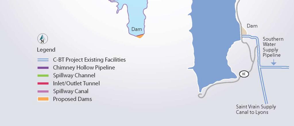
24 6. Firming Project Participants: Windy Gap Firming Project Participants WG Units Storage (AF) Percentage of Project City & County of Broomfield 56 26, % Platte River Power Authority , % City of Loveland 40 9, % City of Greeley 52 9, % City of Longmont 80 8, % Town of Erie 20 6, % Little Thompson Water District 17 4, % Superior Metropolitan District No , % City of Louisville 6 2, % City of Fort Lupton 13 1, % City of Lafayette % Central Weld County Water District % Total , % 7. Firming Project Costs: Early estimates of the Firming Project reservoir were based on size and not a specific location. In 2006, the first preliminary estimates were approximately $221 million for the reservoir. Once the EIS process had identified Chimney Hollow as the candidate firming reservoir location in 2011, the costs were further refined to $275 million for a reservoir size of 87,000 acre-feet. In 2017, the total project estimate was $407 million based on a conceptual engineer estimate, not including escalation or contingency. Currently, the total project cost estimate is $575 million based on the pre-final design and includes mitigation and enhancements, updated construction costs, estimated project escalation costs, and owner s cost estimates. With a total planned capacity now of 90,000 acre-feet of storage, this cost equates to approximately $6,388 per acre foot of storage space. The project cost will continue to fluctuate as the project design is finalized, construction bids are received, and legal issues are resolved. Of the current cost estimate, Platte River s current obligation for 16,000 acre-feet of storage is approximately $101 million, 17.8% of the total project cost. 8. Operation of the Firming Reservoir: Prior to construction of Chimney Hollow, a set of operating guidelines will be developed. At the present time, it is anticipated that Chimney Hollow will fill and discharge water via gravity flow; however, a pumping scenario that includes Flatiron Reservoir during filling is being considered as well. The operating guidelines will cover routine operation, scheduling water in and out of Chimney Hollow and evaporation/seepage loss calculation methodology. A general map of the proposed Chimney Reservoir appears on the next page, with a more detailed map shown in Appendix A-6. 20
25 Proposed Chimney Hollow Location Northern Colorado Water Conservancy District 21
26 Section III. Past Water Policy and Operations Prior to 2017, Platte River operated without a formal water policy in place. Instead, water management was guided by a series of board resolutions that laid out a general approach for securing water resources, future planning, and conducting water transactions. Board guidance was in the form of direction on topical issues, such as the adoption of resolutions regarding the lease of water or Windy Gap units and periodic approval of continued participation in the Firming Project. In general, three important principles were evident from board action. These principles included: (a) securing and protecting a water supply sufficient for Platte River current operational needs, (b) planning for Platte River s future water supply needs while contemplating the future needs of the Municipalities, and (c) leveraging value for water resources through leasing unpumped reusable effluent water and leasing Windy Gap units. 1. Background a. Securing and Protecting Water for Platte River operational needs. As described in Section II.1 of this document, Platte River has a water need/obligation of 5,100 acre-feet per year. This water supply adequately meets these operational needs when water and weather conditions are normal. In years with extreme wet or dry conditions, the water supply needs have been met through either the leverage achieved from the Windy Gap units (Platte River s pro-rata allocation is higher based on contract allotment ownership level), or alternative arrangements and sources. Participation in the Windy Gap Firming Project will provide additional supply security. b. Planning for Platte River s future water supply needs. The primary consideration for determining the future at Platte River would be the water requirements associated with future generation resources and what the resource plans forecast for an overall generation portfolio. Additionally, consideration was given to the future uncertainties such as climate impacts, future legislation and environmental regulation. Water for Future Generation. When Rawhide Unit 1 was initially constructed, there were projections for a second and third coal unit at Rawhide. Based on engineering studies at that time, it was determined that each additional unit (Units 2 & 3) would require 2,030 acre-feet of water each per year for cooling and process water, for a total additional requirement of 4,060 acre-feet. Water requirements for future generation are dependent upon location and type of resource. A wide variety of power generation methods, ranging from emerging technologies to mature processes, could satisfy Platte River s strategic initiatives and future load growth. Over the past decade, several shifts in the energy industry have arisen that could influence the mix of future resources used by electric utilities to produce power. A few key events could affect how utilities generate and deliver power to their customers in coming years: Potential federal regulation of greenhouse gases 22
27 Decreases in the prices of solar generation and wind resources Sustained low gas prices driven by rapid growth in hydraulic fracturing Advancement in battery energy storage Growth of distributed technologies Platte River has considered a variety of generation technologies in recent planning efforts. In general, most future generation sources would require considerably less water than traditional coal-fired units. More specific research on future resource water requirements will be conducted, but the identified reserve of approximately 4,060 acre-feet is expected be more than adequate to meet the needs for any future resource that Platte River would consider. General reference data for water consumption for various types of generation is in Appendix B-2. Water for Future Uncertainties. There are many potential items facing Platte River in the future such as: potential new legislative or regulatory impacts, climate impacts, new water agreements or changes to existing water agreements, water usage, water rights appropriation, and others. Additionally, the concept of the energy-water nexus will continue to be evaluated. This concept refers to the relationship between the water used for energy production, and the energy consumed to extract, purify, deliver, heat/cool, treat and dispose of water (and wastewater). The relationship is not truly a closed loop as the water used for energy production need not be the same water that is processed using that energy, but all forms of energy production require some input of water making the relationship connected and complex. Looking forward, resiliency and the concept of a firm water supply becomes even more important. Platte River s participation in the Windy Gap Firming Project is a prime example of working towards a sustainable water supply and resilient infrastructure. c. Leveraging the value of water resources through leasing. It has been the practice of Platte River to maximize the value of water resources through leasing activities within limits defined by the board. Unpumped reusable effluent water: The most frequent type of water lease Platte River enters into is for unpumped reusable effluent generated under the Reuse Agreement and MOU. The amount of reusable effluent can vary, but averages approximately 1,685 acre-feet annually based upon a typical supply of 5,431 acre-feet and a typical use of 3,746 acre-feet (effluent pumped to Rawhide plus augmentation requirements). Platte River does not deliberately accumulate unpumped water, but there is inevitably some water accumulated each year that either can t be pumped or doesn t need to be pumped (with the exception of water short years). Variations in unpumped reusable effluent occur based on availability of water under the Reuse Agreement, the amount of return flows from Fort Collins and AB InBev, and the amount of water needed at Rawhide to maintain the level in the reservoir. The unpumped effluent is stored in Fossil Creek Reservoir and can be stored to pump at a later time, or a portion of that reusable effluent may available for lease. 23
28 Water Supply and Use Reusable Effluent Supply Unpumped Reusable Effluent * Annual Quantity Available (AF) Reuse Agreement 4,200 Windy Gap Return Flows 1,231 Total Supply 5,431 Annual Quantity Used (AF) Total (AF) Use Pump to Rawhide 3,525 Augmentations 221 Total Use 3,746 Unpumped Reusable Effluent (annual) 1,685 *Note this table reflects normal water use and availability Historically reusable effluent has only had a few markets with modest value (agriculture and industrial augmentation), and for a period this water gained value for use by the oil and gas industry. Recently, the oil and gas lease market slowed down and lease opportunities are again focused on more traditional entities. Platte River has leased reusable effluent to several entities within the northern front range of Colorado, and lease opportunities are actively pursued when there is the availability of unpumped effluent. Since 1997, Platte River has leased almost 9,000 acre-feet of unpumped reusable effluent. Due to the extreme drought conditions in early 2013, Platte River temporarily ceased leasing reusable effluent to others but did trade reusable effluent for C-BT water that was used to produce in-lieu Windy Gap water to be pumped to Rawhide for process water. Leasing unpumped effluent resumed in 2014 but ceased again beginning in 2016 due to a lack of Windy Gap water. The following table provides a history of the leases and the associated revenues. One note of significance is the period of time when there was a high demand in the region for reusable water for use by the oil and gas industry ( ). In 2012, Platte River was approached by an oil and gas water provider and was presented with a leasing opportunity. With approval by the board, Platte River successfully entered into four leases of unpumped reusable effluent water for oil and gas development. The revenues from leasing unpumped effluent for all markets are itemized in the following table and chart. 24
29 Windy Gap Year Acre Foot (AF) Reusable Effluent Water Leases All Markets Price/AF Revenues Comments Total Annual (AF) Total Annual Revenues $30 $270 9 $ ,000 $15 $30,000 2,000 $30, ,400 $30 $ 42,000 1,400 $42, ,000 $47 $ 47,000 1,000 $47, ,538 $81 $124,578 1,538 $124, $119 $19, $19, $119 $19, $19, $251 $30, $300 $252,000 Oil & Gas 1,621 $341,771 Ag/Oil & Gas $90 $59,400 Partnership $252 $24, $762 $152,400 Oil & Gas 297 $176, $300 $18, $762 $434,340 Oil & Gas 631 $452, $300 $20, $20, n/a $0 0 $ n/a $0 0 $0 Totals 8,893 $1,274,473 Reusable Effluent Water Leases Acre-Feet (AF) 2,200 2,000 1,800 1,600 1,400 1,200 1, Acre-Feet (AF) Revenues Revenues $500,000 $400,000 $300,000 $200,000 $100,000 $0 25
30 Lease of Windy Gap units: The second and less frequent type of lease is the lease of Windy Gap units. This type of lease involves first-use Windy Gap water that would not otherwise be used for Platte River s current operational needs. The amount of water that each unit produces varies from year to year depending on conditions. It could range anywhere from zero acre-feet up to the full yield of 100 acre-feet per unit. Operationally the Windy Gap units are useful to Platte River from a leverage perspective. Without the Firming Project, the firm yield of Windy Gap water is considered to be zero. However, because Platte River owns 137 units of Windy Gap (out of a project total of 480 units), it is entitled to 28.5 percent of all Windy Gap water available annually up to the amount of the Platte River order. In years when Windy Gap water is in short supply, this leverage helps Platte River meet its annual order. Despite the benefits of leverage, there is a cost associated with ownership of the Windy Gap units. Until needed for future use, efforts are made to lease these units to help offset the operational costs of the units and future water related capital costs. Depending on the number of units leased, there is some loss of leverage, so that is carefully factored in when making decisions regarding leasing Windy Gap units. In 2012, Platte River leased ten Windy Gap Units to a Front Range municipality. The lease was for a three-year term with the option of two, one-year extensions, pending approval by the Platte River Board of Directors. Both extensions were executed and the lease extended through Section IV. Current Water Policy In December 2016, the first formal Water Resources Policy was approved by the board, and in summary directed the General Manager to: 1. Maintain adequate water supplies for all existing and projected future operations. a. Pursue reasonable efforts to increase participation in the Windy Gap Firming Project up to 16,000 acre-feet. b. Lease water required for Platte River operations when needed. c. Participate in resource planning efforts to incorporate planning for future water needs. d. Continue to research and explore alternative water supply opportunities. e. Review and modify existing water agreements, and pursue new agreements to improve operations, increase reliability, and maximize the value of water assets. 2. Manage water as an asset. a. Lease water to others when available (effluent and/or Windy Gap units). b. Sell up to 60 Windy Gap Units (maintain a minimum level of 100 units) compensation may be monetary, may involve storage rights, or involve some other consideration that provides value to Platte River. c. Sell/Lease up to 13 cfs of Carter Lake Outlet Capacity (maintain a minimum of 5 cfs of capacity). 26
31 The complete Water Resources Policy document is included in Appendix C for reference. This Water Resources Policy positioned Platte River to pursue activities that will increase the reliability of water deliveries to meet contractual commitments and the operational need of the organization. In addition, it enabled Platte River to maximize the operational and economic value of its water resources. In late 2017, Platte River completed a series of transactions that increased its Firming Project capacity from 12,000 acre-feet to 14,136 acre-feet; sold 23 Windy Gap units; secured short-term C-BT lease water options; and generated total income revenue of approximately $39 million. In early 2018, Platte River was able to acquire additional storage which resulted in a total and final participation level of 16,000 acre-feet. Platte River is currently in discussions/negotiations to complete additional transactions in 2018 and 2019 that may result in the sale of Windy Gap units, the sale of surplus Carter Lake Outlet capacity, and securing additional C-BT lease water until the Firming Project is complete. The successful outcome of these agreements will also generate additional revenue to help offset future Platte River project costs. All of these water transactions have provided Platte River with the additional storage needed to reduce operational risks during periods of drought, generated revenue to offset project costs, and strengthened the relationships/partnerships that Platte River has within the Northern Colorado water community. Section IV. Going Forward Since the original development of the Water Resources Reference Document in 2016, Platte River has taken steps to actively assess and manage its water resources portfolio. The most notable result of this effort was the development and adoption of the Water Resources Policy and the resulting series of transactions that included the sale of Windy Gap units and the acquisition of additional storage in the Windy Gap Firming Project to reach a final participation level of 16,000 acre-feet. This combination of assets will give Platte River a more balanced and firm water resources portfolio for future operations. Aside from the Windy Gap Project and the Windy Gap Firming Project, Platte River will continue to assess the various aspects of its water resources portfolio. In particular, the current Fossil Creek Reservoir storage agreement and the development of additional on-site raw water storage at Rawhide are likely to receive additional consideration in the near-term. The Fossil Creek Reservoir storage agreement with North Poudre is set to expire in 2024 and will likely be extended or revised for future operations. Current on-site storage at Rawhide for raw (untreated) process water is limited, so alternatives to expand the storage, including the repurposing of existing bottom ash ponds or the construction of additional on-site storage vessels will be explored. 27
32 Appendix A Maps
33
34 A-1 Northern Colorado Water Conservancy District
35
36 Northern Colorado Water Conservancy District A-2
37 A-3

38 Northern Colorado Water Conservancy District A-3
39 A-4


40 Northern Colorado Water Conservancy District A-4
41 A-4

42 A-5
43


44 Northern Colorado Water Conservancy Districthttp:// A-6
45
46 Appendix B Reference Materials
47
48 Platte River Power Authority Water Agreements Agreement Parties Description Starting Date Ending Date Reuse Agreement Memorandum of Understanding (MOU) North Poudre Storage Agreement Soldier Canyon Outlet Capacity Larimer County Augmentation Agreement Carter Lake Outlet Agreement Allotment Contract for Additional Carter Lake Outlet Capacity Fort Collins Windy Gap Assignment Agreement Estes Park Windy Gap Assignment Agreement Loveland Windy Gap Assignment Agreement Warren Lake Platte River City of Fort Collins Water Supply and Storage Company Platte River City of Fort Collins Anheuser-Busch (AB InBev) Platte River North Poudre Irrigation Company Platte River City of Fort Collins Platte River Larimer County Platte River Northern Water Platte River, Northern Water Platte River City of Fort Collins Platte River Town of Estes Park Platte River City of Loveland Platte River Warren Lake Reservoir Co. Agreement is based on a series of exchanges in which Platte River supplies 4,200 AF of Windy Gap water in exchange for 4,200 AF of effluent (produced by the City of Fort Collins from new foreign water source), plus return flows of the Windy Gap water. AB InBev can use up to 4,200 AF of the Windy Gap water supplied to Fort Collins from Platte River. Platte River will receive the return flows from that use, and will be compensated by AB InBev for the variable operation and maintenance costs. Allows Platte River to temporarily store reusable effluent in Fossil Creek Reservoir. There has been one amendment to this agreement to facilitate leases, and specify accounting of Platte River s water balance in the event of a reservoir spill. Provides Platte River with a 3 cfs tap from the Fort Collins raw water delivery system below the Soldier Canyon outlet from Horsetooth Reservoir. Larimer County receives up to 100 AF of reusable effluent from the MOU annually for augmentation of the County s Strang Gravel pit. Provides Platte River with the delivery capacity of up to 10 cfs from Carter Lake outlet. Provides Platte River with an additional 8 cfs capacity from Carter Lake outlet for a total of 18 cfs. Assigns Fort Collins 1/6 share of Windy Gap to Platte River Assigns half of Estes Park 1/6 share of Windy Gap to Platte River Assigns half of Loveland s 1/6 share of Windy Gap to Platte River Fractional Share as Headquarters Well Back up August 1978 April 1988 November, st Amendment: September, 2009 In effect as long as water is required for electric generation (either at Rawhide or another location that return flows can be delivered to by Fort Collins). In effect as long as the AB InBev Fort Collins brewery and Rawhide Energy Station are operative. December 31, 2024 February, 1981 Perpetual so long as water is needed for power generation or related purpose. October, 1993 Perpetual so long as Platte River s Rawhide Energy Station and the Strang Pit operate. August, 1993 Perpetual September, 2001 July, 1974 Perpetual 1974 Perpetual July, 1974 Perpetual B-1 (pg 1)
49
50 Platte River Power Authority Water Rights/Decrees, Conditional Exchanges are in Teal. Decree Description of Water Rights Uses Date of Appropriation Volume/Flow Rate Outcome of Original Water Court Case Absolute? W Reuse Component "All domestic, municipal, irrigation, and industrial purposes associated with the operation of a power plant and the development and maintenance of lands surrounding the power plan" & "fully consumable" See Page 9 Dec-77 FC/WSSC (average) af of NFW PRPA af of effluent Approved Absolute Rawhide Pipeline cfs Conditional Yes(82CW318) Rawhide Reservoir 13,600 af Conditional Exchanges *Number correlates with number from pages of decree -1 for use in the reuse plan (which Court calls an "augmentation plan") Yes (83CW126; 87CW078) Long Draw to Joe Wright Conditional Yes (83CW126) Joe Wright to Long Draw Conditional Yes (83CW126) -2 Long Draw to Horsetooth Reservoir Conditional Yes (83CW126) Joe Wright to Horsetooth Reservoir Conditional Yes (83CW126) Horsetooth to Long Draw Conditional Yes (83CW126) Horsetooth to Joe Wright Conditional Yes (83CW126) B-1 (pg 2)
51
52 Decree Description of Water Rights Uses Joe Wright and: Long Draw and: Horsetooth and: -3 Date of Appropriation Volume/Flow Rate Outcome of Original Water Court Case Absolute? North Poudre Munroe Canal Conditional Yes (83CW126) Main Canal of North Poudre 50 cfs Conditional Yes (03CW324) Larimer and Weld Canal Conditional Larimer County Canal 50 cfs Conditional Yes (03CW324) Lake Canal Conditional Greeley No. 2 Canal Conditional Timnath Reservoir Conditional North Poudre Munroe Canal Conditional Yes (83CW126) Main Canal of North Poudre 50 cfs Conditional Yes (03CW324) Larimer and Weld Canal Conditional Larimer County Canal Conditional Lake Canal Conditional Greeley No. 2 Canal Conditional Timnath Reservoir Conditional North Poudre Munroe Canal Conditional Main Canal of North Poudre Conditional -4 Larimer and Weld Canal Conditional Larimer County Canal Conditional Lake Canal Conditional Greeley No. 2 Canal Conditional Timnath Reservoir Conditional All structures above and Rockwell Reservoir Conditional -5 All structures above and Milton Seaman Conditional All structures above and Barnes Meadow Conditional B-1 (pg 3)
53
54 Decree Description of Water Rights Uses -6 Date of Appropriation Volume/Flow Rate Outcome of Original Water Court Case Absolute? Rawhide Pipeline and Fossil Creek Reservoir Conditional Yes (83CW126) Rawhide Pipeline and North Poudre No. 5 Conditional Rawhide Pipeline and North Poudre No. 6 Conditional Fossil Creek Reservoir to Rawhide Pipeline Conditional Yes (83CW126) North Poudre No. 5 to Rawhide Pipeline Conditional North Poudre No. 6 to Rawhide Pipeline Conditional Fossil Creek Reservoir to North Poudre No cfs Conditional Yes (03CW324) Fossil Creek Reservoir to North Poudre No cfs Conditional Yes (03CW324) North Poudre No. 5 to Fossil Creek Reservoir 25 cfs Conditional Yes (03CW324) North Poudre No. 6 to Fossil Creek Reservoir 25 cfs Conditional Yes (03CW324) -7 Intake of Rawhide Pipeline to: North Poudre No. 6 to: Lake Canal Conditional Larimer and Weld Canal Conditional Timnath Reservoir Inlet Conditional Larimer County Canal Conditional North Poudre Canal Conditional Lake Canal Conditional Larimer and Weld Canal Conditional Timnath Reservoir Inlet Conditional Larimer County Canal Conditional North Poudre Canal Conditional B-1 (pg 4)
55
56 Decree Description of Water Rights Uses Date of Appropriation Volume/Flow Rate Outcome of Original Water Court Case Absolute? 79CW158 Rawhide Reservoir, First Enlargement Same as W Jan af (enlarge from 13,600 af to 17,800) Conditional Yes (89CW144, 1,498 abandoned) 82CW318 Rawhide Pipeline Cooling water and sluice water, stockwater, irrigation, and dust suppression 31-Dec (Absolute) Absolute Yes 82CW319 Rawhide Pipeline Enlargement 22-Jun Absolute (decree unclear, but application claims absolute) Yes 83CW126 Long Draw Reservoir Enlargement storage for domestic, municipal, irrigation, and industrial 31-Aug-65 6,600 af Absolute 6,600 af Absolute Yes (89CW144) Rawhide Reservoir (under original W Decree Same as W Dec-77 4,436 Absolute 9,164 Conditional 4,436 Absolute 9,164 Conditional Yes (83CW126; 87CW078) Exchanges *Number correlates with number from pages of decree -1 Long Draw to Joe Wright Absolute Yes Joe Wright to Long Draw Absolute Yes -2 Long Draw to Horsetooth Reservoir Absolute Yes Joe Wright to Horsetooth Reservoir Absolute Yes Horsetooth to Long Draw Absolute Yes Horsetooth to Joe Wright Absolute Yes -3 Long Draw to North Poudre Munroe Canal Joe Wright and North Poudre Munroe Canal Absolute Absolute Yes Yes B-1 (pg 5)
57
58 Decree Description of Water Rights Uses Date of Appropriation Volume/Flow Rate Outcome of Original Water Court Case Absolute? -6 Rawhide Pipeline and Fossil Creek Reservoir Fossil Creek Reservoir and Rawhide Pipeline Absolute Absolute Yes Yes 85CW219 Rawhide Reservoir, First Enlargement 2,798 af conditional 1,498 abandoned Yes (89CW144, 1,498 abandoned) 87CW078 89CW144 95CW116 Rawhide Reservoir (under W ) All remaining conditional exchanges Rawhide Reservoir, First Enlargement All remaining conditional exchanges 9,164 af Absolute Yes Conditional - Finding of Diligence 2,708 Absolute Yes Conditional - Finding of Diligence 03CW324 Certain Exchanges Joe Wright and: -2 Main Canal of North Poudre 50 cfs Absolute Yes Long Draw and: Larimer County Canal 50 cfs Absolute Yes Main Canal of North Poudre 50 cfs Absolute Yes -6 Fossil Creek Reservoir to North Poudre No. 5 Fossil Creek Reservoir to North Poudre No. 6 North Poudre No. 5 to Fossil Creek Reservoir North Poudre No. 6 to Fossil Creek Reservoir 25 cfs Absolute Yes 25 cfs Absolute Yes 25 cfs Absolute Yes 25 cfs Absolute Yes All other conditional exchanges Conditional-Finding of Diligence B-1 (pg 6)
59
60 Estimated Water Consumption for Various Types of Generation The following two charts represent a hypothetical resource mix for both 2016 and The total annual generation amount (MWh) represents the 2015 Platte River modeling runs. Each blue bar represents the annual water consumption for that specific generation type if all generation came from that one resource. The green line represents the average water consumption if generation was distributed equally among all resources shown. The dashed red line represents Platte Rivers supply of firm water supply based on the current participation level of 16,000 acre-feet in the Windy Gap Firming Project. 16, Water Use by Generation Type, AF/Yr Hypothetical Resource Mix 3,202,000 MWh Water Use, AF/Year 14,000 12,000 10,000 8,000 6,000 4,000 2,000 - Avg. Water Consumption all Resources Firm Water Yield B-2 (pg 1)
61
62 Estimated Water Consumption for Various Types of Generation, cont. 16, Water Use by Generation Type, AF/Yr Hypothetical Resource Mix 5,628,000 MWh Water Use, AF/Year 14,000 12,000 10,000 8,000 6,000 4,000 2,000 - Avg. Water Consumption all Resources Firm Water Yield Notes: In general, a portfolio with more renewable generation combined with gas generation, the less water consumption there is. A portfolio with more traditional baseload generation used (i.e. coal and nuclear), the more water consumption there is. Even with a conservative water consumption assumption, the 2050 chart shows that Platte River should have very close to an adequate firm yield of water at a participation level of 16,000 acre-feet. It is very beneficial that consideration has been given to maximizing firming opportunities. Sources National Energy Technology Laboratory (NTEL) University of Colorado at Boulder, and National Renewable Energy Lab (NREL) National Renewable Energy Laboratory (NREL) Electric Power Research Institute (EPRI) B-2 (pg 2)
63
64 Date: September 23, 2014 To: From: Re: Bill Emslie Heather Thompson, P.E. WGFP Model Analyses for Platte River Power Authority The following memorandum summarizes additional Windy Gap Firming Project (WGFP) Model analyses to evaluate various levels of demand and Windy Gap storage for Platte River Power Authority (Platte River). Four different levels of storage in the proposed Chimney Hollow Reservoir were analyzed for Platte River including 13,000 acre-feet (AF), 14,000 AF, 15,000 AF, and 16,000 AF. For each level of storage, four levels of Windy Gap ownership (e.g. the number of Windy Gap units owned by Platte River) were evaluated including 100, 120, 140 and 160 units. The WGFP Model was used to estimate the demand that could be met without any shortages throughout the model study period for each combination of storage and Windy Gap ownership. The WGFP Model was simulated for ownership levels of 100 and 160 units and storage amounts of 14,000 AF and 16,000 AF. For all other combinations of storage and Windy Gap ownership, the demand that could be met was interpolated. The WGFP Model scenario that was used is Chimney Hollow Reservoir with prepositioning under future conditions, which includes reasonably foreseeable future actions. The following sections describe the assumptions included in the WGFP Model. WGFP Model Assumptions A detailed description of WGFP Model parameters and assumptions is provided in the Windy Gap Firming Project Modeling Report (Boyle 2003) and the Addendum to the WGFP Modeling Report (Boyle 2006). The WGFP Model was relied on to provide hydrologic data and information on firm yield for alternatives analyzed in the WGFP EIS. The model operates on a monthly time step for a study period that extends from 1950 through The study period contains a mixture of dry, wet, average years, reflective of the range of historical conditions. The model study period is suitable for estimating effects associated with the EIS alternatives because it includes a broad range of hydrologic conditions and sequences of years that include dry years followed by wet years. While the study period does not include the drought years of 2002 and 2003, it does include dry years such 1954, 1971, and Key model assumptions in the model that are pertinent to the analyses conducted for Platte River are described below. B-3 (pg 1)
65 1. Platte River Demand Platte River s annual demand was distributed monthly based on Windy Gap delivery data for the last three years from 2009 through 2011 and information provided by Beth Molenaar with the City of Fort Collins. This data was relied on for modeling completed previously for Platte River and the demand distribution was not updated with more recent data for this effort. It was assumed that 10% of Platte River s annual demand would be delivered each month from March through September and 6% of Platte River s annual demand would be delivered each month during the remaining five months. 2. Platte River s Windy Gap Unit Ownership Platte River currently owns 160 units of the Windy Gap Project, which entitles Platte River to one-third of the Windy Gap water supply. Platte River requested that ERC analyze four different levels of Windy Gap ownership including 160 units, 140 units, 120 units and 100 units. The minimum ownership level evaluated was 100 units. For ownership levels less than 160 units, it was assumed that the units not used by Platte River were used by an entity that is not participating in the WGFP. Therefore, the Windy Gap supply associated with those units was allocated and used by an entity other than Platte River. For each level of storage and ownership, ERC determined the demand that could be met without any shortages throughout the model study period. 3. Prepositioning The WGFP scenario that was evaluated includes prepositioning since that was considered most likely based on Reclamation s position on the ability to operate in that manner. However, there is currently no certainty that prepositioning will continue for the life of the WGFP since that depends on how the method is approved and implemented, whether through Water Court, an agreement with Reclamation, or another contract. With prepositioning, Windy Gap water is not physically delivered through Adams Tunnel. Instead, C-BT water is delivered into Chimney Hollow Reservoir primarily during the fall and winter to occupy storage space that is not occupied by Windy Gap water. This creates space for Windy Gap water in Granby Reservoir. When Windy Gap water is delivered into Granby Reservoir, the C-BT water in Chimney Hollow Reservoir is exchanged for a like amount of Windy Gap water in Granby Reservoir. 4. Diversion Shrink Windy Gap Project water is diverted from the Colorado River just downstream of the confluence of the Colorado and Fraser Rivers at Windy Gap Reservoir. Upon introduction into the C-BT system, Windy Gap diversions are subject to a 10% diversion shrink per the existing Carriage Contract between the Municipal Subdistrict and Reclamation, with the shrink amount credited to the C-BT Project. The WGFP Model includes the 10% diversion shrink for all scenarios evaluated. The 10% diversion shrink is similar to another proposal that is currently being considered as part of on-going contract negotiations, which includes 5% diversion shrink upon introduction of Windy Gap water into the C-BT system on the West B-3 (pg 2)
66 Slope and another 5% shrink when Windy Gap water is delivered either directly or by exchange to either Chimney Hollow Reservoir or a Windy Gap allottee on the East Slope. 5. Carryover Shrink At the end of March each year, a 10% carryover shrink is assessed on any Windy Gap water remaining in Granby Reservoir with the shrink amount credited to the C-BT Project. The WGFP Model includes the 10% carryover shrink for the scenarios evaluated. Another proposal that is currently being considered as part of on-going contract negotiations includes a 5% carryover shrink on any Windy Gap water remaining in Granby Reservoir at the end of March. A sensitivity analysis was conducted to estimate the potential increase in Platte River s firm yield if the carryover shrink is reduced to 5%. 6. Reintroduction Shrink In addition to diversion and carryover shrink, reintroduction shrink may also be assessed when Windy Gap water is reintroduced into the C-BT system after it has been stored in Chimney Hollow Reservoir. The WGFP Model was simulated with a 5% reintroduction shrink. The WGFP Model is configured so that all deliveries from Chimney Hollow Reservoir to Platte River are physically released from the reservoir. It is likely that the majority of Platte River s deliveries from Chimney Hollow Reservoir will be made via an exchange whereby C-BT water is released from Horsetooth Reservoir and an equivalent amount of Windy Gap water is booked over from Platte River s account to the C-BT account in Chimney Hollow Reservoir. It is difficult to accurately predict when Windy Gap water would be delivered via exchange versus directly from Chimney Hollow Reservoir. The current proposal being considered as part of ongoing contract negotiations does not include reintroduction shrink on water delivered by exchange from Chimney Hollow Reservoir. To evaluate the effects of this proposal, a sensitivity analysis was conducted to estimate the potential increase in Platte River s firm yield if reintroduction shrink is not charged on deliveries from Chimney Hollow Reservoir to Platte River. 7. Reasonably Foreseeable Future Actions Several reasonably foreseeable actions are anticipated to occur regardless of the implementation of a WGFP alternative. Water-based reasonably foreseeable actions that might affect the WGFP include: Denver Water Moffat Collection System Project Increased water use from population growth in Grand and Summit counties Reduction of Xcel Energy s Shoshone Power Plant call Elimination of releases from Williams Fork and Wolford Mountain reservoirs to meet flow recommendations (10,825 AF of water) for endangered fish Increase in Wolford Mountain Reservoir contract demand Expiration of Denver Water s contract with Big Lake Ditch in 2013 Climatic change Mountain pine beetle killed trees B-3 (pg 3)
67 10,825 Project with 5,412.5 AF releases from Granby Reservoir Subdistrict and Denver Water Fish and Wildlife Enhancement Plans Denver Water Colorado River Cooperative Agreement These reasonably foreseeable actions are described in detail in the WGFP EIS. The reasonably foreseeable future actions listed above were either incorporated in the model or evaluated qualitatively. Future implementation of water-based reasonably foreseeable actions would result in changes in the amount and timing of Colorado River streamflows. In general, less water would be available for diversion by the WGFP and the firm yield would be less. The reduction in firm yield varies by Windy Gap Participant ( Participant ) due to differences in each Participant s ownership in the Windy Gap Project in relation to the storage they have requested. For the entire WGFP, the total firm yield was estimated to be about 10 percent or 2,500 AF less because less Windy Gap water would be diverted once reasonably foreseeable actions are implemented. Average annual Windy Gap diversions were estimated to decrease by about 5,300 AF. For Platte River, the reduction in firm yield due to the effects of reasonably foreseeable actions was estimated to be on the order of 400 AF; however, that depends on the level of firming storage and number of units evaluated. The reduction in firm yield due to reasonably foreseeable future actions is incorporated in the results presented in Table 1. Potential reductions in Platte River s firm yield due to reasonably foreseeable future actions were considered in this analysis. 8. Mitigation Measures Several mitigation measures have been proposed to offset or minimize impacts from implementation of the WGFP. The Fish and Wildlife Mitigation Plan (FWMP) that was developed by the Subdistrict in cooperation with the Colorado Division of Parks and Wildlife (CDPW) was adopted by the Colorado Wildlife Commission on June 9, 2011 and by the Colorado Water Conservation Board on July 13, The principal mitigation measure that has the potential to affect Platte River s firm yield is the curtailment of WGFP diversions after July 15 when temperatures in the Colorado River below Windy Gap Reservoir and above the Williams Fork River exceeds the chronic or acute temperature standard. To reflect the potential impact of this mitigation measure in the model, each scenario was simulated with Windy Gap pumping curtailed in August. In addition, it was assumed that Granby Reservoir would fill one month sooner (in July) at the start of Platte River s critical period, in which case Platte River would not have the ability to store Windy Gap water or use water previously stored in Granby Reservoir in that month due to the spillage of all stored Windy Gap water from Granby Reservoir and no space available to store pumped Windy Gap water in Granby Reservoir. Potential reductions in Windy Gap pumping in July as a result of temperature mitigation would likely be small and infrequent; therefore, no changes were made to reflect temperature mitigation in July in the model. 9. Agreements with Middle Park Water Conservancy District and Grand County The Participants have negotiated an agreement with Middle Park Water Conservancy District (MPWCD) and Grand County that would provide firm annual and variable yield to both MPWCD and Grand County. MPWCD s firm annual yield would consist of a combination of 850 ac-ft/yr and 1,450 ac-ft/yr for a total B-3 (pg 4)
68 of 2,300 ac-ft/yr. The 850 AF/yr of firm yield will be generated through a change of the Red Top Ditch. The 1,450 AF/yr of firm yield will be supplied by the Participants; however, the Participants will receive the first 3,000 AF of Windy Gap water pumped that is currently allocated to MPWCD. In addition, the agreement allows MPWCD and Grand County to receive variable yield, defined as a portion of the amount pumped by the Participants. This agreement was not incorporated in the model due to the complexities of the various conditions of the agreement and limitations with the current operating rules available in the model. The model reflects that MPWCD s firm yield is generated by the first 3,000 AF/yr of Windy Gap water pumped. While this configuration does not reflect all the terms and conditions of the current agreement, it provides a reasonable approximation of the potential impacts on the Participant s firm yield since the first 3,000 ac-ft of Windy Gap water pumped is not available to the Participants and is used to generate firm yield for MPWCD. Previous analyses conducted for NCWCD to evaluate the effects of this agreement show that Platte River s firm yield is not affected by reductions in their supply associated with variable yield provided to MPWCD and Grand County. Because Platte River has such a large portion of the Windy Gap supply in relation to their firming storage and demand, Platte River is still able to fill their Chimney Hollow Reservoir account in most average and wet years despite potential reductions in their supply associated with this agreement. While there was no reduction in Platte River s firm yield associated with this agreement at an ownership level of 160 units, the risk of a reduction in firm yield increases at lower ownership levels. Model Results Summary Table 1 provides a summary of the results for the model scenarios evaluated. The results presented in Table 1 are based on a 47-year study period from 1950 through The critical period for Platte River extends from the fall of 1953 when Platte River s account fills through the spring of 1956 when it empties. During this drought, which occurs once in the 47 year study period, model results show there would be no pumping in 1954 and approximately 7,600 AF pumped in At 13,000 AF of storage, Platte River s firm yield ranges from 4,890 AF/yr at an ownership level of 100 units up to 5,085 AF/yr at an ownership level of 160 units. The incremental yield provided by the additional units is relatively small since the Windy Gap pumping during the critical period is very low. If Windy Gap pumping needs to be curtailed in August due to temperature mitigation, the firm yield decreases by about 200 AF/yr. At 14,000 AF of storage, Platte River s firm yield ranges from 5,235 AF/yr at an ownership level of 100 units up to 5,430 AF/yr at an ownership level of 160 units. If Windy Gap pumping needs to be curtailed in August due to temperature mitigation, the firm yield decreases by about 195 AF/yr to 200 AF/yr. At 15,000 AF of storage, Platte River s firm yield ranges from 5,490 AF/yr at an ownership level of 100 units up to 5,815 AF/yr at an ownership level of 160 units. If Windy Gap pumping needs to be curtailed in August due to temperature mitigation, the firm yield decreases by about 230 AF/yr. B-3 (pg 5)
69 At 16,000 AF of storage, Platte River s firm yield ranges from 5,730 AF/yr at an ownership level of 100 units up to 6,195 AF/yr at an ownership level of 160 units. If Windy Gap pumping needs to be curtailed in August due to temperature mitigation, the firm yield decreases by about 225 AF/yr to 270 AF/yr. At an ownership level of 100 units, the Windy Gap supply is not sufficient to fill Platte River s account at the start of the critical period and as a result the additional storage operates less efficiently. Model results show that if Platte River increases their storage to 16,000 ac-ft, it becomes supply limited if it reduces the number of units owned to 100 units. At an ownership level of 100 units, Platte River s Windy Gap supply was not sufficient to fill its account prior to the start of the critical period. With fewer Windy Gap units, Platte River would be more vulnerable to reductions in firm yield that could potentially occur due to climate change, impacts associated with the agreement with MPWCD and Grand County and other operating conditions that are difficult to predict. Model results also show that Platte River is storage limited at higher ownership levels. For example, at 12,000 ac-ft of storage, Platte River s firm yield increases by only 185 ac-ft/yr from an ownership level of 100 units to 160 units. That is because Platte River s 12,000 acre-foot storage account is full prior to the critical period at all ownership levels evaluated, in which case, Platte River is storage limited. At an ownership level of 160 units, Platte River s supply is more than sufficient to fill their account in most years throughout the study period. At higher storage levels of 15,000 ac-ft and 16,000 ac-ft, the incremental yield generated between ownership levels of 100 units versus 160 units is much higher, which indicates that Platte River is not storage limited at lower ownership levels of 100 units. The risk of incurring shortages during short, severe droughts is higher if Platte River reduces the number of Windy Gap units it owns. This also applies to potential impacts associated with the agreement with MPWCD and Grand County. While model results show there would be no reduction in Platte River s firm yield associated with that agreement, the risk of a reduction in firm yield increases at lower ownership levels. Sensitivity Analyses Two sensitivity analyses were conducted to evaluate the effects of reducing reintroduction shrink and carryover shrink. The current proposal being considered includes a 5% carryover shrink on any Windy Gap water remaining in Granby Reservoir at the end of March. To evaluate the effects of reducing the carryover shrink from 10% to 5%, the scenario with Platte River s storage at 12,000 AF at an ownership level of 160 units was simulated with the carryover shrink set to 5%. Model results show that Platte River s firm yield would not change. There is no change in Platte River s firm yield because Platte River typically does not have much water stored in Granby Reservoir in March. There is no Windy Gap water stored in Granby Reservoir during Platte River s critical period and as a result, Platte River s firm yield is not impacted by differences in the carryover shrink. The current proposal being considered as part of on-going contract negotiations does not include reintroduction shrink on water delivered by exchange from Chimney Hollow Reservoir. To evaluate the B-3 (pg 6)
70 effects of this proposal, a sensitivity analysis was conducted to estimate the potential increase in Platte River s firm yield if reintroduction shrink is not charged on deliveries from Chimney Hollow Reservoir to Platte River. The scenario with Platte River s storage at 12,000 AF at an ownership level of 160 units was simulated with the reintroduction shrink set to 0%. Model results show that Platte River s firm yield would increase by approximately 5% or 250 AF from 4,730 AF/yr to 4,980 AF/yr. To the decree that Platte River is able to avoid being charged reintroduction shrink by taking delivery of their Windy Gap water by exchange, their firm yield could be up to 5% higher. The method that will be used to apportion losses such as evaporation and seepage on C-BT water stored in Chimney Hollow Reservoir via prepositioning is currently being considered as part of on-going contract negotiations. The current proposal is that losses would not be charged on C-BT water stored in Chimney Hollow Reservoir. The WGFP Model is currently configured so that losses are distributed to each account pro-rata based on the amount stored in each account. The model is not capable of apportioning losses to a subset of accounts in the reservoir. Under the current proposal, the losses assigned to Platte River s account in Chimney Hollow Reservoir would be higher; however, these additional losses would likely be offset by potential increases in yield if Platte River is able to take delivery of their water via exchange and avoid being charged reintroduction shrink. Synthetic Drought Analysis A separate analysis was conducted outside of the WGFP Model to determine the demand that could be met under a synthetic two-year and three-year drought assuming that no Windy Gap Water is pumped for two and three years in a row, respectively. The firm yield was determined assuming that Platte River s storage account is full at the start of the critical period. While the model shows there are five years during the study period when little to no Windy Gap water was pumped, there are no sequences of back-to-back years with no Windy Gap pumping. The results of this analysis are presented in Table 1. Under a 2-year drought, the firm yield would range from 4,265 AF at a storage level of 12,000 AF up to 5,695 AF at a storage level of 16,000 AF. Under a 3- year drought, the firm yield would range from 3,050 AF at a storage level of 12,000 AF up to 4,075 AF at a storage level of 16,000 AF. Probability plotting was used to estimate the frequency of these synthetic droughts. Modeled Windy Gap pumping was compared with the total flow in the Colorado River upstream of Windy Gap from April through August, which is the period during which Windy Gap water is pumped. The total flow above Windy Gap was then summed for each consecutive 2-year and 3-year period from 1950 through 1996 and these values were sorted from low to high. Log plots were generated of these values as shown in Figures 1 and 2. Higher flow values were not included in these figures in order to develop a more reliable equation for the curve at lower flow values. Model results show that in 1954, the total flow from April through August above Windy Gap was approximately 33,700 AF and no Windy Gap water was pumped. In 1981, the total flow above Windy Gap was approximately 42,400 AF from April through B-3 (pg 7)
71 August and approximately 540 AF of Windy Gap water was pumped. The average of the total flow above Windy Gap for 1954 and 1981 was multiplied by 2 to determine the total flow in the months of April through August that would likely occur in a two year period in which no Windy Gap water would be pumped. Similarly, the average of the total flow above Windy Gap for 1954 and 1981 was multiplied by 3 to determine the total flow in the months of April through August that would likely occur in a three year period in which no Windy Gap water would be pumped. Figure 1 shows that a total flow above Windy Gap of approximately 76,000 AF from April through August over a 2-year period would occur once every 57 years. Figure 2 shows that a total flow above Windy Gap of approximately 114,000 AF from April through August over a 3-year period would occur once every 250 years. These drought intervals are an approximation based on model results. Droughts in which no Windy Gap water is pumped for 2 and 3 consecutive years may occur more or less frequently than estimated due to many factors including climatic conditions and operating assumptions for both the Windy Gap and C-BT projects. B-3 (pg 8)
72 Table 1: Summary of Windy Gap Firming Project Model Results x 5% Reintroduction Shrink 5% Reintroduction Shrink & Temperature 5% Reintroduction Shrink & 2- yr drought with no WG Pumping 2 5% Reintroduction Shrink & 3- yr drought with no WG Pumping 3 Deman d Storage Storage:Fir m Yield Storage Storage:Fir m Yield Storage Storage:Fir m Yield Approx. Drought Storage Storage:Fir m Yield Approx. Drought 160 6,195 16, ,040 16, ,885 16, ,730 16, , , , , , , , , , , in 57 years , , in 57 years , , in 57 years , , in 57 years , , in 250 years 140 4, , in 250 years 120 4, , in 250 years 100 4, , in 250 years 160 5,815 15, ,705 15, ,595 15, ,490 15, , , , , , , , , , , in 57 years , , in 57 years , , in 57 years , , in 57 years , , in 250 years 140 3, , in 250 years 120 3, , in 250 years 100 3, , in 250 years 160 5,430 14, ,365 14, ,300 14, ,235 14, , , , , , , , , , , in 57 years , , in 57 years , , in 57 years , , in 57 years , , in 250 years 140 3, , in 250 years 120 3, , in 250 years 100 3, , in 250 years 160 5,085 13, ,020 13, ,955 13, ,890 13, , , , , , , , , , , in 57 years , , in 57 years , , in 57 years , , in 57 years , , in 250 years 140 3, , in 250 years 120 3, , in 250 years 100 3, , in 250 years 160 4,730 12, ,665 12, ,605 12, ,545 12, , , , , , , , , B-3 (pg 9)
73 Table 1: Summary of Windy Gap Firming Project Model Results Platte River Windy Gap (WG) Units 5% Reintroduction Shrink & Temperature Mitigation 1 5% Reintroduction Shrink & 2- yr drought with no WG Pumping 2 5% Reintroduction Shrink & 3- yr drought with no WG Pumping 3 Storage:Firm Storage:Firm Approx. Drought Storage:Firm Approx. Drought Storage Yield Ratio Storage Yield Ratio Interval Storage Yield Ratio Interval 5% Reintroduction Shrink Demand (AF) Storage Storage:Firm Yield Ratio 160 4, , in 57 years , , in 57 years , , in 57 years , , in 57 years , , in 250 years 140 3, , in 250 years 120 3, , in 250 years 100 3, , in 250 years Note: 1: No Windy Gap pumping was allowed in August to reflect potential mitigation for temperature standard exceedances. 2: These results were calculated assuming a 2-year drought with no Windy Gap pumping. 3: These results were calculated assuming a 3-year drought with no Windy Gap pumping. B-3 (pg 10)
74 Figure 1: Drought Interval Associated with Two Years of no Pumping 180, ,000 Aug-Sep Total Flow Above Windy Gap (cfs) 140, , ,000 80,000 60,000 40,000 20, Data During the Study Period Drought Interval (Years) B-3 (pg 11) Trendline
75 300,000 Figure 2: Drought Interval Associated with Three Years of no Pumping 250,000 Aug-Sep Total Flow Above Windy Gap (cfs) 200, , ,000 50, Drought Interval (Years) Data During the Study Period B-3 (pg 12) Trendline
76 Appendix C Water Resources Policy C-1
77 C-1
78 C-1
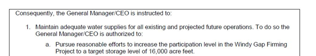


79 C-1
80 C-1
City and County of Broomfield, Colorado CITY COUNCIL AGENDA MEMORANDUM. 11f - Page 1
 To: From: Prepared by: Agenda Title: CITY COUNCIL AGENDA MEMORANDUM Mayor and City Council Charles Ozaki, City and County Manager Jim Becklenberg, Assistant City and County Manager David Allen, Director
Fort Collins WSDMP Update Additional Supplies and Facilities. Community Working Group Meeting #4 June 22, 2011
 Fort Collins WSDMP Update Additional Supplies and Facilities Community Working Group Meeting #4 June 22, 2011 1 Overview Existing water demands and supply system Future water demands Alternatives for meeting
Colorado Division of Water Resources
 Colorado Division of Water Resources Water Literate Leaders of Northern Colorado September 14, 2017 Dave Nettles, Division Engineer Mark Simpson, Poudre Water Commissioner Jean Lever, Thompson Water Commissioner
Stanley J. Woodcock, Michael Thiemann, and Larry E. Brazil Riverside Technology, inc., Fort Collins, Colorado
 7.5 FRASER RIVER EXTENDED STREAMFLOW PREDICTION SYSTEM Stanley J. Woodcock, Michael Thiemann, and Larry E. Brazil Riverside Technology, inc., Fort Collins, Colorado Esther Vincent and Andy Pineda * Northern
The State of the Colorado River
 April 2014 The State of the Colorado River Executive Summary The Colorado River Basin is now in its fifteenth year of drought. System runoff during this period has been comparable to or less than that
Water Conservation Plan February 12, 2009
 February 12, 2009 Prepared by: Peter Mayer, Aquacraft, Inc. Laurie D Audney & Dennis Bode, TABLE OF CONTENTS EXECUTIVE SUMMARY... 1 KEY UTILITY INFORMATION... 3 WATER SYSTEM PROFILE... 3 Physical Characteristics
Raw water sources, facilities, and infrastructure
 WATER AND WASTEWATER SERVICES IN STEAMBOAT SPRINGS Prepared by Jay Gallagher, General Manager Mt. Werner Water and Sanitation District (February, 2015) Raw water sources, facilities, and infrastructure
CHAPTER I INTRODUCTION TO WYOMING WATER ADMINISTRATION
 INTRODUCTION TO WYOMING WATER ADMINISTRATION Section 1. Constitutional Framework. a. The water within the boundaries of Wyoming is declared to be the property of the state by Section 1, Article 8 of the
Beneficial Use of Produced Water: A Case Study of Projects in Colorado and Wyoming
 Beneficial Use of Produced Water: A Case Study of Projects in Colorado and Wyoming D. R. Stewart, PhD, PE* and L. Takichi, PE Review This paper discusses our combined experience in the beneficial use of
Lake County Success. support through synergistic local partnerships that not only mitigate, but also produce
 Lake County Success Generating Environmental Gains With Geothermal Power By Mark Dellinger, Administrator, Lake County (CA) Sanitation District, and Eliot Allen, Principal, Criterion/Planners Engineers
Los Angeles 3 rd Regional
 Los Angeles 3 rd Regional Investors Conference Los Angeles, California March 31, 2016 Metropolitan Water District of Southern California 1 Metropolitan Water District of of Southern California 2 Metropolitan
Proposed Resolution No , Approving the Agreement with Wright Water Engineers, Inc. for a Non-potable Water System Planning Study
 CITY COUNCIL AGENDA MEMORANDUM City and County of Broomfield, Colorado To: From: Prepared by: Mayor and City Council Charles Ozaki, City and County Manager Jim Becklenberg, Assistant City and County Manager
Introduction to hydrology and the water balance
 Introduction to hydrology and the water balance The science of hydrology The science that describes and predicts the occurrence, circulation and distribution of the earth s water. There are two principal
South Platte River Importance of Return Flows and Replacing Depletions to Down-Stream Water Users
 South Platte River Importance of Return Flows and Replacing Depletions to Down-Stream Water Users American Ground Water Trust Colorado Aquifer Management November 29 th, 2012 Jim Yahn, P.E. North Sterling
Colorado River Challenges Impacts to Southern Arizona
 Colorado River Challenges Impacts to Southern Arizona 2 3 4 5 Colorado River Basics 7 States, 2 Nations Annual Flow 15.0 MAF 40 Million People All of the Major Cities in Southwest 5.5m Irrigated Acres
Spring Forecast Based Operations, Folsom Dam, California
 Spring Forecast Based Operations, Folsom Dam, California Paul E. Pugner, P.E. Chief, Water Management Section Sacramento District U.S. Army 1325 J Street, Room 1126 Sacramento, CA 95814-2922 Tel: (916)
Committee on Water. Desalination as a Water Source
 Committee on Water Committee on Water Desalination as a Water Source Water Supply Reliability for San Diego County NARUC Summer Policy Summit July 17, 2017 Bob Yamada Director of Water Resources San Diego
Nevada Water Law. Water Permits The application process To acquire a water permit, an application must be made on an approved form and filed
 Nevada Water Law An overview Nevada's first water statute was enacted in 1866 and has been amended many times since then. Today, the law serves the people of Nevada by managing the state's valuable water
SLIDES: Status of Southern Nevada Water Authority (SNWA): Third Intake into Lake Mead and Groundwater Project
: Third Intake into Lake Mead and Groundwater Project") University of Colorado Law School Colorado Law Scholarly Commons Western Water Law, Policy and Management: Ripples, Currents, and New Channels for Inquiry (Martz Summer Conference, June 3-5) Getches-Wilkinson
University of Colorado Law School Colorado Law Scholarly Commons Western Water Law, Policy and Management: Ripples, Currents, and New Channels for Inquiry (Martz Summer Conference, June 3-5) Getches-Wilkinson
Securing and Protecting Water Rights and Uses in Arizona
 Securing and Protecting Water Rights and Uses in Arizona L. William Staudenmaier One Arizona Center 400 East Van Buren Street, Suite 1900 Phoenix, Arizona 85004 2202 602.382.6000 602.382 6070 (fax) www.swlaw.com
Utah State Group: Lake Powell Pipeline. Meaghan Stertzer Jon Flechsenhaar Christian Nelson Brandon Shepherd
 Utah State Group: Lake Powell Pipeline Meaghan Stertzer Jon Flechsenhaar Christian Nelson Brandon Shepherd Utah 1922 Colorado River Compact 23% water right equalling to 1.71 million acre feet/year 2nd
Option 11. Divert Water from Miocene and Hendricks Canal to Supply the Ridge
 Integrated Water Resources Plan Option 11 Divert Water from Miocene and Hendricks Canal to Supply the Ridge This option would use water from the Miocene Canal and/or Hendricks Canal for municipal supplies
WATER RESOURCE PROGRAM
 SOUTH PLATTE WATER RESOURCE PROGRAM Establishing a lasting legacy of abundant clean water for waterfowl, wildlife and people Water is an essential resource for life and good health. It is vitally important
Environmental Geography
 Environmental Geography Lecture 13 Water Pollution Lecture 13: Water Pollution I. Water Pollution A. Groundwater B. Surface Water C. Regulation II. Water Use in California 1 I. Water Pollution Types of
Start-up of a Secondary Water Supply Company. and First Phase Design of a Regional System
 Start-up of a Secondary Water Supply Company and First Phase Design of a Regional System by Stephen W. Smith and Amy L. Johnson Abstract. Highland Ditch Company formed the Highland Secondary Water Company
Pipelines and Penstocks Avoiding operational issues throughout the life of your project
 Pipelines and Penstocks Avoiding operational issues throughout the life of your project Presenter Dan Murrer, P.E. 322 East Front Street Suite 200 Boise, ID 83702 Tel. 208.383.6108 Daniel.Murrer@CH2M.com
Platte River Power Authority Overview
 Estes Park Longmont Fort Collins Loveland Platte River Power Authority Overview City of Fort Collins Climate Action Plan Citizen Advisory Committee June 12, 2014 Platte River Power Authority History We
Renovation of the Filters at the Soldier Canyon Filter Plant in Fort Collins, Colorado
 JUST ADD WATER Renovation of the Filters at the Soldier Canyon Filter Plant in Fort Collins, Colorado Thomas M. Getting, P.E., DEE, Filtration Product Manager John Geibel, P.E., Chief Engineer Michael
ARIZONA CONSERVATION REQUIREMENTS. Management Plans MUNICIPAL CONSERVATION REQUIREMENTS
 ARIZONA CONSERVATION REQUIREMENTS Management Plans The Arizona Groundwater Management Code establishes the legal framework for conserving water in Arizona's most populous areas. To help achieve its goals,
SPECIAL BOARD OF DIRECTORS MEETING. 1:00 p.m.
 4677 Overland Avenue San Diego, California 92123 SPECIAL BOARD OF DIRECTORS MEETING Board Room February 13, 2014 1:00 p.m. 1. Call to order. 2. Roll call Determination of a quorum. A. Report on proxies
Sterling and Gilcrest/LaSalle High Groundwater Analysis
 FINAL REPORT Prepared for The State of Colorado, Department of Natural Resources Sterling and Gilcrest/LaSalle High Groundwater Analysis July 2015 Sterling and Gilcrest/LaSalle High Groundwater Analysis
City of San Diego Pure Water Project October 2014
 City of San Diego Pure Water Project October 2014 SDCTA Position: SUPPORT Rationale for Position: Substantial study has demonstrated a potable reuse project within the City of San Diego would be safe,
Drought Contingency Plan
 for San Jacinto River Authority Highlands Division Prepared by San Jacinto River Authority Adopted: March 27, 2014 This page intentionally left blank. Table of Contents Table of Contents Section Page Section
Upper Arkansas Voluntary Flow Management Program. Arkansas Basin Roundtable May 10, 2017
 Upper Arkansas Voluntary Flow Management Program Arkansas Basin Roundtable May 10, 2017 Upper Arkansas Voluntary Flow Management Program For rafting: Minimum flow of 700 cfs at Wellsville between July
NORTH TEXAS MUNICIPAL WATER DISTRICT EAST FORK RAW WATER SUPPLY PROJECT
 NORTH TEXAS MUNICIPAL WATER DISTRICT EAST FORK RAW WATER SUPPLY PROJECT Denise Hickey Agenda NTMWD Background Water Planning East Fork Raw Water Supply Project Overview Benefits Nature Center NTMWD BACKGROUND
Pennsylvania s Chesapeake Bay Tributary Strategy Implementation Plan for Sewage Facilities Planning
 The strategy outlined in this guidance document is intended to supplement existing requirements. Nothing in the strategy shall affect regulatory requirements. The information herein is not an adjudication
Fillmore One to seven million acre-feet in storage depending on calculation assumption; surface area is 20,100 acres.
 Where does the City of Santa Paula obtain its water? Currently, the City of Santa Paula obtains its water supply from the court-adjudicated Santa Paula Groundwater Basin (Basin) and in lieu surface water
Alternative: Utilize San Juan-Chama Project Water
 White Paper July 2002 Alternative: Utilize San Juan-Chama Project Water Acknowledgements: This white paper was produced by Daniel B. Stephens & Associates, Inc., with assistance from the Jemez y Sangre
Open Access Transmission Tariff ATTACHMENT K
 ATTACHMENT K PART I Introduction The Transmission Provider s (herein referred to as Tacoma Power) local transmission planning process will include open planning meetings that Tacoma Power will conduct
Strategic Renewable Water Implementation Plan
 PREPARED FOR CASTLE PINES NORTH METROPOLITAN DISTRICT Strategic Renewable Water Implementation Plan OCTOBER 2015 IMPLEMENTATION REPORT EXECUTIVE SUMMARY... 7 BACKGROUND AND HISTORY... 17 The South Metro
Geography 3511: Introduction to Hydrology
 Geography 3511: Introduction to Hydrology Class materials are posted on the GEOG 3511 website. The GEOG 3511 website, part of the Department of Geography website, is located under undergrads, Courses Current
Ingham County Drain Commissioner Patrick E. Lindemann 707 BUHL AVENUE P. O. BOX 220 MASON MI PH. (517) FAX (517)
 FAX (517)") Date Issued Ingham County Drain Commissioner Patrick E. Lindemann 707 BUHL AVENUE P. O. BOX 220 MASON MI 48854 PH. (517) 676-8395 FAX (517) 676-8364 APPLICATION FOR SOIL EROSION AND SEDIMENTATION POLLUTION
Date Issued Ingham County Drain Commissioner Patrick E. Lindemann 707 BUHL AVENUE P. O. BOX 220 MASON MI 48854 PH. (517) 676-8395 FAX (517) 676-8364 APPLICATION FOR SOIL EROSION AND SEDIMENTATION POLLUTION
E1/92. D.C. Water & Sewer Authority Series 2017 A Senior Lien Revenue Bonds. Green Evaluation. Transaction Overview. Green Evaluation Overview
 Green Evaluation D.C. Water & Sewer Authority Series 2017 A Senior Lien Revenue Bonds Transaction Overview In January 2017, the District of Columbia Water & Sewer Authority issued $100 million in series
Issue paper: Aquifer Water Balance
 Issue paper: Aquifer Water Balance 1. Introduction And Background 1.1. Purpose and Scope The population in Kitsap County has grown rapidly in recent years and is expected to increase substantially in the
Overview of Truckee Meadows Water Resources
 Overview of Truckee Meadows Water Resources SB487 Legislative Committee February 25, 2008 EXHIBIT D WESTERN WATER Document consists of 21 pages. Entire Exhibit provided. Meeting Date: 2-25-08 Total Water
Dual Water Systems in Northern Colorado. Wayne E. Eckas, P.E. Aqua Engineering, Inc., Fort Collins, Colorado
 Dual Water Systems in Northern Colorado By Wayne E. Eckas, P.E. Aqua Engineering, Inc., Fort Collins, Colorado In northern Colorado, the cost of water rights acquisition has risen dramatically over the
GENERAL ASSEMBLY OF NORTH CAROLINA SESSION 2011 SESSION LAW HOUSE BILL 609
 GENERAL ASSEMBLY OF NORTH CAROLINA SESSION 2011 SESSION LAW 2011-374 HOUSE BILL 609 AN ACT TO PROMOTE THE DEVELOPMENT OF WATER SUPPLY RESERVOIRS AND OTHER WATER SUPPLY RESOURCES, TO PROVIDE THAT FUNDS
fcgov.com/water-quality Water Quality Update Summer 2017 Monitoring and Protecting Our Water Sources
 Water Quality Update Summer 217 Monitoring and Protecting Our Water Sources SOURCE WATER MONITORING The Upper Cache la Poudre (UCLP) Watershed Collaborative Monitoring Program was established in 28 between
OPERATIONS IN THE MONO BASIN*
 LOS ANGELES DEPARTMENT OF WATER AND POWER OPERATIONS IN THE MONO BASIN* I APPRECIATE THIS OPPORTUNITY TO COMMENT ON THE DEPARTMENT'S WATER GATHERING OPERATIONS IN THE MONO BASIN AND THE RESULTING IMPACT
MAJOR THEMES IN ARIZONA S WATER FUTURE
 Chapter 2 MAJOR THEMES IN ARIZONA S WATER FUTURE KATHY JACOBS AND MARSHALL A. WORDEN Seven major themes or overarching concerns regarding Arizona s water future are discussed in succeeding chapters. Information
Demand and Yield Analysis Final
 RAW WATER SOURCE ALTERNATIVES STUDY Demand and Yield Analysis Final April 2009 Prepared for: Ute Water Conservancy District P.O. Box 460 Grand Junction, CO 81502 Prepared by: 8181 East Tufts Avenue Denver,
ANNUAL PLATTE RIVER SURFACE WATER FLOW SUMMARY
 ANNUAL PLATTE RIVER SURFACE WATER FLOW SUMMARY 4/3/213 Platte River Recovery Implementation Program 213 ANNUAL SURFACE WATER FLOW SUMMARY DRAFT Prepared by staff of the Platte River Recovery Implementation
Background Paper 81-7 REVIEW OF THE MARLETTE LAKE WATER SYSTEM AND PROPOSALS FOR SALE OF THE SYSTEM OR WATER FROM THE SYSTEM TO CARSON CITY
 Background Paper 81-7 REVIEW OF THE MARLETTE LAKE WATER SYSTEM AND PROPOSALS FOR SALE OF THE SYSTEM OR WATER FROM THE SYSTEM TO CARSON CITY Review of the Marlette Lake Water System and Proposals for Sale
FINDINGS: Olsson used a three-step analysis strategy to develop a benefit cost ratio that would indicate the relative feasibility of this project.
 EXECUTIVE SUMMARY FINDINGS: Based on the results of this feasibility study, the Platte Republican Diversion Project would be cost-effective. With minimal improvements to the channel, and the existing bridge
TABLE OF CONTENTS 4.17 UTILITIES AND SERVICE SYSTEMS...
 TABLE OF CONTENTS 4.17 UTILITIES AND SERVICE SYSTEMS... 4.17-1 4.17.0 Introduction... 4.17-1 4.17.1 Methodology... 4.17-2 4.17.2 Existing Conditions... 4.17-2 4.17.3 Impacts... 4.17-4 4.17.4 Applicant-Proposed
Indirect Reuse with Multiple Benefits The El Monte Valley Mining, Reclamation, and Groundwater Recharge Project
 ABSTRACT & POWERPOINT PRESENTATION Indirect Reuse with Multiple Benefits The El Monte Valley Mining, Reclamation, and Groundwater Recharge Project Tim Smith Principal Engineer Helix Water District La Mesa,
CHAPTER 5 WASTEWATER FLOWS
 CHAPTER 5 WASTEWATER FLOWS 5.1 REGIONAL FACILITIES Regional Water Recycling Plants Figure 5-1 illustrates the service area boundaries for IEUA s four water recycling plants. The four Regional facilities
The Central Utah Project
 The Central Utah Project Introduction The Central Utah Project ("CUP") has been in formal existence for over 3 decades and will provide part of the water supply for Salt Lake City's future needs. On May
PREPARE60 OVERVIEW 1
 PREPARE60 OVERVIEW 1 UTAH S WATER BUDGET Category Total precipitation 61,500,000 Used by vegetation & natural systems 53,789,000 Basin Yield 7,711,000 Compact decreases 535,000 Ground water mining increases
Engineering and Hydrologic Issues in Changing Water Uses
 University of Colorado Law School Colorado Law Scholarly Commons Colorado Water Issues and Options: The 90's and Beyond: Toward Maximum Beneficial Use of Colorado's Water Resources (October 8) Getches-Wilkinson
Date: Wednesday, October 4, Location: Western Municipal Water District Board Room Meridian Parkway, Riverside, 92518
 Date: Wednesday, October 4, 2017 Time: 6 p.m. WESTERN MUNICIPAL WATER DISTRICT NEW DATE SCHEDULED FOR PUBLIC HEARING Proposed Increases in Water Rates and Service Charges Location: Western Municipal Water
Wastewater ENVIRONMENTAL SETTING. Wastewater Collection
 4.15.3.1 ENVIRONMENTAL SETTING Wastewater Collection The City owns, operates, and maintains the local sewer lines that collect wastewater generated within the City. The existing sewer lines include a gravity
TAUSSIG. & Associates, Inc. DAVID. Public Finance Facilities Planning Urban Economics CAPACITY FEE STUDY FOR SAN GORGONIO PASS WATER AGENCY
 DAVID TAUSSIG & Associates, Inc. CAPACITY FEE STUDY FOR SAN GORGONIO PASS WATER AGENCY JULY 21, 2015 Public Finance Facilities Planning Urban Economics Newport Beach Riverside San Francisco Chicago CAPACITY
TECHNICAL EVALUATION OF OPTIONS FOR LONG-TERM AUGMENTATION OF THE COLORADO RIVER SYSTEM
 TECHNICAL EVALUATION OF OPTIONS FOR LONG-TERM AUGMENTATION OF THE COLORADO RIVER SYSTEM REDUCTION OF POWER PLANT CONSUMPTIVE WATER USAGE FOR COLORADO RIVER AUGMENTATION BY: RICHARD W. HAYSLETT, P.E. BLACK
U.S. Water Budget. Figure Source:Data from The Nation s Water Resources , Vol. 1, U.S. Water Resources Council.
 U.S. Water Budget Figure 10.18 10-9 Source:Data from The Nation s Water Resources 1975-2000, Vol. 1, U.S. Water Resources Council. Average U.S. Precipitation Figure 10.19 10-10 Source: U.S. Water Resources
The Board of Finance of Baltimore City Department of Finance Bureau of Treasury Management
 The Board of Finance of Baltimore City Department of Finance Bureau of Treasury Management Tax Increment Financing Policy and Project Submission Requirements January 23, 2012 PART I: TAX INCREMENT FINANCING
Understanding Stormwater Pollution Prevention Plans (SWPPPs) (SWPPPS)
 (SWPPPS)") Understanding Stormwater Pollution Prevention Plans (SWPPPs) (SWPPPS) Definitions SWPPP: Storm Water Pollution Prevention Plan BMP: Best Management Practice(s) to control pollution IDNR: Iowa Department
Understanding Stormwater Pollution Prevention Plans (SWPPPs) (SWPPPS) Definitions SWPPP: Storm Water Pollution Prevention Plan BMP: Best Management Practice(s) to control pollution IDNR: Iowa Department
Pipelines to Nowhere? Structural Responses to Climate Change and Population
 Pipelines to Nowhere? Structural Responses to Climate Change and Population Presented by James Lochhead, Esq. Brownstein Hyatt Farber Schreck, LLP bhfs.com Evolving Strategies of Water Supply Development
Questions and Answers about the Water Supply and Water Quality bond act for the November, 2018 ballot. Updated November 17, 2017
 Questions and Answers about the Water Supply and Water Quality bond act for the November, 2018 ballot. Updated November 17, 2017 What is the need for more State investment in water resources? What is the
Environmental Information Worksheet
 Environmental Information Worksheet Water System Owner (Attach additional sheets if necessary) Needs and Alternatives Provide a brief narrative that describes: Current drinking water system needs. Project
For information on water pollution, see our Fact Sheet on Pollution.
 1 Water Management Water Management Last updated: 2010 These Fact Sheets are a guide only and are no substitute for legal advice. To request free initial legal advice on an environmental or planning law
Central Valley Project (CVP) Operations: In Brief
 Operations: In Brief") Central Valley Project (CVP) Operations: In Brief Charles V. Stern Specialist in Natural Resources Policy Pervaze A. Sheikh Specialist in Natural Resources Policy Betsy A. Cody Acting Senior Advisor to
Central Valley Project (CVP) Operations: In Brief Charles V. Stern Specialist in Natural Resources Policy Pervaze A. Sheikh Specialist in Natural Resources Policy Betsy A. Cody Acting Senior Advisor to
SB 838: Oregon Renewable Energy Act Establishing an Oregon Renewable Energy Standard
 SB 838: Oregon Renewable Energy Act Establishing an Oregon Renewable Energy Standard Section-by-Section Summary SB 838, C-engrossed version As passed by Oregon House of Representatives, May 23 rd, 2007.
Eska Creek Preliminary Feasibility Analysis
 Introduction Eska Creek Preliminary Feasibility Analysis This report examines the feasibility issues of energy and economics for a 1.8 MW hydroelectric project on Eska Creek (project). The Project is located
3.0 MANAGEMENT ISSUES AND RECOMMENDATIONS
 3.0 MANAGEMENT ISSUES AND RECOMMENDATIONS The purpose of this section is to describe some of the policies and issues related to the management of groundwater resources and identify recommended actions.
RED RIVER FLOODWAY OPERATION REPORT SPRING Manitoba Infrastructure
 RED RIVER FLOODWAY OPERATION REPORT SPRING 2017 Manitoba Infrastructure RED RIVER FLOODWAY OPERATION REPORT SPRING 2017 June 29, 2017 Manitoba Infrastructure Hydrologic Forecasting and Water Management
John M. Stomp III, PE
 A Dynamic Simulation Model for Integrated Water Resources Management in Albuquerque, NM John M. Stomp III, PE Chief Operating Officer, Albuquerque Bernalillo County Water Utility Authority November 2013
DRAFT FINAL REPORT. City of Kalispell. Stormwater Impact Fee Study
 DRAFT FINAL REPORT City of Kalispell Stormwater Impact Fee Study April 2017 April 13, 2017 Ms. Susie Turner, P.E. Public Works Director City of Kalispell 201 First Avenue East Kalispell, MT 59901 Subject:
PJM Manual 21: Rules and Procedures for Determination of Generating Capability Revision: 12 Effective Date: January 1, 2017
 PJM Manual 21: Rules and Procedures for Determination of Generating Capability Revision: 12 Effective Date: January 1, 2017 Prepared by System Planning Department PJM 2017 Table of Contents Table of Contents
STATE OF MINNESOTA MINNESOTA POLLUTION CONTROL AGENCY FINDINGS OF FACT
 STATE OF MINNESOTA MINNESOTA POLLUTION CONTROL AGENCY IN THE MATTER OF THE DECISION ON THE NEED FOR AN ENVIRONMENTAL IMPACT STATEMENT FOR THE PROPOSED LESTER PRAIRIE WASTEWATER TREATMENT FACILITY EXPANSION
LANDFILL CLOSURE PLAN ENTERGY ARKANSAS, INC. INDEPENDENCE PLANT CLASS 3N CCR LANDFILL PERMIT NO S3N-R2 AFIN
 LANDFILL CLOSURE PLAN ENTERGY ARKANSAS, INC. INDEPENDENCE PLANT CLASS 3N CCR LANDFILL PERMIT NO. 0200-S3N-R2 AFIN 32-00042 OCTOBER 12, 2016 LANDFILL CLOSURE PLAN ENTERGY ARKANSAS, INC. INDEPENDENCE PLANT
TAHOE TRUCKEE SANITATION AGENCY WASTEWATER TREATMENT INQUIRY
 TAHOE TRUCKEE SANITATION AGENCY WASTEWATER TREATMENT INQUIRY REASON FOR INVESTIGATION The 2003-2004 Grand Jury investigated the status of wastewater treatment in unincorporated Nevada County. This year,
How do we meet current and future water needs? Niklas Christensen, PE Watershed Professionals Network
 How do we meet current and future water needs? Niklas Christensen, PE Watershed Professionals Network Objectives of Basin Study Analyze water supply and demand, include climate change Analyze how existing
134 FERC 61,195 UNITED STATES OF AMERICA FEDERAL ENERGY REGULATORY COMMISSION
 134 FERC 61,195 UNITED STATES OF AMERICA FEDERAL ENERGY REGULATORY COMMISSION Before Commissioners: Jon Wellinghoff, Chairman; Marc Spitzer, Philip D. Moeller, John R. Norris, and Cheryl A. LaFleur. Southern
A joint effort of the Orange County Water District and Orange County Sanitation District
 A joint effort of the Orange County Water District and Orange County Sanitation District Orange County Water District OCWD, formed in 1933, is responsible for managing and protecting the Orange County
Attachment E2. Drought Indices Calculation Methods and Applicability to Colfax County
 Attachment E2 Drought Indices Calculation Methods and Applicability to Colfax County Attachment E2. Drought Indices Methodology and Applicability to Colfax County E2.1 Palmer Drought Severity Index E2.1.1
Technical Memorandum
 An Atkins Company Technical Memorandum To: From: Mac Hatcher, PM Collier County Moris Cabezas, PBS&J Ed Cronyn, PBS&J Date: Re: Watershed Model Update Contract 08-5122, PO 4500106318 Element 4, Task 1,
REQUEST FOR QUALIFICATIONS (RFQ) For Engineering Services Institute for Marine Mammal Studies (IMMS)
 For Engineering Services Institute for Marine Mammal Studies (IMMS)") REQUEST FOR QUALIFICATIONS (RFQ) For Engineering Services Institute for Marine Mammal Studies (IMMS) The IMMS is soliciting qualification statements for engineering services to assist the IMMS with the
REQUEST FOR QUALIFICATIONS (RFQ) For Engineering Services Institute for Marine Mammal Studies (IMMS) The IMMS is soliciting qualification statements for engineering services to assist the IMMS with the
Compilation of Benefits and Costs of STA and Reservoir Projects in the South Florida Water Management District
 Compilation of Benefits and Costs of STA and Reservoir Projects in the South Florida Water Management District Report Prepared by Hazen and Sawyer For the World Wildlife Fund acting on behalf of the Florida
Seepage Losses for the Rio Grande Project (Franklin Canal Case Study)
") Seepage Losses for the Rio Grande Project (Franklin Canal Case Study) Zhuping Sheng, Ph.D., P.E. Yaqi Wanyan, M.S., EIT Luis S. Aristizabal Kadambari Reddy, M.S., EIT TAMU, Agricultural Research and Extension
Seepage Losses for the Rio Grande Project (Franklin Canal Case Study) Zhuping Sheng, Ph.D., P.E. Yaqi Wanyan, M.S., EIT Luis S. Aristizabal Kadambari Reddy, M.S., EIT TAMU, Agricultural Research and Extension
Ithaca Area Intermunicipal Cooperation NYAWWA Conference. Chris Bordlemay Padilla Cornell University Water Manager 4/27/17
 Ithaca Area Intermunicipal Cooperation NYAWWA Conference Chris Bordlemay Padilla Cornell University Water Manager 4/27/17 Three Water Purveyors in Ithaca Area Cornell University City of Ithaca Bolton Point
AUTHORITY OF THE BOROUGH OF CHARLEROI WASHINGTON COUNTY, PENNSYLVANIA ACT 537 SEWAGE FACILITIES PLAN UPDATE
 PLAN SUMMARY AUTHORITY OF THE BOROUGH OF CHARLEROI WASHINGTON COUNTY, PENNSYLVANIA ACT 537 SEWAGE FACILITIES PLAN UPDATE The Pennsylvania Sewage Facilities Act (Act 537) was enacted by the Pennsylvania
Private Sewage Systems Standard of Practice Proposed Revisions
 Private Sewage Systems Standard of Practice Proposed Revisions The Government of Alberta is currently reviewing the Standard of Practice (SOP) for Private Sewage Systems. To this end, the Alberta government
Highlights of South Platte Protection Plan
 Summer, 2001 Highlights of South Platte Protection Plan The South Platte Protection Plan has been developed by local communities and interested parties to protect and enhance natural and recreational values
Hydropower Project License Summary PIT RIVER, CA PIT 1 HYDROELECTRIC PROJECT (P-2687) Pit River below Pit 1 Powerhouse
 Pit River below Pit 1 Powerhouse") Hydropower Project License Summary PIT RIVER, CA PIT 1 HYDROELECTRIC PROJECT (P-2687) Pit River below Pit 1 Powerhouse Photo: Hydropower Reform Coalition This summary was produced by the Hydropower Reform
Hydropower Project License Summary PIT RIVER, CA PIT 1 HYDROELECTRIC PROJECT (P-2687) Pit River below Pit 1 Powerhouse Photo: Hydropower Reform Coalition This summary was produced by the Hydropower Reform
System Plan Components Inventory
 Northeast San Joaquin County Groundwater Bank System Plan Components Inventory Northeast San Joaquin County Groundwater Banking Authority April, 2002 The Northeast San Joaquin County Groundwater Banking
DES MOINES RIVER RESERVOIRS WATER CONTROL PLAN UPDATES IOWA ASCE WATER RESOURCES DESIGN CONFERENCE
 DES MOINES RIVER RESERVOIRS WATER CONTROL PLAN UPDATES 237 237 237 217 217 217 200 200 200 0 0 0 163 163 163 131 132 122 80 119 27 252 174.59 110 135 120 112 92 56 IOWA ASCE WATER RESOURCES DESIGN CONFERENCE
Northern Arizona Hydrogeology
 Northern Arizona Hydrogeology Some basics Coconino Plateau Hydrogeology Flagstaff and Coconino Plateau Water Resources Well development, City of Flagstaff Effluent discharge to the Rio de Flag from Wildcat
Water System Optimization: An Energy Efficiency View
 ABSTRACT Water System Optimization: An Energy Efficiency View Noah Mundt, Siemens Industry, Inc. James Dodenhoff, DNV GL Energy Services USA, Inc. Water and energy are inextricably linked in the hydrologic
New Mexico WATER RIGHTS FACT SHEET. August 15, 2001
 New Mexico WATER RIGHTS FACT SHEET August 15, 2001 Water Rights System: New Mexico s water law is based on the doctrine of prior appropriation or "first in time - first in right. All waters in New Mexico