MEMORANDUM. Suwannee River Water Management District Governing Board. Tom Mirti, Interim Division Director, Water Resources
|
|
|
- Jemimah Oliver
- 6 years ago
- Views:
Transcription
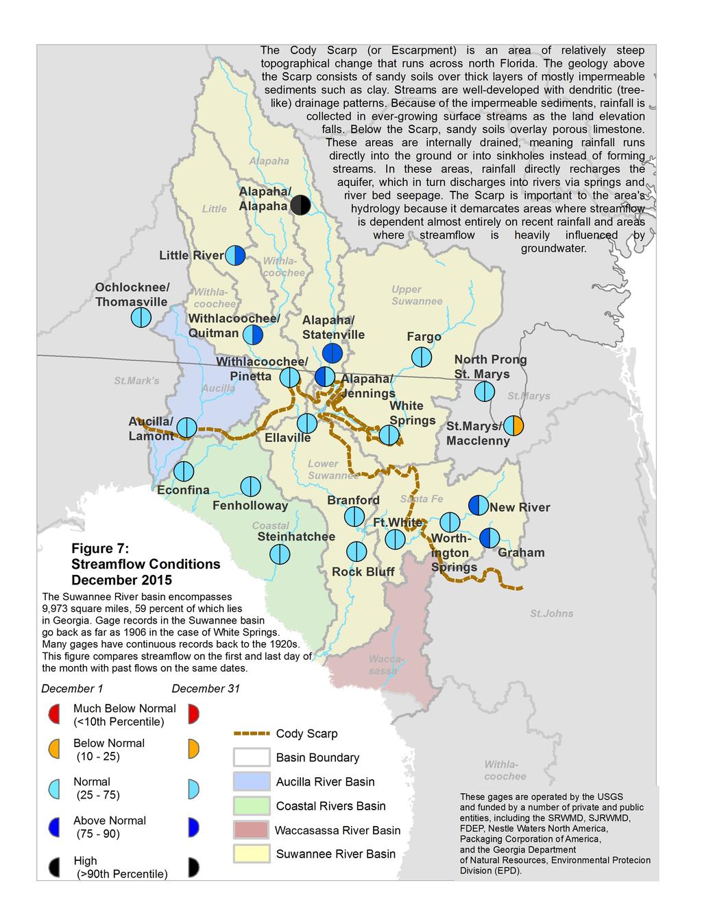
1 MEMORANDUM TO: FROM: THRU: Suwannee River Water Management District Governing Board Tom Mirti, Interim Division Director, Water Resources Noah Valenstein, Executive Director DATE: January, 2015 RE: December 2015 Hydrologic Conditions Report for the SRWMD RAINFALL District-wide rainfall in December was 1.80, a little over half of the long-term average December rainfall of All areas of the District experienced below-average rainfall, although parts of Taylor and Madison counties received over 5. Union and Baker counties received an inch or less on average during the month; about a third of the December average amount (Table 1 and Figure 1). Lower rainfall amounts of below an inch predominated in the northeast part of the District and along the New River corridor between Union and Bradford counties (Figure 2). However, rainfall amounts in the Georgia portion of the Suwannee River basin were well above average--particularly in the upper Withlacoochee and Alapaha basins--where broad areas received up to twice the monthly rainfall average (Figure 3). The highest gaged monthly rainfall total (4.90 ) was recorded at the Hopewell Tower rainfall station in southern Madison County, and the highest daily total (2.16 on December 17) was recorded at the Madison Blue Spring rainfall station in eastern Madison County. The lowest gaged monthly total was 0.56 at Suwannee Valley Experimental Station in Suwannee County. The rainfall average across the District for the 12-month period ending December 31 was.2, compared to the long-term average of 54.6". The cumulative 12-month deficit increased again to 4.4. Rainfall deficits in the western Santa Fe River basin expanded during the month; areas in the Ichetucknee River basin in southern Columbia County are 15 below normal for the year. Cumulative rainfall surpluses persist in the southern portion of the District on a line from Horseshoe Beach to Gainesville (Figure 4). Average District rainfall for the 3 months ending December 31 totaled 6.0, about 30 percent below the long-term average of 8.6. The northwestern portion of the District exhibits the largest 3 month surpluses, although these are generally below 5. The largest 3-month deficits remain concentrated in Suwannee and Columbia counties (Figure 5). SURFACEWATER Rivers: All major river level stations in the District began the month at or above the normal range of flows (between the 25 th and the 75 th percentiles), with above normal conditions present in the Upper Santa Fe and Alapaha River basins. The relatively light December rains in the southeastern basins meant decreases in the Santa Fe River stations back to normal flows, while coastal rivers and the Suwannee River stations above Branford increased but remained within the normal range. Suwannee River tributaries in Georgia either remained at above normal flows (above the 75 th percentile) or increased to those levels during the month as a result of the high rainfall totals there. Flow statistics for major river stations are presented graphically in Figure 6, and river level conditions relative to historic conditions are provided in Figure 7. Lakes: Most District monitored lakes declined in stage during December; 6 of 14 are at below average levels. Waters Lake in Gilchrist County declined the greatest amount, at -1.0, while Sneads Smokehouse Lake in Jefferson County increased by 1.4 after
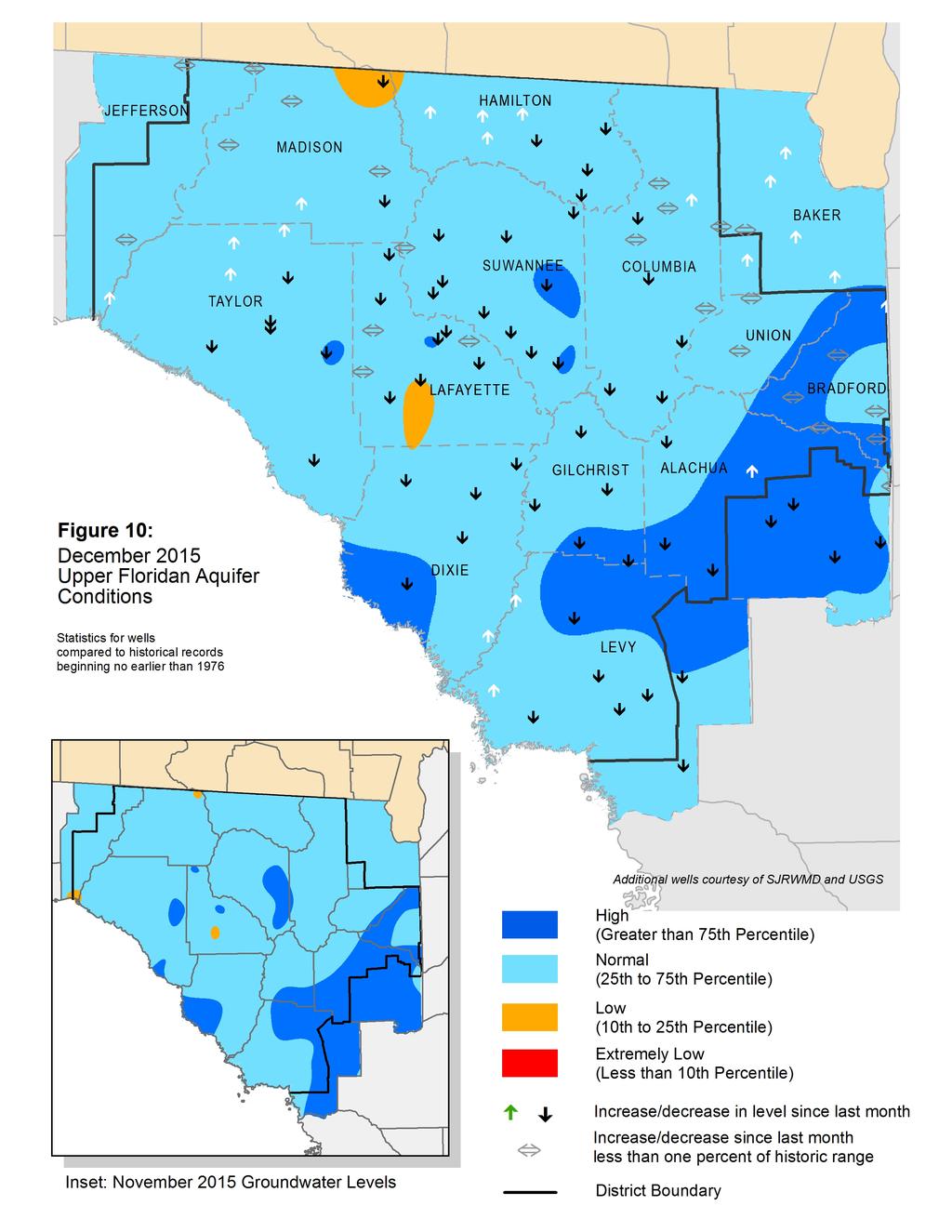
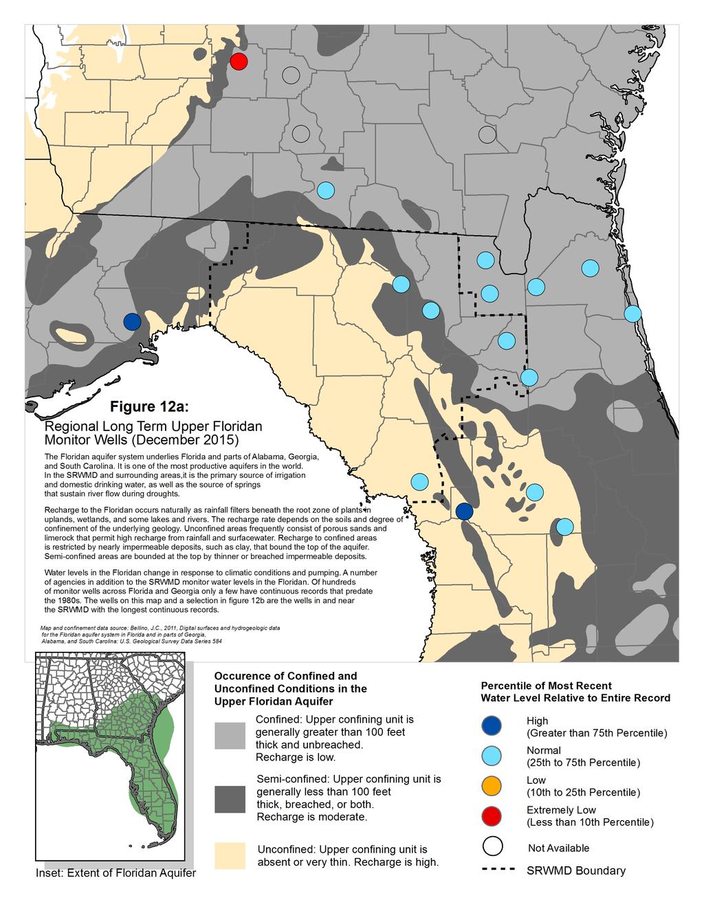
2 several months at or near its minimum. Figure 8 shows lake levels relative to their respective long-term minimum, average and maximum levels. Springs: The flow of 27 springs or spring groups were measured by the USGS, District staff, and District contractors during December. Springflows overall increased slightly. Historical flow data for four of the measured springs are provided in Figure 9. GROUNDWATER Groundwater levels in upper Floridan aquifer monitor wells continued to decrease across most areas of the District and ended the month at the 57 th percentile, a decrease of 2 percentile points from November. The southeastern region of the District remains in the high groundwater level category (above the 75 th percentile). Virtually all of the remainder of the District is in the normal range, with two small low range areas (below the 25 th percentile) in Lafayette and northeastern Madison counties (Figure ). Floridan aquifer levels for a representative sample of long-term wells are provided in Figure 11 along with summary statistics, and regional longterm well status is provided in Figure 12 with a description of aquifer characteristics. HYDROLOGICAL/METEOROLOGICAL INFORMATION The Palmer Drought Severity Index (PDSI), a climatological tool produced by the National Climatic Data Center, assesses the severity and frequency of abnormally dry or wet weather using rainfall, temperature, and soil moisture data. PDSI values for the week ending January 2 showed ongoing near-normal conditions in north Florida and southern Georgia. The National Weather Service Climate Prediction Center (CPC) is forecasting abovenormal rainfall conditions for January and now projects them to continue through May for north Florida. The current El Niño 3.4 Index level is 2.6, indicating a strong event is in place, and the CPC is projecting strengthening to an index level of 2.8 by the end of January. The current level exceeds the El Niño event peak by 0.3 index units. The U.S. Drought Monitor report of January 5 indicated abnormally dry conditions in a band from Dixie County north through Hamilton County. The remainder of the District is within normal conditions. CONSERVATION Water conservation is necessary to sustain healthy flows in springs and rivers. All users are urged to eliminate unnecessary uses. Landscape irrigation is limited to twice per week during Daylight Savings Time (between March 9 and October 31, 2015) based on a water conservation rule that applies to residential landscaping, public or commercial recreation areas, and businesses that aren t regulated by a District-issued permit. Information about the SRWMD s year-round irrigation conservation measures is available at This report is compiled in compliance with Chapter 40B , Florida Administrative Code, using rainfall (radar-derived estimate), groundwater (5 wells), surfacewater (35 stations), and general information such as drought indices and forecasts. Data are provisional and are updated as revised data become available. Data are available at or by request. 2
3 Table 1: Estimated Rainfall Totals (inches) December December Month % Last Annual % County 2015 Average of Normal 12 Months of Normal Alachua % % Baker % % Bradford % % Columbia %.18 98% Dixie % % Gilchrist % % Hamilton % % Jefferson % % Lafayette % % Levy % % Madison % % Suwannee % % Taylor % % Union % % December 2015 Average: December Average ( ): Historical 12-month Average ( ): Past 12-Month Total: 12-Month Rainfall Surplus/Deficit: Figure 1: Comparison of District-wide Monthly Rainfall (Rainfall reported in inches) Rainfall (inches) Dec Past 13 Months Average Maximum Minimum


4 Figure 2: December 2015 Rainfall Estimate Figure 3: December 2015 Percent of Normal Rainfall


5 Figure 4: 12-Month Rainfall Surplus/Deficit by River Basin Through December 31, 2015 Figure 5: 3-Month Rainfall Surplus/Deficit by River Basin Through December 31, 2015
6 Figure 6: Daily River Flow Statistics January 1 through December 31, 2015,000 Suwannee River at Fargo, GA Percentile Past 12 Months Flow Suwannee River at White Springs 00 1, RIVER FLOW, CUBIC FEET PER SECOND 0 Jan 000 Suwannee River at Ellaville 00 0 Jan Withlacoochee River near Pinetta Jan 000 Suwannee River at Branford 00 0 Jan 000 Alapaha River near Statenville Jan Jan
7 Figure 6, cont: Daily River Flow Statistics January 1 through December 31, Santa Fe River at Worthington Springs Percentile Past 12 Months Flow Santa Fe River near Fort White above SR47 Bridge RIVER FLOW, CUBIC FEET PER SECOND 0.1 Jan New River near Lake Butler on SR Jan 300 Jan 0 Steinhatchee River above US Jan Econfina River on Salt Road above US 98 Fenholloway River at US Jan 0.1 Jan
8


9 Feet Above or Below Historic Average Figure 8: December 2015 Lake Levels SRWMD lakes react differently to climatic changes depending on their location in the landscape. Some lakes, in particular ones in the eastern part of the District, are embedded in a surficial or intermediate aquifer over relatively impermeable clay deposits. These lakes rise and fall according to local rainfall and surface runoff. They retain water during severe droughts since most losses occur from evaporation. Other lakes, such as Governor Hill and Waters Lake, have porous or leaky bottoms that interact with the Floridan aquifer. These lakes depend on groundwater levels to stay high. If aquifer levels are low, these lakes go dry even if rainfall is normal. The District monitors 14 lakes with much of the data originally provided by volunteer observers. Monitoring records begin in the 1970s, except for Lakes Butler, Sampson, and Santa Fe, which started in No Data
10 Figure 9: Monthly Springflow Measurements The SRWMD monitors water quality at 38 springs. Flow is usually measured at the time of the sampling. The springs below were measured in December 2015 by SRWMD staff or by the USGS with the last measurement marked in red. Flow is given in MGD (million gallons per day--a million gallons would fill a football field about 3' deep). With the exception of the Ichetucknee River, Santa Fe Rise and the Alapaha Rise, springs in the SRWMD were measured infrequently prior to the late 1990s. Springs with long records were rarely measured more than once per decade; 'reverse' flow measurements have only been made during the past years. A spring's flow can be greatly affected by the level of the river it runs into. Rising river levels can act like a dam and slow spring flow causing what is known as a backwater effect. A river can flood a spring completely, known colloquially as a "brown-out". If the river levels are high enough, river water can flow back into the spring vent and thence into the aquifer, resulting in a negative flow rate. Because of the interaction between a spring and its receiving water body, some low flow measurements recorded are the result of river flooding and not necessarily drought conditions Madison Blue Spring Troy Spring Spring Flow, Million Gallons per Day Royal Spring Jug Spring
11
12 Figure 11: Monthly Groundwater Level Statistics Levels January 1 through December 31, 2015 Period of Record Beginning 1978 Maximum Average Since 1978 Minimum Past 12 Months 85 Madison County N near Greenville Suwannee County S near Live Oak Upper Floridan Aquifer Elevation above NGVD 1929, Feet Columbia County S Lake City Lafayette County S near Mayo Hamilton County N near Jasper Taylor County S0701 near Perry
13 Figure 11, cont.: Groundwater Level Statistics Levels January 1 through December 31, 2015 Period of Record Beginning 1978 Maximum Average Since 1978 Minimum Past 12 Months 64 Union County S near Lake Butler 43.0 Alachua County S at High Springs Upper Floridan Aquifer Elevation above NGVD 1929, Feet Gilchrist County S near Trenton Dixie County S1201 at Cross City Bradford County S near Graham Levy County S near Bronson
14

15 Figure 12b: Regional Long Term Upper Floridan Levels December Poucher Well Suwannee County 1961 Taylor and Sanderson Wells courtesy of SJRWMD Upper Floridan Aquifer Elevation above NGVD 1929, Feet USGS Taylor Well Baker County DOT Lake City Well Columbia County USGS Sanderson Well Baker County 1963 USGS Raiford Well Bradford County 1959
MEMORANDUM. Suwannee River Water Management District Governing Board
 MEMORANDUM TO: FROM: THRU: Suwannee River Water Management District Governing Board Tom Mirti, Director, Division of Water Resources Noah Valenstein, Executive Director DATE: April 7, 2016 RE: March 2016
Figure 1: Comparison of District Monthly Rainfall
 Table 1: Estimated Rainfall Totals July Month % Last Annual % County July 2013 Average of Normal 12 Months of Normal Alachua 11.33 7.01 162% 56.85 111% Baker 8. 7.06 122% 49.90 0% Bradford 8.11 6.92 117%
MEMORANDUM. February 2015 Hydrologic Conditions Report for the Suwannee River Water Management District
 MEMORANDUM TO: FROM: THRU: Governing Board Tom Mirti, Chief, Bureau of Hydrologic Data Services Ann B. Shortelle, Ph.D., Executive Director Erich Marzolf, Ph.D., Division Director, Water Resources DATE:
MEMORANDUM. Governing Board. Megan Wetherington, P.E., Senior Professional Engineer
 MEMORANDUM TO: FROM: THRU: Governing Board Megan Wetherington, P.E., Senior Professional Engineer Ann B. Shortelle, Ph.D., Executive Director Erich Marzolf, Ph.D., Water Resources Division Director DATE:
MEMORANDUM. Governing Board. Megan Wetherington, P.E., Senior Professional Engineer
 MEMORANDUM TO: FROM: THRU: Governing Board Megan Wetherington, P.E., Senior Professional Engineer Ann B. Shortelle, Ph.D., Executive Director Erich Marzolf, Ph.D., Water Resources Division Director DATE:
MEMORANDUM. Governing Board. Megan Wetherington, P.E., Senior Professional Engineer
 MEMORANDUM TO: FROM: THRU: Governing Board Megan Wetherington, P.E., Senior Professional Engineer Ann B. Shortelle, Ph.D., Executive Director Erich Marzolf, Ph.D., Division Director, Water Resources DATE:
MEMORANDUM. Governing Board. Megan Wetherington, P.E., Senior Professional Engineer
 MEMORANDUM TO: FROM: THRU: Governing Board Megan Wetherington, P.E., Senior Professional Engineer Ann B. Shortelle, Ph.D., Executive Director Erich Marzolf, Ph.D., Division Director, Water Resources DATE:
Figure 1: Comparison of District Monthly Rainfall
 Table 1: Estimated Rainfall Totals (inches) September Month % Last Annual % County Sep 2013 Averae of Normal 12 Months of Normal Alachua 4. 5.36 82%.67 99% Baker 2.38 5.44 44% 47.51 95% Bradford 2.29 6.13
MEMORANDUM. Suwannee River Water Management District Governing Board. Tom Mirti, Director, Division of Water and Land Resources
 MEMORANDUM TO: FROM: THRU: Suwannee River Water Manaement District Governin Board Tom Mirti, Director, Division of Water and Land Resources Huh Thomas, Executive Director DATE: ober 8, 2018 RE: tember
MEMORANDUM. Governing Board. Megan Wetherington, P.E., Senior Professional Engineer
 MEMORANDUM TO: FROM: THRU: Governin Board Mean Wetherinton, P.E., Senior Professional Enineer Ann B. Shortelle, Ph.D., Executive Director Erich Marzolf, Ph.D., Water Resources Division Director DATE: February
Suwannee River Water Management District
 Suwannee River Water Management District March 10, 2015 2014 Agricultural Water Use Monitoring Report 9225 C.R. 49 Live Oak, FL 32060 386.362.1001 2014 Agricultural Water Use Monitoring Report Suwannee
Overview of the Draft 2010 Water Supply Assessment Report
 Overview of the Draft 2010 Water Supply Assessment Report Elements of the Water Supply Assessment SRWMD 2010 Water Supply Assessment Statutory Requirements Water Use Demand Projections Assessment of Current
Overview of the Draft 2010 Water Supply Assessment Report. Suwannee River Water Management District
 Overview of the Draft 2010 Water Supply Assessment Report Suwannee River Water Management District Elements of the Water Supply Assessment SRWMD 2010 Water Supply Assessment Statutory Requirements Water
Executive Summary... 1 Chapter 1 Introduction Part 1. Introduction... 17
 i DRAFT Table of Contents Executive Summary... 1 Chapter 1 Introduction... 7 Part 1. Introduction... 7 Part 2. Outreach and Coordination... 9 Part 3. Organization and Content of the Water Supply Assessment...
Illinois in Drought. June 19, 2012, Updated June 21, 2012
 June 19,, Updated June 21, Illinois in Drought The ISWS now considers central and southern Illinois to be fully in drought based on several impacts including the early season onset of reservoir drawdown
September 9, EPB/UNF Environmental Symposium
 September 9, 2016 2016 EPB/UNF Environmental Symposium John Fitzgerald Regional Water Supply Planning Coordinator North Florida Regional Water Supply Partnership North Florida Regional Water Supply Partnership
DRAFT. Water Supply Assessment ( ) W a t e r f o r N a t u r e, W a t e r f o r P e o p l e D AT E
 W a t e r f o r N a t u r e, W a t e r f o r P e o p l e D AT E") 2015 Water Supply Assessment Water for Nature, Water for People 3 DRAFT Water Supply Assessment (2015-2035) W a t e r f o r N a t u r e, W a t e r f o r P e o p l e D AT E Water Supply Assessment (2015-2035)
2015 Water Supply Assessment Water for Nature, Water for People 3 DRAFT Water Supply Assessment (2015-2035) W a t e r f o r N a t u r e, W a t e r f o r P e o p l e D AT E Water Supply Assessment (2015-2035)
Background Information on the. Peace River Basin
 Background Information on the Peace River Basin Resource Conservation & Development Department August 24 Background Physiography The Peace River drainage basin occupies large parts of Polk, Hardee, DeSoto,
Lower Santa Fe River Basin
 Lower Santa Fe River Basin (1/16/14) Water for Nature, Water for Peop Recovery Strategy: Lower Santa Fe River Basin L o w e r S a n t a F e a n d I c h e t u c k n e e R i v e r s a n d P r i o r i t y
PEACE RIVER MANASOTA REGIONAL WATER SUPPLY AUTHORITY BOARD OF DIRECTORS MEETING December 5, 2018 ROUTINE STATUS REPORTS ITEM 1
 PEACE RIVER MANASOTA REGIONAL WATER SUPPLY AUTHORITY BOARD OF DIRECTORS MEETING December 5, 218 ROUTINE STATUS REPORTS ITEM 1 Hydrologic Conditions Report MEMORANDUM Project: Hydrologic Conditions Report
City of Portsmouth Department of Public Works
 City of Portsmouth Department of Public Works August 2, 2018 Portsmouth Water Supply Status Report Overview The following Portsmouth Water Supply Status Report provides the Portsmouth Water customers an
U.S. Geological Survey (USGS) Florida Water-Use Program
 Florida Water-Use Program") U.S. Geological Survey (USGS) Florida Water-Use Program By Richard L. Marella Florida Water Science Center - Orlando U.S. Department of the Interior U.S. Geological Survey USGS Florida Water-Use Program
U.S. Geological Survey (USGS) Florida Water-Use Program By Richard L. Marella Florida Water Science Center - Orlando U.S. Department of the Interior U.S. Geological Survey USGS Florida Water-Use Program
INSTREAM FLOW GUIDELINES AND PROTECTION OF GEORGIA S AQUATIC HABITATS
 INSTREAM FLOW GUIDELINES AND PROTECTION OF GEORGIA S AQUATIC HABITATS Mary M. Davis AUTHOR Aquatic Ecologist, The Nature Conservancy, 133 West Peachtree Street, Suite 41, Atlanta, Georgia 339 REFERENCE
SRWMD Strategic Plan
 SRWMD Strategic Plan 0 SRWMD STRATEGIC PLAN A message from the Chairman During Fiscal Year 2014-2015 the District made significant strides in refining its foundation of science-based decisions by introducing
Nitrate Nitrogen Control Efforts in Floridan Aquifer Springs
 February 16, 2012 Adventures in Ecological Restoration Nitrate Nitrogen Control Efforts in Floridan Aquifer Springs Robert L. Knight, Ph.D. Nitrate in Florida Spring Ecosystems Presentation Outline Healthy
Florida Forever Work Plan
 Florida Forever Work Plan 207 Annual Update SUWANNEE RIVER WATER MANAGEMENT DISTRICT TABLE OF CONTENTS Table of CONTENTS 02-03 Introduction 04-06 Water Resource Development 07-09 0-3 4 Project Restoration
Basin Management Action Plan Suwannee River
 Division of Environmental Assessment and Restoration Basin Management Action Plan Suwannee River Terry.hansen@dep.state.fl.us September, 2013 Welcome Recent DO Criteria, Rule 62-302.533, Florida Administrative
Altamonte Springs FDOT I-4 Storm water Capture and Reclaimed Water Project Phase I
 St. Johns River Water Management District Wekiva Spring Altamonte Springs FDOT I-4 Storm water Capture and Reclaimed Water Project Phase I Project includes construction of a 5.8 mile 20-inch diameter reclaimed
FY2018 Five-Year Water Resource Development Work Program. Suwannee River Water Management District
 FY2018 Five-Year Water Resource Development Work Program Suwannee River Water Management District 10/18/2017 Five-Year Water Resource Development Work Program Suwannee River Water Management District 9225
Contents Background... 2 Recommended MFLs... 3
 Minimum Flows Determination and Status Evaluation of Four Outstanding Florida Springs: Falmouth Spring, Lafayette Blue Spring, Peacock Springs, and Troy Spring May 15, 2017 Suwannee River Water Management
Appendix I. Potential Adverse Change to Wetland Function Methodology and Results
 Appendix I Potential Adverse Change to Wetland Function Methodology and Results Technical Memorandum North Florida Regional Water Supply Plan Potential Adverse Change to Wetland Function January 3, 2017
June 2009: How severe is the current drought in the Hill Country? Raymond M Slade, Jr, PH Certified Professional Hydrologist
 June 2009: How severe is the current drought in the Hill Country? Raymond M Slade, Jr, PH Certified Professional Hydrologist Presentation organization 1. What is drought? 2. Assessment of drought conditions
Relationships Between Discharge And Water Quality In Florida Springs
 Relationships Between Discharge And Water Quality In Florida Springs Erich Marzolf, Ph.D. Ann B. Shortelle, Ph.D. Suwannee River Water Management District Data & Methods Data from SRWMD monitoring efforts,
Water Supply and Water Quality Issues in Suwannee River Basin and Awareness within the Ag Community
 Water Supply and Water Quality Issues in Suwannee River Basin and Awareness within the Ag Community Practicum Decision Suwannee Basin Regulatory Challenges for Agriculture Suwannee River Partnership Practicum
AGENDA DATE: November 14, 2018
 ALAMEDA COUNTY FLOOD CONTROL AND WATER CONSERVATION DISTRICT, ZONE 7 100 NORTH CANYONS PARKWAY, LIVERMORE, CA 94551 PHONE (925) 454-5000 FAX (925) 454-5727 ORIGINATING SECTION: INTEGRATED PLANNING CONTACT:
Appendix 4-2. Groundwater Modeling
 Appendix 4-2. Groundwater Modeling 1.0 Introduction For the WRWSA s 2010 Water Supply Plan, The SWFWMD and SJRWMD used regional groundwater flow models to assess the quantity of groundwater that could
Regional Water Supply Planning
 Regional Water Supply Planning 2015 Annual Report i Front Photo: Ichetucknee Springs State Park Courtesy of Kathleen Greenwood Table of Contents Executive Summary... i Regional Water Supply Planning...
Occurrence of Iron in Surface Waters of the Upper St. Johns River Basin
 Occurrence of Iron in Surface Waters of the Upper St. Johns River Basin Prepared by Florida Department of Environmental Protection Bureau of Watershed Management Ground Water Protection Section December
Exchanges of Water between the Upper Floridan Aquifer and the Lower Suwannee and Lower Santa Fe Rivers, Florida
 Exchanges of Water between the Upper Floridan Aquifer and the Lower Suwannee and Lower Santa Fe Rivers, Florida By J.W. Grubbs and C.A. Crandall Prepared in cooperation with the Suwannee River Water Management
National Integrated Drought Information System Southeast US Pilot for Apalachicola- Chattahooche-Flint River Basin. 14 August 2012
 National Integrated Drought Information System Southeast US Pilot for Apalachicola- Chattahooche-Flint River Basin 14 August 2012 Outline Welcome Keith Ingram, UF, Southeast Climate Consortium Current
SOUTHERN WATER USE CAUTION AREA REVIEW
 COMPONENT Water Supply Mission Components The Southern Water Use Caution Area (SWUCA) was designated in 1992 to address declines in aquifer levels occurring throughout the groundwater basin. Due to growing
Florida Springs Protection and Restoration: Legislation, Projects and Prospects
 Florida Springs Protection and Restoration: Legislation, Projects and Prospects FSA Annual Conference June 2015 Casey Fitzgerald Director, Springs Protection Initiative SJRWMD Florida Springs Presentation
Water Supply Outlook. Interstate Commission on the Potomac River Basin (ICPRB) 30 W. Gude Drive, Suite 450 Rockville, MD Tel: (301)
 30 W. Gude Drive, Suite 450 Rockville, MD Tel: (301)") Water Supply Outlook October 3, 2014 To subscribe: please email sahmed@icprb.org Interstate Commission on the Potomac River Basin (ICPRB) 30 W. Gude Drive, Suite 450 Rockville, MD 20850 Tel: (301) 274
Water Supply Outlook October 3, 2014 To subscribe: please email sahmed@icprb.org Interstate Commission on the Potomac River Basin (ICPRB) 30 W. Gude Drive, Suite 450 Rockville, MD 20850 Tel: (301) 274
Florida. Logistics & Distribution Industry Edition. Source: Florida Department of Economic Opportunity, Bureau of Labor Market Statistics
 L a b o r M a r k e t I n d u s t r y P r o f i l e Florida Logistics & Distribution Industry 2017 Edition Source: Florida Department of Economic Opportunity, Bureau of Labor Market Statistics Florida
Strategic Plan (DRAFT)
") Water for Nature Water for People Strategic Plan (DRAFT) 209-2023 SUWANNEE RIVER WATER MANAGEMENT DISTRICT 03 05 09 3 7 Agency Overview Environmental and Economic Connections Flood Control & Flood Protection
Water for Nature Water for People Strategic Plan (DRAFT) 209-2023 SUWANNEE RIVER WATER MANAGEMENT DISTRICT 03 05 09 3 7 Agency Overview Environmental and Economic Connections Flood Control & Flood Protection
National Integrated Drought Information System Southeast US Pilot for Apalachicola- Flint-Chattahoochee River Basin.
 National Integrated Drought Information System Southeast US Pilot for Apalachicola- Flint-Chattahoochee River Basin 4 December 2012 Outline Welcome Keith Ingram, Southeast Climate Consortium, UF Current
NATURAL RESOURCES OF REGIONAL SIGNIFICANCE
 NATURAL RESOURCES OF REGIONAL SIGNIFICANCE CONDITIONS AND TRENDS INTRODUCTION North central Florida is one of the largest planning districts in the state in terms of area yet one of the smallest in terms
North Florida Regional Water Supply Partnership
 North Florida Regional Water Supply Partnership For more information see http//:northfloridawater.com 2 North Florida Regional Water Supply Partnership Regional water supply planning Stakeholder Advisory
South Florida Water Management District Future Directions. Melissa Meeker, Executive Director
 South Florida Water Management District Future Directions Melissa Meeker, Executive Director September 15, 2011 District Overview Oldest and largest of five water management districts Covers 18,000 square
Water Supply Outlook. Interstate Commission on the Potomac River Basin (ICPRB) 30 W. Gude Drive, Suite 450 Rockville, MD Tel: (301)
 30 W. Gude Drive, Suite 450 Rockville, MD Tel: (301)") Water Supply Outlook June 2, 2015 To subscribe: please email sahmed@icprb.org Interstate Commission on the Potomac River Basin (ICPRB) 30 W. Gude Drive, Suite 450 Rockville, MD 20850 Tel: (301) 274 8120
Water Supply Outlook June 2, 2015 To subscribe: please email sahmed@icprb.org Interstate Commission on the Potomac River Basin (ICPRB) 30 W. Gude Drive, Suite 450 Rockville, MD 20850 Tel: (301) 274 8120
Legislative Committee on Public Lands
 Legislative Committee on Public Lands EXHIBIT D2 May 28, 2004 EXHIBIT D2 Committee Name Lands Document consists of 74 Slides Entire document provided. Due to size limitations, pages provided. A copy of
Santa Fe River. Surface Water Improvement and Management Plan Review Draft June 1, 1995
 Santa Fe River Surface Water Improvement and Management Plan Review Draft June 1, 1995 Suwannee River Water Management District Route 3, Box 64 Live Oak, FL 32060 904-362-1001 800-226-1066 SunCom821-3220
AGENDA ITEM D6. Climate Outlook
 AGENDA ITEM D6 DATE: June 1, 2016 TO: Matt Jordan, General Manager FROM: Alison Adams, Chief Technical Officer SUBJECT: Regional Water Supplies and Member Demands Status Report SUMMARY: RECOMMENDATION:
Water Supply and Resource Management
 Suwannee River Water Management District Governing Board Materials Water Supply and Resource Management The following materials have been reviewed and approved for distribution to the Governing Board and
National Integrated Drought Information System Southeast US Pilot for Apalachicola- Chattahooche-Flint River Basin.
 National Integrated Drought Information System Southeast US Pilot for Apalachicola- Chattahooche-Flint River Basin 25 September 2012 Outline Welcome Keith Ingram, UF, Southeast Climate Consortium Current
AGENDA ITEM C9 TAMPA WATER
 TAMPA WATER Supplying Water To The Region AGENDA ITEM C9 DATE: June 3, 28 TO: Gerald J. Seeber, General Manager FROM: Donald J. Polmann, Director of Science and Engineering SUBJECT: Regional Water Supply
North Central Florida Strategic Regional Policy Plan Summary
 North Central Florida Regional Goals and Policies Regionally Significant Facilities and Resources Maps of Natural Resources of Regional Significance October 2011 North Central Florida Regional Planning
Comments on NFSEG v1.1 Case 007h for Peer Review Panel Consideration. April 18, 2018
 Comments on NFSEG v1.1 Case 007h for Peer Review Panel Consideration April 18, 2018 Introduction NFUCG composed of 8 utilities in northeast Florida Integral to the fabric of our communities Provide high-quality,
SUWANNEE RIVER WATER MANAGEMENT DISTRICT
 SUWANNEE RIVER WATER MANAGEMENT DISTRICT 2007 Strategic Plan 2016 DRAFT A Message from the Chairman Recently, a county within the District was listed by a national business magazine as being among the
florida forever five-year work plan
 florida forever five-year work plan Contents ADA Statement... 2 Introduction... 3 Water Resource Development... 5 Restoration Projects... 10 Land Acquisition and Land Management... 12 Florida Forever Plan
The Springs and. Aquifer System of Florida. Debra Segal, M.S. Volunteer for the Howard T. Odum Florida Springs Institute. Rock Springs, Orange County
 The Springs and Rock Springs, Orange County Aquifer System of Florida Debra Segal, M.S. Volunteer for the Howard T. Odum Florida Springs Institute Who Has Visited a Spring in Florida? Photos by John Moran
Water Supply and Drought Update January 14, 2015
 Water Supply and Drought Update January 14, 2015 Current TRWD reservoir storage capacity: 61.5% Averting Stage 2 drought restrictions not likely --------------------------------------------------------
2016 Reuse Inventory ii
 2016 Inventory May 2017 Florida Department of Environmental Protection Division of Water Resource Management Water Program 2016 Inventory ii 2016 Inventory iii 2016 Inventory Water Program Florida Department
Hydrologic Basis for SLVWD Drought Management Plan presented to SLVWD Board of Directors March 6, 2014
 Hydrologic Basis for SLVWD Drought Management Plan presented to SLVWD Board of Directors March 6, 2014 by Nicholas M. Johnson, Ph.D., P.G., C.Hg. Principal Hydrogeologist, MWH SLVWD Service Areas SLVWD
Fl or i da For e v e r Wor k P l a n Annua l U p da t e
 R ec o v er y S t r a t eg y A R i ve r B a s i n W a t er f o r N a t u r e, W a t er f o r P eo trfrf Fl or i da For e v e r Wor k P l a n 201 6 Annua l U p da t e F I N AL D R A F T F e b r u a r y
Water Supply Outlook. Interstate Commission on the Potomac River Basin (ICPRB) 30 W. Gude Drive, Suite 450 Rockville, MD Tel: (301)
 30 W. Gude Drive, Suite 450 Rockville, MD Tel: (301)") Water Supply Outlook April 2, 2019 To subscribe: please email sahmed@icprb.org Interstate Commission on the Potomac River Basin (ICPRB) 30 W. Gude Drive, Suite 450 Rockville, MD 20850 Tel: (301) 274 8120
Water Supply Outlook April 2, 2019 To subscribe: please email sahmed@icprb.org Interstate Commission on the Potomac River Basin (ICPRB) 30 W. Gude Drive, Suite 450 Rockville, MD 20850 Tel: (301) 274 8120
Technical Memorandum
 Specialists in Agricultural Water Management Serving Stewards of Western Water since 1993 To: From: Technical Memorandum Butte County Department of Water and Resource Conservation Davids Engineering Date:
Song Lake Water Budget
 Song Lake Water Budget Song Lake is located in northern Cortland County. It is a relatively small lake, with a surface area of about 115 acres, and an average depth of about 14 feet. Its maximum depth
National Integrated Drought Information System Southeast US Pilot for Apalachicola- Chattahooche-Flint River Basin. 5 June 2012
 National Integrated Drought Information System Southeast US Pilot for Apalachicola- Chattahooche-Flint River Basin 5 June 2012 Outline Welcome Keith Ingram, UF, Southeast Climate Consortium Current drought
The 2016 Annual Groundwater Report Executive Summary
 HARRIS-GALVESTON SUBSIDENCE DISTRICT 2016 Annual Groundwater Report Executive Summary The Harris-Galveston Subsidence District is a special purpose district created by the Texas Legislature in 1975. The
APPLYING AQUIFER STORAGE RECOVERY TECHNOLOGY TO ADDRESS WATER RESOURCE CHALLENGES IN DIFFFERENT COASTAL PLAIN SETTINGS
 APPLYING AQUIFER STORAGE RECOVERY TECHNOLOGY TO ADDRESS WATER RESOURCE CHALLENGES IN DIFFFERENT COASTAL PLAIN SETTINGS Christopher Paul Foldesi, P.G 1, Richard K. Spruill, P.G., PhD 2, and James K. Holley,
Toward the above stated concerns, we offer the following additional information/clarification.
 May 7, 2018 During the peer review panel meeting on April 18, 2018, members of the panel expressed a need for additional information that is required for them to complete their review of the model. Specific
Continuing Education Course #209 Green Irrigation Fundamentals Balancing Aquifer Recharge and Withdrawal
 1 of 7 Continuing Education Course #209 Green Irrigation Fundamentals Balancing Aquifer Recharge and Withdrawal 1. The balanced irrigation water demand is based mainly on (hint: water created by the improvements):
City of Portsmouth Department of Public Works
 City of Portsmouth Department of Public Works April 7, 2017 Portsmouth Water Supply Status Report Overview The following Portsmouth Water Supply Status Report provides the Portsmouth Water customers an
3.3 FLOOD CONTROL AND HYDROLOGY
 3.3 FLOOD CONTROL AND HYDROLOGY 3.3.1 AFFECTED ENVIRONMENT The sublease boundary is located approximately 0.25-miles north of the San Gabriel River. The San Gabriel River flows from the San Gabriel Mountains
Florida s Aquifers Florida s Great Unseen Water Resources
 Southwest Florida Water Management District West-Central Florida s Aquifers Florida s Great Unseen Water Resources The abundance of Florida s freshwater resources provides a great attraction for residents
3.3 FLOOD CONTROL AND HYDROLOGY
 3.3 FLOOD CONTROL AND HYDROLOGY 3.3.1 AFFECTED ENVIRONMENT The sublease boundary is located approximately 0.25-miles north of the San Gabriel River. The San Gabriel River flows from the San Gabriel Mountains
Scott Valley Siskiyou County, California: Voluntary Private Well Water Level Monitoring Program Spring 2006 January 2016
 Scott Valley Siskiyou County, California: Voluntary Private Well Water Level Monitoring Program Spring 2006 January 2016 (Data collected monthly except January 2011) University of California Davis 2016
PREDEVELOPMENT VERSUS POSTDEVELOPMENT VOLUME ANALYSIS: An Application of Continuous Simulation Modeling using PONDS Version 3 Software
 PREDEVELOPMENT VERSUS POSTDEVELOPMENT VOLUME ANALYSIS: An Application of Continuous Simulation Modeling using PONDS Version 3 Software PRESENTATION TO: SOUTH FLORIDA WATER MANAGEMENT DISTRICT RFP No. C-8501
In support of an alternative water supply
 FWRJ Stormwater Harvesting for Alternative Water Supply in Volusia County Lena Rivera, Lee P. Wiseman, Scott Mays, and George Recktenwald In support of an alternative water supply plan for Volusia County
Charlotte Harbor SWIM Plan Update Proposed Quantifiable Objectives and Management Actions, January 2019
 Management Actions One of the goals of this SWIM plan is to identify strategic initiatives that will address the major issues and drivers and provide management actions that will improve and maintain the
JOHN R. THOMAS, ESQ LAW OFFICE OF JOHN R. THOMAS, P.A. 233 THIRD STREET NORTH, SUITE 101 ST. PETERSBURG, FLORIDA PHONE NO.:
 JOHN R. THOMAS, ESQ LAW OFFICE OF JOHN R. THOMAS, P.A. 233 THIRD STREET NORTH, SUITE 101 ST. PETERSBURG, FLORIDA 33701 PHONE NO.: (727) 550-9072 jrthomasesq@earthlink.net Tom Beck, Ph.D., AICP, Director
Georgia s Aquifers. USGS Fact Sheet
 Georgia s Aquifers USGS Fact Sheet 2006-3077 1 2005 Groundwater Use by Aquifer Withdrawal (mgd) 700 600 500 400 300 200 100 0 55.4% 17.5% 7.6% 6.0% 9.2% 4.3% 60% 50% 40% 30% 20% 10% 0% Percent of Withdrawal
Exploring the Possibilities At Prado Dam
 Exploring the Possibilities At Prado Dam Greg Woodside, P.G., C.HG. Executive Director of Planning & Natural Resources December 5, 2017 The Orange County groundwater basin lies at the base of the Santa
Drought Indices in North America. Richard R. Heim Jr.
 Drought Indices in North America Richard R. Heim Jr. NOAA/NESDIS/ Asheville, North Carolina, USA Inter-Regional Workshop on Indices and Early Warning Systems for Drought WMO/NDMC/NOAA/UNCCD/USDA Lincoln,
Oregon Water Conditions Report January 11, 2017
 Oregon Water Conditions Report January 11, 2017 Above average mountain snowpack continues to build. Cooler temperatures combined with recent weather events have contributed to a continued increase in mountain
Report of the Governor s Advisory Committee on the Management and Protection of the State s Water Supply
 Department of the Environment Report of the Governor s Advisory Committee on the Management and Protection of the State s Water Supply MDE Ground Water Symposium September 25, 2008 The Advisory Committee
Volume II: Hazard Annex Drought
 Volume II: Hazard Annex Drought Causes and Characteristics of Droughts A drought is a period of drier than normal conditions that results in waterrelated problems. 81 Drought occurs in virtually all climatic
Maintaining Water Supply Resilience in Extreme Times
 Maintaining Water Supply Resilience in Extreme Times Presented to the Western Coalition of Arid States June 20, 2018 Presentation Outline: Snapshot of Reclamation Offices West-wide Precipitation and Storage
INFRASTRUCTURE ELEMENT/NATURAL GROUNDWATER AQUIFER RECHARGE SUB-ELEMENT
 I. INTRODUCTION A. Purpose As provided in this Natural Groundwater Aquifer Recharge Sub-element, the City of Ocoee has developed guidelines based on the St. Johns River Water Management District s programs.
The DNR is charged with managing waters resources to assure an adequate and sustainable supply for multiple uses.
 The DNR is charged with managing waters resources to assure an adequate and sustainable supply for multiple uses. Minnesota Laws 2015, chapter 4, article 4, directed the Department of Natural Resources
Restoration of Florida's Iconic Springs: Legislative and "Turn Dirt" Solutions
 Restoration of Florida's Iconic Springs: Legislative and "Turn Dirt" Solutions FSA Annual Conference June 2016 Casey Fitzgerald Director, Springs Protection Initiative SJRWMD Florida Springs Presentation
Summary of Flow and Water Quality Conditions Willamette Basin Science Review February 4-6, 2014
 Summary of Flow and Water Quality Conditions Willamette Basin Science Review February 4-6, 2014 Prepared by: U.S. Army Corps of Engineers, Portland District, January 2014 The following document summarizes
DROUGHT IN ILLINOIS: IMPACTS TO WATER SUPPLY
 DROUGHT IN ILLINOIS: IMPACTS TO WATER SUPPLY 11 th Biennial Governor s Conference on the Management of the Illinois River System October 3, 2007 Peoria Derek Winstanley Chief Fresh water use in Illinois:
STORMWATER HARVESTING FOR ALTERNATIVE WATER SUPPLY IN VOLUSIA COUNTY, FLORIDA
 STORMWATER HARVESTING FOR ALTERNATIVE WATER SUPPLY IN VOLUSIA COUNTY, FLORIDA Lena Rivera, P.E., D.WRE (CDM); Lee P. Wiseman, P.E., BCEE (CDM); Scott Mays, P.E. (Volusia County); and George Recktenwald
Lake Okeechobee Operations and Blue-Green Algae Update
 Lake Okeechobee Operations and Blue-Green Algae Update Lawrence Glenn Section Administrator, Lakes and River Section South Florida Water Management District Palm Beach County WRTF Meeting October 20, 2016
Irvine Ranch Water District s Groundwater Banking Program
 Irvine Ranch Water District s Groundwater Banking Program National Water Research Institute Drought Response Workshop October 8, 2013 1 Today s Discussion Introduction to IRWD Drought Preparedness at IRWD:
Mark Twain Lake Water Control Manual Update
 Mark Twain Lake Water Control Manual Update Joan Stemler St. Louis District Water Control US Army Corps of Engineers WATER CONTOL PLAN Overall Objectives Project Purposes Flood Control Hydroelectric Power
Alternative Futures for the City of La Paz, Mexico
 O N T H E G R O U N D Alternative Futures for the City of La Paz, Mexico Caroline Dragoo University of Arizona and Robert Faris Harvard University La Paz, Mexico is working hard not to turn into Cabo San
annual work plan report
 annual work plan report Contents ADA Statement... 2 Introduction... 3 Flood Protection... 4 Natural Systems... 7 Water Quality... 10 Water Supply... 12 Mission Support... 16 1 ADA Statement Americans with