FISH COLLECTION PERMIT SUMMARY REPORT FOR PERMIT NO.: CB
|
|
|
- Sabrina Curtis
- 6 years ago
- Views:
Transcription


1
2 North/South Consultants Inc. 440, 1121 Centre St. NW Calgary, Alberta T2E 7K6 Tel: (403) Fax: (403) Web: FISH COLLECTION PERMIT SUMMARY REPORT FOR PERMIT NO.: CB Prepared for: Permit and Authorization Service Bureau British Columbia Ministry of the Environment Prepared by: North/South Consultants Inc. March 2008
3 Fish Collection Permit Summary Report BC MOE Permit #CB TABLE OF CONTENTS Page Table of Contents...i List of Figures...i List of Appendices...i 1.0 INTRODUCTION METHODS Study Area Site Selection Fish Habitat Assessment Fish Resource Inventory RESULTS Notes REFERENCES...7 LIST OF FIGURES Page Figure 1-1 Project location...2 Figure 1-2 Mist Mountain Study Area and sampling sites...6 LIST OF APPENDICES Page Appendix A Fish Survey Summary Sheets...8 North/South Consultants Inc. Page i
4 Fish Collection Permit Summary Report BC MOE Permit #CB INTRODUCTION BP Canada Energy Company (BP) has proposed a three- to five-year technical appraisal program to assess the feasibility of a coal bed gas (CBG) development in southeast British Columbia (BC). The proposed project (the Project) is located south of the town of the Municipal District of Sparwood and east of the City of Fernie (Figure 1-1). The overall Project study area is comprised of portions of the Flathead River, Michel Creek and Elk River watersheds. North/South Consultants Inc. (North/South) has been chosen by Matrix Solutions Inc. (Matrix) on behalf of BP to perform an aquatic baseline assessment of the fish and fish habitat, and surface water and sediment quality of watercourses within the Study Area under current conditions. As part of this assessment, a fish resource inventory was conducted in the overall Project study area watercourses to determine fish presence/absence. A British Columbia (BC) fish collection permit was required from the Ministry of Environment. As the federal Species at Risk Act (SARA) includes shorthead sculpin, a species that may be present in the Flathead River watershed, a SARA permit was also required for inventories in this watershed. This report has been developed to satisfy the reporting requirements of the BC fish collection permit. North/South Consultants Inc. Page 1

5 Fish Collection Permit Summary Report BC MOE Permit #CB Figure 1-1 Project location North/South Consultants Inc. Page 2
6 Fish Collection Permit Summary Report BC MOE Permit #CB METHODS 2.1 STUDY AREA To facilitate data interpretation the watercourses were grouped into three distinct watersheds (Figure 1-2): Watershed 1: Flathead River included the Flathead River and McEvoy Creek; Watershed 2: Michel Creek included Marten Creek, Fir Creek, Leach Creek, Michel Creek, Robert Creek and Wheeler Creek; and Watershed 3: Elk River included Coal Creek, Morrissey Creek and North Lodgepole Creek Site Selection Fish habitat assessment sites (13) were chosen to allow a preliminary characterization of portions of the Flathead River, Michel Creek and the Elk River watersheds. A specific site was chosen based on a variety of parameters: relevance to potential development area; representativeness of watercourse; previous potential anthropogenic impact, or lack thereof; and historical data gaps. Detailed information regarding the sampling schedule is provided in Appendix A. 2.2 FISH HABITAT ASSESSMENT The procedure for the reconnaissance fish habitat assessment was as outlined by the BC Resources Inventory Committee (2001, 1999a, 1999b). The field portion of the fish habitat assessment was composed of: channel measurements; cover inventory; features identification; morphology characterization; habitat quality assessment; description of water conditions; wildlife observations; and photography. North/South Consultants Inc. Page 3
7 Specific observations and recorded measurements included: UTM coordinates; channel width and wetted width; Fish Collection Permit Summary Report BC MOE Permit #CB residual pool depth (calculated as the maximum pool depth minus the pool outlet depth); measured depth at channel bankfull; gradient; stage and flood signs; water discharge (water velocity transect); tributaries; stream cover (small woody debris, large woody debris, boulder, undercut bank, deep pool, overhanging vegetation, instream vegetation); total cover (none, trace, moderate or abundant); crown closure; large woody debris, function and distribution; type of instream vegetation; bank characteristics (shape, texture, riparian zones, vegetation stage); in situ water quality parameters (temperature, specific conductance, total dissolved solids, salinity, dissolved oxygen, ph, oxygen reduction potential, turbidity); stream morphology (bed material and size, channel morphology classification [riffle-pool, cascade-pool, step-pool or large channel], disturbance indicators, pattern, islands, bars, coupling, confinement); features of concern to fish populations (obstructions, culverts, effluent outfalls); and photographs (at least one upstream-oriented and one downstream-oriented photograph at each site to show general stream characteristics including channel morphology, riparian vegetation, obstructions, and major disturbances). Fish habitat information was recorded on BC Site Cards (Resources Inventory Committee 1999a). Definitions of specific habitat characterizations can be found in Forest Practices Code of British Columbia (1998) and Resources Inventory Committee (2001). Velocities were recorded with a Swoffer model 2100 velocity meter. Stream gradients were measured with Suunto clinometers. UTM coordinates were recorded with Garmin hand held GPS units. Photographs were taken with digital and film cameras. In situ measurements were taken each site using an YSI 556 Multimeter. This meter was field calibrated daily for all parameters, but dissolved oxygen (DO) was calibrated at each site to account for pressure differences due to changes in elevation, where appropriate. Turbidity readings were taken North/South Consultants Inc. Page 4
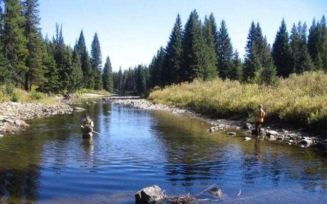
8 Fish Collection Permit Summary Report BC MOE Permit #CB using an Analite NEP160 turbidity meter. These measurements were also taken mid-channel at mid-water depth. 2.3 FISH RESOURCE INVENTORY All sites were sampled by backpack electrofishing in September The fish resource inventory was limited by a timing restriction as defined by the BC Permit Authorization Bureau (2007). The BC fish collection permit stipulated that after September 15, no electrofishing was to be conducted in any watercourses in the Study Area that are known to contain bull trout (Salvelinus confluentus). Therefore, as per the requirement of the permit, the fish resource inventories were conducted prior to September 15, To minimize disturbance to fish and water quality, fish sampling was conducted before the habitat assessment. Electrofishing was conducted throughout the entire survey with a Smith- Root model LR-24 backpack electrofisher. The electrofishing sampling effort required was based on the length of stream fished and the time considered appropriate for the conditions of the stream. Minimum sample-site length was 100 m or 10 times the wetted stream channel width, whichever was greater. All habitat types within the site were sampled. If the habitat was uniform, the sample-site length was increased. Electrofisher settings were adjusted to the stream conditions to sample effectively and minimize injury and mortality. All fish sampling data were recorded on BC fish collection forms (Resources Inventory Committee 1999b). All fish captured were identified to species level and fork length and weight were recorded. The electrofisher settings and duration of effort (in seconds) also were recorded. North/South Consultants Inc. Page 5


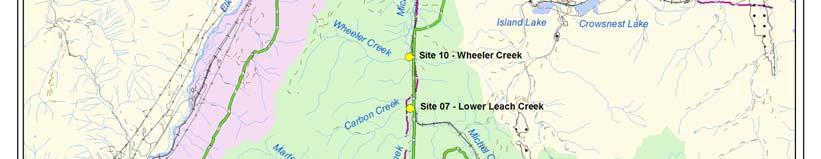

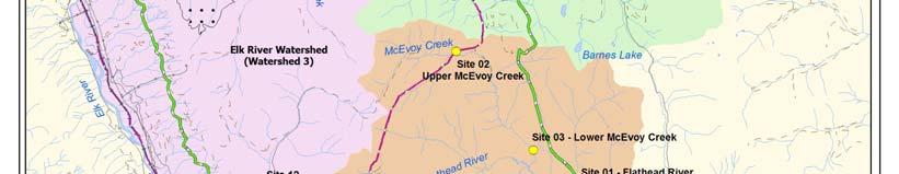


9 Fish Collection Permit Summary Report BC MOE Permit #CB Figure 1-2 Mist Mountain Study Area and sampling sites North/South Consultants Inc. Page 6
10 Fish Collection Permit Summary Report BC MOE Permit #CB RESULTS Appendix A summarizes fisheries habitat, inventory results, and provides site photodocumentation for each site fished under the BC MOE Fish Collection Permit # CB NOTES All fish captured during this study appeared unharmed by electrofishing methods; All fish inventory information was entered into the BC Field Data Information System (FDIS) database and was submitted to BC MOE; The SARA permit number issued for the Flathead River watershed was SECT 07 SCI REFERENCES Forest Practices Code of British Columbia Fish-stream identification guidebook, 2 nd ed. BC Environment and BC Ministry of Forests. 70p. Permit Authorization Service Bureau Permit and Authorization Service Bureau, Ministry of Water, Land and Air Protection. British Columbia. Resources Inventory Committee. 1999a. Reconnaissance (1:20 000) Fish and Fish Habitat Inventory Site Card Field Guide. Prepared by BC Fisheries Information Services Branch for the Resources Inventory Committee. Victoria, British Columbia. 42p. Resources Inventory Committee. 1999b. Reconnaissance (1:20 000) Fish and Fish Habitat Inventory Fish Collection Form Field Guide. Prepared by BC Fisheries Information Services Branch for the Resources Inventory Committee. Victoria, British Columbia. 30p. Resources Inventory Committee Reconnaissance (1:20 000) Fish and Fish Habitat Inventory Standards and Procedures. Prepared by BC Fisheries Information Services Branch for the Resources Inventory Committee. Victoria, British Columbia. 170p. North/South Consultants Inc. Page 7
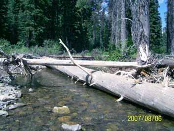
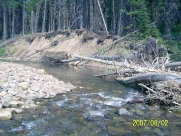
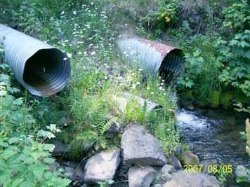
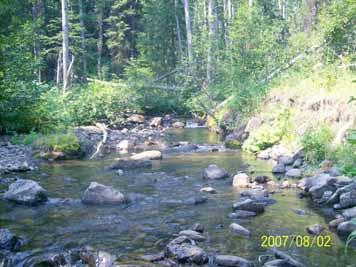
11 Fish Collection Permit Summary Report BC MOE Permit #CB APPENDIX A FISH SURVEY SUMMARY SHEET North/South Consultants Inc. Page 8


12


13


14


15


16


17


18


19


20


21


22


23


24
McNab Creek Spawning/Rearing Channel Monitoring Project 2006 Annual Report - Final
 McNab Creek Spawning/Rearing Channel Monitoring Project 2006 Annual Report - Final August 2006 Prepared for: Howe Sound Pulp and Paper Limited Partnership Port Mellon, BC MCNAB CREEK SPAWNING/REARING CHANNEL
APPENDIX 8. NORTHERN GROUND ELECTRODE LINE WATERCOURSE CROSSING ASSESSMENT BOOKLETS
 APPENDIX 8. NORTHERN GROUND ELECTRODE LINE WATERCOURSE CROSSING ASSESSMENT BOOKLETS Aquatic Environment November 2011 Bipole III Transmission Project Construction Camp CC1 Location Datum: NAD 83 UTM: Zone:
Prepared for: Millennium EMS Solutions Ltd. Prepared by: Pisces Environmental Consulting Services Ltd. Red Deer, AB
 TURBIDITY MONITORING AND FISH CAPTURE AND RELEASE OPERATIONS FOR THE DX CULVERT SOLIDS REMOVAL PROJECT ON APETOWUN CREEK LOCATED IN NE 23-53-24W5M, NORTHEAST OF HINTON, ALBERTA Prepared for: Prepared by:
Fish Passage Culvert Inspection (FPCI)
") Fish Passage Culvert Inspection (FPCI) Creighton Creek (CR) Watershed FIA Project Number SOTSA 9153004 Prepared for: Tolko Industries Ltd., Okanagan Regional Woodlands Prepared by: Michele Trumbley, RPBio
Fish Passage Culvert Inspection (FPCI) Creighton Creek (CR) Watershed FIA Project Number SOTSA 9153004 Prepared for: Tolko Industries Ltd., Okanagan Regional Woodlands Prepared by: Michele Trumbley, RPBio
STREAM Re-Sample for Canfor CMP Audit. Anzac River Watershed. (modified by Kerry Deschamps to include only sites 5, 7,10)
") STREAM Re-Sample for Canfor CMP Audit Anzac River Watershed (modified by Kerry eschamps to include only sites 5, 7,10) Prepared for: Canadian Forest Products Ltd. Prince George ivision 5162 Northwood Pulp
STREAM Re-Sample for Canfor CMP Audit Anzac River Watershed (modified by Kerry eschamps to include only sites 5, 7,10) Prepared for: Canadian Forest Products Ltd. Prince George ivision 5162 Northwood Pulp
Reconnaissance (1:20 000) Fish and Fish Habitat Inventory: Follow-up Sampling (Stream) Standards
 Fish and Fish Habitat Inventory: Follow-up Sampling (Stream) Standards") Reconnaissance (1:20 000) Fish and Fish Habitat Inventory: Follow-up Sampling (Stream) Standards Prepared by Ministry of Environment Ecosystems Branch for the Resources Inventory Committee April, 2006
Reconnaissance (1:20 000) Fish and Fish Habitat Inventory: Follow-up Sampling (Stream) Standards Prepared by Ministry of Environment Ecosystems Branch for the Resources Inventory Committee April, 2006
Prepared for: Millennium EMS Solutions Ltd. Prepared by: Pisces Environmental Consulting Services Ltd. Red Deer, AB
 TURBIDITY MONITORING AND FISH CAPTURE AND RELEASE OPERATIONS FOR SEDIMENT TRAP MAINTENANCE ASSOCIATED WITH OBED MOUNTAIN MINE SOLIDS RECOVERY PROJECT ON APETOWUN CREEK, NORTHEAST OF HINTON, ALBERTA Prepared
Keeyask Infrastructure Project
 Keeyask Infrastructure Project Terrestrial and Aquatic Monitoring Plan Annual Report 2014-2015 December 2015 KEEYASK INFRASTRUCTURE PROJECT TERRESTRIAL AND AQUATIC MONITORING PLAN Water Quality: Annual
Assessing Fish Passage at Culverts the method, its metrics and preliminary findings from over 4,000 assessments.
 Assessing Fish Passage at Culverts the method, its metrics and preliminary findings from over 4,000 assessments. Richard Thompson, Ministry of Environment, Richard.Thompson@gov.bc.ca ABSTRACT There has
Rascal Goose. Reach 1. Rascal Goose. Reach 2. å å å. Main Goose Pit. Stream Reach 3. Main Goose Pit. Stream Reach 7
 434000 March 16 2014 434200 434400 ± 434600 434800 435000 Goose Lake 7269800 WRSA B 7269800 7270000 433800 GIS # BAC-06-180a 7270000 PROJECT # 0234411-0005 Rascal Goose Reach 1 Main Goose Pit Stream Reach
Meacham Creek Restoration Project
 Meacham Creek Restoration Project Meacham Creek Restoration Project Umatilla National Forest Walla Walla Ranger District Michael Rassbach, District Ranger Public Scoping Document Proposal Summary The Walla
Developing a multi-metric habitat index for wadeable streams in Illinois (T-25-P-001).
.") T E C H N I C A L R E P O R T Developing a multi-metric habitat index for wadeable streams in Illinois (T-25-P-001). Annual Segment Report to the Illinois Department of Natural Resources. Laura L. Sass,
T E C H N I C A L R E P O R T Developing a multi-metric habitat index for wadeable streams in Illinois (T-25-P-001). Annual Segment Report to the Illinois Department of Natural Resources. Laura L. Sass,
Appendix 2 Screening of Keewatinoow Construction Camp Waste Water Effluent Discharge to Creek Fourteen
 Appendix 2 Screening of Keewatinoow Construction Camp Waste Water Effluent Discharge to Creek Fourteen Prepared by: North/South Consultants Inc. July 19, 2011 Introduction The following provides a screening
Developing a multi-metric habitat index for wadeable streams in Illinois (T-25-P-001).
.") T E C H N I C A L R E P O R T Developing a multi-metric habitat index for wadeable streams in Illinois (T-25-P-001). Annual Segment Report to the Illinois Department of Natural Resources. Leon C. Hinz
T E C H N I C A L R E P O R T Developing a multi-metric habitat index for wadeable streams in Illinois (T-25-P-001). Annual Segment Report to the Illinois Department of Natural Resources. Leon C. Hinz
Keeyask Infrastructure Project
 Keeyask Infrastructure Project Terrestrial and Aquatic Monitoring Plan Annual Report 2013-2014 December 2014 KEEYASK INFRASTRUCTURE PROJECT TERRESTRIAL AND AQUATIC MONITORING PLAN Water Quality: Annual
SUMMARY OF INDIAN MILL CREEK WATERSHED ASSESSMENT KENT, MICHIGAN
 SUMMARY OF INDIAN MILL CREEK WATERSHED ASSESSMENT KENT, MICHIGAN INTRODUCTION BY: MARY SIEVERT, STUDENT ASSISTANT AND JANICE TOMPKINS, SENIOR WATER QUALITY ANALYST FIELD OPERATION SECTION WATER DIVISION
Prepared for: Millennium EMS Solutions Ltd. Prepared by: Pisces Environmental Consulting Services Ltd. Red Deer, AB
 TURBIDITY MONITORING AND FISH CAPTURE AND RELEASE OPERATIONS FOR FISH BARRIER REMOVAL, CHANNEL RESTORATION, AND BANK ARMOURING PROJECTS ON APETOWUN CREEK LOCATED IN NE 23-53-24 W5M AND SW 25-53-24 W5M,
Environmental Management Plan for Restoring Fish Passage to the Stream Crossing At 12.8 km on the Chuchinka - Crocker FSR
 Environmental Management Plan for Restoring Fish Passage to the Stream Crossing At 12.8 km on the Chuchinka - Crocker FSR Prepared for: Canadian Forest Products Ltd. Prince George Woodlands Division 5162
Fish Habitat Design, Operation and Reclamation Workbook and Worksheets for Placer Mining in the Yukon Territory
 Fish Habitat Design, Operation and Reclamation Workbook and Worksheets for Placer Mining in the Yukon Territory Version 1.0 April 2008 This document is available from the Yukon Placer Secretariat, Yukon
BELGIE CREEK WATERSHED
 BELGIE CREEK WATERSHED Reconnaissance Channel Assessment and Summary Overview Assessment Prepared for: Weyerhaeuser Company Limited Princeton, BC Submitted by: Integrated ProAction Corp. 1425 Hugh Allan
Benthic Invertebrate Biomonitoring Program for the Obed Mountain Mine
 Submitted to: November, 2011 Prepared by: Pisces Environmental Consulting Services Ltd. 25J 37337 Burnt Lake Trail, Red Deer County, Alberta T4S 2K5 --this page left blank for printing purposes-- Table
(Updated February, 2011)
") Terms and Conditions For Changes In And About A Stream Specified By Habitat Officer, West Coast Region (Vancouver Island & Gulf Islands) (Updated February, 2011) Section 42 (1) of the Water Regulation
Terms and Conditions For Changes In And About A Stream Specified By Habitat Officer, West Coast Region (Vancouver Island & Gulf Islands) (Updated February, 2011) Section 42 (1) of the Water Regulation
INTERMEDIATE BMI ASSESSMENT TIER 2 FIELD SHEET
 INTERMEDIATE BMI ASSESSMENT TIER 2 FIELD SHEET PHYSICAL PARAMETERS ASSESSMENT FIELD SHEET ALL TIERS NAME: DATE: TIME: STREAM OR RIVER NAME: WATERSHED NAME: TOWN: WEATHER PRESENT PAST 48 HOURS SITE DESCRIPTION
Fisheries and Aquatic Habitat Monitoring and Follow-up Program Annual Report: Dec 22, 2015 to Dec 31, 2016
 Fisheries and Aquatic Habitat and Follow-up Annual Report: Dec 22, 2015 to Dec 31, 2016 Site C Clean Energy Project March 1, 2017 Table of Contents 1.0 Introduction... 3 1.1 Background... 3 1.2 Summary...
Special Investigation
 Fish Passage at Stream Crossings Special Investigation FPB/SIR/25 January 2009 Table of Contents Executive Summary... 1 Introduction... 2 Background... 2 Objectives... 4 Methodology... 5 Selection of
Reasons for Ministers Decision
 In the matter of the Environmental Assessment Act S.B.C. 2002, c. 43 (Act) and In the matter of an Application for an Environmental Assessment Certificate (Application) by Teck Coal Limited (Proponent)
Fraser River Water Quality
 Richmond Environmental Project Guidebook Fraser River Water Quality Why You Should Care About This Issue The Fraser River is the largest river in British Columbia. The health of the Fraser River is important
Fish Habitat Design, Operation and Reclamation Workbook and Worksheets for Placer Mining in the Yukon Territory
 Fish Habitat Design, Operation and Reclamation Workbook and Worksheets for Placer Mining in the Yukon Territory Version 1.3 November 2010 This document is available from: Yukon Placer Secretariat, 206B
Introduction and Background
 100 Extension Note January 11 Small Stream Riparian Retention: the Prince George Small Streams Project John Rex and Dave Maloney British Columbia Ministry of Forests and Range Erland MacIsaac and Herb
2012 Mill Creek Watershed Habitat Assessment Level 3 Project Study Plan Results
 2012 Mill Creek Watershed Habitat Assessment Level 3 Project Study Plan Results Cranberry Run This project study plan was financed through a Sub-grant from the Ohio EPA with funds from the State of Ohio.
A landscape perspective of stream food webs: Exploring cumulative effects and defining biotic thresholds
 A landscape perspective of stream food webs: Exploring cumulative effects and defining biotic thresholds Objectives To better understand how stream food webs are embedded in their landscapes To quantify
BUREAU OF CLEAN WATER CAUSE AND EFFECT SURVEY PROTOCOL DECEMBER 2015
 BUREAU OF CLEAN WATER CAUSE AND EFFECT SURVEY PROTOCOL DECEMBER 2015 PROTOCOL FOR CONDUCTING CAUSE AND EFFECT SURVEYS Cause and effect surveys are designed to investigate possible relationships between
Application for Paragraph 35(2)(b) Fisheries Act Authorization for Workforce Accommodation Centre Revision 1, November 2015
(b) Fisheries Act Authorization for Workforce Accommodation Centre Revision 1, November 2015") Application for Paragraph 35(2)(b) Fisheries Act Authorization for Workforce Accommodation Centre The copyright of this document is vested in LNG Canada Development Inc. All rights reserved. 8. FISH HABITAT
Application for Paragraph 35(2)(b) Fisheries Act Authorization for Workforce Accommodation Centre The copyright of this document is vested in LNG Canada Development Inc. All rights reserved. 8. FISH HABITAT
Environmental Assessment Form Part 1 Resource Identification Enclosure C Description of Aquatic Habitat
 Environmental Assessment Form Part 1 Resource Identification Enclosure C Description of Aquatic Habitat 8. Provide a written narrative, identified and labeled as Enclosure C Description of Aquatic Habitat,
Prince George Small Streams Project Present
 Prince George Small Streams Project 1999 Present Introduction The management of small-stream riparian zones is particularly important because small streams are a prominent feature in watersheds. Their
HAYES CREEK WATERSHED. Reconnaissance Channel Assessment and Summary Overview Assessment
 HAYES CREEK WATERSHED Reconnaissance Channel Assessment and Summary Overview Assessment Prepared for: Weyerhaeuser Company Limited Princeton, BC Submitted by: Integrated Woods Services Ltd. 1425 Hugh Allan
Cutblock (Lot 450) Inspection Powell River. - Island TimberLands-
 Inspection Powell River. - Island TimberLands-") Cutblock 883256 (Lot 450) Inspection Powell River - Island TimberLands- Prepared By: Shawn Hamilton and Associates 430 Odyssey Lane Victoria, BC V9E 2J2 Cutblock 883256 Inspection Inspection # IN-1501
Cutblock 883256 (Lot 450) Inspection Powell River - Island TimberLands- Prepared By: Shawn Hamilton and Associates 430 Odyssey Lane Victoria, BC V9E 2J2 Cutblock 883256 Inspection Inspection # IN-1501
GENERAL SPECIFICATION FOR ENVIRONMENTAL PROTECTION FOR CONSTRUCTION IN WATERBODIES AND ON WATERBODY BANKS
 ONTARIO PROVINCIAL STANDARD SPECIFICATION METRIC OPSS.PROV 182 NOVEMBER 2012 GENERAL SPECIFICATION FOR ENVIRONMENTAL PROTECTION FOR CONSTRUCTION IN WATERBODIES AND ON WATERBODY BANKS TABLE OF CONTENTS
25 Exhibit 01 Parameters to be measured for each Tier 2, 3, 4 survey
 EFFECTIVE DATE: 10/22/2001 Page 1 of 9 25 Exhibit 01 Parameters to be measured for each Tier 2, 3, 4 survey Parameter Tier 2 Tier 3 Tier 4 Channel At least one time per channel type. Increase frequency
STREAM REPORT. LICENCE A15429 CP 200 BLOCKS 003 and 004
 STREAM REPORT LICENCE A15429 CP 200 LOCKS 003 and 004 Prepared for: Carrier Lumber Ltd. 4722 Continental Way, Prince George,.C. V2N 5S5 Telephone 250-563-9271 Prepared by: W Consulting Services Ltd. #1A-1750
FORM 1 Riparian Areas Regulation - Qualified Environmental Professional - Assessment Report
 Riparian Areas Regulation: Assessment Report Please refer to submission instructions and assessment report guidelines when completing this report. Date 2006-07-17 I. Primary QEP Information First Name
Turbidity Changes During Culvert to Bridge Upgrades at Carmen Creek, Idaho
 Turbidity Changes During Culvert to Bridge Upgrades at Carmen Creek, Idaho Randy B. Foltz 1, Breann Westfall 2, and Ben Kopyscianski 3 Abstract: Carmen Creek, a tributary to the Salmon River in Idaho,
Integrated Flood Management Plan for the Lower Cowichan Valley, British Columbia
 Integrated Flood Management Plan for the Lower Cowichan Valley, British Columbia Tamsin Lyle, M.Eng. M.R.M., P.Eng. 1 Vanessa O Connor, M.Eng., EIT. 1 Dave McLean, Ph.D., P.Eng. 1 Kate Miller, M.S. 2 1
RIPARIAN AREAS REGULATION
 Definitions and interpretation RIPARIAN AREAS REGULATION 1 (1) In this regulation: Act means the Fish Protection Act; active floodplain means an area of land that supports floodplain plant species and
GUIDE TO THE CODE OF PRACTICE FOR WATERCOURSE CROSSINGS, INCLUDING GUIDELINES FOR COMPLYING WITH THE CODE OF PRACTICE
 GUIDE TO THE CODE OF PRACTICE FOR WATERCOURSE CROSSINGS, INCLUDING GUIDELINES FOR COMPLYING WITH THE CODE OF PRACTICE May 2000 Revised April 2001 TABLE OF CONTENTS Page 1. Introduction 3 2. Topics in the
FIA PROJECT # LOUIS CREEK FISH PASSAGE ASSESSMENTS. Project number: 4243 Revision: 1 January 31, Prepared for:
 Project number: 4243 Revision: 1 January 31, 2010 FIA PROJECT #9028007 LOUIS CREEK FISH PASSAGE ASSESSMENTS Prepared for: Tolko Industries Ltd Heffley Creek Division Heffley Woodlands 6001 Yellowhead Highway
Elko Project Water Use Plan. Revised for Acceptance by the Comptroller of Water Rights
 Elko Project Water Use Plan Revised for Acceptance by the Comptroller of Water Rights 7 April 2005 B Elko Project Water Use Plan Revised for Acceptance by the Comptroller of Water Rights Elko Project
National. Park Service Mr. Chris. and Flathead PO Box 638 Kalispell, MT 59903
 QUARTZ CREEK FISH EXCLUSION BARRIER PROJECT CONCEPTUAL DESIGN ALTERNATIVES REPORT Submitted To: National Park Service Mr. Chris Downs, Fishery Biologist Science Center, Glacier National Park West Glacier,
Case Study 5. Willow Creek Concrete Plank Ford
 Appendix A Case Study Case Study. Willow Creek Concrete Plank Ford Location Northeastern California. Plumas National Forest. Willow Creek. miles northwest of Portola, CA, on Spur Road 23N97Y off Forest
Proponent Action Plan for The Culvert Replacement Located at m on the Kluskus FSR In the Plateau Operating Area
 Proponent Action Plan for The Culvert Replacement Located at 118 + 850m on the Kluskus FSR In the Plateau Operating Area Prepared for: Canadian Forest Products Ltd. Prince George Division 5162 Northwood
Forest & Range Evaluation Program
 Forest & Range Evaluation Program Riparian Management Effectiveness & the Fish Value Post-Harvest Assessments of Riparian, Stream, & Fish Habitat Conditions Peter J. Tschaplinski Ministry of Environment
SECTION D RIPARIAN FUNCTION
 Riparian Function Creek WAU SECTION D RIPARIAN FUNCTION INTRODUCTION Mendocino Redwood Company conducted an assessment of riparian function in the Creek Watershed Analysis Unit (WAU) during the summer
General Disclaimer. Disclaimer of Liability
 General Disclaimer The use of trade, firm, or corporation names in this publication is for the information and convenience of the reader. Such use does not constitute an official endorsement or approval
Stream Crossing Reconstruction on the Bog Dam Loop Road (FR15) Scoping Notice. Androscoggin Ranger District
 Scoping Notice. Androscoggin Ranger District") United States Department of Agriculture Forest Service White Mountain National Forest Stream Crossing Reconstruction on the Bog Dam Loop Road (FR15) Scoping Notice Androscoggin Ranger District Androscoggin
United States Department of Agriculture Forest Service White Mountain National Forest Stream Crossing Reconstruction on the Bog Dam Loop Road (FR15) Scoping Notice Androscoggin Ranger District Androscoggin
COTTON CREEK CULVERT REPLACMENT
 COTTON CREEK CULVERT REPLACMENT Integrating Mobility with Environmental Innovation Located along a scenic section of Highway 3/95 in British Columbia, Moyie Bluffs, a 6.5 km stretch of inland highway had
NCS Design Approach. Biology/Ecology Primer. Presented by: Jack Imhof, National Biologist Trout Unlimited Canada
 NCS Design Approach Biology/Ecology Primer Presented by: Jack Imhof, National Biologist Trout Unlimited Canada Biology/Ecology Key biological principles that are applied Need to speak the same language
Wetted Perimeter Assessment Shoal Harbour River Shoal Harbour, Clarenville Newfoundland. Submitted by: Submitted to: January 8, 2003 TF05205
 Shoal Harbour, Clarenville Newfoundland Submitted by: James H. McCarthy AMEC Earth & Environmental Limited 95 Bonaventure Ave. St. John s, NL A1C 5R6 Submitted to: Mr. Kirk Peddle SGE-Acres 45 Marine Drive
The F.O.R.C.E. The Future Of Redwood Creek Environment
 The F.O.R.C.E. The Future Of Redwood Creek Environment Robert Andersen Katelyn Csatari Achyuth Madabhushi Julie Swanson Overview Mission Statement Watershed Characterization Land and Water Use History
LAND 2 Multiple Use Opportunity Assessment
 LAND 2 MULTIPLE USE OPPORTUNITY ASSESSMENT This study provides information to address the study objectives described in the LAND 2, Multiple Use Opportunity Assessment study plan, developed for the relicensing
The District of Maple Ridge Stream Protection Regulation Guidelines. Watermark Technologies Canada
 The District of Maple Ridge Stream Protection Regulation Guidelines Watermark Technologies Canada Outline 1. Overview On Maple Ridge GPS Stream Mapping & Inventory Information System 2. Information System
Subject: Keewatinoow Construction Camp Waste Water: Screening of Sewage Effluent Discharge. North/South Consultants Inc.
 KEEWATINOOW CAMP MEMORANDUM Subject: Keewatinoow Construction Camp Waste Water: Screening of Sewage Effluent Discharge. To: From: Pat McGarry Manitoba Hydro Kurt Mazur North/South Consultants Inc. Date:
Ambient Water Quality Objectives For The Tributaries To Okanagan Lake Near Kelowna
 Water Quality Ambient Water Quality Objectives For The Tributaries To Okanagan Lake Near Kelowna Overview Report Water Management Branch Environment And Resource Division Ministry Of Environment, Lands
Lessons Learned from the Jocko River Demonstration Project
 Lessons Learned from the Jocko River Demonstration Project Applied Adaptive Management Matt Daniels, P.E. Presentation Objectives Provide a brief overview of the project context. Describe the monitoring
Prepared for: Pope & Talbot Ltd. Arrow Lakes Timber Division Box 2000 Nakusp, BC V0G 1R0 Phone: (250)
") Reconnaissance (1:20,000) Fish and Fish Habitat Inventory Follow-up Sampling on TFL 23: Snow Creek Watershed (WSC 300-690200-07600) Mosquito Creek Watershed (WSC 300-679000) Upper Halfway River Watershed
Reconnaissance (1:20,000) Fish and Fish Habitat Inventory Follow-up Sampling on TFL 23: Snow Creek Watershed (WSC 300-690200-07600) Mosquito Creek Watershed (WSC 300-679000) Upper Halfway River Watershed
Effects of the 1988 Wildfires on Stream Systems of Yellowstone National Park
 University of Wyoming National Park Service Research Center Annual Report Volume 16 16th Annual Report, 1992 Article 32 111992 Effects of the 1988 Wildfires on Stream Systems of Yellowstone National Park
Fish Habitat Design, Operation and Reclamation Workbook and Worksheets for Placer Mining in the Yukon Territory
 Fish Habitat Design, Operation and Reclamation Workbook and Worksheets for Placer Mining in the Yukon Territory Fish Habitat Design, Operation and Reclamation Workbook and Worksheets for Placer Mining
Mill Creek Restoration in Lower Merion Township. PH (610) ; FAX (610) ;
 ; FAX (610) ;") Mill Creek Restoration in Lower Merion Township Vincent L. Sortman 1 and Robert M. Lambert 2 1 Biohabitats, Inc., 15 W. Aylesbury Road, Timonium, MD 21093; PH (410) 337-3659; FAX (410) 583-5678; email:
Mill Creek Restoration in Lower Merion Township Vincent L. Sortman 1 and Robert M. Lambert 2 1 Biohabitats, Inc., 15 W. Aylesbury Road, Timonium, MD 21093; PH (410) 337-3659; FAX (410) 583-5678; email:
Carp Creek 2013 Summary Report
 Monitoring Activity in the Carp River Watershed In 2012, Mississippi Valley Conservation Authority (MVCA) worked with Friends of the Carp River (FCR) on a preliminary assessment of the Carp River. This
CITY OF NEW WESTMINSTER. Bylaw No. 7033, 2005 RIPARIAN AREAS PROTECTION BYLAW
 CITY OF NEW WESTMINSTER Bylaw No. 7033, 2005 RIPARIAN AREAS PROTECTION BYLAW WHEREAS the City may preserve, protect, restore and enhance the natural environment near streams that support fish habitat from
Towards. Sustainable Forest Management
 SAUNDERS CREEK WATERSHED Towards Sustainable Forest Management Prepared for Gold River Operations March 2004 Prepared for: Reporting by: Shawn Hamilton and Associates Saunders Creek Sustainable Forest
DEVELOPING A WATERSHED IMPROVEMENT PLAN TO MEET MULTIPLE COMMUNITY OBJECTIVES IN GAINESVILLE AND HALL COUNTY, GEORGIA
 DEVELOPING A WATERSHED IMPROVEMENT PLAN TO MEET MULTIPLE COMMUNITY OBJECTIVES IN GAINESVILLE AND HALL COUNTY, GEORGIA Chrissy, Thom 1, David Dockery 2, Kevin McInturff 3, Betsy Massie 1, and Lauren Murphy
Appendix E: Methods of Collecting Macroinvertebrates in Streams
 Quality Assurance Project Plan DuPage-Salt Creek Assessment Revision 1.0 July 1, 2006 Appendix E Appendix E: Methods of Collecting Macroinvertebrates in Streams 1 Methods of Collecting Macroinvertebrates
F7 Stream Reach Summary
 F7 Stream Reach Summary Study Reach: F7, Fraser River - Ranch Creek confluence downstream to Canyon below Strawberry Road. Reach Description: Approximate channel length: 1 ½ miles, approximate channel
THE PROCESS OF NATURAL RESOURCE MANAGEMENT AND THE
 WMAN 175: Introduction to Wildlife and Fisheries Resources THE PROCESS OF NATURAL RESOURCE MANAGEMENT AND THE ROLE OF SCIENCE Petty Notes February 21, 2008 Educational Goal of the Wildlife and Fisheries
PROJECT SCREENING MATRIX: A User s Guide
 Version 2.0 Page 1 of 7 November 9, 2010 PROJECT SCREENING MATRIX: A User s Guide BACKGROUND The Project Screening Matrix (Screening Matrix) is one of several tools that comprise the River Restoration
FORTUNE MINERALS LIMITED NICO DEVELOPER'S ASSESSMENT REPORT INFORMATION REQUEST RESPONSES
 FORTUNE MINERALS LIMITED NICO DEVELOPER'S ASSESSMENT REPORT INFORMATION REQUEST RESPONSES ATTACHMENT A Fish and Fish Habitat Assessment of Watercourses Along the Proposed Nico All-Weather Road December
Ongoing and Completed Studies
 Attachment 2 Ongoing and Completed Studies 2014 Monitoring and Analysis Plan November 2013 Attachment 2 Ongoing and Completed Studies 1 Introduction In 2013, the small interdisciplinary study groups for
WATERCOURSE CROSSINGS HYDROTECHNICAL ASSESSMENT & DESIGN RECOMMENDATIONS Liege Lateral Loop No. 2 Pelican Lake Section
 WATERCOURSE CROSSINGS HYDROTECHNICAL ASSESSMENT & DESIGN RECOMMENDATIONS Liege Lateral Loop No. 2 Pelican Lake Section Note: Sub Vendor supplied data January 28, 2016 Page 1 of 22 LIEGE LATERAL LOOP NO.
DILLARD CREEK COMMUNITY WATERSHED Reconnaissance Channel Assessment and Summary Overview Assessment
 DILLARD CREEK COMMUNITY WATERSHED Reconnaissance Channel Assessment and Summary Overview Assessment Prepared for: Weyerhaeuser Company Limited Princeton, BC Submitted by: Integrated Woods Services Ltd.
Clayton Falls Project Water Use Plan. Aquatic Productivity Monitoring. Reference: CLAMON#1
 Clayton Falls Project Water Use Plan Aquatic Productivity Monitoring Reference: CLAMON#1 Clayton Falls Water Use Planning Aquatic Productivity Monitoring Program Study Period: 26 February 2006 17 September
Temporary Watercourse Crossing: Fords
 Temporary Watercourse Crossing: Fords DRAINAGE CONTROL TECHNIQUE Low Gradient Velocity Control Short Term Steep Gradient Channel Lining Medium-Long Term Outlet Control Soil Treatment Permanent [1] [1]
GENERAL SPECIFICATION FOR ENVIRONMENTAL PROTECTION FOR CONSTRUCTION IN AND AROUND WATERBODIES AND ON WATERBODY BANKS
 ONTARIO PROVINCIAL STANDARD SPECIFICATION METRIC OPSS.PROV 182 APRIL 2017 GENERAL SPECIFICATION FOR ENVIRONMENTAL PROTECTION FOR CONSTRUCTION IN AND AROUND WATERBODIES AND ON WATERBODY BANKS TABLE OF CONTENTS
FOUR BEETLES PROJECT
 FOUR BEETLES PROJECT ALEJANDRO RAMIREZ CALIFORNIA STATE UNIVERSITY, FRESNO 6/7/2016-8/5/2016 CURTIS FAIR (DISTRICT ARCHAEOLOGIST) & JOHN KELLEY (DISTRICT HYDROLOGIST) MENDOCINO NATIONAL FOREST Acknowledgements
7.0 WATER-BASED CONTROL MEASURES
 7.0 WATER-BASED CONTROL MEASURES 7.1 IDENTIFICATION AND DESCRIPTION OF CONTROL MEASURES Table 7-1 lists the water-based options being considered for implementation in the initial screening stage. Descriptions
The Influence of LWD and Tributary Confluences on the Local Grain Size Distributions of the H.J. Andrews Stream Network
 The Influence of LWD and Tributary Confluences on the Local Grain Size Distributions of the H.J. Andrews Stream Network Brent Davis Abstract The influence of Large Woody Debris (LWD) and tributary confluences
404(b)(1) EVALUATION
(1) EVALUATION") 404(b)(1) EVALUATION SECTION 404(b)(1) EVALUATION DETAILED PROJECT REPORT AND ENVIRONMENTAL ASSESSMENT POMEROY SECTION 14 EMERGENCY STREAMBANK PROTECTION PROJECT POMEROY, OH I. INTRODUCTION As required
404(b)(1) EVALUATION SECTION 404(b)(1) EVALUATION DETAILED PROJECT REPORT AND ENVIRONMENTAL ASSESSMENT POMEROY SECTION 14 EMERGENCY STREAMBANK PROTECTION PROJECT POMEROY, OH I. INTRODUCTION As required
Designing roads for fish, floods and foxes
 Designing roads for fish, floods and foxes Calculations 9 Swimming Plunging Flow & Leaping Occupied Velocity Prolonged > Capability Yes Swim in Burst Total Time in Burst Time to > Exhaustion Yes Barrier
Western Strait Drainages. Watershed Summaries DRAINAGES EST WRIA 19 EST
 Page 31 WESTERN STRAIT DRAINAGES EST WRIA 19 WEST EST Snow, Bullman, Jansen & Olsen Creeks Sekiu River Hoko & Little Hoko Rivers Clallam River & Estuary Pysht River & Estuary Green Creek Jim & Joe Creeks
Decision Notice/Finding of No Significant Impact 1
 DECISION NOTICE FINDING OF NO SIGNIFICANT IMPACT BULL RUN CULVERT REPLACEMENTS U.S. FOREST SERVICE WHITMAN RANGER DISTRICT, WALLOWA-WHITMAN NATIONAL FOREST GRANT COUNTY, OREGON TOWNSHIP 9 SOUTH, RANGE
Public Information Centre September 19 th, 2017
 Public Information Centre September 19 th, 2017 WELCOME! Public Information Centre for the Maple Hill Creek Rehabilitation Class Environmental Assessment Please take the time to sign our sign in sheet
Bonsall Creek Watershed Management Plan Gap Analysis
 Bonsall Creek Watershed Management Plan Gap Analysis March 2015 Prepared by Gap Analysis Introduction The Bonsall Creek Watershed Management Plan provides a vision for water use in the watershed, including
S.R. 4007, Section 14B PADEP Environmental Assessment Form. Enclosure C Description of Aquatic Habitat
 S.R. 4007, Section 14B PADEP Environmental Assessment Form Description of Aquatic Habitat Cresheim Creek is the only water resource that exists within the project area. No jurisdictional wetlands were
Terms and Conditions for Water Sustainability Act
 Terms and Conditions for Water Sustainability Act Changes In and About a Stream as specified by Ministry of Forests, Lands, Natural Resource Operations, and Rural Development (FLNRORD) Habitat Officers,
AQUATIC ECOSYSTEM RESTORATION PROJECT
 AQUATIC ECOSYSTEM RESTORATION PROJECT EFFECTS OF THE FLOODS OF 1996 QUARTZ CREEK WILLAMETTE NATIONAL FOREST Submitted by: Dr. Stan Gregory Randy Wildman Department of Fisheries and Wildlife Oregon State
Forest investment Account Watershed Restoration Program. Aquatic Habitat Rehabilitation Prescription. for.
 2003-2004 Forest investment Account Watershed Restoration Program Aquatic Habitat Rehabilitation Prescription for MacIntyre Creek Queen Charlotte Islands Prepared for: Teal Cedar Products Ltd. Sandspit,
Information Requirements Table for Liquid Waste
 Applicant Summary Tracking # Authorization # Applicant / Facility Name Ministry of Environment Prepared by: Title Date The Information Requirements Table (IRT) for Liquid Waste is a tool used by Ministry
Project Goals and Scoping
 Prepared for: Boulder County, Colorado Flood Planning & Preliminary Design Services for South St. Vrain Creek Restoration at Hall Ranch and Scoping May 24, 2016 Meeting with General Public In association
GRAYS HARBOR ESTUARY MANAGEMENT UNIT GRAYS HARBOR ESTUARY
 GRAYS HARBOR ESTUARY MANAGEMENT UNIT GRAYS HARBOR ESTUARY Description: The Grays Harbor Estuary is a bar-built estuary that was formed by the combined processes of sedimentation and erosion caused by both
SAGE CREEK FISH HABITAT ASSESSMENT PROCEDURE (FHAP)
") ABSTRACT The Fish Habitat Assessment Procedure (FHAP) is one component of an integrated watershed restoration project conducted for the B.C. Ministry of Environment, Lands and Parks (MoELP) by Dillon Consulting
ABSTRACT The Fish Habitat Assessment Procedure (FHAP) is one component of an integrated watershed restoration project conducted for the B.C. Ministry of Environment, Lands and Parks (MoELP) by Dillon Consulting
Request for Proposal (RFP) Lower Kings River Fishery Habitat Characterization and Identification of Restoration Opportunities.
 Lower Kings River Fishery Habitat Characterization and Identification of Restoration Opportunities.") Request for Proposal (RFP) Lower Kings River Fishery Habitat Characterization and Identification of Restoration Opportunities August 2017 The Kings River Water Association (KRWA), Kings River Conservation
Request for Proposal (RFP) Lower Kings River Fishery Habitat Characterization and Identification of Restoration Opportunities August 2017 The Kings River Water Association (KRWA), Kings River Conservation