NOTICE OF PREPARATION
|
|
|
- Barnard Hill
- 6 years ago
- Views:
Transcription

1 NOTICE OF PREPARATION Date: October 31, 2014 To: Subject: Lead Agency: Responsible, Trustee and Interested Agencies, Organizations, and Individuals Notice of Preparation of a Draft Environmental Impact Report and Notice of a Public Scoping Meeting for the Pilot Flying J Travel Center Project in Orland City of Orland The City of Orland is proposing to prepare an Environmental Impact Report (EIR) for the Pilot Flying J Travel Center Project (proposed project) and is issuing this Notice of Preparation (NOP) per Section of the California Environmental Quality Act (CEQA) Guidelines. The City is requesting input from the public and your agency on environmental issues associated with development of the proposed project as described in this NOP. As a responsible or trustee agency, your agency may need to use this EIR when considering issuance of a permit or other discretionary approval for the proposed project. Comments received during this public comment period will be used to focus the environmental analysis in the EIR. Pilot Flying J Travel Center Project Overview The project site is located adjacent to Orland in Glenn County (see Figure 1, Project Location). The proposed Pilot Flying J Travel Center is on Glenn County Assessor s Parcel In addition, five other parcels, identified as Glenn County Assessor s Parcel Numbers , , -010, - 011, and -012, are proposed to be annexed into the Orland city limits as a part of this project. The parcels are located to the west of Interstate 5 and north of County Road 13 (Figure 2, Proposed Area of Annexation). County Road 200 and County Road 13 are improved with public utilities including water, wastewater, and power. The proposed project will include a 12,964-square-foot travel center that includes 9 diesel fueling lanes, 12 gasoline fueling lanes, and 2 recreational vehicle fueling lanes along with a convenience store, fast food eatery, drivers lounge and necessary project support and site improvements. Comment Period The 30-day NOP comment period commences on October 31, 2014, and ends on November 29, When submitting comments, please be specific in describing your environmental concerns. In particular, if there are changes to the project you believe the City should take that would reduce the environmental
2 impact of the project or address issues of concern, please include them in your response to this NOP. Please also include contact information so that the City can follow up with questions regarding comments if necessary. Comments must be sent to: Scoping Meeting Scott Friend, AICP, City Planner City of Orland 815 Fourth Street Orland, CA (530) A scoping meeting will be conducted at 6:00 p.m. on Thursday, November 20, 2014, in the Carnegie Center, 912 Third Street in Orland to provide public agencies and other interested parties with the opportunity to learn more about the proposed project and to discuss environmental issues. The scoping meeting will include a presentation of the proposed project and a summary of the environmental issues to be analyzed in the EIR. Comments provided during the scoping meeting will assist the City in scoping the potential environmental effects of the project to be addressed by the EIR. Pilot Flying J Travel Center Project Description Project Location and Setting Regionally, the project site is located adjacent to Orland in Glenn County (see Figure 1, Project Location). The annexation area is located on parcels to the west of Interstate 5 and north of County Road 13 (Figure 2, Proposed Area of Annexation). The associated Assessor s Parcels are shown below in Table 1, Area of Annexation General Plan Designations. The Pilot Flying J Travel Center is proposed on Assessor s Parcel Number There are no buildings or other visible improvements on the property. The property is designated as Commercial in the City of Orland General Plan and Highway and Visitor Service Commercial in the Glenn County General Plan. Surrounding land uses neighboring the Pilot Flying J Travel Center site and the Annexation Area include agriculture, commercial, and residential uses. Directly to the west of the site are agricultural land and two single-family homes. The area north of the project site is the Neville Road/Interstate 5 interchange; across Newville Road are commercial uses (fast-food and sit-down restaurants). Northwest of the site, also across Newville Road, is a mobile home park. East of the site is Interstate 5. South of the site is vacant land, a single-family home, and pastureland. Those areas north of the project site are within the Orland city limits and have the Orland General Plan land use designation of Commercial for the commercial areas and High Density Residential for the mobile home park. The lands south of the project site are in Glenn County and have the Glenn County General Plan land use designation of Service Commercial.
3 Project Description Project Components The proposed project includes two components: (1) the annexation by the City of Orland of a total of six parcels, and (2) the development of a proposed Pilot Flying J Travel Center. While all of the six parcels would be annexed by the City, for clarification purposes the Annexation Area analyzed in this EIR consists of five parcels totaling approximately acres which are analyzed at a program-level. The 9.2-acre Pilot Flying J Travel Center site is analyzed separately in this EIR at the project-level. Other than development of the Pilot Flying J Travel Center on the 9.2-acre site, all uses in the Annexation Area are to remain as currently existing; no development of these areas has been proposed as a part of this project. However, in order to ascertain the potential for environmental impact resulting from annexation of the Annexation Area, a development potential for each individual parcel has been assumed based on the application of intensity standards identified in the Orland General Plan Land Use Element. Annexation / Annexation Elements As discussed above, the annexation to the city would include six parcels (APNs (Pilot Flying J Travel Center location), , , , , and ). The total project area is acres. However, as stated previously, the 9.2-acre Pilot Flying J Travel Center site is analyzed separately in this EIR at a project level. This is done because the Pilot Flying J Travel Center site has specific development proposed, while the remaining parcels do not. Therefore, for discussions referring to project annexations in this EIR, the Annexation Area is composed of five parcels and a total of acres for this analysis. Table 1 identifies the current uses and the General Plan land use designations for Glenn County and the City of Orland for the Annexation Area properties as well as the Pilot Flying J Travel Center site. Table 1 also shows the assumed use of each of the annexation parcels. These assumed new uses have been determined by considering the existing use and whether that use is consistent with the Orland General Plan for the Commercial land use designation. Based on this, for environmental analysis purposes, it is assumed that the Annexation Area has the potential to result in 235,200 square feet of new commercial uses. Figure 1 provides an illustration of the proposed Annexation Area.
4 APN Existing Use Acreage Single-family home TABLE 1 AREA OF ANNEXATION GENERAL PLAN DESIGNATIONS General Plan Land Use Designation Glenn County City of Orland Annexation Area 0.59 Service Commercial Commercial Assumed Use 1 15,400 sq. ft. commercial Gas Station 0.44 Suburban High Density Residential Residential 8.8 dwelling units Eagles Hall 0.40 Service Commercial Commercial Existing use to remain Single-family 13,050 sq. ft Service Commercial Commercial home commercial Agriculture, Suburban 222,150 sq. ft. single-family 8.50 Commercial Residential commercial home Pilot/Flying J Travel Center Project Vacant land Pilot/Flying J Travel 9.20 Highway and Visitor Center 2 (7.5 and Commercial 1.7) 2 Service Commercial 44,400 sq. ft. commercial 2 1 New assumed use building size is based on a maximum building coverage of 60 percent as defined by the Orland General Plan for the Commercial land use designation. 2 This parcel will be split, 7.5 acres to the Pilot Flying J Travel Center project and a 1.7-acre remainder. This parcel is analyzed as a part of the Pilot Flying J Travel Center project in this EIR. Pilot Flying J Travel Center Project Location and Land Use Designations The proposed Pilot Flying J Travel Center Project is located at the southwest quadrant of Interstate 5 (I-5) and Newville Road. The triangular-shaped site is bordered to the northeast by Newville Road/County Road 200 and the southbound I-5 on-ramp, to the west by County Road HH, and to the south by County Road 13. The property is located in Section 21, Township 22 North, Range 3 West, MDM, County of Glenn, California. The project site is currently within the jurisdiction of Glenn County; however, the project applicant proposes annexation of the site by the City of Orland. The proposed project includes the approval of a tentative parcel map to divide the 9.2-acre site (APN ) into two parcels (see Figure 3, Proposed Tentative Parcel Map). Parcel A would be 7.5 acres and the location of the Pilot Flying J Travel Center. Parcel B would be 1.7 acres in size. All proposed improvements for the project are located on Parcel A. While no development requests have been made regarding Parcel B, as a part of this environmental analysis Parcel B is assumed to be developed as 44,400 square feet of commercial uses. The Pilot Flying J Travel Center project site is within the Orland General Plan Sphere of Influence (SOI) and Planning Area. The project site is currently designated in the Orland General Plan as Commercial (C). The Glenn County General Plan land use designation for the project site is Highway and Visitor
5 Service Commercial. Because the project is outside of the Orland city limits, the City does not currently have zoning for the site. Glenn County zoning for the site is Highway and Visitor Commercial (HVC). The proposed project includes a request to the City of Orland to prezone the site as Commercial Service Highway (C-H). For the following discussion, semi trucks and heavy delivery trucks that would normally use diesel fueling stations are referred to as trucks. Automobile and pickup trucks are referred to as autos. Operational Characteristics The Pilot Flying J Travel Center site is 9.2 acres in size and is currently vacant land. This land was used for agricultural purposes in the past but is no longer used for that purpose. The project proposes the development of an automobile/truck fueling station and a 12,964-square-foot building including a fastfood restaurant, retail convenience store, deli, and travelers lounge (See Figure 4, Proposed Site Plan Pilot Flying J Travel Center Parcel). The project will be open 24 hours a day seven days a week and anticipates employing 75 persons. The project anticipates serving 400 trucks per day and approximately 400 autos. Project amenities are as follows: Fueling facilities offering 10 diesel lanes (includes diesel, diesel exhaust fluid (DEF), and biodiesel), 12 gas lanes, and 2 recreational vehicle lanes CAT Certified Scales 100-foot-tall pole sign for interstate traffic 38-foot-tall goalpost sign along Newville Road 62 truck parking spaces 61 automobile parking spaces Bio shed building 21.9-foot-tall, 12,964-square-foot commercial building that will include the following: o Drivers lounge, game room, and pay phones o Restroom facilities, seven showers for rent, and public laundry o 2,585-square-foot retail convenience store o 1,215-square-foot deli o 2,605-square-foot fast food restaurant (1,140 square feet of dining area and 1,465-squarefoot kitchen) o Fast food kiosk Project Details The proposed project will include the following actions: 1. Certification of the Environmental Impact Report 2. Prezoning for annexation of the project site 3. Tentative Map approval 4. Use Permit approval 5. Site Plan review 6. Development Agreement approval 7. Annexation approval 8. Issuance of grading, encroachment, and building permits
6 Anticipated Significant Environmental Impacts The City has determined that the proposed project will require preparation of an EIR. As permitted by CEQA Section 15060(d), the City will not prepare an Initial Study. For the portion of the site on which a development application has been presented, the City will prepare a project EIR as defined in Section of the CEQA Guidelines. The City anticipates the following significant environmental impacts: Air Quality: Development of a fueling center will result in trucks and autos traveling to and from the proposed project. While the project site is adjacent to Interstate 5, project traffic will increase the amount of diesel and other air emissions in the city. The EIR will evaluate the air quality impacts associated with the proposed project. Biological Resources: Development of the proposed project may result in impacts to special status species as well as other biological resources. The EIR will evaluate the potential impacts to biological resources as a result of the development of the project. Cultural Resources: While no structures are located on the project site, unknown historical, archeological and paleontological resources may be uncovered during project development. As such, the project site will be surveyed for cultural resources and the EIR will analyze the potential for impacts to cultural resources. Greenhouse Gases: It is likely that the proposed project may contribute to cumulative increases in greenhouse gases. Measures contained in the California Building Standards Code as well as projectspecific mitigation may reduce the proposed project s impacts related to greenhouse gases. The EIR will estimate the proposed project s potential to generate greenhouse gases. Hazards and Hazardous Materials: The storage of gasoline and diesel fuel may result in an increased risk of a fuel spill or fueling truck accident. The EIR will evaluate the hazards and hazardous materials impacts associated with the proposed project. Land Use: Annexation of the project may result in conflicts with existing land use regulations and requirements. As a result, the EIR will analyze the potential for impact to land use. Noise: Increases in truck and auto traffic may result in an increase in ambient noise near the proposed project and transportation noise on routes leading to the proposed project. The EIR will estimate noise impacts associated with construction and operation of the proposed project. Transportation: Traffic associated with the proposed project may result in impacts on area roadways and intersections, including those outside of the City s jurisdiction. The EIR will evaluate impacts to the transportation network resulting from development and operation of the proposed project.
7 Effects Found Not To Be Significant In the course of evaluating the proposed project, certain impacts were found to be less than significant. The project will have environmental impacts found not to be significant in the following areas: Aesthetics: The development of the Annexation Area into commercial uses may result in impacts to aesthetics and scenic resources. However, at this time, no development projects have been proposed for this area. If and when such development is proposed, environmental review would be required to comply with CEQA and City regulations. At such time, aesthetics and scenic resources impacts would be analyzed. The Orland General Plan does not identify any areas considered to be scenic vistas that need to be protected and preserved within the city. Additionally, the Pilot Flying J Travel Center site is not considered to be in an area of significant visual qualities, nor does it have any significant visual features. There are no state or locally designated scenic highways in the project area. The visual character of the project site and surroundings is a combination of commercial development to the north of the site, Interstate 5 to the east, and rural development to the west and south. The Pilot Flying J Travel Center site and surrounding parcels are designated as Commercial in the Orland General Plan and either Highway and Visitor Service Commercial, Service Commercial, or Suburban Residential in the Glenn County General Plan. The proposed project would be consistent with the Orland General Plan land use designation as well as with the Glenn County land use designation for the site. The proposed project would introduce new sources of light and glare to the area, primarily due to parking area and exterior building lighting required to ensure safety. Future development on the project site would be subject to City of Orland Municipal Code Section , which requires the shielding of lighting to prevent illumination of the adjacent properties and prevent glare or direct illumination of public streets, highways, and Interstate 5; limits the height of light poles to the height of the main building; and requires suitable lights to properly illuminate any parking area. Based on the lack of identified scenic views, the lack of a state-designated scenic highway, and the lighting requirements of the Municipal Code, the proposed project would not adversely affect the daytime or nighttime views in the area. Therefore, the proposed project would have no impact on aesthetics. Agricultural and Forest Resources: The development of the Annexation Area into commercial uses may result in impacts to agricultural resources, as some of this property is consider Prime Farmland. However, at this time, no development projects have been proposed for this area. If and when such development is proposed, environmental review would be required to comply with CEQA and City regulations. At such time, agricultural and forest resources impacts would be analyzed. The project site is zoned Highway and Visitor Service Commercial in Glenn County and does not contain any active agricultural uses or forestland or support trees that could be commercially harvested. The California Department of Conservation s (DOC) online Important Farmland Finder mapping program identifies the site as Farmland of Local Importance (DOC 2014a). The DOC also shows that the site and
8 all surrounding adjacent lands are not under Williamson Act contracts (DOC 2014b). While the site is identified as Farmland of Local Importance, this category of farmland does not meet the standard of significance presented in CEQA Appendix G. Appendix G indicates that the loss of Prime Farmland, Unique Farmland, or Farmland of Statewide Importance would be considered a significant impact. Additionally, the development of the proposed project would not result in the conversion of farmland to a non-farmland use. The conversion of farmland is generally attributed to the development of residential units next to an operating farm, which may result in conflicts between the residential uses and agricultural uses. The project does not propose any residential uses. Additionally, the extension of public utilities, such as water and sewer infrastructure, may result in further urban development and thus convert farmland; however, both water and sewer infrastructure already exists in the roadways adjacent to the project site and would be available to properties surrounding the site whether the project is developed or not. Therefore, the project would not result in the conversion of farmland or convert forestland to non-forest use. No impacts would occur. Geology, Seismicity, and Soils: The development of the Annexation Area into commercial uses may result in impacts to geology, seismicity, and soils. However, at this time, no development projects have been proposed for this area. If and when such development is proposed, environmental review would be required to comply with CEQA and City regulations. At such time, these impact areas would be analyzed. According to the Orland General Plan EIR, the primary seismic hazard associated with the Orland Planning Area is minor ground shaking. The Orland Planning Area is not located in an Alquist-Priolo earthquake hazard zone. The closest active fault system is the 40-mile-long Willows fault, located about 10 miles west of the city. As such, future seismic events associated with this fault system are not anticipated to adversely affect the Planning Area, and ground rupture due to faulting is considered to be unlikely (Orland 2010, p ). Because the proposed project is located in an area determined to have a low chance of seismic hazard and all projects in Orland are required to comply with the seismic building standards of the California Building Standards Code, the potential for impacts resulting from seismic activity (i.e., ground shaking, liquefaction, and landslides) is considered less than significant. The Orland Planning Area, which includes the project site, is identified as having a low potential for subsidence (Orland 2010, p ). General Plan Policy 4.6.A and Program 4.6.A.1 require the City to consider the potential for expansive soils and earthquake-related hazards when reviewing applications for development projects. As a result, the City requires a soils report in order to evaluate shrink-swell and liquefaction potential of proposed project sites and the implementation of measures to minimize unstable soil hazards. The grading and site preparation activities associated with proposed project development would remove topsoil, disturbing and potentially exposing the underlying soils to erosion from a variety of sources, including wind and water. However, the project site is flat, which would reduce the potential for substantial erosion. Because construction and the resulting potential erosion may affect water quality, any development involving clearing, grading, or excavation that causes soil disturbance on 1 or more acres is subject to a National Pollutant Discharge Elimination System (NPDES) General
9 Construction Storm Water Permit. The proposed Pilot Flying J project would be required to prepare and comply with an approved stormwater pollution prevention plan (SWPPP). Compliance with this requirement as well as the flat topography of the site would reduce potential erosion impacts to a less than significant level. The proposed project is located in an area which is relatively flat, so landslides would not occur. There are no large bodies of water near the site and the site is not located near the ocean, so the possibility of seiches or tsunamis would be nonexistent. The project would be connected to the City s sewer system. No septic system would be used at the site. There would be no impact in this area. Hydrology and Water Quality: The development of the Annexation Area into commercial uses may result in impacts to hydrology and water quality. However, at this time, no development projects have been proposed for this area. If and when such development is proposed, environmental review would be required to comply with CEQA and City regulations. At such time, these impact areas would be analyzed. As discussed above, the proposed Pilot Flying J Travel Center project would be required to prepare and comply with an approved stormwater pollution prevention plan (SWPPP). Compliance with this requirement would reduce the potential water quality impacts to less than significant. Development of the proposed project would increase the demand for groundwater in the city. The City has determined that current water supplies are adequate to serve the project and the project would not result in the increase of groundwater pumping beyond the City s current estimates. The City of Orland uses groundwater as the source for potable water in the city. This groundwater is extracted from the Colusa Groundwater Subbasin, part of the Sacramento Valley Groundwater Basin. California Department of Water Resources (2006, p. 4) Bulletin 118 identified the Colusa Subbasin groundwater supply as follows: Generally, groundwater level data show an average seasonal fluctuation of approximately 5 feet for normal and dry years. Overall there does not appear to be any increasing or decreasing trends in groundwater levels. Additionally, development of the Pilot Flying J Travel Center site would remove 5.9 acres of potential groundwater recharge area due to the development of this area as impervious surfaces (1.6 acres of the 7.5-acre site is landscaping, allowing for groundwater recharge in that area). However, according to the Orland General Plan EIR, the majority groundwater recharge in the city comes from Stony Creek (Orland 2010, p ). Development of the proposed project would not affect the recharge ability of Stony Creek. Additionally, the development of 5.9 acres of impervious surfaces would not substantially deplete groundwater supplies or interfere substantially with groundwater recharge such that there would be a net deficit in aquifer volume or a lowering of the local groundwater table level. Therefore, the project would have a less than significant impact on groundwater supply or recharge.
10 The Pilot Flying J Travel Center site does not have any streams, creeks, or rivers on-site. All on-site stormwater runoff would be directed into the project s storm drainage system, which would be required to comply with City storm drainage regulations. Because the project site does not have any existing waterways, development of the site would not result in the alteration of existing natural drainage patterns that would result in substantial erosion or siltation on- or off-site. There would be no impact in this area. According to Federal Emergency Management Agency (FEMA) Flood Insurance Rate Maps 06021C0165D and 0621C0400D, the Pilot Flying J Travel Center site is not located within a flood zone. While the Orland Planning Area has been identified as having the potential for dam inundation as a result of the failure of Black Butte Dam, the Orland General Plan EIR determined that Black Butte Dam was rated to be in good condition. Therefore, an event such as the failure of Black Butte Dam has an extremely low probability (Orland 2010, p ). As such, the potential for flooding impacts would be less than significant. Mineral Resources: According to the Orland General Plan Draft EIR, no mineral resources zones are designated within the boundaries of the Orland Planning Area. Neither the City s existing General Plan nor the Glenn County General Plan identifies any mineral resources in the Planning Area (Orland 2010, p ). Therefore, no impacts would occur to mineral resources. Population and Housing: The development of the Annexation Area into commercial uses may result in impacts as a result of an increase of population or the loss of housing. However, at this time, no development projects have been proposed for this area. If and when such development is proposed, environmental review would be required to comply with CEQA and City regulations. At such time, these impact areas would be analyzed. The Pilot Flying J Travel Center project would not increase the population or amount of housing in Orland. The project is the development of a fueling station and convenience store and would not produce residential units. While the project is projected to employ approximately 75 persons, the majority of these employees are anticipated to already live in the surrounding community. Therefore, the project would not result in new persons moving into the area. Additionally, the project site is currently vacant and therefore would not result in the displacement of persons or the removal of housing units. Public Services: The development of the Annexation Area into commercial uses may result in impacts to public services; however, at this time, no development projects have been proposed for this area. If and when such development is proposed, environmental review would be required to comply with CEQA and City regulations. At such time, these impact areas would be analyzed. Public services include fire protection, police protection, parks and recreation, and schools. Generally, impacts in these areas are related to an increase in population from a residential development. Levels of service are generally based on a service to population ratio, except for fire protection, which is usually based on a response time. For example, in Orland, the Police Department seeks to maintain an officer per citizen ratio of 1.9 sworn officers per 1,000 residents (Orland 2010, p ). Further, in 2003, the
11 Orland City Council set the park dedication standard at 8.4 acres per 1,000 residents (Orland 2010, p ). Finally, the average response time for fire protection and emergency medical services in Orland is 3 to 5 minutes for arrival at the station, approximately 1 minute to prepare and leave the station, and an additional 2 to 3 minutes to the actual call site (Orland 2010, p ). Because the proposed Pilot Flying J Travel Center project is a commercial development, not residential, this project would not have an impact on police, parks and recreation, and school facilities. While the Pilot Flying J project is projected to employ 75 persons, these persons are anticipated to come from the surrounding areas. Therefore, the proposed project would not increase population in the area. The Pilot Flying J Travel Center project would have no impact on these public services. The Orland Fire Department is located at 810 Fifth Street, less than a mile from the Pilot Flying J site. The existing commercial uses adjacent to the Pilot Flying J site are currently served by the Orland Fire Department and are within the Department s average response times. As such, development of the site would not require a new station or expansion of the existing fire station. The project would have a less than significant impact on fire protection services. Other Utilities: The development of the Annexation Area into commercial uses may result in impacts to other utilities, including natural gas, electrical, telephone, and cable services, storm drainage, and/or solid waste. However, at this time, no development projects have been proposed for this area. If and when such development is proposed, environmental review would be required to comply with CEQA and City regulations. At such time, these impact areas would be analyzed. Utilities, including natural gas, electrical, telephone, and cable services, would be extended to the project site by the applicable utility company. Natural gas service and electricity for the Pilot Flying J Travel Center site is provided by Pacific Gas and Electric Company (PG&E). A multitude of local and longdistance phone service providers serve the project site. Installation of telephone infrastructure would be through AT&T. Storm drainage is proved by the City of Orland. Existing electrical facilities are located on County Road HH, Newville Road, and the Interstate 5 on-ramp. Existing natural gas pipelines are located on County Road HH and County Road 13 adjacent to the project site. Telephone lines are also located on County Road HH and County Road 13. Storm drainage pipes are located in Newville Road and the Interstate 5 on-ramp adjacent to the site. Development of the Pilot Flying J Travel Center project would not require the expansion of these facilities or any off-site improvements. There would be no impact to these facilities. The City of Orland is a member of the Glenn County Waste Management Regional Agency (GCWMRA). The California Department of Resources Recycling and Recovery (CalRecycle) provides solid waste disposal and recycling information for jurisdictions in the state, including the GCWMRA. According to CalRecycle (2014), 99 percent of all solid waste in the county was disposed of at the Glenn County Landfill. The landfill is located at the west end of County Road 33, near Artois. This landfill is the only waste disposal area in Glenn County.
12 The Glenn County Landfill has a cease operation date of July 1, Total capacity of the landfill is 2,400,000 cubic yards. The remaining capacity, as of June 8, 2010, was 348,223 cubic yards. The maximum tonnage per day the landfill is permitted is 200 tons (CalRecycle 2014). According to CalRecycle (2014), the employee solid waste category (which is an average of all non-residential solid waste generated in a community divided by the number of employees in a community) in Glenn County (including the cities of Orland and Willows) disposed of an average 13.2 pounds per day of solid waste in Based on this information, the project would produce approximately 990 pounds (13.2 pounds per employee per day X 75 employees = 990 pounds per day) or 0.5 tons per day. The project is required to comply with all state, county, and city regulations for solid waste disposal. The addition of solid waste to the landfill resulting from development of the project would not increase the tonnage beyond the landfill s permitted amount or result in the closure of the landfill prior to the anticipated 2016 date. During 2012, solid waste coming from the county was also disposed of at eight other solid waste disposal facilities. Upon the closure of the Glenn County Landfill, these other landfills would be used to dispose of solid waste produced in Glenn County, including the proposed project s waste. As a result, the development of the proposed project would have a less than significant impact to solid waste disposal. References CalRecycle (California Department of Resources Recycling and Recovery) CalRecycle website. Accessed October /JurDspFa.aspx. DOC (California Department of Conservation). 2014a. Important Farmland Finder. Accessed October b. Glenn County Williamson Act FY 2013/2014. Accessed October 2. ftp://ftp.consrv.ca.gov/pub/dlrp/wa/. DWR (California Department of Water Resources) California Groundwater Bulletin 118 Sacramento Valley Groundwater Basin, Colusa Subbasin. Federal Emergency Management Agency. n.d. Flood Insurance Rate Maps 06021C0165D and 0621C0400D. Orland, City of General Plan Update Draft Environmental Impact Report (SCH No ).


13 T:\_GIS\Glenn_County\MXDs\Orland\Pilot Flying J\Project Location.mxd (10/30/2014) Legend Pilot Flying J Project Site Annexation Area Orland City Limits Source: ESRI; Glenn County, Feet Figure 1 Project Location
14
15 Source: Glenn County Not to scale Area of Annexation Figure 2a Area of Annexation T:\_CS\Work\Orland, City of\pilot Flying J Travel Center\Figures
16
17 Source: Glenn County Not to scale Area of Annexation Figure 2b Area of Annexation T:\_CS\Work\Orland, City of\pilot Flying J Travel Center\Figures
18


19 T:\_CS\Work\Orland, City of\pilot Flying J Travel Center\Figures Source: Sharrah Dunlap Sawyer, Inc FEET 80 Figure 3 Tentative Parcel Map
20
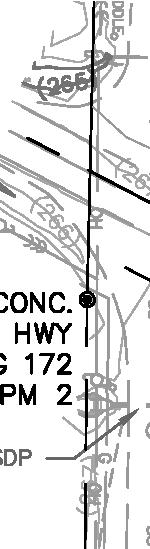
21 T:\_CS\Work\Orland, City of\pilot Flying J Travel Center\Figures (E) FLOWLINE AND DITCH (E) FLOWLINE AND DITCH SHARRAH DUNLAP SAWYER, INC. Civil Engineering Land Planning Surveying & Mapping Landscape Architecture Presentation Graphics 6590 Lockheed Drive, Redding, CA voice fax info@sdsengineering.com Source: Sharrah Dunlap Sawyer, Inc FEET SHARRAH DUNLAP SAWYER, INC. Figure 4 Site Plan Civil Engineering Land Planning Surveying & Mapping Landscape Architecture Presentation Graphics (E) FLOWLINE AND DITCH 6590 Lockheed Drive, Redding, CA voice fax info@sdsengineering.com
22
IV. ENVIRONMENTAL IMPACT ANALYSIS G. HYDROLOGY/WATER QUALITY
 IV. ENVIRONMENTAL IMPACT ANALYSIS G. HYDROLOGY/WATER QUALITY ENVIRONMENTAL SETTING The project site is located in the Wilshire community of the City of Los Angeles and is bound by S. Wetherly Drive to
Environmental Checklist Form
 Environmental Checklist Form 1. Project Title: Change of Zone No. 05-07 (Pre-Zone) and Lotus Ranch Vesting Tentative Subdivision Map 2. Lead Agency Name and Address: City of El Centro 1275 Main Street
Campus Photovoltaic Energy Project at California State University Channel Islands
 Negative Declaration and Initial Study Campus Photovoltaic Energy Project at California State University Channel Islands The Trustees of the California State University Project Proponent: California State
NOTICE OF PREPARATION OF AN ENVIRONMENTAL IMPACT REPORT
 Date: September 19, 2017 NOTICE OF PREPARATION OF AN ENVIRONMENTAL IMPACT REPORT To: Agencies and Interested Parties Lead Agency: Sacramento Municipal Utility District 6201 S Street, MS B203 Sacramento,
City of Palo Alto (ID # 7047) City Council Staff Report
 City Council Staff Report") City of Palo Alto (ID # 7047) City Council Staff Report Report Type: Consent Calendar Meeting Date: 6/13/2016 Summary Title: East Palo Alto Comment Letter Title: Approval and Authorization for the City
City of Palo Alto (ID # 7047) City Council Staff Report Report Type: Consent Calendar Meeting Date: 6/13/2016 Summary Title: East Palo Alto Comment Letter Title: Approval and Authorization for the City
3 PROJECT DESCRIPTION
 3.1 PROJECT OVERVIEW 3 PROJECT DESCRIPTION The Rocklin 60 project (proposed project) includes the subdivision of 56.9 acres of land, construction of 179 single-family, detached dwelling units, and installation
TABLE OF CONTENTS 4.17 UTILITIES AND SERVICE SYSTEMS...
 TABLE OF CONTENTS 4.17 UTILITIES AND SERVICE SYSTEMS... 4.17-1 4.17.0 Introduction... 4.17-1 4.17.1 Methodology... 4.17-2 4.17.2 Existing Conditions... 4.17-2 4.17.3 Impacts... 4.17-4 4.17.4 Applicant-Proposed
B. ALL RESIDENTIAL ALTERNATIVE
 The All Residential Alternative would include the development of residential units across the Project Site and Add Area. The All Residential Alternative would include replacement of existing uses at the
NOTICE OF PREPARATION
 NOTICE OF PREPARATION DATE: April 6, 2017 TO: FROM: SUBJECT: Responsible Agencies, Trustee Agencies, and Interested Persons Timbisha Shoshone Tribe Attn: NOP Comments P.O. Box 1779 Bishop, CA 93515 Fax:
3 REVISIONS TO THE DRAFT EIR
 3 REVISIONS TO THE DRAFT EIR This section contains changes to the text of the Draft EIR and General Plan. The changes are presented in the order in which they appear and are identified by page number.
Environmental Information Worksheet
 Environmental Information Worksheet Water System Owner (Attach additional sheets if necessary) Needs and Alternatives Provide a brief narrative that describes: Current drinking water system needs. Project
Appendix A: Notices of Preparation
 Sacramento LAFCo - Incorporation of Arden Arcade Draft EIR Appendix A: Notices of Preparation Michael Brandman Associates H:\Client (PN-JN)\3233\32330001\EIR\32330001_Sec99-00 Appendix Dividers.doc Sacramento
NOTICE OF PREPARATION
 NOTICE OF PREPARATION Date: June 12, 2014 To: From: Subject: Governor s Office of Planning and Research/State Clearinghouse Unit, Responsible Agencies, Trustee Agencies, and Interested Parties Announcement
NORCAL LOGISTICS CENTER
 NORCAL LOGISTICS CENTER Initial Study (Project File No. P12-110) Prepared for October 2012 City of Stockton Community Development Department NORCAL LOGISTICS CENTER Initial Study (Project File No. P12-110)
5.0 PROJECT ALTERNATIVES
 5.0 ALTERNATIVES 5.1 INTRODUCTION GENERAL CEQA REQUIREMENTS California Environmental Quality Act (CEQA) Guidelines Section 15126.6(a) states an EIR shall describe a range of reasonable alternatives to
CEDARS-SINAI MEDICAL CENTER WEST TOWER PROJECT ENV EIR APPENDIX A NOTICE OF PREPARATION INITIAL STUDY PUBLIC SCOPING COMMENTS
 CEDARS-SINAI MEDICAL CENTER WEST TOWER PROJECT ENV 2008-0620-EIR APPENDIX A NOTICE OF PREPARATION INITIAL STUDY PUBLIC SCOPING COMMENTS CEDARS-SINAI MEDICAL CENTER WEST TOWER PROJECT ENV 2008-0620-EIR
NIGHTTIME ILLUMINATION
 IV.A.3 NIGHTTIME ILLUMINATION 1. INTRODUCTION This section analyzes and discusses the extent to which the proposed project s artificial lighting would affect the visual environment of the project site
County of El Dorado Notice of Preparation Tilden Park Project
 County of El Dorado Tilden Park Project DATE: December 19, 2012 TO: FROM: SUBJECT: Responsible Agencies, Trustee Agencies, and Interested Parties Pierre Rivas, Principal Planner, El Dorado County (NOP)
Table of Contents. City of Redlands - Redlands Crossing Center
 City of Redlands - Redlands Crossing Center Executive Summary... ES-1 Section 1: Introduction...1-1 1.1 - Overview of the CEQA Process...1-1 1.2 - Scope of the EIR...1-5 1.3 - Organization of the EIR...1-8
South of Woodward Avenue Project
 South of Woodward Avenue Project Draft Environmental Impact Report VOLUME I OF III SCH# 2013102012 PREPARED FOR THE CITY OF MANTECA 1501 Sports Drive, Sacramento, CA 95834 Draft Environmental Impact Report
CITY OF LOS ANGELES SAN PEDRO COMMUNITY PLAN
 CITY OF LOS ANGELES SAN PEDRO COMMUNITY PLAN Environmental Impact Report SCH No. 2008021004 Volume I: Draft EIR Prepared for City of Los Angeles Department of City Planning 200 N. Spring Street, Room 667
NOTICE OF PREPARATION DUBLIN HIGH SCHOOL ENGINEERING & SCIENCE BUILDING AND INTERIM HOUSING PHASE 1B ENVIRONMENTAL IMPACT REPORT
 NOTICE OF PREPARATION DUBLIN HIGH SCHOOL ENGINEERING & SCIENCE BUILDING AND INTERIM HOUSING PHASE 1B ENVIRONMENTAL IMPACT REPORT To: State Clearinghouse Governor s Office of Planning & Research Responsible
Municipal Stormwater Management Planning
 Municipal Stormwater Management Planning Christopher C. Obropta, Ph.D., P.E. Water Resources Extension Specialist with Rutgers Cooperative Extension Assistant Professor with Department of Environmental
4.6 - Hydrology and Water Quality
 City of Wasco - Wasco Center Walmart Hydrology and Water Quality 4.6 - Hydrology and Water Quality 4.6.1 - Introduction This section provides an evaluation of hydrology and water quality. The analysis
3G. Hydrology and Water Quality
 INTRODUCTION This chapter assesses the potential impacts to surface water hydrology, surface water quality, groundwater hydrology, and groundwater quality resulting from the development of the proposed
CHAPTER 4.0 ENVIRONMENTAL SETTING, IMPACTS, AND MITIGATION
 CHAPTER 4.0 ENVIRONMENTAL SETTING, IMPACTS, AND MITIGATION Sections 4.1 through 4.14 of Chapter 4.0 of this EIR contain a discussion of the potential environmental effects from implementation of the proposed
INITIAL STUDY/MITIGATED NEGATIVE DECLARATION FOR LA SIERRA METROLINK PARKING LOT EXPANSION PROJECT
 INITIAL STUDY/MITIGATED NEGATIVE DECLARATION FOR LA SIERRA METROLINK PARKING LOT EPANSION PROJECT Prepared By: Riverside County Transportation Commission 4080 Lemon Street Riverside, California 92501 March
ADOPTION OF THE MITIGATED NEGATIVE DECLARATION
 CALIFORNIA ENVIRONMENTAL QUALITY ACT IN CONNECTION WITH THE APPROVAL OF THE TELECOMMUNICATIONS INFRASTRUCTURE IMPROVEMENTS PHASE A PROJECT UNIVERSITY OF CALIFORNIA, SANTA CRUZ CAMPUS I. ADOPTION OF THE
RIVERSIDE COUNTY ENVIRONMENTAL ASSESSMENT FORM: INITIAL STUDY
 RIVERSIDE COUNTY ENVIRONMENTAL ASSESSMENT FORM: INITIAL STUDY Environmental Assessment (E.A.) Number: EA38725 Project Case Type (s) and Number(s): CZ6699, PM30525, CUP3378 Lead Agency Name: County of Riverside
CORBIN AND NORDHOFF IV. ENVIRONMENTAL IMPACT ANALYSIS ENV EIR F. HYDROLOGY
 F. HYDROLOGY ENVIRONMENTAL SETTING Project Site The Project Site is located at 19601 Nordhoff Street in the Chatsworth area of the City of Los Angeles, California, within the Chatsworth - Porter Ranch
ENVIRONMENTAL INFORMATION FORM
 ENVIRONMENTAL INFORMATION FORM City of Fontana Planning Division The purpose of this form is to inform the city of the basic components of the proposed project so that the City may review the project pursuant
4 ALTERNATIVES. LAFCo also received input as a part of the Notice of Preparation (NOP) and scoping process regarding potential alternatives.
 and scoping process regarding potential alternatives.") 4 ALTERNATIVES CEQA requires that an EIR describe the relative environmental effects of alternatives to the proposed project and evaluate their comparative impacts and merits. LAFCo has considered a range
4 ALTERNATIVES CEQA requires that an EIR describe the relative environmental effects of alternatives to the proposed project and evaluate their comparative impacts and merits. LAFCo has considered a range
Notice of Preparation of an Environmental Impact Report and Scoping Meeting
 Notice of Preparation of an Environmental Impact Report and Scoping Meeting Date: August 15, 2017 To: Project Sponsor and Lead Agency: Staff Contact: Project Title: Location: General Plan Designation:
SAFETY AND NOISE 9. Safety and Noise
 SAFETY AND NOISE 9 9 Safety and Noise Safety is a basic human need and is required for a community to thrive. The goals and policies in this element are designed to protect and enhance public health and
Environment & Conservation Introduction
 Environment & Conservation Introduction Anacortes is blessed with an abundance of natural beauty. Residents identify marine shorelines, streams, lakes, forested areas, and other natural features as defining
County of Calaveras Department of Planning
 Date: July 18, 2013 To: From: Project: Advisory Agencies Amy Augustine, AICP - Planner County of Calaveras Department of Planning Rebecca L. Willis, AICP ~ Planning Director Phone (209) 754-6394 Fax (209)
CEQA Categorical Exemption Determination
 CEQA Categorical Exemption Determination PROPERTY INFORMATION/PROJECT DESCRIPTION Project Address Block/Lot(s) Case No. Permit No. Plans Dated Addition/ Demolition Alteration (requires HRER if over 45
Initial Study/Mitigated Negative Declaration for
 Initial Study/Mitigated Negative Declaration for SOTO STREET WIDENING FROM MULTNOMAH STREET TO NORTH MISSION ROAD W.O. # E700070 City of Los Angeles Group Bureau of Engineering Bridge Improvement CITY
INITIAL STUDY/MITIGATED NEGATIVE DECLARATION
 INITIAL STUDY/MITIGATED NEGATIVE DECLARATION WATER STREET PROJECT TENTATIVE TRACT MAP NO. 18935 (TTM-14-001) CITY OF HIGHLAND SAN BERNARDINO COUNTY, CALIFORNIA April 20, 2015 INITIAL STUDY/MITIGATED NEGATIVE
OIL AND GAS DRILLING/PRODUCTION PLAN
 OIL AND GAS DRILLING/PRODUCTION PLAN An OIL AND GAS DRILLING/PRODUCTION PLAN (PPP) provides for discretionary review of the specific design, layout and provisions for oil and gas exploration in order to
City of Los Angeles Reseda Boulevard Mixed-Use Project. Initial Study
 City of Los Angeles Reseda Boulevard Mixed-Use Project Initial Study November 2016 Reseda Boulevard Mixed-Use Project Initial Study Prepared for: City of Los Angeles 200 North Spring Street, Suite 750
Initial Study/ Mitigated Negative Declaration. Sunset Hills Development. General Plan Amendment # , Zone Change # ,
 Initial Study/ Mitigated Negative Declaration Sunset Hills Development General Plan Amendment #2016-02, Zone Change #2016-02, Vesting Tentative Tract Map #2016-03, and Site Plan Review #2016-07 February
CHAPTER 6 ADDITIONAL STANDARDS APPLYING TO SHORELAND AREAS AND PUBLIC WATERS
 CHAPTER 6 ADDITIONAL STANDARDS APPLYING TO SHORELAND AREAS AND PUBLIC WATERS Section 1 Intent. 49 Section 2 Floodplain Requirements 49 Section 3 Water-Oriented Accessory Structures 50 Section 4 Stairways,
City of Santa Paula Spears Manufacturing Helistop Project. Draft Initial Study - Negative Declaration
 Spears Manufacturing Helistop Project Draft Initial Study - Negative Declaration May 2014 Draft Initial Study Negative Declaration Prepared for: 970 Ventura Street Santa Paula, California 93061 Prepared
BEACH AND ORANGETHORPE MIXED-USE DEVELOPMENT. Initial Study. Prepared for:
 BEACH AND ORANGETHORPE MIXED-USE DEVELOPMENT Initial Study Prepared for: City of Buena Park Community Development 6650 Beach Boulevard Buena Park, California 90622 Prepared by: 151 Kalmus Drive, Suite
CEQA Categorical Exemption Determination
 CEQA Categorical Exemption Determination PROPERTY INFORMATION/PROJECT DESCRIPTION Project Address Block/Lot(s) REC & PARK: 210V HYDE STREET 0336/003 Case No. 2017-016267ENV Permit No. Addition/ Alteration
APPENDIX H Guidance for Preparing/Reviewing CEQA Initial Studies and Environmental Impact Reports
 APPENDIX H H.1 Guidance for Preparing and Reviewing CEQA Initial Studies Step 1: Consider the Project Characteristics as Provided by the Project Applicant Review the project application and draft plan
Chapter 21 Stormwater Management Bylaw
 Chapter 21 Stormwater Management Bylaw SECTION 1. PURPOSE The purpose of this Bylaw is to: implement the requirements of the National Pollutant Discharge Elimination System (NPDES) General Permit for Storm
This comparison is designed to satisfy the requirements of State CEQA Guidelines, Section (d), Evaluation of Alternatives, which state that:
, Evaluation of Alternatives, which state that:") 6.0 Comparison of Proposed Project and Alternatives This chapter summarizes the environmental advantages and disadvantages associated with the Proposed Project and the alternatives. Based upon this discussion,
6.0 Comparison of Proposed Project and Alternatives This chapter summarizes the environmental advantages and disadvantages associated with the Proposed Project and the alternatives. Based upon this discussion,
Notice of Intent to Adopt a Mitigated Negative Declaration
 COUNTY OF NAPA CONSERVATION, DEVELOPMENT & PLANNING DEPARTMENT 1195 THIRD ST., SUITE 210 NAPA, CA 94559 (707) 253-4416 Notice of Intent to Adopt a Mitigated Negative Declaration 1. Project Title: Fisher/FIV
City of Pacifica Planning Department INITIAL STUDY AND CHECKLIST
 Date: June 12, 2012 City of Pacifica Planning Department INITIAL STUDY AND CHECKLIST California Environmental Quality Act (CEQA) Requirements This report has been prepared pursuant to the California Environmental
Hollister Urban Area Water and Wastewater Master Plan and Coordinated Water Supply and Treatment Plan
 Executive Summary for Final Program Environmental Report Hollister Urban Area Water and Wastewater Master Plan and Coordinated Water Supply and Treatment Plan State Clearinghouse # 2010061069 Lead Agency:
XI. Thornton Planning Area
 XI. A. OVERVIEW The covers 120 square miles in the northwest corner of San Joaquin County. It consists primarily of low-lying Delta islands, sloughs, and large farms. The town of Thornton, a small agriculturally-based
APPENDIX A. Project Scoping
 APPENDIX A Project Scoping Notice of Preparation To: From: Agencies and Interested Parties Paul Brunner, Executive Director, Three Rivers Levee Improvement Authority Date: June 13, 2006 Subject: Notice
APPENDIX A: A.1: Santa Monica Community College District Notice of Preparation and Scoping Meeting for the Santa Monica College Malibu Campus Project
 APPENDIX A: A.1: Santa Monica Community College District Notice of Preparation and Scoping Meeting for the Environment Report, dated May 17, 2012. A.2: Santa Monica Community College District California
THRESHOLDS OF SIGNIFICANCE
 THRESHOLDS OF SIGNIFICANCE Final PREPARED FOR City of Gilroy Adopted May 3, 2004 by the Gilroy City Council THRESHOLDS OF SIGNIFICANCE Final Study Adopted May 3, 2004 PREPARED FOR City of Gilroy William
County of Merced Notice of Preparation (NOP) of an Environmental Impact Report on the Vega Solar Project (CUP )
 of an Environmental Impact Report on the Vega Solar Project (CUP )") (NOP) of an Environmental Impact Report on the Vega Date: February 6, 2013 To: From: Subject: State Clearinghouse and Interested Parties Merced County Planning Department of a Draft Environmental Impact
(NOP) of an Environmental Impact Report on the Vega Date: February 6, 2013 To: From: Subject: State Clearinghouse and Interested Parties Merced County Planning Department of a Draft Environmental Impact
Chapter 3 Dispersion BMPs
 Chapter 3 Dispersion BMPs 3.1 BMP L611 Concentrated Flow Dispersion 3.1.1 Purpose and Definition Dispersion of concentrated flows from driveways or other pavement through a vegetated pervious area attenuates
LAFCO ANNEXATION TO JURUPA COMMUNITY SERVICES DISTRICT (TTM RIVERBEND)
") 4.a. 4/17/2014 TO: FROM: Local Agency Formation Commission Adriana Romo, Local Government Analyst II SUBJECT: LAFCO 2013-10-2 ANNEXATION TO JURUPA COMMUNITY SERVICES DISTRICT (TTM 36391-RIVERBEND) PRIOR
4.a. 4/17/2014 TO: FROM: Local Agency Formation Commission Adriana Romo, Local Government Analyst II SUBJECT: LAFCO 2013-10-2 ANNEXATION TO JURUPA COMMUNITY SERVICES DISTRICT (TTM 36391-RIVERBEND) PRIOR
Appendix Y-3. Environmental Impact Comparison Social Sciences Interdisciplinary Building
 Appendix Y-3 Environmental Impact Comparison Social Sciences Interdisciplinary Building Appendix Y-3 Environmental Impact Comparison Social Sciences Interdisciplinary Building A. Introduction USC proposes
STATE OF MINNESOTA MINNESOTA POLLUTION CONTROL AGENCY FINDINGS OF FACT
 p-ear2-44b STATE OF MINNESOTA MINNESOTA POLLUTION CONTROL AGENCY IN THE MATTER OF THE DECISION ON THE NEED FOR AN ENVIRONMENTAL IMPACT STATEMENT FOR THE PROPOSED RANDY S SANITATION TRANSFER FACILITY PROPOSED
RESOLUTION NO.15- The Planning Commission of the City of La Habra does hereby resolve as follows:
 RESOLUTION NO.15- A RESOLUTION OF THE PLANNING COMMISSION OF THE CITY OF LA HABRA CERTIFYING MITIGATED NEGATIVE DECLARATION OF ENVIRONMENTAL IMPACTS 14-02 FOR A 32 UNIT MULTI-FAMILY RESIDENTIAL DEVELOPMENT
RAND CORPORATION HEADQUARTERS BUILDING. Final Environmental Impact Report
 RAND CORPORATION HEADQUARTERS BUILDING Final Environmental Impact Report State Clearinghouse No. 1999122008 Prepared by: Planning & Community Development Department 1685 Main Street Santa Monica, CA 90407-2200
Franklin County Communique to the Planning Board
 Franklin County Communique to the Planning Board PETITIONER(S): Name of Petitioner: Carolina Solar Energy II, LLC Address: 400 W. Main St. Suite 503 City/State/Zip: Durham, NC 27701 LOCATION: REQUEST FOR
CONSENT ITEM LOCAL AGENCY FORMATION COMMISSION EXECUTIVE OFFICER'S REPORT FOR MEETING OF: SEPTEMBER 11, 2017
 CONSENT ITEM 7 LOCAL AGENCY FORMATION COMMISSION EXECUTIVE OFFICER'S REPORT FOR MEETING OF: SEPTEMBER 11, 2017 Proposal Phillips Street Reorganization (City of Vista) (RO17-06) Proponent City of Vista,
North Beach Playground Initial Study/Negative Declaration. March 2017
 City of Santa Monica North Beach Playground Initial Study/Negative Declaration March 2017 Prepared by: City of Santa Monica Planning and Community Development Department 1685 Main Street Santa Monica,
Blanche Park Reservoir Decision Notice and Finding of No Significant Impact
 Blanche Park Reservoir Decision Notice and Finding of No Significant Impact U.S. Forest Service Grand Mesa, Uncompahgre, and Gunnison National Forests Delta County, Colorado INTRODUCTION The Grand Mesa
APPENDIX A. NEPA Assessment Checklist
 APPENDI A NEPA Assessment Checklist NEPA CHECKLIST DATE: January 12, 2009 PREPARER: Frederick Wells, RLA PIN and Project Title: Surplus Property Request Wilder Balter Partners Marketplace Town of Newburgh,
Appendix A Initial Study/Notice of Preparation (NOP)
") GENERAL PLAN AND DEVELOPMENT CODE UPDATE DRAFT PEIR CITY OF CLOVIS Appendices Appendix A Initial Study/Notice of Preparation (NOP) June 2014 GENERAL PLAN AND DEVELOPMENT CODE UPDATE DRAFT PEIR CITY OF
GENERAL PLAN AND DEVELOPMENT CODE UPDATE DRAFT PEIR CITY OF CLOVIS Appendices Appendix A Initial Study/Notice of Preparation (NOP) June 2014 GENERAL PLAN AND DEVELOPMENT CODE UPDATE DRAFT PEIR CITY OF
Wastewater ENVIRONMENTAL SETTING. Wastewater Collection
 4.15.3.1 ENVIRONMENTAL SETTING Wastewater Collection The City owns, operates, and maintains the local sewer lines that collect wastewater generated within the City. The existing sewer lines include a gravity
Sutter County Community Services
 Sutter County Community Services 1130 Civic Center Boulevard Yuba City, CA 95993 Animal Control Building Inspection Emergency Services Environmental Health Fire Services Planning Date: March 29, 2007 To:
CITY OF LOS ANGELES CALIFORNIA
 BOARD OF PUBLIC WORKS MEMBERS VALERIE LYNNE SHAW PRESIDENT ELLEN STEIN VICE-PRESIDENT JANICE WOOD PRESIDENT PRO-TEMPORE RONALD LOW COMMISSIONER YOLANDA FUENTES COMMISSIONER JAMES A. GIBSON SECRETARY CITY
Eastern Kern Air Pollution Control District
 Eastern Kern Air Pollution Control District Glen E. Stephens, P.E. Air Pollution Control Officer The Eastern Kern Air Pollution Control District (District) has determined Commercial Solar Power Generation
Environmental Setting, Impacts, and Mitigation Measures
 First page header CHAPTER 4 Environmental Setting, Impacts, and Mitigation Measures 4.0 INTRODUCTION TO THE ENVIRONMENTAL ANALYSIS Sections 4.1 through 4.13 of Chapter 4 of this EIR contain a discussion
Neighborhood Advisory Committee. EIR Process Overview. Chapman University April 20, 2016
 Neighborhood Advisory Committee EIR Process Overview Chapman University April 20, 2016 2 What is CEQA? California Environmental Quality Act (1970) Modeled after NEPA, but more stringent CEQA applies to
Environmental Assessment Matrix
 For FCC Use Only Date: Customer Name: Environmental Assessment Matrix Loan Number: Please complete each question. Some answers may require additional information. Attach additional documentation where
Description of Proposed Project
 Description of Proposed Project Introduction The County of Inyo (County) is proposing to update its General Plan to include policies for solar energy development within the County. The proposed Renewable
Inglewood Oil Field Specific Plan Project Environmental Impact Report Public Information Meetings
 Inglewood Oil Field Specific Plan Project Environmental Impact Report Public Information Meetings Tuesday, October 24, 2017 6:30 to 8:00 PM El Rincon Elementary School 11177 Overland Avenue Monday, October
Wetland Permit Application
 DAVID J. KLOTZLE WETLAND INSPECTOR, PHILIPSTOWN, NY 238 Main Street Cold Spring, NY 10516 (914) 736-7132 Wetland Permit Application MEMO TO APPLICANT 1. Use this form to apply for a Wetlands Permit as
ADDENDUM to the Environmental Impact Report for the Maricopa Sun Solar Complex Project
 ADDENDUM to the Environmental Impact Report for the Maricopa Sun Solar Complex Project MARICOPA SUN SOLAR COMPLEX PROJECT By Maricopa Sun, LLC (PP13297) Lot Line Adjustment 25-13 Kern County Planning and
6.20 UTILITIES SOLID WASTE
 6.20 UTILITIES SOLID WASTE 6.20.1 OVERVIEW AND SUMMARY Solid waste generated by the proposed project would be disposed primarily at the Toland Road Landfill. Prior to disposal, recyclable materials would
2 PROJECT DESCRIPTION
 The project is a landowner-initiated proposal to amend: 2 PROJECT DESCRIPTION 1. the City of Elk Grove Sphere of Influence (SOI); 2. the Sacramento Area Sewer District (SASD) SOI; and 3. the Sacramento
COMPARISON OF ALTERNATIVES
 COMPARISON OF ALTERNATIVES 0 0. Introduction This chapter compares the proposed Project to the six alternatives identified in Chapter, Project Description. Both CEQA and NEPA require analysis of a reasonable
SOURCE WATER ASSESSMENT SUMMARY BROCHURE
 SOURCE WATER ASSESSMENT SUMMARY BROCHURE CITY OF ROGUE PWS # 4100712 WHAT IS A SOURCE WATER ASSESSMENT? The Source Water Assessment was recently completed by the Department of Environmental Quality (DEQ)
4.10 LAND USE, PLANNING AND ZONING
 4.10 LAND USE, PLANNING AND ZONING This section discusses the project s consistency with applicable local, regional, and state land use policies. Consistency with the Butte County Air Quality Attainment
Medical Marijuana Ordinance
 Medical Marijuana Ordinance Initial Study Negative Declaration prepared for City of Grover Beach 154 S. Eighth Street Grover Beach, California 93433 prepared by Rincon Consultants 1530 Monterey Street,
ADDENDUM TO THE EIR. Specifically, Section of the CEQA Guidelines states:
 ADDENDUM TO THE EIR Section 15160 of the CEQA Guidelines explains that there are several mechanisms, and variations in environmental documents, that can be tailored to different situations and intended
WESTERN ENGINEERING CONSULTANTS, Inc LLC
 WESTERN ENGINEERING CONSULTANTS, Inc LLC 127 S. Denver Avenue, Ft. Lupton CO 80621 2501 Mill St. Brush, CO 80723 Ph. 303-913-7341, Fax 720-294-1330 Email: firstname.lastname@westerneci.com August 24, 2017
Existing Conditions
 3.1.4 Hydrology and Water Quality This section addresses the potential hydrology, water quality, and stormwater/flooding impacts associated with implementation of The Villages Escondido Country Club Project
CEQA Referral Initial Study and Notice of Intent to Adopt a Negative Declaration
 CEQA Referral Initial Study and Notice of Intent to Adopt a Negative Declaration Date: January 18, 2017 To: Distribution List (See Attachment A) DEPARTMENT OF PLANNING AND COMMUNITY DEVELOPMENT 1010 10
STANISLAUS COUNTY PLANNING COMMISSION STAFF REPORT
 STANISLAUS COUNTY PLANNING COMMISSION September 18, 2014 STAFF REPORT USE PERMIT APPLICATION NO. PLN2014-0048 VERIZON WIRELESS MONTPELIER ROAD REQUEST: TO INSTALL A NEW WIRELESS COMMUNICATION FACILITY
Napa County Planning Commission Board Agenda Letter
 Agenda Date: 4/19/2017 Agenda Placement: 8A Napa County Planning Commission Board Agenda Letter TO: FROM: Napa County Planning Commission Charlene Gallina for David Morrison - Director Planning, Building
Analysis of Alternatives
 4 Analysis of Alternatives CEQA mandates consideration and analysis of a reasonable range of alternatives to the proposed General Plan. According to CEQA Guidelines, the range of alternatives shall include
ENVIRONMENTAL GUIDELINES FOR PREPARATION OF AN ENVIRONMENT MANAGEMENT PLAN. Environment Protection Authority, ACT May 2009
 ENVIRONMENTAL GUIDELINES FOR PREPARATION OF AN ENVIRONMENT MANAGEMENT PLAN Environment Protection Authority, ACT May 2009 ISBN-13: 978-0-642-60494-1 ISBN-10: 0-642-60494-0 Australian Capital Territory,
West Placer Groundwater Sustainability Agency Community Meeting February 16, 6 to 8 p.m. McBean Pavilion in Lincoln
 West Placer Groundwater Sustainability Agency Community Meeting February 16, 6 to 8 p.m. McBean Pavilion in Lincoln Community meeting overview The West Placer Groundwater Sustainability Agency held its
California Environmental Quality Act Summary of Environmental Issues/Impacts Summary of Potential Mitigation Measures
 Chapter Twelve: Environmental Review Chapter Twelve: Environmental Review California Environmental Quality Act Summary of Environmental Issues/Impacts Summary of Potential Mitigation Measures September
Prepared for: City of Brea Development Services Department 1 Civic Center Circle Brea, CA
 tice of Preparation and Initial Study for the Proposed Central Park Village Mixed-Use Project and General Plan Amendment Project Environmental Report Prepared for: Development Services Department 1 Civic
PLANNED UNIT DEVELOPMENT, PLANNING APPROVAL & SUBDIVISION STAFF REPORT Date: June 4, 2015
 PLANNED UNIT DEVELOPMENT, PLANNING APPROVAL & SUBDIVISION STAFF REPORT Date: June 4, 2015 NAME SUBDIVISION NAME CC Williams Plant Subdivision CC Williams Plant Subdivision LOCATION CITY COUNCIL DISTRICT
Characteristics of Land Resources
 Chapter Chapter 1 Characteristics of Land Resources The geology, soils and topography of Woodford County T he geology, soils and topography of an area are important to the community planning process for
Background / Regulatory Requirements
 Chapter 2 Background / Regulatory Requirements This Chapter summarizes the impacts of development on stormwater quality and quantity and explains the postconstruction stormwater control requirements for