APPENDIX A. Project Scoping
|
|
|
- Doreen Bates
- 6 years ago
- Views:
Transcription
1 APPENDIX A Project Scoping

2 Notice of Preparation To: From: Agencies and Interested Parties Paul Brunner, Executive Director, Three Rivers Levee Improvement Authority Date: June 13, 2006 Subject: Notice of Preparation of a Draft Environmental Impact Report on the Feather River Levee Repair Project, and Announcement of a Public Scoping Meeting to be held on June 29, 2006, from 5:30 to 7:30 p.m. at the Yuba County Government Center, 915 Eighth Street, Marysville, CA The Three Rivers Levee Improvement Authority (TRLIA) is proposing the Feather River Levee Repair Project (FRLRP), an element of the Yuba-Feather Supplemental Flood Control Project (Y-FSFCP), to increase flood protection in the Reclamation District (RD) 784 area of Yuba County. RD 784 is bounded by the Yuba River on the north, the Feather River on the west, the Bear River on the south, and the Western Pacific Interceptor Canal (WPIC) on the east. The project would address identified deficiencies in the Feather River levee, and would make related improvements to the Yuba River levee near its confluence with the Feather River. It would entail strengthening the existing Feather River left (east) bank levee from Project Levee Mile (PLM) 13.3 to PLM 17.1 and from PLM 23.6 to PLM 26.1, and strengthening the existing Yuba River left (south) bank levee from the confluence with the Feather River (PLM 0.0) upstream to PLM 0.3. (Note: References to the left bank indicate the left side of the river when facing downstream.) The segment of the Feather River left bank levee between PLM 17.1 and PLM 23.6 would be either strengthened in its current location or set back following one of two possible alignment scenarios. Constructing a setback levee a sufficient distance from the existing levee would remove current channel constrictions in the Feather River, thereby improving the level of flood protection for the RD 784 area and for the Marysville and Yuba City areas by lowering upstream water surface elevations. If a levee setback option is selected, land uses in the setback area could consist of agricultural operations and/or habitat restoration activities that would not impede the flood flow function of the setback area. Figure 1 shows the general study area for the project in a regional context. Figure 2 shows the extent of the project site. The project is described in more detail in Overview of the Proposed Feather River Levee Repair Project below. Feather River Levee Repair Project Notice of Preparation 1
3 FEATHER RIVER LEVEE REPAIR PROJECT Project Study Area Figure 1


4 FEATHER RIVER LEVEE REPAIR PROJECT Project Features Figure 2
5 Purpose of the Notice of Preparation The California Environmental Quality Act (CEQA) specifies that a public agency must prepare an environmental impact report (EIR) on any project that it proposes to carry out or approve that may have a significant direct or indirect impact on the environment (Public Resources Code Section 21100[a]). TRLIA has determined that the FRLRP may have significant impacts on the environment. Therefore, TRLIA, as the lead agency for CEQA compliance, intends to prepare an EIR on the proposed project and has prepared this notice of preparation (NOP) as an initial step in the CEQA process. The purpose of this notice is twofold: 1. to solicit input, by July 14, 2006, from interested agencies, organizations, and individuals about the content and scope of the draft EIR (DEIR) to be prepared for the proposed project; and 2. to announce a public scoping meeting on the proposed project, to be held from 5:30 to 7:30 p.m. on Thursday June 29, 2006, at the Yuba County Government Center, 915 Eighth Street, Marysville, CA Purpose of and Need for the Feather River Levee Repair Project Background Yuba County has a long history of flooding. Floods in the Central Valley in 1986 and again in 1997 were catastrophic for Yuba County, inundating tens of thousands of acres, destroying thousands of homes and businesses, and causing loss of life. Two major flood protection efforts resulted from the 1986 Central Valley floods. First, the U.S. Army Corps of Engineers (Corps) and California Department of Water Resources (DWR) initiated the System Evaluation Project, which restored federally constructed levees in RD 784 to current design standards and reestablished the 1957 design top-of-levee profile. Most of the System Evaluation levee reconstruction work in RD 784 was completed in (Note that the 1997 floods resulted in the identification of additional levee seepage problems, which led to the Corps s System Evaluation Site 7 Extension project.) The second effort was Yuba County Water Agency s (YCWA s) initiation in 1988 of the Yuba Basin Project, which led to a Corps project designed to achieve what was then considered to be a 200-year level of protection for RD 784 levees. The Yuba Basin Feather River Levee Repair Project Notice of Preparation 4
6 Project was approved by Congress in 1998, and a construction start was authorized in In 2003, however, new Corps underseepage guidelines led to reevaluation of the project, which substantially increased the estimated cost. Because of this cost increase, the Yuba Basin Project must be reauthorized by Congress. A General Reevaluation Report is currently being prepared to obtain a new project authorization and to initiate construction. Ongoing Local Agency Efforts In response to the catastrophic flood of 1997, YCWA initiated a seven-phase program of flood control studies to identify methods to achieve a higher level of protection, particularly for the areas in RD 784 that had been subject to flooding several times in the past. The goal of this effort was to substantially improve the flood protection that would be provided by the System Evaluation Project and the Yuba Basin Project. Following the passage of the Costa-Machado Water Act (Proposition 13) by California voters in 2000, YCWA s flood control study team turned the focus of its seven-phase program of studies to those measures that could be achieved within the budget provisions of Proposition 13, which provided for a total of $90 million in bond funds targeted for the Yuba-Feather River basin. This effort, funded through Proposition 13 grant monies, is the Y-FSFCP. As part of the Y-FSFCP studies, YCWA prepared a feasibility study, including a DEIR (released in October 2003). The feasibility study and EIR evaluated combinations of three flood control elements: an outlet capacity increase at New Bullards Bar Reservoir, forecast-coordinated operations of New Bullards Bar Reservoir and Lake Oroville, and a setback of the left bank levee of the Feather River between Shanghai Bend and the Bear River. The levee setback was proposed for two segments, which were referred to as the Above Star Bend and Below Star Bend levee setback areas. (The Y-FSFCP Above Star Bend levee setback area generally corresponds to the area considered for a levee setback as part of the FRLRP [i.e., the proposed project described in this NOP]). The final EIR for the Y-FSFCP was certified and the program of elements was approved by the YCWA Board in March In May 2003, while YCWA was completing the first level of Y-FSFCP studies, the Corps, in a separate draft floodplain mapping study for DWR on the Feather River and its tributaries, identified several deficiencies in freeboard on the Bear River and WPIC levees that prevent these levees from meeting the Federal Emergency Management Agency (FEMA) criteria for providing protection for RD 784 from a 100-year flood event. This information was unexpected by Yuba County officials because the 1998 Corps Yuba Basin study did not recommend any work for the WPIC and Bear River levees to achieve a 200-year level of protection for the RD 784 area. In addition, it was found that a 2,800-foot stretch of the Yuba River levee on the upstream side of State Route (SR) 70 did not meet slope stability requirements. In 1993, following the initiation of the System Evaluation Project and the Yuba Basin Project, and before the most recent devastating flood (in 1997), Yuba County approved the Plumas Lake Specific Plan, which provides for a 12,000-home development on Feather River Levee Repair Project Notice of Preparation 5
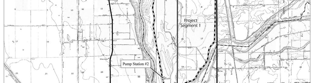
7 5,200 acres in the southern portion of the RD 784 area. Development was initiated in the Plumas Lake Specific Plan area in The results of the 2003 Corps floodplain mapping study indicate that people and property in the RD 784 area, including homes that had already been built in the Plumas Lake Specific Plan area before the release of the Corps study, are subject to a much higher flood risk than previously believed. Consequently, YCWA, RD 784, and Yuba County, in consultation with landowners and developers in the south county, elected to move aggressively on a program for improving flood control for the RD 784 area. One step was the formation of TRLIA, a joint powers authority composed of Yuba County and RD 784 focused on addressing funding and implementation of levee repairs for the RD 784 area. Based on the results of studies completed by RD 784, TRLIA, and others, the improvement program was planned to be implemented in four phases. Priority was given to implementing improvements to the Yuba River levee above SR 70 (Phase 1); improvements to the upper Bear River and WPIC levees, modifications of RD 784 Pump Station No. 6, and construction of the Olivehurst Detention Basin (Phase 2); and construction of a setback levee along the lower Bear River, tying into the Feather River levee just below Clark Slough (Phase 3). These projects are all either completed or under way. The Bear River levee setback precludes the need to improve the Feather River levee below Pump Station No. 2. The project that is the subject of this NOP, the FRLRP, consists of repairs to the Feather River levee and a small portion of the Yuba River levee near the confluence with the Feather River, from approximately Pump Station No. 2 to the railroad crossing just west of SR 70 (approximately Feather River PLM 13.3 to PLM 26.1 and Yuba River PLM 0.0 to PLM 0.3). An alternative approach to improving the existing levee segment from Feather River Levee PLM 17.1 to PLM 23.6 is a levee setback, which would be a modification of the Above Star Bend segment of the Feather River levee setback that was previously proposed and evaluated in the Y-FSFCP EIR. Overview of the Proposed Feather River Levee Repair Project Project Location The project site is in Yuba County. The site consists of portions of the left (east) bank levee of the Feather River, the left (south) bank levee of the Yuba River, and adjacent lands in the RD 784 area. As shown in Figure 2, the project site extends along the Feather River from PLM 13.3 in the south to PLM 26.1 in the north. Along the Yuba River, the project site extends from PLM 0.0 (which corresponds to PLM 26.1 on the Feather River) north to PLM 0.3. The project site is divided into three segments, with the middle segment, project Segment 2, considered for either improvements to the existing levee or a potential setback levee. Setback levee alignments being considered are shown in Figure 2 Feather River Levee Repair Project Notice of Preparation 6
8 and are described in more detail below. Existing land uses in the project area include agriculture, rural residential, and residential. Project Purpose The primary purpose of the proposed project is to correct deficiencies in the Feather and Yuba River left bank levees, and consequently to improve flood protection for the RD 784 area of Yuba County. To a large extent, levee deficiencies in the project area relate to the potential for water to seep under (underseepage) and through (throughseepage) the levee soils during flood events, potentially leading to levee failures. The project design objectives focus on measures to bring the levees into compliance with FEMA geotechnical certification requirements for underseepage or through-seepage, as well as engineering and design standards of the State of California Reclamation Board (The Reclamation Board) and the Corps. The proposed project is also intended to address areas along the Feather River levee where erosion of the levee is a concern. Summary Description of the Proposed Project Three project alternatives are being considered to meet the objectives of correcting underseepage, through-seepage, and erosion concerns identified along the Feather River and Yuba River levees. Under all project alternatives, it is anticipated that the detailed design of proposed activities in project Segments 1 and 3 (see Figure 2) would be completed in 2006 and construction would take place in For activities in project Segment 2, detailed design would occur in late 2006 and through 2007, and construction would take place in Alternative 1 The Levee Strengthening Alternative Under this alternative, levee repair and strengthening activities would be completed along the existing Feather River left bank levee from PLM 13.3 to PLM 26.1 and along the Yuba River left bank levee from PLM 0.0 to PLM 0.3 (Figure 2). Levee repairs/ strengthening would consist of various activities, including installation of cutoff walls and relief wells and placement of buried cobble in areas where erosion of the levee embankment has been identified as a problem. Note that areas where erosion is a concern are all located in project Segment 2, between PLM 17.1 and PLM 23.6 (Figure 2). In addition, the existing Pump Station No. 3 would be removed and a new pump station would be constructed farther to the east (farther from the existing levee) to correct existing seepage deficiencies related to the existing pump station location. The capacity of Pump Station No. 3 may also need to be increased to accommodate flows from operation of new relief wells installed during levee repairs. Alternative 2 The Levee Strengthening and ASB Setback Levee Alternative Under this alternative, levee repair and strengthening activities would be completed along the existing Feather River left bank levee from PLM 13.3 to PLM 17.1 and PLM 23.6 to PLM 26.1 and along the Yuba River left bank levee from PLM 0.0 to PLM 0.3 (project Feather River Levee Repair Project Notice of Preparation 7
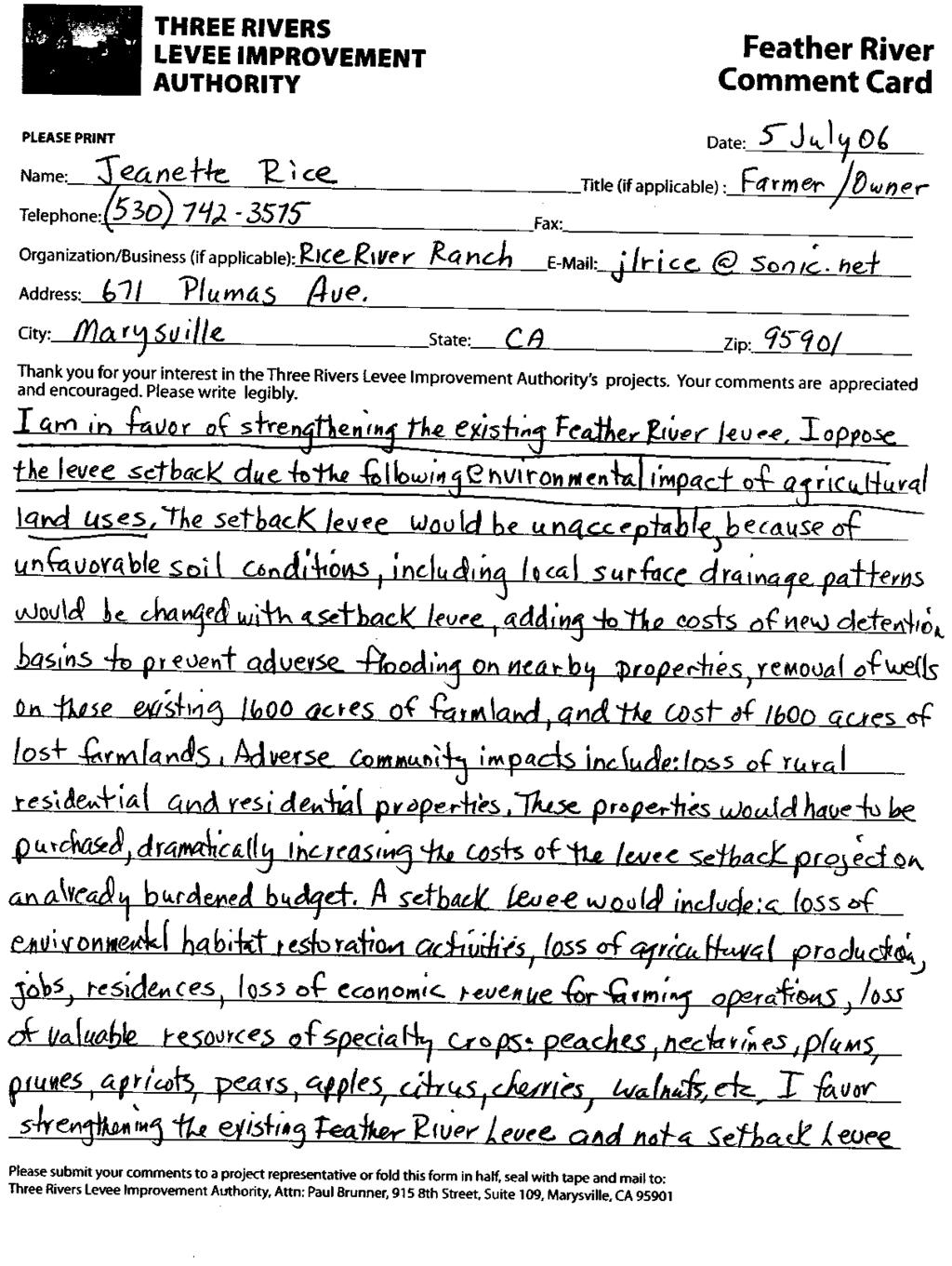
9 Segments 1 and 3 shown in Figure 2). Levee repair and strengthening activities along these segments would be the same as for Alternative 1. From PLM 17.1 to PLM 23.6 on the Feather River left bank (project Segment 2 in Figure 2), a setback levee would be constructed roughly following the Above Star Bend (ASB) setback levee alignment identified in the Y-FSFCP EIR. Portions of the existing levee along the setback alignment would be removed to allow water to flow into the new floodway/setback area (i.e., the area between the existing levee and the setback levee) during high river stages. The ASB setback levee alignment considered for this project would be approximately 5.7 miles (roughly 30,000 feet) long. The setback levee height would typically range from 20 to 30 feet above existing ground, with an average height of about 25 feet. The levee would average about 170 feet wide at its base and would cover a total of roughly 120 acres. In addition, a 50-foot-wide access corridor would be maintained along the toe of both sides of the setback levee. Approximately 2.7 million cubic yards of borrow material would be required to construct the setback levee. Borrow material could potentially come from lands on either side of the setback levee alignment and/or from the existing levee embankment. Because of unfavorable soil conditions, various seepage control measures are anticipated to be needed for the setback levee. These could include zoned embankments, slurry cutoff walls, seepage berms, and relief wells. In addition, local surface drainage patterns would be changed by the setback levee on the land side (i.e., east side) of the levee, necessitating the creation of one or more detention basins to prevent adverse flooding effects on nearby properties. Pump Station No. 3 would need to be moved from its existing location to the land side of the setback levee. The capacity of Pump Station No. 3 may also need to be increased to accommodate flows from the operation of new relief wells installed as part of the project. Approximately 1,600 acres of land would become part of the new floodway/setback area. This area contains several residences and approximately 30 other structures that would need to be removed. Removal or protection of utilities and wells in the levee setback area would also be required. Appropriate compensation would be negotiated with landowners affected by the setback levee footprint, the access corridor along the levee toe, and the expansion of the Feather River floodway. Land uses in the levee setback area could consist of agricultural operations and/or habitat restoration activities that would not impede the flood flow function of the setback area. There are no specific plans for habitat restoration in the levee setback area at this time, although this is considered a potential future use. Lands in the floodway would be contoured and managed to prevent fish stranding after high flows recede. Construction of the setback levee would correct underseepage, through-seepage, and erosion deficiencies in the existing levee by providing a replacement levee that meets design requirements of FEMA, The Reclamation Board, and the Corps. In addition, the setback levee would provide increased flood storage capacity in the levee setback area and would remove an existing narrow area in the levee system. Both of these changes Feather River Levee Repair Project Notice of Preparation 8
10 would result in a reduction in Feather River and Yuba River flood stages upstream of the setback area. Alternative 3 The Levee Strengthening and Intermediate Setback Levee Alternative FRLRP Alternative 3 is the same as Alternative 2 except for modifications to a portion of the setback levee alignment. The same levee repair and strengthening activities described previously would be completed along the existing Feather River left bank levee from PLM 13.3 to PLM 17.1 and from PLM 23.6 to PLM 26.1, and along the Yuba River left bank levee from PLM 0.0 to PLM 0.3 (project Segments 1 and 3 shown in Figure 2). From PLM 17.1 to PLM 23.6 on the Feather River left bank (project Segment 2 in Figure 2) a setback levee would be constructed. The southern one-third of this setback levee alignment would follow the ASB setback levee alignment identified in Alternative 2. However, in the vicinity of Anderson Avenue, the setback levee alignment would shift west several hundred feet. This westward shift in the intermediate setback levee alignment would allow less overall land to be placed in the new floodway and would reduce the number of houses, structures, and other facilities that would be affected by levee construction or would need to be removed from the floodway. For the portion of the intermediate setback levee that deviates from the ASB setback levee alignment, a specific route has not yet been confirmed and several options are currently being considered. Figure 2 shows two examples of potential intermediate setback levee routes. Considerations for final route selection include the suitability of underlying soil conditions for levee construction and the extent of flood control benefits as the setback levee is moved westward (i.e., less widening of the Feather River highwater channel would result in fewer flood control benefits). The intermediate setback levee alignment would be approximately 5.5 miles (roughly 29,000 feet) long. The setback levee height would typically range from 20 to 30 feet above existing ground, with an average height of about 25 feet. The levee would average about 170 feet wide at its base and would cover a total of roughly 110 acres. Approximately 2.6 million cubic yards of borrow material would be required to construct the setback levee. Most of the design, construction, and operational characteristics of the ASB setback levee described for Alternative 2 would also apply to the intermediate setback levee under Alternative 3, including the following: A 50-foot-wide access corridor would be maintained along the toe of both sides of the setback levee. Borrow material could potentially come from lands on either side of the setback levee alignment, or from the existing levee embankment. Because of unfavorable soil conditions, various seepage control measures are anticipated to be needed for the setback levee that could include zoned embankments, slurry cutoff walls, seepage berms, and relief wells. Feather River Levee Repair Project Notice of Preparation 9
11 Local land side drainage patterns would be changed by the setback levee, necessitating the creation of detention basin(s) to prevent adverse flooding effects on nearby properties. Pump Station No. 3 would need to be relocated to the east side of the setback levee. The capacity of Pump Station No. 3 may need to be increased to accommodate flows from the operation of new relief wells installed as part of the project. Land uses in the levee setback area could consist of agricultural operations and/or habitat restoration activities that would not impede the flood flow function of the setback area. (There are no specific plans for habitat restoration in the setback area at this time, although this is considered a potential future use.) Lands in the floodway would be contoured and managed to prevent fish stranding after high flows recede. Approximately 1,300 acres of land would become part of the new floodway/setback area. This area contains several residences (although somewhat fewer residences than under Alternative 2) and approximately 30 other structures that would need to be removed. Removal or protection of utilities and wells in the levee setback area would also be required. Appropriate compensation would be negotiated with landowners affected by the setback levee footprint, the access corridor along the levee toe, and the expansion of the Feather River floodway. Type of EIR The FRLRP EIR is a project EIR. The Y-FSFCP EIR evaluated the environmental effects of an ASB setback levee similar to the levee setback considered under Alternatives 2 and 3 of the FRLRP. Therefore, much of the information in the Y-FSFCP EIR is applicable to the FRLRP impact analysis, and the appropriate portions of the Y-FSFCP EIR will be incorporated by reference into the FRLRP EIR. Issues to Be Addressed in the EIR The FRLRP EIR will describe the adverse and beneficial environmental effects of implementing the proposed project. The document will also evaluate any indirect effects of the proposed project, such as potential growth-inducing effects, and the cumulative effects of implementing the proposed project in conjunction with other related past, present, and reasonably foreseeable future projects. All three project alternatives described above will be analyzed at an equal level of detail in the FRLRP EIR. The EIR will also evaluate a No Project Alternative. In addition, the EIR will describe the alternatives selection process and discuss other alternatives considered but not carried forward for detailed analysis. Feather River Levee Repair Project Notice of Preparation 10
12 On the basis of preliminary consideration of the project, TRLIA has determined that one or more of the proposed project alternatives could result in significant and potentially significant environmental impacts in the following resource areas: Land Use (including agriculture) Geology and Soils Water Resources and Geomorphology Fisheries Terrestrial Biological Resources Recreation Aesthetic Resources Cultural Resources Air Quality Noise Transportation and Circulation Public Services, Utilities, and Service Systems Paleontological Resources On the basis of the preliminary consideration of the project elements, no environmental impacts are anticipated for the following resource areas: Mineral Resources and Population and Housing. There are no known mineral resources in the project area, and the project would not directly result in substantial population growth or create the need for a substantial amount of new housing. Therefore, these topics will not be analyzed in detail in the EIR. However, as described above, the EIR will include analysis of various additional topics required by CEQA, such as cumulative impacts and growth-inducing effects. Project Scoping and Agency Roles/Responsibilities Project Scoping Scoping is an important initial component of the CEQA review process for the proposed project. Scoping will help to identify the final range of project actions, site design options, impact mechanisms considered, mitigation measures, and other elements of the EIR review. The scoping process may also help eliminate from detailed study those issues that are not critical to the decision at hand. It is also an effective way to bring together and resolve the concerns of interested federal, state, and local agencies; specific stakeholder groups; and the general public. Role of TRLIA As the lead agency under CEQA for the FRLRP EIR, TRLIA will continue to coordinate with responsible and trustee agencies (as defined by CEQA), relevant federal agencies, and other interested parties. TRLIA will be principally responsible for conducting the environmental review process, including scoping, preparing appropriate environmental documentation, deciding whether to certify the EIR, and selecting and approving a preferred alternative. If the project moves forward, TRLIA would coordinate with the Corps, DWR, and The Reclamation Board to implement the project. Feather River Levee Repair Project Notice of Preparation 11
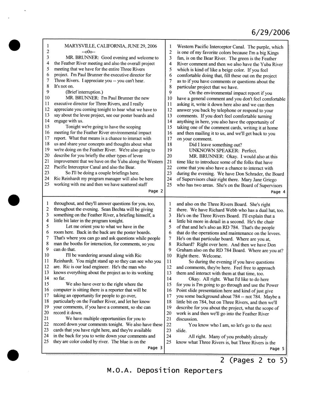
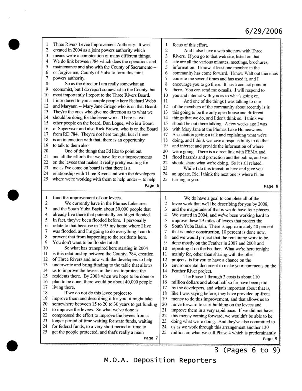
13 Other Agency Roles The following other public agencies may have jurisdiction over elements of the FRLRP or have responsibility for resources that could be affected by the project: U.S. Army Corps of Engineers U.S. Fish and Wildlife Service National Marine Fisheries Service California Department of Water Resources The Reclamation Board California Department of Fish and Game (Region 2) California Environmental Protection Agency Central Valley Regional Water Quality Control Board (Region 5) California State Lands Commission California State Office of Historic Preservation California Department of Transportation Yuba County Yuba County Water Agency Reclamation District 784 Feather River Air Quality Management District Compliance with the National Environmental Policy Act (NEPA) is also necessary when there is federal participation in a project; a federal discretionary permit, entitlement, authorization, or federal funding is required; or the project would occur on federal lands. Because the proposed project involves the modification of federal levees, it is expected to involve some level federal permitting, authorizations, and/or funding. Project elements are also expected to require Corps permitting under Section 404 of the Clean Water Act. The project is therefore expected to require NEPA compliance. NEPA compliance would be undertaken separately from the CEQA review process. Scoping Meeting A public scoping meeting for the proposed Feather River Levee Repair Project will be held from 5:30 to 7:30 p.m. on Thursday, June 29, 2006, at at the Yuba County Government Center, 915 Eighth Street, Marysville, CA The objectives of the meeting will be to: brief interested parties on the current status of flood control studies and flood control projects that have been completed or are under way, provide background information on the proposed Feather River Levee Repair Project and the alternatives being considered, and obtain the views of agency representatives and the public on the scope and content of the proposed EIR. An informational presentation will be held in conjunction with the scoping meeting. This presentation will provide updates on the various flood control projects being undertaken Feather River Levee Repair Project Notice of Preparation 12
14 by TRLIA and will offer an opportunity to ask questions on projects other than the FRLRP. The scoping meeting will be accessible to persons with disabilities. Individuals needing special services will be accommodated to the fullest extent possible. For more information, contact Danielle Wilson at (916) ( at least 48 hours prior to the meeting. Providing Comments on the NOP Interested parties are invited to provide comments in response to this NOP at the scoping meeting described above and may also provide TRLIA with written comments. Because of time limits mandated by state law, written comments should be provided to TRLIA no later than 5:00 p.m. on July 14, Agencies that will need to use the EIR when considering permits or other approvals for the proposed project should provide TRLIA with the name of the staff contact person. Please send all written comments to: Paul Brunner Attn: Three Rivers Levee Improvement Authority Government Center 915 Eighth Street, Suite 115 Marysville, CA Telephone: (530) Fax: (530) Feather River Levee Repair Project Notice of Preparation 13
15
16
17
18
19
20
21
22
23
24
25
26
27
28
29
30
31
32
33
34
35
36
37
38
39
40
41
42
43
44
45
NOTICE OF PREPARATION
 NOTICE OF PREPARATION Date: June 12, 2014 To: From: Subject: Governor s Office of Planning and Research/State Clearinghouse Unit, Responsible Agencies, Trustee Agencies, and Interested Parties Announcement
Marysville Levee Commission
 Marysville Levee Commission Outline CVFPP Goals & Objectives Highlights of Draft Feather River RFMP Integration between Flood Protection, Agriculture and Wildlife and Floodplain Uses Proposed Projects
FINDINGS OF FACT AND STATEMENT OF OVERRIDING CONSIDERATIONS
 WEST SACRAMENTO AREA FLOOD CONTROL AGENCY SOUTHPORT SACRAMENTO RIVER EARLY IMPLEMENTATION PROJECT (BORROW ONE PROJECT) FINDINGS OF FACT AND STATEMENT OF OVERRIDING CONSIDERATIONS P R E P A R E D F O R
Subject: Notice of Preparation of a Draft Environmental Impact Report
 NOTICE OF PREPARATION From: Santa Clara Valley Water District 5750 Almaden Expressway San Jose, CA 95118 Subject: Notice of Preparation of a Draft Environmental Impact Report Project Title: Guadalupe Dam
Subject: Notice of Preparation of a Draft Environmental Impact Report
 NOTICE OF PREPARATION From: Santa Clara Valley Water District 5750 Almaden Expressway San Jose, CA 95118 Subject: Notice of Preparation of a Draft Environmental Impact Report Project Title: Calero Dam
Draft Environmental Impact Report
 Revised Draft Environmental Impact Report San Francisquito Creek Flood Protection, Ecosystem Restoration, and Recreation Project Upstream of Highway 101 This notice announces that a Draft Environmental
Sacramento Area Flood Control Agency. May State Clearinghouse No Prepared for: Prepared by: Consulting Engineers and Scientists
 Addendum No. 3 (North Sacramento Streams) to the Environmental Impact Report on the North Sacramento Streams, Sacramento River East Levee, Lower American River, and Related Flood Improvements Project Prepared
THREE RIVERS LEVEE IMPROVEMENT AUTHORITY 1114 Yuba Street, Suite 218 Marysville, CA Office (530) Fax (530)
 Fax (530)") THREE RIVERS LEVEE IMPROVEMENT AUTHORITY 1114 Yuba Street, Suite 218 Marysville, CA 95901 Office (530) 749-7841 Fax (530) 749-6990 November 20, 2013 Mr. Eric Simmons Regional Engineer, FEMA Region IX 1111
THREE RIVERS LEVEE IMPROVEMENT AUTHORITY 1114 Yuba Street, Suite 218 Marysville, CA 95901 Office (530) 749-7841 Fax (530) 749-6990 November 20, 2013 Mr. Eric Simmons Regional Engineer, FEMA Region IX 1111
LEVEE DISTRICT NO. 1 OF SUTTER COUNTY
 LEVEE DISTRICT NO. 1 OF SUTTER COUNTY STAR BEND SETBACK LEVEE AND HABITAT ENHANCEMENT PROJECT BASIS OF DESIGN FEBRUARY 2009 Prepared By: TABLE OF CONTENTS QUALITY CONTROL CERTIFICATION... iv 1.0 INTRODUCTION...
Notice of Preparation of Environmental Impact Report
 Notice of Preparation of Environmental Impact Report September 29, 2010 TO: State Clearinghouse Responsible and Trustee Agencies Interested Agencies and Parties FROM: Sonoma County Water Agency 404 Aviation
Lower San Joaquin River Feasibility Study PLAN FORMULATION ADDENDUM
 PLAN FORMULATION ADDENDUM Non-Structural Measure Descriptions Elevate Critical Infrastructure This measure would raise at-risk critical structures above the design inundation level. Elevation would be
Public Notice. Applicant: City of Dallas Project No.: SWF Date: April 18, Name: Chandler Peter Phone Number:
 Public Notice Applicant: City of Dallas Project No.: SWF- 2014-00151 Date: April 18, 2014 The purpose of this public notice is to inform you of a proposal for work in which you might be interested. It
5th Street Bridge Replacement Project Yuba City, California Location Hydraulic Study Report Bridge No. 18C0012
 EA 03-0L2324 Yuba City, California Location Hydraulic Study Report Submitted to: Prepared by: November 2012 Table of Contents Executive Summary... iii Acronyms... v 1 General Description... 1 1.1 Project
Project Information. Pursuant to Section 404 of the Clean Water Act (33 U.S. Code 1344), notice is hereby given that
, notice is hereby given that") US ARMY Corps Of Engineers Little Rock District JOINT PUBLIC NOTICE CORPS OF ENGINEERS STATE OF MISSOURI Application Number: SWL 2013-00260 Date: April 15, 2014 Comments Due: May 6, 2014 TO WHOM IT MAY
US ARMY Corps Of Engineers Little Rock District JOINT PUBLIC NOTICE CORPS OF ENGINEERS STATE OF MISSOURI Application Number: SWL 2013-00260 Date: April 15, 2014 Comments Due: May 6, 2014 TO WHOM IT MAY
Notice of Intent to Prepare a Draft Environmental Impact Statement for the
 BILLING CODE: 3720-58 This document is scheduled to be published in the Federal Register on 02/10/2017 and available online at https://federalregister.gov/d/2017-02779, and on FDsys.gov DEPARTMENT OF DEFENSE
Paul Brunner, Larry Dacus, Doug Handen. Repairs to Concrete-Lined V-Ditch Alternatives Evaluation
 Memo To: Paul Brunner, Larry Dacus, Doug Handen From: Alberto Pujol /Dan Wanket Date: 09/10/2010 Re: Feather River Levee Site 7 Extension Repairs to Concrete-Lined V-Ditch Alternatives Evaluation This
AGENCY: Department of the Army; Corps of Engineers; and Texas Commission on Environmental Quality
 DEPARTMENT OF THE ARMY GALVESTON DISTRICT, CORPS OF ENGINEERS P. O. BOX 1229 GALVESTON, TEXAS 77553-1229 April 11, 2017 AGENCY: Department of the Army; Corps of Engineers; and Texas Commission on Environmental
By Roger Churchwell San Joaquin Area Flood Control Agency.
 By Roger Churchwell San Joaquin Area Flood Control Agency www.sjafca.com Urban flood control facilities have preformed over the last 59 years Locally we are at the bottom of the bathtub Nearly 500,000
SECTION 1: INTRODUCTION
 SECTION 1: INTRODUCTION 1.1 - Overview, Purpose, and Authority of the EIR 1.1.1 - Overview This Draft Environmental Impact Report (Draft EIR) considers a project that includes a series of actions resulting
Technical Memorandum No. 8 June 3, 2013 Page 2. FEMA Floodplain Mapping Flood Elevations at WWTP
 Page 2 FEMA Floodplain Mapping Flood Elevations at WWTP Existing Flood Control Facilities The City of Davis WWTP is located immediately north of the Willow Slough Bypass and west of the Yolo Bypass (see
Purpose of the EIR. Chapter 1 Introduction
 Chapter 1 Introduction Purpose of the EIR The County of Monterey (County) has prepared this environmental impact report (EIR) to provide the public, responsible agencies, and trustee agencies with information
Notice of Preparation for the Copeland Creek Stormwater Detention Basin (CIP Project )
") Copeland Creek Stormwater Detention Basin (CIP Project 2006-04) Date: December 20, 2017 To: Public Agencies and Interested Persons From: Mary Grace Pawson, Director of Development Services, City of Rohnert
Copeland Creek Stormwater Detention Basin (CIP Project 2006-04) Date: December 20, 2017 To: Public Agencies and Interested Persons From: Mary Grace Pawson, Director of Development Services, City of Rohnert
JOINT PUBLIC NOTICE U.S. ARMY CORPS OF ENGINEERS
 ISSUE DATE: February 23, 2018 EXPIRATION DATE: March 25, 2018 JOINT PUBLIC NOTICE U.S. ARMY CORPS OF ENGINEERS Availability of draft Environmental Assessment, draft Finding of No Significant Impact, and
The Nature Conservancy Cosumnes River Preserve Franklin Boulevard Galt CA 95632
 Study Partners The Nature Conservancy Cosumnes River Preserve 13501 Franklin Boulevard Galt CA 95632 East Bay Municipal Utility District 1 Winemaker Way, Unit K Lodi CA 95240 Sacramento County Water Agency
SECTION 9.0 Effects Found Not To Be Significant
 SECTION 9.0 Effects Found Not To Be Significant 9.0 EFFECTS FOUND NOT TO BE SIGNIFICANT The City of Santa Clarita conducted an Initial Study in April 2006 to determine significant effects of the proposed
Yuba County IRWMP 2015 UPDATE APPENDIX 10-1 General Plan Relation to IRWMP
 APPENDIX 10-1 General Plan Relation to IRWMP 1 of 13 Community Development Element Goal CD11: Quality of Life and Local Advantages Provide a high quality of life and take advantage of the County s economic
Staff contact: Mr. Bob Holden, Principal Engineer Phone: (831) Fax: (831)
 Fax: (831)") SUPPLEMENT TO THE MAY 2013 NOTICE OF PREPARATION FOR THE MONTEREY PENINSULA GROUNDWATER REPLENISHMENT (PURE WATER MONTEREY) PROJECT ENVIRONMENTAL IMPACT REPORT TO: Agencies, Interested Parties, and Members
SUPPLEMENT TO THE MAY 2013 NOTICE OF PREPARATION FOR THE MONTEREY PENINSULA GROUNDWATER REPLENISHMENT (PURE WATER MONTEREY) PROJECT ENVIRONMENTAL IMPACT REPORT TO: Agencies, Interested Parties, and Members
Project Scoping Meeting Thousand Palms Flood Control Project EIR/EIS
 Project Scoping Meeting Thousand Palms Flood Control Project EIR/EIS Thousand Palms Community Center December 6, 2016 6:00 p.m. Coachella Valley Water District Meeting Agenda Introductions CEQA Lead Agency:
Station 1 Project Location
 Station 1 Project Location SUTTER BYPASS FEATHER RIVER Fremont Weir NATOMAS CROSS CANAL PLEASANT GROVE CREEK CANAL PLEASANT GROVE CREEK SUTTER CO PLACER CO YOLO BYPASS SACR AMENTO RIVER (STEELHEAD CREEK)
APPENDIX A NOTICE OF PREPARATION/ NOTICE OF INTENT. Proposed Lower Yuba River Accord June 2007 Draft EIR/EIS
 APPENDIX A NOTICE OF PREPARATION/ NOTICE OF INTENT Proposed Lower Yuba River Accord June 2007 Draft EIR/EIS Proposed Lower Yuba River Accord June 2007 Draft EIR/EIS Interested Parties NOTICE OF PREPARATION
Notice No Closing Date: May 12, 2017
 Public Notice U.S. Army Corps of Engineers Pittsburgh District In Reply Refer to Notice No. below US Army Corps of Engineers, Pittsburgh District 1000 Liberty Avenue Pittsburgh, PA 15222-4186 Application
9.1 Yuba County IRWMP Region Flood Management History
 Chapter 9 Flood Management 9.0 Introduction The watersheds of the Feather, Yuba, and Bear Rivers are capable of generating rapid and extreme peak flows during certain Pacific storm events from the southwest
Public Scoping Meetings
 Public Scoping Meetings GRASS VALLEY Wednesday, March 9, 2016 6:00 8:00 p.m. Holiday Inn Express 121 Bank Street Grass Valley, CA 95945 AUBURN Thursday, March 10, 2016 6:00 8:00 p.m. Forest Lake Christian
THIS IS NOT A PAID ADVERTISEMENT. Public Notice. Public Notice No. CENAP-OP-R November 21, 2017
 THIS IS NOT A PAID ADVERTISEMENT Public Notice U.S. Army Corps of Engineers Wanamaker Building 100 Penn Square East Philadelphia, PA 19107-3390 ATTN: CENAP-OP-R Public Notice No. Date CENAP-OP-R-2017-00716
Manhattan Levee Section 216 Feasibility Study Public Workshop 17Apr13 Manhattan Kansas
 Manhattan Levee Section 216 Feasibility Study Public Workshop 17Apr13 Manhattan Kansas Tuttle Creek Dam and Lake Kansas City District Project Development Team Manhattan, KS US Army Corps of Engineers 1
A collaborative strategy for optimizing management of the river corridor. Wednesday, June 2, 2010
 A collaborative strategy for optimizing management of the river corridor. Wednesday, June 2, 2010 Lower Feather River CMP Overview Map The Aerial Photo of the entire Big Picture Lower Feather River CMP
Northwest State Route 138 Corridor Improvement Project
 Northwest State Route 138 Corridor Improvement Project Los Angeles County, CA DISTRICT 7- LA- 138 (PM 0.0/36.8); DISTRICT 7- LA- 05 (PM 79.5/83.1); DISTRICT 7- LA- 14 (PM 73.4/74.4) 265100/ 0700001816
RESOLUTION NO:
 RESOLUTION NO: 11-031 A RESOLUTION OF THE CITY COUNCIL OF THE CITY OF PASO ROBLES CERTIFYING THE FINAL ENVIRONMENTAL IMPACT REPORT FOR THE 2011 CIRCULATION ELEMENT OF THE GENERAL PLAN AND ADOPTING FINDINGS,
Lower Sacramento / Delta North Region: CORRIDOR MANAGEMENT FRAMEWORK
 Lower Sacramento / Delta North Region: CORRIDOR MANAGEMENT FRAMEWORK WHAT IS THIS? A coalition of local agencies developed this (CMF) for the Lower Sacramento / Delta North Region. For the purposes of
10.1 Summary Comparison of Proposed Project
 Chapter Soils. Summary Comparison of Proposed Project A summary comparison of quantifiable impacts on soils is provided in Figure -0. This figure provides information on the impact of loss of topsoil (expressed
Availability of Draft Environmental Impact Statement for the Dallas. Floodway Project, in the City of Dallas, Dallas County, TX
 This document is scheduled to be published in the Federal Register on 04/18/2014 and available online at http://federalregister.gov/a/2014-08795, and on FDsys.gov BILLING CODE: 3720-58 DEPARTMENT OF DEFENSE
County of San Diego DEPARTMENT OF PARKS AND RECREATION. Administrative Office: (858) Fax: (858) Reservations: (858)
 Fax: (858) Reservations: (858)") BRIAN ALBRIGHT DIRECTOR County of San Diego DEPARTMENT OF PARKS AND RECREATION Administrative Office: (858) 694-3030 Fax: (858) 495-5841 Reservations: (858) 565-3600 www.sdparks.org NOTICE OF PREPARATION
BRIAN ALBRIGHT DIRECTOR County of San Diego DEPARTMENT OF PARKS AND RECREATION Administrative Office: (858) 694-3030 Fax: (858) 495-5841 Reservations: (858) 565-3600 www.sdparks.org NOTICE OF PREPARATION
Public Notice of Application for Permit
 US Army Corps of Engineers Alaska District Regulatory Division (1145) CEPOA-RD Post Office Box 6898 JBER, Alaska 99506-0898 Public Notice of Application for Permit PUBLIC NOTICE DATE: January 15, 2014
Folsom Dam Water Control Manual Update
 Folsom Dam Water Control Manual Update Stakeholder Discussion October 31, 2013 Location: Tsakopoulos Library Galleria, East Room, 828 I Street, Sacramento US Army Corps of Engineers WELCOME & INTRODUCTIONS
PUBLIC NOTICE Application for Permit
 PUBLIC NOTICE Application for Permit Issue Date: March 4, 2016 Expiration Date: April 4, 2016 US Army Corps of Engineers No: NWP-2015-432 30-Day Notice Oregon Department of State Lands No: 58511 Interested
Notice of Preparation
 Notice of Preparation Date April 23, 2015 To: Subject: Project: Lead Agency: California Office of Planning and Research, Responsible and Trustee Agencies and Interested Parties Notice of Preparation of
Project Information. Pursuant to Section 404 of the Clean Water Act (33 U.S. Code 1344), notice is hereby given that
, notice is hereby given that") US ARMY Corps Of Engineers Little Rock District JOINT PUBLIC NOTICE CORPS OF ENGINEERS STATE OF ARKANSAS Application Number: 2014-00083-1 Date: December 22, 2014 Comments Due: January 16, 2015 TO WHOM
US ARMY Corps Of Engineers Little Rock District JOINT PUBLIC NOTICE CORPS OF ENGINEERS STATE OF ARKANSAS Application Number: 2014-00083-1 Date: December 22, 2014 Comments Due: January 16, 2015 TO WHOM
6. Cumulative Impacts
 6.1 OVERVIEW Section 15355 of the California Environmental Quality Act (CEQA) Guidelines defines cumulative impacts as: "...two or more individual effects which when considered together, are considerable
1.0 Introduction. 1.1 Project Background
 Gaviota Coast Plan Final EIR This chapter provides an overview of the Environmental Impact Report (EIR) for the proposed Gaviota Coast Plan (proposed Plan). The proposed Plan is described in detail in
PUBLIC NOTICE. Section 404 of the Clean Water Act (33 U.S.C. 1344) Section 10 of the Rivers and Harbors Act of 1899 (33 U.S.C.
 Section 10 of the Rivers and Harbors Act of 1899 (33 U.S.C.") US Army Corps Of Engineers Wilmington District PUBLIC NOTICE Issue Date: June 17, 2014 Comment Deadline: July 17, 2014 Corps Action ID#: SAW-2009-00655 NC DOT TIP: R-4903 The Wilmington District, Corps
US Army Corps Of Engineers Wilmington District PUBLIC NOTICE Issue Date: June 17, 2014 Comment Deadline: July 17, 2014 Corps Action ID#: SAW-2009-00655 NC DOT TIP: R-4903 The Wilmington District, Corps
APPENDIX N Guidance for Preparing/Reviewing CEQA Initial Studies and Environmental Impact Reports
 APPENDIX N N.1 Guidance for Preparing and Reviewing CEQA Initial Studies Step 1: Consider the Project Characteristics as Provided by the Project Applicant Review the project application and draft plan
Public Notice: Application for Permit
 US Army Corps Of Engineers Walla Walla District 201 North Third Avenue Walla Walla, WA 99362-1876 Public Notice: Application for Permit APPLICATION : NWW-2008-00579 WATERWAY: Bruno Creek Drainage, Pat
Carpinteria Valley Water District Carpinteria Advanced Purification Project
 NOTICE OF PREPARATION AND SCOPING MEETING Carpinteria Valley Water District Carpinteria Advanced Purification Project TO: Agencies, Organizations, and Interested Parties DATE: January 7, 2019 SUBJECT:
1 INTRODUCTION 1.1 PROJECT REQUIRING ENVIRONMENTAL ANALYSIS 1.2 PURPOSE AND INTENDED USES OF THIS DRAFT EIR
 1 INTRODUCTION This draft environmental impact report (DEIR) evaluates the environmental impacts of the proposed Resources Building Replacement Project (project). This DEIR has been prepared under the
CHAPTER 7. San Dieguito River Flooding Adaptation
 CHAPTER 7 San Dieguito River Flooding Adaptation This chapter includes a range of adaptation measures to address vulnerabilities from flooding along the San Dieguito River, including the river valley,
DEPARTMENT OF THE ARMY U.S. ARMY CORPS OF ENGINEERS, SACRAMENTO DISTRICT 1325 J STREET SACRAMENTO CA PUBLIC NOTICE
 DEPARTMENT OF THE ARMY U.S. ARMY CORPS OF ENGINEERS, SACRAMENTO DISTRICT 1325 J STREET SACRAMENTO CA 95814-2922 Operations and Readiness Branch PUBLIC NOTICE REQUEST FOR PERMISSION TO MODIFY A U.S. ARMY
Notice of Preparation For Link Union Station (Link US) Project. Joint Environmental Impact Statement and Environmental Impact Report
 Project. Joint Environmental Impact Statement and Environmental Impact Report") Notice of Preparation For Link Union Station (Link US) Project Joint Environmental Impact Statement and Environmental Impact Report Date: May 27, 2016 To: Subject: Project Title: From: All Interested Agencies,
Notice of Preparation For Link Union Station (Link US) Project Joint Environmental Impact Statement and Environmental Impact Report Date: May 27, 2016 To: Subject: Project Title: From: All Interested Agencies,
State of California Department of Water Resources
 Yolo Bypass Salmonid Habitat Restoration & Fish Passage Environmental Impact Statement Environmental Impact Report Presentation for the Yolo Bypass Fisheries Enhancement Planning Team March 20, 2014 (Abridged)
Public Notice. Public Notice No. Date: April 8, 2016 CENAP-PL-E Comment Period Closes: May 9, 2016
 Public Notice Public Notice No. Date: April 8, 2016 CENAP-PL-E-16-02 Comment Period Closes: May 9, 2016 USACE Philadelphia District: http://www.nap.usace.army.mil COBBS CREEK FISH PASSAGE PROJECT SECTION
Sutter County Community Services
 Sutter County Community Services 1130 Civic Center Boulevard Yuba City, CA 95993 Animal Control Building Inspection Emergency Services Environmental Health Fire Services Planning Date: March 29, 2007 To:
SACRAMENTO SUPPLEMENTAL PROJECTS OVERVIEW
 1 SACRAMENTO SUPPLEMENTAL PROJECTS OVERVIEW 131 132 122 8 119 27 252 174.59 11 135 12 112 92 56 CAMERON SESSIONS SUPPLEMENTAL PROGRAM MANAGER 239 65 53 18 October 218 - American River Common Features WRDA
This is a digital document from the collections of the Wyoming Water Resources Data System (WRDS) Library.
 Library.") This is a digital document from the collections of the Wyoming Water Resources Data System (WRDS) Library. For additional information about this document and the document conversion process, please contact
This is a digital document from the collections of the Wyoming Water Resources Data System (WRDS) Library. For additional information about this document and the document conversion process, please contact
East Garden Grove-Wintersburg Channel (OCFCD Facility No. C05) from upstream Warner Avenue to downstream Goldenwest Street.
 from upstream Warner Avenue to downstream Goldenwest Street.") Facility. C05) from upstream Warner Avenue to Lead Agency: Agency: Project Director: Address: Orange County, Public Works, Infrastructure Programs, Capital Programs Sam Ali 300 N. Flower Street Santa Ana
Facility. C05) from upstream Warner Avenue to Lead Agency: Agency: Project Director: Address: Orange County, Public Works, Infrastructure Programs, Capital Programs Sam Ali 300 N. Flower Street Santa Ana
Appendix VI: Illustrative example
 Central Valley Hydrology Study (CVHS) Appendix VI: Illustrative example November 5, 2009 US Army Corps of Engineers, Sacramento District Prepared by: David Ford Consulting Engineers, Inc. Table of contents
Technical Memorandum Public Draft Channel Capacity Report 2019 Restoration Year
 Public Draft Channel Capacity Report 2019 Restoration Year 1 Table of Contents 2 1.0 Executive Summary... 1 3 2.0 Introduction... 1 4 3.0 Study Area... 3 5 4.0 Completed Channel Capacity Studies and Related
NOTICE OF PREPARATION OF AN ENVIRONMENTAL IMPACT REPORT
 Date: September 18, 2017 NOTICE OF PREPARATION OF AN ENVIRONMENTAL IMPACT REPORT To: Agencies and Interested Parties Lead Agency: Sacramento Municipal Utility District 6201 S Street, MS H201 Sacramento,
JOINT PUBLIC NOTICE. February 13, Leake Avenue Post Office Box 4313 New Orleans, Louisiana Baton Rouge, Louisiana
 JOINT PUBLIC NOTICE February 13, 2017 United States Army Corps of Engineers State of Louisiana New Orleans District Department of Environmental Quality Regulatory Branch Office of Environmental Services
Washoe County PLAN SUBMITTAL
 Washoe County PLAN SUBMITTAL Grading Residential and Commercial Washoe County Permits Plus Zone 1001 East Ninth Street PO Box 11130 Reno, NV 89520-0027 GRADING PERMIT SUBMITTAL GUIDELINES The following
Notice of Preparation of an Environmental Impact Report and Scoping Meeting
 Notice of Preparation of an Environmental Impact Report and Scoping Meeting Date: August 15, 2017 To: Project Sponsor and Lead Agency: Staff Contact: Project Title: Location: General Plan Designation:
An Overview and Comparison of the Tennessee Department of Transportation s Environmental Evaluation Process
 Introduction This document provides a brief overview of the policy and procedures that govern the environmental evaluation process that the Tennessee Department of Transportation (TDOT) must follow for
CEQA Scoping Meeting. West Desert Hot Springs Master Drainage Plan Program Environmental Impact Report
 CEQA Scoping Meeting West Desert Hot Springs Master Drainage Plan Program Environmental Impact Report CEQA Lead Agency: City of Desert Hot Springs January 8, 2014 Scoping Meeting Agenda 1. Welcome and
RE-ISSUED NOTICE OF PREPARATION SUBSEQUENT ENVIRONMENTAL IMPACT REPORT
 RE-ISSUED NOTICE OF PREPARATION SUBSEQUENT ENVIRONMENTAL IMPACT REPORT Date: January 5, 2010 Subject: Re-Issue Notice of Intent to Prepare a Draft Subsequent Environmental Impact Report Project Title:
5.4 Alternative 2: Structural Flood Protection Without Flood Retention Facility
 5.4 Alternative 2: Structural Flood Protection Without Flood Retention Facility Structural Flood Protection Without Flood Retention Facility (Alternative 2) would reduce flood damage during a major flood
Santa Clara Valley Water District Page 1 of 4
 Santa Clara Valley Water District File No.: 17-0256 Agenda Date: 4/28/2017 Item No.: 6. BOARD AGENDA MEMORANDUM SUBJECT: Discussion on the Anderson Dam Seismic Retrofit Project. RECOMMENDATION: A. Receive
Public Notice of Application for Permit
 US Army Corps of Engineers Alaska District ANCHORAGE Regulatory Division (1145) CEPOA-RD Post Office Box 6898 JBER, Alaska 99506-0898 Public Notice of Application for Permit PUBLIC NOTICE DATE: January
APPENDIX A HYDROLOGIC AND HYDRAULIC ANALYSIS
 APPENDIX A HYDROLOGIC AND HYDRAULIC ANALYSIS GENERAL The Hydrologic and Hydraulic information presented in this appendix is provided as a supplement to the Dallas Floodway Extension General Re-evaluation
Chapter 3 Planning Objectives and Constraints and the Alternative Development Process
 Chapter 3 Planning Objectives and Constraints and the Alternative Development Process Planning Objectives and Constraints The planning objectives for the NODOS Investigation are consistent with the Federal
This is a digital document from the collections of the Wyoming Water Resources Data System (WRDS) Library.
 Library.") This is a digital document from the collections of the Wyoming Water Resources Data System (WRDS) Library. For additional information about this document and the document conversion process, please contact
This is a digital document from the collections of the Wyoming Water Resources Data System (WRDS) Library. For additional information about this document and the document conversion process, please contact
2 ALTERNATIVES 2.1 INTRODUCTION NEPA/CEQA REQUIREMENTS FOR EVALUATION OF ALTERNATIVES NEPA REQUIREMENTS
 2 ALTERNATIVES 2.1 INTRODUCTION As noted in Chapter 1, Introduction and Statement of Purpose and Need, this EIS/EIR has been prepared to evaluate the potential environmental impacts of the Phase 4b Project,
CHAPTER 8 FLOOD CONTROL 8.1 ENVIRONMENTAL SETTING/AFFECTED ENVIRONMENT YUBA REGION
 CHAPTER 8 FLOOD CONTROL Floods can be damaging and costly, often resulting in loss of life or substantial property damage. Levees, dams, and reservoirs provide flood control throughout most of California.
NOTICE OF PREPARATION OF ENVIRONMENTAL IMPACT REPORT FOR WOODLAND RESEARCH & TECHNOLOGY PARK SPECIFIC PLAN FOCUS OF INPUT NOP RESPONSES
 NOTICE OF PREPARATION OF ENVIRONMENTAL IMPACT REPORT FOR WOODLAND RESEARCH & TECHNOLOGY PARK SPECIFIC PLAN To: Responsible Agencies, Trustee Agencies, Organizations, and Interested Parties From: Erika
DRAFT Subject to Modifications
 TREASURE COAST REGIONAL PLANNING COUNCIL M E M O R A N D U M To: Council Members AGENDA ITEM 5I From: Date: Subject: Staff July 16, 2010 Council Meeting Intergovernmental Coordination and Review Log The
To: Interested Parties From: March Joint Powers Authority Meridian Parkway, Suite 140 Riverside, CA 92518
 NOTICE OF PREPARATION / NOTICE OF SCOPING MEETING FOR A DRAFT ENVIRONMENTAL IMPACT REPORT FOR THE K4 AND CACTUS CHANNEL IMPROVEMENTS PROJECT MARCH JOINT POWERS AUTHORITY, RIVERSIDE, CALIFORNIA Date: November
ENVIRONMENTAL IMPACT STATEMENT CLEVELAND HARBOR, CUYAHOGA COUNTY, OHIO DREDGED MATERIAL MANAGEMENT PLAN PUBLIC SCOPING INFORMATION PACKET
 ENVIRONMENTAL IMPACT STATEMENT CLEVELAND HARBOR, CUYAHOGA COUNTY, OHIO DREDGED MATERIAL MANAGEMENT PLAN PUBLIC SCOPING INFORMATION PACKET March 16, 2006 ANNOUNCEMENT OF PUBLIC SCOPING MEETINGS The U.S.
Issuing Office: CELRB-PM-EA Published: 22 FEB 2019 Notice No: SANDUSKY-19 Expires: 25 MAR 2019
 Public Notice Issuing Office: CELRB-PM-EA Published: 22 FEB 2019 Notice No: SANDUSKY-19 Expires: 25 MAR 2019 OPERATION AND MAINTENANCE DREDGING AND DREDGED SEDIMENT PLACEMENT SANDUSKY HARBOR ERIE COUNTY,
Joint Public Notice Application for a Department of the Army Permit and a Washington Department of Ecology Water Quality Certification
 Joint Public Notice Application for a Department of the Army Permit and a Washington Department of Ecology Water Quality Certification US Army Corps of Engineers Regulatory Branch Post Office Box 3755
THIS IS NOT A PAID ADVERTISEMENT. Public Notice. Public Notice No. CENAP-OP-R
 Wanamaker Building 100 Penn Square East Philadelphia, PA 19107-3390 ATTN: CENAP-OP-R THIS IS NOT A PAID ADVERTISEMENT Public Notice Public Notice No. CENAP-OP-R-2007-1271 Application No. In Reply Refer
Public Notice of Application for Permit
 US Army Corps of Engineers Alaska District ANCHORAGE Regulatory Division (1145) CEPOA-RD Post Office Box 6898 JBER, Alaska 99506-0898 Public Notice of Application for Permit PUBLIC NOTICE DATE: July 31,
Appendix M Part 1. Wetland Reserve Program. U.S. Army Corps of Engineers Memphis District
 Appendix M Part 1 Wetland Reserve Program U.S. Army Corps of Engineers Memphis District St. Johns Bayou and New Madrid Floodway (SJNM) Project Wetlands Reserve Program (WRP) Introduction: The Wetlands
DRAFT FINDING OF NO SIGNIFICANT IMPACT (FONSI) LEVEE VEGETATION MAINTENANCE MILL CREEK FLOOD CONTROL PROJECT WALLA WALLA, WASHINGTON JULY 2015
 LEVEE VEGETATION MAINTENANCE MILL CREEK FLOOD CONTROL PROJECT WALLA WALLA, WASHINGTON JULY 2015") DRAFT FINDING OF NO SIGNIFICANT IMPACT (FONSI) LEVEE VEGETATION MAINTENANCE MILL CREEK FLOOD CONTROL PROJECT WALLA WALLA, WASHINGTON JULY 2015 I. Introduction/Proposed Action The U.S. Army Corps of Engineers,
DRAFT FINDING OF NO SIGNIFICANT IMPACT (FONSI) LEVEE VEGETATION MAINTENANCE MILL CREEK FLOOD CONTROL PROJECT WALLA WALLA, WASHINGTON JULY 2015 I. Introduction/Proposed Action The U.S. Army Corps of Engineers,
JOINT PUBLIC NOTICE December 16, 2013
 JOINT PUBLIC NOTICE December 16, 2013 United States Army State of Louisiana Corps of Engineers Department of Environmental Quality New Orleans District Water Quality Certification Section Regulatory Branch
Distributed Storage Alternative Screening Analysis February 17, 2015
 Distributed Storage Alternative Screening Analysis February 17, 2015 Executive Summary The Distributed Storage Alternative (DSA) was conceptualized during the public comment and alternative screening process
Public Notice of Application for Permit
 US Army Corps of Engineers Alaska District KENAI FIELD OFFICE Regulatory Division (1145) CEPOA-RD 44669 Sterling Highway, Suite B Soldotna, Alaska 99669-7915 Public Notice of Application for Permit PUBLIC
JOINT PUBLIC NOTICE August 4, 2014
 JOINT PUBLIC NOTICE August 4, 2014 United States Army State of Louisiana Corps of Engineers Department of Environmental Quality New Orleans District Water Quality Certifications Section Regulatory Branch
Chapter 1. Introduction
 Chapter 1. Introduction 1.1 Purpose of the Supplemental Environmental Impact Report (EIR) The California Environmental Quality Act (CEQA) requires preparation of an Environmental Impact Report (EIR) when
Dry Creek Flood Control Improvement Project
 Dry Creek Flood Control Improvement Project The following is a brief overview of the planned IRWM Stormwater Flood Management Grant Application from the Fresno Metropolitan Flood Control District (FMFCD)
GREAT KILLS HARBOR, STATEN ISLAND, NEW YORK FEDERAL NAVIGATION PROJECT MAINTENANCE DREDGING
 Public Notice In replying refer to: Public Notice No. GREAT KILLS HARBOR FY13 Published: April 30, 2013, Expires: May 30, 2013 New York District 26 Federal Plaza New York, N.Y. 10278 ATTN: CENAN-OP-ST
Section 2.0 Introduction and Purpose
 Section 2.0 SECTION 2.0 INTRODUCTION AND PURPOSE The California Environmental Quality Act (CEQA) requires that all State and local agencies consider the environmental consequences of projects over which
Environmental Impact Statement for the Green Line to the Airport Project. ACTION: Notice of Intent to Prepare an Environmental Impact Statement (EIS).
.") This document is scheduled to be published in the Federal Register on 11/18/2015 and available online at http://federalregister.gov/a/2015-29418, and on FDsys.gov DEPARTMENT OF TRANSPORTATION Federal Transit
This document is scheduled to be published in the Federal Register on 11/18/2015 and available online at http://federalregister.gov/a/2015-29418, and on FDsys.gov DEPARTMENT OF TRANSPORTATION Federal Transit
Public Notice: Application for Permit
 US Army Corps Of Engineers Walla Walla District 201 North Third Avenue Walla Walla, WA 99362-1876 Public Notice: Application for Permit APPLICATION NO.: NWW-2012-127-I02 WATERWAY: Big Wood River APPLICANT: