Nebraska Soil Science Curriculum
|
|
|
- Roland Lambert
- 6 years ago
- Views:
Transcription
1 Nebraska Soil Science Curriculum Soil Quality Measurement Approximately 180 minutes ***Content and lab derived from the USDA-NRCS Guides for Educators. Please see the Guides for additional helpful pictures and diagrams.*** Objectives By the end of the lesson, students will know or be able to: Define: soil quality, soil series, erosion Describe two methods to assess soil quality Create a model that represents signs of erosion List and describe causes of erosion Explain the role of soil management in determining soil quality Determine percent slope of a specific land area Explain how climate impacts soil Explain how longitude and latitude impact soil Identify environmentally sensitive areas Determine when to properly sample soil Determine where to sample soil Explain the guidelines for selecting sampling sites Explain the need for collecting multiple samples Materials Preparatory Work 4 Soil Samples Guided Notes Page 1 per student 2 Balls Several marking flags Shovel Soil Probe Plastic bags Markers Nebraska Soil Quality Card 1 per student Make necessary copies Obtain necessary supplies Review NE Soil Quality Card Determine where Building a Soil Erosion Model Activity will be completed to plan accordingly with time and supplies Determine where soil samples will be taken, where soil quality will be measured, and the location of slope measuring
2 Enroll the Participants Approximately 5 minutes Present four very different soil samples to the class. Have them individually rank the samples best to worse. Discuss students rankings of the soil samples. Why did you rank 1 before 2, 2 over 3, and 3 over 4? What is student A s ranking so different from student B? Are some soils really better than others? Provide the Experience Soil quality and quality assessment Approximately 5 minutes Instruct students to work as a class to brainstorm a list of characteristics of good soil. Allow the class to brainstorm for a few minutes and discuss their list. After a short discussion inform students that this lesson will allow them to identify and measure soil quality. Label the Information Approximately 2 minutes Instruct students to capture the definition of soil quality and two methods of assessment. Soil Quality integrates the physical, chemical, and biological components of soil and their interactions. There are two fundamental ways to assess soil quality: Take measurements periodically over time to monitor changes or trends in soil quality Compare measured values to a standard or reference soil condition.
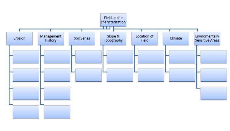
3 Demonstrate the Relevance Approximately 5 minutes Lead students through a discussion about soil quality. Consider using the following questions to help guide the discussion: Why is soil quality important? Who monitors soil quality? What factors affect soil quality? How is soil quality assessed? Provide the Experience describe the role of soil management, how climate and longitude and latitude impact soil, and identify environmentally sensitive areas Approximately 5 minutes When going to the doctor, before a diagnosis can be made patients must provide doctors with important information. Ask students what this information is called. Answer: medical history. Lead the class in a brief discussion on medical history. What is included in a medical history? Why is this important to doctors? Just as doctors need a medical history for diagnosing people, soil scientists need information about a site before recommendations can be made. Label the Information Approximately 10 minutes Instruct students to complete the graphic organizer about field or site characterization using the following information: Field or site characterization is important information for evaluating soil quality Soil series is the name of soil found in the county soil survey.
4 Signs of erosion include gullies, rills, development of pedestals, exposed areas of subsoil, wind damage or plants. Management history includes a description of past and present land and crop management; kind, amount and method of fertilization; prior tillage; and land leveling. Slope and topography includes percent slope at sampling sites and note any hills, knolls, ridges, potholes, depressions, etc. Location of field includes a record of longitude and latitude. Climatic information includes the precipitation and high and low average temperatures for each month Location of environmentally sensitive areas includes location of ponds, creeks, wetlands, or other environmentally fragile sites. Demonstrate the Relevance Approximately 10 minute As students complete their graphic organizers instruct students to complete Why is this important? bubbles on their graphic organizer. Invite students to share their responses to each of these questions with the class. Guide students through a brief discussion of site characteristics using the graphic organizers as a guide. Provide the Experience create a model and describe the causes of erosion approximately 5 minutes Ask the class to define erosion in a picture; give them a few minutes to draw their definition. After a short time, ask a few students to show their pictures. Inform students that this lesson will also allow them to take a closer look at erosion and how it affects soil quality.
5 Label the Information Approximately 10 minutes Instruct students to record the definition, causes, and characteristics of erosion. Soil erosion involves the breakdown, detachment, transport, and redistribution of soil particles by forces of water, wind, or gravity. Type of Erosion Causes Picture or Example Water Erosion Lack of protection against raindrop impact, Decreased aggregate stability, Long and steep slopes, Intense rainfall or irrigation events when plant or residue cover is at a minimum, Decreased infiltration by compaction or other means Mechanical Erosion Removal by harvest of root crops, Tillage and cultivation practices that move soil downslope. Wind Erosion Exposed surface soil during critical periods of the year, Occurrence of wind velocities that are sufficient to lift individual soil particles, Long, unsheltered, smooth soil surfaces
6 Demonstrate the Relevance time varies Provide students with the Demonstrating Erosion activity guide and review the activity and rubric. Set a due date for the activity and any parameters that are specific to your students needs and your classroom. Determine whether the activity will be completed in the classroom or as homework to be completed outside of the classroom and plan accordingly. Upon completion of the project encourage students to present their erosion model to the class. Provide the Experience Determine slope Approximately 5 minutes Set a ball on a flat surface another on an incline. Watch the ball on the incline roll down and the one on a flat surface stay put. Ask students why this happened. Look for a student to answer slope. Guide a discussion about the importance of slope in soil quality. Look for ideas such as the steepness and length of the slope influence the speed with which water runs off a field and the amount of soil carried away in the runoff water. The steepness of the slope also affects the ease of cultivation, use of farm machinery, and suitability of the site for septic tank disposal fields, homesites, playgrounds, paths, trails, golf courses, streets, and roads. Label the Information Approximately 15 minutes Instruct students to capture the slope information in their guided notes: Slope is the steepness of the land usually measure in a percentage. Draw a diagram to represent slope. Instruct students to complete the practice slope calculations in their guided notes. Review the correct answers with students to gauge their understanding.
7 Demonstrate the Relevance time varies Select an area for students to practice slope measurements. Create several sites by placing two marking flags 100 apart at each site. Encourage students to estimate the slope difference between the two flags. A 100 ft C Ground Level E 8 ft D B. Flags are 100 feet apart (A and B). From the approximate center of the 100 feet(c), step about 15 steps toward to the low side of the slope. (D)With a straight edge or using your arm extended at the ground level of (A), swing your body keeping straight edge or your arm level, locating point (E) directly above flag (B). The measurement of (E) to the ground is percent or foot of fall in elevation from (A) to (B). Note: There are several tricks to measuring slope. Consider asking an experienced land judging coach or agricultural instructor for advice and other strategies. Also, GPS devices can be helpful to accurately determine the slope of an area.
8 Provide the Experience Determine when and where to sample and discuss soil sampling guidelines Approximately 5 minutes Instruct students to work in a group of three to create a recipe for sampling soil in is important to include materials needed and specific instructions. After a few minutes, invite a few groups to share their recipes. Label the Information Approximately 10 minutes Encourage students to capture the soil sampling guidelines in their guided notes. Discuss soil samples as students record the information. When to sample? Annual sampling of a field is recommended Sample when the climate is most stable and there have been no recent disturbances such as after harvest or the end of the growing season Where to sample? Consider rows, soil type, management, plant growth, salt affected areas, erosion, slope, and drainage Select sample sites that are representative of the field For trouble spot assessment, select areas that are representative to trouble spots When comparing management systems make sure sites selected for comparison have the same soil type When making changes to soil make sure samples are taken after each change How many samples? Sample number will depend on the variability of the field Take a minimum of three samples on any one soil type
9 Demonstrate the Relevance time varies with site location Allow students to make a soil sampling plan for an area and collect samples in small groups. Show students the field that they will be using for sampling and measuring soil quality. Allow students to determine when to sample, where to sample, and how many samples to take, using the guidelines from their notes. Instruct students to visit the site and record their plan for collecting soil samples. After each group has recorded their soil sampling plan, instruct the group to justify their plan to another group. Then, allow them to collect samples. Remind students to label each sample in a plastic bag. Provide the Experience Use the Nebraska soil quality card time varies Provide each student with a copy of the Nebraska Soil Quality Card. Encourage students to use the Nebraska Soil Quality Card to evaluate the soil in the field soil sample were collected. Instruct students to work in their soil sampling groups. It is important to record field notes and carefully read the rating indicators. Note: Consider reviewing the NRCS Soils Video Soil Quality Measurement to aid in this laboratory experience. Label the Information time varies Instruct students to record their observations on the soil quality card during evaluation.
10 Demonstrate the Relevance Approximately 5 minutes When the class finishes collecting data and completing the card, lead a discussion on soil quality. Consider using the following questions to guide the discussion: Who might use the soil quality card? Why is it important for Nebraska to have its own soil quality card? What are the benefits of using the soil quality card? Do you think using this card will provide soil managers with enough information to make informed soil management decisions? What other data might soil managers need to know about a site? Review the Content Approximately 10 minutes What am I? Instruct students to create two riddles from the information in this lesson. They must present their riddle to two different partners with the partners trying to solve the riddle. Consider using the example below to help guide students. I am caused by one of the most important life sustaining substances on earth but destroy soil. What am I? Answer: Water erosion. Celebrate Student Success Approximately 3 minutes Thank students for their engagement and participation. Congratulate them on their ability to evaluate soil quality. Explain that this skill will be useful throughout their lives, if they plant a field or garden or build a house, fence, or even a swing set. Congratulate them on their ability to successfully measure slope and erosion and begin determining soil class in the land evaluation contest. Preview information in the next lesson.
11 Guided Notes: Measuring Soil Quality Notes Completed by: Characteristics of good soil Soil Quality: Assessing soil quality:
12
13 Why is this important? Management History Soil Series Signs of Erosion Slope and Topography Location of Field Climate Environmental Sensitivity
14 Erosion is Type of Erosion Causes Picture or Example
15 What is slope? Diagram slope:
16 Determine the slope percentage in each of the following problems: A. Flag 1 elevation 30 feet Flag 2 elevation 0 feet Distance 100 feet D. Flag 1 elevation 3 feet Flag 2 elevation 0 feet Distance 50 feet B. Flag 1 elevation 5 feet Flag 2 elevation 0 feet Distance 100 feet E. Flag 1 elevation 5 feet Flag 2 elevation 0 feet Distance 50 feet C. Flag 1 elevation 20 feet Flag 2 elevation 0 feet Distance 50 feet F. Flag 1 elevation 12 feet Flag 2 elevation 0 feet Distance 100 feet
17 Soil Sampling Guidelines: When to sample? Where to sample? How to sample?
18 Building A Structure : Erosion Model Student Name: Activity Due Date: Using products found around your home, construct a soil erosion model that includes all three types of soil erosion (wind, water, and mechanical). Use products that accurately represent the characteristics of each soil erosion type as discussed in class and found in the resources provided to you as well as any research you conduct on the internet or in other printed resources. Your soil profile may be a 2-D or 3-D display, edible, have movement, be stationary, or have any other creative characteristic you can imagine. The goal is that you will be able to describe each type of erosion accurately because of creating this model. The rubric below will be used for scoring this activity. CATEGORY Scientific Knowledge Plan Construction - Materials Construction - Care Taken Explanations indicate a clear and accurate understanding of scientific principles underlying the construction and modifications. Plan is neat with clear measurements and labeling for all components. Appropriate materials were selected and creatively modified in ways that made them even better. Great care taken in construction process so that the structure is neat, attractive and follows plans accurately. Explanations indicate a relatively accurate understanding of scientific principles underlying the construction and modifications. Plan is neat with clear measurements and labeling for most components. Appropriate materials were selected and there was an attempt at creative modification to make them even better. Construction was careful and accurate for the most part, but 1-2 details could have been refined for a more attractive product. Explanations indicate relatively accurate understanding of scientific principles underlying the construction and modifications. Plan provides clear measurements and labeling for most components. Appropriate materials were selected. Construction accurately followed the plans, but 3-4 details could have been refined for a more attractive product. Explanations do not illustrate much understanding of scientific principles underlying the construction and modifications. Plan does not show measurements clearly or is otherwise inadequately labeled. Inappropriate materials were selected and contributed to a product that performed poorly. Construction appears careless or haphazard. Many details need refinement for a strong or attractive product.
19 Determine the Slope KEY A. 30% B. 5% C. 40% D. 6% E. 10% F. 12%
Recommended Resources: The following resources may be useful in teaching this lesson:
 Unit E: Basic Principles of Soil Science Lesson 7: Understanding Soil Erosion and Management Practices Student Learning Objectives: Instruction in this lesson should result in students achieving the following
Unit E: Basic Principles of Soil Science. Lesson 7: Understanding Soil Erosion and Management Practices
 Unit E: Basic Principles of Soil Science Lesson 7: Understanding Soil Erosion and Management Practices 1 Important Terms Accelerated erosion Conservation tillage Cover crops Diversion ditches Geologic
Departments of Agronomy C709 Conservation Farming and Biological and Agricultural Engineering. Permanent grass cover
 Terrace Maintenance Photo 1. Measuring the ridge height above the channel is easily done with a straight board, carpenters level, and tape measure. Departments of Agronomy C709 Conservation Farming and
What in the World is a Watershed? There s a Watershed in My Backyard - Activity 1
 Soil & Water What in the World is a Watershed? There s a Watershed in My Backyard - Activity 1 Science, Geography Materials Umbrella Spray bottle with water Large bath towel Supplemental watershed diagram
Rhode Island Soil Health Worksheet
 Rhode Island Health Worksheet Client: Field: Address: Date: Indicator Worst------------------------------------------------>Best Descriptions 1 2 3 4 5 6 7 8 9 10 Poor (1-3) Fair (4-7) Excellent (8-10)
IS FALL TILLAGE FOLLOWING SOYBEAN HARVEST NECESSARY? 1/
 IS FALL TILLAGE FOLLOWING SOYBEAN HARVEST NECESSARY? / Introduction As growers look for opportunities to enhance profit margins, the need for fall tillage following soybean harvest is questioned. Although
Contents: Purpose and objective Water and energy conservation 1 1
 1 Chapter 1 Contents: 652.0100 Purpose and objective 1 1 652.0101 Water and energy conservation 1 1 652.0102 Soil conservation, water quality, and pollution abatement 1 2 652.0103 Using the guide 1 3 (a)
Understanding Soil Erosion and Management Practices
 Lesson C6 8 Understanding Soil Erosion and Management Practices Unit C. Plant and Soil Science Problem Area 6. Basic Principles of Soil Science Lesson 8. Understanding Soil Erosion and Management Practices
Erosion, Erosion, Everywhere
 Erosion, Erosion, Everywhere Main Objectives 1.Capable of describing the magnitude of accelerated soil erosion in the past and at the present. 2.Comprehend the mechanics and the factors influencing water
Soil Management for Higher Yields
 ecolo-til 2500 Soil Management for Higher Yields Great seed and great chemicals need great soil. Every plant starts out with an equal chance of producing recordsetting yields. However, the stress the plant
NATIONAL GEOGRAPHIC EDUCATOR S GUIDE
 NATIONAL GEOGRAPHIC EDUCATOR S GUIDE NEXT GENERATION SCIENCE ALIGNMENTS 1145 17th ST NW Washington, DC Visit us at www.ngchildrensbooks.org Follow us on NGKidsBks E TREME WEATHER Instructional Note The
Soil Health. National Science Teachers Association Los Angeles, California March 31, Sidney W. Davis Assistant State Soil Scientist - California
 Soil Health National Science Teachers Association Los Angeles, California March 31, 2017 Sidney W. Davis Assistant State Soil Scientist - California Zahangir Kabir Soil Health Regional Specialist- CA,
Very slight to negligible limitations no special land management practices required.
 Land Capability Classes Land and Soil Capability Class 1 Class 1 Definition Very slight to negligible limitations no special land management practices required. On-site impact of land management practices
LECTURE - 5 TILLAGE - OBJECTIVES AND TYPES. FURROW TERMINOLOGY AND METHODS OF PLOUGHING. FIELD CAPACITY AND FIELD EFFICIENCY TILLAGE Mechanical
 LECTURE - 5 TILLAGE - OBJECTIVES AND TYPES. FURROW TERMINOLOGY AND METHODS OF PLOUGHING. FIELD CAPACITY AND FIELD EFFICIENCY TILLAGE Mechanical manipulation of soil to provide favourable condition for
Erosion and Sediment Control Plan for a Timber Harvesting Operation
 3930-FM-WM0155 Rev. 7/2004 Erosion and Sediment Control Plan for a Timber Harvesting Operation 1. GENERAL INFORMATION A. Location Municipality B. Timber sale area = acres Date County C. Landowner Name
Soil Properties that influence detachment and runoff
 Soil Properties that influence detachment and runoff Texture Structure Aggregation Density/compaction Wettability Antecedent soil moisture Organic Matter Sandy soils Sands are easily detacted However,
SOIL QUALITY AND CROP PRODUCTION. Dick Wolkowski Department of Soil Science University of Wisconsin
 SOIL QUALITY AND CROP PRODUCTION Dick Wolkowski Department of Soil Science University of Wisconsin WHAT IS SOIL QUALITY DEPENDS ON WHO YOU ARE: Farmer: Highly productive, sustainable media for growing
Study Questions Exam 5
 Study Questions Exam 5 1. List three best management practices intended to reduce the loss of nutrients from agroecosystems. No problem. 2. Explain how buffer strips work. Runoff enters at higher velocity,
33. Fate of pesticides in soil and plant.
 33. Fate of pesticides in soil and plant. What Happens to Pesticides When a pesticide is released into the environment many things happen to it. Sometimes what happens is beneficial. For example, the leaching
When it Rains it Pours
 Lesson Summary: Students will understand how water is absorbed into the ground. They will also be able to explain the difference between pervious and impervious surfaces. Students will also learn about
Soil and farm practices data concerning the case study Svratka were collected according to questionnaire 1 by the expert on soil protection.
 Soil and farm practices data concerning the case study Svratka were collected according to questionnaire 1 by the expert on soil protection. Farmers in the case study region were interviewed according
Antonio Mallarino Professor, Department of Agronomy. Introduction
 2003 Integrated Crop Management Conference - Iowa State University 121 USING THE IOWA PHOSPHORUS INDEX FOR AGRONOMIC AND ENVIRONMENTAL MANAGEMENT OF FERTILIZER AND MANURE PHOSPHORUS Antonio Mallarino Professor,
Land Use Activities Potential Pollution Problems. Land Disposal septic system bacteria, nitrate, phosphate
 If Bugs Could Talk PURPOSE: To describe and identify the link between land use activities within a watershed and water quality. Students will also understand the link between aquatic macroinvertebrates
Of vital importance..
 Soil moisture Of vital importance.. Low and erratic rainfall form a significant cause of low crop production and crop failure in rainfed agriculture in the tropics However, crop and land management do
Streamlines V2, n2 (May 1997) A Newsletter for North Carolina Water Supply Watershed Administrators
 A Newsletter for North Carolina Water Supply Watershed Administrators") Page 1 of 5 STREAMLINES A Newsletter for North Carolina Water Supply Watershed Administrators Volume 2, Number 2 May 1997 Non-Point Source (NPS) Pollution This issue of Streamlines provides basic information
Page 1 of 5 STREAMLINES A Newsletter for North Carolina Water Supply Watershed Administrators Volume 2, Number 2 May 1997 Non-Point Source (NPS) Pollution This issue of Streamlines provides basic information
INSTRUCTIONS FOR SUBMITTING A COMMERCIAL SEWAGE DISPOSAL PERMIT APPLICATION
 Permits will be processed only when ALL required information is provided Application MUST be accompanied by the following: Property address or road location with distance from nearest intersection. IT
GIS Analysis of Gully Head Erosion Rates on High Ridge Tree Farm in Winona County, Minnesota
 GIS Analysis of Gully Head Erosion Rates on High Ridge Tree Farm in Winona County, Minnesota Lisa M. Worrell Department of Resource Analysis, Saint Mary s University of Minnesota, Winona, MN 55987. Keywords:
Nancy L. Young, Forester USAID/USDA Natural Resources Conservation Service
 Forest Management Nancy L. Young, Forester USAID/USDA Natural Resources Conservation Service Material translated by: Mohammadullah Karimi, Training & Liaison Officer Afghan Conservation Corps Managing
Monitoring Soil Nutrients in Dryland Systems Using Management Units
 EM 8920-E November 2006 Monitoring Soil Nutrients in Dryland Systems Using Management Units M.K. Corp, D.A. Horneck, D. Wysocki, and L. Lutcher The use of management units for soil testing and nutrient
New Castle County, DE. Floodplain Regulations
 New Castle County, DE Floodplain Regulations John J. Gysling, PE CFM Department of Land Use New Castle County, DE February 26, 2009 Today s Presentation Floodplain Protection and Uses Terms and Definitions
Regulatory Guidance Letter 96-02
 Regulatory Guidance Letter 96-02 SUBJECT: Applicability of Exemptions under Section 404(f) to "Deep-Ripping" Activities in Wetlands DATE: 12 December 1996 EXPIRES: 31 December 2001 Department of the Army,
Nutrient Management in. A presentation to the West Metro Water Alliance
 Nutrient Management in Developing and Agricultural Areas A presentation to the West Metro Water Alliance Chris Meehan, P.E. May 25, 2011 Agenda Physical Improvements Planning Improvements How to get it
CHAPTER 6 ADDITIONAL STANDARDS APPLYING TO SHORELAND AREAS AND PUBLIC WATERS
 CHAPTER 6 ADDITIONAL STANDARDS APPLYING TO SHORELAND AREAS AND PUBLIC WATERS Section 1 Intent. 49 Section 2 Floodplain Requirements 49 Section 3 Water-Oriented Accessory Structures 50 Section 4 Stairways,
TURF-TEC 6 and 12 INCH INFILTRATION RINGS INSTRUCTIONS (IN7-W & IN8-W)
") TURF-TEC 6 and 12 INCH INFILTRATION RINGS INSTRUCTIONS (IN7-W & IN8-W) Outline of Uses The Turf-Tec Infiltration Rings was specifically designed to give infiltration readings directly on site. It can give
TURF-TEC 6 and 12 INCH INFILTRATION RINGS INSTRUCTIONS (IN7-W & IN8-W) Outline of Uses The Turf-Tec Infiltration Rings was specifically designed to give infiltration readings directly on site. It can give
Flood Plain Functions
 Flood Plain Functions Lesson Abstract Summary: MO GLE: Subject Areas: Students will connect knowledge from previous watershed lessons to understand the functions of flood plains by participating in group
GOAL STATEMENT: Students will learn about soil as a natural resource, what its components are, how it is used, and whether it is renewable.
 STATE SCIENCE STANDARDS: 6 th, 7 th, 8 th Grade Skills and Processes 1.0.A.1.h Use mathematics to interpret and communicate data. 1.0.B.1 Review data from a simple experiment, summarize the data, and construct
Soil Degradation. Lesson Plan NRES B2-9
 Soil Degradation Lesson Plan NRES B2-9 Objectives 1. What is soil degradation? 2. How can construction result in soil degradation? 3. What are the sources of contamination, and how do they result in soil
Estimating Field-Scale Runoff and Sediment Delivery. Seth M. Dabney, USDA-ARS Dalmo A. N. Vieira, USDA-ARS Daniel C. Yoder, Univ.
 Estimating Field-Scale Runoff and Sediment Delivery Seth M. Dabney, USDA-ARS Dalmo A. N. Vieira, USDA-ARS Daniel C. Yoder, Univ. of Tennessee Organization Buffers for concentrated flow control Distributed
Saturated Buffer. Subsurface Drainage PURPOSE N REDUCTION LOCATION COST BARRIERS
 Saturated Buffer To intercept tile drainage prior to discharging to surface waters and redistribute the water laterally in the soil profile of the streamside buffer. Subsurface drainage, also known as
Erosion & Sedimentation Control Policy
 Issue Date 10/22/2010 Page 1 of 8 Erosion & Sedimentation Control Policy Introduction: Soil erosion is the removal of soil by water, wind, ice or gravity and sediment deposition occurs when the rate of
Soil structure and Field Traffic Management. Tim Chamen CTF Europe
 Soil structure and Field Traffic Management Tim Chamen CTF Europe What are the physics of a good soil structure? A diverse mix of solids, air and water with a continuous network of pores that allow free
Overall Instructions
 Farm Evaluation Survey Overall Instructions This Farm Evaluation Survey is prepopulated with member information you provide to the Coalition. If any information is incorrect, please indicate the correct
Conservation Practices for Water Quality: Sediment & Nutrient Control. Trap Sediments/Trap Nutrients on the Field. Improve Soil Health.
 Conservation Practices for Water Quality: Sediment & Nutrient Control. Trap Sediments/Trap Nutrients on the Field. Improve Soil Health. Sediment Conservation Cover Cover Crop Critical Area Planting Field
Grassed Waterway Improvement and Gully Restoration
 Revised April 2007 Agdex 573-5 Grassed Waterway Improvement and Gully Restoration Each year, tonnes of topsoil are eroded from localized areas on some Alberta farms. This loss is serious for several reasons:
Precipitation Surface Cover Topography Soil Properties
 Precipitation Surface Cover Topography Soil Properties Intrinsic capacity of rainfall to cause erosion Influenced by Amount, intensity, terminal velocity, drop size and drop size distribution of rain.
Welcome to Parent Information Night
 Welcome to Parent Information Night Ridgecrest School Science Fair Dates: January 28 th project set up January 29 th judging January 30 th parent viewing night District Science Showcase will be in May!
G Estimating Percent Residue Cover Using the Calculation Method
 University of Nebraska - Lincoln DigitalCommons@University of Nebraska - Lincoln Historical Materials from University of Nebraska- Lincoln Extension Extension 1995 G95-1135 Estimating Percent Residue Cover
Trials and Tribulations of Building a New Sports Field Complex. Roger D. Havlak *Parks Superintendent (City of San Angelo) *Turfgrass Consultant
 *Turfgrass Consultant") Trials and Tribulations of Building a New Sports Field Complex Roger D. Havlak *Parks Superintendent (City of San Angelo) *Turfgrass Consultant Rio Concho Sports Complex Construction began September 2007
Trials and Tribulations of Building a New Sports Field Complex Roger D. Havlak *Parks Superintendent (City of San Angelo) *Turfgrass Consultant Rio Concho Sports Complex Construction began September 2007
Who cares? You do! In India, one child dies every minute from severe acute malnutrition.
 Soil & Agriculture Who cares? You do! In India, one child dies every minute from severe acute malnutrition. Case Study: The Dust Bowl In the dirty thirties a large area of cropland was abandoned due to
CHAPTER 4 SOIL MANAGEMENT
 California Wine Community Sustainability Report 2009 Soil Management Chapter 4 CHAPTER 4 SOIL MANAGEMENT 37 Background Benchmark Data Healthy soil is the foundation of a sustainable vineyard. A third of
Division of Surface Water
 John R. Kasich, Governor Mary Taylor, Lt. Governor Craig W. Butler, Director Division of Surface Water Instructions for Completing and Submitting an Application for Authorization: Class B Beneficial Use
APPENDIX F. Soil Sampling Programs
 166 Soil Sampling Programs Soil sampling for laboratory analysis is the only way to determine the levels of plant nutrients in a field and obtain fertilizer recommendations for that field It is also required
BUILDING A WATERSHED MODEL
 BUILDING A WATERSHED MODEL OBJECTIVES Define a watershed and describe how it functions Identify that students live in a watershed within the San Antonio River Basin TOPICS Watersheds Runoff TEKS ALIGNMENT
Conservation Practices. Conservation Choices. These five icons will show the benefits each practice offers... 6/4/2014
 Conservation Choices Your guide to conservation and environmental farming practices. Conservation Choices These five icons will show the benefits each practice offers... The practice reduces soil erosion
Unit E: Basic Principles of Soil Science. Lesson 8: Employing Conservation Tillage Practices
 Unit E: Basic Principles of Soil Science Lesson 8: Employing Conservation Tillage Practices 1 Terms Conservation tillage Continuous cropping Conventional tillage Crop rotation Double cropping Organic farming
Manure Storage for Environmental Management Systems
 WiMStor01 MStor Manure Storage for Environmental Management Systems Key: 1)Low Risk 2)Low-Moderate Risk 3)Moderate-High Risk 4)High Risk Location of Manure Storage Are the manure storage facilities in
Stubble Mulch Judging : Extension Circular
 University of Nebraska - Lincoln igitalcommons@university of Nebraska - Lincoln Nebraska 4-H Clubs: Historical Materials and Publications 4-H Youth evelopment 4-1958 Stubble Mulch Judging : Extension Circular
CHAPTER 2 EROSION CONTROL
 CHAPTER 2 EROSION CONTROL 2.1 EROSION AND EROSION CONTROL Understanding Erosion Erosion occurs when soil particles are detached from the land surface and carried downslope by moving water. Figure 2.1-1
What is a Watershed? Lesson 2 Objectives Materials Background Advance Preparation Procedure
 What is a Watershed? Lesson 2 --------------------------------------------------------------------------------------------------------------------------- Objectives The student will be able to do the following:
Step-by-Step Instructions for Lesson and Materials List
 Step-by-Step Instructions for Lesson and Materials List Materials: Modeling clay (beige, terra cotta, dark brown, green) 1 - Roll the beige, dark brown, and green modeling clay into flat layers using a
Best Management Practices (BMPs) are structural
 are structural") Agriculture and Natural Resources WATER QUALITY: Controlling Nonpoint Source (NPS) Pollution A L A B A M A A & M A N D A U B U R N U N I V E R S I T I E S ANR-790-4.2.3 The Rural Environment And NPS Pollution
Agriculture and Natural Resources WATER QUALITY: Controlling Nonpoint Source (NPS) Pollution A L A B A M A A & M A N D A U B U R N U N I V E R S I T I E S ANR-790-4.2.3 The Rural Environment And NPS Pollution
Ponds. Pond A water impoundment made by excavating a pit, or constructing a dam or an embankment.
 POND SITE SELECTION AND CONSTRUCTION Uses, Planning, & Design David Krietemeyer Area Engineer USDA-NRCS June 20, 2008 Uses Considerations for Location of Commonly Used Terms Pond A water impoundment made
Building a Watershed Model
 9 Building a Watershed Model Purpose Students will build a model to identify the characteristics of a watershed. Students will learn how elevation determines the flow of water within a watershed. Overview
Lift irrigation Using man or Animal power Using Mechanical or Electrical Power Flow irrigation a)inundation Irrigation b) Perennial Irrigation Direct
inundation Irrigation b) Perennial Irrigation Direct") Lift irrigation Using man or Animal power Using Mechanical or Electrical Power Flow irrigation a)inundation Irrigation b) Perennial Irrigation Direct irrigation Storage irrigation a)flow irrigation system:
Lift irrigation Using man or Animal power Using Mechanical or Electrical Power Flow irrigation a)inundation Irrigation b) Perennial Irrigation Direct irrigation Storage irrigation a)flow irrigation system:
VIRGINIA POLLUTION ABATEMENT PERMIT APPLICATION
 VIRGINIA POLLUTION ABATEMENT PERMIT APPLICATION FORM B ANIMAL WASTE Department of Environmental Quality VPA FORM B ANIMAL WASTE INSTRUCTIONS This form is to be completed by applicants requesting a VPA
East Maui Watershed Partnership Adapted from Utah State University and University of Wisconsin Ground Water Project Ages 7 th -Adult
 INTRODUCTION What is groundwater? Water contained in saturated soil and rock materials below the surface of the earth. It is not NEW water, but is recycled water through the hydraulic cycle. The source
VIRGINIA POLLUTION ABATEMENT (VPA) PERMIT APPLICATION. FORM B - ANIMAL FEEDING OPERATIONS (AFOs)
 PERMIT APPLICATION. FORM B - ANIMAL FEEDING OPERATIONS (AFOs)") VIRGINIA POLLUTION ABATEMENT (VPA) PERMIT APPLICATION FORM B - ANIMAL FEEDING OPERATIONS (AFOs) Department of Environmental Quality Rev. 02-2013 VIRGINIA POLLUTION ABATEMENT (VPA) PERMIT APPLICATION FORM
VIRGINIA POLLUTION ABATEMENT (VPA) PERMIT APPLICATION FORM B - ANIMAL FEEDING OPERATIONS (AFOs) Department of Environmental Quality Rev. 02-2013 VIRGINIA POLLUTION ABATEMENT (VPA) PERMIT APPLICATION FORM
TECHNICAL CONTENT PROPOSED STEEP SLOPE REGULATION
 1 TECHNICAL CONTENT PROPOSED STEEP SLOPE REGULATION Draft 2/08/10 (Revised 02-14-11,Revised 02-21-11, Revised 03-03-11, Revised 04-19-11, Revised 04-20-11, Revised 05-05-11, Revised 05-09-11). DEFINITIONS
Teacher Resources: Lesson 3: Groundwater. Lesson #3: Groundwater
 Teacher Resources: Lesson 3: Groundwater Lesson #3: Groundwater Main Ideas: Accounts (From the Water Upper Anchor V. 3) Structure of Systems: Water usually exists underground in the liquid state. Macroscopic
Best Management Practice (BMP) Guidance Manual
 Guidance Manual") Best Management Practice (BMP) Guidance Manual INTRODUCTION BMP examples in this guide provide ways to meet erosion and sediment control requirements. Best Management Practices are not limited to these
Best Management Practice (BMP) Guidance Manual INTRODUCTION BMP examples in this guide provide ways to meet erosion and sediment control requirements. Best Management Practices are not limited to these
Runoff Volume: The Importance of Land Cover
 Runoff Volume: The Importance of Land Cover Grade Level: 9-12 Time: 1-2 class periods Learning Objectives: - Quantify the volume of water that runs off different land uses in a watershed. - Analyze the
Soil Quality How can we improve soil quality?
 Activitydevelop Soil Quality How can we improve soil quality? Overview Students explore the conditions that make high-quality soils. Using data from field research and interactive computational models,
Sherman Library Maintenance Handbook for Porous Asphalt
 Sherman Library Maintenance Handbook for Porous Asphalt Porous asphalt systems are an effective means of stormwater management. Unlike traditional pavements, rainfall drains through the pavement surface
IS SOIL COMPACTION FROM ANIMAL TRAFFIC A PROBLEM IN PASTURES DICK WOLKOWSKI EXTENSION SOIL SCIENTIST UNIVERSITY OF WISCONSIN
 IS SOIL COMPACTION FROM ANIMAL TRAFFIC A PROBLEM IN PASTURES DICK WOLKOWSKI EXTENSION SOIL SCIENTIST UNIVERSITY OF WISCONSIN SOIL COMPACTION DEFINED Compression of the soil from an applied force that first
did you know? Biomass is the most widely used renewable energy source in the world.
 Section 1: Gathering Information Biomass Basics Web-quest Summary Students access various Web sites and complete the Web-quest Exploration Guide to learn about biomass and bioenergy, including sources,
Watershed BMPs. Notes from NRCS online site on BMPs. Focus on key BMPs
 Notes from NRCS online site on BMPs http://www.nrcs.usda.gov/technical/standards/nhcp.html Focus on key BMPs Function, benefits, and drawbacks listed Definition Novotny & Olem: BMPs are methods and practices
Mississippi River Basin Healthy Watershed Initiative
 Mississippi River Basin Healthy Watershed Initiative A Progress Report for Arkansas Presented by: Mike Sullivan, State Conservationist FY 2010 12 States 41 Focus Areas FY 2011 Added two focus areas: SD/MS
NUTRIENT MANAGEMENT (ac.) CODE 590
 CODE 590") IG-590-1 NATURAL RESOURCES CONSERVATION SERVICE CONSERVATION PRACTICE INSTALLATION GUIDELINES NUTRIENT MANAGEMENT (ac.) CODE 590 GUIDELINES APPLICABLE FOR ALL PURPOSES Nutrient management activities shall
IG-590-1 NATURAL RESOURCES CONSERVATION SERVICE CONSERVATION PRACTICE INSTALLATION GUIDELINES NUTRIENT MANAGEMENT (ac.) CODE 590 GUIDELINES APPLICABLE FOR ALL PURPOSES Nutrient management activities shall
SERVATION Focus Questions: What is a watershed? How do we manage it to make sure our water is clean and plentiful?
 Thank you for participating in the Arizona Water Festival program! Our program assessment shows that students who experience the entire Water Festival unit, from pre-lessons to post-lessons, get far more
DRAFT USER S REFERENCE GUIDE
 DRAFT USER S REFERENCE GUIDE Revised Universal Soil Loss Equation Version 2 (RUSLE2) Prepared for USDA-Agricultural Research Service Washington, D.C. May 15, 2008 2 Acknowledgements RUSLE2 was developed
CITY OF SPRING HILL Water Quality Buffer Zone Policy (Adopted April 22, 2008)
") Section I - Description CITY OF SPRING HILL Water Quality Buffer Zone Policy (Adopted April 22, 2008) A water quality buffer zone (a.k.a. a riparian zone) is a strip of undisturbed native (indigenous)
Section I - Description CITY OF SPRING HILL Water Quality Buffer Zone Policy (Adopted April 22, 2008) A water quality buffer zone (a.k.a. a riparian zone) is a strip of undisturbed native (indigenous)
LOT GRADING. LOT GRADING REQUIREMENTS The following lot grading requirements came into effect on May 1, 2007:
 LOT GRADING DEFINITION Lot grading is the reshaping or sloping of the land in such a way that surface drainage from rain runoff is directed away from the buildings and is controlled in a manner that eliminates
Conservation Tillage Systems for Spring Corn in the Semihumid to Arid Areas of China
 This paper was peer-reviewed for scientific content. Pages 366-370. In: D.E. Stott, R.H. Mohtar and G.C. Steinhardt (eds). 2001. Sustaining the Global Farm. Selected papers from the 10th International
Soil Treats, Gaps, and Technical Assessment. Agricultural University of Athens Costas Kosmas
 Soil Treats, Gaps, and Technical Assessment Agricultural University of Athens Costas Kosmas Identified important threats to European soils The European Commission adopted a Soil Thematic Strategy (COM(2006)
Standards for Soil Erosion and Sediment Control in New Jersey May 2012 STANDARD FOR SLOPE PROTECTION STRUCTURES. Definition
 STANDARD FOR SLOPE PROTECTION STRUCTURES Definition Structures to safely conduct surface runoff from the top of a slope to the bottom of the slope. Purpose The purpose of this practice is to convey storm
Straw Bale Barrier. - Along the face and at grade breaks of exposed and erodible slopes to shorten slope length and spread runoff as sheet flow
 Straw Bale Barrier SE-9 Objectives EC Erosion Control SE Sediment Control TR Tracking Control WE Wind Erosion Control Non-Stormwater NS Management Control Waste Management and WM Materials Pollution Control
Lesson 1: Energy and Power
 Student Name: Unit 5: Design Lesson 1: Energy and Power File 5.1.3: Wind Power Design Brief Background: You and your friends wish to build a club house in a secluded spot with no electricity. The group
Jacobi, Toombs, and Lanz, Inc.
 Area 5: Blackiston Mill Road at Dead Man's Hollow Flooding Assessment Jacobi, Toombs, and Lanz, Inc. This document summarizes an assessment of drainage and flooding concerns and provides recommendations
Land Application and Nutrient Management
 MODULE D Land Application and Nutrient Management Figure 34-13. Relationship between the concentration of dissolved P in subsurface drainage from 30 cm deep lysimeters and the Mehlich-3 extractable soil
Erosion and Sediment Pollution Control Guidelines for Residential Lots with soil disturbance of less than 1 acre (see exceptions)
") Adams Co. Conservation District 670 Old Harrisburg Road, Suite 201 Gettysburg, PA 17325 Telephone: 334-0636 Fax: 337-0730 www.adamscounty.us Erosion and Sediment Pollution Control Guidelines for Residential
Adams Co. Conservation District 670 Old Harrisburg Road, Suite 201 Gettysburg, PA 17325 Telephone: 334-0636 Fax: 337-0730 www.adamscounty.us Erosion and Sediment Pollution Control Guidelines for Residential
Soil Quality and Crop Production Systems. Dick Wolkowski Extension Soil Scientist
 November 2005 Issue #2 2005 Soil Quality and Crop Production Systems Dick Wolkowski Extension Soil Scientist Soil quality is a general term that describes the overall condition of the soil with respect
Bench terraces on loess soil China - 土坎梯田, 梯地
 Bench terraces on loess soil China - 土坎梯田, 梯地 A Terrace is a structural SLM practice with a raised flat platform built on the slope to reduce soil loss and runoff on the slope, increase the rainfall infiltration
INVESTIGATION: Flour vs. Bread: How Soil Aggregate Structure Influences Water Flows. Time: minutes, depending on the amount of discussion.
 INVESTIGATION: Flour vs. Bread: How Soil Aggregate Structure Influences Water Flows Time: 15-60 minutes, depending on the amount of discussion. Grade Level: appropriate for any age. Summary: If I only
Science Physical Science Grades 6 and 8
 Science Physical Science Grades 6 and 8 Subject: Physical Science: Thermal Energy Level: Grade 6 and 8 The Hot in the Cold Abstract: Students will conduct an experiment and collect data on the exchange
Biomes and Biodiversity Power Point Notes
 Name period date assigned date due date returned Biomes and Biodiversity Power Point Notes 1. One teacher is to as all teachers is to. 2. Teachers and students are to as George West is to. Vocabulary Word
The Hydrologic Cycle. Floods 3 5. Flood Science LESSON PLAN 1. Key Terms and Concepts. Purposes. Objectives
 LESSON PLAN 1 The Hydrologic Cycle Floods It is important for children to understand the hydrologic cycle in preparation for learning the science behind floods and flash floods. Key Terms and Concepts
HOW TO INSTALL PATIOS AND WALKWAYS STEP 2 STEP 1. For all Patios and Walkways. The base is the most important step in your patio and walkway projects.
 New Project (replacing grass/dirt) STEP 1 PREPARING YOUR PROJECT AREA Determine how much to excavate using the example below. Remove the grass to desired depth (skim rather than dig deep) and a few inches
Tree Trails. Benefits and Values of Trees
 TREE TRAILS Tree Trails 5 ELEMENTARY Benefits and Values of Trees Advances in the science of urban forestry allow us to assign monetary values to a wide range of benefits that trees in urban areas provide.