Prairie Pothole Wetlands: Characteristics, Functions, and Values
|
|
|
- Gwen Horn
- 6 years ago
- Views:
Transcription


1 Prairie Pothole Wetlands: Characteristics, Functions, and Values Brian Tangen USGS, Northern Prairie Wildlife Research Center U.S. Department of the Interior U.S. Geological Survey Society for Range Management Annual Meeting Billings, Mt., 6-10 February, 2011

2 Outline I. Prairie Pothole Region (PPR) II. PPR wetlands III. Important concepts and processes IV.Ecosystem services & values

3 Prairie Pothole Region (PPR)
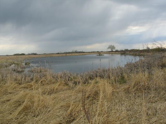
4 PPR wetlands Small depressional wetlands often called potholes or sloughs Formed by glacial activity Large proportion <1 ha Classification systems: Stewart and Kantrud 1971, Cowardin et al. 1979, Brinson 1993 NWI palustrine emergent with temporary, seasonal, & semipermanent water regimes Classification can vary

5 PPR Photo provided by the U.S. Fish and Wildlife Service

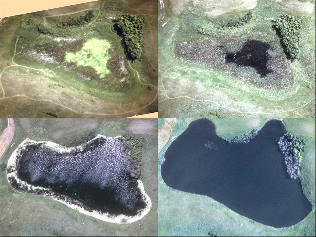
6 Many faces

7 Conservation 35-90% loss across the region High priority for conservation USDA restoration programs CRP WRP


8 Important processes and concepts Catchment Water balance Hydrology & climate
9 Wetland catchment Upland zone Wetland zone
10 Wetland catchment Important concept because wetland functions are highly influenced by surrounding uplands Land use / land cover Soils Slopes Precipitation runoff Sedimentation Nutrients / agrichemicals Waterfowl nesting habitat
11 Catchment water-balance ET Near-surface runoff Seepage Surface runoff ET Direct precipitation Surface overflow Groundwater
12 Hydrology Majority of functions / processes influenced by hydrology Hydroperiod Highly variable (climate, wetland class) Intra-annual and interannual Nutrient cycling, productivity, composition of biotic communities Groundwater relations Recharge, flow-through, discharge Water permanence, chemistry, biotic communities
13


14 Past and current research Waterfowl Hydrology / groundwater Vegetation Soils Ecosystem services Modeling Hydrology Vegetation dynamics Land-use impacts
15 Ecosystem services Ecosystem services: the benefits people obtain from ecosystems (Millennium Ecosystem Assessment 2005) The concept of ecosystem services is inherently based on the value or importance to humans, but the expression of those services is controlled by the underlying complex eco logical structure and processes (Zhu et al. 2010) 4 main categories: Supporting (e.g., soil formation) Regulating (e.g., carbon sequestration/climate change) Provisioning (e.g., food and fiber) Cultural (e.g., recreation and education)
16 Functions / values of PPR wetlands 1. Waterfowl & wildlife habitat 2. Floodwater storage 3. Groundwater recharge 4. Biodiversity 5. Recreational opportunities 6. Water quality 7. Mitigation of atmospheric CO 2 8. Forage / water for livestock

17 Waterfowl & wildlife habitat Nesting habitat Food resources Brood rearing Migration stopover Sanctuary from predators Winter cover

18 Wetland complexes

 on downstream")
19 Floodwater storage Wetland drainage / land-use change linked to increased intensity and frequency of flooding Research: Flood-storage capacity of wetlands Impact of wetland storage (or loss of storage) on downstream flooding
20 Floodwater storage Wetlands in the Devils Lake basin of North Dakota could store approximately 72 and 41% of the total runoff volume from a 2-year and 100-year frequency runoff event (Ludden et al. 1983) Vining (2002) reported that pothole wetlands in the Starkweather Coulee subbasin of Devils Lake, ND were capable of storing more than 8,000 ha-m A complex of wetlands retained all local runoff plus 58% of additional inflow (Malcolm 1979) Restoring drained and farmed wetlands could increase the water retention capacity of a PPR watershed by up to 63% (Gleason and others 2007) Modeling the downstream impact?

21 Groundwater recharge PPR wetlands have various relations to groundwater Many recharge groundwater Slow process Difficult to quantify Pumping for irrigation

22 Biodiversity Native plants Birds Amphibians Invertebrates

23 Floristic quality Laubhan and Gleason 2008


24 Recreational opportunities Hunting Bird watching Photography Education
25 Water quality Wetlands can act as filters Intercept runoff Retain excess nutrients and some pollutants Reduce sediment that could clog lotic waterways and affect aquatic communities This is a benefit for downstream systems; but, is it a benefit for the wetland?

26 Mitigation of atmospheric CO 2 Climate change and elevated CO 2 Soil carbon GHG s CH 4 N 2 O CO 2 Net benefit?
27 Soil carbon and GHGs Carbon sequestration High productivity Great potential Highly variable Climate Soils Land use GHGs CH 4, N 2 O Highly variable Climate Precipitation Temperature Hydrology Soil moisture Soil NO 3 Land use
28 Soil carbon Gleason et al. 2008
29 GHGs

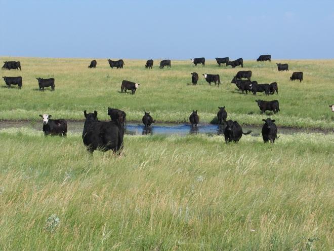

30 Forage & water for livestock

31 Summary PPR wetlands Concepts Processes Ecosystem services Functions & values
32 Questions?
Estimating Water Storage Capacity of Existing and Potentially Restorable Wetland Depressions in a Subbasin of the Red River of the North
 University of Nebraska - Lincoln DigitalCommons@University of Nebraska - Lincoln USGS Northern Prairie Wildlife Research Center Wildlife Damage Management, Internet Center for 007 Estimating Water Storage
Maitland Valley WATERSHED
 Maitland Valley WATERSHED Report Card 2018 Maitland Conservation has prepared this report card as a summary of the state of your forests, wetlands, and water resources. WHERE ARE WE? We are one of 36 Conservation
VIDEO: Riparian Forest Buffers: The Link Between Land & Water
 VIDEO: Riparian Forest Buffers: The Link Between Land & Water Introduction to Riparian Buffers Adapted from: Riparian Forest Buffers: The Link Between Land & Water. Maryland Cooperative Extension. Wye
Lowland Forages. Recycling Plant Nutrients
 Lowland Forages Recycling Plant Nutrients Lowland Forages Lowland forage species provide excellent hay when harvested at the peak of quality in early July. Feed value drops quickly to what is commonly
WATERSHED. Maitland Valley. Report Card 201
 Maitland Valley WATERSHED Report Card 201 The Maitland Valley Conservation Authority has prepared this report card as a summary on the state of our forests, wetlands, surface water, and ground water resources.
Conservation Practices. Conservation Choices. These five icons will show the benefits each practice offers... 6/4/2014
 Conservation Choices Your guide to conservation and environmental farming practices. Conservation Choices These five icons will show the benefits each practice offers... The practice reduces soil erosion
Afternoon Lecture Outline. Northern Prairie Hydrology
 Afternoon Lecture Outline 1. Northern Prairies watershed hydrology 2. Solute mass balance in lakes and ponds 3. Simple mass balance simulation using MS Excel 4. Effects of sediment-water exchange on lake
New Investments in Water Portfolios
 California Water Plan Update 2010 New Investments in Water Portfolios California Water and Environmental Water Forum Annual Meeting February 27, 2007 Todd Hillaire hillaire@water.ca.gov California Department
Design Features of Constructed Wetlands for Nonpoint Source Treatment. September 1995
 Design Features of Constructed Wetlands for Nonpoint Source Treatment September 1995 Brochure written by William W. Jones, School of Public and Environmental Affairs, Indiana University, Bloomington, Indiana.
3/1/18 USING RADAR FOR WETLAND MAPPING IMPORTANCE OF SOIL MOISTURE TRADITIONAL METHODS TO MEASURE SOIL MOISTURE. Feel method Electrical resistance
 3/1/18 USING RADAR FOR WETLAND MAPPING SOIL MOISTURE AND WETLAND CLASSIFICATION Slides modified from a presentation by Charlotte Gabrielsen for this class. Southeast Arizona: Winter wet period From C.
Afternoon Lecture Outline
 Afternoon Lecture Outline 1. Northern Prairies watershed hydrology 2. Solute mass balance in lakes and ponds 3. Simple mass balance simulation using MS Excel 4. Effects of sediment-water exchange on lake
Will be modified map from GIS 6/16 EOD
 Middle-Snake-Tamarac Rivers Watershed District Judicial Ditch #19 Watershed Regional Conservation Partnership Program (RCPP) Public Scoping Meeting September 26, 2016 Will be modified map from GIS 6/16
Otonabee Region WATERSHED
 Otonabee Region WATERSHED Report Card 2018 Otonabee Conservation has prepared this report card as a summary of the state of your forests, wetlands, and water resources using data from 2012 to 2016. WHERE
Natural and Engineered Wetlands for Stormwater Management
 Natural and Engineered Wetlands for Stormwater Management Dan Hitchcock, Ph.D., P. E. Baruch Institute of Coastal Ecology and Forest Science Clemson University Georgetown, SC Prominence and Diversity of
Wetlands in Alberta: Challenges and Opportunities. David Locky, PhD, PWS, PBiol Grant MacEwan University
 Wetlands in Alberta: Challenges and Opportunities David Locky, PhD, PWS, PBiol Grant MacEwan University Overview What & Where Function & Value Alberta s Keystone Ecosystem Losses & Impacts Restoration
Ponds. Pond A water impoundment made by excavating a pit, or constructing a dam or an embankment.
 POND SITE SELECTION AND CONSTRUCTION Uses, Planning, & Design David Krietemeyer Area Engineer USDA-NRCS June 20, 2008 Uses Considerations for Location of Commonly Used Terms Pond A water impoundment made
Chapter 10 Natural Environment
 Chapter 10 Natural Environment Existing Conditions The Natural Environment Element addresses the protection, conservation, preservation, and restoration of the natural resources the Bayview Ridge Subarea,
ANALYSIS OF CCRP S RECORD BREAKING ENROLLMENT NSAC SPECIAL REPORTS
 ANALYSIS OF CCRP S RECORD BREAKING ENROLLMENT NSAC SPECIAL REPORTS FEBRUARY 217 KEYWORDS AND PROGRAMS: CONSERVATION RESERVE PROGRAM, CONTINUOUS CONSERVATION RESERVE PROGRAM, CONSERVATION RESERVE ENHANCEMENT
WATER AND THE HYDROLOGIC CYCLE
 WATER AND THE HYDROLOGIC CYCLE Summary Water is essential for the support of life and can be considered as a fundamental environmental good. Water is needed to support human habitation, grow crops and
Promoting PES in the Danube Basin
 Promoting PES in the Danube Basin Fostering PES projects in CEE and NIS Training Seminar, December 7-9 2006, Isle of Vilm Yanka Kazakova WWF Danube Carpathian Programme The Danube The most international
Wetlands Project Guidance
 HABITAT Wetlands Project Guidance Stakeholder Informed Introduction Wetlands are lands saturated with water permanently or seasonally. Wetlands are typically defined by three characteristics: 1) The area
Lecture 1 Integrated water resources management and wetlands
 Wetlands and Poverty Reduction Project (WPRP) Training module on Wetlands and Water Resources Management Lecture 1 Integrated water resources management and wetlands 1 Water resources and use The hydrological
POLICY FOR NATURAL RESOURCE MANAGEMENT AREAS
 POLICY FOR NATURAL RESOURCE MANAGEMENT AREAS I. POLICY STATEMENT Auburn University's (the University's) "Policy for Natural Resource Management Areas" implements the Campus Master Plan Land Use Element
Conservation Practices for Water Quality: Sediment & Nutrient Control. Trap Sediments/Trap Nutrients on the Field. Improve Soil Health.
 Conservation Practices for Water Quality: Sediment & Nutrient Control. Trap Sediments/Trap Nutrients on the Field. Improve Soil Health. Sediment Conservation Cover Cover Crop Critical Area Planting Field
Appendix J. Existing Efforts for Identifying Multi-Benefit Projects
 Appendix J Existing Efforts for Identifying Multi-Benefit Projects Water Purveyor Projects Existing Efforts for Identifying Multi Benefits Projects In-lieu groundwater recharge under RWA planning efforts
Ditches in North Carolina
 Ditches in North Carolina Raleigh Bland Regulatory Project Manager Washington Regulatory Field Office February 11, 2016 US Army Corps of Engineers Army Corps of Engineers Standard Operating Procedures
Ecosystem Services in the Greater Houston Region. A case study analysis and recommendations for policy initiatives
 Ecosystem Services in the Greater Houston Region A case study analysis and recommendations for policy initiatives Houston is an Ecologically Diverse Region Ecoregions: Big Thicket Piney Woods Trinity Bottomlands
Hydrology and Hydraulic Design Criteria for the Creation and Restoration of Wetlands
 WRP Technical Note HY-RS-3. 1 Hydrology and Hydraulic Design Criteria for the Creation and Restoration of Wetlands PURPOSE: Hydrology is generally accepted as the single most important factor governing
FACTSHEET INTRODUCTION. help rebalance the water cycle, mitigate the effects of climate change and improve human health and livelihoods.
 1 FACTSHEET INTRODUCTION World Water Day, on 22 March every year, is about focusing attention on the importance of water. This year s theme, Nature for Water, explores nature-based solutions (NBS) to the
SECTION 3 NATURAL RESOURCES
 SECTION 3 NATURAL RESOURCES The natural environment plays a large role in planning for future development. Environmental conditions, such as topography, wetlands, floodplains, and water bodies, can often
AP Environmental Science
 AP Environmental Science Types of aquatic life zones MARINE Estuaries coral reefs mangrove swamps neritic zone pelagic zone FRESHWATER lakes and ponds streams and rivers wetlands Distribution of aquatic
MANAGING MINNESOTA S SHALLOW LAKES FOR WATERFOWL AND WILDLIFE
 MANAGING MINNESOTA S SHALLOW LAKES FOR WATERFOWL AND WILDLIFE Shallow Lakes Program Plan Minnesota Department of Natural Resources Division of Fish and Wildlife Wildlife Management Section December 2010
Constructed Wetland Pond T-8
 Constructed Wetland Pond T-8 Description A constructed wetlands pond is a shallow retention pond designed to permit the growth of wetland plants such as rushes, willows, and cattails. Constructed wetlands
Municipal Stadium Wetland
 W A T E R S H E D F A C T S Total watershed area 140 mi 2 Average annual rainfall 38 in Average annual temperature 58 F Elevation Max 1321 ft Min 899 ft C. J. Brown Reservoir controls flow from 83 mi 2
The Colley Bay Story: Successful Implementation of a Living Shoreline
 The Colley Bay Story: Successful Implementation of a Living Shoreline Definition Living Shoreline Treatments address erosion in lower energy situations by providing long-term protection, restoration or
 Good Morning! Bruce Gilman Department of Environmental Conservation and Horticulture Finger Lakes Community College 3325 Marvin Sands Drive Canandaigua, New York 14424 585-785- 1255 gilmanba@flcc.edu Northern
Land use and wetland drainage affect water levels and dynamics of remaining wetlands
 Land use and wetland drainage affect water levels and dynamics of remaining wetlands LISA A. MCCAULEY, 1,3, MICHAEL J. ANTEAU, 2 MAX POST VAN DER BURG, 2 AND MARK T. WILTERMUTH 2 1 South Dakota State University/U.S.
Chapter 1. Introduction
 Chapter 1 Introduction James P. Heaney, Robert Pitt, and Richard Field Introduction Stormwater has traditionally been considered a nuisance, requiring rapid and complete drainage from areas of habitation.
APPENDIX H Guidance for Preparing/Reviewing CEQA Initial Studies and Environmental Impact Reports
 APPENDIX H H.1 Guidance for Preparing and Reviewing CEQA Initial Studies Step 1: Consider the Project Characteristics as Provided by the Project Applicant Review the project application and draft plan
Introduction. Wetland System. A Wetland Scene at Lorne C. Henderson Conservation Area near Petrolia
 Wetland Treatment of Wastewater This monograph, one in a series of single issue documents that deal with our local environment, has been prepared by the Sarnia-Lambton Environmental Association in co-operation
Wisconsin s Green Fire: Voices for Conservation
 Analysis of proposal to remove state regulatory oversight of non-federal wetlands in legislation: AB547 / SB600 December 18, 2017 Legislation Description: The following is an excerpt of the analysis of
GUIDE TO THE DEVELOPMENT OF A MINING AND RECLAMATION PLAN IN NEW BRUNSWICK
 PROVINCE OF NEW BRUNSWICK DEPARTMENT OF ENERGY AND RESOURCE DEVELOPMENT Minerals and Petroleum Development Branch GUIDE TO THE DEVELOPMENT OF A MINING AND RECLAMATION PLAN IN NEW BRUNSWICK Guide to the
COON CREEK WATERSHED DISTRICT PERMIT REVIEW. Spring Lake Park Schools Westwood Middle School st Avenue NE, Spring Lake Park, MN 55432
 PAN 16-112, Westwood Middle School, Page 1 of 6 COON CREEK WATERSHED DISTRICT PERMIT REVIEW MEETING DATE: August 22, 2016 AGENDA NUMBER: 10 FILE NUMBER: 16-112 ITEM: Westwood Middle School RECOMMENDATION:
Maintaining Riparian Areas and Wetlands
 Maintaining Riparian Areas and Wetlands Riparian areas are the lands along the banks of our rivers, lakes, and tidal waters. Many riparian areas not only border surface waters, but they are often adjacent
Riparian Buffers and Stream Restoration
 Riparian Buffers and Stream Restoration Why focus on riparian areas? Link land and water on any given site and link landscapes together in a watershed Riparian corridors protect the circulatory system
12/9/2011. Constructed Wetlands. Functions, Design Criteria
 Constructed Wetlands Functions, Design Criteria 1 2 Functions of Wetlands Flood mitigation Water filtration/purification (treatment) Wildlife habitat, biodiversity Biogeochemical cycles Recreation Reasons
The Impact of Demands for Energy and Environmental Services on Kansas Agriculture
 The Impact of Demands for Energy and Environmental Services on Kansas Agriculture Charles W. Rice Department of Agronomy K-State Research and Extension Temperature Annual DJF JJA IPCC, 2007 2007 1 Precipitation
Nutrient Management in. A presentation to the West Metro Water Alliance
 Nutrient Management in Developing and Agricultural Areas A presentation to the West Metro Water Alliance Chris Meehan, P.E. May 25, 2011 Agenda Physical Improvements Planning Improvements How to get it
Upper Mississippi River Conference 2016 Action Agenda: Raise the Grade
 Upper Mississippi River Conference 2016 Action Agenda: Raise the Grade December 16, 2016 On Oct. 13 14, 2016, a partnership of river stakeholders hosted the ninth annual Upper Mississippi River Conference,
Wetland Classification: A First Step. Naomi Detenbeck, US EPA, NHEERL, Mid-Continent Ecology Division, Duluth, MN
 Wetland Classification: A First Step Naomi Detenbeck, US EPA, NHEERL, Mid-Continent Ecology Division, Duluth, MN Photos courtesy of USDA NRCS Why classify? Why classify? The overall goal of classification
Implementing Stormwater Management through Split-Flow Drainage Design
 Implementing Stormwater Management through Split-Flow Drainage Design Stuart Patton Echols PhD, ASLA, RLA Assistant Professor - Department of Landscape Architecture 210 Engineering Unit D Center for Watershed
Mississippi River Basin Healthy Watersheds Initiative
 Helping People Help the Land www.nrcs.usda.gov Mississippi River Basin Healthy Watersheds Initiative Overview To improve the health of the Mississippi River Basin, including water quality and wildlife
3.6 Riparian Ecosystem Wildlife
 3.6 Riparian Ecosystem Wildlife 3.6.1 Introduction and Methodology Riparian areas and associated wetlands are widely recognized for the significant and diverse roles they play in the landscape. They clean
Finding Common Ground between Ecosystem Services and Environmental Ecosystems
 Finding Common Ground between Ecosystem Services and Environmental Ecosystems Elizabeth H. Smith, Ph.D. Nicole A. Davis, B.S. Center for Coastal Studies Texas A&M University-Corpus Christi Project funding
WONDERFUL, WATERFUL WETLANDS
 WONDERFUL, WATERFUL WETLANDS OBJECTIVES The student will do the following: 1. List characteristics of wetlands. SUBJECTS: Science, Language Arts TIME: 60 minutes 2. Describe the functions of a wetland.
(1)(A)Inventory of the following existing natural resources on the USFSP Campus or within the context area adjacent to the University.
(A)Inventory of the following existing natural resources on the USFSP Campus or within the context area adjacent to the University.") 13. 6C-21.208 CONSERVATION ELEMENT Information Sources George F. Young, Interview notes, June 2002 Sasaki Associates, Inc., interview notes, April, 2000 Interviews between DRMP Staff and USF Staff, May,
13. 6C-21.208 CONSERVATION ELEMENT Information Sources George F. Young, Interview notes, June 2002 Sasaki Associates, Inc., interview notes, April, 2000 Interviews between DRMP Staff and USF Staff, May,
Information Requirements Table for Liquid Waste
 Applicant Summary Tracking # Authorization # Applicant / Facility Name Ministry of Environment Prepared by: Title Date The Information Requirements Table (IRT) for Liquid Waste is a tool used by Ministry
Integrated Watershed Management Plan
 mighty peace watershed alliance Integrated Plan SUMMARY What is the Plan? The Mighty Peace Alliance (MPWA) supports the three goals of Alberta s Water for Life Strategy: safe secure drinking water, healthy
Headwater Wetland Restoration Techniques The Wetland Drain Restoration Project
 Headwater Wetland Restoration Techniques The Wetland Drain Restoration Project Tools for Managing Small Drainage Features in Rural Landscapes Workshop, March 5, 2014 Dave Richards, Partnership Specialist,
ENVIRONMENTAL RESOURCE PERMIT APPLICATION
 ENVIRONMENTAL RESOURCE PERMIT APPLICATION SOUTHWEST FLORIDA WATER MANAGEMENT DISTRICT 2379 BROAD STREET, BROOKSVILLE, FL 34604-6899 (352) 796-7211 OR FLORIDA WATS 1 (800) 423-1476 SECTION E INFORMATION
Chehalis Basin Strategy Programmatic SEPA Draft EIS
 Chehalis Basin Strategy Programmatic SEPA Draft EIS History of Flooding I-5 closed in 1990, 1996, 2007, 2009 Five largest flood events occurred since 1986 2 History of Habitat Degradation Harvest has been
Using a Historic Change Analysis to Design Strategic Restoration/Preservation of Nearshore Ecosystems in Puget Sound
 Using a Historic Change Analysis to Design Strategic Restoration/Preservation of Nearshore Ecosystems in Puget Sound Charles Si Simenstad Wetland Ecosystem Team School of Aquatic and Fishery Sciences University
Applying Ecosystem Services to Collaborative Forest Management Elk River Public Meeting
 Applying Ecosystem Services to Collaborative Forest Management Elk River Public Meeting Nikola Smith Ecologist and Ecosystem Services Specialist U.S. Forest Service Port Orford City Hall February 2, 2017
WATER RESOURCE PROGRAM
 SOUTH PLATTE WATER RESOURCE PROGRAM Establishing a lasting legacy of abundant clean water for waterfowl, wildlife and people Water is an essential resource for life and good health. It is vitally important
DAKOTA COUNTY SOIL AND WATER CONSERVATION DISTRICT COMPREHENSIVE PLAN
 DAKOTA COUNTY SOIL AND WATER CONSERVATION DISTRICT COMPREHENSIVE PLAN 2011-2015 4100 220 th Street West, Suite 102 Farmington, MN 55024 651-480-7777 www.dakotacountyswcd.org I. INTRODUCTION A. Purpose
West Fork White River Watershed Conservation Map Summaries. Prepared for the Beaver Watershed Alliance. By the Watershed Conservation Resource Center
 West Fork White River Watershed Conservation Map Summaries Prepared for the Beaver Watershed Alliance By the Watershed Conservation Resource Center November 2014 The Watershed Conservation Resource Center
Saturated Buffer. Subsurface Drainage PURPOSE N REDUCTION LOCATION COST BARRIERS
 Saturated Buffer To intercept tile drainage prior to discharging to surface waters and redistribute the water laterally in the soil profile of the streamside buffer. Subsurface drainage, also known as
Stormwater as an Alternative Source of Water Supply: Feasibility and Implications for Watershed Management 1
 CIR1493 Stormwater as an Alternative Source of Water Supply: Feasibility and Implications for Watershed Management 1 Sanjay Shukla and Fouad H. Jaber 2 Introduction: Florida s Water Supply Florida is projected
GRowing Outcomes in Watersheds (GROW) A home-grown ecological goods and services program for Manitoba
 A home-grown ecological goods and services program for Manitoba") GRowing Outcomes in Watersheds (GROW) A home-grown ecological goods and services program for Manitoba PUBLIC CONSULTATION DOCUMENT AUGUST 2017 MINISTERS MESSAGE Dear Manitobans, Manitoba s agriculture
GRowing Outcomes in Watersheds (GROW) A home-grown ecological goods and services program for Manitoba PUBLIC CONSULTATION DOCUMENT AUGUST 2017 MINISTERS MESSAGE Dear Manitobans, Manitoba s agriculture
Community Action Programs for the Environment
 Community Action Programs for the Environment We want to help protect endangered fish on our reserve from the effects of water pollution. Our school wants to share our cool ideas about sustainability with
Flow-ecology relationships. Flow-ecology relationships Susitna case study
 Flow-ecology relationships Flow-ecology relationships Susitna case study Flow regime Ecologically-Relevant Flow Regime Characteristics Seasonal or typical conditions Annual extreme conditions High and
Background. AEM Tier 2 Worksheet Stream & Floodplain Management. Glossary
 AEM Tier 2 Worksheet Stream & Floodplain Management Glossary Bankfull Stage: The stage at which water starts to flow over the flood plain; the elevation of the water surface at bankfull discharge. (This
Constructed Wetland Use in Nonpoint Source Control
 Constructed Wetland Use in Nonpoint Source Control Description Constructed wetlands are excavated basins with irregular perimeters and undulating bottom contours into which wetland vegetation is purposely
Hydrologic cycle, runoff process
 Hydrologic cycle, runoff process Motivation of hydrological modelling What happens at the catchment and in the stream when it rains? How does the increased/decreased runoff affect (not only) the landowners
RIPARIAN CORRIDOR STUDY FINAL CITY CREEK MANAGEMENT PLAN TABLE OF CONTENTS
 TABLE OF CONTENTS 1.0 INTRODUCTION... 1-1 Riparian Corridor Study and Management Plan Goals... 1-1 Study Area... 1-2 Importance and Functions of Riparian Corridors... 1-2 Habitat for Mammals, Birds, and
EFFECT OF UPSTREAM DEVELOPMENT ON THE CLEAR CREEK AREA
 EFFECT OF UPSTREAM DEVELOPMENT ON THE CLEAR CREEK AREA Technical Memorandum Farming in the Floodplain Project Prepared for May 2017 PCC Farmland Trust Photo credit: Google Earth TABLE OF CONTENTS Page
Evaluation of Policies for Tile Drain Placement in the Prairie Pothole Wetland Landscape
 Evaluation of Policies for Tile Drain Placement in the Prairie Pothole Wetland Landscape Brett Werner, University of Illinois at Springfield, John C. Tracy, University of Idaho Carter Johnson, South Dakota
Agriculture & Water Quality Shifting Perceptions & Shifting Policies
 Agriculture & Water Quality Shifting Perceptions & Shifting Policies Associate Martha Noble Senior Policy National Sustainable Agriculture Coalition Founded 1988 National coalition of 84 grassroots family
Biodiversity Debate. To evaluate the biological, aesthetic, ethical, social and economic arguments with regard to maintaining biodiversity.
 Purpose: Summary: To evaluate the biological, aesthetic, ethical, social and economic arguments with regard to maintaining biodiversity. In this exercise, students will hold a debate about the construction
UC SANTA CRUZ EROSION AND SEDIMENT CONTROL STANDARDS FOR PROJECTS UNDER ONE ACRE
 CAMPUS STANDARDS APPENDIX D UC SANTA CRUZ EROSION AND SEDIMENT CONTROL STANDARDS FOR PROJECTS UNDER ONE ACRE July 9, 2012 UCSC Campus Standards Handbook Erosion and Sediment Control Standards Appendix
Natural Flood Management. Measures & Multiple Benefits. Steve Rose (JBA)
") Natural Flood Management Measures & Multiple Benefits Steve Rose (JBA) Definitions Natural Flood Management - NFM (SEPA): A range of techniques that aim to reduce flooding by working with natural features
Natural Flood Management Measures & Multiple Benefits Steve Rose (JBA) Definitions Natural Flood Management - NFM (SEPA): A range of techniques that aim to reduce flooding by working with natural features
Environmental Geography
 Environmental Geography Lecture 13 Water Pollution Lecture 13: Water Pollution I. Water Pollution A. Groundwater B. Surface Water C. Regulation II. Water Use in California 1 I. Water Pollution Types of
Re-plumbing Roadside Ditch Networks
 Re-plumbing Roadside Ditch Networks Ditches Improving management to reduce flooding, water pollution, and in-stream erosion and habitat degradation Rebecca Schneider Dept. Natural Resources Cornell University,
Quantification Tools for Biodiversity and Habitat Markets
 Photo: FWS Photo: National Wildlife Federation Photo: FWS Photo: Louisiana DWF Photo: NRCS Quantification Tools for Biodiversity and Habitat Markets Emily Pindilli U.S. Geological Survey Science & Decisions
EFFECTS OF WATERSHED TOPOGRAPHY, SOILS, LAND USE, AND CLIMATE ON BASEFLOW HYDROLOGY IN HUMID REGIONS: A REVIEW
 PROGRESS IN PHYSICAL GEOGRAPHY EFFECTS OF WATERSHED TOPOGRAPHY, SOILS, LAND USE, AND CLIMATE ON BASEFLOW HYDROLOGY IN HUMID REGIONS: A REVIEW KATIE PRICE 2011 Presented by: Jordan Martin Article Overview
Understanding ecosystem processes RANGELAND HEALTH BROCHURE 3
 Understanding ecosystem processes RANGELAND HEALTH BROCHURE 3 Contents What is rangeland?......................................... 1 Products, uses, and values................................... 2 Key
February Reference Section in Supplemental. Reference Section in Consultants Reports. Reference Section in Application. TOR No.
 Request i Final Terms of Environmental Impact Assessment Report for Coal Valley Resources Inc. (CVRI) Proposed Robb Trend Project Cross (Concordance) Table to Location in ii PURPOSE OF THE TERMS OF REFERENCE
Lesson 2-2: Riparian Zones
 2-14 Lesson 2-2: Riparian Zones Time of Lesson: 1 hour Rationale: The purpose of this lesson is to define what a riparian zone is and link its importance for fish and other animals, and humans, and the
Hydrology and Hydraulic Design Criteria for the Creation and Restoration of Wetlands
 WRP Technical Note HY-RS-3. 1 Hydrology and Hydraulic Design Criteria for the Creation and Restoration of Wetlands PURPOSE: Hydrology is generally accepted as the single most important factor governing
DECISION MEMO. West Fork Blacktail Deer Creek Hardened Crossing
 Page 1 of 6 Background DECISION MEMO USDA Forest Service Madison Ranger District Madison County T12S, R4W, Section 30 The project is in the Gravelly Landscape, Snowcrest Recommended Wilderness Management
Department of the Army Permit Application
 Department of the Army Permit Application DA File Number U.S. Army Corps of Engineers Honolulu District Date Received by CEPOH-RO Send Completed Application to: Honolulu District, U.S. Army Corps of Engineers
EAST TORRANCE SOIL AND WATER CONSERVATION DISTRICT. LONG RANGE PLAN July 1, 2009 June 30, 2019
 EAST TORRANCE SOIL AND WATER CONSERVATION DISTRICT LONG RANGE PLAN July 1, 2009 June 30, 2019 INTRODUCTION The East Torrance Soil and Water Conservation District covers 1,142,028 acres of land in Torrance
A REVIEW OF INDICATORS OF WETLAND HEALTH AND FUNCTION IN ALBERTA S PRAIRIE, ASPEN PARKLAND AND BOREAL DRY MIXEDWOOD REGIONS
 A REVIEW OF INDICATORS OF WETLAND HEALTH AND FUNCTION IN ALBERTA S PRAIRIE, ASPEN PARKLAND AND BOREAL DRY MIXEDWOOD REGIONS A REVIEW OF INDICATORS OF WETLAND HEALTH AND FUNCTION IN ALBERTA S PRAIRIE,
Chapter 6. Aquatic Biodiversity. Chapter Overview Questions
 Chapter 6 Aquatic Biodiversity Chapter Overview Questions Ø What are the basic types of aquatic life zones and what factors influence the kinds of life they contain? Ø What are the major types of saltwater
Hydrology and Water Management. Dr. Mujahid Khan, UET Peshawar
 Hydrology and Water Management Dr. Mujahid Khan, UET Peshawar Course Outline Hydrologic Cycle and its Processes Water Balance Approach Estimation and Analysis of Precipitation Data Infiltration and Runoff
The Value of Buffers
 Maintain Your Buffers Manage the land to maintain and encourage shallow sheet flow and water infiltration. New techniques have been developed to address concentrated flow, for example, strategically positioned
Carp Creek 2013 Summary Report
 Monitoring Activity in the Carp River Watershed In 2012, Mississippi Valley Conservation Authority (MVCA) worked with Friends of the Carp River (FCR) on a preliminary assessment of the Carp River. This
The SuDS Manual Frequently asked questions
 The SuDS Manual Frequently asked questions 1. Is source control still a requirement of the new SuDS Manual? Yes. Source control components are fundamental elements of a SuDS scheme. The benefits of source