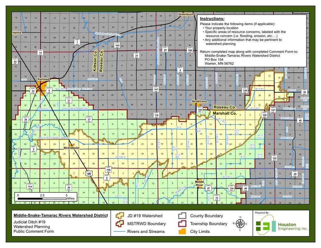
Will be modified map from GIS 6/16 EOD
|
|
|
- Solomon Charles
- 6 years ago
- Views:
Transcription


1 Middle-Snake-Tamarac Rivers Watershed District Judicial Ditch #19 Watershed Regional Conservation Partnership Program (RCPP) Public Scoping Meeting September 26, 2016 Will be modified map from GIS 6/16 EOD
2 Judicial Ditch #19 Watershed Public Scoping Meeting OBJECTIVES 1. Review Tamarac Project Work Team Progress 2. Overview - PL566 Planning process 3. Solicit Comments on the Resource Concerns 4. Inform Public of Future Steps

3 Judicial Ditch #19 Watershed Public Scoping Meeting AGENDA 1. Review Tamarac Project Work Team Progress 2. Introduce Study Area 3. Public Law 566 Planning Process Overview 4. Watershed Setting and Resource Concerns 5. Overview of Next Steps 6. Questions/Public Comment Period
4 Review Tamarac Project Work Team Progress


5 Tamarac River Watershed Area Middle-Snake-Tamarac Rivers Watershed District - 1,476 sq. mi. Tamarac River Watershed sq. mi.

6 1965 PL-566 Work Plan

7 Tamarac PL566 Impoundments Florian & East Park

8 Existing Plan View East Park WMA
9 Florian & East Park Selected Info (1965 Workplan) Florian East Park Drainage Area (sq mi) Storage Capacity (ac-ft) (ac-ft) inches (ac-ft) inches Sediment Recreation Wildlife Flood Water Total Between High & Low Stages Surface Area (acres) (acres) (acres) Sediment Recreation 50 0 Wildlife yr Freq Pool Design Freq Pool Volume of Fill (embankment) (cy) Elevation Top of Dam (ft 1929 MSL) Max Height (ft)
10 Tamarac River PWT Review PWT Focused Mainly on East Park WMA (Nelson Slough) Expansion/Modification/Repair Alternatives Discussed & Analyzed City of Stephen 100 Year Flood Plain Stream Erosion Tamarac River Watershed Area No Purpose and Need Identified
11 Regional Conservation Partnership Program (RCPP) 2014 Farm Bill Red River Retention Authority awarded $12M RRRA approved 20 Watershed Planning Efforts 12 Minnesota, 8 North Dakota MSTRWD entered into Cooperative Agreements with NRCS Judicial Ditch #19 and Judicial Ditch #14


12 Study Area Middle-Snake-Tamarac Rivers Watershed District - 1,476 sq. mi. Tamarac River Watershed sq. mi. Judicial Ditch #19 Watershed 104 sq. mi.
13 Study Area
14 RCPP Planning Process INITIATE PLANNING Discuss purpose and need for project with sponsors/initiate study. Step 1 - IDENTIFY PROBLEMS, OPPORTUNITIES & CONCERNS Identify the need for the proposed action (quantify, extent, magnitude, timing, frequency etc.) Step 2 - DETERMINE OBJECTIVES Write purpose and need statement and Write scope of plan-ea/eis Step 3 - INVENTORY RESOURCES Conduct detailed resource inventories and watershed assessment Economics, social effects, Archeological and historic resources Engineering/Geology/Support maps Document problems Step 4 - ANALYZE RESOURCE DATA Geology, Hydrology & Hydraulics, Cultural, Economics and Social Step 5 - FORMULATE ALTERNATIVES Develop reasonable alternatives, mitigation strategies and costs (Preliminary plans) Step 6 - EVALUATE ALTERNATIVES Env. Resources, Geotechnical, Hydrology & Hydraulics, Economics, Significance of effects, Step 7 - MAKE DECISIONS (EA/EIS, Public Involvement, )
15 RCPP Planning Process - NEPA RCPP planning process will follow National Environmental Policy Act (NEPA) guidelines 40 CFR Public Involvement Primary Goal Ensure all interested and affected parties are aware of the proposed action (a) make diligent efforts to involve the public in preparing and implementing their NEPA procedures.


16 Why RCPP? COST SHARE BREAKDOWN 30% LOCAL 70% NRCS
17 Watershed Setting and Known Resource Concerns


18 Problems Flooding/Flood Damages Como Twp. Agriculture Field Flooding
19 Natural Resource and Water Quality Concerns Channel instability Lack of riparian buffers Degradation and loss of existing grassland and wetland habitats (ex. CRP conversion) Soil erosion (wind and water) from upland sources Degraded soil health
")


20 Problems East Park WMA (Nelson Slough) Capacity/Operation/Outlet Sandbagging Overflows in 1997 JD #19 Channel Instability Water Quality/Erosion/Sediment


21 Natural Resource Goals Middle-Snake-Tamarac Rivers Watershed 10-yr Plan (2011) Restore and protect unique ecological values and recreational opportunities within the district Maintain/improve water quality of rivers, streams, lakes, and groundwater resources. Protect wetlands and channels from sedimentation, and maintain the soil productivity of ag lands with the district Promote district goals to residents within the district as well as local, state, and federal agencies. JD #19 Study Area Public Land Resources JD #19 Study Area Water Resources JD #19 Study Area National Wetland Inventory

22 Overview of Next Steps
23 Watershed Planning Timeline 1-3 Months 3-6 Months 6-12 Months 12+ Months Plan of Work Develop Team Feasibility Report Define Concerns Public Meeting Field Survey Begin H&H Purpose & Need Scope EA Field Survey Ex. H&H Modeling Field Inventory Begin Economics Finalize Ex. H&H Without Project Conditions Economics: Preliminary Alternative Screening Preliminary Cultural Review Alternative Screening Geotech Impacted Lands Alternatives for Detailed Study H&H Alternatives Detailed Survey, Geotech, Design
24 Questions/Comments/ Form Completion

25 Public Input
26 Public Input
27
28 Questions
JD 14 Project Area Project Team Meeting
 Middle-Snake-Tamarac Rivers Watershed District JD 14 Project Area Project Team Meeting January 31, 2017 RCPP Study Process 1. INITIATE PLANNING 1. Discuss purpose and need for project with sponsors/initiate
Project Information. Pursuant to Section 404 of the Clean Water Act (33 U.S. Code 1344), notice is hereby given that
, notice is hereby given that") US ARMY Corps Of Engineers Little Rock District JOINT PUBLIC NOTICE CORPS OF ENGINEERS STATE OF MISSOURI Application Number: SWL 2013-00260 Date: April 15, 2014 Comments Due: May 6, 2014 TO WHOM IT MAY
US ARMY Corps Of Engineers Little Rock District JOINT PUBLIC NOTICE CORPS OF ENGINEERS STATE OF MISSOURI Application Number: SWL 2013-00260 Date: April 15, 2014 Comments Due: May 6, 2014 TO WHOM IT MAY
UPPER GREEN MEADOW PROJECT TEAM. 1 st Meeting December 11 th, 2013 Wild Rice Watershed District Offices
 UPPER GREEN MEADOW PROJECT TEAM 1 st Meeting December 11 th, 2013 Wild Rice Watershed District Offices AGENDA Introductions Goal Timeline/# of Anticipated Meetings 1 st Meeting Objective MN Mediation Agreement
WATERSHED MANAGEMENT IN MINNESOTA. GOVERNANCE, PLANNING, AND FUNDING June 19, 2018 Cedar Rapids, Iowa
 WATERSHED MANAGEMENT IN MINNESOTA GOVERNANCE, PLANNING, AND FUNDING June 19, 2018 Cedar Rapids, Iowa GOVERNANCE - WD 1955 Watershed Act (MN Statute 103D) Local petition to form VOLUNTARY watershed district
TOTAL: 5,250 acres over next 20 years 3
 Siting of Wetland Mitigation in Northeast Minnesota Issues, Concepts, and Alternatives from the Interagency Northeast Mitigation Siting Team 1 2 Projected Future Impacts TOTAL: 5,250 acres over next 20
COON CREEK WATERSHED DISTRICT PERMIT REVIEW Mississippi Dr Coon Rapids, MN SQ FT Residence on 0.64 Acre Lot
 17-082 Van Sloun Residence, Page 1 of 5 COON CREEK WATERSHED DISTRICT PERMIT REVIEW MEETING DATE: May 8, 2017 AGENDA NUMBER: 17 FILE NUMBER: 17-082 ITEM: Van Sloun Residence RECOMMENDATION: Approve with
GREEN MEADOW SUBWATERSHED. PL-566 SMALL Watershed Planning
 GREEN MEADOW SUBWATERSHED PL-566 SMALL Watershed Planning Meeting Objectives: Inform Interdisciplinary Project Team Present Model Results Present Without Project Condition Public Meeting / Scoping Outcome
Use of PL Watershed Authority and Watershed Planning Requirements in the Regional Conservation Partnership Program (RCPP) April 2016
 April 2016") Use of PL 83-566 Watershed Authority and Watershed Planning Requirements in the Regional Conservation Partnership Program (RCPP) April 2016 Provide information on the PL 83-566 watershed authorities within
Use of PL 83-566 Watershed Authority and Watershed Planning Requirements in the Regional Conservation Partnership Program (RCPP) April 2016 Provide information on the PL 83-566 watershed authorities within
The Future of the Watershed Approach Rapid Watershed Assessments. Jan Surface 3 rd National Conference on Ecosystem Restoration July 23, 2009
 The Future of the Watershed Approach Rapid Watershed Assessments Jan Surface 3 rd National Conference on Ecosystem Restoration July 23, 2009 NRCS Strategic Plan Overarching Strategies Cooperative Conservation
Grand Marais Creek Outlet Restoration Appendix
 Grand Marais Creek Outlet Restoration Appendix TABLE OF CONTENTS RLWD Project 60F Grand Marais Creek Outlet Restoration Final Engineer s Plan Report to the Board of Managers of the Red Lake Watershed District
Jurisdiction, Wetland Delineations and Datasheets
 Jurisdiction, Wetland Delineations and Datasheets Presented by Regulatory Project Managers from the USACE Detroit District Regulatory Office and MDEQ Water Resources Division October 26, 2016 US Army Corps
Minnesota EAW Supplement
 Appendix I: Minnesota EAW Supplement Lower Pool 2 Channel Management Study: Boulanger Bend to Lock and Dam No. 2 Minnesota EAW Item Identification A supplement prepared for the Minnesota DNR to identify
Stream and Watershed Restoration Design and Quantitative Benefits. Kelly Gutshall, RLA and Mike LaSala
 Stream and Watershed Restoration Design and Quantitative Benefits Kelly Gutshall, RLA and Mike LaSala Suquehanna Greenway River Towns Workshop September 30, 2013 Benefit Stacking Single Function Multiple
Margaret Walls. RFF First Wednesday Seminar. Green Infrastructure: Using Natural Landscapes for Flood Mitigation and Water Quality Improvements
 THE ROLE OF LAND USE IN ADAPTATION TO INCREASED PRECIPITATION AND FLOODING Margaret Walls RFF First Wednesday Seminar Green Infrastructure: Using Natural Landscapes for Flood Mitigation and Water Quality
Public Notice ISSUED: 11 February 2019 EXPIRES: 13 March 2019
 SPONSOR: Minnesota Board of Water and Soil Resources Public Notice ISSUED: 11 February 2019 EXPIRES: 13 March 2019 REFER TO: MVP-2019-0122-JTB SECTION: 404 - Clean Water Act 1. WETLAND COMPENSATORY MITIGATION
4. Present Activities and Roles
 4. Present Activities and Roles The present missions, authorities, activities and roles of the various agencies involved with flood protection, floodplain management and flood-damage reduction are identified
COON CREEK WATERSHED DISTRICT PERMIT REVIEW
 16-054 Woodland Creek Wetland Banking Restoration Project, Page 1 of 6 COON CREEK WATERSHED DISTRICT PERMIT REVIEW MEETING DATE: August 22, 2016 AGENDA NUMBER: 11 FILE NUMBER: 16-054 ITEM: Woodland Creek
The Beckett s Run Experience. Fort Wayne, Indiana
 The Beckett s Run Experience Fort Wayne, Indiana Introductions Charlie Cochran City of Fort Wayne, Wet Weather Storm & Sewer Engineering Jason Durr, PE Christopher B. Burke Engineering, LLC 2 A Little
Public Notice ISSUED: 13 May 2014 EXPIRES: 12 June 2014
 APPLICANT: Hawkes Company, Inc REFER TO: 1999-04864-CLJ Public Notice ISSUED: 13 May 2014 EXPIRES: 12 June 2014 SECTION: 404 - Clean Water Act 1. APPLICATION FOR PERMIT TO retain dredged and fill material
Watershed Response to Water Storage. 8/1/2012 Paul Wymar Scientist Chippewa River Watershed Project
 Watershed Response to Water Storage 8/1/2012 Paul Wymar Scientist Chippewa River Watershed Project Chippewa River Watershed 1.3 Million Acres Largest tributary watershed in the Minnesota River Basin 7
7.9 Lake Whitney Reallocation
 7.9 Lake Whitney Reallocation 7.9.1 Description of Option Lake Whitney is a major impoundment located on the Brazos River approximately 30 miles north of the City of Waco in Hill and Bosque Counties. The
INFLOW DESIGN FLOOD CONTROL SYSTEM PLAN 40 C.F.R. PART PLANT YATES ASH POND B (AP-B ) GEORGIA POWER COMPANY
 GEORGIA POWER COMPANY") INFLOW DESIGN FLOOD CONTROL SYSTEM PLAN 40 C.F.R. PART 257.82 PLANT YATES ASH POND B (AP-B ) GEORGIA POWER COMPANY EPA s Disposal of Coal Combustion Residuals from Electric Utilities Final Rule (40 C.F.R.
INFLOW DESIGN FLOOD CONTROL SYSTEM PLAN 40 C.F.R. PART 257.82 PLANT YATES ASH POND B (AP-B ) GEORGIA POWER COMPANY EPA s Disposal of Coal Combustion Residuals from Electric Utilities Final Rule (40 C.F.R.
The Clean Water Act. Clarifies protection under the Clean Water Act for streams and wetlands
 Waters of the U.S. Proposed Rule Clarifies protection under the Clean Water Act for streams and wetlands The Clean Water Act The Clean Water Act covers navigable waters, which the Act defines as waters
Prairie Pothole Wetlands: Characteristics, Functions, and Values
 Prairie Pothole Wetlands: Characteristics, Functions, and Values Brian Tangen USGS, Northern Prairie Wildlife Research Center U.S. Department of the Interior U.S. Geological Survey Society for Range Management
Forecast Informed Reservoir Operations for Groundwater Recharge Prado Dam
 Forecast Informed Reservoir Operations for Groundwater Recharge Prado Dam Greg Woodside Orange County Water District Bridging the Gap Conference January 29, 2019 Anaheim Army Corps of Engineers & OCWD
IDEM Wetlands and Streams Regulatory Overview. An overview of IDEM permitting for work in Waters of the State
 IDEM Wetlands and Streams Regulatory Overview An overview of IDEM permitting for work in Waters of the State Who Has Jurisdiction? Adjacent wetland: USACE & IDEM Stream > 1 sq. mile drainage: IDNR, USACE
Mud Lake Lakeshed Assessment
 Mud Lake Lakeshed Assessment The lakeshed vitals table identifies where to focus organizational and management efforts for each lake. Criteria were developed using limnological concepts to determine the
Supplemental Watershed Plan Agreement No. 10 for Neshaminy Creek Watershed Core Creek Dam (PA-620) Bucks County, Pennsylvania
 Bucks County, Pennsylvania") Supplemental Watershed Plan Agreement No. 10 for Neshaminy Creek Watershed Core Creek Dam (PA-620) Bucks County, Pennsylvania Project Authorization USDA's Small Watershed Program is carried out under the
Supplemental Watershed Plan Agreement No. 10 for Neshaminy Creek Watershed Core Creek Dam (PA-620) Bucks County, Pennsylvania Project Authorization USDA's Small Watershed Program is carried out under the
BWSR PROGRAMS THAT ADDRESS NUTRIENT LOSS
 BWSR PROGRAMS THAT ADDRESS NUTRIENT LOSS DRAINAGE LAW BUFFER PROGRAM CREP - GRANT PROGRAMS - PROJECTS 2017 MVTL Agronomy Update Meeting New Ulm, MN February 28, 2017 Jill Sackett Eberhart ~ BWSR Board
Rice SWCD 2018 Annual Plan of Work
 Rice SWCD 2018 Annual Plan of Work Introduction The Rice Soil and Water Conservation District s Annual Plan is developed to provide guidance and direction to district staff and supervisors for the goals
INFLOW DESIGN FLOOD CONTROL SYSTEM PLAN 40 C.F.R. PART PLANT YATES ASH POND 3 (AP-3) GEORGIA POWER COMPANY
 GEORGIA POWER COMPANY") INFLOW DESIGN FLOOD CONTROL SYSTEM PLAN 40 C.F.R. PART 257.82 PLANT YATES ASH POND 3 (AP-3) GEORGIA POWER COMPANY EPA s Disposal of Coal Combustion Residuals from Electric Utilities Final Rule (40 C.F.R.
INFLOW DESIGN FLOOD CONTROL SYSTEM PLAN 40 C.F.R. PART 257.82 PLANT YATES ASH POND 3 (AP-3) GEORGIA POWER COMPANY EPA s Disposal of Coal Combustion Residuals from Electric Utilities Final Rule (40 C.F.R.
Environmental Information Worksheet
 Environmental Information Worksheet Water System Owner (Attach additional sheets if necessary) Needs and Alternatives Provide a brief narrative that describes: Current drinking water system needs. Project
Environmental Resource Inventories. What are ERIs? Significance of information How to use them
 Environmental Resource Inventories What are ERIs? Significance of information How to use them Environmental Resource Inventory - ERI Compiled by the environmental commission Information about the natural
SECTION 7.0 PROJECT FEASIBILITY, ENGINEER S RECOMMENDATION AND DESIGN ISSUES NEEDING RESOLUTION
 SECTION 7.0 PROJECT FEASIBILITY, ENGINEER S RECOMMENDATION AND DESIGN ISSUES NEEDING RESOLUTION 7.1 PROJECT FEASIBILITY The determination of project feasibility is based upon several criteria established
Hydrology and Flooding
 Hydrology and Flooding Background The 1996 flood Between February 4, 1996 and February 9, 1996 the Nehalem reporting station received 28.9 inches of rain. Approximately 14 inches fell in one 48 hour period.
Conservation Reserve Enhancement Program
 CREP Overview Offshoot of the country's largest private-lands environmental improvement program - the Conservation Reserve Program (CRP). Voluntary land retirement program Helps agricultural producers
BUDGET AND RESOURCES
 BUDGET AND RESOURCES Introduction NRDs administer multiple programs that focus on the management of water quantity and the improvement of water quality. While NRDs have taxing authorities they use to support
Community. Restoration. Prevention.
 Community. Restoration. Prevention. Truckee Wetlands Restoration Project Thank you to our Funders Donors to the OUR VALUES PARTNERSHIPS ECOLOGICALLY SOUND ECONOMICS Truckee River Watershed Council May
Walnut Creek Watershed Management Authority. Project Kick Off March 18, 2015
 Walnut Creek Watershed Management Authority Project Kick Off March 18, 2015 Agenda Schedule & Meeting Purpose Meeting Purpose TMDL Raccoon River TMDL Impaired by Nitrate and E.coli Includes Walnut Creek
IMPROVING OUTCOMES FOR STREAM ALTERATION PROJECTS
 IMPROVING OUTCOMES FOR STREAM ALTERATION PROJECTS Bethany Matousek Inland Lakes and Streams Program Coordinator Wetlands, Lakes and Streams Unit DEQ Water Resources Division MatousekB@Michigan.gov 517-243-6421
Shell Rock River Watershed: Water Plans
 Shell Rock River Watershed: Water Plans The Shell Rock River Watershed encompasses Freeborn County. Each county has developed a 10-year rotating comprehensive local water management plan (LWMP) in order
Public Notice PUBLIC NOTICE 30 DAY PUBLIC NOTICE
 PUBLIC NOTICE Date: January 30, 2015 Comment Period Ends: February 28, 2015 Reply by Mail to: Kirk Bargerhuff; or by email to: Kirk.E.Bargerhuff@usace.army.mil Engineering/Planning 696 Virginia Road Concord,
C Fish Lake C Rice Lake C Mud Lake C Weaver Lake C Elm Creek*
 IV. PROBLEMS AND CORRECTIVE ACTIONS Outlined below is an assessment of existing and potential water resource-related issues that are known at this time. These issues have been identified based on Commission
Hydrologic Regime; Past and Present and Water Quality Implications
 Hydrologic Regime; Past and Present and Water Quality Implications Waseca County Water Plan Meeting Waseca County Courthouse Annex November 16, 2016 Dan Girolamo, Area Hydrologist, Waterville, MN Topics
Steve Glasgow- NRCS Shanon Phillips- OCC OCLWA 24 th Annual Symposium April 8-9, 2015, Stillwater, OK
 Steve Glasgow- NRCS Shanon Phillips- OCC OCLWA 24 th Annual Symposium April 8-9, 2015, Stillwater, OK Conservation Partnership Roles NRCS- conservation practice design, ID conservation resource needs,
16 September Water Management Wilmington District. US Army Corps of Engineers BUILDING STRONG
 FALLS LAKE OPERATIONS UNRBA Board Meeting 16 September 2015 Water Management Wilmington District US Army Corps of Engineers Wilmington District 2 Water Management Mission 24/365 Operate Wilmington District
CONSERVATION RESERVE ENHANCEMENT PROGRAM (CREP) SUMMARY OF THE WISCONSIN S PROJECT
 SUMMARY OF THE WISCONSIN S PROJECT") CONSERVATION RESERVE ENHANCEMENT PROGRAM (CREP) SUMMARY OF THE WISCONSIN S PROJECT Wisconsin Department of Agriculture, Trade and Consumer Protection USDA Farm Service Agency JANUARY 2003 Governor McCallum
CONSERVATION RESERVE ENHANCEMENT PROGRAM (CREP) SUMMARY OF THE WISCONSIN S PROJECT Wisconsin Department of Agriculture, Trade and Consumer Protection USDA Farm Service Agency JANUARY 2003 Governor McCallum
Model Riparian Buffer Ordinance.
 Model Riparian Buffer Ordinance. This is a sample riparian buffer ordinance written as an amendment to an existing zoning ordinance. This ordinance complies with the state minimum standards for river corridor
Little River Watershed Restoration Project. Mark Powell, Consultant Natural Resources Management
 Little River Watershed Restoration Project Mark Powell, Consultant Natural Resources Management Lessons Learned Strong partnerships RC&D, Soil and Water, 2 counties, Albemarle Commission, Universities,
Distributed Storage Alternative Screening Analysis February 17, 2015
 Distributed Storage Alternative Screening Analysis February 17, 2015 Executive Summary The Distributed Storage Alternative (DSA) was conceptualized during the public comment and alternative screening process
2 USCID/EWRI Conference
 1 X 2 USCID/EWRI Conference x Water Quality of Surface Irrigation Returns in Southern Idaho Clarence W. Robison 1 Richard G. Allen 2 Richard Merkle 3 ABSTRACT The Clean Water Act and Safe Drinking Water
a vision for a more resilient Iowa Larry J Weber Director, IIHR Hydroscience & Engineering
 Larry J Weber (larry-weber@uiowa.edu) Director, IIHR Hydroscience & Engineering 1 IIHR is a unit of the University of Iowa s College of Engineering. At IIHR, students, faculty members, and research engineers
ND Detention Project Development Update
 ND Detention Project Development Update Upper Red River Basin Halstad, MN = 8 Upstream Subwatersheds Fargo, ND = 3 Upstream Subwatersheds Halstad, MN Fargo, ND Wild Rice Otter Tail Bois de Sioux Upstream
EXECUTIVE SUMMARY DES PLAINES RIVER WATERSHED-BASED PLAN WHY A WATERSHED-BASED PLAN? WHAT IS A WATERSHED?
 Des Plaines River Watershed-Based Plan EXECUTIVE SUMMARY June 2018 EXECUTIVE SUMMARY DES PLAINES RIVER WATERSHED-BASED PLAN WHY A WATERSHED-BASED PLAN? Water is elemental to our lives. Plants and animals,
Protecting and Enhancing Ecosystem Services the Role of Wetlands and Watershed Management in Flood Attenuation Dr. Mark Gloutney Director Regional
 Protecting and Enhancing Ecosystem Services the Role of Wetlands and Watershed Management in Flood Attenuation Dr. Mark Gloutney Director Regional Operations Eastern Canada April 14 2016 Changes in Storm
FY Biennial Budget Request Mille Lacs SWCD
 FY 18-19 Biennial Budget Request Mille Lacs SWCD Total Requested Biennial State Contribution: $1,075,818.00 BBR ID BBR16-0773 Total Leveraged Funds $200,000.00 Submitted Date 4/14/2016 Total Resource Project
Headwater Wetland Restoration Techniques The Wetland Drain Restoration Project
 Headwater Wetland Restoration Techniques The Wetland Drain Restoration Project Tools for Managing Small Drainage Features in Rural Landscapes Workshop, March 5, 2014 Dave Richards, Partnership Specialist,
7.6 Lake Aquilla Storage Reallocation
 Management of Existing Supplies Lake Aquilla Storage Reallocation 7.6 Lake Aquilla Storage Reallocation 7.6.1 Description of Option Figure 7.6-1 is an aerial map of Lake Aquilla showing the water surface
Notice No Closing Date: May 12, 2017
 Public Notice U.S. Army Corps of Engineers Pittsburgh District In Reply Refer to Notice No. below US Army Corps of Engineers, Pittsburgh District 1000 Liberty Avenue Pittsburgh, PA 15222-4186 Application
Ponds. Pond A water impoundment made by excavating a pit, or constructing a dam or an embankment.
 POND SITE SELECTION AND CONSTRUCTION Uses, Planning, & Design David Krietemeyer Area Engineer USDA-NRCS June 20, 2008 Uses Considerations for Location of Commonly Used Terms Pond A water impoundment made
How is Water Quality Affected by Land Use?
 Watershed Connections Lesson Les4 3 How is Water Quality Affected by Land Use? Overview What are the benefits of a healthy watershed? What are examples of land uses? What types of pollution can come from
COON CREEK WATERSHED DISTRICT PERMIT REVIEW. Spring Lake Park Schools Westwood Middle School st Avenue NE, Spring Lake Park, MN 55432
 PAN 16-112, Westwood Middle School, Page 1 of 6 COON CREEK WATERSHED DISTRICT PERMIT REVIEW MEETING DATE: August 22, 2016 AGENDA NUMBER: 10 FILE NUMBER: 16-112 ITEM: Westwood Middle School RECOMMENDATION:
Natural Channel Design and Dead River Case Study Stream Restoration in the Great Lakes Basin: Using In-stream Structures & Natural Channel Design
 Natural Channel Design and Dead River Case Study Stream Restoration in the Great Lakes Basin: Using In-stream Structures & Natural Channel Design January 22, 2013 S. Paige Baker, PE, MLE Presentation Outline
AGRICULTURAL DRAINAGE
 AGRICULTURAL DRAINAGE ARCHITECTURE + ENGINEERING + True Expertise + Sustainable Solutions ENVIRONMENTAL + PLANNING Facing the Challenges Together With over 40 years of experience, ISG is focused on improving
Isanti Soil and Water Conservation District Strategic Framing
 Isanti Soil and Water Conservation District Strategic Framing Completed August 18, 2015 Adopted by the Isanti SWCD Board September 15, 2015 Assisted by Jason Weinerman MN Board of Water and Soil Resources
Proposal for Plumas Watershed Forum. 1. Project Name: Feather River Irrigated Lands Water Quality Improvement Program.
 Proposal for Plumas Watershed Forum 1. Project Name: Feather River Irrigated Lands Water Quality Improvement Program. 2. County: The project area encompasses Plumas County and parts of Sierra and Lassen
MIDDLE MISSISSIPPI RIVER (MMR) REGIONAL CORRIDOR
 REGIONAL CORRIDOR") MIDDLE MISSISSIPPI RIVER (MMR) REGIONAL CORRIDOR Illinois Missouri General Expense Project Proposal For Comprehensive Analyses of Multi-jurisdictional Use and Management of Water Resources on a Watershed
MIDDLE MISSISSIPPI RIVER (MMR) REGIONAL CORRIDOR Illinois Missouri General Expense Project Proposal For Comprehensive Analyses of Multi-jurisdictional Use and Management of Water Resources on a Watershed
A Brief Overview of U.S. Agricultural Conservation Policy
 A Brief Overview of U.S. Agricultural Conservation Policy Roger Claassen Economic Research Service US Department of Agriculture The views expressed are those of the author and cannot necessarily be attributed
Regional Stormwater Management Plan for Troy Brook, Morris County, New Jersey
 Regional Stormwater Management Plan for Troy Brook, Morris County, New Jersey Executive Summary Troy Brook is in the Whippany River watershed, which has the first TMDL in the State of New Jersey, for fecal
Nutrient Management in. A presentation to the West Metro Water Alliance
 Nutrient Management in Developing and Agricultural Areas A presentation to the West Metro Water Alliance Chris Meehan, P.E. May 25, 2011 Agenda Physical Improvements Planning Improvements How to get it
Arizona Department of Forestry and Fire Management
 Arizona Department of Forestry and Fire Management The Power of Partnership Agreements Jeff Whitney, Arizona State Forester Arizona Overview Arizona s a land of many ecosystems Land Ownership: 42% federal,
Informational Meeting- July 21, Boxelder B-2/B-3 Watershed Planning Study
 Informational Meeting- July 21, 2015 Boxelder B-2/B-3 Watershed Planning Study Agenda Introductions Background & History Purpose & Need NRCS Watershed Planning Program Work Completed to Date Longer term
Environmental. US Army Corps of Engineers BUILDING STRONG
 Environmental US Army Corps of Engineers Who we are Environmental Analysis Branch Environmental Specialists in the Areas of: Archeology Biology Chemistry Ecology & Restoration Environmental Engineering
INFLOW DESIGN FLOOD CONTROL SYSTEM PLAN PLANT GASTON GYPSUM POND ALABAMA POWER COMPANY
 INFLOW DESIGN FLOOD CONTROL SYSTEM PLAN PLANT GASTON GYPSUM POND ALABAMA POWER COMPANY Section 257.82 of EPA s regulations requires the owner or operator of an existing or new CCR surface impoundment or
Fountain Lake Restoration Project
 NRT, AN OBG COMPANY, PRESENTS: Fountain Lake Restoration Project Rich Weber, NRT WEDA Midwest Conference, March 8-10, 2017 AGENDA Project History Lake Modeling Dredging Plan Upland Sediment Placement Site
Boardman River Dams Committee (BRDC) Detailed Analysis of Alternatives
 Detailed Analysis of Alternatives") Boardman River Dams Committee (BRDC) Detailed Analysis of Alternatives Presentation Outline Summary of Detailed Analysis Summary of Cost and Economic Impacts Public Opinion Survey Questions and Discussion
Boardman River Dams Committee (BRDC) Detailed Analysis of Alternatives Presentation Outline Summary of Detailed Analysis Summary of Cost and Economic Impacts Public Opinion Survey Questions and Discussion
Riparian Setback- What is that and what should I be doing? October 25th, 2016 Presented by: Anil Tangirala, PE, CFM, ENV SP
 Riparian Setback- What is that and what should I be doing? October 25th, 2016 Presented by: Anil Tangirala, PE, CFM, ENV SP Agenda Introduction Stream and Riparian Impacts Ohio EPA Stormwater General Permit
WHY ARE STREAM IMPROVEMENTS NEEDED IN TENNESSEE? TENNESSEE STREAMS
 WHY ARE STREAM IMPROVEMENTS NEEDED IN TENNESSEE? TENNESSEE STREAMS Most diverse aquatic fauna in the country Majority of West TN streams are channelized 36,000 miles of degraded stream are in need of restoration
AGRICULTURAL DRAINAGE
 AGRICULTURAL DRAINAGE ARCHITECTURE + ENGINEERING + ENVIRONMENTAL + PLANNING True Expertise + Sustainable Solutions Facing the Challenges Together With over 40 years of experience, ISG is focused on improving
Chapter 105 Dam Safety and Waterway Management
 Chapter 105 Dam Safety and Waterway Management An overview PA Department of Environmental Protection Bureau of Watershed Management Division of Waterways, Wetlands, & Stormwater Management Purpose The
Developing Interim Milestones & Criteria to Measure Progress. Thomas E. Davenport
 Developing Interim Milestones & Criteria to Measure Progress Thomas E. Davenport davenport.thomas@epa.gov We Cannot Solve The Problems That We Have Created With The Same Thinking That Created Them --Albert
Project Information. Pursuant to Section 404 of the Clean Water Act (33 U.S. Code 1344), notice is hereby given that
, notice is hereby given that") JOINT PUBLIC NOTICE CORPS OF ENGINEERS STATE OF ARKANSAS Application Number: SWL 2012-00397 Date: 21 November 2012 Comments Due: 21 December 2012 TO WHOM IT MAY CONCERN: Comments are invited on the work
JOINT PUBLIC NOTICE CORPS OF ENGINEERS STATE OF ARKANSAS Application Number: SWL 2012-00397 Date: 21 November 2012 Comments Due: 21 December 2012 TO WHOM IT MAY CONCERN: Comments are invited on the work
South Washington Watershed District. Stormwater Pollution Prevention Plan (SWPPP)
") South Washington Watershed District Stormwater Pollution Prevention Plan (SWPPP) June 2008 1 I. Public Education and Outreach... 4 a) Distribute Educational Materials... 4 b) Education Implementation...
South Washington Watershed District Stormwater Pollution Prevention Plan (SWPPP) June 2008 1 I. Public Education and Outreach... 4 a) Distribute Educational Materials... 4 b) Education Implementation...
Project Information. Pursuant to Section 404 of the Clean Water Act (33 U.S. Code 1344), notice is hereby given that
, notice is hereby given that") US ARMY Corps Of Engineers Little Rock District JOINT PUBLIC NOTICE CORPS OF ENGINEERS STATE OF ARKANSAS Application Number: 2013-00331 Date: November 4, 2013 Comments Due: December 4, 2013 TO WHOM IT
US ARMY Corps Of Engineers Little Rock District JOINT PUBLIC NOTICE CORPS OF ENGINEERS STATE OF ARKANSAS Application Number: 2013-00331 Date: November 4, 2013 Comments Due: December 4, 2013 TO WHOM IT
Chapter 3 FEDERAL POLICIES SOUTH DAKOTA DRAINAGE MANUAL
 Chapter 3 FEDERAL POLICIES SOUTH DAKOTA DRAINAGE MANUAL October 2011 Table of Contents Section Page 3.1 ENVIRONMENTAL...3-1 3.2 HEALTH...3-3 3.3 HISTORIC AND ARCHEOLOGICAL PRESERVATION...3-4 3.4 LAND
City of Fairmont Storm Water Pollution Prevention Plan Annual Public Meeting. June 11, 2018
 City of Fairmont Storm Water Pollution Prevention Plan Annual Public Meeting June 11, 2018 Why is Water Quality Important? Water has always been important to Minnesota and is a key part of our history,
Integrating Sea Level Rise Considerations in the South Bay Salt Ponds Restoration Project. Norma J. Camacho Chief Operating Officer, Watersheds
 Integrating Sea Level Rise Considerations in the South Bay Salt Ponds Restoration Project Norma J. Camacho Chief Operating Officer, Watersheds Presentation Overview Mission of the District Santa Clara
Phase II: Proposed (regulated) Impervious in disturbed area (ac) Long Lake Existing Impervious in disturbed area (ac)
 Impervious in disturbed area (ac) Long Lake Existing Impervious in disturbed area (ac)") Permit Application No.: 17-181 Rules: Erosion Control, Wetland Protection, and Waterbody Crossings & Structures Applicant: Hennepin County Received: 4/27/17 Project: CSAH 112 Phase II Complete: 9/5/17
Permit Application No.: 17-181 Rules: Erosion Control, Wetland Protection, and Waterbody Crossings & Structures Applicant: Hennepin County Received: 4/27/17 Project: CSAH 112 Phase II Complete: 9/5/17
INDIAN CREEK WATERSHED PLAN EXECUTIVE SUMMARY
 INDIAN CREEK WATERSHED PLAN EXECUTIVE SUMMARY The Indian Creek Watershed covers a 38 square mile area in southern Lake County, Illinois that drains 24,116 acres before discharging into the Des Plaines
Instream Flow Study for the Proposed Lower Bois d Arc Creek Reservoir, Texas
 450,000 400,000 350,000 300,000 250,000 200,000 150,000 Instream Flow Study for the Proposed Lower Bois d Arc Creek Reservoir, Texas 100,000 50,000 0 Jan-48 Jan-51 Jan-54 Jan-57 Jan-60 Jan-63 Jan-66 Jan-69
Lake Creek Watershed Management Plan Public Meeting. Arrowhead Lake May 3, :00 PM
 Lake Creek Watershed Management Plan Public Meeting Arrowhead Lake May 3, 2018 6:00 PM Agenda I. Welcome and Introductions II. III. IV. Watershed Basics Overview of Lake Creek Watershed Elements of a Successful
DALLAS FLOODWAY PROJECT
 DALLAS FLOODWAY PROJECT DRAFT FEASIBILITY REPORT and DRAFT ENVIRONMENTAL IMPACT STATEMENT PUBLIC MEETING Rob Newman Director, Trinity River Corridor Project, Fort Worth District 8 May 2014 US Army Corps
PWD s Systematic Watershed-wide Approach to Stormwater Mgmt.
 PWD s Systematic Watershed-wide Approach to Stormwater Mgmt. Jeffrey Featherstone, PhD Director, Center for Sustainable Communities, Temple University Paul DeBarry, PE, PH, GISP, D.WRE Director, Geospatial
Agricultural Ditches, Waterways and Wetlands: Sorting It Out
 Agricultural Ditches, Waterways and Wetlands: Sorting It Out Eric Metz Planning & Policy Manager Aquatic Resource Management 503-986-5266 eric.metz@state.or.us Clatsop SWCD Waterways Seminar March 16,
Conservation District Business Plan Steuben County Soil and Water Conservation District
 Conservation District Business Plan Steuben County Soil and Water Conservation District I find the great thing in this world is not so much where we stand as in what direction we are moving Oliver Wendell
Upper Mississippi River Floodplain Island Restoration Details
 Upper Mississippi River Floodplain Island Restoration Details Mississippi Makeover Meeting Citizens Advisory Group December 1, 2009 Hastings City Hall Community Room Scot Johnson Minnesota Department of
Report. Environmental Water Demands. Butte County Department of Water and Resource Conservation Integrated Water Resources Plan.
 Report Butte County Department of Water and Resource Conservation Integrated Water Resources Plan s June 2004 s Section 1 - Introduction 1.1 Project Description This project is a preliminary investigation
COON CREEK WATERSHED DISTRICT PERMIT REVIEW th Ave NE Ham Lake, MN 55304
 18-151 Meyer Garage, Page 1 of 5 COON CREEK WATERSHED DISTRICT PERMIT REVIEW MEETING DATE: January 28, 2019 AGENDA NUMBER: 9 FILE NUMBER: 18-151 ITEM: Meyer Garage RECOMMENDATION: Approve with 2 Stipulations
Squaw Creek Watershed Management Plan 12/16/2014
 Appendix 2: Listening Input Listening sessions were held throughout the watershed to notify residents about the planning process, to introduce the topic of watershed management, and to solicit input. s
DEPARTMENT OF THE ARMY LITTLE ROCK DISTRICT, CORPS OF ENGINEERS POST OFFICE BOX 867 LITTLE ROCK, ARKANSAS
 REPLY TO ATTENTION OF DEPARTMENT OF THE ARMY LITTLE ROCK DISTRICT, CORPS OF ENGINEERS POST OFFICE BOX 867 LITTLE ROCK, ARKANSAS 72203-0867 www.swl.usace.army.mil/ CESWL-RD March 20, 2012 APPLICATION NO.