AGENCY. Letters AGENCY. Letters
|
|
|
- Samuel Davidson
- 5 years ago
- Views:
Transcription


1

2
3 AGENCY Letters AGENCY Letters Section 601 of the Water Resources Development Act (WRDA) of 2000 approved the Final Integrated Feasibility Report and Programmatic Environmental Impact Statement (the Plan), which is the framework for modifications and operational changes to the Central and Southern Florida (C&SF) Project needed to restore, preserve and protect the south Florida ecosystem while providing for other water-related needs of the region, including water supply and flood protection. This legislation is now commonly referred to as the Comprehensive Everglades Restoration Plan (CERP). Section 601 (l) of WRDA 2000 requires that the Secretaries of the Army and the Interior jointly submit a Report to Congress not less than every five years on the implementation of the Plan. In accordance with Section 601 (l) 1 of the Act this report includes: the determination of each Secretary, and the Administrator of the Environmental Protection Agency, concerning the benefits to the natural system and the human environment achieved as of the date of the report and whether the completed projects of the Plan are being operated in a manner that is consistent with the requirements of subsection (h)... Following are these determinations and a letter of support signed by the Florida Department of Environmental Protection and the South Florida Water Management District (SFWMD). CERP 2010 Report to Congress i
4 THIS PAGE Intentionally Left Blank ii
 of the WRDA 2000 I have determined that satisfactory progress is being made towards achieving the benefits for the natural system and the human environment")
5 DEPARTMENT OF THE ARMY OFFICE OF THE ASSISTANT SECRETARY CIVIL WORKS 108 ARMY PENTAGON WASHINGTON DC JUN Determination of the Secretary of the Army for the Five-Year Report to Congress Pursuant to Section 601(L) of the WRDA 2000 I have determined that satisfactory progress is being made towards achieving the benefits for the natural system and the human environment envisioned in the Comprehensive Everglades Restoration Plan (CERP). The Army Corps of Engineers, in partnership with its primary partner the South Florida Water Management District, continues to develop an integrated strategy for implementation of the Plan. In order for the Plan to be implemented successfully it is imperative to maintain coordination with the Department of Interior, as well as tribal governments and other federal and state partners, all of which have actively participated in the development and progress of this program. In the past five years, three projects were authorized in the Water Resources Development Act of 2007: Indian River Lagoon South, Picayune Strand Restoration and Site 1 Impoundment. The authorization of these projects has allowed the agencies involved in the CERP to begin construction on features that provide needed momentum toward the restoration of the Everglades. In addition, funding provided through the passage of the American Recovery and Reinvestment Act allowed construction on both CERP and other south Florida Restoration projects to proceed at a quicker pace and provide jobs in south Florida. The Water Resources Development Act of 2000 conveyed the expectation that adaptive management principles would be applied during CERP implementation. The CERP Monitoring and Assessment Plan, a scientifically rigorous system-wide/regional monitoring program, has laid the foundation by generating information to support understanding of ecosystem responses to CERP implementation. Extensive new data has been collected over the last five years from applied research, field monitoring and computer analysis that informs the understanding of the complex Everglades environment. The value of new scientific information is its ability to improve decision making within CERP, thereby improving restoration success. The Master Agreement was executed between the U.S. Army Corps of Engineers and the South Florida Water Management District in August It is a landmark document that paved the way forward for Everglades restoration. It describes how the U.S. Army Corps of Engineers and the South Florida Water Management District will share in the costs of constructing and operating the CERP projects. It establishes a new framework for an equal partnership between the Corps and District for joint decision-making in CERP. Five project partnership agreements have been executed on CERP projects since the execution of the Master Agreement. Printed on Recycled Paper
6 The Master Implementation Sequencing Plan has been incorporated into the Integrated Delivery Schedule which encompasses not only CERP projects, but also other major south Florida restoration efforts and their interdependencies. The Integrated Delivery Schedule (IDS) provides the comprehensive schedule of construction for projects in the South Florida ecosystem restoration program. The goal of the IDS is to provide the optimum sequencing of key restoration projects to deliver meaningful restoration benefits as early as possible, consistent with law and available funding. The IDS incorporates both Federal and State initiatives. We appreciate the efforts of the State of Florida in regards to land acquisition, construction and water reservations. The State began implementation on several projects or portions of projects, some of which are identified in CERP, with the goal of advancing the delivery of benefits to the natural and human environments. Construction was completed or initiated on several features while other features plans and specifications were developed. In addition the state has established two Restricted Allocation Area rules and two reservations or allocations of water, for protecting natural systems from consumptive uses. Close coordination between state and federal agencies plays a key role in these projects. The next five years hold the promise of even more tangible, beneficial change in the south Florida ecosystem, with construction expected to be completed on five features and construction anticipated to be underway on several more ecosystem restoration projects. We look forward to continuing our progress with the Department of the Interior, the State of Florida, and our other partners in achieving the benefits for the natural system and the human environment envisioned by CERP. &. ~ o-ellen Darcy Ass' ta t Secretary of the Arm (Civil Works)


7

8

9

10
11

12
13
14 THIS PAGE Intentionally Left Blank
15 EXECUTIVE Summary EXECUTIVE Summary There are no other Everglades in the world. They are, they have always been, one of the unique regions of the Earth, remote, never wholly known. Nothing anywhere else is like them: their vast glittering openness, wider than the enormous visible round of the horizon, the racing free saltness and sweetness of their massive winds, under the dazzling blue heights of space. They are unique also in the simplicity, the diversity, the related harmony of the forms of life they enclose. The miracle of the light pours over the green and brown expanse of saw grass and of water, shining and slow-moving below, the grass and water that is the meaning and the central fact of the Everglades of Florida. It is a river of grass. - Marjory Stoneman Douglas, The Everglades: River of Grass, 1947 The Greater Everglades Ecosystem, as the largest subtropical wilderness in the United States, encompasses some of America s most diverse and distinctive wetland landscapes. These include the sloughs and lakes of the upper Kissimmee River watershed, the meandering Kissimmee River and its broad floodplain, the vast Lake Okeechobee, the sawgrass plain, ridge and slough wetlands and marl prairies south of the Lake, and ultimately the bays and estuaries of the Florida peninsula. Distinctive in their own right, these landscapes are hydrologically and ecologically connected across more than 220 miles from north to south and across 18,000 square miles of southern Florida. These defining characteristics were recognized internationally by the United Nations Educational, Scientific, and Cultural Organization, UNESCO, and the Ramsar Convention on Wetlands of International Importance when they designated Everglades National Park as an International Biosphere Reserve and World Heritage Site on October 26, In 1993, the World Heritage Committee placed the Park on their List of World Heritages in Danger due to the damage suffered from Hurricane Andrew and the continued serious deterioration in water flow and quality as a result of manmade alterations to the natural system and urban and agricultural runoff. Although, the Park was removed from the list in 2007 in expectation that the restoration programs being put in place would protect the resources, continued degradation of the ecosystem combined with slow progress in restoration efforts resulted in the Park being relisted in August, This report provides the status of the restoration efforts under way and the more recent significant advances of those efforts. CERP 2010 Report to Congress iii
16 RESTORING the South Florida Ecosystem Due to the continued decline in overall health of the ecosystem and recognizing that a healthy ecosystem is fundamental to a healthy economy, numerous initiatives and construction projects are now under way to revitalize and protect the expansive south Florida ecosystem. A major component of south Florida ecosystem restoration is implementation of the Comprehensive Everglades Restoration Plan (CERP). Approved by Congress in the Water Resources Development Act (WRDA) of 2000, CERP is a framework for large-scale restoration. CERP is based on getting the water right by improving water quality, quantity, timing and distribution. There are other important projects that pre-date CERP for Everglades restoration that work hand-in-hand to realize the benefits of the CERP. These important companion Foundation Projects restore the Kissimmee River and improve water flows into Everglades National Park. The State of Florida is also working to restore and protect the Northern Everglades by creating water quality treatment marshes for water flowing into Lake Okeechobee, coastal estuaries and the Everglades. Working across political boundaries and in collaboration with partners and many stakeholders at the local, state and federal level, restoration of the historic Everglades ecosystem is one of the largest and most complex environmental restoration efforts in North America. The overarching goal is to capture the fresh water that now flows unused to the ocean and the gulf and redirect it to storage for delivery to natural areas when they need it. Returning a more historic flow of water to the River of Grass will not only revive the native habitat for 68 federally listed threatened and endangered species, it will also naturally replenish the underground aquifers that supply drinking water to the population of south Florida. Major components of CERP include above-ground and underground water storage, water preserve areas, management of Lake Okeechobee as an ecological resource, improved water deliveries to the St. Lucie and Caloosahatchee estuaries, treatment wetlands, improved water deliveries to the Everglades, removal of barriers to the natural sheetflow of water, reuse of wastewater, and improved water conservation. Sound environmental science is at the heart of this effort, much of it new and pioneering work. Since 2000, much has been learned through rigorous Everglades research, extensive monitoring and the development and refinement of computer models. The CERP planners recognized this natural progression in applied science and included a commitment to adaptive management as an integral part of CERP implementation to support improved decision-making and CERP performance over time. As restoration and scientific investigations advance, so, too, do the opportunities to incorporate CERP improvements and changes to better achieve restoration goals and objectives. FIVE YEARS OF RESTORATION and Implementation Progress This second Report to Congress details the progress made over the last five-year reporting period on implementation of the Comprehensive Everglades Restoration Plan approved in Continuous project and program level achievements for both CERP and foundation projects have produced not only much needed momentum, but also greater confidence in restoration efforts. During this period, a number of earlier initiatives and construction projects continued to move forward, and significant progress has been made in many areas, including additional scientific knowledge and understanding of the natural, pre-drainage system and how water flow, depth and timing influences Everglades ecology. iv
 for CERP and other restoration projects.")
17 Highlights for this period include: apassage of WRDA 2007, authorizing construction of three major projects: Site 1 Impoundment, Indian River Lagoon-South and Picayune Strand Restoration. aincreased construction funding and job creation provided by the passage of the American Recovery and Reinvestment Act (ARRA) for CERP and other restoration projects. ainitiation of Federal construction for the first CERP projects. a Realization of first significant restoration benefits as projects, both CERP and non-cerp, move forward. EXECUTIVE Summary CERP Authorized Projects ainitiated construction for the Merritt Pump Station feature of Picayune Strand Restoration, building on the state s work of filling and plugging seven miles of the Prairie Canal; removal of 65 miles of roadways and installation of seventeen culverts. Wading birds, black bears and the endangered Florida panther have already been observed within the 13,000 acres of restored habitat. ainstalled pilot projects for aquifer storage and recovery and ongoing cycle testing and monitoring at two sites: Kissimmee River and Hillsboro Canal. acompleted designs to prepare Indian River Lagoon- Kissimmee Aquifer Storage and South for construction. Recovery Installation aawarded the first construction contract for the Site 1 Impoundment, adjacent to the Arthur R. Marshall Loxahatchee National Wildlife Refuge. aproject Implementation Reports completed or nearly completed for: Caloosahatchee (C-43) West Basin Storage Reservoir, C-111 Spreader Canal Western Project, Broward County Water Preserve Areas and Biscayne Bay Coastal Wetlands (Phase I). Foundation Projects akissimmee River Restoration: More natural flow was reestablished for four miles in 2007 and four more miles in 2009 for a total of 22 miles of the meandering Kissimmee River now restored. Seasonal rains and flows now inundate over 15,000 acres of restored floodplain habitat that has led to a remarkable rebound in the abundance and diversity of wildlife now found in the area. A decade of comprehensive monitoring has now documented that the environmental response to the changes in the river and its floodplain has already surpassed all expectations. amodified Water Deliveries to Everglades National Park: Initiated construction of the one-mile Tamiami Trail Bridge portion of the project to directly benefit water flows to Everglades National Park, completed construction of necessary flood mitigation improvements in the 8.5 Square Mile Area and continued design for remaining features. ac-111 (South Dade): Completed construction of a series of retention/detention zones to reduce seepage from Everglades National Park and maintain healthier water conditions for both flora and fauna within the Park. acompleted construction of two Critical Projects and three more are in construction, all of which are providing a healthier ecosystem through improved water management that helps to restore wetland functionality and associated wildlife and plant life. CERP 2010 Report to Congress v
18 State Expedited Projects acompleted an additional 6,000 acres of Stormwater Treatment Area with another 12,000 acres currently under construction. To date, more than 45,000 acres of effective treatment marsh are in operation and using plants to naturally remove phosphorus from water flowing into the Everglades. In addition to providing cleaner water for the environment, these areas are serving as vast feeding and breeding grounds for numerous avian and aquatic species, such as the Everglade Snail Kite and American alligator. ainitiated construction of the Deering Estates Flowway, part of Phase 1 of the proposed CERP Biscayne Bay Coastal Wetlands Project to restore more natural water flows to the Bay and Biscayne National Park thus helping to restore the estuarine environment and associated plant and animal life. acompleted construction of L-31E Culverts, part of Phase 1 of the proposed CERP Biscayne Bay Coastal Wetlands Project. ainitiated construction of the proposed CERP C-111 Spreader Canal - Western Project to benefit Florida Bay by restoring freshwater wetlands, tidal wetlands and near-shore habitat. atest cells constructed for the CERP Caloosahatchee River (C-43) West Basin Storage Reservoir and the Indian River Lagoon-South C-44 Reservoir/Stormwater Treatment Area projects. Completed designs on both features. acompleted Acme Basin B Discharge Phase I (C-51 pump and C-1 canal improvements) and Phase II (Section 24 Impoundment) components to eliminate direct discharge of storm water into A.R.M. Loxahatchee National Wildlife Refuge, thus improving water quality within the Refuge. ainitiated design work on all proposed CERP Broward County Water Preserve Area components (C-9 Impoundment; C-11 Impoundment; Water Conservation Area-3A/3B Seepage Management). Remaining design and construction will be undertaken by the U.S. Army Corps of Engineers following project authorization. ainitiated construction on Lakeside Ranch Phase 1 (Stormwater Treatment Area [STA] North and S- 650 Pump Station). Phase II design (STA South and S-191A Pump Station) is under way. acompleted L-8 Reservoir components of the proposed Loxahatchee River Watershed Restoration CERP project, including installation of the G-160 and G-161 structures. Design and construction plan for L-8 additional storage capacity is complete. acompleted the acquisition of 26,800 acres of strategically located property, providing construction opportunities for environmental and water quality improvements. Protecting Water for the Environment afulfilling its commitment to meet the requirements of WRDA 2000 to set aside water generated through project construction first for the protection of fish and wildlife ahead of consumptive uses, the South Florida Water Management District (SFWMD) as CERP s local sponsor undertook rulemaking to reserve the water identified for the natural system in three Project Implementation Reports authorized by the Congress. The rulemaking also created a restricted allocation rule for the Everglades Protection Area. - In February 2009 the SFWMD adopted a water reservation for the Picayune Strand and Fakahatchee Estuary, the first-ever water reservation for America s Everglades. - The SFWMD also initiated rulemaking to reserve water for the Caloosahatchee River and Estuary on Florida s west coast as part of the upcoming C-43 West Basin Storage Reservoir project. - In addition, the SFWMD adopted a second reservation for the St. Lucie River and Estuary as part of the Indian River Lagoon-South project. vi

19 Program Coordination aexecution of the Master Agreement between the SFWMD and the Department of the Army, which serves as the umbrella accord between the State and federal partners to govern all CERP projects. aexecution of Project Partnership Agreements for five projects: Picayune Strand Restoration, Site 1 Impoundment, L-31N (L-30) Seepage Management Pilot, Melaleuca Eradication and Other Exotic Plants Implement Biological August 13, 2009 signing of the Master Agreement Controls and Indian River Lagoon - South. aincorporation of the CERP Master Implementation Sequencing Plan into the Integrated Delivery Schedule, which not only includes CERP projects, but also includes other major ongoing restoration efforts and that recognizes project interdependencies and interagency prioritization and budgeting. WATER QUALITY Challenges Water quality improvements are central to hydrologic restoration. In the last decade, the State of Florida has made progress in improving the quality of the water entering the Everglades. The primary focus of the State effort is in reducing phosphorus levels in discharges to the Everglades Protection Area, including the Arthur R. Marshall Loxahatchee National Wildlife Refuge, the other Water Conservation Areas, and Everglades National Park. To date, the State has expended over one billion dollars and the United States has expended 285 million dollars on this effort. Despite the progress made to date, sustained efforts - at additional, very substantial costs - will be required to attain water quality standards in the Everglades. At a minimum, additional stormwater treatment area (STA) acreage is necessary to clean existing water flowing to the Everglades, as well as the additional water needed for restoration, to levels necessary to achieve and maintain water quality standards. Improved nutrient reduction efforts upstream of the STAs, such as Best Management Practices, have the potential to increase STA nutrient-reduction performance and to decrease the additional acreage of STAs required to meet water quality standards. As scientists recently concluded, utilizing best information, more water flowed through the central Everglades than originally planned in CERP. Thus, water quality treatment must be sufficient to clean these additional volumes. NEW SCIENCE and Adaptive Management An invaluable ancillary benefit of Everglades restoration is the continuous expansion of scientific knowledge on the south Florida ecosystem. During the past decade, applied research, field monitoring and computer analysis have delivered extensive new data that inform the understanding of the complex Everglades environment. This information has emerged not only from CERP-related activities but from studies taking place in academic, government and research institutions. Examples include a more detailed knowledge of how water depths, velocities and flooding cycles change Everglades topography and impact the plants and animals that thrive there. More extensive data has been collected on invasive exotics and today there is a better understanding of the impact of salinity imbalances on the health of south Florida s estuaries. EXECUTIVE Summary CERP 2010 Report to Congress vii
20 Emerging information about climate change is also transforming the approach to Everglades restoration. New information on rainfall and temperature patterns, ocean acidification and sea level rise has shown that assumptions made a decade ago are no longer fully accurate. Restoration plans must now address a variety of expected impacts, such as changing salinity zones, spread of invasive species and altered drought/flood cycles. The value of new scientific information is its ability to improve decision making within CERP, thereby improving restoration success. This is being achieved through a structured approach known as adaptive management, which provides a process to address the uncertainties and risks inherent in ecosystem restoration. Going beyond solely addressing new scientific information, adaptive management encourages flexibility. It encourages project designs that perform well or can be adapted given uncertain or changing future conditions; it encourages stakeholder engagement, interagency collaboration to build shared understanding and support for restoration, and problem resolution; and it helps reconcile competing objectives to benefit both nature and society. During the past five years, an adaptive management framework has been developed for CERP, integrating relevant principles and activities at both the program and project levels. Scientific studies now indicate that greater flow through the Everglades is essential to restore the ridge and slough system that continues to disappear. This same increased flow is needed to restore the health of Florida Bay. FINANCIAL Status The current cost estimate for the CERP is $13.5 billion at October 2009 price levels. Over two billion dollars in funding in combined contributions from the federal and state partners has been provided in support of CERP and prospective CERP projects over the past five fiscal years ( ). During this time, the federal government expended almost $259 million, while it is estimated that local sponsors spent approximately $270 million on activities not related to land acquisition. Land acquisition is a major expense. As of December 31, 2010, the State of Florida has spent $1.29 billion to purchase approximately 233,000 acres which are anticipated to be made available for CERP project features. Some of this land was acquired by the state using federal grant funds amounting to over $327 million. Funding over the past five years included resources made available under ARRA which are outside the general fiscal year 2009/fiscal year 2010 budget process. ARRA funds combined with the President s Fiscal Year 2009 and 2010 budgets infused the largest amount of Federal funding received since Congress approved CERP in This resulted in a jump-start of important restoration projects, speeding the recovery of the natural system, and providing jobs and contracts during difficult economic times. THE ROAD Ahead C onsidering the current financial challenges to Federal and State budgets CERP must balance a long-term vision for restoring the Everglades with judicious planning on how best to accomplish restoration in the most expedient and cost effective manner. The first order of business is to complete foundation and CERP projects that are under construction or being readied for construction. Major foundation projects to be completed during the next five years include the Kissimmee River Restoration and Modified Water Deliveries to ENP. CERP projects under construction now or that will be during the upcoming period include C-111 Spreader Canal viii
.")
21 Western Project, the Site 1 Impoundment (Fran Reich Preserve), Picayune Strand Restoration, Indian River Lagoon-South C-44 Reservoir/Stormwater Treatment Area, the Caloosahatchee River (C 43) West Basin Storage Reservoir, and Biscayne Bay Coastal Wetlands (Phase I). These crucial efforts will begin to transform the management of water throughout the system, providing much needed water storage, water treatment and rehydration to large areas of the ecosystem. These changes will continue the recovery of the natural system in terms of both flora and fauna by restoring conditions that help to maintain and restore the defining characteristics of the Everglades. EXECUTIVE Summary Restoration success can be achieved only if projects and programs are designed to embrace new information and can be flexible and adjust to improve their implementation. Opportunities for enhancing the restoration program, such as offered by the recently completed U.S. Sugar land purchase may impact future restoration planning and must be evaluated to assess their potential to improve the efficiency and effectiveness of restoration actions. Adaptive assessment and management will become a more significant factor as CERP projects are completed and more is learned about the system and its operational needs. Ultimately, this will mean evolution of CERP through adaptive management. Public engagement has been and will continue to be a key part of the CERP project development process. In addition to public engagement through the normal project development process, the South Florida Ecosystem Restoration Task Force and the SFWMD s Water Resources Advisory Committee have reached out to all agencies, stakeholders and special interest groups as well as the general public to provide a more open and inclusive process in the overall restoration program development. Endangered Florida panther with two kittens at Picayune Strand (after road removal, 2010) Finally, a look forward does not present a clear or accurate view if it does not recognize economic realities and uncertainties. The economic downturn has had a substantial impact on the State of Florida s funding capabilities. Advanced construction initiatives by the state plus its vision for land acquisition have been hampered by significant revenue declines since Photo courtesy of Darrell Land at the Florida Fish and Wildlife Conservation Commission CERP 2010 Report to Congress ix

22 At the same time, recent federal funding has been invaluable. ARRA and Fiscal Year 2010 appropriations together enabled a meaningful step forward for CERP. Partner agencies are busy at work planning, designing and building CERP projects, which is bringing multi-faceted returns. Implementing Everglades construction projects not only provides immeasurable environmental benefits, it also injects funds into local communities, provides higher-wage jobs for Americans and ensures continued momentum for green initiatives that will offer safeguards for Florida s economic well-being for decades to come. Sustained funding at both the state and federal level, along with timely and continuing authorizations of CERP projects in upcoming Water Resources Development Acts, are essential to maintaining the benefits and progress documented here. Together, pioneering science, engineering, and funding serve as the true foundation for society s willingness and vision to restore the Everglades. Modified Water Deliveries to ENP, a Foundation Project, strives to return Shark River Slough to a natural flow pattern (from the right) across Tamiami Trail, which serves as the northern boundary of Everglades National Park (to the left). x
23 TABLE of Contents AGENCY Letters EXECUTIVE Summary TABLE of Contents LIST of Tables LIST of Figures i iii xi xiii xiii TABLE of Contents 2010 REPORT to Congress 1 INTRODUCTION 1 2 ACCOMPLISHMENTS During the Past Five Years PROJECT IMPLEMENTATION CERP Projects Under Construction State Expedited Efforts CERP Pilot Project Installation and Testing Other Federal and State South Florida Restoration Projects Projects Ready for Construction Project Authorizations Project Partnership Agreement Execution Protecting Water for the Environment Project Implementation Reports and Studies Integrated Delivery Schedule LAND ACQUISITION SCIENTIFIC INVESTIGATIONS Overview of the Ecological Health of the South Florida Ecosystem Independent Scientific Review Restoration Coordination and Verification (RECOVER) Adaptive Management Non-Indigenous (Invasive/Exotic) Species Climate Change FINANCIAL STATUS AND ECONOMIC/SOCIAL DEVELOPMENT Project/Program Funding American Recovery and Reinvestment Act Passage 26 CERP 2010 Report to Congress xi
24 2.4.3 Expenditures Through Fiscal Year Cost Estimate Update Cost Share Crediting for Comprehensive Everglades Restoration Plan Projects Outreach and Assistance Activities Recreation and Tourism Economic Benefits Achieved 29 3 THE NEXT Five Years PROGRAM EXPECTATIONS Construction Authorizations Expected Decision Documents Project Partnership Agreements Anticipated Protecting Water for the Natural System Expectations for Other South Florida Restoration Efforts LAND NEEDS EXPECTATIONS IN SCIENTIFIC INVESTIGATIONS FUNDING NEEDS 37 4 LOOKING Forward 39 TAB A References 41 TAB B Abbreviations and Acronyms 45 TAB C Land Acquisition Update Map 47 APPENDICIES i APPENDICIES TABLE OF CONTENTS iii APPENDIX A CERP PROJECT INFORMATION A-1 APPENDIX B CERP PROGRAM COORDINATION B-1 APPENDIX C SCIENTIFIC INITIATIVES C-1 APPENDIX D STATUS OF OTHER SOUTH FLORIDA EVERGLADES ECOSYSTEM RESTORATION PROJECTS D-1 APPENDIX E UPDATED COST ESTIMATES BY CERP PROJECT E-1 xii
25 LIST of Tables Table 2-1 Integrated Delivery Schedule Through 2020 as of June Table 2-2: Comprehensive Everglades Restoration Plan Funding Fiscal Years 2005 through Table 2-3: Comprehensive Everglades Restoration Plan Expenditures through Fiscal Year Table 2-4: Comprehensive Everglades Restoration Plan Cost Estimate Update Summary 28 Table 3-1: Estimated Land Crediting for Authorized Projects Expected within the Next Five Years 35 Table 3-2: RECOVER s Anticipated Efforts 36 Table 3-3: Comprehensive Everglades Restoration Plan Funding Required to Support the Integrated Delivery Schedule from Fiscal Year 2010 through Fiscal Year TABLE of Contents LIST of Figures Figure 1-1: Pre and Post-Alterations to South Florida Natural System 2 Figure 2-1: Map of the Comprehensive Everglades Restoration Plan Projects 18 Figure Tab-C-1: South Florida Ecosystem Restoration Land Acquisition Strategy 47 CERP 2010 Report to Congress xiii
26 THIS PAGE Intentionally Left Blank xiv
27 2010 REPORT to Congress Section 1 1 INTRODUCTION SECTION 1 Introduction This 2010 Report to Congress on the Comprehensive Everglades Restoration Plan (CERP) is the second in a series of periodic reports to fulfill the requirements of the Water Resources Development Act of 2000 (WRDA 2000) and the CERP Programmatic Regulations. This Report provides members of Congress and other interested parties with an update on the progress of CERP over the past five-year period (mid mid 2010) and the accomplishments expected over the next five years. It is submitted jointly by the Secretary of the Army and the Secretary of the Interior after consultation with the State of Florida, the Secretary of Commerce, other federal and state agencies, the Miccosukee Tribe of Indians of Florida, the Seminole Tribe of Florida, and the South Florida Ecosystem Restoration Task Force (SFERTF). Cumulative expenditures, including the past five years, for this joint cost share program, are included, along with forecasts for funding requirements for the next five years. The initial 2005 Report to Congress was submitted to Congress on September 22, The full text of which, as well as the Programmatic Regulations and other pertinent Water Resources Development Act (WRDA) legislation, is located on the official CERP web site, The Central and Southern Florida (C&SF) Project was authorized by Congress in 1948, in response to the deadly flooding in south Florida to address issues related to flood and water level control, water conservation, prevention of salt water intrusion and preservation of fish and wildlife. Earlier drainage projects were expanded by the federal government, through the United States Army Corps of Engineers (USACE), in partnership with the State of Florida. Together, they constructed and managed an elaborate water management system consisting of 1,000 miles of canals, 720 miles of levees and more than 150 water control structures -- the largest civil works project of its time. The C&SF Project altered significant portions of the natural system as shown in Figure 1-1. The Kissimmee River was channelized and Lake Okeechobee was diked to prevent uncontrolled overflows from the lake. The region of the Everglades immediately south of Lake Okeechobee, now called the Everglades Agricultural Area (EAA), was drained to accommodate agricultural production. A drainage system was constructed in the lower east coast to support and enhance urban, suburban, and agricultural development. An elaborate dike system was constructed in the central portions of the Everglades to create the Water Conservation Areas, which serve the dual purposes of storing water for human needs in the lower east coast and for deliveries of water to the Everglades National Park (ENP). Unfortunately, these alterations have had unintended adverse environmental consequences for much of the south Florida ecosystem. The significant reduction of natural water storage capacity in the regional system led to substantial ecological damage to natural habitats. CERP 2010 Report to Congress 1


28 FIGURE 1-1: PRE AND POST-ALTERATIONS TO SOUTH FLORIDA NATURAL SYSTEM 2

29 The south Florida human environment also benefits from ecosystem services. Water quality impacts public health, flood protection contributes to safety, agricultural/aquaculture and tourism affect economic health and recreational opportunities enhance the quality of life. The ability to restore the health of the remaining Everglades ecosystem and achieve sustainability in water resources for all needs depends on the successful implementation of restoration projects. As a result, the C&SF Project Comprehensive Review Study was directed under WRDAs 1992 and 1996 to determine how to restore the south Florida ecosystem, enhance water supplies and maintain flood control. SECTION 1 Introduction The WRDA 2000 approved the Central and Southern Florida Project Comprehensive Review Study Final Integrated Feasibility Report and Programmatic Environmental Impact Statement, dated April 1, 1999 (the Plan), as a framework for modifications and operational changes to the Central and Southern Florida Project needed to restore, preserve and protect the south Florida ecosystem while providing for other water-related needs of the region, including water supply and flood protection. The Plan includes a holistic implementation plan focused on getting the water right in the south Florida ecosystem as related to quantity, quality, distribution and timing getting the right amount of water of the right type to the right places at the right time. Success for the natural system of south Florida will be achieved by restoring and sustaining those hydrological and biological characteristics that both defined the original pre-drainage greater Everglades and made it unique among the world s wetlands. These defining characteristics of the original Everglades include: sheetflow, low levels of nutrients in freshwater wetlands, healthy productive estuaries, resilient plant communities, and an abundance of native wetland animals. Although the future Everglades ecosystem will be smaller than the pre-drainage system, restoration will be successful if the activities that recover these characteristics allow the Everglades to function as one cohesive ecosystem, rather than as a set of managed and separated wetlands. The USACE and the U.S. Department of the Interior are the lead federal agencies responsible for undertaking implementation of the Plan in partnership with the South Florida Water Management District (lead non-federal sponsor) and the State of Florida along with other local sponsors. In addition, SFERTF is charged with coordinating the development of consistent policies, strategies, plans, programs, project activities and priorities for addressing restoration, preservation and protection of the south Florida ecosystem. CERP 2010 Report to Congress 3
30 THIS PAGE Intentionally Left Blank 4

31 2 ACCOMPLISHMENTS During the Past Five Years 2.1 PROJECT IMPLEMENTATION The USACE, the Department of the Interior and their partners are proceeding with the planning, detailed design and implementation of multiple restoration projects as identified in the Integrated Delivery Schedule (IDS), see Table 2-1. These restoration projects include CERP projects which are being implemented through a partnership between the USACE and local sponsors. The primary local sponsor for CERP is the South Florida Water Management District (SFWMD). The restoration projects also include projects the State of Florida, through the SFWMD, is designing and constructing under their expedited projects initiative. Although some of the State s expedited projects may become portions of CERP projects, other expedited projects are not expected to do so. Other projects, such as Foundation Projects (see section ) and Critical Projects (see section ) that pre-date CERP, are also included in the IDS. Although not all of the projects in the IDS are a part of the Plan, they are fundamental to achieving restoration of the south Florida ecosystem and realizing the benefits of the Plan. The status of the construction and design of restoration projects in south Florida is presented below. The status of the CERP projects currently being planned can be found in Appendix A with the status of the Project Implementation Reports (PIRs) in Table A-1 of Appendix A CERP Projects Under Construction SECTION 2 Accomplishments During the Past Five Years Picayune Strand Restoration Project The State of Florida initiated an early start on the proposed Picayune Strand Restoration project in 2003 as a state expedited project. Subsequently, Congress authorized construction of this as a CERP project in WRDA 2007 for $375.3 million. The balance of construction, along with the remaining road removal efforts, is being implemented by the USACE. Construction was initiated with the October 30, 2009 award of the contract for the Merritt Pump Station and road Picayune Strand Restoration groundbreaking ceremony, January 7, 2010 removal. A groundbreaking ceremony took place on January 7, Award of a second contract for the Faka-Union Pump Station and road removal features occurred on November 22, Work completed by the SFWMD as a state expedited project included the plugging of seven miles of the Prairie Canal, removal of 65 miles of roadways, and the construction of 17 culverts. Overdrainage of the adjacent Fakahatchee Strand Preserve State Park was successfully reduced. Native vegetation is quickly covering the plugged areas and very few nuisance or exotic plant species have been observed. An increased number of ospreys and wading birds have been observed foraging in the area and beneficial surface water flows have also been observed during the wet seasons. The Florida panther is also beginning to use the area again, with the first recorded dens in the area. CERP 2010 Report to Congress 5
32 Construction of the entire authorized plan will restore and enhance more than 55,000 acres of wetlands in the former Southern Golden Gate Estates and in adjacent natural areas and public lands by reducing over-drainage and restoring more natural water flow through the area. This will recreate a more naturally functioning, large scale wetland that will restore conditions conducive to the recovery of the flora and fauna historically found throughout the area. Thus, native plant and animal species will return in more abundance while species such as the Florida panther will also enjoy and benefit from a greatly expanded roaming range which should also increase their survival rate and overall population. Implementation of the restoration plan will also improve the water quality of coastal estuaries by moderating the large salinity fluctuations caused by the freshwater point discharge from the Faka-Union Canal. This will in turn benefit the coastal environment by restoring those conditions that better support the productivity and sustainability of the sealife whose very existence depend upon proper salinity levels and clean, healthy estuaries. Site 1 Impoundment Project The SFWMD completed a significant portion of the design of this project before turning the designs over to the USACE for completion and award. The USACE s first construction contract for this project was awarded on August 24, This project will reduce the amount of seepage loss from the adjacent Arthur R. Marshall Loxahatchee National Wildlife Refuge, helping to maintain water levels in this area, reduce water supply withdrawals from the Refuge, increase the amount of water remaining in the natural system (especially during the dry periods); and in turn allow for ecological habitat improvements by restoring a more naturally functioning area. The full Site 1 Impoundment authorized plan includes an 1,660-acre above-ground impoundment (13,280 acre-feet capacity) with associated structures. When completed, this project will also supplement water deliveries to the Hillsboro Canal by capturing and storing excess water currently discharged to the Intracoastal Waterway, reducing demands on Lake Okeechobee and the Loxahatchee National Wildlife Refuge. It will provide groundwater recharge, further reduce seepage losses from adjacent natural areas, and prevent saltwater intrusion. Existing levels of flood protection will be maintained and may also be enhanced along with improvement in the overall water quality State Expedited Efforts Certain projects are being implemented by the State of Florida under their own authorities and using their own resources. These projects or portions of projects, some of which are identified in CERP, are expected to advance the delivery of benefits to the natural and human environments in and around the Everglades ecosystem. The USACE has worked closely with the State of Florida to assist them in their efforts to expedite these projects with regard to the required federal permitting under Section 404 of the Clean Water Act. The USACE works closely with SFMWD to coordinate during the Project Implementation Report (PIR) process to help ensure that proposed projects conform to the Clean Water Act and USACE regulations. Lakeside Ranch Stormwater Treatment Area This Lakeside Ranch Stormwater Treatment Area (STA) is being constructed by the State of Florida and involves construction of a 2,700-acre STA, adjacent to Lake Okeechobee in the Taylor Creek/ Nubbin Slough basin, which will provide up to 19 metric tons of phosphorus reduction annually. Removing this phosphorus will help improve the quality of the water flowing into Lake Okeechobee. An STA feature in the Taylor Creek/Nubbin Slough basin was included in the Plan and the Taylor Creek/Nubbin Slough project was conditionally authorized in WRDA 2000; however, due in part to inclusion in the larger Lake Okeechobee Watershed Project, additional authorization 6

33 will be sought. More information on the status of the Lake Okeechobee Watershed Project can be found in Appendix A. Per the Pre-Partnership Credit Agreement, work performed by the sponsor on the Lakeside Ranch STA may be eligible for credit in the future pending the conditions noted in the Pre-Partnership agreement. Construction for the STA North and the S-650 Pump Station (Phase 1) has begun. Design for Phase II (STA South and S-191A Pump Station) is currently under way. C-111 Spreader Canal Western Project State Expedited Efforts The final PIR for the western features is under review prior to submittal to Congress for authorization. Construction for this component, which includes two pump stations, culverts and water control structures in south Miami-Dade County, was initiated by the SFWMD in January It will reduce seepage losses from Everglades National Park, provide increased flows to Florida Bay via Taylor Slough, and provide for ecosystem restoration of freshwater wetlands, tidal wetlands and near-shore habitat by restoring more natural hydrology to the area. This will enhance the restoration of conditions that produced the legendary massive flocks and colonies of wading birds that once inhabited this area. C-44 Reservoir and Stormwater Treatment Area State Expedited Efforts This component is a part of the CERP Indian River Lagoon South project that was authorized for construction in WRDA The C-44 Reservoir and STA will reduce harmful freshwater inflows and generate habitat and water quality improvements in the St. Lucie Estuary and the Indian River Lagoon. This estuary and lagoon are one of the most diverse estuaries in the U.S. and improved conditions will maintain and enhance its diversity and ability to support an abundance of estuarine life and the economy that depends on it. Construction at the C-111 Spreader Canal Western Project State expedited work included the completion of two test reservoirs and two test STA cells used to reduce construction and design uncertainties. Significant progress was also made on the design of the relocation work, including the C132/133 canals, the Troup Indiantown Water Control District Reconfiguration and the Communications Tower. Caloosahatchee River (C-43) West Basin Storage Reservoir - State Expedited Efforts Expedited design and planned land clearing activities are expected to support the planned CERP project of the same name and is a part of the final PIR under review by the Administration prior to submittal to Congress for authorization. The project is designed to capture and store stormwater runoff from the C-43 Basin and reduce excess freshwater flow to the Caloosahatchee Estuary. It will also capture and store water releases from Lake Okeechobee, reducing discharges to coastal estuaries. This storage will also provide a much needed source of water for dryer times when there is insufficient flow in the river to maintain proper salinity levels. These changes will enhance sea grass and oyster production in the estuary as well as the overall fishery and general health of the estuary and near shore Gulf area. Test cells, and their associated analysis used to reduce construction and design uncertainties, were completed in The final design of the reservoir (in Hendry County on approximately 10,500 acres) was completed by SFWMD in January 2008 and tree clearing removed approximately 7,100 acres of citrus in SECTION 2 Accomplishments During the Past Five Years CERP 2010 Report to Congress 7
34 Biscayne Bay Coastal Wetlands (Phase 1) - State Expedited Efforts The SFWMD completed designs for L-31 Culverts, Deering Estates and Cutler Wetlands in Construction on the L-31 Culverts was completed in 2010 and construction on Deering Estates is under way. This phase will restore more natural water flows to Biscayne Bay and Biscayne National Park, improving salinity distribution near the shoreline. This will re-establish productive nursery habitats for shrimp, shellfish and near-shore habitat. Loxahatchee River Watershed Restoration Project L-8 Reservoir State Expedited Efforts The L-8 Reservoir will provide 46,000 acre-feet of water storage. This will improve water levels in the Loxahatchee Slough and increase freshwater deliveries to the Northwest Fork of the Loxahatchee River during dry periods. These improved conditions will result in significant improvements to the wetland freshwater sloughs, such as the Grassy Waters preserve as well as the Loxahatchee estuary and Jupiter Inlet. Components that are complete include installation of the G-160 and G-161 structures. Information about other restoration efforts that are ongoing to help restore the overall ecosystem but which are not included as a part of CERP can be found in Appendix D CERP Pilot Project Installation and Testing The Aquifer Storage and Recovery (ASR) Pilot projects have been designed to address local scale technical uncertainties relative to ASR design and operation. This includes investigating options for surface water withdrawal, injection, and pumping cycles; water treatment technology; and effects of these pumping cycles on the groundwater and ecosystem in the test region. Operating these pilot projects also provides insight into likely operational costs for the larger system, which will aid in a comparison of ASR technology with conventional (e.g., surface water reservoirs) and alternative (e.g., desalination) technologies. ASR was included in CERP to provide for long term storage of excess water that would help to meet the water supply needs for the natural and human environments particularly during multiyear droughts. Installation of the Kissimmee River ASR system was completed in December Operational cycle testing began on January 12, Two cycle tests were completed by December 2009, and a third is ongoing. Preliminary analyses of the engineering and scientific information collected during cycle testing at the pilot facilities is currently being accomplished. Construction of the Hillsboro Canal ASR system was completed by SFWMD in autumn 2008 and operational cycle testing began in January Adaptive Management measures will be conducted at both facilities during Fiscal Year (FY) 2010 and FY 2011 to optimize operational performance. The purpose of the L-31N (L-30) Seepage Management Pilot is to resolve critical uncertainties associated with seepage management technologies and cost and time requirements for implementation. The recommended plan will test two structural seepage reduction technologies (steel sheet pile and slurry wall), and test the ability to seasonally manage seepage flows through pumping operations with extraction and injection wells. This pilot was identified for funding under the American Recovery and Reinvestment Act (ARRA) in May 2009; however, the expected cost of the project increased substantially when proposals were received to construct the project. This has led to the need to seek additional authorization for the project before construction can proceed. Adequate seepage management along the interface between the Everglades and urban and agricultural development is critical to the success of and support for the restoration program. In addition, the USACE is moving forward with a design test project for the proposed CERP C-111 Spreader Canal to resolve decision-critical uncertainties related to the eastern spreader canal. The 8

35 test will yield data regarding groundwater and surface water reactions to a small scale spreader canal. The data will be used in the plan formulation process of the Eastern PIR. A contract for the design test was awarded and operation began in February 2010 with testing to continue for two years Other Federal and State South Florida Restoration Projects In addition to the projects noted above that constitute ongoing CERP efforts, other projects at both the Federal and State levels are under way outside of the CERP program. These projects include the Foundation Projects which were authorized, or modified, from the Flood Control Act of 1948 and other directives prior to CERP with the goal of correcting prior environmental damage while also enhancing water supply and flood mitigation. In addition, the Everglades and South Florida projects, more commonly known as Critical Projects, were authorized in WRDA 1996 and are smaller restoration projects that could produce independent, immediate, and substantial restoration, preservation, and protection benefits. Lastly, some projects originally identified in the Plan have been constructed by local and state agencies outside of CERP Foundation Projects Modified Water Deliveries to Everglades National Park The Modified Water Deliveries to Everglades National Park project is a key cornerstone to the foundation of CERP. Many CERP projects that will deliver water to Everglades National Park and Florida Bay are dependent upon this project to provide the conveyance needed for that water through the Water Conservation Areas, across Tamiami Trail and into the Everglades National Park along more historical flow paths. In the 8.5-square-mile area, lands were acquired and construction was completed in Operational testing is ongoing and project features (perimeter levee, flowway, detention cell and seepage collector canal) will be transferred to the SFWMD for operations when testing is complete. Groundbreaking for construction of a one-mile eastern bridge with reinforcement of the road (Tamiami Trail Modifications) took place in December 2009 with construction beginning in March Construction on water control Tamiami Trail along L-29 structure S-331 modifications were completed in 2009 and modifications on S-333 were completed in Kissimmee River Restoration As the headwaters of the Everglades system, the health of the 3,000-square-mile Kissimmee River basin is crucial to the health of the south Florida ecosystem. More natural flow was re-established for an additional four miles in 2007 and four more miles in 2009 for a total of 22 miles now restored. This has also restored the natural function of over 15,000 acres of floodplain that has led to a remarkable rebound in the abundance and diversity of wildlife now found in the area. As an example, several species of birds have returned to the Kissimmee after an absence of 40 years. The restored sections of the river have regained the more renown characteristics of a natural flowing river - swirling water, white sandbars, wavy submerged grass, alligators basking in the sun, fish splashing in the shallows, and birds chasing insects among the green plants lining the river banks while hawks and eagles soar overhead. As work continues on further restoration of the river, the following features were completed between 2006 and 2010: S-84/84 spillway addition, radio tower relocation, S-65DX2 grade control structure, and S-68 spillway addition. Currently under construction are the Istokpoga Canal improvements, the S-65DX1 retrofit, the C-37 Widening and the River Acres flood reduction features. SECTION 2 Accomplishments During the Past Five Years CERP 2010 Report to Congress 9
36 Central and Southern Florida: C-111 Project (South Dade) The modifications to the C-111 project will improve hydrologic conditions in Taylor Slough by reducing seepage losses from Everglades National Park to the east. This will help to restore the wetland sloughs and prairies along the eastern boundary of the Park and send more fresh water down Taylor Slough into Florida Bay. At the same time, the features will maintain flood protection for development and agricultural interest to the east in south Miami-Dade County. Between 2006 and 2010, construction of the S-331 Command and Control Center and construction of the retention/detention zone features were completed. Both have been transferred for operations to the sponsor, the SFWMD. Central and Southern Florida: West Palm Beach Canal Stormwater Treatment Area 1E/C-51 West The STA-1E/C51W project captures runoff from urban and agricultural areas and routes that water into and through the STA to be cleaned via natural processes before passing it on into the A.R.M. Loxahatchee National Wildlife Refuge. The project is designed to provide water quality benefits to the Refuge while maintaining flood protection for developed areas. Also, a field test for additional water treatment with periphyton has been under way within the STA to test the technology Everglades and South Florida: Critical Restoration Projects Program Prior to 2006, the Florida Keys Carrying Capacity Study, the East Coast Canal Structures Project, and the Western C-11 Water Quality Improvement project were completed. These projects provided a better tool for local governments to examine potential issues with long term economic growth in the environmentally sensitive Florida Keys area, improve water management to allow higher water levels in wetland areas while maintaining flood control in nearby urban areas, and reduce the loss of clean water from the Everglades. During this reporting period, the SFWMD completed construction of the western portion of the Tamiami Trail Culverts (Phase 1) with assistance from Florida Department of Transportation funds. This work was incorporated into the Picayune Strand Restoration PIR and as such was cost shared under that authorization. It improves the distribution of flow crossing Tamiami Trail and entering the northwest portion of Everglades National Park and the Ten Thousand Islands area. By spreading out the flow, a better fresh/salt interface is attained which has positive impacts on the estuarine conditions and wildlife of the area. Construction for the Lake Okeechobee Water Retention and Phosphorus Removal - Nubbin Slough and Taylor Creek portion was physically complete in Testing, which was initiated in 2007, identified additional construction needs and will resume once modifications are complete and water levels in the area are sufficient. Over time, this project improves water quality for flows entering Lake Okeechobee. Construction was initially completed on the Ten Mile Creek Water Preserve Area project by June This project was intended to capture discharges from the Ten Mile Creek watershed, divert those flows into a storage reservoir and STA to attenuate flood flows and improve water quality before discharging back into Ten Mile Creek downstream. However additional project needs have been identified, which will require modifications to the project authorization. USACE has placed the facility in caretaker status while a postauthorization change report is completed. The second muck removal effort for Lake Trafford Restoration began in November 2006 and is continuing following drought-related delays. To date, SFWMD has removed 4.9 million cubic yards of muck, which is having a dramatic beneficial effect on the health of the Lake and the dependent plant and wildlife. Southern Corkscrew Regional Ecosystem Watershed will restore historical sheetflow in the project area and reduce excessive freshwater discharges (which include nutrients and pollutants) to Estero Bay during the rainy season. This will have a significant benefit to the wetland areas in the watershed as well as improve conditions in Estero Bay. To date, ninety-three percent of land has been acquired and construction is twenty-five percent complete. Construction of Basin 1 features of the Seminole Tribe Big Cypress Reservation Water Conservation Plan was completed in June 2008 with transfer to the sponsor executed in February Construction of the Basin 4 features is scheduled to begin in This project provides improved water management capabilities for the Seminole Tribe lands that benefit wetland areas and the western portions of the Everglades by attenuating peak flows and improving water quality. 10
37 Everglades Ecosystem Water Quality There are two federal lawsuits regarding Everglades water quality that are ongoing and have relevance to everglades restoration planning activities The first case, Miccosukee Tribe of Indians of Florida v. U.S., is for review of actions by the U.S. Environmental Protection Agency concerning Florida s 2003 Everglades Forever Act Amendments and Phosphorus rule, which established a numeric criterion for phosphorus in the Everglades. In response to an Order by the Court, the U.S. Environmental Protection Agency issued an Amended Determination on September 3, 2010, which sets out a recommended water quality based effluent limitation for phosphorus concentrations in discharges to the Everglades Protection Area and describes the scope of STA expansions and improvements the Environmental Protection Agency believes would be necessary to achieve that limitation. The second case, United States v. South Florida Water Management District, involves a consent decree the United States entered in 1992 with the Florida Department of Environmental Protection and the South Florida Water Management District concerning phosphorus pollution from agricultural runoff in the Everglades. Both cases are under continuing litigation. Questions regarding the Federal or the State involvement may be referred respectively to the U.S. Department of Justice or the Florida Department of Environmental Protection/South Florida Water Management District. Water quality improvements are central to hydrologic restoration and the success of Everglades restoration efforts. In the last decade alone, the State of Florida has made substantial progress in improving the quality of the water entering the Everglades (SFWMD 2010, South Florida Environmental Report). The State s efforts to improve water quality associated with Everglades restoration are primarily focused on reducing phosphorus levels in discharges to the Everglades Protection Area, including the Arthur R. Marshall Loxahatchee National Wildlife Refuge, the other Water Conservation Areas, and Everglades National Park (ENP). To date, the State has invested over 1.8 billion dollars, and the United States has invested 285 million dollars, in this effort. However, despite the substantial progress made to date, addressing the remaining water quality challenges is necessary to achieve water quality and ensure restoration of the ecosystem and will require further cooperation and substantial additional work and expenditures. Since the publication of the 2005 report, which assessed the quality of water entering the Refuge and ENP, the State has moved forward with the construction of the Compartment B and Compartment C Build-outs, to expand the existing STA-2, STA-5, and STA-6 acreage on the former Talisman tract in the Everglades Agricultural Area (EAA). Of the total 18,000 acres of additional treatment planned, 6,000 acres have been completed. These expansions are expected to enhance treatment performance through additional treatment capacity and increased operational flexibility. A portion of the remaining Talisman lands purchased with 1996 Farm Bill funds through the Department of the Interior are currently being considered by the State for interim shallow storage features to help improve water quality treatment in STA-3-4 and operational flexibility of STA-2 Compartment B. In addition to these efforts, the SFWMD recently purchased two parcels, consisting of 8,900 acres in the EAA and 17,900 acres in the C-139 Basin which could potentially be utilized in whole or in part for water quality improvements. In its Progress Toward Restoring the Everglades: The Third Biennial Review, 2010, the National Research Council recommended 1 that given that restoration as originally envisioned in the CERP remains decades away and the ecosystem continues to decline, CERP agencies should conduct a rigorous scientific analysis of the short- and long-term tradeoffs between water quality and quantity for the Everglades ecosystem. To date, modeling efforts undertaken by the State indicate that a mix of water storage components, additional stormwater treatment area (STA) acreage and improved nutrient reduction efforts upstream of the STAs, such as Best Management Practices, are critical components 1 The National Research Council also emphasized that they did not endorse making tradeoff decisions at this time. SECTION 2 Accomplishments During the Past Five Years CERP 2010 Report to Congress 11
38 to achieving water quality throughout the Greater Everglades Ecosystem. The State remains committed to addressing the challenges associated with system-wide restoration activities while balancing limited resources. All agencies and interested parties involved in ecosystem restoration must continue to consider new science and work together during future planning efforts. In 2010, the U.S. Environmental Protection Agency (USEPA) promulgated numeric nutrient criteria for the State of Florida s lakes, streams, and rivers 2. These criteria apply to lakes and springs throughout Florida, and flowing waters (e.g., rivers, streams, canals, etc.) located outside of the South Florida Region 3, meaning the areas south of Lake Okeechobee and the Caloosahatchee River watershed to the west of Lake Okeechobee and the St. Lucie watershed to the east of Lake Okeechobee. The USEPA has stated that they intend to work directly with the State of Florida, municipalities and the regulated community to understand how to implement the new standards. Additionally, the USEPA is proceeding to set numeric nutrient criteria for estuaries, coastal waters, and south Florida canals. They will propose criteria for those waters on November 15, 2011 and will finalize the criteria by August 15, The USEPA s Scientific Advisory Board is currently reviewing the scientific methodologies that USEPA proposed for development of numeric nutrient criteria for estuaries, coastal waters and South Florida Canals and will make recommendations to the agency. Also in 2010, the Florida Department of Environmental Protection proposed revisions to its surface water classification system to create a Class III - Limited classification (limited recreation, propagation and maintenance of a limited population of fish and wildlife) 4. In May 2010, the State s Environmental Regulatory Commission adopted the changes to include the Class III Limited surface water subclassification category. The final rule has been submitted to USEPA as a change to Florida Water Quality Standards, but USEPA has yet to complete their review Project Construction by Non-Federal Parties Projects described below were identified as Other Project Elements (OPE) within the Plan. All are currently being implemented outside of the CERP program by local entities. Acme Basin B Discharge This project is located in western Palm Beach County. The SFWMD has partnered with local interests to design and construct the Acme Basin B Discharge project. The project will improve Everglades water flow and water quality by diverting urban stormwater runoff from the Acme Basin B into the C-51 Canal and then on to STA-1E for treatment. These changes will have positive impacts on conditions with the A.R.M. Loxahatchee National Wildlife Refuge by improving the timing and quality of the water entering that area. Phase 1 construction completed included Pump Station #7 and C-1 Canal conveyance improvements. Phase 2, which includes Pump Station #9, was completed in Winsberg Farm Restoration Palm Beach County s Water Utilities District completed construction of Phase 1, or the western half, of the restoration project in Phase 1 included 72 acres of wetlands, plus a parking lot, visitor center, and recreational access features and was completed without federal funds. The Utilities District refers to this portion of the project as Green Cay Wetlands. It provides for reusing treated waste water to create and rehydrate a wetland area and recharge the underlying aquifer with the treated water as it infiltrates through the bottom of the wetland area. In addition to directly creating a wetland area, this project also reduces the demand for water from the Everglades during dryer period due to the recharge of the aquifer. In the summer of 2008, the Utilities District made a decision to discontinue development of the remainder of the project identified in the Plan. 2 USEPA established a 15-month delay of the effective date for most of the rule (there was only a 60-day delay for provisions for the establishment of Site-specific alternative Criteria). 3 The Estero Bay watershed on the west coast and Loxahatchee/St. Lucie watershed on the east coast are also included in the current criteria for flowing waters. 4 Class III-Limited waters are restricted to waters with human-induced physical or habitat conditions that prevent attainment of Class III uses. 12
39 Lakes Park Restoration In an effort to speed up implementation and reduce cost, the SFWMD advised that they would work with Lee County to accomplish the Lakes Park project with non-federal resources to design and construct outside of the CERP. As a result, Federal efforts on this project were discontinued. Lee County, working with SFWMD, has retrofitted two control structures to stop salt water intrusion and constructed detention areas to improve water quality along the eastern edge of the park, upstream of the control structures (Phase I and Phase II). The county has also moved forward with design and permitting for an additional treatment area consisting of a 40-acre filter marsh and flowway (Phase III) to address offsite stormwater issues. Construction of the filter marsh and the flowway is anticipated to begin in FY The restoration efforts will provide immediate habitat and water quality benefits at Lakes Park and improve downstream conditions in Hendry County and the Estero Bay Aquatic Preserve Herbert Hoover Dike The Herbert Hoover Dike system consists of approximately 143 miles of levee surrounding Lake Okeechobee, with 28 culverts, hurricane gates and other water control structures. Initial construction of the Federal Dike began in 1932 following the devastating impact of hurricanes in 1928 that overflowed locally constructed dikes killing over 2500 people. The Dike was incorporated into the Central and Southern Florida Flood Control System in 1948 with additional improvements authorized to complete the Dike as it exists today. In the mid to late 1990 s, seepage problems were noted at various locations along the dike, particularly in the southern and southeastern sections, during high water events. This led to an extensive investigation of the condition and stability of the dike. As a result of that investigation, the USACE determined that major maintenance of the dike was needed to prevent a potential failure during extreme high water events. These actions are currently under way focusing on the lower southeastern corner. In the interim, the operating schedule for Lake Okeechobee was revisited to include an operating pool range between 12.5 and 15.5 ft to reduce the risk of potential levee failure. Maintaining this regulation schedule has reduced the amount of water storage in the Lake and thus required lake releases. In recognition of these issues and to complete the repairs as quickly as possible, the USACE continues to address the immediate risks in accordance with the USACE dam safety program Projects Ready for Construction The Indian River Lagoon South Project, which includes the C-44 Reservoir and STA elements, will improve the overall environmental health and sustainability of the St. Lucie Estuary and Indian River Lagoon. It will accomplish this by capturing peak flows and runoff during rain events, store that water for later release, and treat the water to improve its overall quality. Thus, the project will improve downstream conditions in the St. Lucie Inlet and Indian River Lagoon by reducing high discharges which cause harmful salinity changes as well as reduce harmful nutrients entering the estuary. These changes will have direct positive impacts on sea grass and oysters in the estuary as well as direct beneficial impacts to the fishery and other wildlife dependent on the health of the estuary. In addition, half of the land already acquired for this project was for the Allapattah natural area and SFWMD, in partnership with the U.S. Department of Agriculture Natural Resource Conservation Service, has begun work to return it to a natural condition. This property has been opened to the public for passive recreational usage (e.g., bird watching, hiking). Plans and specifications for the C-44 Reservoir (50,600 acre-feet of storage) and its STA components (6,300 acres) were part of the SFWMD state expedited work. The USACE is currently re-packaging those plans into separate contracts in order for the USACE to be able to advertise and award the first contract for construction in The primary benefits of the Melaleuca Eradication and Other Exotics project include preventing the expansion of invasive exotic plant species into natural areas, and reducing coverage and density of invasive exotic species. Secondary benefits include promoting the re-establishment of native plants, SECTION 2 Accomplishments During the Past Five Years CERP 2010 Report to Congress 13
40 restoring native habitat for native bird and wildlife species, and reducing stressors on rare, threatened and endangered species. This project builds upon work already under way (see Appendix C Non-Indigenous Species). As an OPE in the CERP, this project was authorized by the Secretary of the Army under the Programmatic Authority in WRDA The approved plan for the control of melaleuca and Australian pine, as well as Brazilian pepper and Old World climbing fern, is to treat all test areas with approved biocontrol agents (such as specialized insects) and to construct a mass rearing annex for housing and testing the agents. The USACE has awarded a design-build contract with 2010 ARRA funding to design and construct the annex facility located in Davie, Florida Project Authorizations There are several full-scale and pilot projects, as well as an Adaptive Assessment and Monitoring (AA&M) program, included in the Plan, which have already received some form of congressional authorization. WRDA 1999 authorized for construction the Hillsboro and Lake Okeechobee Aquifer pilot project in Broward, Highlands, Martin, Palm Beach, St. Lucie and Okeechobee counties (Referred to separately in CERP as the Hillsboro Aquifer Storage and Recovery [ASR] Pilot and the Lake Okeechobee ASR Pilot). Besides authorizing the AA&M program, the following pilot projects were authorized for implementation by WRDA 2000 (upon review and approval by the Secretary of the Army): Caloosahatchee River (C-43) Basin ASR Pilot - Hendry and Lee counties Lake Belt In-Ground Reservoir Technology Pilot - Broward County L-31N Seepage Management Pilot - Miami-Dade County Wastewater Reuse Technology Pilot - Miami-Dade County On November 8, 2007, WRDA 2007 (Public Law ) authorized three major CERP projects for construction: Site 1 Impoundment Project, Palm Beach County, Florida Picayune Strand Restoration Project, Collier County, Florida Indian River Lagoon, Indian River, St. Lucie and Martin counties, Florida [a/k/a Indian River Lagoon-South)] Project Partnership Agreement Execution Prior to the USACE initiating construction on a CERP project, they must first enter into a Project Partnership Agreement with a non-federal sponsor describing each party s responsibilities, including cost-share obligations for construction, operation and maintenance of a project. The signing of Project Partnership Agreements was dependent upon the USACE and the SFWMD executing a Master Agreement for CERP projects. Some authorities, such as the process for sharing costs on projects and balancing the cost-share on a program-wide basis, are unique to CERP. The Master Agreement contains important provisions and establishes a framework of uniform terms and conditions that will be incorporated by reference into future Project Partnership Agreements, serving as a template; related to construction, operation, maintenance, repair, replacement and rehabilitation of projects in CERP. The Master Agreement was executed on August 13, Also, prior to entering into the Project Partnership Agreement, Congress must authorize the project and appropriate construction funding for the project. Execution of a Project Partnership Agreement is a major milestone in project implementation because it establishes the legal partnership for construction of the project. 14
41 To date, Project Partnership Agreements have been executed for the following CERP projects: Picayune Strand Restoration [August 2009] L-31N (L-30) Seepage Management Pilot [July 2010] Site 1 Impoundment Phase 1 [June 2010] Indian River Lagoon South Phase 1 [September 2010] Melaleuca Eradication and Other Exotics [July 2010] Protecting Water for the Environment Completed projects in CERP are required to be operated in a manner consistent with the overall goals of the restoration effort as envisioned in WRDA Although there are no projects that are fully completed to date, efforts have been under way to ensure that completed projects will be operated in a manner that will benefit the natural system and protect water supply users. The SFWMD is required to use its reservation or allocation authority to protect water for the natural system identified by CERP projects prior to executing an agreement to construct these projects with the USACE. In addition to state statutory requirements, WRDA 2000 mandates that the USACE cannot enter into a Project Partnership Agreement to cost share CERP projects until the SFWMD executes, under state law, the reservation or allocation of water for that project. The SFWMD adopted its first reservation of water rule for the Picayune Strand and Fakahatchee Estuary in 2009 in support of the CERP Picayune Strand Restoration project and a second was adopted in March 2010 for the North Fork of the St. Lucie River in support of the CERP Indian River Lagoon-South project. The SFWMD also applies a second type of regulatory mechanism, known as Restricted Allocation Area rule, for protecting natural systems from consumptive uses. The first Restricted Allocation Area rule to protect water for CERP projects was adopted February 15, This rule limits the allocation of water from the Everglades and the Loxahatchee River Watershed for other purposes and was utilized to protect the water for the Site 1 Impoundment project. A second Restricted Allocation Area rule for the Lake Okeechobee Service Area was adopted in This limits consumptive use withdrawals from Lake Okeechobee and the Caloosahatchee and the St. Lucie canals in association with the Indian River Lagoon-South project. In addition, work has been initiated to compile the collection of existing water control plans and operational guidance into a single manual, the Initial System Operating Manual. The manual will be comprised of a set of volumes organized by specific geographic regions. Each volume will provide information regarding authorization, operational intent, regional history, basin descriptions, watershed characteristics, descriptions of data collection and communication networks, and a regional operating manual. It will also include an explanation of the effects of regional operations on flood control, recreation, water quality, water supply and navigation Project Implementation Reports and Studies Progress has been made on completion of several Project Implementation Reports (PIRs) as well as other studies. Project Implementation Reports are those documents specified in WRDA 2000 that contain the detailed planning and sufficient design for a project to support a recommendation for authorization to Congress. The Aquifer Storage and Recovery (ASR) Regional Study team released an interim report in June 2008 summarizing efforts from concerning ASR. A Final PIR for Caloosahatchee River (C-43) West Basin Storage Reservoir was completed and the Chief of Engineers Report was signed in March SECTION 2 Accomplishments During the Past Five Years CERP 2010 Report to Congress 15
42 The PIR for the C-111 Spreader Canal - Western Project was completed in 2009 and the signed Chief of Engineers Report is expected in fiscal year The project team completed a draft PIR for Biscayne Bay Coastal Wetlands (Phase 1) and published it in the Federal Register in February PIRs under development include: Broward County Water Preserve Areas Loxahatchee River Watershed Restoration Project Water Conservation Area 3 Decompartmentalization and Sheetflow Enhancement (DECOMP) Part 1 Lake Okeechobee Watershed More information on the project planning efforts under way is provided in Appendix A Integrated Delivery Schedule In 2005, a Master Implementation Sequencing Plan was developed to show the order of implementation of the 68 components included in the CERP. This was done in accordance with the South Florida Ecosystem Restoration Programmatic Regulations. The Master Implementation Sequencing Plan defined the order in which CERP projects would be planned, designed, and constructed. It was based on the banding or grouping of projects within five-year time periods. In 2006 and 2007 two independent entities, the Committee on Independent Scientific Review of Everglades Restoration Progress and the General Accountability Office, recommended the development of an integrated schedule to guide the overall south Florida ecosystem restoration effort (CERP and non-cerp initiatives). Thus, while the Master Implementation Sequencing Plan was being updated, it was incorporated into an overall schedule for restoration known as the Integrated Delivery Schedule (IDS). The IDS includes the various components of CERP, the earlier Foundation Projects and Critical Projects, as well as other efforts by the SFWMD and State of Florida towards restoration that are projected to be under construction by the year It provides a consolidated schedule to implementing agencies to assist in their decision-making, scheduling, staffing and budgeting south Florida ecosystem restoration programs as coordinated efforts. The IDS was developed by an interagency team and was presented to the South Florida Ecosystem Restoration Task Force. The most recent version of the IDS is depicted in Table 2-1. Figure 2-1 shows the approximate location and current official names of each of the projects, pilots and feasibility studies that are part of CERP. 16
43 Project TABLE 2-1: INTEGRATED DELIVERY SCHEDULE THROUGH 2020 AS OF OCTOBER 2010 Seminole Big Cypress West Palm Beach Canal/STA-1E C-111 Spreader Canal Design Test Western Project L-31N Seepage Management Pilot Project C-111 South Dade Kissimmee River Restoration Modified Water Deliveries to Everglades National Park Tamiami Trail Modifications Conveyance and Seepage Control Features Picayune Strand Restoration Merritt Pump Station Faka Union Pump Station Flood Protection Features Miller Pump Station Lakeside Ranch STA Phase 1 - a Potential Component of the Taylor Creek/Nubbin Slough Storage and Treatment Area Site 1 Impoundment Phase 1 Phase 2 Indian River Lagoon-South C-44 Intake Canal C-44 Reservoir C-44 STA Biscayne Bay Coastal Wetlands Phase 1 Water Conservation Area 3 Decompartmentalization and Sheetflow Enhancement (Decomp) Decomp Physical Model Decomp Part 1 Decomp Part 2 Decomp Part 3 Caloosahatchee River (C-43) West Basin Storage Reservoir Melaleuca Eradication and Other Exotic Plants Broward County Water Preserve Areas C-11 Impoundment Water Conservation Area 3A&3B Levee/S-356 C-9 Impoundment Loxahatchee River Watershed Restoaration Project ENP Seepage Management Lake Okeechobee Watershed Herbert Hoover Dike Rehabilitation Long-Term Plan for Achieving Water Quality Goals in the Everglades Protection Area Projects (100% State) Central Everglades Project TO BE DETERMINED TO BE DETERMINED TO BE DETERMINED Projects are currently federal construction. Construction has started on these projects. Projects are currently non-federal construction, subject to change based on further authorization and funding. System Operating Manual October SECTION 2 Accomplishments During the Past Five Years CERP 2010 Report to Congress 17


44 FIGURE 2-1: MAP OF THE COMPREHENSIVE EVERGLADES RESTORATION PLAN PROJECTS CERP Projects Acme Basin B Discharge - Big Cypress - L-28 Interceptor Modifications - Biscayne Bay Coastal Wetlands - Broward County Secondary Canal System - Broward County Water Preserve Areas - C-4 Control Structures - C-43 Basin Aquifer Storage and Recovery - C-111 Spreader Canal - Caloosahatchee Back-pumping with Stormwater Treatment 10 - Caloosahatchee River (C-43) West Basin Storage Reservoir 11 - Central Lake Belt Storage Area 12 - Everglades Agricultural Area Storage Reservoirs 13 - ENP Seepage Management 14 - Florida Keys Tidal Restoration 15 - Flows to NW and Central WCA 3A 16 - Henderson Creek-Belle Meade Restoration 17 - Hillsboro Aquifer Storage and Recovery 18 - Indian River Lagoon South 19 - Lake Okeechobee Aquifer Storage and Recovery 20 - Lake Okeechobee Watershed 21 - Lake Trafford Restoration 22 - Lakes Park Restoration 23 - Loxahatchee NWR Internal Canal Structures 24 - Loxahatchee River Watershed Restoration 25 - Loxahatchee River Watershed Restoration - ASR 26 - Melaleuca Eradication and Other Exotic Plants 27 - Miccosukee Tribe Water Management Plan 28 - North Lake Belt Storage Area Aquifer Storage and Recovery Regional Study 46 - Comprehensive Integrated Water Quality Plan 47 - Florida Bay Florida Keys Feasibility Study 48 - Modify Holey Land WMA Operation Plan 49 - Modify Rotenberger WMA Operation Plan 50 - Southwest Florida Feasibility Study Legend Herbert Hoover Dike Existing Canals 28 0'0"N - PBC Agriculture Reserve Aquifer Storage and Recovery & PBC Agriculture Reserve Reservoir 30 - Picayune Strand Restoration 31 - Restoration of Pineland and Hardwood Hammocks in C-111 Basin 32 - Seminole Big Cypress Reservation Water Conservation Plan 33 - Site 1 Impoundment 34 - South Miami-Dade Reuse 35 - Southern CREW 36 - Strazzulla Wetlands 37 - WCA2B Flows to ENP 38 - WCA3 Decompartmentalization & Sheetflow Enhancement 39 - West Miami-Dade Reuse 40 - Winsberg Farm Wetlands Restoration 41 - WPA Conveyance CERP Pilots 10 - C-43 Aquifer Storage and Recovery Pilot 17 - Hillsboro Aquifer Storage and Recovery Pilot 42 - L-31N (L-30) Seepage Management Pilot 43 - Lake Belt In-Ground Reservoir Technology Pilot 19 - Lake Okeechobee Aquifer Storage and Recovery Pilot 44 - Wastewater Reuse Technology Pilot CERP Plans and Studies 27 0'0"N 26 0'0"N 25 0'0"N '0"W Outside SFWMD Boundary 75 Fort Myers GULF OF MEXICO CALOOSAHATCHEE RIVER Orlando TAMIAMI CANAL KISSIMMEE FL TURNPIKE RIVER '0"W Big Cypress National Preserve Outside SFWMD Boundary LAKE OKEECHOBEE L TAMIAMI TRAIL Everglades National Park Water 37 Conservation Areas L-31N 31 C C-44 GULF OF MEXICO L Area of Interest ATLANTIC OCEAN Fort Lauderdale 4 26 Biscayne Bay West Palm 24 Beach Miami 80 0'0"W ATLANTIC OCEAN FLORIDA SFWMD 28 0'0"N 27 0'0"N 26 0'0"N 25 0'0"N IMPORTANT DISCLAIMER: This map is a conceptual or planning tool only. CERP does not guarantee or make any representation regarding the information contained herein. It is not self-executing or binding, and does not affect the interests of any persons or properties, including any present or future right or use of real property Miles 82 0'0"W '0"W 80 0'0"W Map Updated: July 15, 2011 Map Author: Laura Biddison, CERP GIS Map Technician Map Location: \\cerp\projects\gis\prgm_07\map_docs\cmn11856_congressreport\cerp_projects_cmn11856.mxd 18
45 2.2 LAND ACQUISITION Each year the South Florida Ecosystem Restoration Task Force publishes the South Florida Ecosystem Restoration Land Acquisition Strategy which describes the land acquisition needed for proposed ecosystem restoration projects that would be either federally funded or jointly funded by federal and non-federal agencies. The 2009 strategy measures and reports the acquisition of identified lands. The full report can be found at The State of Florida, with financial assistance from the Department of the Interior, U.S. Department of Agriculture and the local governments of St. Lucie, Martin, Palm Beach, Broward, Miami- Dade and Lee counties, is acquiring lands that may be needed for CERP. Final footprints needed for each selected plan on every project have not yet been determined. However, to ensure the availability of lands needed for potential CERP project implementation, the state has moved forward aggressively acquiring potentially needed lands well in advance of project planning and design, and at their own risk. Acquiring this land now, rather than waiting, preserves land that otherwise might have been developed or become unavailable. The actual lands needed for a project, and any potential credits toward the non-federal sponsor s cost share, are described in final PIRs and associated plans and specifications. As of December 31, 2010, the State of Florida has spent $1.29 billion to purchase approximately 233,000 acres which could be used for CERP project footprints. Some of this land was acquired by the state using federal funds that total over $327 million of which $247 million was for land only. Local government contributions of more than $119 million have been made along with Tribal contributions of $8 million. Funds spent on land acquisition are not included in the total expenditures information in section 2.4. SECTION 2 Accomplishments During the Past Five Years In October of 2010, the South Florida Water Management District acquired 26,800 acres of land in the Everglades Agricultural Area south and east of the Lake at a cost of $197 million with options to purchase another 155,000 acres. The map on Tab C illustrates current federal lands, joint projects, State of Florida holdings and the land acquisition strategy for the overall South Florida Ecosystem Restoration effort as well as the CERP conceptual footprint (dependent on final PIRs). 2.3 SCIENTIFIC INVESTIGATIONS During the past five years, CERP scientists have obtained new knowledge focused on addressing many of the uncertainties that existed at the time of CERP authorization. Important new knowledge has improved our understanding of water flows through the system, particularly how depths and durations of flooding influence Everglades ecology. The strong efforts to resolve uncertainties have increased scientific understanding of the driving forces of the system, thereby improving our awareness of the restoration needs of different parts of the landscape. New knowledge gained from the system-wide monitoring program helps to create better predictive tools, improve ecological models, and improve restoration implementation. The REstoration COordination and VERification (RECOVER) team provides scientific input to CERP projects during the selection of project alternatives, with the goal of achieving the greatest environmental benefits. Adaptive management principles have been advanced over the past five years and have resulted in incorporation of numerous adaptive assessment proposals into project plans, including the Decompartmentalization and Sheetflow Enhancement (DECOMP), C-111 Spreader Canal, CERP 2010 Report to Congress 19
46 Biscayne Bay Coastal Wetlands, and Melaleuca Eradication and Other Exotics projects. The DECOMP Physical Model is a prime example of an active adaptive management application, where new information from the field test will be used to inform future phases of the DECOMP projects Overview of the Ecological Health of the South Florida Ecosystem Many of the indicators of ecosystem health for the various ecological components of the south Florida ecosystem, as identified in the Interim Goals developed for the CERP, continue to show stress being experienced by the ecosystem. However, new scientific information gained within the past five years indicates that these components still have the capacity to recover and provides insights into actions necessary. Presented below is a summary of findings by CERP scientists for each of the geographic regions as well as the ecosystem as a whole. The 2009 System Status Report provides a more in-depth assessment of the monitoring data provided by the RECOVER Monitoring and Assessment Plan (MAP) in conjunction with historical data and data from non-map sources. Besides this information, additional new science compiled over the last several years is available at and further described in Appendix C - New Science. System-wide Continuing studies of the historical water movement patterns and geomorphology of the Everglades indicate that many areas in the Everglades were wetter than originally thought, that is more water flowed south over more extended periods of time. Consequently, additional flows to the Everglades and southern estuarine systems would be needed to achieve desired ecologic benefits. Researchers have identified a contiguous swath of marsh running through Water Conservation Area 3A, Water Conservation Area 3B, eastern Big Cypress National Preserve, and Everglades National Park that has potential for full restoration of sheetflow. This conclusion bolsters the outlook for Everglades restoration and shows a relevance of scientific monitoring to ecosystem restoration efforts (System Status Report, 2009). Many ecological indicators of the south Florida ecosystem continue to be stressed, but data suggests that these indicators can be restored as evidenced by the recovery of juvenile oysters in the Northern Estuaries upon re-establishment of a favorable salinity regime. The south Florida ecosystem is dynamic and continues to respond to hydrologic and water quality drivers, such as salinity in the Southern Coastal Systems and phosphorous in Lake Okeechobee, while restoration progresses. Lake Okeechobee The goal of restoration for Lake Okeechobee is to reduce total phosphorus concentrations and to maintain submerged aquatic vegetation to provide suitable fish habitat. Over the past decade, total phosphorus concentrations have increased due to continued sediment and fertilizer runoff from the watershed and re-suspension of bottom sediments by the hurricanes. Submerged aquatic vegetation cover was extremely variable between 2000 and 2009, reflecting both hurricane activity and the 2001 and droughts. The continued high total phosphorus concentrations indicate that additional watershed and in-lake phosphorus control projects will be necessary to reduce the frequency of large-scale algal blooms. Maintaining the lake stage between 12.5 and 15.5 feet above National Geodetic Vertical Datum is essential in maximizing the amount of nutrients that submerged aquatic vegetation and attached periphyton (algae growing on surfaces) can store, which will help reduce total phosphorus concentrations in the Lake. 20
47 Northern Estuaries Freshwater flows to the Northern Estuaries are typically too high and vary with rainfall during the wet season, and too low or infrequent in the dry season to maintain optimal salinities and sustain well-structured estuarine communities. Wet season freshwater releases, from canals and watershed runoff after a storm, overlap the time of year that oysters produce their offspring. This increased water flow can flush oyster larvae downstream where salinity and other conditions are not as favorable for growth or survival. Large releases of stormwater due to hurricanes in 2004 and 2005 caused significant declines in salinities and stirred up sediments, damaging submerged aquatic vegetation coverage and density, and altering the habitat of several species. Better management of the water coming from Lake Okeechobee, including construction of reservoirs to hold stormwater, is needed to minimize damaging releases in the wet season and increase dry season flows. Adding freshwater to the estuaries during the dry season is necessary to help reduce oyster disease and predation, as well as increase reproduction and survival of the submerged aquatic vegetation tape grass in the Caloosahatchee Estuary. Reestablishment of favorable salinities in the St. Lucie Estuary revealed that submerged aquatic vegetation and oyster populations can increase in areas currently occupied, as well as spread to areas left bare by hurricane activity. Greater Everglades The status of the greater Everglades ecosystem over the last few years ( ) reflects how existing infrastructure prevents natural processes from allowing the ecosystem to fully recover. The combination of inherently variable climate conditions and existing infrastructure resulted in very low numbers of prey base fish and crayfish in Everglades National Park in three of the last four years. As a result, wading birds in this region continue to be less than 70% of their pre-drainage population size. Alligators and crocodiles continue to exhibit low population numbers in marshes and coastal wetlands relative to their historical numbers. Cattail expansion in Upper Taylor Slough highlights the challenges of providing water with higher nutrient concentrations than historical levels. The ridge, slough, and tree island habitats that covered over a thousand square miles of the historical ecosystem continue to degrade due to prolonged periods of inundation of sawgrass ridges and tree islands upstream of levees and resultant overly dry conditions downstream of levees. However, within the impounded Water Conservation Areas, upstream marshes tend to be overdrained, while downstream marshes experience prolonged flooding. Studies have documented a multi-decadal decline in the number (54% decrease) and areal extent (67% decrease) of tree island habitat, due to the influence of both high and low water levels, and to increased fire frequency (Sklar 2007). If restoration is further delayed and altered water management regimes continue, tree islands will remain more vulnerable to fires in drier areas and flooding in downstream areas, and their resilience to natural hydrologic variability will decline, potentially leading to flooding stress when historic water depths are ultimately restored (NRC 2008). Two positive indications that the Greater Everglades can be restored are found in Loxahatchee National Wildlife Refuge and successful ecological response to alterations of C-111 canal operations. Water management within the Loxahatchee National Wildlife Refuge led to a consistently higher population of prey fish, successful wading bird nesting, and healthy alligators during this period. Roseate spoonbills in Florida Bay responded positively to recent alterations in of C-111 canal operations. In addition, crocodile populations found near the outlet of Shark Slough are increasing following the repair of plugs that block salt-water intrusion into canals. In Everglades marshes, flowing water is required to transport fine sediment and organic matter and thereby shape the land into the linear ridge-and-slough systems and flow-sculpted tree islands SECTION 2 Accomplishments During the Past Five Years CERP 2010 Report to Congress 21
48 that defined the pre-drainage system. Flow velocities in impounded areas of today s system are not sufficient to support these physical and biological processes and maintain the characteristic landforms of the historic Everglades (Larsen et al. In review). New science has indicated a need for greater flows more than contemplated originally in the CERP. Flowing water is viewed as the key to re-establishing the enormous feeding grounds and rookeries that were legendary for that area as well as providing the additional influx of fresh water deemed vital for the survival of Florida Bay. Southern Coastal Systems Salinity was found to be the most important physical parameter driving the ecological health and suitability as nursery, refuge and food web habitat for aquatic and aquatic-dependent fauna in south Florida s coastal waters. The large reduction in fresh water flows into the southern estuaries, due to diversions in the northern part of the system, have resulted in hyper-saline conditions in the coastal estuaries, which have negatively impacted the region s estuarine communities. In the absence of increased freshwater flows, the existing salinity regime does not support the desired estuarine communities expected under restored conditions. Salinity targets were met less frequently during the dry season than during the wet, indicating that there is little ability to store water within the current system. Salinity modeling results for estimated restoration conditions in Florida Bay predict that suitable habitat could increase from 25,000 to 44,000 acres once favorable salinities are re-established. Small increases of nutrients in the water caused large algal blooms which lasted several years. These blooms underscore the highly sensitive and nutrient-poor nature of these systems, revealing their vulnerability to nutrient loading and random climatic events Independent Scientific Review During the reporting period, the Committee on Independent Scientific Review of Everglades Restoration Progress (Committee) of the National Academies produced two reports (NRC 2006 and NRC 2008). In the first report, the Committee concluded the scientific program accompanying the restoration efforts was of high quality and comprehensive. Important issues concerning scientific understanding, scientific coordination and the incorporation of science into program planning and management remained, but the Committee asserted that no significant scientific uncertainty should stand in the way of restoration progress. In the second report, the Committee highlighted the major accomplishments of CERP, including the development of guidance documents, a monitoring and assessment plan and the foundation for adaptive management (AM). The overarching conclusion of the second report, however, was that progress was not being made quickly enough and that the Everglades ecosystem continued to decline even as work began on the first CERP projects. The Committee concluded that lack of timely restoration progress by CERP, to date, has been largely due to the complex federal planning process and the need to resolve conflicts among agencies and stakeholders. To avert further declines, the Committee stated that CERP planners should address major project planning and authorization hurdles and move forward expeditiously with projects having the most potential for contributing to restoration in the south Florida ecosystem. The Committee was in the process of completing its third report as this update was being prepared. The third report notes that the partners (Federal and non Federal) have made progress during the past two years, with improvements in restoration pace, federal and state partner relationships and research efforts. They stated that four CERP projects are now under construction, and pilot projects are addressing possibilities. They noted that it was especially valuable that the pace of federal funding has increased. The report also praised the federal government for starting to build the one-mile Tamiami Trail bridge project, a linchpin to the larger restoration effort. Despite the advances, the Committee noted that only sparse natural system restoration benefits have resulted. Thus, the Committee suggested increasing the pace of CERP, if possible. The Committee stated that if restoration progress continues, substantial 22
49 ecological benefits to the ecosystem will increase. It also stated some wildlife species are increasing or holding their own, while others, such as the Everglade Snail Kite, are diminishing. The committee recognized the daunting water quality and quantity challenges facing Everglades restoration. It suggested additional land is needed for storm water treatment areas and supports the South Florida Water Management District s land acquisition initiative to purchase 26,800 acres of land for additional water storage and treatment which has occurred. The Committee also recognized that getting the water right in the right amount and quality is a formidable task that requires coordinated partnering and improved research on tradeoffs throughout the ecosystem Restoration Coordination and Verification (RECOVER) RECOVER, the scientific arm of CERP, is ensuring that science remains a fundamental and overarching element throughout the ongoing planning and implementation of Everglades restoration. RECOVER is a partnership among federal, state and local agencies, and tribal governments, and has become the model for other multiagency science teams associated with large-scale ecosystem restoration programs. RECOVER is establishing a new approach to address the uncertainties associated with Everglades restoration through one of the largest applications of adaptive management in the United States. RECOVER is also developing approaches to link new knowledge with future decision making in a structured manner. During the reporting period RECOVER scientists focused their attention on better characterizing the functionality of a restored Everglades and many of their findings are documented above. Beyond development of new scientific findings, RECOVER has played a prominent role in enhancing CERP project planning efforts, including evaluating plan alternatives and developing tools to assess project performance. More information about RECOVER and its accomplishments over the past five years can be found in Appendix C Adaptive Management CERP Adaptive Management (AM) is a structured management approach for addressing uncertainties by testing hypotheses, linking science to decision making, and adjusting implementation, as necessary, to improve the probability of restoration success. The Restudy recognized that there are uncertainties regarding Everglades restoration and adaptive management is needed to address these questions and improve CERP implementation over time (USACE and SFWMD, 1999). WRDA 2000 and the 2003 Programmatic Regulations established the need for a CERP adaptive management program that includes monitoring and assessment of ecosystem restoration performance, periodic updates to CERP, and continuous improvements to implementation. The CERP AM Program produced a strategy for integrating AM principles into CERP in 2006 (RECOVER, 2006). The National Research Council endorsed the CERP AM program and encouraged its expanded use (NRC, 2006). In 2010 the CERP AM Program produced a more detailed guidance document (CERP AM Integration Guide) to help CERP managers, scientists, and Project Delivery Teams understand how to apply adaptive management to CERP and assist project teams in developing AM plans Non-Indigenous (Invasive/Exotic) Species Invasive exotic species are a serious and growing threat to the south Florida ecosystem. More than 30 invasive exotic plant and 150 invasive exotic animal species are known to occur in the region, and the numbers are increasing (NRC 2008). Several of these pests were recognized in 2000 and remain a persistent challenge, while new species, including Burmese pythons and Old World climbing fern (Lygodium), have emerged as major threats to the achievement of restoration goals. The spread of many invasives, such as exotic fish, is clearly linked to canals and other humanaltered landscape features. SECTION 2 Accomplishments During the Past Five Years CERP 2010 Report to Congress 23
50 Several efforts to manage and control exotics species have been done at the agency and interagency levels. As a result of the 2006 Invasive Species Summit, the Everglades Cooperative Invasive Species Management Area partnership was formalized in 2008 with a Memorandum of Understanding between the South Florida Water Management District, U.S. Army Corps of Engineers, Florida Fish and Wildlife Commission, National Park Service, and the U.S. Fish and Wildlife Service. Everglades Cooperative Invasive Species Management Area has conducted region-wide aerial mapping of invasive plants, created a web-based invasive species reporting system (available on drafted an Early Detection and Rapid Response Implementation Plan, and conducted rapid response efforts aimed at the controlling the sacred ibis, Nile monitor; and most recently, kripa, an Asian tree. In addition, several Department of the Interior projects funded through the ARRA are for the removal and control of invasive exotics. Data on the control of invasive species has begun to be entered into a database to produce reports on acres treated and other accomplishments. From 2005 to 2009 over 1,200 pythons were removed from Everglades National Park by authorized agents, park staff, and park partners. In December 2009, the USACE, Jacksonville District and federal and state partners unveiled a new public service campaign highlighting the statewide problem of invasive species, called the Don t let it Loose campaign. Developed with support from the U.S. Fish and Wildlife Service and the National Park Service, this campaign features the Nile monitor, the Burmese python and the sailfin catfish. To complement existing south Florida invasive plant control programs, the development and spread of biological control agents, usually insects, will be increased under the CERP Melaleuca Eradication and Other Exotics project (see section 2.1.5). More information on non-indigenous species can be found in Appendix C Climate Change Knowledge of how the Earth s climate is changing has advanced rapidly since 2000, and understanding the implications of climate change for south Florida is critical to restoration efforts. Changing precipitation and temperature patterns, ocean acidification, sea level rise, and the possibility of storms of greater frequency and intensity will potentially have effects on all aspects of the system, including the coastal transition zone, invasive species, plant and animal physiology, and drought/flood/fire cycles. The impending natural resource alterations that will likely result from climate change should not be viewed as an excuse for delay or inaction, but rather as motivation to avoid irreversible losses and restore the health and natural resilience of the ecosystem (NRC 2008). The Florida Everglades is one of the most vulnerable ecosystems to potential climate changes. It is particularly vulnerable to any changes in sea level and rainfall patterns. As such, Everglades restoration is an important adaptation response to climate change, by creating a more resilient ecosystem. Federal, state and local agencies are involved in a variety of activities concerning climate change from hosting conferences to developing models to preparing papers and making recommendations on research and model needs. The USACE released interim guidance in 2009 requiring that sea level change be considered in all phases of the project life-cycle. By uncovering vulnerabilities, a better selection of alternatives produces restoration sustainable for the long term. The USACE is also working with partner agencies on a series of technical reports to facilitate collaborative information sharing, specifically regarding climate change sensitivity data and model development. The Department of the Interior Climate Science Centers and Landscape Conservation Cooperatives form the cornerstone of an integrated approach to climate change science and adaptation. This strategy will serve the Department s land, fish, wildlife, water marine, tribal and cultural heritage 24
51 managers, as well as for our federal, state, local, tribal, non-governmental organization, private landowner, and stakeholder partners. The south Florida ecosystem is part of the Southeastern Climate Change Center and also the Peninsular Florida Landscape Conservation Cooperative. More information on climate change can be found in Appendix C. 2.4 FINANCIAL STATUS AND ECONOMIC/SOCIAL DEVELOPMENT Project/Program Funding Over two billion dollars in funding, in combined contributions from the federal and state partners, has been provided in support of the CERP and prospective CERP projects over the past five fiscal years ( ) (Table 2-2). As stated below in section 2.4.3, the State has spent a considerable portion of their funding on obtaining lands, the crediting of which is discussed in section TABLE 2-2: COMPREHENSIVE EVERGLADES RESTORATION PLAN FUNDING FISCAL YEARS 2005 THROUGH 2009* CERP Federal and State Enacted Funding (1) Oct 1, 2004 through Sept 30, 2009 (rounded in 1,000 s) FEDERAL FY 05 FY 06 FY 07 FY 08 FY 09 5-Yr Total USACE (2) $ 64,446 $ 62,610 $64,000 $ 64,000 $ 83,640 $ 338,696 USACE- ARRA (3) $ 1,100 $ 1,100 US - National Park Service (4) $ 5,213 $ 5,174 $ 5,212 $ 5,132 $ 5,108 $ 25,839 SECTION 2 Accomplishments During the Past Five Years US - FWS $ 3,304 $ 3,269 $ 3,269 $3,251 $ 3,251 $ 16,344 Federal Sub Total $ 72,963 $ 71,053 $ 72,481 $ 72,383 $ 93,099 $ 381,979 STATE FY04-05 FY05-06 FY06-07 FY07-08 FY Yr Total SFWMD (5) $ 101,120 $ 253,716 $ 507,980 $ 411,691 $ 114,260 $ 1,388,767 FL Department of Environmental Protection $ 128,972 $ 128,638 $ 136,616 $ 102,094 $ 57,206 $ 424,888 FL Fish and Wildlife Conservation $ 336 $ $ 4,465 $ 5,137 Commission State Sub Total $ 230,428 $ 254,052 $ 644,596 $ 513,785 $ 175,932 $ 1,818,792 TOTAL FUNDING $ 303,391 $ 325,105 $ 717,077 $ 586,168 $ 269,030 $ 2,200,771 *Amounts are from the Cross-cut Budget Task Force Working Document, Fiscal Year 2011, South Florida Ecosystem Restoration Task Force Notes: (1) Actual funds allocated to date, but not necessarily expended. (2) USACE CERP activities are funded under the overall Central and Southern Florida Project. (3) USACE Everglades projects funded through the American Recovery and Reinvestment Act of (4) National Park Service CERP funding includes General Services Administration space rental costs in the following amounts: FY07 - $554K; FY08 - $475K; FY09 - $409K (5) Reflects SFWMD adopted budget appropriations less any state and federal funds. CERP 2010 Report to Congress 25
52 2.4.2 American Recovery and Reinvestment Act Passage The American Recovery and Reinvestment Act (ARRA) (Public Law 111-5), enacted on February 17, 2009, funds a total of $4.6 billion for various USACE construction and operations projects nationwide and approximately $3 billion for the Department of the Interior. Nearly $88 million is provided through USACE for south Florida restoration projects, while at the Department of the Interior, the U.S. Fish and Wildlife Service received $2.2 million and the National Park Service received $21.1 million to expend on projects in south Florida (detailed in Appendix D). Several Florida ecosystem restoration project efforts, or features (including funds for non-cerp or pre-existing authorized Foundation Projects) were identified as water-related environmental infrastructure candidates for ARRA funding in April Candidate projects had to be shovelready with little schedule risk; result in immediate employment; be executed by contract or direct hire of temporary labor; and complete a project or project phase, or provide a useful service, without requiring additional funding. Funds made available under ARRA are outside the general fiscal year 2009/fiscal year 2010 budget process. ARRA funds combined with the President s Fiscal Year 2009 and 2010 budgets infused the largest amount of Federal funding since Congress authorized CERP in The result was to jump-start important restoration projects, speeding the recovery of the natural system, and providing jobs and contracts during difficult economic times. Among those features benefiting from ARRA federal funding through the USACE are the following: Picayune Strand Restoration complete the Merritt Pump Station construction, perform road removal and plug Merritt Canal Site 1 Impoundment construction of the L-40 Levee reinforcement and upgrading, installation of dam safety instrumentation and construction of an auxiliary spillway (S-530) Melaleuca Eradication and Other Exotics construct a mass rearing lab annex for growing and storing bio-controls to an existing facility in Davie, Florida Adaptive Assessment and Monitoring Program additional monitoring contracts to advance the acquisition of required scientific information or support deployment of critical monitoring infrastructure needs. Funds will be used for one-time monitoring activities, support monitoring infrastructure deployment, and/or expand ongoing monitoring needed to fill knowledge gaps in understanding of pre-existing conditions of the south Florida ecosystem during FY09 and FY10. The Kissimmee River Restoration, a related non-cerp Foundation Project, received $7.5 million in funding through the ARRA for the widening of C Expenditures Through Fiscal Year 2009 Federal sponsor (USACE) and local sponsor creditable expenditures for CERP implementation through the end of FY09, as shown in Table 2-3, total approximately $370.5 million for USACE, $378.1 million for SFWMD and $2.15 million for other local sponsors. Note these expenditures do not include funds spent on land acquisition. During fiscal years 2005 to 2009, the federal government expended almost $259 million, while it is estimated that local sponsors spent approximately $270 million including estimated work-in-kind not yet submitted. The submissions of requests for work-in-kind credit from the primary non-federal sponsor normally lag, as there is a delay in compilation and submission by the SFWMD. There is also a review and verification process which is completed by the USACE once the requests are received. 26
53 Note: CERP TABLE 2-3: COMPREHENSIVE EVERGLADES RESTORATION PLAN EXPENDITURES THROUGH FISCAL YEAR 2009 Federal Sponsor USACE SFWMD (2) Other TOTAL Projects (3) $ 165,147 $ 72,565 $ 2,154 $ 239,866 Adaptive Assessment & Monitoring Comprehensive Everglades Restoration Plan Cumulative Expenditures Through Fiscal Year 2009 (1) (in 1,000s) Non-Federal Sponsors $ 31,695 $ 25,622 $ 0 $ 57,317 Program Coordination $ 173,613 $ 85,657 $ 0 $ 259,270 Estimated Work-in-Kind, not yet submitted (4) - $ 194,244 $ 0 $ 194,244 TOTAL $ 370,455 $ 378,088 $ 2,154 $ 750,697 Cost Share Percentage (%) 49.3% 50.4% 0.3% 100% (1) Actual expenditures, except for land expenditures, which is not the same as funds allocated. (2) Includes cumulative and creditable (approved) SFWMD submissions through a portion of FY07. FY08 and FY09 submissions are expected later in (3) Projects total also includes CERP Feasibility Studies and Pilots (4) An estimate of the submissions expected from the SFWMD for FY08 and FY09. SECTION 2 Accomplishments During the Past Five Years As noted above in Table 2-3, the costs include program coordination and adaptive assessment and monitoring. Program coordination includes providing strategic direction for the sequence of project implementation, resource allocation, and goals against which progress of the restoration is measured, and the feedback processes to identify and address any shortfalls in progress. In addition, program coordination also includes the CERP projects which are managed at the programmatic level due to their interface with all of the projects Master Recreation Plan, Public Outreach, Interagency Modeling Center, Information and Data Management, Quality Assurance Oversight Team and Environmental and Economic Equity. The work these projects have accomplished over the past five years and that are expected over the next five years is described in Appendix B. The state and the SFWMD have expended $1.26 billion through December 2010 for advance land acquisition and other efforts which are expected to support CERP. For land acquired and features constructed by the State that are consistent with the PIR authorized by Congress, the non-federal sponsor may receive credit for its efforts (see section 3.2) Cost Estimate Update The Plan presented to Congress in 1999 included a baseline cost estimate for projects (including pilot projects and feasibility studies) of approximately $7.8 billion at October 1999 price levels. In addition, the Plan also included a baseline cost estimate for AA&M of $387 million. This resulted in a total cost for the Plan of $8.2 billion to be cost shared 50/50 between the federal government and multiple local sponsors. As shown in the 2005 Report to Congress, by updating the cost to October 2004 price levels (and including authorized changes), the total cost for the CERP 2010 Report to Congress 27
54 Plan was $10.9 billion. For this report the costs have been updated to October 2009 price levels and adjustments were made for changes authorized or currently proposed for authorization. Table 2-4 below shows the overall CERP cost estimate at October 2004 and October 2009 price levels. Current cost estimates for the Plan are $13.5 billion at October 2009 price levels. TABLE 2-4: COMPREHENSIVE EVERGLADES RESTORATION PLAN COST ESTIMATE UPDATE SUMMARY Comprehensive Everglades Restoration Plan Cost Estimate Update Summary (in millions) Oct 04 Price Level Oct 09 Price Level Projects $ 9,881 $ 12,303 AA&M $ 496 $ 579 Program Coordination $ 500 $ 578 TOTAL $ 10,876 $ 13,461 The estimated cost of CERP was based on the best available information at the time. Appropriate contingency factors were used to reflect the uncertainties inherent at that stage of the program. The cost risk associated with each feature was appraised separately and, due to the lack of design information, was generic rather than site specific. It was anticipated that the cost of the Plan would be modified as pilot projects and individual PIRs were completed. The cost estimate increase is due to: (1) $2.03 billion in price level (inflation) adjustments from October 2004 to October 2009, (2) $554 million in scope changes based on final decision documents (Caloosahatchee River (C-43) West Basin Storage Reservoir and C-111 Spreader Canal) or for authorizations (Indian River Lagoon-South, Site 1 Impoundment, the ASR Pilots and Picayune Strand Restoration) Cost Share Crediting for Comprehensive Everglades Restoration Plan Projects WRDA 2000 Section 601 (e) provides that project costs may be shared among the partners, i.e., USACE and its local sponsor. This is accomplished by the use of a cost-sharing provision within the Project Partnership Agreement. WRDA 2000 made no provision to provide credit for any construction that the non-federal sponsor undertakes in advance of the project authorization. Section 6004 of WRDA 2007, amended Section 602 (e)(5)(b) of WRDA 2000 by adding that credit is provided for work carried out before the date of the partnership agreement between the Secretary and the non-federal sponsor, as defined in an agreement between the Secretary and the non-federal sponsor providing for such credit. In these cases, additional rules and requirements apply, and thus additional agreements may be needed. 28
55 2.4.6 Outreach and Assistance Activities The USACE and the SFWMD have developed and implemented a wide array of creative and effective outreach programs and products, at both the program and the individual project level, for a variety of audiences, at various educational levels and in multiple languages (English, Spanish, and Creole). A calendar of meetings open to the public as well as project documents are made available to the public through To ensure that impacts on socially and economically disadvantaged communities and individuals, including individuals with limited English proficiency, are considered during implementation of the Plan; and that such individuals have opportunities to review and comment on its implementation, efforts have been made to: Schedule and locate public meetings and workshops in locations readily accessible to both low-income and minority populations and to communities adjacent to CERP projects Provide translators for select meetings A more detailed discussion of the Public Outreach Program, including Environmental and Economic Equity activities and accomplishments, is included in Appendix B Recreation and Tourism A significant part of recreation in south Florida is water based. As CERP projects are implemented, the impact to recreation opportunities will be addressed along with the additional recreation opportunities that may be made available by CERP. A Master Recreation Plan has been under development that will identify, by region, restoration compatible recreation suited for potential inclusion in CERP projects as they are planned and developed. This plan will ensure the public has the opportunity to directly enjoy the benefits from the Everglades restoration. The interagency team working on this plan has identified existing recreation opportunities as well as potential recreation opportunities on a regional basis. The Master Recreation Plan will serve as a guidance document to be utilized by project delivery teams for the incorporation of recreation planning, consistent with the goals and objectives of CERP during their site-specific design work. The plan is expected in FY Economic Benefits Achieved CERP has a direct impact on the regional economy, through the creation of jobs and contracting opportunities. The work accomplished and funds expended have had a direct beneficial impact to the economy of the region and on jobs, especially in the construction, materials, and service industries. The Federal government and State of Florida spent approximately a half of a billion dollars from 2008 through 2010 on South Florida ecosystem restoration and the Herbert Hoover Dike Project. These expenditures created approximately 8,000 full time jobs per year in the State of Florida over the three year period. These jobs include people hired to directly work on the projects; indirect employment of people engaged in producing goods, materials and services needed to support the efforts of those directly involved in project work; and employment created as those directly and indirectly involved in the projects spent their earnings in the economy. In addition, the Everglades restoration itself will have important and significant economic impacts. A recent report by Mather Economics (2010) examined the ecosystem services valuation of Everglades restoration in the following six areas: - Groundwater purification - Open space - Real estate - Fishing (commercial and recreational) - Park visitation - Wildlife habitat and hunting SECTION 2 Accomplishments During the Past Five Years CERP 2010 Report to Congress 29
56 They estimated that restoration will generate an increase in economic welfare of approximately $46.5 billion in net present value terms. The USACE and the SFWMD use established programs to ensure that small and minority-owned businesses are aware of these opportunities and have opportunities to do business with their respective agencies. Information about contracting opportunities is distributed through many channels - pre-proposal conferences, site visits, and expositions and workshops with potential contractors and small business owners. The goal of the USACE Small Business Program is to ensure that all types of small businesses receive their fair share of government contract dollars. The USACE seeks to provide information to small businesses owned and operated by socially and economically disadvantaged individuals who have qualified for certification under the U.S. Small Business Administration Section 8(a) Program. This program is designed to provide business development assistance and technical assistance to help socially and economically disadvantaged American businesses gain access to the mainstream American economy. In order to identify businesses that are socially and economically disadvantaged, the USACE has an aggressive outreach program. 30
57 3 THE NEXT Five Years Current schedules and plans call for continued progress toward restoring the south Florida ecosystem over the next reporting period, from mid-2010 and mid The expected progress will build upon work already completed or under way and will make more wide spread progress in halting and reversing the ongoing degradation of the ecosystem. The specific accomplishments expected over the next five years are highlighted below. Obviously, such future progress is totally dependent on the continued support and funding at local, state, and national level. 3.1 PROGRAM EXPECTATIONS SECTION 3 The Next Five Years Construction Construction is expected to start on several projects between mid-2010 and mid-2015 and construction will be completed on those that have already begun. The Merritt Pump Station portion of Picayune Strand Restoration project began construction in 2010, is partially funded with ARRA funds and should be completed within the next reporting period. This will allow the initiation of operations to restore sheetflow over the lands adjacent to the Merritt canal and thus begin the re-establishment of natural wetlands over nearly one third of the Picayune Site. This will be closely followed by the completion of the Faka Union Pump station, canal plugging, and road removal work to add even more restored sheetflow over a much larger area. Also, a contract for the third area, Miller Pump Station, is scheduled for award in The recently awarded first contract for the Site 1 Impoundment will be under construction and also completed within the next reporting period. This will reduce the seepage loss from the Loxahatchee National Wildlife Refuge thus enhancing water conditions benefits to the plant and animal life residing there. The SFWMD expects to complete construction on the C-111 Spreader Canal - Western Project in June This will lead to improved water conditions in the Taylor Slough and northern Florida Bay portions of the Everglades by restoring more flow into Taylor Slough, maintaining longer hydroperiods, or wet conditions, and retaining more water within the Park by reducing seepage losses. Construction completion in 2012 is expected on the Lakeside Ranch STA North and S-650 Pump Station. This project will enhance the quality of water entering Lake Okeechobee from this region by reducing the phosphorous and nutrient loading. The SFWMD also anticipates completing all relocations necessary for the C-44 component (Indian River Lagoon-South ). This will allow construction of the C-44 reservoir and STA to proceed. Portions of the proposed plan for Biscayne Bay Coastal Wetlands (Phase I) are also expected to be completed, including the Deering Estates and Cutler Wetlands features, between 2010 and 2012 and associated monitoring activities to be under way from 2011 to This work will begin the restoration of flows to Biscayne Bay thus improving the near shore environment, enhancing the nursery grounds and improving the overall quality of Biscayne Bay. The State will be starting site clearing for the Caloosahatchee River (C-43) West Basin Storage Reservoir in This work will allow construction of the reservoir to begin once authorized and funded for construction. Although installation and testing of the L-31N (L-30) Seepage Management Pilot was expected to begin in the upcoming five-year period, a joint decision was made by USACE and SFWMD at the beginning of 2011 to put the project on hold due to the need to seek additional authorization (Section 2.1.3). CERP 2010 Report to Congress 31
58 In addition to the aforementioned construction activities, actions are expected to be initiated in support of the DECOMP Physical Model and the Melaleuca Eradication and Other Exotics plan, including a sub-lease agreement with the U.S. Department of Agriculture along with completion of the mass rearing facility. Design work on the following projects is expected during the next reporting period: Picayune Strand Restoration (remaining portions) Site 1 Impoundment (2nd contract) Indian River Lagoon-South C-9 and C-11 features of the Broward County Water Preserve Areas project Caloosahatchee River (C-43) West Basin Storage Reservoir (conversion of plans) Authorizations Expected Potential project candidates for inclusion into the next WRDA for authorization include: Caloosahatchee River (C-43) West Basin Storage Reservoir, C-111 Spreader Canal Western Project, Biscayne Bay Coastal Wetlands (Phase I) and Broward County Water Preserve Areas. Other projects that may be proposed for inclusion in WRDAs over the next five years include: Everglades Agricultural Area Storage Reservoirs, Lake Okeechobee Watershed, DECOMP PIR 1 and Loxahatchee River Watershed Restoration Project Decision Documents The PIRs scheduled to be completed in the next five years include: Broward County Water Preserve Areas Biscayne Bay Coastal Wetlands Water Conservation Area 3 Decompartmentalization and Sheetflow Enhancement (DECOMP) PIR 1 Lake Okeechobee Watershed Loxahatchee River Watershed Restoration Project The Southwest Florida Feasibility Study is being converted to the Southwest Florida Comprehensive Watershed Plan. In the next report period, it is expected that work will begin on the PIR 2 and PIR 3 for DECOMP and a PIR for ENP Seepage Management. It is expected that a project management plan will be completed and a PIR possibly initiated for the Caloosahatchee Watershed project that will address the remaining needs of the Caloosahatchee River Basin. This project follows and builds upon the Caloosahatchee River (C-43) West Basin Storage Reservoir project. 32
59 3.1.4 Project Partnership Agreements Anticipated Based on the current IDS, the USACE and SFWMD anticipate executing Project Partnership Agreements for the following projects over the next five years: C-111 Spreader Canal [summer 2011] Biscayne Bay Coastal Wetlands Phase 1 Broward County Water Preserve Areas Caloosahatchee River (C-43) West Basin Storage Reservoir Water Conservation Area 3 Decompartmentalization and Sheetflow Enhancement Protecting Water for the Natural System The SFWMD priorities to protect water for the natural system for the next five years include the following: SECTION 3 The Next Five Years Complete rule development for the Kissimmee River and Chain of Lakes Water Reservation in 2010 Adopt a Water Reservation rule in 2011 to support the CERP Caloosahatchee River (C-43) West Basin Storage Reservoir project Initiate rule development for Biscayne Bay in 2010 to support the CERP Biscayne Bay Coastal Wetlands (Phase I) project Apply the Restriction Allocation Area rules (effective April 23, 2007) to demonstrate that the water provided to the natural system by the following two CERP projects, C-111 Spreader Canal and Broward County Water Preserve Areas, is protected Expectations for Other South Florida Restoration Efforts Foundation Projects For Modified Water Deliveries, the projected completion of the bridge construction and the road-raising for the Tamiami Trail is in An operating plan will be developed to incorporate the Tamiami Trail Modifications and 8.5 Square Mile Area components of the project. The result of this work will be the beginning of the restoration of more flow and higher water levels in Northeast Shark River Slough and the 107,000 acre Everglades National Park expansion area. This will halt and begin to reverse the adverse effects of long term over drying and subsidence in that area as well as begin the restoration of the historical flow path into the Park. This will have a significant beneficial effect on Park resources as more flow is passed into the eastern portions of the Park and away from the current western flow route. Completion of C-37 widening in the Kissimmee River Restoration project is scheduled for June The following features are anticipated to be awarded in the next five years: the CSX railroad bridge, oxbow excavation and embankment, the S-65EX1 gated spillway addition, Pool D boat ramp construction, the S-69 Weir, and C-38 Reaches 2 and 3 oxbow excavation and backfilling. This will complete much of the restoration work planned for the Kissimmee River basin and restore over 45 miles of natural meandering river channel, 27,000 acres of floodplain, as well as more naturally fluctuating lakes in the upper basin. All of these will benefit the plant and animal communities that depend on a free flowing, healthy river system. The astounding recovery seen and documented to date will be expanded over more than twice the area and include the large lake system in the upper basin once the total project is completed. There are four construction contracts remaining to complete the C-111 (South Dade) project: the North Detention Area; the L-31 West Borrow Canal Backfill; the S-332B Pump Station; and the S-332C Pump Station. Plans and specifications are completed for the North Detention Area. The CERP 2010 Report to Congress 33

60 L-31 West Borrow Canal Backfill and S-332B Pump Station plans and specifications are under development. The construction schedule is dependent upon the Post Authorization Change Report and funding. The construction of the North Detention Area is vital to connecting the 8.5 Square mile area flood mitigation work to the C-111 South Dade project. These features will enhance both projects ability to retain water in the eastern portion of Everglades National Park and help restore that area. In addition to the above efforts, the National Park Service is currently completing a report on additional improvements needed for the Tamiami Trail. These improvements consist of 5.5 additional miles of bridging as well as road raising to allow unrestricted flow across the Trail. By removing this restriction at the southern end of the system, more water can flow south. This will help to reduce the harmful discharges to the northern estuaries while also providing much needed additional water to Everglades National Park, the southern coastal estuaries, and Florida Bay. State Initiatives Expected Over the Next Five Years During the next five years the SFWMD expects to finalize model refinements and project identification toward preparing a feasibility study for Fisheating Creek. They also will be completing design and construction of the C-43 Water Quality Treatment Pilot Testing Facility and start operation of the facility to conduct pilot-scale testing on nitrogen removal before design of the full project. The SFWMD will complete four water quality projects that are cost-shared with Martin County. The SFWMD will continue operation and maintenance of existing hybrid wetland treatment technology sites and evaluate for possible continued operation of existing sites and construction of additional sites. The SFWMD will continue and complete construction of the Compartment B and C buildouts as part of their EAA STA Expansion, and will complete construction of pump stations and modifications to the L-6 Canal and G-444 divide structure. Though no longer having a federal interest, Lee County and the SFWMD have moved forward with the design and permitting of Lakes Park Restoration identified in CERP. Work is continuing for an additional treatment area consisting of a 40-acre filter marsh and flowway (Phase III) to address offsite stormwater issues. Construction of the filter marsh and the flowway are anticipated to begin in FY 2011 and to be completed by EAA stormwater treatment area compartment in Hendry County 34
61 3.2 LAND NEEDS Of the approximately 387,000 acres of land needed for potential CERP projects, sixty percent (approximately 233,000 acres) have been acquired, as of, December , leaving approximately 154,000 acres which still need to be acquired. As projects are authorized and when appropriate Project Partnership Agreements are fully in place, the State of Florida becomes eligible for credit. Table 3-1 below depicts the credits anticipated for land. TABLE 3-1: ESTIMATED LAND CREDITING FOR AUTHORIZED PROJECTS EXPECTED WITHIN THE NEXT FIVE YEARS SECTION 3 The Next Five Years Comprehensive Everglades Restoration Plan Estimated Land Crediting for Authorized Projects (1) Expected within the Next Five Years (in $1,000s) FederalSponsor (3) Non-Federal Sponsor CERP Project USACE SFWMD TOTAL Indian River Lagoon South (Phase 1 only) (2) $ 0 $ 401,340 $ 401,340 Picayune Strand Restoration $ 38,085 $ 156,000 $ 194,085 Site 1 Impoundment $ 4,183 $ 4,183 $ 8,366 TOTAL $ 42,268 $ 561,523 $ 603,791 Cost Share Percentage (%) 7.0 % 93.0 % 100 % Note: (1) This estimate is only for those projects which have been authorized and have a Project Partnership Agreement. Other land crediting may occur in the next five years if other projects are authorized. (2) These are only the estimates for the phase 1 portion of Indian River Lagoon-South as construction on the other portions is not expected to begin in the next five years according to the IDS. (3) Portions acquired with Federal funds using Section 390 of the 1996 Federal Farm Bill. CERP 2010 Report to Congress 35
62 3.3 EXPECTATIONS IN SCIENTIFIC INVESTIGATIONS Over the next five years RECOVER will continue to inform CERP planning and implementation, particularly through the CERP Adaptive Management (AM) program. CERP was authorized with broad goals and objectives, which were to be refined as new information became available. One substantial effort in which RECOVER will be involved the coming years is to refine the vision of success for Everglades restoration, to make it specific and measurable, using information and knowledge gained since CERP s authorization. This effort is called the 2010 Shared Definition of Everglades Restoration (Shared Definition). The first step, completed in fiscal year 2010, was to compile new scientific information relevant to Everglades restoration. This document will be used to reach consensus on a more specific, refined vision of success for Everglades restoration. Finally, specific, measurable interim goals - targets with desired endpoints based on the refined vision - will be developed. The results will help guide project delivery teams and provide specific information for planning, implementation and operation of restoration projects. RECOVER anticipates completing the efforts listed below, in concert with the Shared Definition effort. TABLE 3-2: RECOVER S ANTICIPATED EFFORTS RECOVER MISSION AREA/ PROGRAM Adaptive Management Program ANTICIPATED EFFORTS Continue to systematically identify and address programmatic uncertainties Develop a programmatic AM Plan that will coordinate the pieces of CERP and include contingency options to optimize performance Continue to assist with the development of project-specific AM plans as required by the USACE Adaptive Assessment and Monitoring Program Continue system-wide monitoring and produce web-based System Status Reports in 2012 and 2014 to report CERP s performance Continue to coordinate project-specific monitoring plans with existing system-wide monitoring Continue to improve information-exchange between scientists and managers and coordination among scientific efforts Continue identification of management actions necessary to adjust CERP to meet desired performance expectations Update ecological models, hypotheses, performance measures, and interim and long-term goals Evaluation and Planning Continue to conduct regional evaluations for projects in the planning phase Continue to develop/refine models to evaluate CERP on a regional/system-wide basis Continue to update CERP baseline planning conditions, as new information becomes available Continue to provide scientific input for project sequencing contained in the IDS Continue to stay abreast of climate change and integrate applicable information into short- and long-term plans Continue to produce technical reports on climate change sensitivity data and model development 36
63 3.4 FUNDING NEEDS Estimated funding needs to support CERP for FY10 through FY14 per current planning priorities and the IDS are shown in Table 3-3. The initial Master Implementation Sequencing Plan utilized a maximum of $200 million per year federal funding target. However, this has never represented the President s budget requests and is not a commitment by the federal government. The Secretary of the Army plans to implement projects through the normal budget process at the appropriate time, considering national priorities, and the availability of funding. At the time of this writing, the budget estimates for FY11 and FY12 have been submitted as part of the normal two-year cycle budgeting process. The ARRA funds are ear-marked by the U. S. Army and the USACE for several CERP projects. If additional funding becomes available, some elements of projects that show demonstrable benefits to the natural system as well as significant stakeholder support could be sequenced earlier. SECTION 3 The Next Five Years TABLE 3-3: COMPREHENSIVE EVERGLADES RESTORATION PLAN FUNDING REQUIRED TO SUPPORT THE INTEGRATED DELIVERY SCHEDULE FROM FISCAL YEAR 2010 THROUGH FISCAL YEAR 2014 Comprehensive Everglades Restoration Plan Funding Required from Sponsors to Support the Integrated Delivery Schedule for Fiscal Year 2010 through Fiscal Year 2014 (in millions) Sponsor FY 10 FY 11 FY 12 FY 13 FY 14 5-Yr Total USACE $ $ $ $ $ $ SFWMD $ $ 69.8 $ 69.0 $ 83.4 $ 92.8 $ TOTAL $ $ $ $ $ $ 1,122.6 CERP 2010 Report to Congress 37
64 THIS PAGE Intentionally Left Blank 38
65 4 LOOKING Forward Despite the seemingly slow startup process for CERP, much of the foundation work needed for the restoration effort has been accomplished thus far both in terms of progress on other restoration projects as well as getting the first CERP projects under construction. Actual construction of three CERP projects is now under way in response to the additional funding provided through the ARRA. Thanks to the efforts of the State of Florida with funding support from the state, federal, and local levels, as much as 60 percent of the land estimated to be needed for CERP has been acquired. This is in addition to other large acquisitions made for the foundation projects and other local and state restoration/ preservation efforts (see Appendix D for information on the Foundation Projects), as well as the recent acquisition of 26,800 acres by the South Florida Water Management District for Everglades restoration. SECTION 4 Looking Forward The ongoing work by USACE in partnership with the Department of the Interior on the Modified Water Deliveries project and with SFWMD on other non-cerp projects is already resulting in significant benefits to the ecosystem. Success of these interconnected Foundation and supporting projects are important to the success of CERP. In the northern part of the system, the Kissimmee River Restoration project remains the showcase restoration project that demonstrates the ability of the natural system to recover. With more than 22 miles of the historical river channel and more than 14,000 acres of floodplain already restored, the natural recovery of the river s ecosystem has been astounding in terms of bio-diversity and production. This has clearly demonstrated the ability of a natural system to heal itself once the hydrologic conditions upon which the ecosystem originally developed are restored. Within the next five years, the Kissimmee restoration project is anticipated to be completed along with other foundation projects such as the C-111 Project (South Dade), the West Palm Beach Canal STA- 1E/C-51, and the Modified Water Deliveries to ENP. In addition, CERP projects such as the Site 1 Impoundment, much of the Picayune Strand Restoration project, the C-44 Reservoir component of the Indian River Lagoon-South project, and the C-111 Spreader Canal-Western Project are anticipated to be completed or nearly complete. Other CERP projects, or components of projects, will also be well under way in this timeframe e.g. Broward County Water Preserve Areas, Biscayne Bay Coastal Wetlands (Phase I) by SFWMD, the Caloosahatchee River (C-43) West Basin Storage Reservoir, and the initial portion of the DECOMP project given any additional authorization and funding of these projects that may be needed. Collectively, these projects will begin to transform the management of water throughout the system from the headwaters of the Kissimmee, down through Lake Okeechobee, through the central Everglades, and into ENP, Florida Bay, and the Florida Keys providing much needed storage, treatment and re-hydration to large areas of the ecosystem and providing benefits to well over two million acres of the Everglades. Key to the realization of the beneficial environmental effects, the primary efforts to move water southward through the system are the Decompartmentalization project, the Modified Water Deliveries Project, and modifications to Tamiami Trail. The first DECOMP project will lay the groundwork to transform the very manner in which water moves through the central Everglades system, restoring many of the historical characteristics of that flow and directly benefiting over 172,000 acres of the Everglades. Planning for the next phases of DECOMP will highlight the need for additional water and adjust those plans currently contained in CERP for moving that water south through the system. The non-cerp Modified Water Deliveries project, coupled with further improvements to Tamiami Trail to accommodate historical high flows without damaging the roadway, will remove the constraints at the southern end of the managed system and begin to allow more free flow south without damage to the Everglades. The redistribution of flows across the Trail will restore flows to the historic Northeast Shark River Slough flowway, thus restoring the 109,000 acre ENP Expansion Area. CERP 2010 Report to Congress 39
66 This, in combination with adequate seepage control work on the eastern boundary (e.g. ENP Seepage Management), will allow higher water levels without increasing the risk of flooding in developed areas to the east. Together, the C&SF C-111 (South Dade) and the CERP C-111 Spreader Canal projects will likewise redistribute and increase flows entering the Taylor Slough and panhandle portion of ENP, thus restoring more natural hydro patterns to that area. This will not only enhance these portions of ENP but also positively impact the upper estuaries of Florida Bay by expanding the fresh water interface and reducing hyper salinity events. Complementing these efforts, the completion of the first phase of the Biscayne Bay Coastal Wetlands project will begin to redistribute flows across the wetlands to Biscayne Bay and aid in protecting the remaining fragile coastal estuary. In all, these efforts will have positive impacts on restoring more natural water flows and levels throughout the entire ecosystem and make major advances in halting its decline and furthering its recovery. Key challenges to accomplishing the above, lie in dealing with current water quality issues and the impact the recent economic recession has had on the funding capabilities of the State and SFWMD as well as the Federal government. Besides the physical progress made through construction and land acquisition noted above, the understanding of the science surrounding the ecosystem and its processes has also grown significantly, thanks to a multitude of efforts under way to better define the science and relationships within the ecosystem. This continued investigation into the characteristics and processes of the Everglades ecosystem has led to an understanding that greater flows are needed more than contemplated originally in the CERP. Water flow is viewed as the key to re-establishing the enormous feeding grounds and rookeries for that area as well as providing the additional influx of fresh water deemed vital for the recovery of the southern end of the system. And last, in a period of economic recession and accompanying challenges, the restoration effort offers the opportunity to invest not only in the restoration and preservation of this unique treasure but also in the people, infrastructure, and economy of the region. Recently completed economic impact studies (e.g. Mather Economics, 2010) show a healthy Everglades contributing greatly to the overall economic well being of South Florida with many industries directly dependent on the health of the system and management of water. The numerous projects included in the program will generate thousands of new direct jobs and many times more indirect jobs throughout the region. These employment opportunities will be both temporary for construction (one to four years) and long term for infrastructure operation and maintenance. This work has already had and will continue to have a substantial positive economic impact on the area. In summary, the coming years provide an unparalleled opportunity for great accomplishments toward the restoration of this truly unique ecosystem. They also represent a great challenge to maintain the level of financial and other resource commitment required to move the program forward in a meaningful way in light of the economic challenges and water quality concerns. Timely authorizations and funding are critical to maintaining the recently established momentum. However, if the water quality and financial issues can be adequately addressed, solid, visible progress will be made toward achieving the overall goal of restoring this unique and world renowned environmental treasure, the historic River of Grass known as America s Everglades. 40
67 TAB A References American Recovery and Reinvestment Act (ARRA) (Public Law 111-5) (February 17, 2009). TAB A References CERP Guidance Memoranda (various). Department of Defense. ASA-CW Memorandum: Comprehensive Everglades Restoration Plan (CERP) Requirements for Project Implementation Reports (PIRs) and Other Implementation Documents (May 27, 2010). Department of Defense. ASA-CW Memorandum: Subject: Design Agreement for the Comprehensive Everglades Restoration Plan (March 24, 2000). Department of Defense. CECW--SAD Letter and Memorandum for the Record, Land Valuation and Crediting Policy CERP Project (July 30, 2009). Department of Defense. Programmatic Regulations for the Comprehensive Everglades Restoration Plan; Final Rule by the Department of the Army, Corps of Engineers Title 33 of the Code of Federal Regulations (CFR) Part 385. Federal Register Vol. 68, No (November 12, 2003). Design Agreement between the Department of the Army and the South Florida Water Management District for the Design of Elements of the Comprehensive Plan for Everglades and South Florida Ecosystem Restoration (May 12, 2000). Amendment No. 1, (July 24, 2004). Amendment No. 2, (August 13, 2009). Lacey Act - Public Law 97-79, 95 Stat. 1073, 16 U.S.C (November 16, 1981), and amended by Public Law , 102 Stat (November 14, 1988), and Public Law , 98 Stat. 271, (June 25, 1984). Langeland, K.A and Stocker, R.K Control of Non-native Plants in Florida s Natural Areas. Florida Cooperative Extension Service, Institute of Food and Agriculture Sciences. University of Florida. Larsen, L.G., N. Aumen, C. Bernhardt, V. Engel, T. Givnish, S. Hagerthey, J. Harvey, L. Leonard, P. McCormick, C. McVoy, G. Noe, M. Nungesser, K. Rutchey, F. Sklar, T. Troxler, J. Volin, and D. Willard. Recent and historic drivers of landscape change in the Everglades ridge, slough, and tree island mosaic. Critical Reviews in Environmental Science & Technology. In review (2010). Master Program Management Plan, Comprehensive Everglades Restoration Plan, Final, (August 2000). CERP 2010 Report to Congress 41
68 Master Agreement Between the Department of the Army and South Florida Water Management District for Cooperation in Constructing and Operating, Maintaining, Repairing, Replacing, and Rehabilitating Projects Authorized to be Undertaken Pursuant to the Comprehensive Everglades Restoration Plan (August 13, 2009). Mather Economics Measuring the Economic Benefits of America s Everglades Restoration. An Economic Evaluation of Ecosystem Services Affiliated with the World s Largest Ecosystem Restoration Project. Milan, Hodges et al Public Preferences and Economic Values for Restoration of the Everglades/South Florida Ecosystem. National Research Council (NRC) Progress Toward Restoring the Everglades: The First Biennial Review Committee on Independent Scientific Review of Everglades Restoration, National Academies Press. National Research Council (NRC) Progress Toward Restoring the Everglades: The Second Biennial Review, Committee on Independent Scientific Review of Everglades Restoration, National Academies Press. Norton D.A., Species Invasions and the Limits to Restoration: Learning from the New Zealand Experience. Ogden et al Ogden, J.C; Davis, S. M.; Barnes, T.K., Jacobs, K.J. and J.H. Bentile Total System Conceptual Ecological Model. Wetlands 25(4) RECOVER. CERP Monitoring and Assessment Plan, Part 1. Section 4.0 Quality Assurance/Quality Control and Data Validation, Management, Evaluation and Reporting (January 15, 2004). RECOVER. Scientific and Technical Knowledge Gained in Everglades Restoration ( ) DRAFT (June 2010). RECOVER. System Status Report (2009). Sklar et al Chapter 6: Ecology of the Everglades Protection Area South Florida Environmental Report. South Florida Water Management District (SFWMD) South Florida Environmental Report Volume I, Chapter 9. SFWMD South Florida Environmental Report FINAL. 42
69 SFWMD South Florida Environmental Report - FINAL Chapter 3A: Status of Water Quality in the Everglades Protection Agency (March 1, 2010). pg_grp_sfwmd_sfer/pg_sfwmd_sfer_home South Florida Ecosystem Restoration Task Force (SFERTF). Land Acquisition Strategy, www. sfrestore.org/issueteams/latt/documents/ TAB A References SFERTF. System-wide Indicators for Everglades Restoration, 2008 Assessment. SFERTF. New Science: Advancing Understanding of the South Florida Ecosystem by the Working Group and Science Coordination Group. (May 2010). State of Florida. Laws of Florida CHAPTER Committee Substitute for Senate Bill No. 318 and Committee Substitute for Senate Bill No An act relating to wildlife regulation; amending s , Florida Statutes; prohibiting the import or release of nonnative animals in this state unless authorized by the Fish and Wildlife Commission (June 3, 2010). U.S. Army Corps of Engineers (USACE). Central and Southern Florida (C&SF) Project Comprehensive Review Study - Final Integrated Feasibility Report and Programmatic Environmental Impact Statement. Jacksonville District Office; Jacksonville, Florida. (CERP or Restudy). U.S. Army Corps of Engineers. (1999). USACE. Comprehensive Everglades Restoration Plan (CERP) 2005 Report to Congress - Final, (September 2006). Water Resources Development Act (WRDA) of 1992 [as amended through Public Law , December 29, 2000]. WRDA of 1996 (Public Law ), 110 Stat. 3658, Section 528 (October 12, 1996). WRDA of 1999 (Public Law ), 113 Stat. 269, (August 17, 1999). WRDA of 2000 (Public Law ), 114 Stat. 2572, Section 601, (December 11, 2000). WRDA of 2007 (Public Law ), 121 Stat (November 8, 2007). Wittenberg, R. & Cock, M.J.W., eds Invasive alien species: a toolkit of best prevention and management practices. Global Invasive Species Programme. Wallingford, Oxon, UK. CAB International. CERP 2010 Report to Congress 43
70 THIS PAGE Intentionally Left Blank 44
71 TAB B Abbreviations and Acronyms AA&M AM ARRA ASA-CW ASR C&SF CERP EAA ENP FY IDS MAP NEPA NRC OPE PIR The Plan RECOVER Restudy SFER SFERTF SFERTF-WG SFWMD STA U.S. USACE USEPA WRDA adaptive assessment and monitoring Adaptive Management American Recovery and Reinvestment Act Assistant Secretary of the Army Civil Works aquifer storage and recovery Central and Southern Florida Comprehensive Everglades Restoration Plan Everglades Agricultural Area Everglades National Park fiscal year Integrated Delivery Schedule Monitoring and Assessment Plan National Environmental Policy Act National Research Council Other Project Element (CERP) Project Implementation Report Central and Southern Florida Project Comprehensive Review Study Final Integrated Feasibility Report and Programmatic Environmental Impact Statement, dated April 1, 1999 REstoration COordination and VERification Central and Southern Florida Project Comprehensive Review Study Final Integrated Feasibility Report and Programmatic Environmental Impact Statement, dated April 1, 1999 South Florida Ecosystem Restoration South Florida Ecosystem Restoration Task Force South Florida Ecosystem Restoration Task Force Working Group South Florida Water Management District stormwater treatment area United States U.S. Army Corps of Engineers U.S. Environmental Protection Agency Water Resources Development Act TAB B Abbreviations and Acronyms CERP 2010 Report to Congress 45
72 THIS PAGE Intentionally Left Blank 46
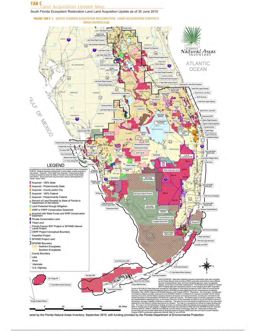
73
74 Appendix A CERP Project Information Appendix B CERP Program Coordination Appendix C Scientific Initiatives APPENDICIES Appendix D Status of Other South Florida Everglades Ecosystem Restoration Projects Appendix E Updated Cost Estimates by CERP Project CERP 2010 Report to Congress i
75 THIS PAGE Intentionally Left Blank ii
76 APPENDICIES Table of Contents APPENDIX A CERP PROJECT INFORMATION A.1 AQUIFER STORAGE AND RECOVERY REGIONAL STUDY A-1 A.2 BISCAYNE BAY COASTAL WETLANDS A-1 A.3 BROWARD COUNTY WATER PRESERVE AREAS A-2 A.4 CALOOSAHATCHEE RIVER (C-43) WEST BASIN STORAGE RESERVOIR A-2 A.5 C-111 SPREADER CANAL A-3 A.6 WATER CONSERVATION AREA 3 DECOMPARTMENTALIZATION AND SHEETFLOW ENHANCEMENT (DECOMP) A-3 A.7 EVERGLADES AGRICULTURAL AREA RESERVOIR A-4 A.8 LAKE OKEECHOBEE WATERSHED A-4 A.9 LOXAHATCHEE RIVER WATERSHED RESTORATION PROJECT A-5 A.10 SOUTHWEST FLORIDA FEASIBILITY STUDY A-6 APPENDICIES APPENDIX B CERP PROGRAM COORDINATION B.1 PROGRAMMATIC REGULATIONS B-1 B.2 EVOLUTION OF THE INTEGRATED DELIVERY SCHEDULE B-2 B.3 RECOGNIZING CULTURAL RESOURCES B-2 B.4 MASTER RECREATION PLAN B-2 B.5 INTERAGENCY MODELING CENTER B-3 B.6 PUBLIC OUTREACH AND ASSISTANCE B-4 B.7 INFORMATION AND DATA MANAGEMENT B-7 B.8 QUALITY ASSURANCE OVERSIGHT TEAM B-8 B.9 ENVIRONMENTAL AND ECONOMIC EQUITY B-8 B.10 PROGRAM COORDINATION FINANCIAL COSTS B-9 B.11 OUTLOOK FOR ECONOMIC, TOURISM, RECREATION AND OTHER BENEFITS B-10 APPENDIX C SCIENTIFIC INITIATIVES C.1 INCORPORATION OF ADAPTIVE MANAGEMENT C-1 C.2 RESTORATION COORDINATION AND VERIFICATION C-1 C.2.1 Planning and Evaluation C-1 C.2.2 Adaptive Management Program C-2 C.2.3 Adaptive Assessment and Monitoring C-2 C.3 INTERIM GOALS AND INTERIM TARGETS C-4 C.4 METHODS FOR ASSESSING PERFORMANCE AND PROVIDING RECOMMENDATIONS FOR IMPROVEMENT C-5 C.5 NEW SCIENCE C-7 C.6 NON-INDIGENOUS (INVASIVE/EXOTIC) SPECIES C-8 C.7 IMPACT OF CLIMATE CHANGE AND SEA LEVEL RISE C-9 C.8 EXPECTATIONS FOR THE SOUTH FLORIDA ECOSYSTEM RESTORATION OVER THE NEXT FIVE YEARS C-10 C.8.1 RECOVER Activities Anticipated over the Next Five Years C-10 C.8.2 Addressing Invasive and Exotic Species C-12 C.8.3 Incorporating Climate Change and Sea Level Rise C-13 CERP 2010 Report to Congress iii
77 APPENDIX D STATUS OF OTHER SOUTH FLORIDA ECOSYSTEM RESTORATION PROJECTS D.1. THE FOUNDATION PROJECTS D-1 D.1.1 Modified Water Deliveries to Everglades National Park Project D-3 D Square Mile Area D-3 D Tamiami Trail Modifications D-4 D Spreader Swale Pilot Test along Tamiami Trail D-4 D Conveyance and Seepage Control Features D-4 D Everglades Restoration Transition Plan D-4 D.1.2 Kissimmee River Restoration D-5 D.1.3 Central and Southern Florida: Modifications to the C-111 Project (South Dade) D-6 D.1.4 Central and Southern Florida: West Palm Beach Canal Stormwater Treatment Area-1E/C-51 West D-7 D.2. EVERGLADES AND SOUTH FLORIDA: CRITICAL RESTORATION PROJECTS PROGRAM D-7 D.3. ADDITIONAL SOUTH FLORIDA ECOSYSTEM RESTORATION PROJECTS D-9 D.3.1Federal Initiatives During the Past Five Years D-9 D.3.2 State and Local Initiatives During the Past Five Years D-9 D.3.2.1Northern Everglades and Estuaries Protection Program D-9 D C-43 Water Quality Treatment and Testing Facility D-9 D Fisheating Creek Feasibility Study D-10 D Hybrid Wetland Treatment D-10 D Local Cost-Share Projects with Martin County D-10 D Everglades Agricultural Area Stormwater Treatment Area Expansion D-11 D L-63N Canal (Taylor Creek) Aquifer Storage and Recovery Project D-11 D Seminole Tribe Brighton Reservation Aquifer Storage and Recovery Pilot Project D-11 APPENDIX E UPDATED COST ESTIMATES BY CERP PROJECT E-1 LIST OF APPENDIX TABLES Table A-1: Comprehensive Everglades Restoration Plan Project Status A-7 Table B-1: Comprehensive Everglades Restoration Plan Expenditures for Program Coordination B-10 Table C-1: Comprehensive Everglades Restoration Plan Adaptive Assessment and Monitoring Expenditures through Fiscal Year 2009 C-6 Table D-1: State Initiatives Update Past Five Years D-12 Table E-1: Updated Cost Estimates By CERP Project E-1 LIST OF APPENDIX FIGURES Figure D-1: Other South Florida Everglades Ecosystem Restoration Projects D-2 iv
78 APPENDIX A CERP PROJECT INFORMATION Section 601(h) of Water Resources Development Act (WRDA) 2000 and (c) of the Programmatic Regulations set forth reporting requirements for the Comprehensive Everglades Restoration Plan (CERP). These include providing descriptions of planning, design, and construction work completed during the five-year period covered by the report. As a quick reference, Table A-1 provides a listing of CERP project accomplishments to date. Under normal procedures, in order for a CERP project to begin construction, it must be authorized and have a signed project partnership agreement. Projects that are in construction, authorized or have signed Project Partnership Agreements are discussed in the main body of the document. The projects discussed below are in various stages of the U.S. Army Corps of Engineers (USACE) planning process or are studies that result in a report. The progress these projects have made over the past five years is discussed below. APPENDIX A CERP PROJECT INFORMATION A.1 AQUIFER STORAGE AND RECOVERY REGIONAL STUDY CERP includes use of Aquifer Storage and Recovery (ASR) technology on an unprecedented scale. This technology involves collection and treatment of excess surface waters that are then stored in underground aquifers for later recovery. Although ASR technology has been used successfully in Florida since 1983, concerns have been expressed about the proposed use of large-scale ASR in south Florida. Many of these concerns were outlined in a report prepared by the ASR Issue Team of the South Florida Ecosystem Restoration Task Force (SFERTF). The ASR Regional Study was designed to answer many of the questions concerning the feasibility of full-scale ASR implementation. An interim report (June 2008) summarized efforts from Hydrology, water quality, engineering and eco-toxicological data were collected successfully during the recharge phase of cycle-1 in the Kissimmee River ASR Pilot Facility. Additional data collection, modeling, assessment and evaluations will continue through 2012 with a final summary report summarizing the feasibility for the regional use of ASR technology for CERP. A.2 BISCAYNE BAY COASTAL WETLANDS This project will expand and restore the wetlands adjacent to Biscayne Bay in Miami-Dade County, enhancing the ecological health of Biscayne National Park. In February 2008, the project was divided into two phases. Phase I consists of the design and construction of three essential components: Deering Estates Flowway, Cutler Ridge Wetlands, and L-31 East Flowway to restore the quantity, quality, timing, and distribution of freshwater to Biscayne Bay and estuary and Biscayne National Park. The entire project will capture, treat, and redistribute freshwater runoff from the watershed into Biscayne Bay, expand spatial extent and connectivity of coastal wetlands, and provide improved recreational opportunities in Biscayne Bay and adjacent wetlands. It will also improve salinity distribution near the shoreline helping to reestablish productive nursery habitat for shrimp and shellfish. Miami-Dade County has already constructed a portion of the proposed Deering Estates Flowway. The project team completed a draft Project Implementation Report (PIR) for Phase I and published it in the Federal Register in February As discussed in section the South Florida Water Management District (SFWMD) completed construction on L-31 Culverts in 2010 and began construction on Deering Estates. Cutler Wetlands is scheduled to begin construction in CERP 2010 Report to Congress A-1
79 A review is currently under way in response to the request by the local sponsor for a policy change regarding cost-sharing for treatment of agrichemical soils within the project footprint. Upon receipt of policy decision, the project will proceed with either a re-write of the PIR or a presentation to the Civil Works Review Board. A.3 BROWARD COUNTY WATER PRESERVE AREAS The Broward County Water Preserve Areas project contains three of the ten initially authorized projects identified in WRDA 2000: Water Conservation Area 3A/3B Levee Seepage Management, C-11 Impoundment and Stormwater Treatment Area (STA), and C-9 Impoundment and STA. The project was refined in the final PIR signed by the USACE District Engineer in June However, completion of the PIR and design of project features was suspended pending resolution of the land crediting policy change request from SFWMD. The land crediting policy has since been resolved. The PIR is being rewritten based on the changes to the Master Agreement as well as the cost updates for the real estate policy change and to reflect construction cost changes. Once the changes are incorporated, an Independent External Peer Review will be scheduled and conducted prior to submitting this project for WRDA consideration. The project is designed to enhance the buffer between residential development and protected Everglades wetlands, capturing and diverting stormwater runoff and reducing underground seepage from the Everglades. It consists of three components all located along the eastern edge of Water Conservation Area 3A/3B in Broward and Miami-Dade counties. (1) Water Conservation Area 3A/3B Seepage Management Area is a 14-mile-long tract of wetlands adjacent to the Everglades. Increasing the water levels in this area will reduce groundwater seepage from Water Conservation Areas 3A and 3B. (2) C-11 Impoundment is a 1,500-acre, above-ground impoundment capable of holding a water depth up to approximately four feet. It will receive diverted untreated stormwater from the western C-11 watershed, which would otherwise enter Water Conservation Area 3A. The impoundment pool will also assist in reducing groundwater seepage to improve groundwater levels in the Everglades. (3) C-9 Impoundment is a 1,650-acre, above ground impoundment capable of holding a water depth of up to approximately four feet. It will capture excess stormwater from the western C-11 watershed. If the impoundment has capacity and there are no flows from the C-11 Basin, then excess stormwater from the western C-9 Basin will be pumped into the impoundment for temporary storage and release. The impoundment will assist in reducing groundwater seepage from the adjacent Seepage Management Area and Water Conservation Area 3B. State Expedited Efforts While the PIR was suspended, the state moved forward under its expedited program to complete the Basis of Design Report for the Water Conservation Area 3A/3B Seepage Management Area and the C-9 Impoundment. On C-11 Impoundment, the preliminary project design is 60 percent complete. The remaining design and construction for all three Water Preserve Areas components have been transferred to the USACE. A.4 CALOOSAHATCHEE RIVER (C-43) WEST BASIN STORAGE RESERVOIR A Final PIR has been completed and the Chief of Engineers Report was signed in March This project proposes a 170,000 acre-feet reservoir to capture excess C-43 Basin runoff and store water releases from Lake Okeechobee and then release water to the Caloosahatchee Estuary when needed. The reservoir will also help to improve water quality by reducing salinity and nutrient impacts of runoff and improving environmental water supply deliveries to the Caloosahatchee Estuary. A-2
80 A.5 C-111 SPREADER CANAL This project is being implemented via two PIRs (a Western PIR and an Eastern PIR). The draft integrated PIR and Environmental Impact Statement for the Western PIR was completed in A signed Chief of Engineers Report is expected in fiscal year As discussed in section 2.1.2, a portion of this project is being expedited by the state. The PIR includes a 590-acre Frog Pond detention area and a second detention area (Aerojet Canal); with each having a 225 cubic feet per second pump station. These features will create a mound of groundwater to the south and west, which will prevent groundwater seepage out of Everglades National Park (ENP). Preventing groundwater seepage out of ENP will improve the quantity, timing and distribution of flows to Florida Bay via Taylor Slough. Hydroperiods and hydropatterns within wetlands of the Southern Glades and Model Lands will be improved by construction of a new water control structure in the lower C-111, incremental operational changes at existing structure S-18C, changes in operations at the existing structure S-20, construction of a plug at structure S-20A, and installation of ten earthen plugs in the C-110 Canal. As mentioned in section 2.1.3, in addition to the Western PIR efforts, an integrated Design Document Report/Environmental Assessment was prepared for the C-111 Spreader Canal Design Test. The test consists of operating a small scale spreader canal and monitoring the effects on groundwater and surface water flows. This data will be used in the development and analysis of alternatives for the Eastern PIR and will help determine the location for the Eastern PIR s full-size spreader canal, minimize impacts to private lands, and maximize restoration results. APPENDIX A CERP PROJECT INFORMATION The integrated report on the design test was open for public comments between August and September The design test survey and hydraulic design were completed in 2008 and the scope of work for the test was completed in January 2009 with a final document dated July A contract for the design test was awarded and operation of the test began in February 2010; testing will continue for two years. A.6 WATER CONSERVATION AREA 3 DECOMPARTMENTALIZATION AND SHEETFLOW ENHANCEMENT (DECOMP) At a June 2008 Feasibility Scoping Meeting, the Project Delivery Team recommended an Incremental Adaptive Restoration strategy for the DECOMP project. An initial plan formulation summary was drafted and RECOVER has completed its performance measure consistency review. Conceptual alternatives were modeled using the South Florida Water Management Model to determine which segment(s) of the Miami Canal yielded the most benefits when backfilled. The RMA-2 (a model developed by Resource Management Associates for the USACE in 1973) was used to determine optimal plug length and spacing given variable fill quantities. These model results, along with additional considerations, were used to formulate a preliminary array of alternatives. The Project Delivery Team used a structured screening process to reduce the preliminary alternatives to an array of six to be further analyzed using the Regional Simulation Model. The next step will be for the team to work on the modeling and evaluation of the final array of alternatives. Due to the uncertainties surrounding the physical impacts associated with DECOMP, a temporary field test will be implemented to investigate the design of features for restoring sheet flow and for removing barriers to habitat connectivity in Water Conservation Area 3. This test (also known as a Physical Model) is important because there are critical questions regarding design and effectiveness of decompartmentalization features that the project team cannot answer with current knowledge or computer simulation models. The DECOMP Physical Model will gather data to better understand the hydrological and ecological effects associated with different types of canal and levee modifications to benefit the Everglades, and to better understand how to design effective project features. CERP 2010 Report to Congress A-3
81 The DECOMP Physical Model will take place along a small portion of the L-67A Levee and L-67C Canal and Levee in Water Conservation Area 3 in northern Miami-Dade County approximately ten miles north of S-333. It consists of culverts in the L-67A Levee, a gap in the L-67C Levee and the complete and partial backfilling of segments of the L-67C Canal. These features will provide a controllable hydrologic connection between Water Conservation Area 3A and Water Conservation Area 3B delivering pulsed flows at velocities of at least three centimeters per second over a period of days. DECOMP Physical Model data and assessment of the effects of pulsed flows on hydrology, transport, vegetation and wildlife will guide planning, design and operational guidance for alternatives for both PIRs 2 and 3 of the DECOMP project. The entire DECOMP Physical Model includes planning and evaluation of test alternatives in an Environmental Assessment, baseline monitoring, installing test features, operation, post-installation monitoring and removal of all features following the test period. The Environmental Assessment for the DECOMP Physical Model was completed in April 2010 and installation is scheduled to begin in mid Data will be gathered over approximately four years. The USACE designed the project to be reversible so that following the testing; the area will be returned to its pre-test condition. A.7 EVERGLADES AGRICULTURAL AREA RESERVOIR The purpose of this project is to improve the timing of environmental deliveries to the Water Conservation Areas, including reducing damaging flood releases from the Everglades Agricultural Area (EAA) to the Water Conservation Areas. The features will also support reducing Lake Okeechobee regulatory releases to the estuaries, meeting Everglades Agricultural Area irrigation and Everglades natural system water demands, and mitigating flood risk for the Everglades Agricultural Area. The Tentatively Selected Plan (February 2006), features a reservoir impoundment with a maximum normal pool storage depth of 12.5 feet with approximately 31,000 acres of above-ground surface area. The reservoir is divided into two parts, Cell A-1 and Cell A-2, approximately 190,000 and 170,000 acre-feet in size, respectively. In December 2006, program managers recommended that the Phase 1 PIR should be modified to focus on implementation of Cell A-1 (the 190,000 acre-feet storage project and associated features). Work on the CERP project implementation report was suspended concurrently with the suspension of construction by the SFWMD on Cell 1 as discussed below. Once the legal issues are resolved, the strategy to meet the remaining needs of this area will be reassessed. State Expedited Efforts Under its expedited projects program the SFWMD awarded the EAA Reservoir construction contract in June 2006, with a five-year construction schedule for an above-ground reservoir for water storage, with a capacity of 190,000 acre-feet at a maximum depth of 12.5 feet. The reservoir (known as A-1) has been planned to be part of the larger CERP EAA Storage Reservoirs project and will be constructed on 16,700 acres of land north of STA 3/4. However, the reservoir construction was suspended by the SFWMD Governing Board on June 1, 2008 (due to litigation) and the construction contract was terminated on November 30, To date, the seepage canal excavation phases have been completed and approximately 20 percent of the materials to build levee components have been produced. A.8 LAKE OKEECHOBEE WATERSHED The Lake Okeechobee Watershed is one of CERP s largest projects and affects approximately 1,800 square miles. It consists of four major planning areas, based on the four major tributary systems that naturally drain the lower portion of the watershed into Lake Okeechobee. The purpose of Lake Okeechobee Watershed is to increase aquatic and wildlife habitat, regulate extreme highs and lows in lake staging (water levels), reduce phosphorus and other nutrient loading to Lake Okeechobee and A-4
82 reduce damaging releases to the surrounding estuaries. In addition, the project will focus on rehydrating wetlands in and around the areas north of the lake and improve the ecological health of Lake Istokpoga. The project has been delayed, since 2005 due to unresolved issues. The draft PIR will be completed and circulated for review following the resolution of the issues. State Expedited Efforts As discussed in section 2.1.2, the state is constructing the Lakeside Ranch Stormwater Treatment Area. Construction for the STA North and the S-650 Pump Station (Phase 1) has begun. Design for Phase II (STA South and S-191A Pump Station) is currently under way. A.9 LOXAHATCHEE RIVER WATERSHED RESTORATION PROJECT The Loxahatchee River Watershed Restoration Project (formerly known as the North Palm Beach County-Part 1 Project) is located in northeastern portions of Palm Beach County and Southern Martin County and covers approximately 180,000 acres. The project, as identified in CERP (1999), is made up of six main components: APPENDIX A CERP PROJECT INFORMATION 1. Pal-Mar and J.W. Corbett Wildlife Management Area Hydropattern Restoration 2. L-8 Basin Modifications 3. C-51 and L-8 Reservoir 4. Lake Worth Lagoon Restoration 5. C-17 Pumping and Treatment 6. C-51 Pumping and Treatment The purpose of the Loxahatchee River Watershed Restoration Project is to improve the overall quantity, quality, timing and distribution of freshwaters, increase the spatial extent of natural areas and restore hydrologic and ecological connectivity, all in an effort to improve the ecosystem function across the entire area. The SFWMD has the technical lead on the project. The Feasibility Scoping Meeting was completed in A tentatively selected plan was identified by the project delivery team in June 2010 and the team is working towards the Alternative Formulation Briefing. In partnership with the City of West Palm Beach, Indian Trail Improvement District, and Palm Beach County, the SFWMD completed the L-8 Reservoir Testing project at the Palm Beach Aggregates site in March This test project provided the technical basis to confirm that the rock mining pits at the Palm Beach Aggregates site could be effectively used for water storage. Based on the data collected during this project, the SFWMD, in partnership with the Florida Department of Environmental Protection, moved forward with acquiring this storage facility in Additionally, in 2008, the SFWMD conducted a test of the Flowway 1 concept to move regional water to the Loxahatchee River. The test was initiated in April 2008, but had to be suspended due to drought conditions and was re-started in July Even though L-8 Reservoir water was unavailable at the time of the test, the test confirmed that if water is available from the regional sources of Water Conservation Area-1 or the L-8 Reservoir, the G-161 and downstream structures can be successfully operated to deliver the required flows to the Northwest Fork of the Loxahatchee River. By utilizing a phased approach to the construction, approximately 18,000 acre-feet of discharge capacity has been made available for interim water management benefits in the L-8 Basin area and this capacity will increase every year until full completion. CERP 2010 Report to Congress A-5
83 State Expedited Efforts As discussed in section 2.1.2, the L-8 Reservoir will improve water levels in the Loxahatchee Slough and increase freshwater deliveries to the Northwest Fork of the Loxahatchee River during dry periods by providing 47,000 acre-feet of water storage. Although components that are complete include installation of the G-160 and G-161 structures, design and construction of additional pumping capacity will be necessary to fully utilize the storage. The design and construction plan for L-8 additional storage capacity is complete. A.10 SOUTHWEST FLORIDA FEASIBILITY STUDY The Southwest Florida Feasibility Study was authorized to provide a framework to address the health of aquatic ecosystems; water flows; water quality; water supply; flood protection; fish and wildlife; biological diversity; and natural habitat. The study area encompasses 4,300 square miles including eleven municipalities. The study boundary also corresponds to the SFWMD Lower West Coast Water Supply Plan area. The non-federal sponsor and the USACE determined that completion of the report as a watershed plan would accomplish the requirements of the Comprehensive Everglades Restoration Plan. The Project Delivery Team is currently repackaging the Integrated Feasibility Report into a watershed plan to be submitted to Congress in The Southwest Florida Comprehensive Watershed Plan will outline potential projects with both federal and local interest that accomplish the goals authorized with the Southwest Florida Feasibility Study. The implementation of the Southwest Florida Comprehensive Watershed Plan will require identification of non-federal sponsors as projects are designed and authorized for construction. A-6
84 TABLE A-1: COMPREHENSIVE EVERGLADES RESTORATION PLAN PROJECT STATUS Note: All items checked in the following table (Table A-1) are complete unless otherwise stated. APPENDIX A CERP PROJECT INFORMATION CERP 2010 Report to Congress A-7
85 THIS PAGE Intentionally Left Blank A-8
86 APPENDIX B CERP PROGRAM COORDINATION Successful implementation of CERP requires that consistent guidance be provided across the many plan elements and planning teams. This guidance includes strategic direction for the sequence of project implementation, resource allocation, and goals against which progress of the restoration is measured, and the feedback processes to identify and address any shortfalls in progress. The process to provide this guidance is referred to herein as program coordination. This includes efforts related to the Programmatic Regulations, the Integrated Delivery Schedule, and several program level activities which span multiple projects and system-wide issues. For each of these areas, work completed during the last five years and work anticipated over the next five years is described in the sections below. Over the next five years, integration will continue to be a mainstay with numerous federal and state agencies including the SFERTF. Ongoing coordination and participation with other initiatives, such as the finalization of the White House Council on Environmental Quality recently proposed National Objectives, Principles and Standards for Water and Related Resource Implementation Studies (December 3, 2009) will undoubtedly interface with the large CERP program. Public and stakeholder engagement has been and will be instrumental in the future success of the CERP program. APPENDIX B CERP PROGRAM COORDINATION B.1 PROGRAMMATIC REGULATIONS The Programmatic Regulations published in 2003 included clarification of the requirements from WRDA 2000 as well as additional requirements related to the implementation of CERP. As noted in the 2005 Report to Congress, the SFWMD and the USACE had developed six draft Program- Wide Guidance Memoranda, a draft Pre-CERP Baseline, a draft Initial CERP Update, and a Master Implementation Sequencing Plan in consultation with their federal, state and tribal partners and the SFERTF. The Six Program Wide Guidance Memoranda continue to be revised and updated to reflect new information as it has become available. They are used as interim guidance for the various project delivery teams to ensure consistency among the various reports and projects. Also, the various aspects and requirements of PIR development and coordination as enumerated in the Programmatic Regulations are carried out for each project and report. As provided for in WRDA 2000 and in the Code of Federal Regulations Part of the Programmatic Regulations, the Secretary of the Army shall review, and if necessary, revise the regulations of this part at least every five years or, whenever the Secretary believes that such review and revision is necessary to attain the goals and purposes of the Plan. The revision process must follow the federal rule-making process; and the revised regulations will require concurrence by the Secretary of the Interior and the Governor of Florida before promulgation by the Secretary of the Army. In accordance with these requirements, the USACE, in partnership with the state and the Department of the Interior, formed an interagency review team in 2009 to conduct the review and update the regulations. This includes an open, public process to ensure all stakeholders have an opportunity to provide comment and input to any needed revisions to the regulations. It is anticipated that any revisions proposed to the regulations will be published in 2011 for public review and comment. Following that review, the final revision to the regulations will be developed in coordination with other agencies and interests as required. CERP 2010 Report to Congress B-1
87 B.2 EVOLUTION OF THE INTEGRATED DELIVERY SCHEDULE The IDS is a living document and will be updated as necessary to reflect major changes in program authority, funding, or other pertinent decisions. The latest IDS can be found in Chapter 2, Table 2-1. It was updated after consultation with the SFERTF, the Miccosukee Tribe, the Seminole Tribe, other state and local agencies, and stakeholders at large. Updates to the IDS are expected in the near future to reflect the full impact of the increased federal funding for restoration as provided through the 2010/2011 budget including the ARRA. The IDS will also highlight ongoing actions by the State of Florida and the SFWMD to advance implementation of portions of the Plan and continue the accelerated land acquisition program. Should the state s negotiations to acquire property in the EAA come to fruition, the impact of that acquisition and potential changes to CERP will also be assessed and addressed as appropriate. B.3 RECOGNIZING CULTURAL RESOURCES To deal with the complex issues pertaining to impacts on cultural resources from CERP projects, the USACE, Jacksonville District took the lead with its partners in Everglades restoration through the creation of a Cultural Resource Coordination Team. This team is comprised of various stakeholders that include the SFWMD, the State Historic Preservation Officer, the State Archaeologist, the National Park Service and Tribal representation. Over the past five years the team has met to coordinate activities for 40 projects. The goals of this team approach are to ensure project completion, reduce duplication of efforts, and facilitate an expedited decision making process for the identification of cultural resources within CERP project areas. The group approach ensures that the multitude of local, state, and federal regulations pertaining to cultural resources are met at various stages of project planning and implementation. In addition, the team approach ensures that proper relationships are maintained with federally recognized tribes as part of the State of Florida s and federal trust responsibility. One of the major components for meeting this responsibility is coordination of projects under Section 106 of the National Historic Preservation Act. As part of an ongoing dialog with the Miccosukee Tribe and the Seminole Tribe, consultation with appropriate tribal representatives occurs for upcoming and ongoing projects. Over the past five years, this working group has conducted nineteen Cultural Resource Surveys within the south Florida CERP project area. The group approach has also allowed the team to work towards consistency on survey methods and policy. The Cultural Resource Coordination Team will continue to meet to ensure that local, state, and federal regulations pertaining to cultural resources are met at the various stages of project planning and implementation. In addition, relationship building and communications will be maintained with federally recognized tribes as part of the State of Florida s and federal trust responsibility by regularly meeting with appropriate tribal representatives to discuss upcoming and ongoing projects. B.4 MASTER RECREATION PLAN A significant part of recreation in south Florida is water-based. As CERP projects are implemented, the impact to recreation opportunities will be addressed along with the additional recreation opportunities that may be made available by CERP. A Master Recreation Plan has been under development that will identify, by region, restoration compatible recreation suited for potential inclusion in CERP projects. This plan will ensure the public has the opportunity to directly enjoy the benefits from the Everglades restoration. The interagency team working on the plan has identified existing recreation opportunities as well as potential recreation opportunities on a regional basis. The Master Recreation Plan is a guidance document to be utilized by the project delivery teams for the incorporation of recreation planning, consistent with the goals and objectives of CERP during their site-specific design work. B-2
88 The Master Recreation Plan is expected at the beginning of FY Therefore, over the next five years, it is expected that there will be continued support to the project delivery teams during their planning phase to ensure that recreation planning is included and consistent with the goals and objectives of CERP. B.5 INTERAGENCY MODELING CENTER A collaborative state and federal interagency effort, the Interagency Modeling Center, was established in 2003 to provide a centralized pool of resources and expertise to promote greater efficiency and consistency in the hydrologic and ecologic modeling that supports CERP planning. It provides, coordinates, and oversees the modeling needs and efforts for CERP both at the Program Coordination level and at the regional level. Modeling needs for individual project analyses are addressed by project delivery teams and consultants, but are coordinated through the Interagency Modeling Center to ensure consistency with the regional model, for model selection, and appropriate application of project-level models. System-wide computer models are important tools used to simulate south Florida hydrology and water management, and to evaluate the system-wide performance of the plan. The primary regional model covering most of the CERP domain is the South Florida Water Management Model. Subregional models are used when finer detail for a portion of the CERP domain is needed, or when the project is outside the domain of the South Florida Water Management Model. Often, sub-regional models are used in conjunction with the South Florida Water Management Model. The Regional Simulation Model encompasses a family of next generation sub-regional models that are beginning to be applied to certain basins to provide more accurate representations of performance under CERP. Implementation of the Natural System Regional Simulation Model is intended to provide a superior representation of the pre-drainage system and replace the current Natural System Model which is based on the South Florida Water Management Model. APPENDIX B CERP PROGRAM COORDINATION The South Florida Water Management Model is being updated to extend the period of record, update land use, topography, and enhance the model code. It was ported from Unix to Linux to facilitate simulations on computer clusters which has dramatically reduced computer run-times for simulations. Since its inception, the Interagency Modeling Center has performed thousands of regional model simulations to support CERP projects and RECOVER evaluations; and has responded to hundreds of requests from CERP projects for review of modeling strategies, scopes of work and reports of project-level model applications. In addition, Interagency Modeling Center modelers provide liaison services to project delivery teams and RECOVER to facilitate their interaction. The next five years are expected to be a period of continued demand for regional and sub-regional model applications for planning and evaluation of CERP projects. Sub-regional implementations of the Regional Simulation Model will be completed and deployed in the Interagency Modeling Center for application to provide more accurate representations of the performance of CERP projects. Project-level modeling will continue to be coordinated by the Interagency Modeling Center to ensure consistency with regional models and for appropriate model applications. Ecological models which have been under development outside of the Interagency Modeling Center will be incorporated into the Interagency Modeling Center to facilitate the evaluation of ecological response to CERP projects. CERP 2010 Report to Congress B-3
89 B.6 PUBLIC OUTREACH AND ASSISTANCE Public outreach is a vital part of CERP. Involvement and information are primary components and continue to play a key role in CERP implementation. The primary objectives of outreach are to: (1) keep the public informed of the status of the program or project and key issues associated with restoration implementation, and (2) provide effective mechanisms for meaningful public participation during the restoration process. The USACE, the SFWMD and Florida Department of Environmental Protection have a multi-faceted CERP public outreach program. Outreach strategies seek two-way communication with all public sectors to broaden understanding and to instill a sense of stewardship among all Floridians and visitors. The partner agencies conduct outreach for system-wide issues at the program level as well as customized outreach for each CERP project. While program and project outreach activities are considered separate, there is often overlap of materials, tools and techniques. Creative methods engage diverse groups: from school children to retirees; from those who need very basic information to those who require highly technical and scientific information; those who are socially or economically disadvantaged; and those who need their information in other languages, such as Spanish or Creole. The agencies developed and executed a broad array of outreach involvement activities and information programs to include the general public, minority groups, small businesses, and specific stakeholder audiences. The program has included public meetings and workshops; news media relations; creative information products; environmental education; print, electronic, interactive and Internet materials; and many other programs and products to ensure the public is engaged and involved in CERP. The main focus of the outreach efforts is the 16-county central and south Florida region, the area most affected by CERP. Yet, outreach activities and products also reach many people throughout the State of Florida, nation and world. Highlights of this very diverse CERP outreach program include: Launched the successful environmental education curriculum The Journey of Wayne Drop to the Everglades in Since then, have distributed 200,000 English-language storybooks; 10,000 each Spanish and Creole storybooks; 10,000 DVDs and 5,000 teacher s guides. All materials are available online. The USACE participated in national and state teaching conferences to raise awareness of the products, as well as through other means. The book was updated in Program materials also include bulletin board characters and other related products. Developed and began distribution of Florida Panther Study materials, including curriculum for elementary and middle school students, a magazine and panther learning products. Executed Name That CERP Sound campaign to raise awareness about wildlife of the Everglades. Included an interactive game, Web products, buttons, a screensaver and a tray liner. Distributed more than 500,000 promotional products since 2005, which includes Earth squeeze balls, backpacks, wristbands, eco-friendly bags, fans, tattoos, beverage holders, hologram rulers, and many more. Products appeal to all ages and carry the CERP logo, web site and other information. Distributed 700,000 copies of the Community Outreach in Action newsletter since 2005, largely to African-American readers. Approximately two new issues are distributed per year. B-4
90 Distributed 200,000 copies of the Spanish-language Community Outreach in Action to predominantly Hispanic communities since The newsletter is distributed approximately once a year in Spanish. Both English and Spanish language versions are also placed online. Produced an electronic newsletter about Everglades restoration, which is distributed six times a year. The name changed from CERP Report to Everglades Report in 2008, and the tone shifted from outreach to more hard news. This is sent to an list, placed online, and 200 of each issue are printed for community events. (A total of 30 new issues have been created and distributed since 2005.) Participated with CERP displays and materials at more than 80 community-sponsored events, and in more than 60 classrooms. Developed a public information campaign to further diversify involvement in Everglades restoration. The Livin with the Waters program is about a fictitious African-American family living in south Florida. Components include comics, bookmark-calendars, activity books, and a script for play, which was performed in Miami-Dade County in New installments are released each February, in connection with Black History Month. APPENDIX B CERP PROGRAM COORDINATION Produced CERP screensavers for Kwanzaa each year since 2005, which apply the principles of Kwanzaa to Everglades restoration. Organize and host an event each May to diversify involvement and engage the Haitian communities in the Everglades restoration effort. In 2009, the USACE provided art lessons to students in an inner-city after-school program, with the original artworks later put on display in May. Translated presentations and other materials to Spanish and Creole, as needed. Organized and held CERP Earth Day events since Often these events involved collecting and displaying original artwork from local elementary schools. Since 2005, thousands of individual works of art have been created (on 4- by 4-inch paper tiles provided to the schools) and displayed in the community in April. Maintained a network of touch-screen kiosks in public places throughout the 16-county CERP area. Thousands of people use the interactive kiosks each year to learn about the Everglades. The complete presentation is available in English and Spanish; the introduction is also available in Creole in some kiosks. Held more than 40 public meetings or workshops for CERP and related topics and several well-attended groundbreaking ceremonies for various south Florida projects. Distributed more than 60 news releases and notifications about CERP and related topics. Created and distributed two popular CERP mobiles about animals of the Everglades and the Florida panther. Maintained a recorded and updated toll-free phone line: CERP-USA. The line is available in English or Spanish and callers can leave a name to receive free print information in the mail. Participated in the Service-Disabled Veterans Small Business Outreach Program by presenting topics on the South Florida Ecosystem Restoration program and ARRA funding. CERP 2010 Report to Congress B-5
91 Completely revamped the domain and continually update the official CERP Web site with a greater emphasis on multimedia tools to help convey complex information in easy-to-understand terms and the addition of more videos and interactive tools along with access to the public information product resources named above. Developed a mobile information van which has been in use since late The van operator has traveled thousands of miles to dozens of events with materials and a video presentation. It is in use many weeks per year focusing on CERP, Lake Okeechobee, and the Herbert Hoover Dike rehabilitation. Launched a billboard campaign in late 2009 about non-native plants and animals. Billboards started appearing around the State of Florida in 2010 as part of a public service campaign and tie into the existing Don t Let it Loose campaign. Continued to update segments for the Everglades Radio Network at which broadcasts along Alligator Alley. Developed a comprehensive historic exhibit on permanent display in the lobby at West Palm Beach headquarters of the SFMWD. Encompassing 15 panels, the exhibit tells the story of the Everglades ecosystem with a focus on water management -- in pictures and text in a timeline dating from prehistoric times through December An additional nine-paneled exhibit highlights the Kissimmee-Okeechobee-Everglades ecosystem with a snapshot in time of yesteryear, a synopsis of the impacts to the system and how this vast and unique ecosystem is being restored today. As required by Section 601 (k) of WRDA 2000, programs at the federal and state levels ensure that small and minority-owned businesses are aware of opportunities with the USACE and the SFWMD and are provided opportunities to participate in CERP contracting opportunities under Section 15 (g) of the Small Business Act (15 U.S.C. 644 (g)). The USACE and SFWMD developed a Public Outreach Program Management Plan for CERP between 2000 and 2003 with public input to describe long-range outreach goals throughout the life of CERP. The WRDA 2007 amended Section 601 (k) of WRDA 2000, to support those requirements with an allowance for the Secretary of the Army to expend up to $3,000,000 per fiscal year (beginning after September 30, 2004) for public outreach, education and business assistance. In addition to the CERP activities listed above, the SFWMD sponsored the Everglades: An American Treasure, a Newspapers-In-Education (NIE) printed curriculum; delivered to every 7th and 9th grader in Monroe, Miami-Dade, Broward and Palm Beach counties. The educational supplement is also used as the basis for annual teacher training workshops. Support materials at the workshops include curriculum for middle and high school teachers, along with Everglades restoration updates and other science-based information. In 2009, a popular field studies component was added to the workshops and conducted onsite at the Loxahatchee Impoundment Landscape Assessment (LILA). LILA is a working model of the Everglades ecosystem located at the Arthur R. Marshall Loxahatchee National Wildlife refuge. This 80-acre living laboratory developed in 2000 by the USACE, U.S Fish and Wildlife Service and the SFWMD supports CERP by defining the hydrology (water depth and flow) that sustains a healthy Everglades. This field opportunity, along with the Everglades: An American Treasure curriculum, creates an Everglades education package to meet a significant part of the CERP education outreach requirement. It is aligned with the Florida Sunshine State Standards and the Florida Comprehensive Achievement Test based studies. B-6
92 Between 2004 and 2009, the SFWMD sponsored 27 Everglades education workshops, directly reaching 515 teachers and more than 51,000 students. In 2009, a virtual LILA tour was developed to bring the Everglades into the classrooms of those who had to forego field trips due to economic restraints. The SFWMD launched a complete redevelopment of its existing Web site ( in 2009 with a completion date of July Realizing the internet is now a primary venue for public information, the agency is enhancing the site with a greater emphasis on multimedia with a focus on Everglades ecosystem restoration by renaming and repopulating a major section called Protecting and Restoring Ecosystems. Tapping in to social media connections (e.g., Twitter, Facebook, and YouTube) is another example of how both the SFWMD and USACE are constantly looking for opportunities to increase use and explore alternative communication methods in order to reach varied audiences. As projects start to break ground, it is expected that there will be even more interest and involvement for CERP outreach and assistance. Planning will continue on the specific CERP projects throughout the 16-county area, with each requiring local outreach efforts, particularly to socially and economically disadvantaged individuals or those having limited English proficiency. Pilot projects will conclude, requiring the communication of the results to the public. For many, CERP will become more tangible as construction activities increase, bringing associated job and contracting opportunities. APPENDIX B CERP PROGRAM COORDINATION B.7 INFORMATION AND DATA MANAGEMENT The CERP Information and Data Management Programmatic activity is a combination of information services and systems which support the CERP program. These services support the project and program level activities of CERP, as well as other South Florida Restoration Programs. The functional areas of CERP Information and Data Management services include, but are not limited to, infrastructure management, electronic document management, scientific and electronic data management, geographic information systems, quality control/quality assurance of data and World Wide Web management. The south Florida restoration effort operates a common information system, the CERPZone, used to collaborate during the planning, engineering, construction, and post-construction phases of the program. This system is accessible, upon request, to all Program/ Project Delivery Team members from the USACE, Jacksonville District, the SFWMD, and other federal, state, local, and tribal government agencies. This system allows sharing of information by all participating agencies thereby avoiding duplication, increasing efficiency, and providing reliable short term and long term repositories for CERP data. Over the last two reporting periods over twenty-five tools have been developed or made available in the CERPZone. The tools range from a document management system, to an internet accessible electronic storage/sharing area, to web-meeting tools, to tools for identifying and approving tasks for team members and contractors. The system currently has over 1000 users and is comparable to a computer system for a mid-size company. The Information and Data Management program is responsible for maintaining all the equipment needed to run this system, including the programming and equipment necessary for the public website EvergladesPlan.org. The program is also responsible for lifecycle management of all data and documents associated with CERP. A period of even more interest in the storage and retrieval of data for CERP is anticipated. As projects are constructed, monitoring of the performance of the project and its affect on the south CERP 2010 Report to Congress B-7
93 Florida system will require comparisons between data taken in previous years and recent data. This will likely lead to even more interest in the quality standards and procedures established for CERP by the Quality Assurance Oversight Team. As data is compared between pre and post construction, the quality standards and procedures will ensure that the data is comparable. As data is compared other issues may also arise that will need to be addressed. In addition, collaboration will become even more significant as projects move into construction and operations. B.8 QUALITY ASSURANCE OVERSIGHT TEAM As implementation of CERP moves forward, the critical need for establishing a Quality Assurance and Quality Control program to ensure the accuracy, precision, and reliability of CERP data and monitoring became evident. The Quality Assurance Oversight Team is an interdisciplinary, interagency body; however responsibility for Quality Assurance Oversight Team rests jointly with the USACE and the SFWMD, as the sponsoring agencies. The Quality Assurance Oversight Team is responsible for providing guidance on, and evaluating the implementation of, the CERP Quality Systems with the goal of providing guidance such that data collected meet or exceed the data quality objectives of each project. This includes developing and providing guidance on procedures, Quality Assurance/Quality Control requirements and data validation for CERP monitoring activities. The guidance can be found in the Quality Assurance System Requirements manual, which is available on the public Web site ( and through the CERP Guidance Memoranda. In addition, the Quality Assurance Oversight Team is the forum to develop consistency regarding data quality and the Quality Assurance/Quality Control processes among the various entities involved with hydrological, meteorological, water quality, and biological monitoring activities. In order to assure the quality of the data collected, the Quality Assurance Oversight Team reviews monitoring plans and scopes of work, performs laboratory audits and performance evaluations, and participates in field observations. Between six and ten laboratory audits were done each year starting in 2006 as well as at least one performance valuation. Several field observations in biological, ecological and hydrological areas were accomplished over the last three years. B.9 ENVIRONMENTAL AND ECONOMIC EQUITY The USACE (and other federal agencies) is required to make achieving environmental justice part of its mission by identifying and addressing, as appropriate, disproportionately high and adverse human health or environmental effects of its programs, policies, and activities on minority populations and lowincome populations and to develop an agency wide environmental justice strategy (59 F.R. 7629, Feb. 16, 1994). Additionally, programs, policies, and activities that substantially affect human health or the environment, operate in a manner that ensures that such programs, policies, and activities do not have the effect of excluding persons (including populations) from participation in, denying persons the benefits of, or subjecting persons to discrimination under, such programs, policies, and activities, because of their race, color, or national origin. The Environmental and Economic Equity (EEE) Program s purpose is to ensure that the CERP civil works projects are implemented in ways that do not result in disproportionate impacts on any community(s); and to assure that all Americans, including the unique cultural and ethnic diversity of south Florida s populations, live in safe, healthful and aesthetically and culturally pleasing surroundings. The CERP EEE Program Management Plan deals with the social, cultural, behavioral, historical and/or economic subjects involved with CERP. The plan s purpose is to maximize the potential benefits, both system-wide and project-specific, resulting from CERP activities and to minimize any adverse social or economic impacts that may arise. The USACE and SFWMD co-chair the CERP EEE Program. B-8
94 The USACE and the SFWMD attempted to identify acquisition policies, procedures and regulations which can be utilized by both agencies to procure services and award construction contracts. However, no simple unified procedures were found and consequently, each agency is using their own procedures. While the initial intent was to award a significant share of CERP construction projects to local small businesses, the magnitude of certain construction projects did not always make this possible. However, subcontracting and employing local small business community members was accomplished to the highest extent possible. The EEE program strategy therefore focuses on evaluating individual and cumulative system-wide changes in socio-economic, socio-ecological and human health effects to ensure that a healthy and safe environment exists, and that associated benefits are realized and maintained for all projects located in the south Florida Everglades -- including any impacts to minority populations or low-income populations. To that end, the partners will operate in accordance with the following principles: Promote partnerships with all stakeholders Identify and address the impacts of CERP activities on the people of south Florida including minority and low-income populations, and the Miccosukee Tribe and the Seminole Tribe APPENDIX B CERP PROGRAM COORDINATION Create an Advisory Board dedicated to ensuring that the EEE mandate is fulfilled within the USACE, Jacksonville District, and overseeing the implementation of, and compliance with socio-economic and environmental justice and Executive Order Coordinate with U.S. Environmental Protection Agency s Environmental Justice office, sponsors, stakeholders, other federal, state, and local offices Foster environmental and economic equity in future CERP and non-cerp projects, as appropriate Create and maintain an internal administrative process for EEE program activities The EEE Project Management Plan is undergoing revision that will result in continued effective community engagement and participation and should be finalized in Efforts in education and training, community engagement, partnering with community-based organizations, and providing assistance to small businesses will be refined and expanded to include gathering of updated census data and advanced training courses. In addition, contracting to small local businesses will be expanded for the longer term maintenance of constructed CERP projects. The EEE program may eventually cover both CERP and non-cerp projects. B.10 PROGRAM COORDINATION FINANCIAL COSTS As discussed in section 2.4.3, Program Coordination includes several program level activities as well as costs for the preparation of the Master Program Management Plan, the Master Agreement, the Agreement signed by the President and Governor, development of Interim Goals, report on Miami Dade ASR, reports to Congress occurring, at a minimum, every five years, annual reports to the public, and coordination with Army Audit and others on work-in-kind efforts by the sponsors. Other efforts which are essential to effectively executing the program and ensuring effective coordination among parties include Fish and Wildlife Coordination activities for program level actions, preparation of the special report on exotic species, and preparation of special agreements. Also part of these programmatic costs are the development of the more than 50 CERP Guidance Memoranda for project delivery teams, development and update of standard schedule and budget controls and procedures CERP 2010 Report to Congress B-9
95 such as standardized project templates and milestones. A breakdown of the costs for the program level activities Public Outreach, Environmental and Economic Equity, Information and Data Management, Interagency Modeling Center, Master Recreation Plan and RECOVER as well as program management is included in Table B-1. TABLE B-1: COMPREHENSIVE EVERGLADES RESTORATION PLAN EXPENDITURES FOR PROGRAM COORDINATION CERP Program Activity Actual Expenditures Through FY09 (1) (in 1,000s) (USACE and SFWMD) Program Management $ 132,291 Public Outreach $ 17,427 Environmental & Economic Equity $ 1,836 Information and Data Management $ 30,542 Interagency Modeling Center $ 34,535 Master Recreation Plan $ 2,751 RECOVER $ 39,887 TOTAL $ 259,270 Note: (1) Expenditures are through FY09 for the USACE; but, do not include SFWMD Work-in-Kind for FY08 or FY09. B.11 OUTLOOK FOR ECONOMIC, TOURISM, RECREATION AND OTHER BENEFITS CERP recognizes the interconnectedness of the natural system and development, by also providing for other water related needs of the region, including water supply and flood protection. This interconnectedness can be used to describe sustainability in integrating environmental and development issues. Sustainability development is meeting the needs of the present without endangering the ability of future generations to meet their own needs. Several state statutes directly or indirectly address sustainability. For example, Chapter 373, Florida Statutes, provides that minimum flows be established for watercourses to a limit beyond which would be harmful to the water resources or ecology of the area and water may be reserved for the protection of fish and wildlife or the public health and safety. The water reservation process is used to reserve the water created by a CERP project for the natural system. CERP implementation is also aimed at getting the water right -- at the right place, at the right time, in the right quantity and of the right quality. Getting it right enables a natural system to support more wading birds, alligator, panthers and other wildlife; restore short hydroperiod wetlands, improve flows to estuaries and help to control the spread of invasive exotic plants. CERP is helping to restore and support sustainable natural resource based economies that include hiking, biking, wildlife viewing, camping, hunting, fishing, and canoeing. Additionally, CERP will B-10
96 help to provide a sustainable water supply for new development that maintains and enhances water elevation and capacity by providing water storage capacity in areas where it has been diminished, without reducing flood management. CERP projects and non-cerp foundational projects work in tandem supporting restoration efforts by creating various benefits. These benefits include active and passive recreational activities, water storage, a more natural hydrology, restoration of natural areas that can now support fish and wildlife in numbers that can be safely harvested or just enjoyed. Acquisition of conservation land also supports economic sustainability. Protecting natural areas and maintaining fish and wildlife resources supports natural resources based businesses such as tourism or charter boat fishing, as well as groundwater recharge supporting water supply for other developed regions. One illustration can be made with a popular national pastime bird-watching. It is generating an estimated $477 million in retail sales in Florida every year. According to a state report, nonconsumptive bird use (non-hunting activities) supported more than 19,000 jobs in Florida in 2006, and wildlife viewing activities generated more than $3 billion statewide that year. APPENDIX B CERP PROGRAM COORDINATION In Economic Benefits of Land Conservation: A Case for Florida Forever (2009), the Nature Conservancy concluded that healthy native habitats and species are an integral component of the foundation of Florida s tourism industry Florida s single most important economic engine. During 2006, wildlife viewing alone had a total economic impact of $5.2 billion and supported a minimum of 51,000 jobs. Fishing and hunting accounted for a robust industry of more than $8 billion in 2006 and helped support almost 85,300 jobs and based on FY data, the Florida state park system had an overall direct economic impact of more than $1 billion on local economies throughout the state. Defenders of Wildlife A Preliminary Assessment of the Economic Benefits of Land Conservation Areas in Florida (2008) calculated economic impacts of ten areas protected through Florida Forever and other state acquisition programs. Total value of ecosystem services was estimated to be more than $1.8 billion per year and stated that Greater economic value can be gained from conservation areas that are well managed and restored and by preventing overly intensive uses that diminish the natural and economic values finding that the value of these services will increase in the future as fewer natural areas are available for protection. A case study by the same group entitled Economic Benefits of Conserving Natural Lands examined economic values from an 825-acre area in Collier County near Big Cypress National Preserve and Florida Panther National Wildlife Refuge. This study concluded that the economic value of the benefits flowing from these natural lands that accrue to humans in a given year (e.g. carbon sequestration, water supply, recreation, scenic views) ranged from $145 million to $315 million (in 2004 dollars). Highest values came from water provision (via recharge, through infiltration and percolation of rainwater that provides most of the public water supply. Another Defenders of Wildlife study Assessing the Wealth of Nature in Indian River County (2006) found that the annual value of ecosystem services derived from lands purchased by the county amounted to $23.4 million, including $19 million derived from freshwater wetlands, $3 million from coastal strand and $600,000 from forests and scrub. The annual value of services from all county public lands amounted to $768 million. A University of Florida, Gainesville, Food and Resource Economics Department Public Preferences and Economic Values for Restoration of the Everglades/South Florida Ecosystem report (1999 Milan, Hodges et al) found that the average household was also willing to pay $59 to $79 per year for the restoration of the Florida Everglades. CERP 2010 Report to Congress B-11
97 THIS PAGE Intentionally Left Blank B-12
98 APPENDIX C SCIENTIFIC INITIATIVES C.1 INCORPORATION OF ADAPTIVE MANAGEMENT Adaptive Management (AM) is a structured management approach that links science to decision-making in order to improve the probability of restoration success. AM is rooted in science and helps achieve goals and objectives by providing an efficient process to address the risk and uncertainty inherent within ecosystem restoration. Specifically, AM can help address questions about how best to achieve restoration goals or about the effects of proposed actions. AM encourages flexibility to be incorporated into plans and designs to account for uncertainty by providing options to adjust given actual future conditions. The AM process also encourages stakeholder engagement and interagency collaboration, which can lead to a better understanding of the issues that need to be addressed to implement individual projects or the overall CERP. By using AM to address uncertainty, information learned is used to adjust a program or project to better meet restoration goals, thus improving performance. APPENDIX C SCIENTIFIC INITIATIVES An AM program has been developed for CERP, and many of the critical components of AM are in place, including a scientifically rigorous monitoring and assessment program to analyze and understand responses of the system for implementation of CERP. More information on the Adaptive Management program is discussed in section C.2.2. C.2 RESTORATION COORDINATION AND VERIFICATION Restoration Coordination and VERification (RECOVER) is the scientific arm of CERP, ensuring that science remains a fundamental and overarching element throughout the ongoing planning and implementation of the Plan. RECOVER is a partnership among federal, state and local agencies, and tribal governments, designed to organize and provide the highest quality scientific and technical support to guide design and implementation of the Plan. RECOVER conducts evaluations and assessments and applies that information in ways that are most effective in supporting CERP objectives and to ensure that CERP system-wide goals and purposes are achieved. RECOVER communicates and coordinates the results of its evaluations and assessments, and provides opportunities for stakeholders to review its work products. Through its role in the AM program, RECOVER contributes to the ongoing process of assessment and refinement of the Plan. During this reporting period, RECOVER played a major role in developing and implementing system-wide tools and guidance, and also provided scientific expertise to project implementation. C.2.1 Planning and Evaluation In addition to its monitoring and assessment roles, RECOVER is also responsible for system-wide planning and evaluation. RECOVER evaluates, using numerical modeling and other tools, the performance of project and program plans and designs to ensure that they are fully linked to the systemwide goals and purposes of CERP. In its planning role, RECOVER identifies and provides analyses regarding potential improvements in the design and operation of CERP, consistent with the CERP objectives, and strives for consensus regarding scientific and technical aspects of CERP. Performance measures are planning tools used to determine the degree to which proposed alternative plans are likely to meet restoration objectives, or implemented plans have met restoration objectives. RECOVER developed a set of performance measures to evaluate CERP on a regional/system-wide basis, based on CERP-specific conceptual ecological models and the Florida Statutes. RECOVER has also continued to update and refine these performance measures as necessary throughout this reporting period. CERP 2010 Report to Congress C-1
99 RECOVER provides consistency across project teams by maintaining and updating the current CERP baseline and future without planning assumptions. RECOVER also coordinates with projects on planning conditions, and in particular coordinated with the DECOMP and EAA projects during this reporting period to better define what constituted conditions for the next added increment. In its regional evaluations RECOVER reviews every project s final array of alternatives and reports on how well each alternative performs in the context of the whole system. During this reporting period, RECOVER prepared regional evaluations for 12 CERP projects. In 2005 RECOVER published an Initial CERP Update report, which simulated CERP with updated models and input data, including recent climatic information, topography and land use projections. The Initial CERP Update report also contains performance measures and targets that have been revised based on continued research and improved understanding of species and ecosystem requirements. As expected, the hydrologic modeling results identified some of the same performance shortfalls and strengths in the Restudy. There were some areas where performance improved over the Restudy, but also some other areas that got worse. At the end of the technical update of the CERP model, it was recommended in the Initial CERP Update Report that a system-wide approach to address performance shortfalls be implemented and restoration targets for the natural system be reexamined based on independent lines of evidence (i.e. separate from model-based targets). C.2.2 Adaptive Management Program The CERP AM Program is a structured management approach that links science to decision-making in order to improve the probability of restoration success. Substantial progress has been made over the past five years in both creating an AM framework and integrating the principles and activities of AM into CERP at both the program and project levels. A CERP AM Strategy was developed in 2006 to outline a framework for linking monitoring and assessment activities to management decisions and to plan updates and revisions at both program and project levels. In 2007, Guidance Memorandum #6 identified assessment activities to support AM implementation. In 2010, a draft CERP AM Integration Guide was developed as a more detailed companion document to the CERP AM Strategy and is designed to assist managers/decision-makers, scientists, and CERP Project Delivery Teams understand and integrate AM into CERP planning, design, construction, operations, and maintenance. This guidance will assist project teams in developing AM plans (i.e., contingency plans), as required by 2009 USACE guidance interpreting Section 2039 of WRDA Project-level AM plans have been developed for several projects to outline how AM will be integrated. Those projects include: DECOMP - PIR 1, DECOMP - Physical Model, C-111 Spreader Canal, Biscayne Bay Coastal Wetlands, and Melaleuca Eradication and Other Exotics. C.2.3 Adaptive Assessment and Monitoring The AA&M Program, which is managed by RECOVER, is designed to provide system-wide and regional monitoring and assessment that ensures CERP goals and objectives will be met throughout implementation of the Plan. The CERP Monitoring and Assessment Plan (MAP, Part 1: Monitoring and Support Research) was developed in 2004 and includes 36 current monitoring components throughout the Everglades and south Florida ecosystem, using scientific expertise from 25 entities -- including federal, state, and local agencies, universities, non-governmental organizations, private contractors and others. The MAP was updated in 2009 to reflect changes in the monitoring plan which had occurred during the intervening five years. As such, the MAP 2009 represents a focused representation of current ongoing monitoring funded under the AA&M Program. Along with key monitoring, the MAP includes ongoing research focused on key hypotheses tied to ecosystem condition. C-2
100 The AA&M Program tightly links monitoring, assessment, and decision-making and ensures that scientific information collected from the monitoring program is useful to managers and decisionmakers. The last five years ( ) focused primarily on implementing the MAP and culminated with the development of the 2009 System Status Report. The System Status Report plays an important role within CERP by describing the scientific findings of the MAP and using this information to assess the progress towards meeting restoration targets and interim and long-term goals. With several CERP projects breaking ground in 2009 and 2010, the AA&M Program is poised to report ecosystem responses (both expected and unexpected) resulting from the first phase of CERP implementation. The science from the AA&M Program will be used to guide future planning, implementation, and operation of CERP. The accomplishments of the last five years ( ) can be parsed out into two categories: (1) key products; and (2) key scientific findings. Development of these products and implementation of the MAP have also led to a significant number of lessons learned, which will help guide the AA&M Program in the future. Key scientific findings are discussed in section Key products produced are discussed below. APPENDIX C SCIENTIFIC INITIATIVES The peer-reviewed Conceptual Ecological Models, published in a special issue of the journal Wetlands Vol. 25 (Issue 4) in 2005, illustrate links among societal actions, environmental stressors, and ecological responses and provide a basis for developing and testing hypotheses about natural system responses. As mentioned above, the MAP 2009 incorporates changes from and includes organization around hypothesis clusters instead of single hypotheses, flexibility to address project-level monitoring and assessment, and recognition of the challenges to sustainability of long-term monitoring programs. The latest version of the MAP ( is available on-line. The MAP-Part 2 outlines the process and necessary framework for assessing MAP data and addresses the integration of data at different spatial and temporal scales, the use of statistical methodologies for trend analysis and change detection, and the reporting process required to translate scientific findings into information useful to managers in the decision-making process. The System Status Report is a comprehensive report, currently projected to be published twice every five years by RECOVER, which addresses the overall status of the ecosystem relative to system-level hypotheses, performance measures, and restoration goals. The 2006 Report represented the initial application of the MAP-Part 2 for analyzing monitoring data collected by the MAP. The 2007 Report was RECOVER s first full technical assessment and provides estimates of pre-cerp conditions for ecosystem indicators monitored by the MAP. The 2007 Report clearly documented that sustained multi-year monitoring is a prerequisite for establishing sound estimates of pre-cerp conditions and trends, once projects are implemented. The 2009 Report provides an integrated assessment of MAP and non-map data. The assessment was synoptic, systematic, and spanned multiple spatial scales, and in some cases decades worth of information. The 2009 Report is posted on an interactive Web page accessible from that allows managers, stakeholders and scientists with varying interests and degrees of technical expertise to easily find the information they need. As suggested by the Committee on Independent Scientific Review of Everglades Restoration Progress, the AA&M program is implementing a data management approach that encompasses all MAP and relevant non-map data in coordination with Information and Data Management. This data management system provides fully functional data preservation, documentation, and access capabilities and partial functionality exists in the areas of data integration, processing, and modeling, which support the development of the System Status Report. RECOVER scientists also teamed with CERP 2010 Report to Congress C-3
101 the SFERTF s Science Coordination Group to develop the Stoplight Indicator Report, a suite of system-wide indicators that provide a broad assessment of the Everglades and south Florida ecosystem. The indicators were peer-reviewed and published in a special issue of Ecological Indicators. Future efforts will aim to combine the Stoplight Indicator Report with the System Status Report, providing a clear picture of both the status (e.g., stoplight analysis) of ecosystem indicators and the stressor-response functions (e.g., hypothesis cluster analysis) that explain indicator responses to CERP implementation. C.3 INTERIM GOALS AND INTERIM TARGETS Interim Goals (IGs) provide a means to evaluate the restoration success of the Plan, by tracking restoration performance and progress, providing a basis for reporting that progress at specified intervals of time, and for periodically evaluating the accuracy of predictions of system responses to the effects of CERP. The IGs can be expressed as either predictions of ecosystem response to CERP implementation, or as desired levels of performance and reflect incremental accomplishments towards achieving CERP goals. Interim Targets (ITs) are defined as anticipated incremental improvements in water supply (agriculture, municipal/industry) and other socioeconomic indicators over the course of CERP implementation. IGs/ITs were established by the Interim Goals Agreement (2007) and the Agreement on Interim Targets (2007). During the initial years of CERP, efforts focused on identification of indicators for IGs/ITs and development of tools to estimate progress. RECOVER s initial set of IGs and ITs was based on hydrologic modeling of the 1999 CERP plan. In February 2005, the RECOVER interagency team provided its final set of recommendations to the USACE, the U.S. Department of the Interior, and the SFWMD in The RECOVER Team s Recommendations for IGs/ITs for the Comprehensive Everglades Restoration Plan. An agreement between the Secretary of the Army, the Secretary of the Interior, and the Governor of Florida, containing the IGs, was completed in early The Interim Targets Agreement was signed by the Secretary of the Army and the Governor of Florida, also in The current Interim Goals Agreement contains 29 indicators as well as qualitative and quantitative interim goal statements that describe restoration goals for the hydrology, water quality and ecology of the Everglades ecosystem. The Interim Targets Agreement contains eight indicators describing goals for water volume, water supply, flood protection and surface water storage capacity. The status of these indicators is tracked by a number of monitoring programs, most importantly the RECOVER Monitoring and Assessment Plan. In addition to the RECOVER MAP, individual agency monitoring programs provide information on the status of these interim goals and interim targets indicators. Per the Programmatic Regulations, both IGs and ITs are to be reviewed, and progress reported, every five years: the current timeframe puts this review and reporting in The 2012 RECOVER Assessment Report is the technical vehicle for reporting on progress on achievement of the IGs. Information on progress toward restoration will be provided at that time to agency managers, the State and Congress, for consideration in the overall planning and implementation of CERP. Further description of the activities needed to complete this assessment is provided in the following sections. Many of the major components of the initial IGs are captured within the RECOVER System Status Reports and the SFERTF s stoplight indicators. However no explicit assessment of progress in C-4
102 meeting Interim Goals and Interim Targets occurred during the reporting period as of September 30, 2009, because no CERP full projects were as yet constructed. The National Research Council (NRC) continues to maintain interest in the future development of Interim Goals and Interim Targets, especially with the NRC s 2008 report highlighting that although the south Florida ecosystem has demonstrated significant resilience, it continues to decline as projects are delayed. Although there has not been a formal assessment of progress in meeting the IGs/ITs, RECOVER has made great progress in continuing to improve the predictability of expected environmental responses through work on performance measures and models and by using the data from the Monitoring and Assessment Plan (MAP) to refine predictive tools. Along with key monitoring, the MAP includes ongoing research focused on key hypotheses tied to ecosystem condition. In 2009 RECOVER finalized the Band 1 Report, which predicts and evaluates the performance of ten initial CERP projects by simulating projects and associated operations in order to answer the question How far towards restoration of the south Florida ecosystem will the Band 1 projects get us? The report revealed several important performance results to inform future CERP and non- CERP planning activities related to regional groupings of projects and AM. APPENDIX C SCIENTIFIC INITIATIVES Regional groupings of projects provide measurable predicted restoration benefits using RECOVER system-wide performance measures Using these groupings will help CERP staff evaluate major CERP project alternatives as part of the CERP project approval process AM provides the means to address uncertainties related to system-wide performance among multiple regional goals and objectives in order to optimize total system benefits Although projects to date have been implemented on a project by project basis, these findings are being considered in discussions on the IDS and project justification. C.4 METHODS FOR ASSESSING PERFORMANCE AND PROVIDING RECOMMENDATIONS FOR IMPROVEMENT After ten years of ongoing monitoring and research on the south Florida ecosystem, a large body of new scientific information is now available, and several efforts to employ this knowledge to better articulate the goals and objectives of CERP have been initiated. The AA&M Program is designed to provide system-wide and regional monitoring and assessment that ensures CERP goals and objectives will be met throughout implementation of the Plan. The cumulative expenditures for AA&M, including executing the MAP, are detailed in Table C-1. CERP 2010 Report to Congress C-5
103 TABLE C-1: COMPREHENSIVE EVERGLADES RESTORATION PLAN ADAPTIVE ASSESSMENT AND MONITORING EXPENDITURES THROUGH FISCAL YEAR 2009* Comprehensive Everglades Restoration Plan Adaptive Assessment and Monitoring Expenditures Through Fiscal Year 2009* (in 1,000s) Expenditures FY USACE SFWMD (1) Cumulative Expenditures 2001 $ $ $1, $ $ 1,139.0 $ 3, $ $ 3,429.8 $ 7, $ 3,455.6 $ 4,673.9 $ 15, $ 5,280.1 $ 5,240.8 $ 26, $ 5,477.2 $ 4,543.0 $ 36, $ 5,290.4 $ 6,033.2 $ 47, $ 4,250.9 (2) $ 51, $ 5,538.2 $ 57,323.6 TOTAL $ 31,701.3 $ 25,622.2 $ 57,323.6 Note: (1) SFWMD totals include cumulative creditable expenses (2) FY08 and FY09 SFWMD estimates are not as yet available. * Subject to audit The SFERTF has developed a series of information briefs that describe the synthesis of new science, current activities on climate change related to restoration, and strategic management and coordination, along with recommendations for controlling invasive exotic species. The Department of the Interior s ENP South Florida Natural Resource Center started a freshwater synthesis project that incorporates agency and stakeholder participation. And in an effort to better articulate the goals and objectives of CERP, a draft has been developed for a document, entitled Scientific and Technical Knowledge Gained in Everglades Restoration ( ), which will summarize the large body of monitoring and research, engineering advances, and modeling tools pertinent to the Everglades and south Florida ecosystem that have become available since This document will help inform a larger effort, known as the 2010 Shared Definition C-6
104 of Everglades Restoration which has been undertaken to fine-tune the goals and objectives of CERP that were somewhat uncertain at the time of authorization, and which were a basis for including AM in the Plan. In addition, continuing studies of the historical water movement patterns and geomorphology of the Everglades indicate that the Everglades were much wetter than originally thought, that is more water flowed south over more extended periods of time. Recent scientific synthesis efforts done by the SFERTF determined that additional flows to the Everglades and southern estuarine systems would be needed to achieve desired ecologic benefits (SFERTF New Science ). During a series of science workshops, a group of interagency scientists estimated the need for approximately 1.9 million acrefeet of average annual flows entering the Everglades Protection Area from the north. Based on this current scientific information, the Department of the Interior supports the need for approximately 1.9 million acre-feet of average annual flows as well as the need for additional storage. This information is now being considered in more detailed planning for restoring flows to the central Everglades as well as aiding in determining the freshwater needs of Florida and Biscayne Bays. APPENDIX C SCIENTIFIC INITIATIVES CERP and RECOVER monitoring have led to modified recommendations for managing Water Conservation Area 3A for apple snails and Everglades snail kite. CERP monitoring has provided science that has guided more wildlife-friendly reservoir designs. And ecosystem monitoring funded by CERP/RECOVER over the years has led to ecologist inclusion at weekly water management meetings where operational decisions are being made. The 2006 RECOVER report on IGs identified needed ecological models. These models serve as predictive tools for additions to the initial set of IGs. Goals need to be updated as improved scientific information and ecological modeling resulting from assessment and monitoring activities becomes available, or CERP Modification Reports deem necessary and reflect Plan implementation scheduling on the IDS. Information learned from the AA&M Program (described below), as well as information learned about system responses to CERP implementation, will aid in efforts to assess the Interim Goals and Interim Targets, provide evaluation of CERP progress, and revise Interim Goals and Interim Targets in the future. Total system performance measures should be incorporated and cause-and-effect patterns described in the Total System Conceptual Ecological Model (Ogden et al. 2005) are being used to develop these performance measures. These metrics would support the assessment of one or more hypotheses included in the MAP. By developing and making these explicit linkages, RECOVER would assure that the assessments being conducted in the System Status Report would provide the data required for evaluating the IGs. The System Status Report mechanism will provide the scientific base for the assessment and evaluation of the IGs. C.5 NEW SCIENCE Hydrological and ecological monitoring in the Everglades during the past decade has enabled us to characterize the ecosystem prior to CERP implementation. The AA&M program is designed to detect and understand both positive and negative ecological responses to changes in climate and water management. Positive changes provide evidence that many ecological components in the Everglades still have the capacity for restoration. The 2009 System Status Report provided the scientific information necessary to validate hypothesis clusters, and to begin to refine and assess IGs, and develop the flexibility required to evaluate the effectiveness of CERP restoration and support a robust AM program. The latest SSR and its findings can be found at: ssr_main.aspx. CERP 2010 Report to Congress C-7
105 C.6 NON-INDIGENOUS (INVASIVE/EXOTIC) SPECIES While efforts of the CERP and RECOVER programs have made it clear that restoration involves numerous factors (e.g., water quantity, water quality, abundance of flora and fauna), the potential impact of invasive species has emerged as a high priority for CERP planning. Invasion of south Florida s natural habitats by non-indigenous plant and animal species has significantly changed the ecosystem, particularly by displacing native species. Successful restoration of a healthy south Florida ecosystem will depend not only on modifications to the C&SF system, but also on control of invasive, non-indigenous plant and animal species. Many different techniques are used to control invasive plants and animals in south Florida (Langeland and Stocker, 1997; Wittenberg and Cock, 2001). Agencies typically use tools in an integrated fashion with the goal of minimizing impacts of invasive species by the most cost-effective and environmentally sound means. A detailed account of invasive species management tools and strategies is presented in Chapter 9 of the 2006 South Florida Environmental Report Volume I. An update and annotations for those species considered serious threats to Everglades restoration, with species impacts and a status report for high-priority species, are presented in Chapter 9 of the 2010 South Florida Environmental Report Volume I. There are two dozen priority species identified for the south Florida ecosystem. Numerous groups and agencies are involved with non-indigenous species management in Florida. In 2006, the SFWMD, USACE and the National Park Service co-hosted the Everglades Invasive Species Summit, where attendees recognized the need for a more defined commitment to cooperation among agencies and organizations. The Everglades Cooperative Invasive Species Management Area partnership was formalized in 2008 with a Memorandum of Understanding among the SFWMD, USACE, National Park Service, U.S. Fish and Wildlife Service and the Florida Fish and Wildlife Conservation Commission recognizing the need for cooperation in the fight against invasive species. Currently, Everglades Cooperative Invasive Species Management Area consists of 19 cooperators and partners, spanning the full spectrum of jurisdictions, including tribal, federal, state, local, and non-governmental conservation organizations. By sharing information, technology, and resources, they seek to elevate the successes of individual invasive species programs while simultaneously implementing regionally based control strategies. Early detection and rapid response of emerging threats is a central focus for Everglades Cooperative Invasive Species Management Area. Everglades Cooperative Invasive Species Management Area has conducted region-wide aerial mapping of invasive plants, created a web-based invasive species reporting system (available on drafted an Early Detection and Rapid Response Implementation Plan, and conducted rapid response efforts aimed at the controlling the sacred ibis (Threskiornis aethiopicus), Nile monitor; and most recently, kripa (Lumnitzera racemosa), an Asian tree found in mangroves and adjacent upland fringe. Coordination between multiple state and federal agencies has been a critical requirement as different species and projects are involved. Management of different species is often conducted by differentlyempowered agencies. For instance, the USACE manages floating weeds wherever they occur in Lake Okeechobee, since the mobile nature of these plants threatens navigation in the Okeechobee Waterway. The USACE mandates do not empower that agency to manage other invasive plants found elsewhere in Lake Okeechobee. The SFWMD manages these plants with internal and Florida Fish and Wildlife Conservation Commission funding. Special considerations arise, particularly with regard to endangered species. For example, during the past decade, Everglade snail kite (Rostrhamus sociabilis plumbeous) populations have fallen C-8
106 precipitously in Florida. Interagency coordination of aquatic plant control has included development of guidelines to avoid adverse impacts upon the bird s populations. Also, plant managers in Lake Okeechobee remain aware that control operations must avoid disturbing the endangered Okeechobee gourd (Cucurbita okeechobeensis okeechobeensis). From a regulatory perspective, invasive plant control efforts within SFWMD facilities, such as the STAs, need to proceed within the constraints and requirements of the Florida Department of Environmental Protection permits for their operation and mandates under the Everglades Forever Act. To complement existing south Florida invasive plant control programs, the development and spread of biological control agents, usually insects, will be increased under the CERP Melaleuca Eradication and Other Exotics Implement Biological Controls project. (See section for information about this project) APPENDIX C SCIENTIFIC INITIATIVES In December 2009, the USACE, Jacksonville District and federal and state partners unveiled a new public service campaign highlighting the statewide problem of invasive species at the U.S. Department of Agriculture Invasive Plant Research Laboratory in Fort Lauderdale. The campaign promoted public awareness and education and was called the Don t Let it Loose campaign. It was developed with support from the Department of the Interior U.S. Fish and Wildlife Service and the National Park Service bureaus. This campaign features the Nile monitor, the Burmese python and the sailfin catfish. A new Web site, and the CERP toll-free number (1-877-CERP-USA) provide additional information. This campaign and other education tools are also available at Billboard space was donated by the Florida Outdoor Advertising Association. C.7 IMPACT OF CLIMATE CHANGE AND SEA LEVEL RISE The exact pace, extent and magnitude of possible climate change impact on south Florida are largely unknown at this time. This is in part because of the difficulty to scale global and regional trend models down to predictions at the local level, the long timeframes involved, and the confounding effects of changing meteorological variables on habitats and species. Some climate change predictions point to extended droughts, uncertain recharge for the Everglades wetlands, reduced water availability and higher sea levels for south Florida. Even the more modest projections of sea level rise suggest a significant impact on the low-lying Everglades, the highly transmissive Biscayne Aquifer, and the near-coastal built environment. Everglades restoration is an important adaptation response to climate change. The impending natural resource alterations that will likely result from climate change should not be viewed as an excuse for delay or inaction, but rather as motivation to avoid irreversible losses and restore the health and natural resilience of the ecosystem (NRC 2008). Through an inter-agency effort the SFERTF developed an information brief that highlighted and synthesized current activities related to climate change and the relationship to ecosystem restoration ( /climate_change.html). In addition, scientists and planners involved in CERP are monitoring the latest developments in climate change. Federal, state and local agencies are involved in a variety of activities concerning climate change from hosting conferences to developing models to preparing papers and making recommendations on research and model needs. The USACE released interim guidance in 2009 concerning incorporating sea level change into USACE projects and expects further guidance to be released soon. The CERP Guidance Memorandum concerning sea level rise is being revised to take into account the latest guidance. The USACE is also working with partner agencies on a series of technical reports to facilitate collaborative information sharing, specifically regarding climate change sensitivity data and model development. CERP 2010 Report to Congress C-9
107 The Department of the Interior Climate Science Centers and Landscape Conservation Cooperatives form the cornerstone of an integrated approach to climate change science and adaptation. This strategy will serve the Department s land, fish, wildlife, water marine, tribal and cultural heritage managers, as well as our federal, state, local, tribal, non-governmental organization, private landowner, and stakeholder partners. The south Florida ecosystem is part of the Southeastern Climate Change Center and also the Peninsular Florida Landscape Conservation Cooperative. C.8 EXPECTATIONS FOR THE SOUTH FLORIDA ECOSYSTEM RESTORATION OVER THE NEXT FIVE YEARS IGs/ITs, established in the IGs Agreement and in the Agreement on ITs will be updated as improved scientific information and ecological modeling resulting from assessment and monitoring activities, or CERP Modification Reports deem necessary. They will also be revised to incorporate improved CERP modeling information produced and to reflect updated Plan implementation scheduling from the Integrated Delivery Schedule (IDS). Building upon the current effort to capture knowledge gained since 2000 (Scientific Knowledge Gained document), an initiative, the 2010 Shared Definition of Everglades Restoration, will be undertaken to fine-tune the goals and objectives of CERP. This effort is anticipated to be complete by the end of FY 2011 and results will be used to update IGs/ITs, as well as system-wide performance measures used by RECOVER to perform programmatic evaluations and assessments and by projects and operations to support plan formulation. C.8.1 RECOVER Activities Anticipated over the Next Five Years Over the next five years RECOVER contributions will continue to inform CERP planning and implementation efforts, particularly through its role in the CERP AM program. As information is gained from the AA&M Program on the ecosystem responses to CERP, it will be used to inform future planning and to guide adjustments. RECOVER efforts to conduct system-wide monitoring and assessment, compile new knowledge gained, and provide guidance on AM will remain essential. Evaluation and Planning During the next reporting period the following initiatives are anticipated to be undertaken by RECOVER Evaluation and Planning: Continue to review each project s final array of alternatives and report on how well each alternative performs in the context of the whole system for the remaining projects in the planning phase Conduct programmatic evaluations that evaluate the effects of CERP at the system scale, similar to what was done with the Band 1 Technical Report Continue to develop and refine performance measures to evaluate CERP on a regional/system-wide basis as necessary throughout this reporting period Following completion of the 2012 System Status Report and in compliance with the 2003 Programmatic Regulations requirement, RECOVER will develop an Assessment Report to evaluate whether the goals and purposes of the Plan are being achieved and to determine whether improvements to the Plan are warranted Continue to update CERP baseline planning conditions, as new information becomes available. RECOVER will also continue to coordinate with projects on the planning conditions Provide scientific support to be used as the basis for project sequencing contained in the IDS C-10
108 Implementation of the Adaptive Management Program As the CERP AM program matures from development to full implementation during the next reporting period several initiatives are anticipated to be undertaken. CERP has been implementing portions of an AM program at the programmatic level for several years, yet the pieces have never been recognized as components of a larger program. Consequently, a Programmatic AM Plan that will tie all the pieces of CERP together and indicate how they fit together is being developed. The final document is anticipated to be published during FY In addition, specific guidance will be provided on integrating AM into the existing planning process at both the project and program levels. The ultimate goal of the AM program is improved decision making through learning; in this case learning can be defined as using the information derived from the AA&M program to assist in decision-making and ultimately refinement of CERP. A specific process for linking results of the AA&M monitoring efforts (i.e., learning) into specific management actions is recognized as a need to be addressed during the next reporting period. An AM workshop was held with CERP leadership in spring 2010 to initiate this process, which could take several years to optimize, while management transitions from planning and design to a new approach to decision making and program implementation that incorporates new information from project-construction and operation. APPENDIX C SCIENTIFIC INITIATIVES To be in compliance with newly issued USACE guidance, AM plans will be prepared to the appropriate scope based on the complexity and scale of each CERP project at the appropriate time during the next reporting period. Each plan will be tailored specifically for the needs of each project, but at a minimum will outline the monitoring necessary to verify performance of the project and link new learning with future decision making regarding operational considerations and contingency options to optimize performance. Continuity of Adaptive Assessment and Monitoring Capitalizing on the progress made during the period, the next five years of the AA&M Program will be critical in providing scientific information about ecosystem responses to guide the planning and operation of CERP. This is especially important given the recent groundbreaking on a number of restoration projects in 2009 and Therefore, success in achieving the restoration goals of CERP depends on the long-term sustainability of the AA&M Program. In the context of AM, new scientific information will be used to update the conceptual ecological models, hypothesis clusters, performance measures, interim and long-term goals, and/or modeling tools. As the AA&M program was only authorized for ten years, reauthorization language has been proposed for a WRDA 2010 in order to be effective in providing the science for the AM process. In addition to continuing the progress made by the AA&M Program over the past five years, efforts will focus on the following: Continue development of System Status Reports beginning in 2012 As CERP projects are implemented, coordinate project-level monitoring plans with existing system-wide monitoring to guide project design and operation As CERP projects are implemented, utilize existing and future monitoring efforts to revise IGs and report on progress towards achieving them Continue to develop and evolve techniques to improve information-exchange between scientists and managers and improve coordination among science efforts Continue identification of management actions necessary to adjust CERP to meet desired performance expectations Continue appropriate levels of stakeholder engagement in development of AA&M Program products All of these activities will provide sound science necessary for implementation of the CERP AM Program. CERP 2010 Report to Congress C-11
109 C.8.2 Addressing Invasive and Exotic Species Non-indigenous species are rarely eradicated from the natural areas they invade, thus successful control can be defined as limiting the effects of biological invasions such that the basic physical and biological function of ecosystems, as well as their natural biological diversity, is not significantly impaired. Ecosystems resulting from restoration will contain new species groups and biotic interactions relative to their pre-disturbance state, and these new biotic components and interactions are certain to include exotic species (Norton, 2009). The CERP Melaleuca Eradication and Other Exotics project (section 2.1.5) is one example of what CERP is doing to address this potential issue. In the context of Everglades restoration, it is important to understand that invasive species will continue to exert pressure on native species and ecosystem functions in the restored condition and that without a long-term commitment to invasive species management, the accomplishments of restoration efforts might be greatly reduced. Fortunately, the importance of this issue continues to be elevated among state and federal agencies, public and private universities, state and federal task forces, and various other organizations. In fact, an inter-agency effort by the SFERTF developed an information brief on invasive exotics that outlined current strategies and efforts and proposed additional ways to control and manage invasive exotics ( brief/ Final_Apr_06_10_Exotics.pdf). The consensus of these parties is that control and management of invasive non-indigenous species is a critical component of ecosystem restoration in south Florida that involves all stages of a project from planning through design and construction to operations and maintenance. Also helpful will be the proposed revisions to the U.S. Department of Agriculture, Animal and Plant Health Inspection Service regulations on the importation of plants for planting and propagation (nursery stock), familiarly known as Q-37. These revisions propose to establish a new category of plants, Not Authorized Pending Plant Risk Analysis. A similar effort is under way for problematic animal species. In January 2009, new federal legislation was introduced (HR 669, Non-native Wildlife Invasion Prevention Act) that calls for the Secretary of the Interior to establish a risk assessment process to prevent the introduction into, and establishment in, the United States of nonnative wildlife species that will cause or are likely to cause economic or environmental harm or harm to other animal species health or human health. In the absence of proactive regulations that prevent introductions of potentially invasive species, agencies and the public must rely on the Lacey Act (42 U.S.C. 18), which allows the U.S. Fish and Wildlife Service to regulate international wildlife trade and addresses threats to native wildlife resources. In February 2009, Senate Bill 373 was filed, which amends the Lacey Act and declares large constrictor snakes as an injurious species. On December 10, 2009, the full Environment and Public Works Committee met to consider SB 373 and adopted an amendment in the nature of a substitute to add the nine species of constrictor snakes addressed in the October 13, 2009, U.S. Geological Survey risk assessment. A companion bill, HR 2811, was passed by the U.S. House of Representatives Judiciary Committee in July On March 11, 2010, the U.S. Fish and Wildlife Service announced that it would move forward with the official administrative process of banning the importation, export and interstate transport of nine species of constrictor snakes --- the same nine species being considered in SB373/HR2811. The Florida non-native wildlife bill signed into law on June 3, 2010 by the Governor and went into effect July 1, 2010, bans the species currently listed by the Florida Fish and Wildlife Conservation Commission as Reptiles of Concern (ROCs). The law adds language to civil and criminal penalties and allows the agency to levy fines. At their spring 2010 meeting, the Florida Fish and C-12
110 Wildlife Commission voted to move forward on draft rulemaking that would move the species currently listed as ROCs into the Conditional Species listing. This is a more restrictive listing that would prohibit personal possession; but would still allow commercial breeding and export out of Florida. This rulemaking is seen as implementing the provisions of the bill discussed above. C.8.3 Incorporating Climate Change and Sea Level Rise While there is uncertainty in the specifics of how climate change will manifest in south Florida, it is prudent to prepare now for the significant changes that lie ahead. Most importantly, we must recognize that the traditional planning method of assuming stationarity, that the future climate is likely to be similar to past, is obsolete. Land use and infrastructure planning in developed areas will require a longterm approach that recognizes increasing water levels. Gravity-based drainage infrastructure will be less effective at higher sea levels, increasing the risk of flooding, and placing greater emphasis on alternative water supplies. APPENDIX C SCIENTIFIC INITIATIVES A major theme for future land and water management in the face of climate change will be to restore and maintain the resilience of the Everglades ecosystem. Ecosystem resilience can be enhanced through increased water flows through the Everglades and increased storage. Increased flows into the southern estuaries may help reinstate widespread organic soil formation and maintain the freshwater head in order to mitigate the effects of sea level rise and saltwater intrusion. Increased water storage will retain excess wet season runoff, increase overall water availability, and reduce the effects of drought in both the natural and built environments. An integrated cross-agency approach is critical for these efforts to be successful. Logical next steps for coordination include exploring common planning factors (sea level rise, precipitation), resolving which models are best suited for the Everglades ecosystem, and reducing uncertainty through regional resolution of larger scale climate change models. Other steps could improve tools for local and regional decision-making, such as climate change risk assessment methods. Scientists and planners involved in CERP will continue to monitor the latest developments in climate change and look for ways to integrate applicable information into both the short- and long-term plan. The agencies involved in CERP are working towards a consensus on the best way to account for climate change while incorporating the latest guidance. In addition, the initial volume of the fifth Intergovernmental Panel on Climate Change report is expected in 2014 and will provide updated long range climate change forecasts (including updated sea level rise forecasts) relevant to selection of longterm regional climate change adaptation strategies for the Everglades and south Florida. CERP 2010 Report to Congress C-13
111 THIS PAGE Intentionally Left Blank C-14
112 APPENDIX D STATUS OF OTHER SOUTH FLORIDA ECOSYSTEM RESTORATION PROJECTS While the primary focus of this report is on the past and future accomplishments of the Comprehensive Everglades Restoration Plan (CERP) implementation, it is useful to also look at the broader South Florida Ecosystem Restoration (SFER) Program to better understand the context in which the CERP exists. The SFER program consists of close to 200 federal, state, and local restoration projects that are designed to improve the conditions of different aspects of the greater Everglades ecosystem. CERP components represent about one-third of these projects. D.1 THE FOUNDATION PROJECTS CERP identified several Foundation Projects prior to 1999, and builds upon them for the success of the overall ecosystem (Figure D-1). Achievement of the full suite of CERP benefits depends on their successful completion. Major Foundation Projects include the federally authorized Kissimmee River Restoration project, the Modified Water Deliveries to Everglades National Park (ENP) project, Central and Southern Florida (C&SF) Modifications to the C-111 (South Dade) and the West Palm Beach Canal STA-1E/C-51West projects, and the Everglades and South Florida Critical Restoration projects. These together with other state efforts, such as the Everglades Construction project, formed this important foundation for CERP and are briefly described in this Appendix along with their current status. For the significant work that has already been accomplished and progress that has been made in implementing these projects, some of which are already providing benefits to the natural system, much credit is due to the multitude of agencies and stakeholders who have been involved and also for coordination from the South Florida Ecosystem Restoration Task Force (SFERTF). APPENDIX D STATUS OF OTHER SOUTH FLORIDA EVERGLADES ECOSYSTEM RESTORATION PROJECTS CERP 2010 Report to Congress D-1


113 FIGURE D-1: OTHER SOUTH FLORIDA EVERGLADES ECOSYSTEM RESTORATION PROJECTS D-2
114 D.1.1 Modified Water Deliveries to Everglades National Park Project The Modified Water Deliveries to Everglades National Park (ENP) project is a key cornerstone to the foundation of CERP. Many CERP projects that will deliver water to this area are dependent upon this project to complete the goals of restoration. Completion of the Modified Water Deliveries project is the federal government s highest restoration priority. Authorized by Congress in 1989, the Modified Water Deliveries project authorizes the USACE, in consultation with the Department of the Interior, to construct modifications of the C&SF Project water management system and related operational changes and to the extent practicable, take steps to restore the natural hydrological conditions within the park (improving water deliveries to ENP). The USACE 1992 General Design Memorandum and Environmental Impact Statement, Modified Water Deliveries to Everglades National Park (Central and Southern Florida Project) and subsequent supplements, specify the construction of structural features with the intended purpose of restoring conveyance between Water Conservation Areas north of ENP and the Shark River Slough, the lifeline of ENP. The combined features upon completion will improve conditions for 190,000 acres of habitat, aid in the recovery of threatened and endangered species, and lay a foundation for future restoration efforts under CERP. The WRDA 2000 also placed conditions on the federal support for the DECOMP project: (iv) MODIFIED WATER DELIVERY- No appropriation shall be made to construct the Water Conservation Area 3 Decompartmentalization and Sheetflow Enhancement Project (including component AA, Additional S-345 Structures; component QQ Phase 1, Raise and Bridge East Portion of Tamiami Trail and Fill Miami Canal within Water Conservation Area 3; component QQ Phase 2, Water Conservation Area 3 Decompartmentalization and Sheetflow Enhancement; and component SS, North New River Improvements) or the Central Lakebelt Storage Project (including components S and EEE, Central Lake Belt Storage Area) until the completion of the project to improve water deliveries to Everglades National Park authorized by section 104 of the Everglades National Park Protection and Expansion Act of 1989 (16 U.S.C. 410r-8). APPENDIX D STATUS OF OTHER SOUTH FLORIDA EVERGLADES ECOSYSTEM RESTORATION PROJECTS D Square Mile Area In the 8.5-square-mile area lands were acquired and construction was completed in The future Modified Water Deliveries and C-111 component implementation includes increased water flows and levels in ENP. The Las Palmas residential area, previously referred to as 8.5 square mile area, now has perimeter levees and a seepage collector canal intended to mitigate for the increased flood risk. The new S-357 pump station will remove water from the seepage collector canal to prevent increased water levels in residential areas, while allowing for increases on the adjacent ENP lands separated by the protection levee. Land preparations necessary for operation, including debris and invasive vegetation removal have been ongoing. The USACE developed a Draft Environmental Assessment of the Interim Water Control Plan and released it for additional public comments in May Operational testing and monitoring of the 8.5 SMA project features began May 29, 2009 and is currently in progress. Monitoring data from test operations showed an area of concern in the southwest corner of the Las Palmas community. Additional testing is expected through The USACE is scheduled to notify the SFWMD by the end of FY11 that project features (levee, seepage canal, flowway, and detention cell) are ready for operation. CERP 2010 Report to Congress D-3
115 D Tamiami Trail Modifications The Tamiami Trail Modifications project includes construction of a one-mile eastern bridge with reinforcement of the road to allow a maximum operating stage of 8.5 feet in the L-29 Canal (i.e., all structural inputs shall be stopped when the canal reaches 8.5 feet). It is also proposed that all structural inflows into the L-29 Canal be stopped when the canal stage is 7.8 feet or greater if a named storm or rainfall in excess of six inches is expected (pre-storm drawdown). The Tamiami Trail Modifications project described in the Integrated Limited Reevaluation Report and Environmental Assessment, with amendment, was approved by the Assistant Secretary of the Army Civil Works on August 1, On September 28, 2009, USACE awarded the $81 million contract, using funding from both the National Park Service and the USACE, to construct the one-mile bridge and reinforce an additional 9.7 miles of Tamiami Trail roadway; thus allowing higher water levels in the adjacent L-29 Canal and in turn into the ENP. The groundbreaking for the Tamiami Trail Bridge project took place December 4, 2009 and construction began in March Projected completion of the bridge construction and the road-raising is in D Spreader Swale Pilot Test along Tamiami Trail A pilot project to install spreader swales immediately south of two culverts sets found along a mile stretch of the Tamiami Trail at the northeastern boundary of the ENP was proposed to determine if swales would increase hydrologic flow into ENP and if so, determine the level of increased conveyance. The National Park Service, in collaboration with the USACE completed an Environmental Assessment and executed a Finding of No Significant Impact on March 23, Hydrologic modeling and preinstallation monitoring were conducted by the University of Miami. The modeling was favorable and a public meeting was held on January 20, Further work on the pilot project has been suspended due to funding concerns with other ongoing work. Should these concerns be resolved, the pilot project may be resumed. D Conveyance and Seepage Control Features Because available funds are already fully allocated to other elements of the Modified Water Deliveries Project, the work effort remaining on the conveyance and seepage component will not be completed under the Modified Water Deliveries Project. The final status of the Modified Water Deliveries Project features outlined in the 1992 General Design Memorandum is as follows. Spillway structures S-355A and B in the L-29 Levee (complete) S-333 modifications (complete) Tigertail Camp elevation (complete - raised to ft. with 1st floor elevations of at least 12.5 feet) Pump Station S-356 between L-31N Canal and L-29 Canal (complete) Structures S-345 A, B, and C through the L-67A and C Levees (no further effort) Structures S-349 A, B, and C in the L-67A Borrow Canal (no further effort) Osceola Camp elevation evaluation (to be completed) Degradation of the L-67 Extension Canal and Levee (4 of 9 miles degraded -no further effort) S-331 Command and Control (complete-added telemetry & remote control of conveyance features) D Everglades Restoration Transition Plan The Everglades Restoration Transition Plan is a multi-agency effort to update the Interim Operational Plan for Protection of the Cape Sable Seaside Sparrow. The USACE coordinated with the U.S. Fish and Wildlife Service under Section 7 of the Endangered Species Act on a new biological assessment (submitted October 2010) and in turn a new biological opinion (received November 2010) as the D-4

116 Interim Operational Plan biological opinion expired in November Proposed adjustments to Interim Operational Plan for multi-species management have been analyzed and reviewed with respect to NEPA requirements. A NEPA scoping letter was sent out in December 2009 to begin public coordination. Completion of the final NEPA document and implementation of a modified operational plan is expected in D.1.2 Kissimmee River Restoration As the headwaters of the Everglades system, the health of the 3,000-square-mile Kissimmee River basin is crucial to the health of the south Florida ecosystem. That health will be ensured by the reestablishment of more natural flow characteristics in the Kissimmee River by reestablishing historic hydrologic conditions, recreating the historical river/floodplain connectivity, recreating the historic mosaic of wetland plant communities, and restoring the historic biological diversity and functionality. The SFWMD has acquired 102,061 acres of land needed for this restoration. More natural flow has been reestablished for a 22 mile section of the Kissimmee River, including 4 miles reconnected in 2009, 4 miles in 2007 and 14 miles in Several species, including the Ring-necked Duck, American Avocet and Black-necked Stilt, have returned to the Kissimmee after an absence of 40 years. Currently, 13 of 22 miles of canal C-38 have been backfilled; 22 of 43 miles of historic river channel have been restored; and 6,500 acres of floodplain wetlands have been restored. A Post Authorization Change Report to increase the Section 902 limit is being prepared and is scheduled for completion for summer APPENDIX D STATUS OF OTHER SOUTH FLORIDA EVERGLADES ECOSYSTEM RESTORATION PROJECTS Completed Reach 4 backfilling for the Kissimmee River Restoration CERP 2010 Report to Congress D-5
117 The following features have been completed: C-38 reach 1 backfilling (2001), C-35 maintenance dredging (2001), S-65 enlargement (2001), S-65A gate extension (2001), C-36 widening (2003), US highway 98 bridge openings (2004), S-84/84 spillway addition (2007), radio tower (2007), S-65DX2 grade control structure (2007), C-38 reach 4A backfilling (2007), S-68 spillway addition (2009), and C-38 reach 4B backfilling (2009). The following features are currently under construction: Istokpoga Canal improvements, S-65DX1 retrofit and River Acres flood reduction. In addition, the contract for C-37 Widening, from 70 to 90 feet, was awarded February 16, Recovery funds are being used to enlarge Canal 37 in Polk and Osceola Counties. Work began in March 2010 includes include excavation, placement of revetment, removal and disposal of excavated or dredged material, design, layout and construction of upland disposal area, turbidity control and monitoring, ensuring appropriate permits and seasonal dredging. Completion is scheduled by June Contracts for the following features were awarded near the end of FY 10: CSX railroad bridge, Oxbow excavation and embankment and Structure 65D Dolphin pile repairs. The following features have yet to be awarded due to the required sequencing of work:s-65e gated spillway addition (2012), Pool D boat ramp construction (2011), S-69 Weir (2011), C-38 Reach 3 backfilling (2012), Reach 2 and 3 Oxbow Excavation (2011), and C-38 Reach 2 backfilling (2013). A comprehensive evaluation program for tracking environmental response to the restoration is in place to gauge the success of meeting goals for ecological integrity for the river and the floodplain. This program predicts and tracks resulting ecological changes that are expected, including changes in hydrology, water quality, and major biological communities such as plants, invertebrates, fish, and birds. Evaluation research is required to be continued by the SFWMD for at least 5 years following completion of the final phase of construction (projected for 2015), or until environmental responses stabilize. D.1.3 Central and Southern Florida: Modifications to the C-111 Project (South Dade) While completion of the Modified Water Deliveries to Everglades National Park project will provide significant benefits directly to the ENP, the Modifications to the C-111 project, also known as C-111 (South Dade) will improve hydrologic conditions in Taylor Slough, located in the eastern panhandle of the ENP. This project will also maintain flood protection for development and agricultural interests in south Miami-Dade County. Both of these projects will also significantly enhance restoration of the remaining Everglades outside of the ENP by reducing damaging high water levels and allowing flows that are more natural in the Everglades ecosystem to the north of the ENP. Two interim pump stations and one permanent pump station have been completed, along with construction of the firs retention/detention zone features, replacement of the Taylor Slough Bridge, and removal of portions of the spoil mounds along lower C-111. The S-331 Command and Control Center and levees that form the retention/detention zone are complete and were turned over to the sponsor, SFWMD. A construction contract was awarded in 2007 to complete earthwork for the retention/detention zone. This zone will be used to create a hydrologic barrier between ENP and the L-31N canal to reduce seepage losses from ENP. A construction contract to extend the hydraulic ridge north of the retention/detention zone and to contain discharges from the 8.5 Square Mile Area STA component of the Modified Water Deliveries project is anticipated in D-6
118 A Post Authorization Change Report (PAC) and an Engineering Documentation Report are under development and scheduled to be transmitted in FY11 to Headquarters. Approval of the PAC report is necessary in order to amend the Project Partnership Agreement. There are four construction contracts remaining to complete the project: the North Detention Area; the L-31 West Borrow Canal Backfill; the S-332B Pump Station; and the S-332C Pump Station. Plans and specifications are completed for the North Detention Area. The L-31 West Borrow Canal Backfill and S-332B Pump Station plans and specifications are under development. D.1.4 Central and Southern Florida: West Palm Beach Canal Stormwater Treatment Area- 1E/C-51 West The construction of C-51/STA-1E was substantially completed by the USACE in June These works include pumping station S-319 and S-362, Canal C-51 enlargement, and gated structure S-155A. A field test for treatment with periphyton has also been under way. The field test will be concluded at the end of Fiscal Year 2011 and a final report will be produced. D.2 EVERGLADES AND SOUTH FLORIDA: CRITICAL RESTORATION PROJECTS PROGRAM The Everglades and South Florida Ecosystem Restoration Critical Projects Program was authorized by WRDA 1996, with modification in WRDA These projects were required to produce immediate, independent, and substantial restoration benefits, and to be consistent with the Conceptual Plan of the Governor s Commission, which was created to promote a sustainable south Florida ecosystem. Seventy-five million dollars in federal funds was authorized for appropriation to be matched by local sponsors, while the maximum federal expenditure on any one project was capped at $25 million. To assist with implementation of these Everglades and South Florida projects, $7 million in federal funds for land acquisition were transferred to the state through a grant administered by the Department of the Interior. The WRDA 2007 raised this federal program cap from $75 million to $95 million; and the project cap from $25 million to $30 million for Seminole Big Cypress. During the initial reporting period, the Department of Community Affairs, the SFWMD, the Seminole Tribe of Florida, and the USACE completed the Florida Keys Carrying Capacity Study, the East Coast Canal Structures Project, and the Western C-11 Water Quality Improvement project while making substantial construction progress on others. Cost estimates for the projects have increased since the start of the program because of inflation escalation, unexpected site conditions, design modifications necessary to meet the project goals, and bids for construction being higher than those estimated. Under current federal appropriation authority, federal contributions will not be sufficient to share construction costs with the SFWMD on Southern CREW, Lake Trafford Restoration, and Tamiami Trail Culverts. SFWMD is proceeding with construction on all or a portion of these projects with its own funding. Construction of the western portion of the Tamiami Trail Culverts (Phase I), located south of the Picayune Strand Restoration project (formerly known as Southern Golden Gate Estates), started in June 2004 and was completed in March Implementation was accomplished with SFWMD (culvert construction) and Florida Department of Transportation (road resurfacing) funds. This work was incorporated into the Picayune Strand Restoration PIR and as such was cost shared under that authorization. Lake Trafford, the largest lake south of Lake Okeechobee has a surface area of 1,494 acres, and is located in north Collier County. It is the headwaters for the Corkscrew Swamp Sanctuary to APPENDIX D STATUS OF OTHER SOUTH FLORIDA EVERGLADES ECOSYSTEM RESTORATION PROJECTS CERP 2010 Report to Congress D-7
119 the southwest, the Corkscrew Regional Ecosystem Watershed (CREW) to the west, and the akahatchee Strand system including the Florida Panther National Wildlife Refuge, to the south. The lake has poor water quality, extensive muck accumulations, lost native submerged plant communities, experienced periodic aquatic weed infestations, and had numerous moderate fish kills. The USACE completed plans and specifications, but at that time there was insufficient funding to award a contract. The SFWMD assumed 100% of the cost of converting the detailed design and the construction with the intent of receiving credit and/or reimbursement upon project completion and approval by the USACE. The SFWMD began the first phase of dredging Lake Trafford in A second muck-removal effort that began in November 2006 for the near shore area was placed on hold because of drought conditions in The SFWMD resumed dredging muck from Lake Trafford in July 2009 with a $7.4 million investment from its Governing Board. To date, the SFWMD has removed 3.15 million cubic yards of muck and invested $14.5 million to improve water quality at the lake. The Florida Fish and Wildlife Conservation Commission and Collier County Tourist Development Council have also provided financial assistance to SFWMD for the project. Southern Corkscrew Regional Ecosystem Watershed (CREW) will restore historical sheetflow in the project area and reduce excessive freshwater discharges (which include nutrients and pollutants) to Estero Bay during the rainy season. Ninety-three percent of land has been acquired and construction is twenty-five percent complete. Final design and construction of the Southern CREW project, made part of the Plan in WRDA 2000, will be completed by the SFWMD. Final design will be completed in FY 2012 and physical construction should be completed in FY Monitoring will continue through FY Construction was initially completed on the Ten Mile Creek Water Preserve Area project by June During the processes that occur in preparation to transfer the project to the sponsor (SFWMD) for full operations, concerns were raised about some aspects of the project. In September 2007, the USACE and the SFWMD immediately began identifying all issues and planning a course of action toward remediation and the delivery of a quality project. This process identified additional project needs and their associated costs, which were significant. The USACE has placed the facility in a passive operating state in order to limit project expenditures. The FY10 budget bill allows the USACE to exceed the spending cap by $3.5 million. The $3.5 million will be used to complete a post authorization change report and to fund maintenance and upkeep of the facility until Construction for the Lake Okeechobee Water Retention and Phosphorus Removal Nubbin Slough and Taylor Creek portion was physically complete in The interim construction and testing phase, begun in 2007, is still in progress due to low water conditions and other issues. After a pipe leak during a routine test late in 2008, additional construction needs were identified. Testing will resume once these modifications are complete. Seminole Tribe Big Cypress Water Conservation Plan construction of the East Side Conveyance Canal System was completed in July Construction of the Basin 1 features was completed in June 2008 with transfer to the sponsor expected in Construction of the Basin 4 features is scheduled to begin in The Critical Projects have produced better tools for evaluating the effects of local public policies in the Florida Keys related to dry-season water table, reduced fresh water losses from the Pennsuco Wetlands, and reduced discharges of nutrients and other pollutants from populated areas into Water Conservation Area 3A. As the remaining projects are completed, they are expected to restore more natural flows into estuaries, filter nutrients from flows into Lake Okeechobee, regain lost freshwater storage, and rejuvenate wetlands in South Central Florida. D-8
120 D.3 ADDITIONAL SOUTH FLORIDA ECOSYSTEM RESTORATION PROJECTS D.3.1 Federal Initiatives During the Past Five Years The U.S. Fish and Wildlife Service received $2.2 million in ARRA funding for projects planned at refuges and field offices in the Everglades, and the National Park Service received $21.1 million for projects planned at parks in the Everglades. This was in addition to the $118.7 million appropriated by Congress in 2009 for Interior activities in the Everglades. Many of the projects will be fundamental components of restoration, and work with CERP to meet restoration goals, including invasive exotics control and hydrologic improvements. Examples of projects that National Park Service and U.S. Fish and Wildlife Service are able to undertake due to this increased Federal funding are: Replace two failed dams at Everglades National Park to prevent salt water intrusion into Cape Sable. Remove invasive animals and vegetation at the Loxahatchee National Wildlife Refuge and replace it with native vegetation in partnership with the State and County. Inventory and monitor plant and animal populations critical to ensuring the biological integrity of the Florida Keys National Wildlife Refuge Complex. Conduct invasive species control and south Florida marsh and mangrove swamp restoration and enhancement through the U.S. Fish and Wildlife Service South Florida Coastal Program office. Repair and rehabilitate facilities, trails, and utilities at multiple parks and refuges; ensuring resource protection, and energy efficiency. D.3.2 State and Local Initiatives During the Past Five Years The State of Florida and the SFWMD continue to initiate, support and construct not only projects in the CERP, but also other project initiatives that support the overall CERP effort (see Table D-1). Several of these programs are detailed below. D Northern Everglades and Estuaries Protection Program One State-led initiative is the Northern Everglades and Estuaries Protection Program. This is an interagency initiative focusing on the water storage and water treatment needed to help improve and restore Lake Okeechobee and the St. Lucie and Caloosahatchee Watershed and downstream estuaries. Three watershed plans were developed by the SFWMD in coordination with Florida Department of Environmental Protection and the Florida Department of Agriculture and Consumer Services, and in cooperation with local governments and other stakeholders. Lake Okeechobee Watershed Construction Project- Phase II Technical Plan, submitted to the Florida Legislature in February 2008 River Watershed Protection Plan for the Caloosahatchee Watershed submitted to the Florida Legislature in January 2009 River Watershed Protection Plan for the St. Lucie Watershed submitted in January 2009 D C-43 Water Quality Treatment and Testing Facility The C-43 Water Quality Treatment Area and Testing Facility project will investigate and test wetland-based strategies for reducing concentrations of total nitrogen and other constituents including total phosphorous and total suspended solids. The full project will include a 1,345-acre water quality treatment area and a 200-acre Test Facility. The Test Facility was designed in APPENDIX D STATUS OF OTHER SOUTH FLORIDA EVERGLADES ECOSYSTEM RESTORATION PROJECTS CERP 2010 Report to Congress D-9
121 2010 and is scheduled to be constructed in 2011 as Phase 1 of the water quality treatment area. This facility will test different combinations and characteristics of constructed wetlands for treating total nitrogen, including different types of vegetation in the treatment cells, hydraulic loading rates, and treatment processes with regard to their efficacy at reducing total nitrogen and/or its constituents. Phase I will provide the opportunity to develop construction, start-up, and operational procedures. The purpose of the Test Facility is to develop wetland-based strategies for nitrogen removal to protect/improve water quality in the downstream estuarine ecosystems. It is anticipated that the project will generate strategies that can be applied to estuaries throughout the SFWMD. D Fisheating Creek Feasibility Study This project was initiated by the State of Florida under the Northern Everglades and Estuaries Protection Program. The purpose of the feasibility study is to identify the best mix of storage and water quality features to improve the hydrology and water quality within the sub-watershed. Completed Phase I investigation of available information and the work plan development Plan formulation, evaluation and selection for Phase II are currently under way D Hybrid Wetland Treatment This project was initiated by the State of Florida under the Northern Everglades and Estuaries Protection Program. It combines the use of a floating wetland and chemical treatment system to remove nutrients from the source water. This project was jointly initiated in 2007 by the SFWMD and Florida Department of Agriculture and Consumer Services to demonstrate the technical feasibility and cost effectiveness of this technology. Construction of four sites (Nubbin Slough, Ideal Grove, Mosquito Creek and Wolff Ditch) providing phosphorus concentration reduction ranging from 60 to 90 percent Completion of two sites at Lemkin Creek in 2009, are treating base flows of four cubic feet per second Design and construction phase of an additional site (Grassy Island) during 2010 D Local Cost-Share Projects with Martin County The State of Florida, the SFWMD, and Martin County have initiated the implementation of four water quality improvement projects under a unique cost share agreement as part of the Northern Everglades and Estuaries program. The four projects funded in this Martin County partnership are: Phase III of the Old Palm City Stormwater Quality Improvement project, which will develop a neighborhood stormwater quality management system including construction of two STAs The final component of the Manatee Pocket Dredging project, to improve the water quality in Manatee Pocket of the St. Lucie Estuary The North River Shores Sewer System, to provide sanitary sewer service to approximately 450 single-family and multi-family parcels of land in the North River Shores area. The project will enhance water quality in the North Fork of the St. Lucie River by eliminating nutrient loading from septic systems The Manatee Creek water quality retrofit, to provide additional water quality treatment for drainage from 833 acres of residential, commercial and industrial development that discharges into the Manatee Pocket of the St. Lucie Estuary D-10
122 They were implemented through a cost-sharing approach using State, SFWMD and local cost-share funding to improve water quality in the St. Lucie Estuary. These projects will provide water quality treatment through construction of stormwater detention/retention areas and marsh filtration areas prior to discharge. D Everglades Agricultural Area Stormwater Treatment Area Expansion This project, being constructed by the State of Florida, will expand the size and enhance the performance of existing STAs in reducing stormwater phosphorus levels and helping achieve state water quality standards for the Everglades. This project will add a total of approximately 18,000 acres of treatment wetlands to the existing EAA STAs. Completed initial expansions of 6,000 acres at STA-2 (Cell 4), STA-5 (Flow-way 3) and STA-6 (Section 2) in 2007 Completed Compartment C Build-out design and permitting; construction began in April 2009 Completed Compartment B Build-out design and permitting; construction began in June 2009 Construction of pump stations started in September 2009 Modifications to L-6 Canal and final design for G-444 divide structure are complete. Construction is delayed due to permit process issue. D L-63N Canal (Taylor Creek) Aquifer Storage and Recovery Project This project consists of reactivating an existing ASR system that was constructed and briefly operated 20 years ago by the SFWMD. Since that time, the system has been inactive. Project tasks will include mechanical evaluations of the existing system, permitting, design studies, construction of new appurtenances and eventual operation and maintenance of the system. The following activities have been completed during the past five years: Tested mechanical integrity of the well system Completed pilot water treatment design studies Completed permit applications for construction of an ASR system Constructed a new Floridan aquifer monitoring well, in compliance with new regulatory criteria Finalized design for the reactivation components Petitioned for an Aquifer Exemption to test the system without disinfection D Seminole Tribe Brighton Reservation Aquifer Storage and Recovery Pilot Project The Seminole Tribe of Florida and the SFWMD are partnering on construction of a pilot ASR system at the Brighton Reservation, north of Lake Okeechobee. The objective of the project is to assure the Tribe of an alternative water supply during times when low lake levels make delivery to that part of the system difficult. The project involves permitting, design, construction and testing of the ASR system, the costs of which will be shared by the Tribe and the SFWMD. The following activities have been completed during the past five years: Constructed an exploratory/test well Evaluated location and project site Completed preliminary design and geotechnical evaluations Completed draft U.S. Environmental Protection Agency permit applications APPENDIX D STATUS OF OTHER SOUTH FLORIDA EVERGLADES ECOSYSTEM RESTORATION PROJECTS CERP 2010 Report to Congress D-11
123 TABLE D-1: STATE INITIATIVES UPDATE PAST FIVE YEARS State Project Design and Specs/Study Begun Design and Specs/Study Completed Regulatory Authorization Obtained Construction or Installation and Testing Begun Construction or Installation and Testing Completed Acme Basin B Discharge: Phase 1 Phase 2 Lakeside Ranch STA: Phase I Phase II Picayune Strand Restoration* C-111 Spreader Canal - Western Project Fran Reich Preserve (Site 1 Impoundment)* C-44 Reservoir/STA Project:* Two Reservoir and STA Test Cells C-44 Reservoir/STA Repackaging Relocation Work Caloosahatchee River (C-43) West Basin Storage Reservoir: Test Cells Reservoir Design Biscayne Bay Coastal Wetlands - Phase 1: L-31E Culverts Deering Wetlands Cutler Wetlands Broward County Water Preserve Area:* Water Conservation Area 3A/3B Seepage Management Area C-11 Impoundment C-9 Impoundment L-8 Reservoir Project: G-160/G-161 Structures Design/Construction Plan for L-8 Additional Storage Capacity Everglades Agricultural Area Reservoir A-1 C-43 Water Quality Treatment and Testing Facility Fisheating Creek Feasibility Study: Phase I (Investigation of available info and work plan dev.) Phase II (plan formulation, evaluation and selection) Hybrid Wetland Treatment Technology: Nubbin Slough, Ideal Grove, Mosquito Creek Wolff Ditch Lemkin Creek (two sites) Additional site (Grassy Island) Local Cost-Share Projects with Martin County Everglades Agricultural Area Stormwater Treatment Area Expansion: Compartment C Build-out Compartment B Build-out Pump Stations L-6 Canal Modifications/G-444 Divide Structure L-63N Canal (Taylor Creek) ASR Project Seminole Tribe - Brighton Reservation ASR Pilot Project a a a a a a a a a a a a a a a a a a a a a a a a a a a a a a a a a a a - - a a a a a a a a a a a a a a a a a a a a a a a a a a a a a a a a a a a a a a a a a a a a a a a a a a a a a a a a a a a a a a a a a a a a a a a a a * Project transferred to USACE for remaining design and/or construction D-12
124 APPENDIX E UPDATED COST ESTIMATES BY CERP PROJECT WBS Proj. # 1 4a 4 b CERP Component A, W, OPE D_P1 D_P2 PILOT DDD B, UU G_P1 G_P2 CCC TABLE E-1: UPDATED COST ESTIMATES BY CERP PROJECT Changes in Cost Estimates (Costs in $1,000s and Project Component Alignment per CERP Guidance Memo ) Project Name Lake Okeechobee Watershed Caloosahatchee River (C-43) West Basin Storage Reservoir Caloosahatchee Watershed C-43 Basin Aquifer Storage and Recovery C-43 Aquifer Storage and Recovery PILOT Caloosahatchee Back-pumping with Stormwater Treatment Indian River Lagoon - South Everglades Agricultural Area Storage Reservoir Big Cypress - L-28 Interceptor Modifications 2005 Report to Congress (1 Oct 04 Price Levels) 556, , ,652 6,784 96,962 1,262, ,186 49,994 Current Cost Estimate (1 Oct 09 Price Levels) 661, , ,185 8, ,640 1,694, ,439 59,098 Difference 105, ,437 43,533 1,939 17, ,593 84,253 9,104 Difference Due to Inflation 105,150 43,533 17, ,593 84,253 9,104 Difference Due to Other (Scope, Authorization, etc.) 316,437 1,939 APPENDIX E UPDATED COST ESTIMATES BY CERP PROJECT 11 II & RR Flows To NW & Central Water Conservation Area CA 3A 35,424 41,259 5,835 5, EEE Flows to Eastern Water Conservation Area 7,833 9,127 1,294 1, S Central Lake Belt Storage Area 150, , , ,456 * 48 YY Water Conservation Area 2B Flows to Everglades National Park 524, ,554 17,184 17,184 * 12 a QQ_P1, SS Water Conservation Area 3 Decompartmentalization and Sheetflow Enhancement Part 1 145,803 23,534 23,534 * 12 b QQ_P2 Water Conservation Area 3 Decompartmentalization and Sheetflow Enhancement Part 2 246, ,811 17,401 17,401 * 12 c QQ_P3 (prev. QP2) ZZ KK DD EE K_P1, GGG, X, Y, OPE LL, K_P2 Water Conservatin Area 3 Decompartmentalization and Sheetflow Enhancement Part 3 Loxahatchee National Wildlife Refuge Internal Canal Structures Modify Holey Land Wildlife Mgt. Area Operation Plan Modify Rotenberger Wildlife Mgt. Area Operation Plan Loxahatchee River Watershed Restoration Project Loxahatchee River Watershed Restoration Project - Aquifer Storage and Recovery 940 8, , ,847 39,824 1,112 10, , ,009 * Cost changes for these projects were assigned to inflation as the only change was the re-grouping of features. 6, , ,143 34,162 6, ,489 98,143 34,162 * * CERP 2010 Report to Congress E-1
125 WBS Proj. # 20 CERP Component V V_P1 Project Name PBC Agriculture Reserve Reservoir 2005 Report to Congress (1 Oct 04 Price Levels) 100,720 Current Cost Estimate (1 Oct 09 Price Levels) 124,765 Difference 24,045 Difference Due to Inflation 24,045 Difference Due to Other (Scope, Authorization, etc.) 21 V V_P2 PBC Agriculture Reserve Aquifer Storage & Recovery 48,369 56,542 8,173 8,173 3 GG Lake Okeechobee Aquifer Storage & Recovery 1,223,431 1,432, , , PILOT PILOT Lake Okeechobee ASR PILOT Hillsboro ASR PILOT 21,796 10,118 44,657 12,743 12, M_P1 Site 1 Impoundment 47, ,350 80,894 80, M_P2 Hillsboro Aquifer Storage and Recovery 102, ,091 16,695 16, CC Broward Co. Secondary Canal System 15,062 17,777 2,715 2, U V, FF, BB Everglades National Park Seepage Management 377, , , ,661 * 49 XX_P1 Water Preserve Area Conveyance 321, ,714 36,140 36, XX_P2 North Lake Belt Storage Area 298, ,436 58,584 58, PILOT Lake Belt In-Ground Reservoir Technology PILOT 26,023 29,715 3,692 3, PILOT L-31 N (L-30) Seepage Management PILOT 11,267 17,146 5,879 5, FFF / OPE Biscayne Bay Coastal Wetlands 372, ,627 85,443 85, WW C-111 Spreader Canal 114, ,234 23,227 23, OPE Picayune Strand Restoration 349, , , , OPE Florida Keys Tidal Restoration 1,414 1, OPE Acme Basin B Discharge 24,241 24, OPE Strazzulla Wetlands 67,390 67, R, Q, O Broward County Water Preserve Areas (WPAs) 392, ,543 92,788 92, T C-4 Control Structures 2,729 3, OPE Miccosukee Tribe Water Management Plan 28,310 33,207 4,897 4, OPE Winsberg Farm Wetlands Restoration 16,736 16, OPE Restoration Of Pineland & Hardwood Hammocks in C-111 Basin OPE Henderson Creek - Belle Meade Restoration 5,622 5, OPE Lakes Park Restoration 5,928 6, OPE Melaleuca Eradication And Other Exotic Plants 6,554 3,718 (2,836) (2,836) * Cost changes for these projects were assigned to inflation as the only change was the re-grouping of features. E-2
126 WBS Proj. # CERP Component OPE HHH BBB PILOT OPE OPE FEAS FEAS FEAS Project Name Seminole Tribe Big Cypress Reservation Water Conservation Plan West Miami-Dade Reuse South Miami-Dade Reuse Wastewater Reuse Technology PILOT Southern CREW Lake Trafford Restoration Southwest Florida Feasibility Studies Florida Bay Florida Keys Feasibility Study Comprehensive Integrated Water Quality Plan 2005 Report to Congress (1 Oct 04 Price Levels) 87, , ,858 34,547 42,691 17,787 8,100 4,100 8,100 Current Cost Estimate (1 Oct 09 Price Levels) 102, , ,183 37,049 53,533 20,821 18,000 6,500 8,100 Difference 15,138 86,721 72,325 2,502 10,842 3,034 9,900 2,400 0 Difference Due to Inflation 15,138 86,721 72,325 2,502 10,842 3,034 Difference Due to Other (Scope, Authorization, etc.) 9,900 2,400 APPENDIX E UPDATED COST ESTIMATES BY CERP PROJECT 44 Aquifer Storage and Recovery Regional Study 70,421 85,806 15,385 15,385 TOTALS 9,881,030 12,303,970 2,422,940 1,869, ,807 CERP 2010 Report to Congress * Cost changes for these projects were assigned to inflation as the only change was the re-grouping of features. E-3

127

128
St. Lucie Estuary/ Southern Indian River Lagoon Water Resource Summary
 St. Lucie Estuary/ Southern Indian River Lagoon Water Resource Summary Kathy LaMartina Regional Representative, Martin/St. Lucie Counties South Florida Water Management District Water Resource Modifications
12 YEARS OF EVERGLADES RESTORATION
 12 YEARS OF EVERGLADES RESTORATION Idealism, Realism, War, Elections, Recession and Reform Where are We Going Now? Presented by Barbara Cintron Planning Division, Jacksonville District U.S. Army Corps
PLANNING PROJECT (CEPP)
") COMPREHENSIVE EVERGLADES RESTORATION PLAN CENTRAL PRESENTATION EVERGLADES TITLE PLANNING PROJECT (CEPP) AWRA Conference 2016 Presented by: Kim Taplin, Program Manager Jacksonville District US Army Corps
COMPREHENSIVE EVERGLADES RESTORATION PLAN CENTRAL PRESENTATION EVERGLADES TITLE PLANNING PROJECT (CEPP) AWRA Conference 2016 Presented by: Kim Taplin, Program Manager Jacksonville District US Army Corps
CESAJ-PM (Cong) March 2016
 March 2016") CESAJ-PM (Cong) March 2016 FACT SHEET SOUTH FLORIDA ECOSYSTEM RESTORATION (SFER) Overview Congressional Districts: 5, 7, 9, 10, 17, 18, 19, 20, 21, 22, 23, 24, 25, 26, 27 1. DESCRIPTION The Central and
CESAJ-PM (Cong) March 2016 FACT SHEET SOUTH FLORIDA ECOSYSTEM RESTORATION (SFER) Overview Congressional Districts: 5, 7, 9, 10, 17, 18, 19, 20, 21, 22, 23, 24, 25, 26, 27 1. DESCRIPTION The Central and
Everglades Restoration Update. Melissa Meeker, Executive Director
 Everglades Restoration Update Melissa Meeker, Executive Director Treasure Coast Regional Planning Council September 21, 2012 The Challenge: Reevaluating Water Flows 3 The Solution: Three-Part Strategy
EUROPE AND NORTH AMERICA. 14. Everglades National Park (United States of America) (N 76)
 (N 76)") EUROPE AND NORTH AMERICA 14. Everglades National Park (United States of America) (N 76) Year of inscription on the World Heritage List 1979 Criteria (viii) (ix) (x) Year(s) of inscription on the List of
EUROPE AND NORTH AMERICA 14. Everglades National Park (United States of America) (N 76) Year of inscription on the World Heritage List 1979 Criteria (viii) (ix) (x) Year(s) of inscription on the List of
C-111 Spreader Canal Project: A Unique Example of Public Involvement and Adaptive Management in Everglades Restoration
 C-111 Spreader Canal Project: A Unique Example of Public Involvement and Adaptive Management in Everglades Restoration INTERCOL 9 June 7, 2012 Kenneth G. Ammon, P.E. Senior Vice President Overview South
Project Delivery Team Meeting
 LOXAHATCHEE RIVER WATERSHED RESTORATION PROJECT Project Delivery Team Meeting December 15, 2014 One of the Last Old Growth Cypress Floodplains in the SE Florida Last Large Freshwater Wetland Corridor in
Prepared by The Florida Senate Committee on Environmental Preservation and Conservation
 Prepared by The Florida Senate Committee on Environmental Preservation and Conservation What causes algae blooms cyanobacteria or blue-green algae is naturally occurring freshwater algae that can grow
C-111 West Spreader Canal: An Everglades Restoration Success Story
 C-111 West Spreader Canal: An Everglades Restoration Success Story National Ecosystem Restoration Conference: July 30, 2013 Tom Teets, Federal Policy Chief, South Florida Water Management District The
Everglades Restoration Definitions
 Everglades Restoration Definitions - CERP - CEPP - C-44, C-43 - EAA - IRL South - Plan 6 - SLE - STA - Water Farming - WCA - WRDA Pre-drainage Flow Present Flow Restored Flow Source: The National Academies
CENTRAL PROJECT PLANNING. Draft PIR and EIS EVERGLADES CENTRAL EVERGLADES RESTORING THE HEART OF THE EVERGLADES. TSP Project Overview
 CENTRAL EVERGLADES PLANNING PROJECT Draft PIR and EIS TSP Project Overview PRESENTED BY Kim Taplin Planning and Policy Division U.S. Army Corps of Engineers Jacksonville District September 16-19 & 25,
Progress on South Florida Estuaries Restoration: C-111 Western Spreader Canal and Biscayne Bay Coastal Wetland CERP Project
 Progress on South Florida Estuaries Restoration: C-111 Western Spreader Canal and Biscayne Bay Coastal Wetland CERP Project American Water Resources Association 2016 ANNUAL WATER RESOURCES CONFERECNCE
Everglades Restoration Update: Water Quality, Central Everglades and Tamiami Trail Next Steps Project
 National Park Service - DOI Everglades Restoration Update: Water Quality, Central Everglades and Tamiami Trail Next Steps Project For the Florida Keys Water Quality Protection Program, February 20, 2013
Water Management Under Severe Storm Conditions in Central and South Florida
 Water Management Under Severe Storm Conditions in Central and South Florida Chandra S. S. Pathak, Ph.D., P.E. Severe Storm Prediction and Global Climate Impact in the Gulf Coast Conference October 29 to
CENTRAL EVERGLADES GETTING TO THE HEART OF THE EVERGLADES. PRESENTED BY Kim Taplin, Chief Central Everglades Study Branch. Gina Paduano Ralph, Ph.D.
 PRESENTED BY Kim Taplin, Chief Central Everglades Study Branch Gina Paduano Ralph, Ph.D. DECEMBER 14, 2011 PLANTATION, FLORIDA U.S. Army Corps of Engineers Jacksonville District Introduction Where we are
Roland Ottolini, P.E. Director, Natural Resources Division. Presented to the Lee County Tourist Development Council. May 11, 2017
 Roland Ottolini, P.E. Director, Natural Resources Division Presented to the Lee County Tourist Development Council May 11, 2017 1 Presentation Overview Regional Water Management Caloosahatchee Issues Lee
South Florida Water Management District Future Directions. Melissa Meeker, Executive Director
 South Florida Water Management District Future Directions Melissa Meeker, Executive Director September 15, 2011 District Overview Oldest and largest of five water management districts Covers 18,000 square
CENTRAL AND SOUTHERN FLORIDA PROJECT COMPREHENSIVE EVERGLADES RESTORATION PLAN SITE 1 IMPOUNDMENT PROJECT FINAL SUPPLEMENTAL ENVIRONMENTAL ASSESSMENT
 CENTRAL AND SOUTHERN FLORIDA PROJECT COMPREHENSIVE EVERGLADES RESTORATION PLAN SITE 1 IMPOUNDMENT PROJECT FINAL SUPPLEMENTAL ENVIRONMENTAL ASSESSMENT June 2010 CENTRAL AND SOUTHERN FLORIDA PROJECT SITE
The 2008 Florida Statutes
 The 2008 Florida Statutes Title XXVIII NATURAL RESOURCES; CONSERVATION, RECLAMATION, AND USE Chapter 373 WATER RESOURCES 373.4595 Northern Everglades and Estuaries Protection Program.-- (1) FINDINGS AND
Everglades Restoration. Incremental Analysis and Justification of a Comprehensive Plan
 Everglades Restoration Incremental Analysis and Justification of a Comprehensive Plan Analytical and Policy Issues Lessons Learned Recommendations Eric Bush, USACE, Jacksonville District Eric.L.Bush@usace.army.mil
Stormwater Treatment Areas For Improving Water Quality in the Everglades
 Stormwater Treatment Areas For Improving Water Quality in the Everglades David Goldstein and Alan L. Wright, Everglades Research & Education Center, Belle Glade, FL Introduction Water quality in the Everglades
River of Grass Saving the Everglades: Management and Restoration
 River of Grass Saving the Everglades: Management and Restoration K. R. Reddy and R G. Best Wetland Biogeochemistry Laboratory Soil and Water Science Department University of Florida and U. S. Geological
CITY OF SANIBEL, FLORIDA
 CITY OF SANIBEL, FLORIDA 2018 WATER QUALITY PRIORITIES Introduction Ongoing water quality issues associated with freshwater discharges from Lake Okeechobee and stormwater runoff from the Caloosahatchee
SOUTHEAST FLORIDA S RESILIENT WATER RESOURCES INCLUDING A CASE STUDY FOR THE CITY OF POMPANO BEACH
 SOUTHEAST FLORIDA S RESILIENT WATER RESOURCES INCLUDING A CASE STUDY FOR THE CITY OF POMPANO BEACH SOUTHEAST FLORIDA S WATER INFRASTRUCTURE IS VULNERABLE TO CLIMATE CHANGE THE WATER INFRASTRUCTURE IN FLORIDA
SECTION 12 COMPLIANCE WITH ENVIRONMENTAL REQUIREMENTS
 SECTION 12 COMPLIANCE WITH ENVIRONMENTAL REQUIREMENTS April 1999 TABLE OF CONTENTS COMPLIANCE WITH ENVIRONMENTAL REQUIREMENTS...1 12.1 NATIONAL ENVIRONMENTAL POLICY ACT OF 1969...1 12.2 FISH AND WILDLIFE
wise use of water, wetlands, and watersheds : Everglades restoration using large treatment wetlands
 wise use of water, wetlands, and watersheds : Everglades restoration using large treatment wetlands Gary Goforth, P.E., Ph.D. Overview Everglades Restoration Background Stormwater Treatment Areas Design
1999 Base Line Report for the Comprehensive Everglades Restoration Plan. Table of Contents. Introduction... 1
 Table of Contents Introduction... 1 1. Lake Okeechobee Phosphorus Levels... 4 2. St. Lucie Estuary Oyster Beds... 6 3. St. Lucie Estuary Phosphorus Levels... 8 4. Lake Okeechobee and East Coast Water Supply
Stormwater Treatment Areas & Everglades Restoration. 3 rd University of Florida Water Institute Symposium
 Stormwater Treatment Areas & Everglades Restoration 3 rd University of Florida Water Institute Symposium February 15, 2012 Jennifer Leeds, PMP Senior Project Manager Office of Everglades Policy and Coordination
Progress Report on SFWMD Implementation of Senate Bill 10 (Section Florida Statutes)
") Progress Report on SFWMD Implementation of Senate Bill 10 (Section 373.4598 Florida Statutes) INTRODUCTION Senate Bill 10, approved by the Florida Legislature and signed into law by Governor Rick Scott
Progress Report on SFWMD Implementation of Senate Bill 10 (Section 373.4598 Florida Statutes) INTRODUCTION Senate Bill 10, approved by the Florida Legislature and signed into law by Governor Rick Scott
Everglades Restoration. Ernie Barnett Assistant Executive Director
 Everglades Restoration Ernie Barnett Assistant Executive Director Lake Worth Lagoon Symposium 2013 S O U T H F L O R I D A W A T E R M A N A G E M E N T D I S T R I C T Planning Everglades Restoration
Adventures in Ecosystem Restoration Everglades Case Study
 Adventures in Ecosystem Restoration Everglades Case Study Andrew LoSchiavo U.S. Army Corps of Engineers Background Restoration Problem Nutrient Implications Timeline Solutions, Progress, and Challenges
CERP System Status Reports The Evolution from
 CERP System Status Reports The Evolution from 2006-2009 Eliza Hines 22 July 2009 Everglades Restoration Comprehensive Everglades Restoration Plan (CERP) 18,000 sq mile ecosystem Everglades & South Florida
Crisis at the Indian River Lagoon and Everglades Planning An Ongoing Crisis, An Emerging Solution August 28, 2013
 1 Crisis at the Indian River Lagoon and Everglades Planning An Ongoing Crisis, An Emerging Solution August 28, 2013 Audio Options TO USE YOUR COMPUTER'S AUDIO: When the Webinar begins, you will be connected
Sea Level Rise: Impacts, Adaptation and Information Gaps
 University of New Orleans ScholarWorks@UNO Coastal Resilience Workshop Coastal Resilience Workshop 2015 Oct 28th, 10:00 AM - 12:00 PM Sea Level Rise: Impacts, Adaptation and Information Gaps Jeffrey R.
Biscayne Bay Coastal Wetlands Phase I
 Restoration Benefits Observed from the Biscayne Bay Coastal Wetlands Project Biscayne Bay Coastal Wetlands Phase I Bahram Charkhian Lead Environmental Scientist 2017 GEER (Greater Everglades Ecosystem
Everglades Restoration Goals
 Everglades Restoration Goals Restore natural hydrologic conditions in the remaining 50% of historic Everglades Water quantity, quality, timing and distribution Maintain existing services in developed areas
Roland Ottolini, P.E. Director, Natural Resources Division. Lee County Board of County Commissioners March 15, 2016
 Roland Ottolini, P.E. Director, Natural Resources Division Lee County Board of County Commissioners March 15, 2016 1 Presentation Overview Lee County Water Quality/Storage Initiatives Regional Initiatives
Highlights. Environmental Report SOUTH FLORIDA. Pine Lake, Everglades National Park
 S O U T H F L O R I D A 2016 W A T E R M A N A G E M E N T D I S T R I C T SOUTH FLORIDA Environmental Report Highlights Pine Lake, Everglades National Park With Everglades water cleaner than it has been
CHAPTER Committee Substitute for Committee Substitute for House Bill No. 991
 CHAPTER 2000-130 Committee Substitute for Committee Substitute for House Bill No. 991 An act relating to Lake Okeechobee; amending s. 373.4595, F.S.; providing legislative findings and intent; providing
VISION FOR A SUSTAINABLE EVERGLADES AGRICULTURAL AREA i
 VISION FOR A SUSTAINABLE EVERGLADES AGRICULTURAL AREA i Figure 1. Vision for a Sustainable EAA A sustainable Everglades Agricultural Area includes the following components (see Figure 1): I. Everglades
Options for Reducing Harmful Lake Okeechobee Discharges and Everglades Restoration
 Options for Reducing Harmful Lake Okeechobee Discharges and Everglades Restoration The Florida Senate Appropriations Subcommittee on the Environment and Natural Resources January 11, 2017 Gary Goforth,
CHAPTER 2 ALTERNATIVES
 CHAPTER 2 ALTERNATIVES This page intentionally left blank. 2.0 ALTERNATIVES This chapter outlines the process used to determine the range of reasonable alternatives to the proposed action and presents
C-111 SPREADER CANAL Western Project and Design Test
 C-111 SPREADER CANAL Western Project and Design Test Integration of Science and Engineering into Innovative Ecosystem Restoration Concepts National Conference on Ecosystem Restoration August 2011 Ray Wimbrough
Hydrology & Hydraulics Bureau and Interagency Modeling Center
 Hydrology & Hydraulics Bureau and Interagency Modeling Center Regional Simulation Model Basins (RSMBN) Lake Okeechobee Watershed Project Future Without Project Baseline (FWOP) Table of Assumptions Climate
The area has been greatly altered by engineered flood control and water storage and distribution for agriculture and urban development.
 Today s presentation to the Commission is an update on Everglades Restoration, including current and future decisions that will guide implementation of these restoration activities. These decisions will
Central & Southern Florida Project REPORT TO CONGRESS COMPREHENSIVE EVERGLADES RESTORATION PLAN. Building a future with each generation
 Central & Southern Florida Project REPORT TO CONGRESS COMPREHENSIVE EVERGLADES RESTORATION PLAN Building a future with each generation 2015 Central & Southern Florida Project REPORT TO CONGRESS COMPREHENSIVE
Comprehensive Everglades Restoration Project. U.S. Army Corps of Engineers South Florida Water Management District Other Agencies and NGOs
 Comprehensive Everglades Restoration Project U.S. Army Corps of Engineers South Florida Water Management District Other Agencies and NGOs Everglades Restoration Overview Past, Present, and Future South
Ecosystem Management
 Ecosystem Management General Goals Ecosystem management integrates scientific knowledge of ecological relationships within a complex sociopolitical and values framework toward the general goal of protecting
TOWN OF JUPITER. David L. Brown, Director of Utilities
 DATE: October 18, 2016 TOWN OF JUPITER TO: THRU: FROM: Honorable Mayor and Members of the Jupiter Town Council Andy D. Lukasik, Town Manager David L. Brown, Director of Utilities SUBJECT: Resolution No.
Restoration Rally Cry for the Big Cypress Swamp. Robert V. Sobczak, Hydrologist Big Cypress National Preserve
 Restoration Rally Cry for the Big Cypress Swamp Robert V. Sobczak, Hydrologist Big Cypress National Preserve Restoration Rally Cry for the Big Cypress Swamp Robert V. Sobczak, Hydrologist Big Cypress National
Hydrologic and Ecologic Impacts from the CERP Indian River Lagoon South Project
 Hydrologic and Ecologic Impacts from the CERP Indian River Lagoon South Project Dr. Gretchen Ehlinger Senior Biologist US Army Corps of Engineers Jacksonville District November 15, 2016 AWRA Conference
CENTRAL EVERGLADES PLANNING PROJECT ANNEX C DRAFT PROJECT OPERATING MANUAL
 CENTRAL EVERGLADES PLANNING PROJECT ANNEX C DRAFT PROJECT OPERATING MANUAL Table of Contents 1.0 Introduction... 1 2.0 General Project Purposes, Goals, Objectives, and Benefits... 2 3.0 Project Features...
LAKE OKEECHOBEE WATERSHED RESTORATION
 LAKE OKEECHOBEE WATERSHED RESTORATION INTEGRATED PROJECT IMPLEMENTATION REPORT & ENVIRONMENTAL IMPACT STATEMENT Initial Array of Alternatives Overview October 25, 2016 Trusted Partners Delivering Value
Estuary Habitat Restoration STRATEGY 2012
 Estuary Habitat Restoration STRATEGY 2012 INTRODUCTION The Estuary Restoration Act of 2000 (ERA), as amended, (title I of Pub. L. 106 457) fosters a collaborative and comprehensive process among federal
OCTOBER 2, 2013 WASHINGTON, D.C. 16 COUNTIES ONE VOICE. for South Florida s Ecosystem. 1st Annual Lobby Day. Federal Advocacy Briefing
 OCTOBER 2, 2013 WASHINGTON, D.C. 16 COUNTIES ONE VOICE for South Florida s Ecosystem 1st Annual Lobby Day Federal Advocacy Briefing 16 County Ecosystem Summit Legislative Priorities federal advocacy briefing
Everglades Restoration Strategies August 24, 2016
 Everglades Restoration Strategies August 24, 2016 The views in this presentation are those of the author and do not represent the views of the US EPA. South Florida Ecosystem at a Glance 2016 Greater Everglades
COASTAL CONSERVANCY. Staff Recommendation March 2, 2006 BALLONA WETLANDS ENHANCEMENT PLANNING. File No Project Manager: Mary Small
 COASTAL CONSERVANCY Staff Recommendation March 2, 2006 BALLONA WETLANDS ENHANCEMENT PLANNING File No. 04-088 Project Manager: Mary Small RECOMMENDED ACTION: Authorization to amend the Conservancy's December
Environmental Assessment and Proposed Finding of No Significant Impact
 February 2017 Environmental Assessment and Proposed Finding of No Significant Impact MODIFIED WATER DELIVERIES TO EVERGLADES NATIONAL PARK PROJECT: REMOVAL OF UNCONSTRUCTED CONVEYANCE AND SEEPAGE CONTROL
Hydrologic and Ecologic Analysis and Targets. Water Quality Targets and Feature Performance
 WRAC Issues Workshop - Phase I Planning September 2, 2009 Temperince Morgan, River of Grass Project Liaison/Northern Everglades Program Implementation Manager Recap from August Workshop Restoration Concepts
CHAPTER 1 PURPOSE OF AND NEED FOR ACTION
 CHAPTER 1 PURPOSE OF AND NEED FOR ACTION This page intentionally left blank. 1.0 PURPOSE OF AND NEED FOR ACTION 1.1 INTRODUCTION The South Florida Water Management District (SFWMD) has submitted an application
South Florida Water Management District
 Page 1 South Florida Water Management District October 17, 2007 Colonel Paul L. Grosskrugar District Commander Jacksonville District Corps of Engineers United States Army Corps of Engineers Post Office
C-51 Reservoir Project Potential Opportunities. Robert M. Brown, Assistant Executive Director
 Project Potential Opportunities Robert M. Brown, Assistant Executive Director Today s Discussion Background Description and Purpose Where is the project today? Potential Benefits Timeline 1999: Central
DEPARTMENT OF THE ARMY CHIEF OF ENGINEERS 2600 ARMY PENTAGON WASHINGTON, D.C
 DEPARTMENT OF THE ARMY CHIEF OF ENGINEERS 2600 ARMY PENTAGON WASHINGTON, D.C. 20310-2600 DAEN.f 3 DEC 2014 THE SECRETARY OF THE ARMY SUBJECT: Central Everglades Planning Project, Comprehensive Everglades
RESOLUTION NO
 RESOLUTION NO. 135-2016 A RESOLUTION OF THE BOARD OF COUNTY COMMISSIONERS OF MONROE COUNTY, FLORIDA IN SUPPORT OF EXPEDITING AUTHORIZATON, APPROPRIATION, IMPLEMENTATION, AND COMPLETION OF EVERGLADES RESTORATION
Objective NAT-1.1. Maintain the best possible air quality, meeting or exceeding state and federal air quality standards.
 Vision Statement: Maintain and enhance the natural environment in the City of Coral Gables and surrounding areas through the promotion of environmental protection and sustainability. Goals, Objectives
Thank you for your comment. We understand the MOU and will coordinate as required.
 A NEPA scoping letter dated June 28, 2016 was mailed to stakeholders soliciting comments for this action. The scoping letter was used to invite comments from Federal, State, and local agencies, affected
Public Private Partnership Reduces Harmful Discharges. Presented to the Florida Stormwater Association December 2017
 Public Private Partnership Reduces Harmful Discharges Presented to the Florida Stormwater Association December 2017 Dispersed Water Management (DWM) Definition: Shallow water distributed across parcel
DRAFT ANNOTATED OUTLINE 12/4/2006
 DRAFT ANNOTATED OUTLINE 12/4/2006 INTEGRATED WATER MANAGEMENT PLAN SAN DIEGO REGION A. INTRODUCTION AND REGIONAL WATER MANAGEMENT GROUP Summary This Integrated Regional Water Management Plan (IRWM Plan)
Settlement Agreement Report
 Settlement Agreement Report Fourth Quarter October December 2010 Prepared for the Technical Oversight Committee February 15, 2011 Prepared by: Cheol Mo, Violeta Ciuca, and Stuart Van Horn Restoration Sciences
NEW CLIMATE CHANGE INFORMATION FOR ENHANCING EVERGLADES RESTORATION CLIMATE PREPAREDNESS AND RESILIENCE
 NEW CLIMATE CHANGE INFORMATION FOR ENHANCING EVERGLADES RESTORATION CLIMATE PREPAREDNESS AND RESILIENCE Glenn B. Landers, P.E. USACE Jacksonville District GEER Conference, Coral Springs, FL April 19, 2017
Linking TEK, Outreach, and Science to Protect Everglades Wetlands. Water Resources Department Marta Reczko, Water Resources Manager
 Linking TEK, Outreach, and Science to Protect Everglades Wetlands Water Resources Department Marta Reczko, Water Resources Manager Everglades Facts The Everglades is a marsh, a region, a watershed, an
Technical Memorandum
 An Atkins Company Technical Memorandum To: From: Mac Hatcher, PM Collier County Moris Cabezas, PBS&J Ed Cronyn, PBS&J Date: Re: Watershed Model Update Contract 08-5122, PO 4500106318 Element 4, Task 1,
Gulf of Mexico Fishery Management Council 1/30/02 Habitat Policy. This policy shall be supported by three policy objectives which are to:
 Habitat Policy and Procedures: 1. Policy: Gulf of Mexico Fishery Management Council 1/30/02 Habitat Policy Because all species are dependent on the quantity and quality of their essential habitats, it
the Picayune Strand Restoration Project
 Picayune Strand Current Status and Future of the Picayune Strand Restoration Project David J. Bauman Biologist Jacksonville District July 14, 2010 Greater Everglades Ecosystem Restoration 2010 US ARMY
Environmental Check List Georgia Environmental Policy Act
 Environmental Check List Georgia Environmental Policy Act Project No. : Project Name: GEORGIA IS AREA AFFECTED? IF AFFECTED, HOW SEVERELY? AREA/CATEGORY NO YES UNKNOWN MINOR MEDIAN MAJOR UNKNOWN 1. Wetlands
Does the Everglades Still Exist? Restoring an Iconic Ecosystem or Intervening in a Novel One? Joel Trexler Florida International University
 Does the Everglades Still Exist? Restoring an Iconic Ecosystem or Intervening in a Novel One? Joel Trexler Florida International University Restoration Ecology? The discussion on restoration goals is often
Caloosahatchee - Everglades Restoration
 Caloosahatchee - Everglades Restoration Captiva Community Panel December 13, 2016 Orlando Upper Chain of Lakes Lake Kissimmee Kissimmee River Lake Okeechobee Caloosahatchee St. Lucie River Everglades Florida
Everglades Restoration Using Large-Scale Treatment Wetlands on Former Agricultural Lands
 Everglades Restoration Using Large-Scale Treatment Wetlands on Former Agricultural Lands Gary Goforth, P.E., Ph.D. Overview Everglades Restoration Background Stormwater Treatment Areas Land Acquisition
The State of Everglades Restoration
 FCE-LTER All Scientist Meeting The State of Everglades Restoration Fred H. Sklar 14 March 2016 Deering Estate Restoration Update Outline 1. Reservoirs, STAs & FEBs 2. Broward WPA s 3. DPM 4. MFL & Seagrass
Ricardo A. Alvarez 1
 Ricardo A. Alvarez 1 Ricardo A. Alvarez Florida Center for Environmental Studies Ricardo A. Alvarez Florida Atlantic University 2 Ricardo A. Alvarez 3 CENTRAL FLORIDA LAKES KISSIMMEE RIVER LAKE OKEECHOBEE
Testimony of Shari T. Wilson, Secretary Maryland Department of the Environment. Before. The Senate Committee on Environment and Public Works
 Testimony of Shari T. Wilson, Secretary Maryland Department of the Environment Before The Senate Committee on Environment and Public Works The Clean Energy Jobs and American Power Act (S. 1733) Wednesday,
WESTERN EVERGLADES RESTORATION PROJECT
 WESTERN EVERGLADES RESTORATION PROJECT PROJECT DELIVERY TEAM (PDT) MEETING SEPTEMBER 16, 2016 August 16, 2016 Trusted Partners Delivering Value Today for a Better Tomorrow US Army Corps of Engineers MEETING
WESTERN EVERGLADES RESTORATION PROJECT
 WESTERN EVERGLADES RESTORATION PROJECT PROJECT DELIVERY TEAM (PDT) MEETING May 30, 2017 August 16, 2016 Trusted Partners Delivering Value Today for a Better Tomorrow US Army Corps of Engineers BUILDING
EXECUTIVE SUMMARY DES PLAINES RIVER WATERSHED-BASED PLAN WHY A WATERSHED-BASED PLAN? WHAT IS A WATERSHED?
 Des Plaines River Watershed-Based Plan EXECUTIVE SUMMARY June 2018 EXECUTIVE SUMMARY DES PLAINES RIVER WATERSHED-BASED PLAN WHY A WATERSHED-BASED PLAN? Water is elemental to our lives. Plants and animals,
Interagency CERP AM Disclaimer
 Lessons Learned from the Everglades Collaborative Adaptive Management Program Interagency CERP AM Andrew LoSchiavo, USACE Ronnie Best, USGS, retired Rebecca Burns, Atkins Global Susan Gray, SFWMD Matthew
Issues in measuring and managing changes to the ecological character of the Western Port Ramsar Site as a result of climate change
 presenter: Shelley Heron Issues in measuring and managing changes to the ecological character of the Western Port Ramsar Site as a result of climate change Western Port Bay Where is it? Ecological character
TEXAS COASTAL PROTECTION PLANNING INITIATIVES
 TEXAS COASTAL PROTECTION PLANNING INITIATIVES Ray Newby, P.G. Coastal Resources Program Texas General Land Office GICA Annual Seminar New Orleans, Louisiana July 27, 2017 THE TEXAS GENERAL LAND OFFICE
Lee County Artesian Well Abandonment Project
 Lee County Artesian Well Abandonment Project Background Uncontrolled, improperly constructed, deteriorated or abandoned artesian (free-flowing) wells can have an adverse impact on the quantity and quality
COMPREHENSIVE EVERGLADES RESTORATION PLAN LAKE OKEECHOBEE WATERSHED RESTORATION PROJECT DRAFT INTEGRATED PROJECT IMPLEMENTATION REPORT AND
 COMPREHENSIVE EVERGLADES RESTORATION PLAN LAKE OKEECHOBEE WATERSHED RESTORATION PROJECT DRAFT INTEGRATED PROJECT IMPLEMENTATION REPORT AND ENVIRONMENTAL IMPACT STATEMENT July 2018 This page intentionally
Infrastructure Element
 Infrastructure Element 1 2 3 4 5 6 7 8 9 10 11 12 13 14 15 16 17 18 19 20 21 22 23 24 25 26 27 28 29 30 31 32 33 34 35 36 37 38 39 40 41 42 43 44 45 INFRASTRUCTURE ELEMENT GOAL 1: To provide for environmentally
STATE OF FLORIDA. OFFICE OF THE GOVERNOR EXECUTIVE ORDER NUMBER (Achieving More Now For Florida's Environment)
") STATE OF FLORIDA OFFICE OF THE GOVERNOR EXECUTIVE ORDER NUMBER 19-12 (Achieving More Now For Florida's Environment) WHEREAS, water and natural resources are the foundation of Florida's communities, economy
STATE OF FLORIDA OFFICE OF THE GOVERNOR EXECUTIVE ORDER NUMBER 19-12 (Achieving More Now For Florida's Environment) WHEREAS, water and natural resources are the foundation of Florida's communities, economy
LAKE OKEECHOBEE WATERSHED RESTORATION
 COMPREHENSIVE EVERGLADES RESTORATION PLAN LAKE OKEECHOBEE WATERSHED RESTORATION INTEGRATED PROJECT IMPLEMENTATION REPORT & ENVIRONMENTAL IMPACT STATEMENT 17-May-2017 Trusted Partners Delivering Value Today
Stormwater Successes on a Local and Regional Scale in South Florida
 Stormwater Successes on a Local and Regional Scale in South Florida 2017 Florida Stormwater Association Annual Conference Lake Worth Lagoon Bird Island Lake Butler Rod A. Braun Principal Scientist/Section
A Vision for a Healthy, Productive, and Sustainable Galveston Bay
 A Vision for a Healthy, Productive, and Sustainable Galveston Bay Bob Stokes, President Preserving, protecting, and enhancing Galveston Bay for 29 years A bit about our Bay Largest bay in Texas (660 square
Project Delivery Team. SMART Planning Kickoff Meeting. January 21, Trusted Partners Delivering Value, Today and Tomorrow
 LOXAHATCHEE RIVER WATERSHED RESTORATION PROJECT Project Delivery Team SMART Planning Kickoff Meeting January 21, 2016 One of the Last Old Growth Cypress Floodplains in the SE Florida Federally designated
CHAPTER. Freshwater Resources CONTENTS. Introduction Freshwater Resources Action Plan. Coastal Bend Bays Plan, 2nd Edition 143
 CHAPTER 12 Freshwater Resources CONTENTS Introduction Freshwater Resources Action Plan Coastal Bend Bays Plan, 2nd Edition 143 Introduction Freshwater was in short supply in South Texas even before people
Broward and Miami-Dade Counties Florida
 May 2016 Supplemental Environmental Assessment and Finding of No Significant Impact TEMPORARY EMERGENCY DEVIATION TO ALLEVIATE HIGH WATER LEVELS IN WATER CONSERVATION AREA 3A Broward and Miami-Dade Counties
Everglades Restoration Climate Program
 Sea Level Change and Long Range Water Resources Planning for Florida Everglades Restoration Climate Program Change Application Concerns of USACE and Guidance Draft Sea Level on Sea Rise Level Planning