Arctic sea ice albedo. Terhikki Manninen Aku Riihelä Vesa Laine Kaj Andersson (VTT)
|
|
|
- Opal Bruce
- 5 years ago
- Views:
Transcription

1 Arctic sea ice albedo Terhikki Manninen Aku Riihelä Vesa Laine Kaj Andersson (VTT)
 have a low albedo Most cost-effectively monitored from")
2 Surface albedo Defined as the fraction of (solar) radiation reflected by a surface An Essential Climate Variable as defined by GCOS Plays a major role in the surface energy budget of Earth Snow and ice have a high albedo, bare soils and water (for example) have a low albedo Most cost-effectively monitored from satellites
3 Sea ice albedo processing using optical satellite instruments (AVHRR) Processing steps: AVHRR visible and near-infrared radiances into TOA reflectances Cloud (and shadow) masking (using PPS developed by SMHI and based on all the AVHRR channels) Atmospheric correction BRDF correction (averaging the overpass data) Narrow to broadband conversion End product: pentad and monthly averaged surface albedos
4 Atmospheric correction Atmospheric effects (path radiance) need to be removed from the observed TOA reflectances to generate direct-illumination-only surface reflectances for black-sky albedo computation. The Simplified Model for Atmospheric Correction (SMAC) is our algorithm of choice for this operation [Rahman & Dedieu, 1994]. Inputs TOA reflectances in the visible and near-infrared imager bands Aerosol Optical Depth (AOD) content of the atmosphere, currently constant at 0.1 Total ozone column (O3), currently constant at 0.35 (atm cm) Total column water vapour content, from ECMWF ERA-Interim reanalysis (reprocessed AVHRR) or DWD GME/ECMWF model runs (g/cm^2) Surface pressure, from ECMWF ERA-Interim (reproc. AVHRR) or DWD GME/ECMWF model runs (hpa)

5 Anisotropy sampling of snow The reflectance anisotropy properties of snow vary widely with snow type! Very difficult to model universally without universal data on snow physical characteristics Our solution: Do not apply a model, in stead sample the anisotropy directly and consider the mean of the samples to represent the albedo. The strategy works if we have enough samples of the BRDF which fortunately is the case when using AVHRR in the high latitudes (where snow exists)! Reflectance sampling distribution at Summit Camp, Greenland Ice Sheet, summer Radial distance shows viewing zenith angles, azimuthal angles as shown.
6 Narrow-to-broadband conversion Satellite imagers cover only a part of the solar spectrum algorithms needed to convert observed (spectral) albedo to full broadband albedo! NTBC algorithms separated by instrument (SEVIRI / AVHRR) and land cover (vegetation, snow, water) Vegetation-AVHRR: Liang (2000) Vegetation-SEVIRI: Van Leeuwen & Roujean (2002) Snow: Xiong et al. (2002) AVHRR channels 1&2 Water (LUT-based): Jin et al. (2004)

7 Surface broadband albedo (SAL) Broadband albedo over the solar spectrum Dedicated algorithms for different land cover and snow/ice Weekly/pentad and monthly products for: AVHRR Europe AVHRR Arctic SEVIRI Full Disc Click to edit Master text styles Second level Third level Fourth level Fifth level

8 CM-SAF SAL Arctic time series
9 Validation of the dataset over snow/ice Comparisons to SHEBA (and Tara) campaign albedo data Good accuracy overall (10-15% relative) Late-summer retrievals challenging
10 Shortwave broadband black-sky surface albedo estimation for Arctic sea ice using passive microwave radiometer data FMI: Laine, V., T. Manninen, A. Riihelä, and VTT: K. Andersson J. Geophys. Res., 116, D16124, doi: /2011jd015700, Publication Date: 31 August
11 Albedo estimation using passive microwaves (AMSR-E) Sea ice is a mixture of ice, brine pockets, air bubbles (and biological organisms such as algae). The ice may be bare or covered by dry snow or wet snow. These quantities affect both microwave emissivity and ice surface albedo. Surface albedo is directly related to the sea ice concentration, which is related to microwave emission. Hypothesis: Albedo can be related to microwave emission.

12 Evolution of albedo and microwave emission Perovich et al., 2002, Grenfell et al. 1998
13 Snow penetration depth in the optical wavelength range for various snow properties (Wiscombe and Warren 1980) Snow type Grain radius Density Penetration depth Fluffy new snow 50 µm 0.1 g cm-3 20 cm Old snow 200 µm 0.4 g cm-3 20 cm Old melting snow 1000 µm 0.4 g cm-3 50 cm Penetration depths (cm) for sea ice and snow with liquid water contents of 1 and 2% for the AMSR-E frequencies of 6.9, 18.7 and 36.5 GHz (Ulaby et al. 1982) Surface type 6.9 GHz (75x43) 18.7 GHz (27x16) 36.5 GHz (14x8) First year ice Multi year ice Snow (1%) Snow (2%)
14 Effect of melt points on albedo of sea ice Eicken et al., 2004
 sub-region where the data from the six smaller sub regions are")
15 Bi-weekly spatial and temporal averages for each common rectangular sub-regions from AMSR-E and AVHRR data has been employed in the analysis. The correspondence has been tested using independent data from the bigger (red) sub-region where the data from the six smaller sub regions are removed.
16 Third degree polynomial curve fit to the cloud masked AVHRRalbedo and AMSR-E brightness temperature data points. TB = TBi ci ( 1 c p ) + TBp ci c p + TBw ( 1 ci )
17 The scatterplot of the AVHRR albedo versus the estimated AMSR-E albedo.
18

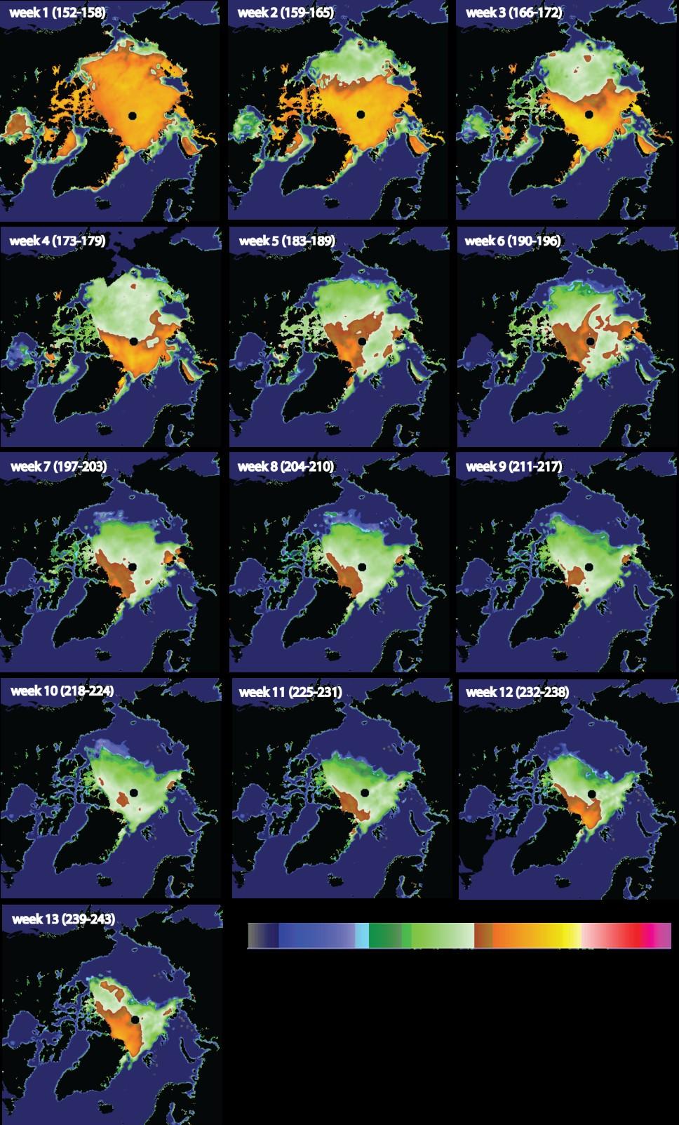
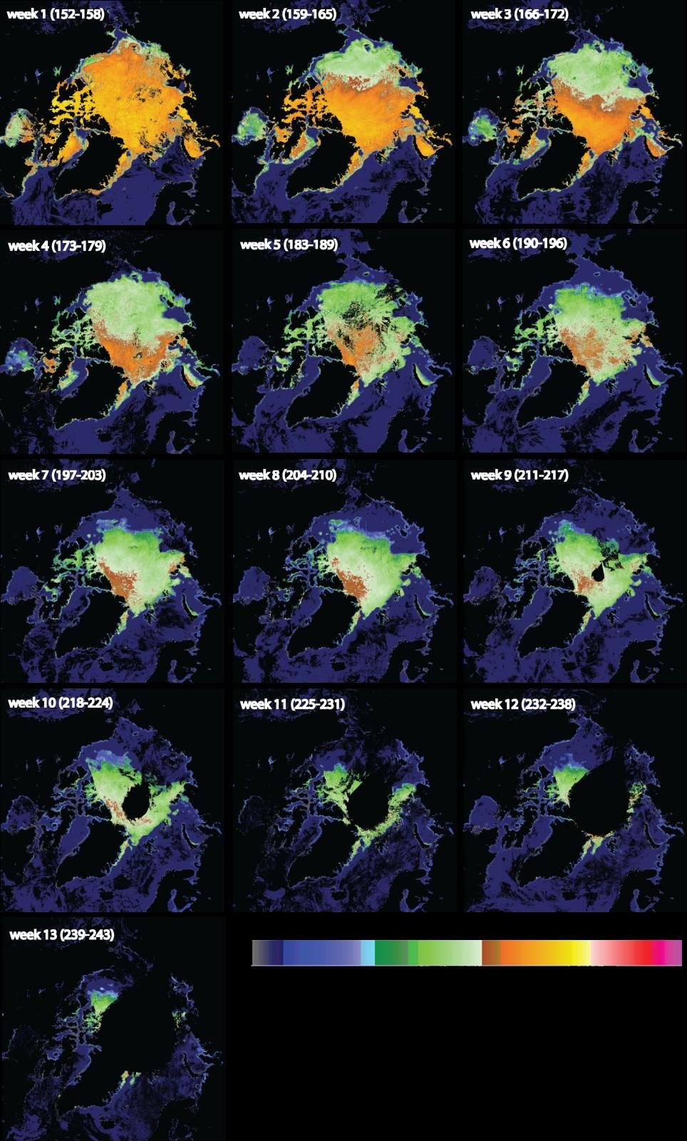
19 Variability in the sea surface albedo in the time series of weekly averages for the summer 2007.

20 Thank you for your attention! pentad SAL
Land surface albedo and downwelling shortwave radiation from MSG: Retrieval, validation and impact assessment in NWP and LSM models
 Land surface albedo and downwelling shortwave radiation from MSG: Retrieval, validation and impact assessment in NWP and LSM models Jean-Louis ROUJEAN, Dominique CARRER, Xavier CEAMANOS, Olivier HAUTECOEUR,
EUMETSAT current activities on desert targets
 EUMETSAT current activities on desert targets Sébastien Wagner sebastien.wagner@eumetsat.int Summary of recent, current and planned activities 1. MSG-3 commissioning 2. Development of monitoring tools
POSSIBILITY OF GCOM-C1 / SGLI FOR CLIMATE CHANGE IMPACTS ANALYZING
 POSSIBILITY OF GCOM-C1 / SGLI FOR CLIMATE CHANGE IMPACTS ANALYZING Y. Honda* a, M. Moriyama b, M. Hori c, M. Murakami c, A. Ono c, K. Kajiwara a a Center for Environmental Remote Sensing (CEReS), Chiba
Landsat 8: Albedo 1. Two methods of computing albedo were used: Liang s and Smith s.
 Landsat 8: Albedo 1 The Alaska scene, which is dominated by snow, had by far the highest average albedo at 0.55. Both Florida and Mississippi scenes had similar average albedo value at around 0.16. The
University of Bristol - Explore Bristol Research
 Tedesco, M., Doherty, S., Warren, S., Tranter, M., Stroeve, J., Fettweis, X., & P, A. (2015). What darkens the Greenland Ice Sheet? Eos, 96. DOI: 10.1029/2015EO035773 Peer reviewed version License (if
Earth energy budget and balance
 Earth energy budget and balance 31% total reflection (3% clouds. 8% surface) 69% absorption( 0% clouds, 49% surface) Reflection is frequency dependent but will be treated as average value for visible light
The EUMETSAT Satellite Application Facility on Land Surface Analysis (LSA SAF) Continuous Development 2 Phase
 Continuous Development 2 Phase") The EUMETSAT Satellite Application Facility on Land Surface Analysis (LSA SAF) Continuous Development 2 Phase Jean-Louis Roujean and many co-authors METEO FRANCE / Toulouse jean-louis.roujean@meteo.fr
The EUMETSAT Satellite Application Facility on Land Surface Analysis (LSA SAF) Continuous Development 2 Phase Jean-Louis Roujean and many co-authors METEO FRANCE / Toulouse jean-louis.roujean@meteo.fr
Level 1b and Level 2 Numbered Validation Requirements
 Sentinel-5 Precursor Level 1b and Level 2 Numbered Validation Requirements Prepared by Thorsten Fehr Reference S5P-RS-ESA-GS-0236 Issue 1 Revision 0 Date of Issue 16/12/2015 Status Final Document Type
Geophysical Validation Needs of the Geostationary Air Quality (GeoAQ) Constellation GEMS + Sentinel-4 + TEMPO Linked together by LEO sensors
 Constellation GEMS + Sentinel-4 + TEMPO Linked together by LEO sensors") Geophysical Validation Needs of the Geostationary Air Quality (GeoAQ) Constellation GEMS + Sentinel-4 + TEMPO Linked together by LEO sensors Ben Veihelmann AC-VC co-chair Sentinel-4 and -5 Mission Scientist,
Geophysical Validation Needs of the Geostationary Air Quality (GeoAQ) Constellation GEMS + Sentinel-4 + TEMPO Linked together by LEO sensors Ben Veihelmann AC-VC co-chair Sentinel-4 and -5 Mission Scientist,
United States Land Cover Land Use Change, Albedo and Radiative Forcing: Past and Potential Climate Implications
 United States Land Cover Land Use Change, Albedo and Radiative Forcing: Past and Potential Climate Implications By Christopher Barnes, PhD Candidate, Geographical Information Science Center of Excellence,
Satellite data products suitable for land surface analysis. Matthias Drusch ESTEC, The Netherlands 10/11/2009
 Satellite data products suitable for land surface analysis Matthias Drusch ESTEC, The Netherlands 10/11/2009 OVERVIEW 1. ESA s SMOS Activities 2. ESA s Snow Activities - Snow Water Equivalent from CoReH2O
Klimaänderung. Robert Sausen Deutsches Zentrum für Luft- und Raumfahrt Institut für Physik der Atmosphäre Oberpfaffenhofen
 Klimaänderung Robert Sausen Deutsches Zentrum für Luft- und Raumfahrt Institut für Physik der Atmosphäre Oberpfaffenhofen Vorlesung WS 2017/18 LMU München 8. Anthropogener und natürlicher Strahlungsantrieb
The Effects of Volcano-Induced Ozone Depletion on Short-Lived Climate Forcing in the Arctic
 C53C-0852 The Effects of Volcano-Induced Ozone Depletion on Short-Lived Climate Forcing in the Arctic Peter L. Ward US Geological Survey Retired Teton Tectonics Jackson, WY 307-733-3664 cell 307-413-4055
CROP STATE MONITORING USING SATELLITE REMOTE SENSING IN ROMANIA
 CROP STATE MONITORING USING SATELLITE REMOTE SENSING IN ROMANIA Dr. Gheorghe Stancalie National Meteorological Administration Bucharest, Romania Content Introduction Earth Observation (EO) data Drought
Study of Water Quality using Satellite data
 2nd Workshop on Parameterization of Lakes in Numerical Weather Prediction and Climate Modelling Study of Water Quality using Satellite data M. Potes, M. J. Costa (Évora Geophysics Centre, PORTUGAL) This
Pollution Climate Interactions during the 20th Century
 Pollution Climate Interactions during the 20th Century Alumni Conference, G&G Department, Yale University November 7, 2009 Koch, D., A spreading drop plume model for Venus. J. Geophys. Res., 1994. Koch,
- geographic patterns of energy balance
 (1 of 10) Further Reading: Chapter 04 of the text book Outline - geographic patterns of energy balance - net radiation - meridional transport (2 of 10) Introduction Previously, we discussed the energy
Satellite observations of fire-induced albedo changes and the associated radiative forcing: A comparison of boreal forest and tropical savanna
 Satellite observations of fire-induced albedo changes and the associated radiative forcing: A comparison of boreal forest and tropical savanna 1 Yufang Jin, 1 James T. Randerson, 2 David P. Roy, 1 Evan
THE IMPACTS OF URBANIZATION ON THE SURFACE ALBEDO IN THE YANGTZE RIVER DELTA IN CHINA
 THE IMPACTS OF URBANIZATION ON THE SURFACE ALBEDO IN THE YANGTZE RIVER DELTA IN CHINA 08/24/2011 Mélanie Bourré Motivation Since the 20th century, rapid urbanization of the world population. United Nation
Relation Between Grain Size and Correlation Length of Snow
 Session C04 Cryosphere: The role of microstructure and layering on the physical properties, metamorphosis, and deformation of snowpacks, AGU Fall Meeting, San Francisco, CA, Dec. 2002 Relation Between
Zu-Tao Ou-Yang Center for Global Change and Earth Observation Michigan State University
 Zu-Tao Ou-Yang Center for Global Change and Earth Observation Michigan State University Ocean Color: Spectral Visible Radiometry Color of the ocean contains latent information on the water qualitycdom,
Land Surface Analysis SAF (LSA SAF)
") Ref. Ares(2014)73020-15/01/2014 Land Surface Analysis SAF (LSA SAF) Pedro Viterbo, Lisboa, Portugal Acknowledgments: Isabel Trigo & the LSA SAF consortium 12-13 December 2011 Lisbon Layout Overview of
Ref. Ares(2014)73020-15/01/2014 Land Surface Analysis SAF (LSA SAF) Pedro Viterbo, Lisboa, Portugal Acknowledgments: Isabel Trigo & the LSA SAF consortium 12-13 December 2011 Lisbon Layout Overview of
EU-FP7 QA4ECV: a 35 year ECV of albedos, fapar & LAI and their uncertainties
 j.muller@ucl.ac.uk EU-FP7 QA4ECV: a 35 year ECV of albedos, fapar & LAI and their uncertainties Folkert Boersma KNMI (Co-ordinator) Jan-Peter Muller UCL (Co-ordinator, Land) Page 1 Version: 24.09.2014
Effects of vertical inhomogeneity on snow spectral albedo and its implication for optical remote sensing of snow
 JOURNAL OF GEOPHYSICAL RESEARCH, VOL. 18, NO. D23, 4738, doi:1.129/23jd3859, 23 Effects of vertical inhomogeneity on snow spectral albedo and its implication for optical remote sensing of snow Xiaobing
Chapter 4: The Global Energy System
 Discovering Physical Geography Third Edition by Alan Arbogast Chapter 4: The Global Energy System The Electromagnetic Spectrum and Solar Energy Solar Energy as Radiation Electromagnetic energy transmitted
Soil Moisture Validation in the U.S.
 Soil Moisture Validation in the U.S. T. J. Jackson, R. Bindlish, I. Mladenova, and M. Cosh USDA ARS Hydrology and Remote Sensing Lab January 16, 2014 Outline Project Overview GCOM-W AMSR2 Brightness Temperature
Role of Remote Sensing in Flood Management
 Role of Remote Sensing in Flood Management Presented by: Victor Veiga (M.Sc Candidate) Supervisors: Dr. Quazi Hassan 1, and Dr. Jianxun He 2 1 Department of Geomatics Engineering, University of Calgary
Copernicus Climate Change Service (C3S)
") Copernicus Service (C3S) European Contribution to the Monitoring of Essential Variables from Space Jean-Noël Thépaut, ECMWF C o p e r n i c u s : E a r t h o b s e r v a t i o n s a n d i n f o r m a t
Copernicus Service (C3S) European Contribution to the Monitoring of Essential Variables from Space Jean-Noël Thépaut, ECMWF C o p e r n i c u s : E a r t h o b s e r v a t i o n s a n d i n f o r m a t
CRYOLAND Copernicus Snow and Land Ice Service. SUMMARY OF ACHIEVEMENTS IN 1st, 2nd, 3rd and 4th PERIOD
 CRYOLAND Copernicus Snow and Land Ice Service SUMMARY OF ACHIEVEMENTS IN 1st, 2nd, 3rd and 4th PERIOD Author: Thomas Nagler / ENVEO, Project Coordinator USER REQUIREMENTS AND USER SUPPORT, PRODUCT AND
Lecture 7 Global Warming/Climate Change (Observations and Attribution of Cause) METR/ENVS 113 Spring Semester 2011 May 3, 2011
 METR/ENVS 113 Spring Semester 2011 May 3, 2011") Lecture 7 Global Warming/Climate Change (Observations and Attribution of Cause) METR/ENVS 113 Spring Semester 2011 May 3, 2011 Reading Henson Rough Guide Chapter 1 Pages 75 127; 215; 227-244 Other pages
Lecture 7 Global Warming/Climate Change (Observations and Attribution of Cause) METR/ENVS 113 Spring Semester 2011 May 3, 2011 Reading Henson Rough Guide Chapter 1 Pages 75 127; 215; 227-244 Other pages
ESA Climate Change Initiative
 ESA Climate Change Initiative Making Transition from Research exercises to operational life cycles for ECV product generation Pascal Lecomte Head of the ESA Climate Office ECSAT Harwell - UK Objectives
THE GREENHOUSE EFFECT AND ITS CONSEQUENCES
 Geography G03 teach with space THE GREENHOUSE EFFECT AND ITS CONSEQUENCES Investigating global warming teacher guide & student worksheets Fast facts page 3 Summary of activities page 4 Introduction page
GLOBAL MAPPING OF TERRESTRIAL VEGETATION PHOTOSYNTHESIS: THE FLUORESCENCE EXPLORER (FLEX) MISSION
 MISSION") Session WE2.09 - International Spaceborne Imaging Spectroscopy Missions: Updates and News II GLOBAL MAPPING OF TERRESTRIAL VEGETATION PHOTOSYNTHESIS: THE FLUORESCENCE EXPLORER (FLEX) MISSION Jose F. Moreno
Session WE2.09 - International Spaceborne Imaging Spectroscopy Missions: Updates and News II GLOBAL MAPPING OF TERRESTRIAL VEGETATION PHOTOSYNTHESIS: THE FLUORESCENCE EXPLORER (FLEX) MISSION Jose F. Moreno
Greenhouse gases. A snow-covered surface refl ects massive amounts of sunlight and therefore has a cooling effect on the climate.
 A k t u e l N a t u r v i d e n s k a b 2 0 0 9 G R E E N H O U S E G A S E S 13 Greenhouse gases - and their impact on the climate The greenhouse effect is the best understood and well mapped of the mechanisms
On the public release of carbon dioxide flux estimates based on the observational data by the Greenhouse gases Observing SATellite IBUKI (GOSAT)
") On the public release of carbon dioxide flux estimates based on the observational data by the Greenhouse gases Observing SATellite IBUKI (GOSAT) National Institute for Environmental Studies (NIES) Ministry
On the public release of carbon dioxide flux estimates based on the observational data by the Greenhouse gases Observing SATellite IBUKI (GOSAT) National Institute for Environmental Studies (NIES) Ministry
Requirements from agriculture applications
 Requirements from agriculture applications Nadine Gobron On behalf Andrea Toreti & MARS colleagues MAIN ACTIVITIES Crop monitoring and yield forecasting in EU and neighbouring countries since 1992 Crop
Climate: Earth s Dynamic Equilibrium
 Climate: Earth s Dynamic Equilibrium review session CCIU April 30, 2016 High-school standard HS-ESS2-4 focuses on the role energy flows play in Earth s climate HS-ESS2-4 Use a model to describe how variations
ESA Climate Change Initiative (CCI) Version 1.0, revision February Author: Will Hewson
 Version 1.0, revision February Author: Will Hewson") Page 1 ESA Climate Change Initiative (CCI) Product User Guide: University of Leicester full physics XCH 4 retrieval algorithm for CRDP3 OCFP v1.0 : Version 1.0, revision 0. Author: Will Hewson Earth Observation
Page 1 ESA Climate Change Initiative (CCI) Product User Guide: University of Leicester full physics XCH 4 retrieval algorithm for CRDP3 OCFP v1.0 : Version 1.0, revision 0. Author: Will Hewson Earth Observation
ATSR Exploitation Board
 MEMO ATSR Exploitation Board From : Hugh Kelliher Reference : AEB.MEM.005 To : cc : AEB Members Date : Issue : Nº Pages : 19 November 2015 11 27 Subject: ATSR Exploitation Board - New Work Items Status
Akiko Suzuki. The Coordination Group for Meteorological Satellites CGMS-45 Plenary 15 June 2017
 The Coordination Group for Meteorological Satellites CGMS-45 Plenary 15 June 2017 Akiko Suzuki Associate Senior Chief Officer of Satellite Applications JAXA Activities Space Transportation Human Space
The Response of the Committee on Earth Observation Satellites (CEOS) to the Global Climate Observing System Implementation Plan 2010 (GCOS IP-10)
 to the Global Climate Observing System Implementation Plan 2010 (GCOS IP-10)") The Response of the Committee on Earth Observation Satellites (CEOS) to the Global Climate Observing System Implementation Plan 2010 (GCOS IP-10) Developed by CEOS and submitted to the United Nations Framework
The Response of the Committee on Earth Observation Satellites (CEOS) to the Global Climate Observing System Implementation Plan 2010 (GCOS IP-10) Developed by CEOS and submitted to the United Nations Framework
How Can Thermal Effects Be Explained?
 How Can Thermal Effects Be Explained? Lesson 6, Part 3: Climate Science The Enhanced Greenhouse Effect The Earth will maintain equilibrium (constant stable temperature level) if the energy coming in is.
AWRA-L and CABLE modelled Tb using CMEM
 AWRA-L and CABLE modelled Tb using CMEM Luigi Renzullo, Ben Gouweleeuw, Albert van Dijk A water information R & D alliance between the Bureau of Meteorology and CSIRO s Water for a Healthy Country Flagship
Global Warming: What is the role of aerosol?
 Global Warming: What is the role of aerosol? Barbara Wyslouzil, Sept. 10 2007 Outline Aerosols 101 The greenhouse effect Global temperature records The global warming problem How do aerosols play a role
The Arctic Energy Budget
 The Arctic Energy Budget The global heat engine [courtesy Kevin Trenberth, NCAR]. Differential solar heating between low and high latitudes gives rise to a circulation of the atmosphere and ocean that
Greenhouse Gas Measurements from Space. Chris O Dell Colorado State University
 Greenhouse Gas Measurements from Space Chris O Dell Colorado State University 1 Climate Forcings & Feedbacks Forcings Greenhouse Gases Aerosols Volcanic Eruptions Solar Forcing Temperature Change Feedbacks
Greenland surface albedo changes in July from satellite observations
 Environmental Research Letters LETTER OPEN ACCESS Greenland surface albedo changes in July 1981 2012 from satellite observations To cite this article: Tao He et al 2013 Environ. Res. Lett. 8 044043 View
Key Issues for EO of Land Surface Processes
 Key Issues for EO of Land Surface Processes Bernard Pinty EC-JRC Institute for Environment and Sustainability, Ispra, Italy Seconded to the Earth Observation Directorate, ESA-ESRIN, Frascati, Italy JRC
WDAC. Geneva, April 10, 2015
 WDAC Geneva, April 10, 2015 Mission WCRP Data Advisory Council (WDAC) act as a single entry point for all WCRP data, information, and observation activities with its sister programmes, coordinate their
Research and Applications using Realtime Direct Broadcast Imagery, Weather Radar, and LiDAR in Disaster Response and Preparedness
 Research and Applications using Realtime Direct Broadcast Imagery, Weather Radar, and LiDAR in Disaster Response and Preparedness Richard P. Watson, Ph.D. University of New Mexico Earth Data Analysis Center
NATS 101 Section 13: Lecture 34. Global Warming Part I
 NATS 101 Section 13: Lecture 34 Global Warming Part I Outline of three part global warming presentation What is the problem? How has the Earth s climate changed in recent years? Are these changes attributable
IPCC WGI AR6 Needs for climate system observation data. Panmao Zhai. Chinese Academy of Meteorological Sciences, China
 IPCC WGI AR6 Needs for climate system observation data Panmao Zhai Chinese Academy of Meteorological Sciences, China 25 September 2017 AR5 WGI Outline 1: Introduction 2: Observations: Atmosphere and Surface
Recent Science on Aerosols in Asia. Yutaka Kondo
 Recent Science on Aerosols in Asia Yutaka Kondo Department of Earth and Planetary Science, Graduate School of Science, University of Tokyo, Tokyo, Japan Translating Co-benefits Resasrch into Action in
Heating and Warming: Sensitivity of Earth s Climate to Atmospheric CO 2
 LIVE INTERACTIVE LEARNING @ YOUR DESKTOP Heating and Warming: Sensitivity of Earth s Climate to Atmospheric CO 2 Presented by: Scott Denning and Randy Russell September 24, 2012 6:30 p.m. 8:00 p.m. Eastern
How do ice and snow help to regulate the overall energy balance on Earth?
 Environmental Literacy Framework Earth s Albedo Focus Questions: How do ice and snow help to regulate the overall energy balance on Earth? What will the impact of climate change be on the Earth s ability
Planetary Energy Balance
 Planetary Energy Balance Overview of Planetary Energy Balance Energy coming into the Earth s atmosphere from the sun is always in balance with the energy leaving Earth s atmosphere going back out into
Sea ice concentration alphabet soup: CDRs, ECVs, ESDRs
 Sea ice concentration alphabet soup: CDRs, ECVs, ESDRs Walt Meier, NASA Goddard Polar Space Task Group Fourth Session 30 September 2014 Formal Definition Climate Data Record (CDR) noun, A time series of
Lecture 11: Global Warming
 Lecture 11: Global Warming CO 2 CH 4 How much of the global warming is caused by Natural climate change and by human activities? What is the sensitivity of Earth s climate to the increases of greehouse
The Chemistry of Climate Change. Reading: Chapter 8 Environmental Chemistry, G. W. vanloon. S. J. Duffy
 The Chemistry of Climate Change Reading: Chapter 8 Environmental Chemistry, G. W. vanloon. S. J. Duffy The Science of Global Climate There's a lot of differing data, but as far as I can gather, over the
Scientific Foundation of Climate Change. Human Responsibility for Climate Change
 Scientific Foundation of Climate Change EOH 468 CSU Northridge Spring 2010 Peter Bellin, CIH, Ph.D. 1 Human Responsibility for Climate Change The IPCC finds that it is very likely that emissions of heat-trapping
Water property monitoring and assessment for China s inland Lake Taihu from
 Water property monitoring and assessment for China s inland Lake Taihu from MODIS-Aqua measurements By Wang M, W Shi and J Tan, Remote Sensing of Environment 115 (2011) 841-854 Wei Wang 9 December 2011
Expert Meeting on Crop Monitoring for Improved Food Security, 17 February 2014, Vientiane, Lao PDR. By: Scientific Context
 Satellite Based Crop Monitoring & Estimation System for Food Security Application in Bangladesh Expert Meeting on Crop Monitoring for Improved Food Security, 17 February 2014, Vientiane, Lao PDR By: Bangladesh
OSCAR/Space Version 2.0 Expert system for instrument assessment and gap analysis
 OSCAR/Space Version 2.0 Expert system for instrument assessment and gap analysis IPET-SUP-2, 23-26 February 2016 Jérôme Lafeuille (Secretariat, WMO Space Programme) WMO/OBS Space Programme Office OSCAR/Space
Greenland Ice Sheet albedo ( ) Insights from a regional climate model and remote sensing data
 Insights from a regional climate model and remote sensing data") Greenland Ice Sheet albedo (2000-2012) Insights from a regional climate model and remote sensing data Patrick Alexander, City College of New York Advisor: Marco Tedesco, CCNY Collaborators: X. FeAweis,
Greenland Ice Sheet albedo (2000-2012) Insights from a regional climate model and remote sensing data Patrick Alexander, City College of New York Advisor: Marco Tedesco, CCNY Collaborators: X. FeAweis,
WDAC. Geneva, March 27, 2015
 WDAC Geneva, March 27, 2015 Mission WCRP Data Advisory Council (WDAC) act as a single entry point for all WCRP data, information, and observation activities with its sister programmes, coordinate their
State of play for a European operational monitoring system for fossil fuel CO 2 emissions
 State of play for a European operational monitoring system for fossil fuel CO 2 emissions Y.J. Meijer, M.R. Drinkwater ESA, Noordwijk, The Netherlands B. Pinty, H. Zunker EC, DG-GROW, Brussels, Belgium
ANALYZING THE SPATIAL AND TEMPORAL VARIABILITY OF WATER TURBIDITY IN THE COASTAL AREAS OF THE UAE USING MODIS SATELLITE DATA
 ANALYZING THE SPATIAL AND TEMPORAL VARIABILITY OF WATER TURBIDITY IN THE COASTAL AREAS OF THE UAE USING MODIS SATELLITE DATA Muna R. Al Kaabi, Jacinto Estima and Hosni Ghedira Ocean Color Group - Earth
Satellite LST User Handbook
 DUE GLOBTEMPERATURE PROJECT Satellite LST User Handbook Organisation: ULeic Page: i Signatures Name Organisation Signature Written by Emma Dodd ULeic Karen Veal ULeic Darren Ghent ULeic Reviewed by Darren
Land Surface Monitoring from the Moon
 Land Surface Monitoring from the Moon Jack Mustard, Brown University Workshop on Science Associated with Lunar Exploration Architecture Unique Perspective of Lunar Observation Platform Low Earth Orbit:
Monitoring of trace-gases, pollution and aerosols with EUMETSAT satellite instruments
 Monitoring of trace-gases, pollution and aerosols with EUMETSAT satellite instruments Ruediger Lang Rosemary Munro, Christian Retscher, Gabriele Poli, Andriy Holdak, Michael Grzegorski, Roger Huckle, Rasmus
Global Warming and the Hydrological Cycle
 Global Warming and the Hydrological Cycle Climate Change Projections Wet regions will become wetter Dry regions will become drier Precipitation will occur less frequently Precipitation will be more intense
The Response of the Committee on Earth Observation Satellites (CEOS) to the Global Climate Observing System Implementation Plan 2010 (GCOS IP-10)
 to the Global Climate Observing System Implementation Plan 2010 (GCOS IP-10)") The Response of the Committee on Earth Observation Satellites (CEOS) to the Global Climate Observing System Implementation Plan 2010 (GCOS IP-10) Developed by CEOS and submitted to the United Nations Framework
The Response of the Committee on Earth Observation Satellites (CEOS) to the Global Climate Observing System Implementation Plan 2010 (GCOS IP-10) Developed by CEOS and submitted to the United Nations Framework
Operational products for crop monitoring. Hervé Kerdiles, JRC MARS
 Operational products for crop monitoring Hervé Kerdiles, JRC MARS Outline Meteo products Rainfall, temperature, global radiation, ETa, snow depth Biomass indicators & crop yield prediction NDVI & other
Albedo. Overview: Objectives: Targeted Alaska Performance Measures Tested on the High School Graduation Qualifying Exam
 albedo Overview: Students learn about albedo and the ice-albedo feedback effect as it relates to snow, ice, and the likely results of reduced snow and ice cover on global temperatures. Objectives: The
Understanding Global Warming
 Math 483 Spring Semester, 2013 California State University, Northridge Understanding Global Warming Global Warming is Real December 2012 is 334th consecutive Month with global temperatures above the 20th
Real time analysis with the Medspiration HR-DDS (High Resolution Diagnostic Data Sets) David J. S. Poulter, National Oceanography Centre, UK
 David J. S. Poulter, National Oceanography Centre, UK") Real time analysis with the Medspiration HR-DDS (High Resolution Diagnostic Data Sets) David J. S. Poulter, National Oceanography Centre, UK Outline 1. Outline 2. Description of the HR-DDS system 3. Time
Real time analysis with the Medspiration HR-DDS (High Resolution Diagnostic Data Sets) David J. S. Poulter, National Oceanography Centre, UK Outline 1. Outline 2. Description of the HR-DDS system 3. Time
Integral Methods of Environmental Assessment at Mining Regions Based on Remote Sensing Data
 Integral Methods of Environmental Assessment at Mining Regions Based on Remote Sensing Data Giniyatullina O.L., Potapov V.P., Schactlivtcev E.L. Institute of Computational Technologies Siberian Branch
Global Greenhouse Gas Observation by Satellite
 Global Greenhouse Gas Observation by Satellite Greenhouse gases Observing SATellite Figure 1. Overview of GOSAT ( JAXA) The Greenhouse Gases Observing Satellite (GOSAT) will be the world s first satellite
Radiative Forcing and
 Radiative Forcing and Feedbacks in Climate Change Júlio C. S. Chagas Entrenamiento en Modelado Numérico de Escenarios de Cambios Climáticos Cachoeira Paulista, 30 de Agosto 4 de Septiembre de 2009. Definitions
Global Atmosphere Watch Activities in Thailand for
 Global Atmosphere Watch Activities in Thailand for WMO GURME Regional Training Workshop on Urban Air Quality Modeling for ASEAN countries Petaling Jaya, Selangor 6-11 April, 2015 Nichanun Trachow Ozone
APPLICATIONS USING THE ATMOSPHERIC DATA OF THE PACE MISSION
 APPLICATIONS USING THE ATMOSPHERIC DATA OF THE PACE MISSION Ali H. Omar (NASA) Maria Tzortziou (CCNY), Woody Turner (NASA) Groups/Subgroups: Atmospheric Correction, Applications, Atmospheric by-products
Impacts of atmospheric aerosols and air pollution in Northern Eurasia and their dynamics
 Impacts of atmospheric aerosols and air pollution in Northern Eurasia and their dynamics Irina N. Sokolik School of Earth and Atmospheric Sciences Georgia Institute of Technology Atlanta, GA, USA Why Northern
SOIL MOISTURE RETRIEVAL FROM OPTICAL AND THERMAL SPACEBORNE REMOTE SENSING
 Comm. Appl. Biol. Sci, Ghent University, 70/2, 2005 1 SOIL MOISTURE RETRIEVAL FROM OPTICAL AND THERMAL SPACEBORNE REMOTE SENSING W.W. VERSTRAETEN 1,2 ; F. VEROUSTRAETE 2 ; J. FEYEN 1 1 Laboratory of Soil
Using MODIS Medium-Resolution Remote Sensing Data to Monitor Hydroclimatic Variability
 Using MODIS Medium-Resolution Remote Sensing Data to Monitor Hydroclimatic Variability Past and Future Hydroclimatic Variability: Applications to water Resources Management in the Prairie Provinces, Canmore,
Radiative forcing of climate change
 Radiative forcing of climate change Joanna D. Haigh Imperial College of Science, Technology and Medicine, London Radiative forcing concept, definition and applications On a global and annual average, and
Air Quality Applications of Satellite Remote Sensing
 Air Quality Applications of Satellite Remote Sensing Randall Martin, Dalhousie and Harvard-Smithsonian Aaron van Donkelaar, Akhila Padmanabhan, Dalhousie University Lok Lamsal, Dalhousie U NASA Goddard
Submission from the Committee on Earth Observation Satellites
 16 October 2012 English only UNITED NATIONS FRAMEWORK CONVENTION ON CLIMATE CHANGE Subsidiary Body for Scientific and Technological Advice Thirty-seventh session Doha, 26 November to 1 December 2012 Item
Improvements of CO 2 and O 2 transmission modeling with application to the ASCENDS mission
 Improvements of CO 2 and O 2 transmission modeling with application to the ASCENDS mission Denis Pliutau and Narasimha S. Prasad NASA Langley Research Center, 5 N. Dryden St., MS 468, Hampton, VA 23681
Light absorption by pollution, dust, and biomass burning aerosols: A global model study and evaluation with AERONET measurements
 Light absorption by pollution, dust, and biomass burning aerosols: A global model study and evaluation with AERONET measurements Mian Chin 1 ( ), Thomas Diehl 1, Oleg Dubovik 2, Tom Eck 1, Brent Holben
Global Climate Observing System
 Global Climate Observing System Dr. William Westermeyer GCOS Secretariat The GCOS Mission To ensure that the data required to meet the needs of users for climate information is obtained and made available
The Power of the Albedo Effect on Global Warming By Leigh Hutchens July 30, 2013 Climate Change
 Absorption and Re-Radiation Lab Name: _ E.N. Read the Power of the Albedo Effect on Global Warming article and define the following items below: http://www.greenoptimistic.com/2013/07/30/the-power-of-the-albedo-effect-on-global-warming/#.ux3jlf5dhr4
Arctic Climate Connections Activity 3 Exploring Arctic Climate Data
 Name Class Arctic Climate Connections Activity 3 Exploring Arctic Climate Data Part A. Understanding Albedo Note that albedo can be expressed either as a ratio or as a percentage. While reading about albedo,
European Forest Fire Information System (EFFIS) - Rapid Damage Assessment: Appraisal of burnt area maps with MODIS data
 - Rapid Damage Assessment: Appraisal of burnt area maps with MODIS data") European Forest Fire Information System (EFFIS) - Rapid Damage Assessment: Appraisal of burnt area maps with MODIS data Paulo Barbosa European Commission, Joint Research Centre, Institute for Environment
European Forest Fire Information System (EFFIS) - Rapid Damage Assessment: Appraisal of burnt area maps with MODIS data Paulo Barbosa European Commission, Joint Research Centre, Institute for Environment
SP-1279 (2) REPORTS FOR MISSION SELECTION THE SIX CANDIDATE EARTH EXPLORER MISSIONS. April 2004
 REPORTS FOR MISSION SELECTION THE SIX CANDIDATE EARTH EXPLORER MISSIONS. April 2004") SP-1279 (2) April 2004 EarthCARE - Earth Clouds, Aerosols and Radiation Explorer SPECTRA - Surface Processes and Ecosystem Changes Through Response Analysis WALES - Water Vapour Lidar Experiment in Space
SP-1279 (2) April 2004 EarthCARE - Earth Clouds, Aerosols and Radiation Explorer SPECTRA - Surface Processes and Ecosystem Changes Through Response Analysis WALES - Water Vapour Lidar Experiment in Space
Global Warming and Climate Change
 Global Warming and Climate Change Weather vs. Climate Weather refers to short term conditions (e.g. 24 hrs.) in meteorological conditions such as temperature, pressure and rainfall Climate is average weather
READING QUESTIONS: Global Climate Change GEOL /WI. 2. Fill in the blanks in the following sentences from the textbook (p.
 READING QUESTIONS: Global Climate Change GEOL 131 18/WI NAME DUE: Tuesday, April 24 57pts Climate and Geology (p. 382) 1. List the five spheres included in the climate system. (5 pts) Detecting Climate
CEOS Intercalibration of Ground-Based Spectrometers and Lidars
 Page 1 of 16 and Satellite Validation Report 2: Recommendations for Inter-Calibration of minispectrometer networks Prepared by Alexander Cede & Martin Tiefengraber, LuftBlick Checked by Christian Retscher,
SILVA FENNICA. Measuring the Vertical Albedo Profile of a Subarctic Boreal Forest Canopy. 1 Background. Aku Riihelä and Terhikki Manninen
 SILVA FENNICA Silva Fennica 42(5) research notes www.metla.fi/silvafennica ISSN 0037-5330 The Finnish Society of Forest Science The Finnish Forest Research Institute Measuring the Vertical Albedo Profile
Supplementary Information
 Supplementary Information How shorter black carbon lifetime alters its climate effect Ø. Hodnebrog 1, *, G. Myhre 1, B. H. Samset 1 1 Center for International Climate and Environmental Research-Oslo (CICERO),