Mark WILLIAMS, Ira ARTZ, Krey PRICE
|
|
|
- Isabella Watkins
- 5 years ago
- Views:
Transcription

1 Restoring Ecosystem Habitat in the Arid Southwestern United States: Lessons Learned Mark WILLIAMS, Ira ARTZ, Krey PRICE Tetra Tech, Inc. United States
2 Ecosystem Restoration in the United States Since 1986, the agency most responsible for providing large-scale, ecosystem restoration projects in the US has been the US Army Corps of Engineers Civil works projects for restoration often $100 s of millions of dollars, with the Everglades costing into the $billions. Tetra Tech has been fortunate to provide support for many restoration projects, especially in the arid Southwestern U.S.

3 Problems in the Arid Southwest Dryland Rivers Hyper-arid environment Southwestern U.S. annual precipitation < cm Evapotranspiration > 100 cm NRCS


4 Problems in the Arid Southwest Even though riparian areas represent <1% of the region s area, they support > 50% of the nesting bird species and >75% of vertebrate wildlife species (Johnson et al., 1977, and Gillis, 1991).

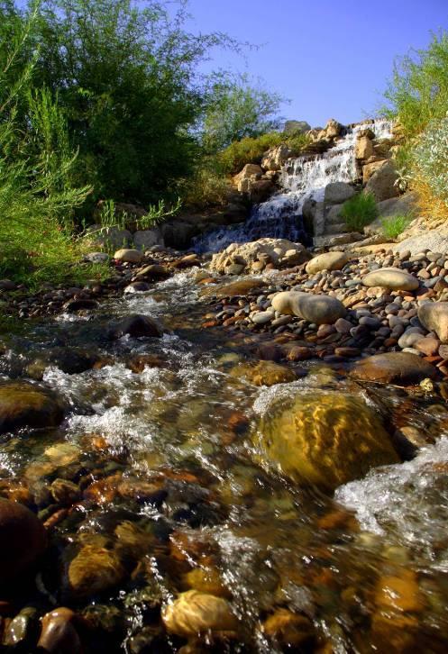
5 Problems in the Arid Southwest Ecosystems like this used to be much more common Prior to dam construction and groundwater overdraft, many streams were perennial The meandering channels included sandbars and backwaters.


6 Problems in the Arid Southwest Cottonwoods, willows, mesquite forests, and cienegas used to fill the floodplain.


7 Problems in the Arid Southwest Degradation caused by upstream dams, drought, climate change, and urban impacts such as groundwater overdraft, floodplain encroachment, habitat loss, modified hydrology, landfills, mining, invasive species, bank stabilization and channelisation USGS Arizona stream: 1904 and recent

8 Problems in the Arid Southwest Lack of vegetation leads to unstable banks, as shown here in 1978 flood event on the Rillito River 70 m of lateral channel migration USGS


9 Problems in the Arid Southwest USGS The southwest has become increasingly urbanised Restoration of riparian ecosystems in the Sonoran Desert considered critical by the Nature Conservancy

10 Opportunities for Restoration The Corps of Engineers and local municipalities have cost-shared several ecosystem restoration studies in the Phoenix and Tucson areas, in Arizona USGS
11 New Mexico Phoenix Gila River Watershed Tres Rios Opportunities for Restoration Verde River Watershed Utah Flagstaff Rio Salado ARIZONA Salt River Watershed Tucson Tetra Tech s role has been to provide planning, economic and environmental analysis, and design support to 3 major projects in the 34,000 square kilometer Salt River watershed, in the Phoenix metropolitan area, Arizona Va Shly ay Akimel
12 New Mexico Opportunities for Restoration Project benefits include the following categories: Habitat creation and restoration Removal of invasives Restoration of gravel pits Restabilisation of the geomorphic regime Water supply through infiltration Flood risk management Recreation

13 New Mexico Restoration Objectives Restoration of a more natural riverine environment: Return ecosystem functions Return species diversity Replace lost riparian habitat Scrub-Shrub Mesquite Mesquite Cottonwood Bosque Wetland Willow Ponded Flow Wetland Cottonwood Willow
14 Avg Annual Costs ($1,000) New Mexico Lesson Learned The challenge in developing a restoration plan is finding the most cost efficient yet effective solution Federal water resource guidelines are strict on economic benefit/cost analyses Relies on comparing a multitude of possible measures Combined into alternatives Rio Salado Oeste Without Project Equivalent Annual Damages (in $1,000s) Reach Structure & Content Cleanup Temp. Housing Total 2L $ 42 $ 10 $ 0.4 $ 52 3L $ 2 $ 1 $ 0.1 $ 3 4L $ 2 $ - $ 0.1 $ 2 5L $ 27 $ 4 $ 0.9 $ 32 6L $ 11 $ 3 $ 0.1 $ 14 Total - S. of River $ 84 $ 18 $ 1.6 $ 104 $16,000 $14,000 $12,000 $10,000 $8,000 $6,000 Rio Salado Oeste Incremental Analysis Alt 4 Alt 5 Alt 5B Alt 5A 5R $ 123 $ 5 $ - $ 128 6R $ 4 $ 0.5 $ - $ 5 Total - N. of River $ 127 $ 6 $ - $ 133 Total $ 211 $ 24 $ 2 $ 236 Notes: Damages for Reaches Not Shown are Minimal $4,000 $2,000 $0 Alt AAFCU's

15 New Mexico Cost Effectiveness Analysis Use of IWR-Plan Incremental analysis program Analyzes thousands of possible combinations of potential features Cost inputs compared to habitat units outputs Results in best-buy and optimised plans Used nationwide


16 Monetary Costs Cost Effectiveness Analysis 20,000 18,000 NOT Cost Effective 16,000 14, B 5A 12,000 10,000 Refine 2 8, , , , Benefits: Habitat Units Best Buy
17 New Mexico Tres Rios Project Located where three rivers meet ( Tres Rios ): the Salt, the Gila, and the Agua Fria The project began as a means of treating treatment plant effluent using constructed wetlands The Plan Formulation analysis justified a 10-km, $110 million restoration project


")
18 Tres Rios IN CONSTRUCTION. SPONSORS: City of Phoenix/Gila River Indian Community $110 M 11 river kilometers Restoration (600 ha) Levee (100-year) Recreation/education Cultural mitigation


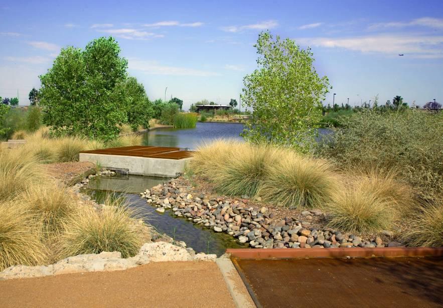
19 91 st Avenue Flood Control Levee Tres Rios Project Plan Overview Overbank Wetlands N Open Water Marshes Riparian Corridors Flow Regulating Wetlands (see next slide)


20 Flow Regulating / Constructed Wetlands
 FRW 1 FRW 1 DW A FRW 2 DW B FRW 3 Effluent Channel Force Mains FRW Inlet Structure Discharge Structure Salt River")
21 New Mexico Flow Regulating / Constructed Wetlands Wetlands even out diurnal treatment plant peaks for more uniform treatment in constructed wetlands Outflow then piped along top of bank with flow outlets into the overbank wetlands USACE Stormwater Channel Overbank Wetlands (OBW) FRW 1 FRW 1 DW A FRW 2 DW B FRW 3 Effluent Channel Force Mains FRW Inlet Structure Discharge Structure Salt River Emergent Zone/Hummocks Open (Deep) Water Road/Maintenance Access Island


22 Riparian Corridors


23 Open Water Marsh
24 Overbank Wetlands OVB - NORTH OBW CULVERTS DISCHARGE SPILLWAY OVB-NORTH USACE PIPE INLET DISCHARGE SPILLWAY OVB-SOUTH USACE - LEVEE SALT RIVER OVB - SOUTH Total Length = 2743 m Total Area = 52 ha Aquatic = 4.5 ha Riparian = 6.8 ha Dimensions Floodplain Terrace = 5.8 ha EFFLUENT CHANNEL Wetland = 32.6 ha Mesquite = 2.3 ha SALT RIVER AUXILLARY DISCHARGE

25 New Levee Alignment


26 Va Shly ay Akimel Historic Condition: Perennial water High water table Braided & meandering Cottonwood/willow, mesquite communities Braided and meandering

27 Va Shly ay Akimel Current condition: Incised, isolated low-flow channels Erosion during higher flows Gravel pits have drained groundwater and degraded habitat
28 Authorized Project Habitat enhancement Terracing / channel re-shaping Grade control structures Bank stabilization Open water / wetlands Cultural and ecological education centers Recreation
29 Authorized Project


30 Restores: Authorized Project 360 hectares cottonwood/willow 150 hectares mesquite 80 hectares wetlands 10 hectares Sonoran desert scrub shrub approximately 8 km of maintained trails $140 M 22 river km
31 Rio Salado Project First ecosystem restoration project for which the Army Corps of Engineers received authorization Challenges included scrutiny by higher authority on high cost of habitat units relative to projects in more hydric communities in the eastern United States Use of potentially-contaminated groundwater for initial irrigation also resulted in scrutiny

32 Rio Salado Project Additional constraints: Regulated Hydrology upstream dams dampen the natural peak flow conditions Poor groundwater quality Need to maintain flood conveyance capacity Source and cost of water Birdstrikes to aircraft a threat Ongoing gravel mining operations


33 Lessons Learned (continued) The challenge in restoration projects is to find creative and defensible solutions Authorization granted by higher Corps authority Groundwater treatment allowed determined to be least cost source of supply Wetland locations for bird refuges moved Agreements reached with mining operators


34 Cost = $100M Length = 10 kilometers 275 hectares restored Restoration Success Demonstration project shown


35 Rio Salado Project


36


37 Primary Lesson Learned Partnerships are Critical for Success Flood Control District of Maricopa County US Army Corps of Engineers Gila River Indian Community Salt River Pima- Maricopa Indian Community
38 Questions? Tetra Tech would like to acknowledge and thank the US Army Corps of Engineers, Phoenix office, for making past graphics available
A Look at Ecosystem Restoration in Arizona
 A Look at Ecosystem Restoration in Arizona Water Resources Research Center 2005 Water Conference Water and the Environment: The Role of Ecosystem Restoration April 6, 2005 Sharon B. Megdal, Director Water
City of Phoenix Tres Rios Wetlands: Water Sustainability & Efficiency. Cynthia Campbell Water Resource Management Advisor City of Phoenix
 City of Phoenix Tres Rios Wetlands: Water Sustainability & Efficiency Cynthia Campbell Water Resource Management Advisor City of Phoenix Phoenix is a Desert City Phoenix Water Supplies 50% Salt/Verde Rivers
Projects to Enhance Arizona s Environment: An Examination of their Functions, Water Requirements and Public Benefits
 Projects to Enhance Arizona s Environment: An Examination of their Functions, Water Requirements and Public Benefits Arizona Riparian Council Annual Meeting Flagstaff Arizona April 27-29, 2006 Sharon B.
AWPF Program Overview Rodney Held, Executive Director
 AWPF Program Overview Rodney Held, Executive Director A Community on Ecosystem Services Conference Major Domestic & International Ecosystem Restoration Initiatives Session December 6, 2010 AWPF Purpose
Approaches to Address Riparian Issues in Arizona The 1980s, 1990s, and the New Century
 Approaches to Address Riparian Issues in Arizona The 1980s, 1990s, and the New Century W. E. Werner Environmental Program Manager Arizona Department of Water Resources 1980s Increasing interest in riparian
Wetland restoration and monitoring on the Chevelon Wildlife Area
 Wetland restoration and monitoring on the Chevelon Wildlife Area Michael Ingraldi, Ph.D. Research Branch Arizona Game and Fish Department Phoenix, Arizona 85023 The Chevelon State Wildlife Area is located
1. Use Conceptual Ecosystem Models. Leigh Skaggs, Office of Water Project Review
 Recent Experiences with Cost Effectiveness and Incremental Cost Analyses (CE/ICA) for Ecosystem Restoration Projects Leigh Skaggs, Office of Water Project Review Recent reviews of Civil Works ecosystem
4. Present Activities and Roles
 4. Present Activities and Roles The present missions, authorities, activities and roles of the various agencies involved with flood protection, floodplain management and flood-damage reduction are identified
Understanding Arizona s Riparian Areas
 Understanding Arizona s Riparian Areas Editor: George Zaimes Funding provided for the workshops and this publications by Renewable Resources Extension Act Grant. Photos from cover page (photos on left
5.15 Wetlands and Other Waters of the U.S.
 I-70 East Final EIS 5.15 Wetlands and Other Waters of the U.S. 5.15 Wetlands and Other Waters of the U.S. This section discusses wetlands, open waters, and other waters of the U.S. in the study area and
Hydrologic Regime; Past and Present and Water Quality Implications
 Hydrologic Regime; Past and Present and Water Quality Implications Waseca County Water Plan Meeting Waseca County Courthouse Annex November 16, 2016 Dan Girolamo, Area Hydrologist, Waterville, MN Topics
Wood-Pawcatuck Watershed Flood Resiliency Management Plan
 Wood-Pawcatuck Watershed Flood Resiliency Management Plan Project Steering Committee Kickoff Meeting March 26, 2015 Wood-Pawcatuck Watershed Association Meeting Agenda 10:00 10:05 Welcome and Opening Remarks
Support legislation that will protect the quantity of water in Lake Erie
 Specific Regional Priorities Each of Pennsylvania s major drainage basins has an array of individual characteristics that distinguish it from other regions of the state. These include diverse geographic
Water Quality Stewardship Plan (WaQSP)
") Salt Lake Countywide Water Quality Stewardship Plan (WaQSP) Natalie Rees Salt Lake County Flood Control & Engineering Division 2008 Watershed Symposium COUNTY RESPONSIBILITY AND AUTHORITY Salt Lake County
Salt Lake Countywide Water Quality Stewardship Plan (WaQSP) Natalie Rees Salt Lake County Flood Control & Engineering Division 2008 Watershed Symposium COUNTY RESPONSIBILITY AND AUTHORITY Salt Lake County
Surface Water. Solutions for a better world
 1 Surface Water Solutions for a better world Our Surface Water Services Expertise Growing worldwide awareness of water scarcity has encouraged water preservation programs, better irrigation techniques
Planning Board Meeting. Proposed Central New York Wetland Mitigation Bank
 Planning Board Meeting Proposed Central New York Wetland Mitigation Bank May 31, 2017 CNYRPDB Mitigation Interests Why consider stream and wetland mitigation Planning Economic Development in concert with
Wetland Resources Cultural, Historical and Environmental Significance
 Wetland Resources Cultural, Historical and Environmental Significance Maryann McGraw Wetlands Program Coordinator New Mexico Environment Department Wetlands Program What is a wetland? (What is a mountain?
S.R. 4007, Section 14B PADEP Environmental Assessment Form. Enclosure C Description of Aquatic Habitat
 S.R. 4007, Section 14B PADEP Environmental Assessment Form Description of Aquatic Habitat Cresheim Creek is the only water resource that exists within the project area. No jurisdictional wetlands were
Wood Canyon Emergent Wetland Project. City of Aliso Viejo 12 Journey, Suite 100 Aliso Viejo, CA 92656
 Wood Canyon Emergent Wetland Project City of Aliso Viejo 12 Journey, Suite 100 Aliso Viejo, CA 92656 Introduction Wood Canyon is located within Aliso and Wood Canyon Regional Park in southwest Orange County,
TABLE OF CONTENTS. TOC-i
 TOC-i TABLE OF CONTENTS 1.0 INTRODUCTION... 1-1 Riparian Corridor Study and Management Plan Goals... 1-1 Study Area... 1-2 Importance and Functions of Riparian Corridors... 1-2 Habitat for Mammals, Birds,
5. RESOURCE MANAGEMENT STRATEGIES
 Central Orange County Integrated Regional Water Management Plan 5. RESOURCE MANAGEMENT STRATEGIES 5.1 STRATEGIES INAPPLICABLE TO REGION Nearly all types of resource management strategies are applicable
Appendix P. U.S. Fish and Wildlife Service Planning Aid Letter
 Appendix P U.S. Fish and Wildlife Service Planning Aid Letter This page is intentionally left blank. United States Department of the Interior FISH AND WILDLIFE SERVICE Missouri Ecological Services Field
Ten Principles of River Restoration and Four River Project of Korea
 Ten Principles of River Restoration and Four River Project of Korea Randolph T. Hester, G. Mathias Kondolf, Marcia McNally, Department of Landscape Architecture and Environmental Planning University of
There is a reliable, clean water supply for current and future generations.
 E2 There is a reliable, clean water supply for current and future generations. E2.1. Current and future water supply for municipalities, industries, agriculture, and the environment is reliable. 2.1.1.
Water and Watersheds. Data Maps Action
 Water and Watersheds Data Maps Action What is the Wildlife Action Plan? Restore rare wildlife and habitats. Keep common species common. 2015 Revision: Partners in Conservation Science 2015 Revision Data
Sacramento River General Reevaluation Report
 Sacramento River General Reevaluation Report Yolo Bypass Working Group 24 May 2016 US Army Corps of Engineers Guidance Engineer Circular (EC) 1105-2-404 Planning Civil Works Projects under the Environmental
Using Section 729 Watershed Assessments for Ecosystem Restoration in the Ohio River Basin
 Using Section 729 Watershed Assessments for Ecosystem Restoration in the Ohio River Basin 2011 National Conference on Ecosystem Restoration R. Gus Drum RLA Senior Lead Planner, Huntington District US Army
RIPARIAN CORRIDOR STUDY FINAL PARLEYS CREEK MANAGEMENT PLAN TABLE OF CONTENTS
 TABLE OF CONTENTS 1.0 INTRODUCTION... 1-1 Riparian Corridor Study and Management Plan Goals... 1-1 Study Area... 1-2 Importance and Functions of Riparian Corridors... 1-2 Habitat for Mammals, Birds, and
Geomorphologic Condition and Shallow Aquifers
 Geomorphologic Condition and Shallow Aquifers Shann Stringer Center for Ecological Sciences Geomorphology Fluvial geomorphology is the study of the physics of water, sediment, riparian area, and floodplain
U.S. ARMY CORPS OF ENGINEERS BUILDING STRONG LOS ANGELES DISTRICT
 PUBLIC NOTICE U.S. ARMY CORPS OF ENGINEERS BUILDING STRONG LOS ANGELES DISTRICT APPLICATION FOR PERMIT (EXTENSION OF COMMENT PERIOD) PRM Gravel Pit Reclamation Public Notice/Application No.: SPL-2007-01460-MWL
What is an ecosystem?
 What is an ecosystem? An ecosystem is generally defined as a community of organisms living in a particular environment and the physical elements in that environment with which they interact. (http://www.enviroliteracy.org/category.php/3.html)
Central Arizona Land Trust Protecting Family Agricultural Lands in the Verde Valley
 Central Arizona Land Trust Protecting Family Agricultural Lands in the Verde Valley Fauna, Farms and Flows Dan Campbell Director, TNC Verde Program Verde River one of the last living rivers left in the
Jordan River Basin. Planning for the Future. Salt Lake County Watershed Symposium (August 11, 2011) Todd Stonely Utah Division of Water Resources
 Todd Stonely Utah Division of Water Resources") Jordan River Basin Planning for the Future Todd Stonely Utah Division of Water Resources Salt Lake County Watershed Symposium (August 11, 2011) 8/12/2011 Jordan River Basin Planning for the Future Slide
Jordan River Basin Planning for the Future Todd Stonely Utah Division of Water Resources Salt Lake County Watershed Symposium (August 11, 2011) 8/12/2011 Jordan River Basin Planning for the Future Slide
Constructing Wetlands for Wastewater Treatment: Design Considerations & Strategies for Success
 Constructing Wetlands for Wastewater Treatment: Design Considerations & Strategies for Success Metropolitan Water Reclamation District of Greater Chicago and V3 Companies Introductions Jennifer Maercklein,
Wood-Pawcatuck Watershed Flood Resiliency Management Plan
 Wood-Pawcatuck Watershed Flood Resiliency Management Plan Project Steering Committee Meeting May 21, 2015 Wood-Pawcatuck Watershed Association Meeting Agenda 10:00 10:05 Welcome and Opening Remarks 10:05
DEPARTMENT OF THE ARMY CHIEF OF ENGINEERS 2600 ARMY PENTAGON WASHINGTON, D.C
 DEPARTMENT OF THE ARMY CHIEF OF ENGINEERS 2600 ARMY PENTAGON WASHINGTON, D.C. 20310-2600 DAEN DEC 1 8 2015 THE SECRETARY OF THE ARMY I. I submit for transmission to Congress my report on ecosystem restoration
Logan River at Rendezvous Park, Channel and Floodplain Restoration: Crack Willow (Salix fragilis) Issues and Management Strategies
 Issues and Management Strategies") Logan River at Rendezvous Park, Channel and Floodplain Restoration: Crack Willow (Salix fragilis) Issues and Management Strategies Prepared May 2, 2017 by Darren Olsen, BIO-WEST, Inc. Issues Crack willow
Logan River at Rendezvous Park, Channel and Floodplain Restoration: Crack Willow (Salix fragilis) Issues and Management Strategies Prepared May 2, 2017 by Darren Olsen, BIO-WEST, Inc. Issues Crack willow
Mukwonago River Watershed Protection Plan Recommendations & Implementation Update Friends of Mukwonago River March 16, 2013 Mukwonago, WI
 Mukwonago River Watershed Protection Plan Recommendations & Implementation Update Friends of Mukwonago River March 16, 2013 Mukwonago, WI Thomas M. Slawski, Principal Specialist Biologist Southeastern
RIPARIAN CORRIDOR STUDY FINAL CITY CREEK MANAGEMENT PLAN TABLE OF CONTENTS
 TABLE OF CONTENTS 1.0 INTRODUCTION... 1-1 Riparian Corridor Study and Management Plan Goals... 1-1 Study Area... 1-2 Importance and Functions of Riparian Corridors... 1-2 Habitat for Mammals, Birds, and
Environmental Flows in Elephant Butte Irrigation District. Gary Esslinger Manager, EBID
 Environmental Flows in Elephant Butte Irrigation District Gary Esslinger Manager, EBID E Flow in E BID Riparian Restoration Goal: To supply surface water to historic floodplain for purposes of growing
INDIAN CREEK WATERSHED PLAN EXECUTIVE SUMMARY
 INDIAN CREEK WATERSHED PLAN EXECUTIVE SUMMARY The Indian Creek Watershed covers a 38 square mile area in southern Lake County, Illinois that drains 24,116 acres before discharging into the Des Plaines
Town of Aurora Stream Management Master Plan PUBLIC INFORMATION CENTRE May 1 st, 2018
 Town of Aurora Stream Management Master Plan PUBLIC INFORMATION CENTRE May 1 st, 2018 Your comments are encouraged and appreciated, as this will provide us an opportunity to address project issues and
Wastewater Reuse - How Viable is It? Another Look
 Wastewater Reuse - How Viable is It? Another Look Item Type text; Proceedings Authors Chase, W. L.; Fulton, J. Publisher Arizona-Nevada Academy of Science Journal Hydrology and Water Resources in Arizona
Drainage Criteria Manual Review
 City of Colorado Springs Stormwater Management Assessment and Standards Development Drainage Criteria Manual Review March 8, 2013 Springsgov.com/City Agencies/Stormwater/Stormwater Engineering/ Stormwater
Multi-Benefit Planning in the San Joaquin River Basin-wide Feasibility Study
 Multi-Benefit Planning in the San Joaquin River Basin-wide Feasibility Study September 8 th, 2016 Presented by: Eric Tsai, P.E. California Department of Water Resources Eric.Tsai@water.ca.gov Jeremy Thomas,
ENVIRONMENTAL ASPECTS OF INTEGRATED FLOOD MANAGEMENT
 ENVIRONMENTAL ASPECTS OF INTEGRATED FLOOD MANAGEMENT Photo by: Liang Changsheng WMO WMO/GWP ASSOCIATED PROGRAMME ON FLOOD MANAGEMENT (APFM) World Meteorological Organization 1 Flood Plains Positive aspects:
Introduction and Background
 Securing Sustainable Water Supplies in Arizona Sharon B. Megdal, Ph.D. 1 The University of Arizona Water Resources Research Center IDS-Water 2004 Conference, May 2004 Introduction and Background Arizona
MAJOR THEMES IN ARIZONA S WATER FUTURE
 Chapter 2 MAJOR THEMES IN ARIZONA S WATER FUTURE KATHY JACOBS AND MARSHALL A. WORDEN Seven major themes or overarching concerns regarding Arizona s water future are discussed in succeeding chapters. Information
Development of the Wetland Program at the Salt River Pima-Maricopa Indian Community
 Development of the Wetland Program at the Salt River Pima-Maricopa Indian Community Presented by Thomas Krebs Water Quality Program CDD-EPNR The SRPMIC Wetland Location Program The SRPMIC Wetland Land
Pennsylvania Stormwater Best Management Practices Manual. Chapter 3. Stormwater Management Principles and Recommended Control Guidelines
 Pennsylvania Stormwater Best Management Practices Manual Chapter 3 Stormwater Management Principles and Recommended Control Guidelines 363-0300-002 / December 30, 2006 Chapter 3 Stormwater Management Principles
VEGETATIVE, WATER, FISH AND WILDLIFE RESOURCES POLICIES
 VEGETATIVE, WATER, FISH AND WILDLIFE RESOURCES POLICIES The County will: GOALS AND OBJECTIVES 1.1 Conserve, Enhance, Protect, Maintain and Manage Vegetative, Water, Fish and Wildlife Resources Promote
Plan Formulation Strategies for Ecosystem Restoration Projects
 Plan Formulation Strategies for Ecosystem Restoration Projects Leigh Skaggs Office of Water Project Review PCoP Webinar 1 September 2016 US Army Corps of Engineers A quick recap from our April PCoP webinar
PRESENTERS. Contact Information: RW Armstrong Union Station, 300 S. Meridian St. Indianapolis, IN
 1 PRESENTERS David Bourff, Director of Environmental Planning Simon Davies, LEED AP, Environmental Scientist Summer O Brien, PWS, Senior Environmental Scientist Contact Information: RW Armstrong Union
Habitat Grant Projects Clinton River Watershed
 Habitat Grant Projects Clinton River Watershed L Y N N E S E Y M O U R E N V I R O N M E N T A L E N G I N E E R O F F I C E O F T H E M A C O M B C O U N T Y P U B L I C W O R K S C O M M I S S I O N
Snitz Creek Park Wetland Mitigation Bank Prospectus. Pennsylvania Department of Transportation Engineering District 8-0
 Snitz Creek Park Wetland Mitigation Bank Prospectus Pennsylvania Department of Transportation Engineering District 8-0 February 2010 In accordance with 33 CFR 332.8(d)(2), The Pennsylvania Department of
SHORELINE INVENTORY AND RESTORATION PLANNING
 CHAPTER 3 SHORELINE INVENTORY AND RESTORATION PLANNING A. PURPOSE OF THE SHORELINE INVENTORY AND CHARACTERIZATION A first step in the comprehensive Master Program update process is development of a shoreline
Bluff Creek One Water
 Bluff Creek One Water The Bluff Creek Watershed has no lakes within its boundaries. As the westernmost watershed within the District, land use changes from agricultural to residential have occurred relatively
Watershed Hydrology: Go with the flow. Greg Jennings, PhD, PE
 Watershed Hydrology: Go with the flow Greg Jennings, PhD, PE jenningsenv@gmail.com Streams What are your CHALLENGES? Hydrology too much water Pollutants upstream and on-site Vegetation wrong plants, wrong
South St. Vrain / Hall Meadows Restoration Planning August 20, 2015
 South St. Vrain / Hall Meadows Restoration Planning August 20, 2015 Agenda Introductions Purpose & Goals of Meeting Planning Area Master Plan Restoration Planning: Cost Estimates, Grants, Scope, Timeline
General Riparian Vegetation Concepts. General Riparian Vegetation Concepts WHY?
 General Riparian Vegetation Concepts General Riparian Vegetation Concepts Riparian vegetation is important because: It Stabilizes streambanks with extensive root systems. Shades the water Improves water
Notice of Intent to Prepare an Environmental Impact Statement for the Denver
 This document is scheduled to be published in the Federal Register on 01/11/2016 and available online at http://federalregister.gov/a/2016-00204, and on FDsys.gov BILLING CODE: 3720-58 DEPARTMENT OF DEFENSE
2013 Water and Watershed Conference Plymouth State University March 22, Chris Skoglund
 New Hampshire s Watersheds at a Crossroads Coordinating a Response to Climate Change, Population Growth and Land-Use Change Using the DPSIR Model 2013 Water and Watershed Conference Plymouth State University
WELCOME. Eastern Subwatersheds Stormwater Management Retrofit Study. Online Information Session #2 June 15 to July 13, 2018
 WELCOME Eastern Subwatersheds Stormwater Management Retrofit Study Online Information Session #2 June 15 to July 13, 2018 1 Eastern Subwatersheds Stormwater Management Retrofit Study This study is one
LIVING LANDS Helping Land Trusts Conserve Biodiversity
 LIVING LANDS Helping Land Trusts Conserve Biodiversity Habitat Restoration: Information for Land Trusts What is Habitat Restoration? Habitat restoration is defined as the process of assisting the recovery
Flood Pulsing in Wetlands: Restoring the Natural Hydrological Balance edited by Beth A. Middleton National Wetlands Research Center, USGS, Lafayette,
 Flood Pulsing in Wetlands: Restoring the Natural Hydrological Balance edited by Beth A. Middleton National Wetlands Research Center, USGS, Lafayette, Louisiana John Wiley & Sons, Inc. Flood Pulsing in
Bylaw , being "Official Community Plan Bylaw, 2016" Schedule "A" 5Improve. Natural + Built Systems
 Bylaw 2600-2016, being "Official Community Plan Bylaw, 2016" Schedule "A" 5Improve Natural + Built Systems Vision Abbotsford will become both more city and more country, where the city becomes more urban
Landscape Performance Benefits & Methods
 Landscape Performance Benefits & Methods Case Study prepared by: Research Fellow: G Mathias Kondolf, Professor and Chair of Landscape Architecture & Environmental Planning, UC Berkeley Research Assistants:
Stormwater Quality & LID for Ephemeral Watersheds. Marie Light April 9th, Low Impact Development Workshop
 Stormwater Quality & LID for Ephemeral Watersheds Marie Light April 9th, 2015 2015 Low Impact Development Workshop 2 Topics Surface Water Quality Standards Ephemeral Aquatic Communities Natural Processes
Balancing Life Safety with Ecological Health and Economic Sustainability: Challenging the Status Quo in the Sacramento River Valley and Delta
 Balancing Life Safety with Ecological Health and Economic Sustainability: Challenging the Status Quo in the Sacramento River Valley and Delta Sara Schultz Water Resources Planner Sacramento District, USACE
CHESAPEAKE BAY COMPREHENSIVE WATER RESOURCES AND RESTORATION PLAN - UPDATE. Update to Chesapeake Bay Program STAR January 25, 2018
 CHESAPEAKE BAY COMPREHENSIVE WATER RESOURCES AND RESTORATION 255 255 255 237 237 237 0 0 0 217 217 217 163 163 163 200 200 200 PLAN - UPDATE 131 132 122 239 65 53 80 119 27 110 135 120 252 174.59 112 92
Public Information Centre September 19 th, 2017
 Public Information Centre September 19 th, 2017 WELCOME! Public Information Centre for the Maple Hill Creek Rehabilitation Class Environmental Assessment Please take the time to sign our sign in sheet
Environmental Check List Georgia Environmental Policy Act
 Environmental Check List Georgia Environmental Policy Act Project No. : Project Name: GEORGIA IS AREA AFFECTED? IF AFFECTED, HOW SEVERELY? AREA/CATEGORY NO YES UNKNOWN MINOR MEDIAN MAJOR UNKNOWN 1. Wetlands
What Are Environmental (Instream) Flows?
 Flows?") 1 What Are Environmental (Instream) Flows? Sustainable water management requires that both human needs and the needs of aquatic and riparian ecosystems be fulfilled. Dams and diversion of water for municipal
1 What Are Environmental (Instream) Flows? Sustainable water management requires that both human needs and the needs of aquatic and riparian ecosystems be fulfilled. Dams and diversion of water for municipal
Managed Aquifer Recharge for the Arizona Desert: The Development of Large Surface Water Spreading Facilities
 ABSTRACT & POWERPOINT PRESENTATION Managed Aquifer Recharge for the Arizona Desert: The Development of Large Surface Water Spreading Facilities Mario R. Lluria, Ph.D., P.G. Senior Professional Geohydrologist
Background. AEM Tier 2 Worksheet Stream & Floodplain Management. Glossary
 AEM Tier 2 Worksheet Stream & Floodplain Management Glossary Bankfull Stage: The stage at which water starts to flow over the flood plain; the elevation of the water surface at bankfull discharge. (This
IMPROVING OUTCOMES FOR STREAM ALTERATION PROJECTS
 IMPROVING OUTCOMES FOR STREAM ALTERATION PROJECTS Bethany Matousek Inland Lakes and Streams Program Coordinator Wetlands, Lakes and Streams Unit DEQ Water Resources Division MatousekB@Michigan.gov 517-243-6421
Sturgeon River Watershed Alliance
 Sturgeon River Watershed Alliance State of the Watershed Overview and Intermunicipal Partnership October 19, 2017 Presented by: Melissa Logan, P.Biol. Environmental Coordinator, Sturgeon River and Natural
A Role for Dispersed Groundwater Recharge Systems to Balance the Effects of Hydromodification
 ABSTRACT & POWERPOINT PRESENTATION A Role for Dispersed Groundwater Recharge Systems to Balance the Effects of Hydromodification Daniel B. Stephens, Ph.D. Principal Hydrologist Daniel B. Stephens & Associates,
Unsteady-Flow Modeling for Emergency Shutdown of the CAP Canal
 Utah State University DigitalCommons@USU International Symposium on Hydraulic Structures Jun 29th, 1:30 PM - 3:30 PM Unsteady-Flow Modeling for Emergency Shutdown of the CAP Canal Bert Clemmens bclemmens@westconsultants.com
Understanding and Restoring Natural Floodplain Function. Gary James CTUIR Fisheries Program Manager
 Understanding and Restoring Natural Floodplain Function Gary James Fisheries Program Manager Future of Our Salmon Technical Workshop on Healthy Floodplains Spokane, WA - August 16-18, 2016 Presentation
Pacheco Reservoir Expansion
 California Water Commission Pacheco Reservoir Expansion Unique Opportunity for Fisheries Recovery, Flood Risk Reduction and Emergency Water Supply December 13, 2017 1 of 33 Project Partners Pacheco Pass
STREAM RESTORATION PURPOSE, PRACTICE, AND METHODS. By Marcus Rubenstein, CPESC
 STREAM RESTORATION PURPOSE, PRACTICE, AND METHODS By Marcus Rubenstein, CPESC WHAT IS STREAM RESTORATION? The return of a stream s lost natural functions, usually resulting from watershed alterations,
Case Study Murray-Darling Basin, Australia Eugene, OR. Valuing a Watershed s Natural Capital
 Case Study Murray-Darling Basin, Australia Eugene, OR Valuing a Watershed s Natural Capital The Academy s June 21, 2012 webinar, with guests Rosalind Bark, Resource Ecological Specialist at Australia s
U.S. ARMY CORPS OF ENGINEERS BUILDING STRONG LOS ANGELES DISTRICT
 PUBLIC NOTICE U.S. ARMY CORPS OF ENGINEERS BUILDING STRONG LOS ANGELES DISTRICT APPLICATION FOR PERMIT SFPP Pipeline Protection (MP 266.4) Public Notice/Application No.: SPL-2013-539-RJD Project: Stabilize
Technical Memorandum Mine Plan of Operations Stormwater Assessment
 Tucson Office 3031 West Ina Road Tucson, AZ 85741 Tel 520.297.7723 Fax 520.297.7724 www.tetratech.com Technical Memorandum Mine Plan of Operations Stormwater Assessment To: Kathy Arnold From: David R.
The Nature Conservancy Cosumnes River Preserve Franklin Boulevard Galt CA 95632
 Study Partners The Nature Conservancy Cosumnes River Preserve 13501 Franklin Boulevard Galt CA 95632 East Bay Municipal Utility District 1 Winemaker Way, Unit K Lodi CA 95240 Sacramento County Water Agency
ARIZONA. Arizona. Smart Solar Focusing on Low-Conflict Zones to Promote Arizona s Economy, Protect Wildlands and Build a Clean Energy Future
 ARIZONA The sun shines almost year round on, and with strong local support for renewable energy and proximity to urban energy markets, it is a great place for solar energy development. With the needed
Community. Restoration. Prevention.
 Community. Restoration. Prevention. Truckee Wetlands Restoration Project Thank you to our Funders Donors to the OUR VALUES PARTNERSHIPS ECOLOGICALLY SOUND ECONOMICS Truckee River Watershed Council May
Maitland Valley WATERSHED
 Maitland Valley WATERSHED Report Card 2018 Maitland Conservation has prepared this report card as a summary of the state of your forests, wetlands, and water resources. WHERE ARE WE? We are one of 36 Conservation
U.S. ARMY CORPS OF ENGINEERS BUILDING STRONG LOS ANGELES DISTRICT
 PUBLIC NOTICE U.S. ARMY CORPS OF ENGINEERS BUILDING STRONG LOS ANGELES DISTRICT APPLICATION FOR PERMIT SFPP Pipeline Protection (MP 267.6) Public Notice/Application No.: SPL-2013-540-RJD Project: Stabilize
FEMA s Mitigation Support for Resiliency: Innovative Drought and Flood Mitigation Projects
 FEMA s Mitigation Support for Resiliency: Innovative Drought and Flood Mitigation Projects Jordan Williams, CFM Eric Kenney, PE, CFM May 4, 2017 2 Hazard Mitigation Purpose: Research climate resilient
Gunnison Basin Wet Meadow and Riparian Restoration and Resilience-Building Project
 Gunnison Basin Wet Meadow and Riparian Restoration and Resilience-Building Project 1. CRITICAL WILDLIFE HABITAT Wet meadows and riparian areas occupy a small proportion of the sagebrush ecosystem in the
Wetland Functions in the Watershed: Part 1 Watershed Elements. USDA NRCS Module Name 1
 Wetland Functions in the Watershed: Part 1 Watershed Elements USDA NRCS Module Name 1 Objectives Define Landscape Elements in the Watershed Describe Hydrologic Connections Between Elements Introduce Soil
City of Valdosta Land Development Regulations
 Chapter 324 Section 324-1 Environmental Planning Criteria Protection of Groundwater Recharge Areas (A) Purpose and Intent. Pursuant to O.C.G.A. 12-2-8 and the Georgia Department of Natural Resources (DNR),
The Desert Fish Habitat Partnership: Addressing conservation for under-served and imperiled freshwater fishes on a regional scale
 The Desert Fish Habitat Partnership: Addressing conservation for under-served and imperiled freshwater fishes on a regional scale Kathryn Boyer, USDA Natural Resources Conservation Service Heidi Blasius,
ATTACHMENT 1 GEPA CHECKLIST & Historical Archeological & Natural Heritage Preservation Documents
 ATTACHMENT 1 GEPA CHECKLIST & Historical Archeological & Natural Heritage Preservation Documents INTRODUCTION The 1991 Session of the Georgia General Assembly passed Senate Bill 97, as amended, and it
acquiring, managing, and disposing of federal lands and facilities;
 2.2.1 HYDROLOGY AND FLOODPLAIN This section discusses and analyzes the surface hydrology and water quality characteristics of the project. The information provided in this section is based on the Preliminary
Central Valley Integrated Flood. (CVIFMS) Informational Briefing. Rhiannon Kucharski Lead Planner Sacramento District, US Army Corps of Engineers
 Informational Briefing. Rhiannon Kucharski Lead Planner Sacramento District, US Army Corps of Engineers") Central Valley Integrated Flood Management Watershed Study (CVIFMS) Informational Briefing Rhiannon Kucharski Lead Planner Sacramento District, US Army Corps of Engineers December 16, 2015 US Army Corps
Central Valley Integrated Flood Management Watershed Study (CVIFMS) Informational Briefing Rhiannon Kucharski Lead Planner Sacramento District, US Army Corps of Engineers December 16, 2015 US Army Corps
5.2-2 Progress Report and Future Outlook
 5.2-2 Progress Report and Future Outlook Presentation to Peel Regional Council By Deborah Martin-Downs June 22, 2017 5.2-3 Outline 2016 Highlights and 2017 Accomplishments to Date Climate Risk Methodology