Environmental Impact Assessment Registration Groundwater Exploration Program Communauté rurale de Kedgwick, New Brunswick
|
|
|
- Job Moore
- 5 years ago
- Views:
Transcription


1 Environmental Impact Assessment Registration Groundwater Exploration Program Communauté rurale de Kedgwick, New Brunswick Communauté rurale de Kedgwick 466 Hodgson Road Fredericton New Brunswick E3C 2G Report No 1 November
2 November 25, 2015 Reference No Mr. Paul Vanderlan, Director Sustainable Development, Planning & Impact Evaluation Branch New Brunswick Department of Environment and Local Government 20 McGloin Street, P.O. Box 6000 Fredericton, New Brunswick E3B 5H1 Dear Mr. Vanderlan: Re: Water Supply Source Assessment Environmental Impact Assessment Registration Communauté rurale de Kedgwick, New Brunswick We are pleased to present a copy of the Registration Document for the above noted project. This document is being submitted on behalf of the Communauté rurale de Kedgwick, to the New Brunswick Department of Environment and Local Government, for review as part of the initial application for a water supply source assessment. GHD Limited (GHD) has been retained by Boisonnault McGraw, on behalf of the Communauté rurale de Kedgwick, to complete a hydrological study for the future development of an additional water supply for the municipality. The demand for water withdrawal continues to increase for the Village due to population growth and increasing commercial/industrial pressures. It is understood that the EIA Regulation requires that all waterworks with a capacity greater than 50 m 3 /day be registered for an environmental impact assessment with your Department. The proposed undertaking consists of the construction of additional water well, with a pumping capacity of 400 m 3 /day (60 igpm). GHD Limited 466 Hodgson Road Fredericton New Brunswick E3C 2G5 Canada T F W
3 There are no significant environmental impacts predicted from the construction, operation and maintenance of this undertaking. We look forward to working with your staff in reviewing this application and securing the necessary approvals. If you have any questions, do not hesitate to contact the undersigned at Sincerely, GHD Limited Roger Poirier, P.Eng. Mario Theriault, Ctech. RP/ad (1) Encl. cc: Jacques Boisonnault Francis Bérubé (1) 2
4 Table of Contents 1. The Proponent Name of the Proponent Address of Proponent Chief Executive Officer Principal Contact Person for Purposes of Environmental Impact Assessment Property Ownership The Undertaking Introduction Name of the Undertaking Project Overview Purpose/Rational/Need for the Undertaking Project Location Sitting Considerations Physical Components of the Project Construction Details Operation and Maintenance Future Modification, Extensions, or Abandonment Project Related Document Description of Existing Environment Physical and Natural Features Cultural Features Existing and Historic Land Use Summary of Environmental Impacts Summary of Proposed Mitigation Public Involvement Approval of the Undertaking Funding Signature... 6 GHD Report for Communauté rurale de Kedgwick - Environmental Impact Assessment Registration (1) i
5 Figure Index Figure 1 Figure 2 Site Location Site Plan Attachment Attachment A Water Supply Source Assessment Initial Application, Communauté rurale de Kedgwick, NB GHD Report for Communauté rurale de Kedgwick - Environmental Impact Assessment Registration (1) ii
6 1. The Proponent 1.1 Name of the Proponent Communauté rurale de Kedgwick, New Brunswick 1.2 Address of Proponent Communauté rurale de Kedgwick 114 Notre Dame Street Kedgwick, NB E8B 1H8 1.3 Chief Executive Officer Francis Bérubé Directeur général Communauté rurale de Kedgwick Tél.: Fax : crkedgwick.fb@bellaliant.com 1.4 Principal Contact Person for Purposes of Environmental Impact Assessment Roger Poirier, P.Eng. GHD Limited 466 Hodgson Road Fredericton, NB E3C 2G5 Tel: Fax: roger.poirier@ghd.com 1.5 Property Ownership PID # Communauté Rurale de Kedgwick The proposed drilling target area is located within the Communauté rurale de Kedgwick property. 2. The Undertaking 2.1 Introduction This document is for work related for the completion of a Water Supply Source Assessment (WSSA) for the Communauté rurale de Kedgwick, NB. A copy of the WSSA application is presented as Attachment A. GHD Report for Communauté rurale de Kedgwick - Environmental Impact Assessment Registration (1) 1
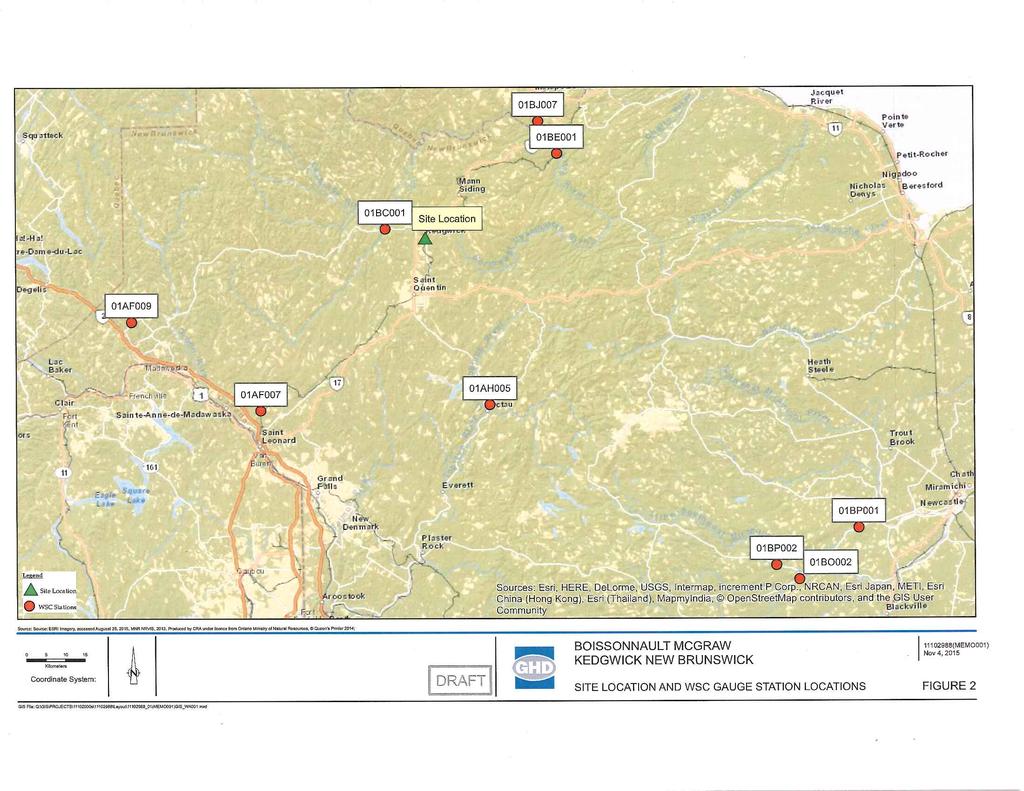
7 2.2 Name of the Undertaking Water supply source assessment for the Communauté rurale de Kedgwick, NB. 2.3 Project Overview Complete a water supply source assessment for the possible development of an additional water supply for the municipality. The demand for water withdrawal continues to increase for the Village due to population growth and increasing commercial/industrial pressures. The proposed well would be located approximately 100 metres to the northeast of the existing groundwater production well PW-2 and within Zone A of the current wellfield protection area for the Communauté rurale de Kedgwick wellfield. The proponent would like to undertake the proposed testing work as soon as possible following approval of the undertaking. 2.4 Purpose/Rational/Need for the Undertaking The purpose for the undertaking is to provide the Communauté rurale de Kedgwick with an additional water resource to meet its daily requirements. The additional water resource would extract water from the same aquifer as the two existing production wells. The current wellfield was developed in 1982, with the construction of two production wells (PW-1 and PW-2) in a sandy gravel aquifer along the western bank of Hailes Brook. In the early 1990s, PW-1 was abandoned when the pump could not be recovered from the well. At this time, PW-3 was constructed to replace PW-1. The project details are presented in Item 6 of the attached WSSA application. In summary, one 150 mm diameter well will be constructed and preliminary testing completed. If the test results are positive, a 200 or 250 mm diameter production well would be constructed and pump tested. Once the well is successfully constructed and tested, additional information pertaining to the connection to the water supply system will be provided to your department for evaluation prior to undertaking the construction activities. 2.5 Project Location The potential drill target is located on property PID # , approximately 100 metres to the northeast of the existing groundwater production well PW-2 (Figure 1). This location was selected due to the close proximity to existing water infrastructure (pipeline and pumphouse), and the anticipated presence of a significant gravel aquifer in the area. The coordinates for the target area are north, west. 2.6 Sitting Considerations The stratigraphy intersected during drilling of the municipal well in 1982 includes 6.7 to 7.6 metres of sandy gravel underlain by bedrock. In addition, the well would be located close to existing water distribution infrastructure, thereby minimizing cost and potential impacts of connecting the well to the water supply system. This location was selected in consultation with representatives of the Communauté rurale de Kedgwick and Boissonault McGraw. GHD Report for Communauté rurale de Kedgwick - Environmental Impact Assessment Registration (1) 2
8 Watercourses or wetlands have been identified within 60 metres of the proposed drill target area. Details on the location of nearby watercourses and wetlands are provided in Item 9 of the attached WSSA application. The wetland and watercourses are also identified on Figures 1 and Physical Components of the Project The drill target is located approximately 100 metres to the northeast of the existing groundwater production well PW-2 (Figure 2). The location of the existing production wells are identified on Figure 2. The undertaking pertains to the construction and testing of wells in the study area. Once the wells have been developed, additional information pertaining to related infrastructure requirements (pipeline connections, pump house construction, etc.) will be provided to your department prior to undertaking the work. It is expected that the undertaking will require work within 30 metres of a watercourse or wetland. Should work be required within this 30 metre buffer, a watercourse alteration application will be submitted prior to undertaking this work. There will be minimal increases in vehicle traffic due to the undertaking. Some temporary storage of materials may be required on-site during the construction activities, but minimal storage will be required during the drilling and testing activities Construction Details The construction of the proposed additional water well and pump test activities, as per the New Brunswick Clean Water Act, will be carried out by a licensed Well Driller under the supervision of CRA personnel. The following describes the work that is to be completed for the drilling of the additional well: Complete underground clearances prior to commencing drilling activities. Install and maintain sediment and erosion control structure over the course of well construction, development and pump testing (if required). Construction of one 150 mm diameter test well at the target site using standard drilling method (air rotary) to an approximate depth of 6-10 metres below ground surface (mbgs), with a 150 mm steel casing installed into to the gravel formation. The well will be logged by an experienced CRA professional. A preliminary yield estimate will be completed based on airlift volumes following construction of the test well. Preliminary groundwater samples will be collected after initial development and analyzed for general chemistry and metals. If the estimated yield and preliminary chemistry results are acceptable, a mm diameter test well with stainless steel screen will be constructed near the initial well. A three 30 minute step tests will be completed on the test well, followed by a 72 hour pump test, to evaluate the aquifer yield. Water levels will be measured in the mm diameter test well, the 150 mm diameter monitoring well and the existing production wells during the pump test. Water samples will be collected at 24 hour interval during the test for chemical analysis. GHD Report for Communauté rurale de Kedgwick - Environmental Impact Assessment Registration (1) 3
9 A detailed report on the hydrogeological investigation will be submitted to the NB Department of Environment office upon completion of the testing program. The report will meet the requirements outlined in NBDELG s Water Supply Source Assessment Guidelines, and will include well logs, pump test information, chemistry data and yield estimate. The drilling activities will be completed during daytime hours. Pump testing activities will be completed for a continuous 72 hour period. Refueling of the equipment used during the construction activities will either be completed off-site or at a designated on-site location Operation and Maintenance Periodic maintenance of the well will be required from time to time, and may include removing/replacing the pump, well re-development activities, etc. Operation and maintenance of the well is not expected to cause significant environmental impacts Future Modification, Extensions, or Abandonment Details on any construction activities necessary to connect the new well to the existing water supply (pipeline installation, pump house construction, etc.) will be provided for approval prior the proceeding with the work Project Related Document The Water Supply Source Assessment Initial Application document is presented as Attachment A. 3. Description of Existing Environment 3.1 Physical and Natural Features The site topography near the target area is relatively flat, with an approximate elevation of 300 metres above sea level. The water from Hailes brook flows from the north to the south. The regional groundwater flow is expected to be south. Watercourses and wetlands have been identified within 60 metres of the proposed drill target area. There is one NBDELG regulated wetlands located approximately 5 metres east of the drill target area. Hailes Brook is located approximately 10 metres east of the target area as well. The existing municipal well (PW-2) is located within 100 metres of the target area. The target area is therefore located within Zone A of the wellfield. The proposed well would extract water from the same aquifer as the current municipal wells. However, a hydrogeological study of Hailes Brook indicated that the area can provide the required water based on recharge estimates and low flow calculations (see WSSA, Attachment A). 3.2 Cultural Features The target area is located on the Communauté rurale de Kedgwick property. There are no cultural features identified near the target area. GHD Report for Communauté rurale de Kedgwick - Environmental Impact Assessment Registration (1) 4
10 3.3 Existing and Historic Land Use The target area is located on the Communauté rurale de Kedgwick property. A description of the neighbouring land uses are provided as Item 7 of the attached WSSA application. 4. Summary of Environmental Impacts Environmental impacts related to the construction and testing of the proposed wells will be minimal, as described above. If the estimated yield and water chemistry results are acceptable, the new well will be connected to existing underground piping and details for this work will be provided to your department prior to undertaking the work. 5. Summary of Proposed Mitigation The drill site will be equipped with spill kit Equipment will be inspected daily to ensure it is in good working order and free of leaks Vehicle fueling and maintenance must occur at least 30 m away from any watercourse, either off-site or at a designated on-site location Sediment and erosion controls will be installed and maintained over the course of the well construction, development and pump testing (if required) All work (except for the pump testing) will be completed during daylight hours, to minimize disturbance to the local area 6. Public Involvement The Communauté rurale de Kedgwick will seek and consider public input in relation to the proposed project. Individuals, companies, agencies, organized interest groups, and others that may be affected by the project will be contacted, made aware of the undertaking, explained the details of the project and asked for comments, related to the project. A report documenting the public involvement process will be submitted to the Department of the Environment within 60 days of this registration. 7. Approval of the Undertaking The following permits, licenses, approvals, and permissions are required for this undertaking: a) Water Supply Source Assessment Initial Application Approval by NBDELG 8. Funding This project is being funded by the Communauté rurale de Kedgwick, NB. GHD Report for Communauté rurale de Kedgwick - Environmental Impact Assessment Registration (1) 5
11 9. Signature Please accept this EIA Registration for the construction of a back-up well. Signature of Chief Executive Date Francis Bérubé Directeur général Communauté rurale de Kedgwick GHD Report for Communauté rurale de Kedgwick - Environmental Impact Assessment Registration (1) 6

12 SITE LOCATION m 0.02 KEDGWICK, NB EIA REGISTRATION WATER SUPPLY SOURCE ASSESSMENT SITE LOCATION Nov 26, 2015 FIGURE 1 CAD File: I:\CAD\8-chars\ \ \ \ REPORTS\ (001)\ (001)GN\ (001)GN-FR001.dwg
13 MAINTENANCE GARAGE PID # LUMBERMILL PID # PID # GAS BAR GRAVEL PIT FORMER DOT GARAGE PID # PID # ROUTE # 17 PROPOSED WELL PID # PW-2 PW-1 COMMERCIAL PROPERTY PID # PID # GRAVEL PIT LEGEND: PROPERTY LINES (COLOURED WHITE ON FIGURE) 500 METRE RADIUS FROM PROPOSED ADDITIONAL WATER WELL STREAM LOCATION (GEONB) REGULATED WETLANDS (NB DELG) POTABLE WATER SUPPLY WELL LOCATION PROPOSED NEW POTABLE WATER SUPPLY WELL LOCATION m 0.2 COMMUNAUTÉ RURALE DE KEDGWICK KEDGWICK, NB EIA REGISTRATION WATER SUPPLY SOURCE ASSESSMENT SITE PLAN Nov 26, 2015 FIGURE 2 CAD File: I:\CAD\8-chars\ \ \ \ REPORTS\ (001)\ (001)GN\ (001)GN-FR002.dwg
14 Attachment A Water Supply Source Assessment - Initial Application, Communauté rurale de Kedgwick, NB GHD Report for Communauté rurale de Kedgwick - Environmental Impact Assessment Registration (1)
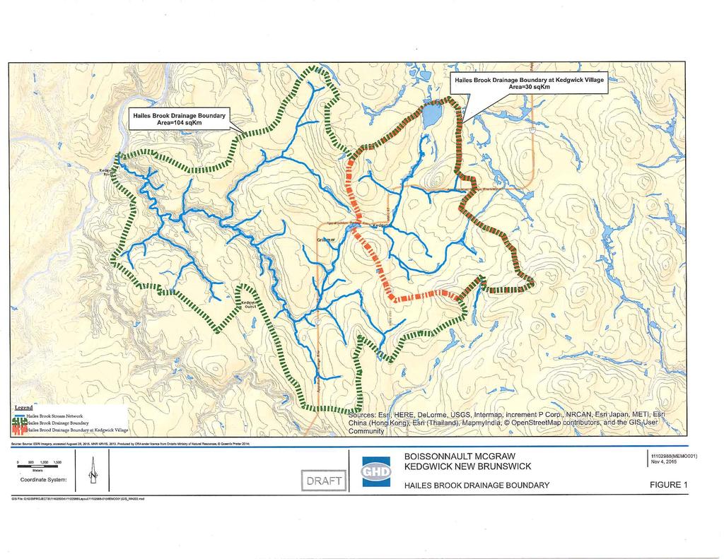
15 November 25, 2015 Reference No Department of Environment and Local Government 20 McGloin Street, 3rd Floor North Wing PO Box 6000 Fredericton, NB E3A 5T8 Re: Water Supply Source Assessment Initial Application Communauté rurale de Kedgwick, NB GHD Limited (GHD) has been retained by Boisonnault McGraw, on behalf of the Communauté rurale de Kedgwick, to complete a hydrological study for the future development of an additional water supply for the municipality. The demand for water withdrawal continues to increase for the Village due to population growth and increasing commercial/industrial pressures. The Communauté rurale de Kedgwick currently obtains their water supply from a wellfield located along Hailes Brook. Due to increasing water demands, the Village requires additional water resources to meet its daily requirements. It is our intention to complete the proposed testing work as soon as possible following receipt of NBDELG approval. The current wellfield was developed in 1982, with the construction of two production wells (PW-1 and PW-2) in a sandy gravel aquifer along the western bank of Hailes Brook. In the early 1990s, PW-1 was abandoned when the pump could not be recovered from the well. At this time, PW-3 was constructed to replace PW-1. The proposed additional well would be located approximately 100 metres to the northeast of the current well PW-2 (Figure 1). The proposed test location would be located within Zone A of the current wellfield protection area for the wellfield. This letter is an application to initiate a water supply source assessment project for the Communauté rurale de Kedgwick, as defined in the Water Supply Source Assessment Guidelines document dated March 14, Name of proponent: Communauté rurale de Kedgwick. 1) Location of drill targets and purpose of the proposed water supply: The potential drill target is located on property PID # , approximately 100 metres to the northeast of the existing groundwater production well PW-2 (Figure 1). This location was GHD Limited 466 Hodgson Road Fredericton New Brunswick E3C 2G5 Canada T F W
16 selected due to the close proximity to existing water infrastructure (pipeline and pumphouse), and the anticipated presence of a significant gravel aquifer in the area. The purpose for the undertaking is to provide the Communauté rurale de Kedgwick with an additional water resource to meet its daily requirements. The additional water resource would extract water from the same aquifer as the two existing production wells. It is noted that a hydrological study of Hailes Brook was completed by GHD in November 2015 to determine if there is sufficient recharge within the creek system to sustain the installation of additional municipal water wells (Hailes Brook Drainage Basin Hydrological Study, GHD, November 4, 2015 Appendix A). Analysis shows the minimum predicted low flow for Hails Brook at Kedgwick to be approximately 570,000 imperial gallons per day (igpd). The municipality is currently using 180,000 igpd. Assuming that all of the recharge for the wellfield comes from the brook, this would equate to approximately 32% of the base low flow for Hails Brook. Should a second well be drilled in the area to augment the capacity by 50%, the total water withdrawal (270,000 igpd) would equate to less than 50% of the 7Q 10 base flow, leaving ample water for sustaining the freshwater aquatic life in the brook. The above represents the worst case scenario, as the brook is not the only source of recharge water for the aquifer. Furthermore, the drainage area for Hails Brook at Kedgwick is estimated at 30 km 2. Assuming an annual precipitation of 1 meter, and an infiltration/recharge rate of 10% (which is conservative), the available water for the drainage basin can be calculated at 1.8M igpd on average. Given the maximum projected municipal water consumption of 270,000 igpd, this only represents 15% of the available recharge for the area. Based on this information, the Hails Brook drainage basin could sustain the additional water required by the municipality. 2) Required water quantity (in m 3 /day) and/or required pumping rate: The municipality is currently using 180,000 igpd. The production wells PW-1 and PW-2 were both rated at 90,000 igpd during a pump test completed in Ideally, the additional water supply would have a similar yield to the existing municipal well. Based on the above information, the estimated minimum water requirement for the proposed water supply is 90,000 igpd. 3) List alternate water supply sources in area (including municipal systems): There are no other known municipal water supplies in the area. 4) Area hydrogeology: The stratigraphy intersected during drilling of the municipal well in 1982 includes 6.7 to 7.6 metres of sandy gravel underlain by bedrock. The water from Hailes brook flows from the north to the south. The regional groundwater flow is expected to be south Doucet-1 - WSSA Step 1 Approval Application.docx 2
17 5) Proposed hydrogeological testing and work schedule: Following approval of the undertaking from NB Department of Environment and Local Government, CRA will supervise the drilling of one 150 mm diameter test well at the drill target site (Figure 1). The well will be logged by an experienced CRA professional and the drilling contractor will be a licensed well driller. A preliminary yield estimate will be completed based on airlift volumes following construction of the test well. Preliminary groundwater samples will be collected after initial development and analyzed for general chemistry and metals. If the estimated yield and preliminary chemistry results are acceptable, a mm diameter test well will be constructed near the initial well. A step test will be completed on the test well, followed by a 72 hour pump test, to evaluate the aquifer yield. Water levels will be measured in the mm diameter test well and the 150 mm diameter monitoring well during the pump test. Water samples will be collected at 24 hour interval during the test for chemical analysis. A detailed report on the hydrogeological investigation will be submitted to the NB Department of Environment office upon completion of the testing program. The report will meet the requirements outlined in NBDELG s Water Supply Source Assessment Guidelines, and will include well logs, pump test information, chemistry data and yield estimate. The proponent would like to undertake the proposed testing work as soon as approval to proceed is received. 6) Existing pollution or contamination hazards within a (minimum) 500 m radius of the proposed drill targets. The following constraints have been identified within 500 metres of the proposed drill target area: a) The drill target area is located adjacent to Hales Brook within a vacant lot approximately 350 metres east of Highway 17. b) A former rail road track, currently owned by Natural Resources and Energy, is located approximately 50 metres east of the drill target area. The rail corridor is currently used as an ATV/snowmobile trail. c) A commercial property (kitchen cabinet manufacturer) is located approximately 350 metres southwest of the drill target area (PIDs # and # ). d) Gravel pits are located approximately 350 metres southeast and 400 metres northeast of the drill target area. e) A former Department of Transportation maintenance garage is located approximately 450 metres to the northwest of the drill target area. These properties (PIDs # and ) are listed on Service New Brunswick Land Gazette as a former petroleum Doucet-1 - WSSA Step 1 Approval Application.docx 3
18 storage site and also registered under the New Brunswick Remediation Management program. In addition, the following constraints have been identified slightly over 500 m of the proposed drill target area: f) A commercial truck maintenance garage is located approximately 700 metres to the northeast of the target area. This property (PID # ) is listed on Service New Brunswick Land Gazette as a petroleum storage site. g) A fuel/gasoline gas bar is located approximately 725 metres to the northeast of the target area. This property (PID # ) is listed on Service New Brunswick Land Gazette as a petroleum storage site and registered under the New Brunswick Remediation Management program. h) A lumber mill is located approximately 750 metres to the northeast of the drill target area. This property (PID # ) is listed on Service New Brunswick Land Gazette as a petroleum storage site. All of these properties noted above are located within the Communauté rurale de Kedgwick Wellfield Protection Area for the existing municipal well. Although the land uses listed above represent potential contamination hazards, the current municipal well is located in the same target area and has not been affected by the activities listed above. 7) Groundwater use problems (quantity or quality) that have occurred in the area. The water chemistry (organic and inorganic) for the current municipal wells PW-2 and PW-3 (April 2015) is included as Appendix B. All parameters analyzed for meet the Canadian Drinking Water Guidelines. There have been no quantity or quality issues reported for the both current municipal wells. The water chemistry for the proposed additional well would be expected to be similar to the chemistry for the current municipal wells. 8) Watercourse(s) within 60 m of the proposed drill targets. A watercourse (Hailes Brook) is located approximately 40 metres to the east of the drill target area. There is an NBDELG regulated wetlands located within 25 metres to the east of the proposed drill target area. 9) Site supervisory personnel involved in the source development (municipal officials, consultants and drillers). Client Contact: o Francis Bérubé (Directeur Général, Communauté Rural de Kedgwick NB) o crkedgwick.fb@bellaliant.com o Phone: Doucet-1 - WSSA Step 1 Approval Application.docx 4
19 Project Manager/Senior Hydrogeologist: Roger Poirier (Senior Hydrogeologist, GHD) o roger.poirier@ghd.com o Phone: Site Supervisors: Mario Theriault / Mike Gaines / Mike Graves (Senior Technicians, GHD) Licensed Well Driller: A qualified licensed well driller will be identified to complete the drilling and pump test activities. 10) 1:10,000 map and/or recent air photo identifying: Proposed location of drill targets and property PID Domestic or production wells within a 500 m radius from the drill target Any potential hazards identified in Question 6 A 1:10,000 site plan identifying the potential drill target is attached as Figure 1. Other than the Communauté rurale de Kedgwick production well adjacent to the drilling target, there are no other known water supplies within a 500 m radius of the target area. The features discussed in Question 6 above are also identified on Figure 1 for reference purposes. 11) Land use/zoning map of the area. Superimpose drill targets on this map. Land use/zoning map for the area of the drilling target is not available. The property is wooded and hosts a pump house and two production wells. The properties immediately to the south of the drilling target area are zoned residential (R2A). 12) Contingency plan for open loop earth energy systems. Not applicable to this project. We trust this information is sufficient for your evaluation at this time. Please contact our office should there be questions. Sincerely, GHD Limited Roger Poirier, M.A.Sc., P.Eng. Mario Theriault, Ctech. RP/ad/1 Encl. cc: André Boisonnault Doucet-1 - WSSA Step 1 Approval Application.docx 5
 500 METRE RADIUS FROM PROPOSED ADDITIONAL WATER WELL STREAM LOCATION (GEONB)")

20 MAINTENANCE GARAGE PID # LUMBERMILL PID # PID # GAS BAR GRAVEL PIT FORMER DOT GARAGE PID # PID # ROUTE # 17 PROPOSED WELL PID # PW-2 PW-1 COMMERCIAL PROPERTY PID # PID # GRAVEL PIT LEGEND: PROPERTY LINES (COLOURED WHITE ON FIGURE) 500 METRE RADIUS FROM PROPOSED ADDITIONAL WATER WELL STREAM LOCATION (GEONB) REGULATED WETLANDS (NB DELG) POTABLE WATER SUPPLY WELL LOCATION PROPOSED NEW POTABLE WATER SUPPLY WELL LOCATION m 0.2 BOISSONEAULT McGRAW COMMUNAUTÉ RURALE DE KEDGWICK, NB WATER SUPPLY SOURCE ASSESSMENT Nov 26, 2015 SITE PLAN FIGURE 1 CAD File: I:\CAD\8-chars\ \ \ \ CORR\ (DOUCET001)\ (DOUCET001)GN\ (DOUCET001)GN-FR001.dwg
21 Appendix A Hailes Brook Drainage Basin Hydrological Study GHD Water Supply Source Assessment, Initial Application, Communauté rurale de Kedgwick, NB (1)
22
23
24
25
26
27
28
29
30
31
WATER SUPPLY SOURCE ASSESSMENT NEW PRODUCTION WELL EIA REGISTRATION DOCUMENT. Prepared for:
 WATER SUPPLY SOURCE ASSESSMENT NEW PRODUCTION WELL EIA REGISTRATION DOCUMENT Prepared for: Village of Hillsborough 2849 Main Street Hillsborough, NB E4H 2X7 Prepared by: Crandall Engineering Ltd. 1077
NEW BRUNSWICK DEPARTMENT OF ENVIRONMENT AND LOCAL GOVERNMENT. Environmental Impact Assessment WATER SUPPLY SOURCE ASSESSMENT GUIDELINES
 NEW BRUNSWICK DEPARTMENT OF ENVIRONMENT AND LOCAL GOVERNMENT Environmental Impact Assessment WATER SUPPLY SOURCE ASSESSMENT GUIDELINES Department of Environment and Local Government January 2012 Table
NEW BRUNSWICK DEPARTMENT OF ENVIRONMENT AND LOCAL GOVERNMENT. Environmental Impact Assessment WATER SUPPLY SOURCE ASSESSMENT GUIDELINES
 NEW BRUNSWICK DEPARTMENT OF ENVIRONMENT AND LOCAL GOVERNMENT Environmental Impact Assessment WATER SUPPLY SOURCE ASSESSMENT GUIDELINES Department of Environment and Local Government April 2017 Table of
Environmental Impact Assessment Registration (Draft)
") Environmental Impact Assessment Registration (Draft) McCain Foods (Canada), Grand Falls, NB i Table of Contents Acronyms and Abbreviations 1.0 The Proponent 1 1.1 Name of the Proponent...1 1.2 Project
Environmental Impact Assessment Registration (Draft) McCain Foods (Canada), Grand Falls, NB i Table of Contents Acronyms and Abbreviations 1.0 The Proponent 1 1.1 Name of the Proponent...1 1.2 Project
Environmental Impact Assessment Registration for Nicholson s Waste Management Ltd. Septage De-watering Facility
 Environmental Impact Assessment Registration for Nicholson s Waste Management Ltd. Septage De-watering Facility Submitted to: NB Department of the Environment and Local Government Sustainable Development
Guideline for the Screening of Projects in a Drainage Area of Concern Adjacent to Parlee Beach
 Guideline for the Screening of Projects in a Drainage Area of Concern Adjacent to Parlee Beach Background The water quality at Parlee Beach has been identified as an issue of concern, and New Brunswickers
Using Fractran Fracture Flow Modeling in Tandem with Modflow to Assist in the Development of Wellfield Protection Zones for Municipal Wells in Bedrock
 Using Fractran Fracture Flow Modeling in Tandem with Modflow to Assist in the Development of Wellfield Protection Zones for Municipal Wells in Bedrock T.K. Wiezel 1, G.G. Violette 1 and S.T. Hamilton 2
patersongroup Phase I - Environmental Site Assessment Vacant Land, Strandherd Drive at Kennevale Drive Ottawa, Ontario Prepared For Regional Group
 Geotechnical Engineering patersongroup Environmental Engineering Hydrogeology Geological Engineering Materials Testing Building Science Vacant Land, Strandherd Drive at Kennevale Drive Ottawa, Ontario
CRAIG HYDROGEOLOGIC INC.
 CRAIG HYDROGEOLOGIC INC. Groundwater and Soil Contamination Groundwater Protection Resource Development Site Remediation Site Professional CHATHAM WELLFIELD TH3-2016 GROUNDWATER EXPLORATION 2016 EIA REGISTRATION
Dear Mr. Maguire: Re: FINAL EIA Registration Existing Water Supply, Sainte-Marie-Saint-Raphael DFO- SCH, NB
 1 December, 2017 TE161442 (Sent via email) Mr. David Maguire Sustainable Development, Planning & Impact Evaluation Branch Department of Environment and Local Government 20 McGloin Street PO Box 6000 Fredericton,
Georgetown Water Storage Class Environmental Assessment Study
 Georgetown Water Storage Class Environmental Assessment Study Public Information Centre Cedarvale Community Centre 181-185 Main Street South Thursday, September 4th, 2008 6:30 p.m. 8:30 p.m. Why are we
patersongroup Phase I Environmental Site Assessment Vacant, Undeveloped Land 1021 Thomas Spratt Place Ottawa, Ontario Prepared For
 Geotechnical Engineering patersongroup Environmental Engineering Hydrogeology Geological Engineering Materials Testing Building Science Phase I Environmental Site Assessment Vacant, Undeveloped Land 1021
GUIDE TO THE DEVELOPMENT OF A MINING AND RECLAMATION PLAN IN NEW BRUNSWICK
 PROVINCE OF NEW BRUNSWICK DEPARTMENT OF ENERGY AND RESOURCE DEVELOPMENT Minerals and Petroleum Development Branch GUIDE TO THE DEVELOPMENT OF A MINING AND RECLAMATION PLAN IN NEW BRUNSWICK Guide to the
Land Reclamation Site Siting and Application Guidelines
 Department of Environment and Local Government Land Reclamation Site Siting and Application Guidelines Rationale In an effort to reduce the cost associated with the transportation of demolition wastes,
ENVIRONMENT ACT TERMS OF REFERENCE NOVA SCOTIA DEPARTMENT OF TRANSPORTATION AND PUBLIC WORKS. Beaver Bank Bypass
 ENVIRONMENT ACT TERMS OF REFERENCE NOVA SCOTIA DEPARTMENT OF TRANSPORTATION AND PUBLIC WORKS Beaver Bank Bypass Highway 101 to the Beaver Bank Road Halifax County, NS NOVA SCOTIA DEPARTMENT OF THE ENVIRONMENT
City of Fredericton. Environmental Impact Assessment Registration. Type of Document: Preliminary. Project Name: Lincoln Lagoon Decommissioning
 Environmental Impact Assessment Registration Type of Document: Preliminary Project Name: Project Number: Prepared By: Christine Boutot, EIT Reviewed By: Daryl Burke, M.Sc.E., P.Eng. exp Services Inc. 1133
ENVIRONMENTAL ASSESSMENT REGISTRATION
 ENVIRONMENTAL ASSESSMENT REGISTRATION PORT HARMON CHANNEL AND HARBOUR DREDGING Submitted to: Department of Environment Environmental Assessment Division May 2004 ENVIRONMENTAL ASSESSMENT REGISTRATION PORT
Standard for Commercial Vehicle Salvage Facilities
 Standard for Commercial Vehicle Salvage Facilities Effective December 1, 2019 Crown copyright, Province of Nova Scotia, 2019 January 2019 ISBN 978-1-55457-918-1 Table of Contents 1 Applicability... 1 2
WM2013 Conference, February 24 28, 2013, Phoenix, Arizona, USA
 Scheduling the Remediation of Port Hope: Logistical and Regulatory Challenges of a Multiple Site Urban Remediation Project 13119 Andrea Ferguson Jones, P.Geo.*, Angela Lee, MASc., P.Eng., PMP* and Tim
REGION OF PEEL PUBLIC WORKS DESIGN, SPECIFICATIONS & PROCEDURES MANUAL LINEAR INFRASTRUCTURE
 REGION OF PEEL PUBLIC WORKS DESIGN, SPECIFICATIONS & PROCEDURES MANUAL LINEAR INFRASTRUCTURE GUIDELINES FOR HYDROGEOLOGIC ASSESSMENT AND REPORTING REQUIREMENTS NEW DEVELOPMENTS ON MUNICIPAL SERVICES REVISED
Highland Gate Developments Inc. (SUB ) Construction Impact Mitigation Plan No. 1 (Phase 1 Site Alteration Works) February 2017.
 Construction Impact Mitigation Plan No. 1 (Phase 1 Site Alteration Works) February 2017.") Highland Gate Developments Inc. (SUB-2015-01) Construction Impact Mitigation Plan No. 1 (Phase 1 Site Alteration Works) February 2017 Submitted by: SCS Consulting Group Ltd 30 Centurian Drive, Suite 100
Highland Gate Developments Inc. (SUB-2015-01) Construction Impact Mitigation Plan No. 1 (Phase 1 Site Alteration Works) February 2017 Submitted by: SCS Consulting Group Ltd 30 Centurian Drive, Suite 100
August 28, 2018 File: PE2122-LET.01
 patersongroup August 28, 2018 File: PE2122-LET.01 Minto Communities 200-180 Kent Street Ottawa, Ontario K1P 0B6 Attention: Mr. Kevin Harper Consulting Engineers 154 Colonnade Road South Ottawa, Ontario
Environmental Assessment Approval
 Environmental Assessment Approval Approval Date: Original Dated April 20, 2012 Trimper Sand and Gravel Pit Expansion Ivan H. Trimper Construction Ltd., Proponent Annapolis County, Nova Scotia The Trimper
STANDARDS AND GUIDELINES FOR MUNICIPAL WATERWORKS, WASTEWATER AND STORM DRAINAGE SYSTEMS
 STANDARDS AND GUIDELINES FOR MUNICIPAL WATERWORKS, WASTEWATER AND STORM DRAINAGE SYSTEMS January 2006 Drinking Water Branch Environmental Policy Branch Environmental Assurance Division Pub. No.: T/840
TRANSPORTATION AND ENVIRONMENTAL SERVICES Rapid Transit Initiative
 REGION OF WATERLOO TRANSPORTATION AND ENVIRONMENTAL SERVICES Rapid Transit Initiative TO: Chair Jim Wideman and Members of the Planning and Works Committee DATE: FILE CODE: D10-20/RT SUBJECT: PROPOSED
DESCRIPTION OF THE PROJECT CHANGE
 Stantec Consulting Ltd. 70 Southgate Drive, Unit 1 Guelph, Ontario N1G 4P5 September 19, 2012 Stantec File: 160960584 Ministry of the Environment Environmental Approvals Access & Service Integration Branch
October 2, 2015 EAB File #: Transaction #:
 Ministry of Environment Environmental Assessment Branch 4 th floor, 3211 Albert Street Regina, Saskatchewan S4S 5W6 Phone: 306.787 5971 Fax: 306 787 0930 October 2, 2015 EAB File #: 2015-013 Transaction
The Contract Documents may be examined at the following locations:
 ADVERTISMENT FOR BIDS Separate sealed Bids for the replacement of Municipal Production Well will be received by the Department of Public Services at 301 W. Main Street, Owosso, MI 48867 until 2:00 p.m.
CORNERSTONE RIVER VALLEY VILLAGE FILING NO. 1 STORMWATER MANAGEMENT PLAN
 CORNERSTONE RIVER VALLEY VILLAGE FILING NO. 1 STORMWATER MANAGEMENT PLAN SITUATED IN THE SW ¼ OF SECTION 18, T.2S., R.67W., OF THE 6 TH P.M. COUNTY OF ADAMS, STATE OF COLORADO PREPARED FOR: Thornton Cornerstone
APPLICATION FOR A PERMIT TO CONSTRUCT A WATER WELL IN THE LOWER PLATTE NORTH NATURAL RESOURCES DISTRICT
 APPLICATION FOR A PERMIT TO CONSTRUCT A WATER WELL IN THE LOWER PLATTE NORTH NATURAL RESOURCES DISTRICT DNR & NRD USE ONLY Permit No. Date Approved/Denied NRD Representative Permit Type: New, Replacement
Paul L. Plato, R.G. Senior Hydrogeologist
 Paul L. Plato, R.G. Senior Hydrogeologist Expertise Hydrogeology/Geology/Geophysics Geographic Information Systems/Database Management Education B.S., Geophysics, University of Arizona, 1986 Registrations
ENVIRONMENTAL SCREENING REPORT
 ENVIRONMENTAL SCREENING REPORT Pursuant to the Canadian Environmental Assessment Act (CEA Act) SCREENING SUMMARY TransCanada PipeLines Limited (TransCanada) is proposing to conduct a contaminant sampling
Refer to Chapter 3.0 (Description of Development) for a detailed site and development description.
 for a detailed site and development description.") 7. WATER: HYDROGEOLOGY & HYDROLOGY 7.1 Introduction This chapter of the EIAR comprises of an assessment of the likely impact of the proposed development on the surrounding surface water and hydrogeological
7. WATER: HYDROGEOLOGY & HYDROLOGY 7.1 Introduction This chapter of the EIAR comprises of an assessment of the likely impact of the proposed development on the surrounding surface water and hydrogeological
City of Guelph Southwest Quadrant Municipal Class Environmental Assessment
 City of Guelph Southwest Quadrant Municipal Class Environmental Assessment Tuesday April 15 th, 2008 Agenda TIME 6:00 pm 7:00 pm Open House Registration DESCRIPTION Opportunity for participants to view
Strength. Performance. Passion. Paris Pit CAP. April 30, Permit To Take Water Application Holcim (Canada) Inc.
 Inc.") Strength. Performance. Passion. Paris Pit CAP April 30, 2013 Permit To Take Water Application 2012 Holcim (Canada) Inc. Agenda Welcome Minutes from Last Meeting Dufferin Paris Pit - General Update Review
Strength. Performance. Passion. Paris Pit CAP April 30, 2013 Permit To Take Water Application 2012 Holcim (Canada) Inc. Agenda Welcome Minutes from Last Meeting Dufferin Paris Pit - General Update Review
Rock Fill Layer Management and Maintenance Plan Former BNSF Site 13 Highway 99 Eugene, Oregon
 Rock Fill Layer Management and Maintenance Plan 13 Highway 99 Prepared for: Half Moon LLC P.O. Box 25112 97402 PBS Project No. 51833.000 Rock Fill Layer Management and Maintenance Plan TABLE OF CONTENTS
Jp2g Consultants Inc.
 Consultants Inc. J.M. Janota, P.Eng., M.Sc. J.E. Hunton, MCIP, RPP ENGINEERS PLANNERS PROJECT MANAGERS April 2, 2012 Municipality of Hastings Highlands 33011 Hwy. 62 North P.O. Box 130 Maynooth, Ontario,
Wetland Compensation in New Brunswick
 Wetland Compensation in New Brunswick Wetlands provide important functions and must be protected. This is why we must consider potential impacts to the environment when evaluating a proposed project that
Solid Non-Hazardous Waste Disposal Site Inspection Report
 Ministry of the Environment Ministère de l Environnement Solid n-hazardous Waste Disposal Site Inspection Report Client: Inspection Site Address: The Corporation of the Municipality of Southwest Middlesex
MR. & MRS. HERBERT DAY 5595 Hartnell Road Site 7A - 5, R.R. 8 VERNON, B.C. V1T 8L6
 EVALUATION OF WATER SUPPLY FOR A PkOPOSED SUBDIVISION LOCATED NORTHWEST OF THE INTERSECTION OF HARTNELL ROAD AND DAY ROAD, AT VERNON, B.C. Prepared for MR. & MRS. HERBERT DAY 5595 Hartnell Road Site 7A
Chemical Storage Report Wellfield Protected Area Designation Order
 DEPARTMENT OF ENVIRONMENT Chemical Storage Report Wellfield Protected Area Designation Order Name of Applicant: Site Address: Site Property Identification Number: Date: DENV File Number: CHEMICAL EVALUATION
Site Location AQUARION WATER COMPANY CANNONDALE WELL FIELD WILTON, CONNECTICUT
 Site Location PW-1 O:\DWG\Aquarion\Wilton\2018\F1_SLM.dwg, Layout1, 2/9/2018 4:18:14 PM, AcroPlotTemp2644.pc3 SOURCE: USGS TOPOGRAPHIC QUADRANGLE NORWALK NORTH, CONNECTICUT (PHOTOINSPECTED 1975). CONNECTICUT
SECTION 10 UTILITIES
 SECTION 10 UTILITIES Virtually every highway construction project in the State of New Jersey impacts utility facilities. The Designer shall examine and seek alternatives to minimize or eliminate the impact
August 29, 2013 Project No /4000
 August 29, 2013 Project No. 12-1127-0047/4000 Craig Bellinger, C.E.T. R.W. Tomlinson Limited 5597 Power Road Ottawa, Ontario K1G 3N4 REVISED HYDROGEOLOGICAL ASSESSMENT, 891 JINKINSON ROAD CUMBERLAND READY-MIX
Draft for Discussion. Environmental Assessment Terms of Reference. Waste Management of Canada Corporation, Ottawa Waste Management Facility
 Draft for Discussion Environmental Assessment Terms of Reference Waste Management of Canada Corporation, Ottawa Waste Management Facility January 12, 2006 Table of Contents Page 1. Introduction...1 2.
Strathcona County Functional Planning Study Highway 15:06 From Range Road 220 to Highway 830 A P P E N D I X G BRIDGE ASSESSMENT E00311A
 Strathcona County Functional Planning Study Highway 15:06 From Range Road 220 to Highway 830 A P P E N D I X G BRIDGE ASSESSMENT E00311A BF 73649 E/W Bridge Culverts Highway 15 Crossing Astotin Creek Bridge
This report updates a Phase I-Environmental Site Assessment report prepared by Paterson, dated March 2008, as detailed below.
 Consulting Engineers October 13, 2016 Bassi Construction 2575 Del Zotto Avenue Ottawa, Ontario K1T 3V7 Attention: Subject: Phase I - Environmental Site Assessment Update Residential and Vacant Property
Cox's Construction Ltd. P.O.Box 157 Lawn A0E-2E0 Tel: (709) Fax: (709)
 Fax: (709)") Cox's Construction Ltd. P.O.Box 157 Lawn A0E-2E0 Tel: (709) 873-2301 Fax: (709) 873 2567 Cells: (709) 873-7731/873-7730/ 697-0861 September 23, 2016 Government of Newfoundland and Labrador Department of
Cox's Construction Ltd. P.O.Box 157 Lawn A0E-2E0 Tel: (709) 873-2301 Fax: (709) 873 2567 Cells: (709) 873-7731/873-7730/ 697-0861 September 23, 2016 Government of Newfoundland and Labrador Department of
Appendix D. Fisheries and Oceans Canada (DFO) Letter of Advice
 Letter of Advice") The City of Winnipeg Bid Opportunity No. 851-2017 Template Version: C420170317 - RW Appendix D Fisheries and Oceans Canada (DFO) Letter of Advice Fisheries and Oceans Canada Pêches et Océans Canada 103-1800
The City of Winnipeg Bid Opportunity No. 851-2017 Template Version: C420170317 - RW Appendix D Fisheries and Oceans Canada (DFO) Letter of Advice Fisheries and Oceans Canada Pêches et Océans Canada 103-1800
June 28, Test Well Flow Rate Report MSD Underground Injection Control Wells City of Richlawn Louisville, Kentucky 40207
 June 28, 2018 Mr. Chad McCormick, P.E. 503 Washburn Avenue, Suite 101 Louisville, Kentucky 40222 ECS Project No. 61:1132 GEM Project No. G-5155 Reference: Test Well Flow Rate Report MSD Underground Injection
IX: HAZARDOUS WASTE MANAGEMENT
 IX: HAZARDOUS WASTE MANAGEMENT 9.0 INTRODUCTION The Government of India has promulgated the Hazardous Waste (Management and Handling) Rules, 1989 and the aegis of Environment (Protection) Act, 1886 through
REGIONAL GROUND-WATER STUDY TOWN OF WOODBURY ORANGE COUNTY, NEW YORK INTRODUCTION
 WB- INTRODUCTION The Town of 's municipal water system consists of the and the Water District (District 6), which was previously a small private system acquired by the Town in 978. EXISTING WATER SUPPLY
A five-day course for engineers and WASH professionals in Sierra Leone. Practical work in Gerihun, Bo District 3 rd February - 7 th February 2014
 Cost-effective Boreholes Training Short Course 3 Drilling Supervision A five-day course for engineers and WASH professionals in Sierra Leone. Practical work in Gerihun, Bo District 3 rd February - 7 th
Supplemental Guide II-Delineations
 Supplemental Guide II-Delineations Contents Source Water Protection Area Delineation... 1 Delineation Criteria for Systems Using Groundwater Sources... 2 Time of Travel... 4 Flow Boundaries... 4 Delineation
Hydrogeological Studies & Best Management Practices for Groundwater Protection Guidelines. Regional Official Plan Guidelines
 Hydrogeological Studies & Best Management Practices for Groundwater Protection Guidelines Regional Official Plan Guidelines Halton Region Official Plan Guidelines The Regional Official Plan (ROP) is Halton
Papua New Guinea LNG Project. Environmental and Social Management Plan Appendix 6: Spill Prevention and Response Plan PGGP-EH-SPENV
 Esso Highlands Limited Papua New Guinea LNG Project Environmental and Social Management Plan Appendix 6: Spill Prevention and Response Plan PGGP-EH-SPENV-000018-008 LNG Project Page 2 of 14 CONTENTS 1.0
Figure 4. The proposed location of the Zalu Dam a) basin and b) wall.
 basin and b) wall.") A B Figure 4. The proposed location of the Zalu Dam a) basin and b) wall. Figure 5. Detailed layout of the proposed Zalu Dam (Source: Feasibility Study for the Augmentation of the Lusikisiki Regional Water
A B Figure 4. The proposed location of the Zalu Dam a) basin and b) wall. Figure 5. Detailed layout of the proposed Zalu Dam (Source: Feasibility Study for the Augmentation of the Lusikisiki Regional Water
City of Mississauga Environmental Impact Studies Terms of Reference 2002
 City of Mississauga Environmental Impact Studies Terms of Reference 2002 1.0 INTRODUCTION To ensure in so far as possible, both private and public developments are consistent with Natural Heritage and
APPENDIX 2. Nova Scotia Department of Environment and Labour Environmental Assessment Terms and Conditions for Environmental Assessment Approval
 APPENDIX 2 Nova Scotia Department of Environment and Labour Terms and Conditions for Approval Approval Approval Date: March 14, 2007 Keltic Petrochemicals Inc. LNG and Petrochemical Plant Facilities Keltic
May 8, 2017 EASB File #: Transaction #:
 Ministry of Environment Environmental Assessment and Stewardship Branch 4 th floor, 3211 Albert Street Regina, Saskatchewan S4S 5W6 Phone: (306) 787-6132 Fax: (306) 787-0930 May 8, 2017 EASB File #: 2016-022
SUPPLEMENTAL ENVIRONMENTAL ASSESSMENT AND FINDING OF NO SIGNIFICANT IMPACT TENNESSEE VALLEY AUTHORITY
 Document Type: EA-Administrative Record Index Field: Finding of No Significant Impact (FONSI) Project Name: Fukushima Response Strategy Project Number: 2012-12 SUPPLEMENTAL ENVIRONMENTAL ASSESSMENT AND
Lowen Hydrogeology Consulting Ltd.
 Consulting Ltd. September 23, 2012 LHC Project File: 1218 Shawnigan Residents Association PO Box 443 Shawnigan Lake, BC V0R 2W0 Attention : Gary Horwood, President Dear Sir: Re: Proposed SIA Contaminated
April 10, Ms. Violet Camsell-Blondin Chair Wek èezhìi Land and Water Board #1, th Street Yellowknife, NT, CA, X1A 2P6
 April 10, 2015 Ms. Violet Camsell-Blondin Chair Wek èezhìi Land and Water Board #1, 4905-48 th Street Yellowknife, NT, CA, X1A 2P6 Dear Ms. Camsell-Blondin, Re: Lynx Lake Dewatering Plan As per Part E,
SemCAMS Area Project Description
 REGULATORY The Redwillow Pipeline Project involves crossing a provincial boundary, and therefore, approval for it will require the preparation of an application to the NEB. plans to proceed with the regulatory
Jeremy s Construction Ltd.
 Jeremy s Construction Ltd. Environmental Assessment Registration Document Proposed Doyles Quarry Extension Submitted by: Jeremy s Construction Limited P.O. Box 137 Doyles, NL A0N 1J0 March 2017 Table of
Livingston County Department of Public Health Environmental Health Division. Hydrogeologic Investigation Requirements for Land Division Developments
 Livingston County Department of Public Health Environmental Health Division Hydrogeologic Investigation Requirements for Land Division Developments Reviewed March 1, 2013 Table of Contents Scope/Authority..1
BID PROPOSAL PROPOSAL OF, corporation, a partnership consisting of, an individual doing business as,
 Access Roads BID PROPOSAL PROPOSAL OF, corporation, a partnership consisting of, an individual doing business as, THE SAN ANTONIO WATER SYSTEM: Pursuant to Instructions and Invitations to Bidders, the
Assisting Energy Savings While Protecting 2009 REVISIONS TO GUIDELINES FOR THE CONSTRUCTION OF VERTICAL BOREHOLES
 Ground Source Heat Pump Systems Assisting Energy Savings While Protecting Groundwater 2009 REVISIONS TO GUIDELINES FOR THE CONSTRUCTION OF VERTICAL BOREHOLES FOR CLOSED LOOP HEAT PUMP SYSTEMS Kevin McCray,
RE: Modifications to Suncor Energy Adelaide Wind Project Location
 Ministry of Natural Resources Ministère des Richesses naturelles Renewable Energy Operations Team 300 Water Street Peterborough, Ontario K9J 8M5 October 23, 2012 Suncor Energy Products Inc. 150 6th Avenue
STATE CLEANUP PROGRAM INDEPENDENT CLOSURE PROCESS SITE CLOSURE State Form (11-09)
") STATE CLEANUP PROGRAM INDEPENDENT CLOSURE PROCESS SITE CLOSURE State Form 54166 (11-09) Indiana Department of Environmental Management Office of Land Quality 100 North Senate Avenue Mail Code 66-30 Room
STATE CLEANUP PROGRAM INDEPENDENT CLOSURE PROCESS SITE CLOSURE State Form 54166 (11-09) Indiana Department of Environmental Management Office of Land Quality 100 North Senate Avenue Mail Code 66-30 Room
ON Grade Construction Inc.
 ON Grade Construction Inc. P.O. Box 389 St. George s, Newfoundland A0N 1Z0 Tel: (709) 649-8000 P.O. Box 389, St. George s NL A0N 1Z0 Phone: (709) 649-8000 August 15, 2016 Government of Newfoundland and
Environmental Assessment Approval. Alton Natural Gas Storage Project
 Approval Approval Date: Original Dated December 18, 2007 Alton Natural Gas Storage Project Alton Natural Gas Storage LP, Proponent Colchester County, Nova Scotia Alton Natural Gas Storage (the Undertaking
The following potential environmental receptors and impacts form the basis of TRCA s review under Ontario Regulation 166/06 and the Fisheries Act:
 Interim TRCA Technical Guidelines for the Development of Environmental Management Plans for Dewatering September 2013 Rationale: The Technical Guidelines for the Development of Environmental Management
Source Water Assessment Program (SWAP) Report for Rowe Elementary School
 Report for Rowe Elementary School") Source Water Assessment Program (SWAP) Report for Rowe Elementary School What is SWAP? The Source Water Assessment Program (SWAP), established under the federal Safe Drinking Water Act, requires every
Source Water Assessment Program (SWAP) Report for Rowe Elementary School What is SWAP? The Source Water Assessment Program (SWAP), established under the federal Safe Drinking Water Act, requires every
STATE OF MINNESOTA MINNESOTA POLLUTION CONTROL AGENCY FINDINGS OF FACT
 STATE OF MINNESOTA MINNESOTA POLLUTION CONTROL AGENCY IN THE MATTER OF THE DECISION ON THE NEED FOR AN ENVIRONMENTAL IMPACT STATEMENT FOR THE PROPOSED METROPOLITAN COUNCIL ENVIRONMENTAL SERVICES ST. LOUIS
ENVIRONMENTAL IMPACT STATEMENT EXECUTIVE SUMMARY. Town of Shelburne Long-Term Well for Additional Water Supply Project
 ENVIRONMENTAL IMPACT STATEMENT EXECUTIVE SUMMARY Town of Shelburne Long-Term Well for Additional Water Supply Project EXECUTIVE SUMMARY Introduction Project Summary In order to accommodate future growth
Safe Drinking Water Program. Public Water System Permitting
 Safe Drinking Water Program Public Water System Permitting NC Region DEP Regions in Susquehanna Basin PA Safe Drinking Water Program The Safe Drinking Water Program implements the 1984 Safe Drinking Water
UNIFORM DESIGN AND CONSTRUCTION STANDARDS FOR EXTENDING WATER DISTRIBUTION SYSTEMS SECTION 2 DESIGN STANDARDS
 UNIFORM DESIGN AND CONSTRUCTION STANDARDS FOR EXTENDING WATER DISTRIBUTION SYSTEMS SECTION 2 DESIGN STANDARDS DESIGN STANDARDS SECTION 2 INDEX ITEM DESCRIPTION 2.00 GENERAL STATEMENT 2.01 WATER DISTRIBUTION
(this cover page left intentionally blank)
") 4. Siting the Well (this cover page left intentionally blank) 4. Siting the Well Chapter Table of Contents Chapter Table of Contents Chapter Description... 4 Regulatory Requirements Well Siting... 4 Relevant
4. Siting the Well (this cover page left intentionally blank) 4. Siting the Well Chapter Table of Contents Chapter Table of Contents Chapter Description... 4 Regulatory Requirements Well Siting... 4 Relevant
Environmental Impact Statement for the Slave Falls Tramway Conversion Project
 Environmental Impact Statement for the Slave Falls Tramway Conversion Project Prepared for Submitted by 41844.101 March 2008 ENVIRONMENTAL IMPACT STATEMENT FOR THE SLAVE FALLS TRAMWAY CONVERSION PROJECT
Mayor and Council Tony Seibert, Drainage Engineer Waechter Creek Culvert Emergency Repair at Simpson Road Extension
 SS 1~A ABBOTSFORD Report No. ENG 23-2014 COUNCIL REPORT Regular Committee March 14,2014 File No: 5330-30 To: From: Subject: Mayor and Council Tony Seibert, Drainage Engineer Waechter Creek Culvert Emergency
To construct or alter a bore
 Resource Consent Application Form 9A To construct or alter a bore For office use only Consent o Job o Important notes for the applicant You must complete this application form 9A and Resource Consent Application
UNDERGROUND UTILITY CROSSING (TRENCHLESS) General Submission Requirements
 General Submission Requirements") COMPLETE APPLICATION CHECKLIST Jan 2016 UNDERGROUND UTILITY CROSSING (TRENCHLESS) The following checklist has been compiled to assist the applicant in preparing their application for approval pursuant
COMPLETE APPLICATION CHECKLIST Jan 2016 UNDERGROUND UTILITY CROSSING (TRENCHLESS) The following checklist has been compiled to assist the applicant in preparing their application for approval pursuant
THE DAVIS BASIN DO NOT DELAY IN GETTING STARTED RIGHT AWAY!
 THE DAVIS BASIN This is not a lab. It is a project where you are representing your own consulting firm. Make up a catchy name if you like and have fun with it. However, you are expected to perform at a
WAMBO COAL PTY LTD ENVIRONMENTAL ASSESSMENT. ATTACHMENT 2 Relevant Environmental Planning Instruments and Government Policies
 WAMBO COAL PTY LTD NORTH WAMBO UNDERGROUND MINE LONGWALL 10A MODIFICATION ENVIRONMENTAL ASSESSMENT ATTACHMENT 2 Relevant Environmental Planning Instruments and Government Policies A2 PLANNING FRAMEWORK
Source Water Assessment Program (SWAP) Report for Heath Elementary School
 Report for Heath Elementary School") Source Water Assessment Program (SWAP) Report for Heath Elementary School What is SWAP? The Source Water Assessment Program (SWAP), established under the federal Safe Drinking Water Act, requires every
Source Water Assessment Program (SWAP) Report for Heath Elementary School What is SWAP? The Source Water Assessment Program (SWAP), established under the federal Safe Drinking Water Act, requires every
Environmental Assessment 10 Megawatt Wind Power Project, Lingan Addendum
 July 12, 2006 NOVA SCOTIA ENVIRONMENT AND LABOUR P. O. Box 697 Halifax, Nova Scotia B3J 2T8 ATTENTION: The Honourable Mark Parent, Minister Environmental Assessment 10 Megawatt Wind Power Project, Lingan
SUMMARY OF COMMENTS/RECOMMENDATIONS
 SUMMARY OF COMMENTS/RECOMMENDATIONS PROPONENT: Town of Erickson PROPOSAL NAME: Erickson Water Treatment Plant Upgrades CLASS OF DEVELOPMENT: 1 TYPE OF DEVELOPMENT: Water Treatment Plants (Wastewater) CLIENT
Additional Information Requirements for Wastewater Treatment Projects
 Version 04-11-25 Page 1 of 6 Additional Information Requirements for Wastewater Treatment Projects Pursuant to Section 5(2) of the Environmental Impact Assessment Regulation of the Clean Environment Act,
Rick Henderson, Field Operations Supervisor DEQ Office of Oil, Gas, and Minerals
 Rick Henderson, Field Operations Supervisor DEQ Office of Oil, Gas, and Minerals 1 Contamination Conservation Uses Remediation Protection Groundwater Protection DEQ Supervisor of Wells Part 615 Oil and
December 21, 2015 EAB File #: Transaction #: Re: Rush Lake Commercial Phase 2 SAGD Project at NE W3M
 Ministry of Environment Environmental Assessment Branch 4 th floor, 3211 Albert Street Regina, Saskatchewan S4S 5W6 Phone: (306) 787-6132 Fax: (306) 787-0930 December 21, 2015 EAB File #: 2015-018 Transaction
This report includes the following information for review and consideration by NBDELG for approval under the EIA Regulation.
 1.0 INTRODUCTION TransAlta Corporation dba Canadian Hydro Developers Inc. (TransAlta) operates a 50 turbine, 150 MW Kent Hills wind farm facility in the southeastern section of Elgin Parish in Albert County,
Environmental Assessment Approval
 Environmental Assessment Approval Approval Date: Original Dated October 1, 2010 Hants County Aggregate Quarry Extension Project Municipal Enterprises Ltd., Proponent Hants County, Nova Scotia The Hants
GROUSE GROUSE IN SITU OIL SANDS PROJECT. Proposed Development Plan. Plain Language Project Summary
 GROUSE Proposed Development Plan GROUSE IN SITU OIL SANDS PROJECT Plain Language Project Summary ABOUT CANADIAN NATURAL WHO WE ARE Canadian Natural Resources Limited (Canadian Natural) is a senior independent
Environmental Impact Assessment of Lake Menindee Shallow Aquifer Test Bores
 Environmental Impact Assessment of Lake Menindee Shallow Aquifer Test Bores October 2015 Environmental Impact Assessment of Lake Menindee Shallow Aquifer Test Bores WaterNSW on behalf of the NSW Government
OAK RIDGES MORAINE Groundwater Program
 celebrating 10 ten years OAK RIDGES MORAINE Groundwater Program SINCE 2001 Understanding and collecting the wealth of hydrogeological information generated over the last few decades will allow us to move
Environmental Assessment Registration Destination RV Resort
 Environmental Assessment Registration Destination RV Resort Nine Island Pond South,Newfoundland and Labrador Prepared for: Department of Environment and Conservation Environmental Assessment Division Prepared
Whiskey Creek. Groundwater Supply Assessment
 Whiskey Creek Groundwater Supply Assessment August 2012 GW Solutions Inc. 3591 Ranch Point Road Nanaimo, BC V9R 6W9 phone: (250) 756-4538 cell: (250) 713-4538 email: gwsolutions@shaw.ca RDN Whiskey Creek
HYDROGEOLOGICAL STUDY for CONSTRUCTION DEWATERING Proposed 12-Storey Apartment Building 115 & 117 Erb St. East, Waterloo, Ontario
 HYDROGEOLOGICAL STUDY for CONSTRUCTION DEWATERING Proposed 12-Storey Apartment Building 115 & 117 Erb St. East, Waterloo, Ontario SUBMITTED TO: Mr. Lee Kieswetter 3150 Boomer Line Heidleberg, ON N0B 1YO
Site Plan and Subdivision Review
 Site Plan and Subdivision Review Municipal Land Use Framework Environmental Resource Inventory Master Plan Zoning Land Use Regulation Ordinance requirements for each zone Lot size, setbacks parking, cluster