WATERMASTER HANDBOOK
|
|
|
- Kristopher Johnston
- 5 years ago
- Views:
Transcription
 IDAHO DEPARTMENT OF WATER")
")
1 WATERMASTER HANDBOOK (Statute update through MAY 2009) IDAHO DEPARTMENT OF WATER RESOURCES STATE OFFICE 322 E. Front St. PO Box Boise, Idaho (208) i
2 PREFACE Proper water distribution under Idaho water law and the appropriation system is the primary goal and responsibility of all Idaho watermasters. Daily water distribution, record keeping, measurement and general water district management can be a challenge. While the difficulty associated with these tasks depends upon the size and complexity of the individual water district, most of the principles and concepts involved are common to all districts. The purpose of this handbook therefore is to provide a quick reference when questions arise concerning water districts, and to provide all watermasters with the basic information needed to deliver water and manage a water district. This handbook is divided into several sections involving different aspects of water delivery and water district management. Each section, while not all inclusive, is intended to stand alone and provide information when questions are raised concerning water districts and watermaster duties. Further information and assistance may be obtained by contacting any one of the Idaho Department of Water Resources offices listed on the following page.
3

4
5 SECTION 1. - IDAHO WATER DISTRICTS Section of the Idaho Code requires the director of the Idaho Department of Water Resources (IDWR) to create state water districts for public streams or water supplies for which priorities of appropriation have been adjudicated by the courts. The director also has authority to revise the boundaries of existing districts, combine two or more districts, and/or abolish districts if such action is necessary to properly administer water uses. There are over 100 water districts in Idaho. More than 80 of these districts are currently active. Districts vary in both geographical size and number of water users. The state's largest district, District 01, covers most of the Upper Snake River basin above Milner Dam and includes numerous streams and tributaries with thousands of individual water users. The smaller districts may include only one tributary steam with no more than a half dozen users. SECTION 2. - DEFINITIONS Acre-Foot (AF) is a unit commonly used for measuring the volume of water; equal to the quantity of water required to cover one acre to a depth of one foot and equal to 43,560 cubic feet of 325,851 gallons. Appropriation Doctrine is the system of water law adopted by most Western States. The basic principles of the appropriation doctrine are: (1) that a private right to use water can be acquired only by diverting the water and applying it to a beneficial use; (2) the first in time of beneficial use is the first in right and the right is maintained only by use. Aquifer is a stratum or zone below the surface of the earth capable of producing water as from a well. Beneficial Use is one or more of the recognized uses of water including but not limited to irrigation, domestic, municipal, commercial, recreation, hydropower, stockwatering and fish propagation uses for which permits to appropriate water can be issued. Industrial use includes manufacturing, mining and processing uses of water. Consumptive Use is the amount of water transpired in the process of plant growth plus the water evaporated from the soil and foliage in the area occupied by the growing plant. Cubic Feet Per Second (CFS) is a unit used to express a rate of flow of water. One cfs is equal to 50 miners inches or gallons per minute. CFS Day or 24 Hour Second Feet is a flow rate expressed in terms of one day or 24 hours. Example, a continuous diversion of 2 cfs over 20 days would equal hour second feet. Commingle is any act by where water from one source is mixed or mingled with water from another source. 1
6 Department means the Idaho Department of Water Resources. Director means the Director of the Idaho Department of Water Resources. Diversion is the structure through which water is removed from a water source. It also refers to the act of removing water for a specific purpose. A diversion structure, particularly on a natural channel, may also include a check structure in the channel. Exchange is a broad term used to describe several different water diversion and distribution scenarios. It is often used to describe situations where water is diverted under one source with a valid water right and injected and commingled with water in another source, ditch or natural channel in exchange for diverting an equal amount of water at a different location from the same ditch or channel containing the commingled water. Example, a user diverts water from a river to a canal at point A and then by means of a well, injects ground water into the river at point B which is 5 miles downstream from Point A. Where water is injected at the upstream point and diverted downstream, stream flow losses, if any, should be evaluated. Exchange is also used to describe situations where two or more valid water rights are swapped. For example, user A with well A and ground water right #1 irrigates land one-half mile above where user B diverts right #2. The stream channel between A and B's land experiences losses and A's well is situated close enough to B's land that it can be used to irrigate B's land. Under exchange user A agrees to divert B's surface water right to A's land in exchange for allowing user B to irrigate his land with A's ground water well and right. Expansion is the diversion and/or use of more water than originally allowed by a water right measured by either rate or volume. The application of water to a tract of land larger than the original tract is presumed to be an expansion. Gaging Station is a site on a stream, canal, lake or reservoir where systematic observations of stage and discharge are made. Ground Water is water that occupies all the voids within a geologic stratum and occurs in its natural condition below land surface. As defined by Idaho law, ground water is all water under the surface of the ground, whatever may be the geological structure in which it is standing or moving. Head is the relative difference in the elevations of water surfaces. Headgate or Headworks are structures which are constructed to control or regulate the flow of water in a ditch or canal. Hydrograph is a plot of stage or discharge as a function of time. Lateral Ditch is a ditch that supplies water to two or more users. Lateral ditches normally divert water from a main canal or ditch which has its heading from a river or natural stream channel. 2
7 License is the certificate issued by the director in accordance with Section , Idaho Code, confirming the extent of diversion and beneficial use of water that has been made in conformance with the permit conditions. Measuring Device is a generally accepted structure or apparatus used to determine a rate of flow or volume of water. Examples are weirs, meters and flumes. Miner s Inch is a variable unit used to express a rate of flow of water in the Western United States. In Idaho, a miner's inch is equal to 1/50 of a cubic foot per second (cfs), or 0.02 cfs. One miner's inch is the duty of water, or the standard allocated flow, for each acre of irrigated land. Natural Flow is that portion of the total flow in a stream channel which does not include storage water released from a reservoir or water from other sources, such as groundwater pumped from a well and injected into a stream, or surface water transferred to the stream from another basin. Sources of natural flow may include tributary streams, springs, return flows from irrigated fields or ditches, and underground flow or groundwater which seeps into the stream channel. Period of Use is the time period each year during which water under a given right may be beneficially used in compliance with terms of the water right. Permit or Water Right Permit is the water right document issued by the Director authorizing the construction of diversion facilities and commencement of use of unappropriated public water of the state. Place of Use is the location where water is used. The place of use under Idaho water rights is given by legal descriptions, or 40 acre quarter-quarter section or Government lot land descriptions. Point of Diversion is the location at which water is physically diverted by manmade works from the source of water. Points of diversions are identified by legal descriptions in Idaho water rights. Public Water as defined by Idaho law, is all the waters of the state when flowing in their natural channels, including the waters of all-natural springs and lakes and ground water. Priority or Priority of Appropriation or Priority Date is the date of appropriation established in the development of a water right. Re-diversion as a general term is used to describe the location of any secondary point of diversion under a water right. Example, consider a storage reservoir on Creek A where storage water is released to Creek A and diverted downstream at Canal #1. The primary point of diversion for a water right with a storage reservoir on Creek A is the impounding dam across Creek A, while the point of re-diversion is Canal #1. Re-diversion as used in an exchange, is the location where a quantity of water is diverted from source B after an equal quantity of water was diverted from source A and injected into source B. 3
8 Reservoir is a lake or pond in which water is collected and controlled for some beneficial use. Stored Water is water that is diverted to and retained within a reservoir and then released for some beneficial use. Water may be diverted to and stored in a reservoir located either within the stream channel or off of the stream channel. IDWR considers a storage facility as one which will not fill within 24 hours using the maximum authorized flow rate. Source is the water body at the point of diversion. Examples are Salmon River, Squaw Creek, spring, ground water, etc. Unappropriated Water is the public water of the state of Idaho in streams, rivers, lakes, springs or ground water in excess of that necessary to satisfy prior rights including minimum stream flows and rights established by law. Watermaster is the person elected or appointed pursuant to Chapter 6, Title 42, Idaho Code, to distribute water in the order of priority to those water users entitled to its use. Water User is a person, corporation, association, firm, governmental agency or other entity who is entitled to divert and beneficially use water. SECTION 3. - WATERMASTER ELECTION, APPOINTMENT AND REMOVAL Watermasters in Idaho are employed by the state but are elected and compensated directly by water users within water districts. Water districts are created by the Director of IDWR pursuant to Section , Idaho Code. A water district may be created only after the priorities of appropriation of the water rights have been adjudicated by a court of law. The watermaster is elected at an annual meeting of the water users which is usually held on the first Monday in March of each year. The users also have the option of holding the meeting on any convenient day between the second Monday in January and the third Monday in March. To schedule the meeting on a day other than the first Monday in March, the water users must adopt a resolution at the annual meeting setting the revised day as the annual meeting date. (Section (2), Idaho Code). At the beginning of each annual water meeting, the water users must first choose a meeting chairman and meeting secretary and should determine the manner and method of electing the watermaster. The meeting chairman or secretary from the preceding year should call the meeting to order and preside over the election of meeting officers. Prior to the election of a watermaster, the water users must agree on the compensation to be paid to the watermaster and any watermaster assistants for that year or irrigation season. Fixing the watermaster compensation at an annual meeting is generally accomplished when considering the water district budget. Votes cast in the election of a watermaster and in connection with other water district matters may be by majority vote of the water users present at the annual meeting unless one or more users request the alternative voting method identified in Section (4), Idaho Code be used 4
9 when considering one or more matters at the meeting. The alternative voting procedure is based upon assessments for delivery of stored and natural flow water. Under this alternative procedure, each user with a valid right or rights is entitled to a number of votes equal to the average annual dollar amount assessed for the user's right or rights for the previous five years, or lesser number of years the rights have been assessed. When voting by majority, a corporation or water delivery organization, such as an irrigation district or canal company etc., is considered one person and limited to one vote. Proxy votes are not allowed in a water district election in the absence of the water right owner, except that in the absence of the owner a right may be voted by another person present who has the use of the right for the ensuing season, such as a tenant, lessor or contract purchaser. In the event a district does not hold a meeting or cannot agree on a watermaster, the Director of IDWR may appoint a watermaster and set a budget for the operation of the district if requested by one or more water users. Before a watermaster can take office and actually control the delivery of water, the following requirements must be met: a) He or she must take an oath of office before an officer authorized to administer oaths, usually a notary public, and then file the oath with the department (Section (10), Idaho Code). b) He or she must be "called on" by a written petition signed by one or more water users stating the need for water delivery and control. The petition then must be filed with the department (Section (1), Idaho Code). This step is not needed if the watermaster is authorized to serve year round by an adopted resolution. The term of service for the watermaster begins with the need to deliver water as outlined in the petition and continues until the necessity for delivery of water ceases or until the 1st day of November, whichever is earlier. The water users may, by resolution at any annual meeting, make the watermaster's job year-round (Section (4), Idaho Code). The Director of IDWR may extend the watermaster's term of service in any year upon receiving a petition for extension from one or more water right holders in the district (Section (5), Idaho Code). The Director is responsible to provide direction for water distribution and watermaster supervision. He has made department staff available to provide technical assistance and advice to the watermaster in connection with water distribution. Legal assistance is also available to the watermaster through the Attorney General's Office for matters that require the services of an attorney. This assistance is important, since the statutes require that in a water district in which an adjudicated water right is being sought, the watermaster be named as a defendant in a supplemental adjudication action. As a defendant, the watermaster has the opportunity to provide input to the decision concerning the water right claimed. Section (6) of the Idaho Code provides for the selection of a water district advisory committee by the water users at any annual meeting. The advisory committee consists of members of the water district who serve as advisors to the director or watermaster on matters pertaining to 5
10 water distribution. The committee may be authorized to carry out policies set forth in resolutions adopted by users at an annual meeting or special meeting. An advisory committee may also provide some continuity in the operation of a district since the same watermaster is not always re-elected. In several water districts, the Idaho Water Resource Board has given the advisory committee authority to administer the rental of stored water. Since it is common for advisory committees to meet periodically throughout the season, and because these committees are considered governing bodies which can make recommendations to the Director, IDWR recommends that all advisory committee meetings comply with Idaho open meeting laws. The watermaster may employ assistants to deliver water but such employment and any compensation must be approved by the water users at the annual meeting (Section (3), Idaho Code). In the case of emergency and upon approval of the director of IDWR, the watermaster may employ assistants in addition to those approved at the annual meeting. These assistants are entitled to the same salary or compensation as provided to assistants in the adopted budget. If a budget has not been adopted or no consideration was made for assistants, then the director of IDWR may set the compensation and require payment in the same manner as provided for the watermaster. Assistants must take the same oath of office as the watermaster (Section , Idaho Code). The director of IDWR may remove watermasters who are not properly performing their duties (Section (9), Idaho Code). Before taking such action, the director must receive at least one written complaint from a valid water right holder within the district and must investigate the complaint(s) and hold a hearing with other users in the district. If a watermaster is removed, the director may appoint a new watermaster to fulfill the unexpired term. The following page provides a checklist of items to be completed and/or considered at each annual water district meeting. After each meeting, the district secretary is required to forward a certified copy of the meeting minutes and all adopted resolutions to the Department. The watermaster or secretary must also file a certified copy of the adopted budget with the Department. Said copies of the minutes, resolutions and adopted budget are usually sent to the appropriate Department regional office. If the water district is a district in which the county assesses and collects water district assessments, a certified copy of the adopted budget must also be sent to the appropriate county or counties in which the district is located. In addition to filing copies of the minutes, resolutions and adopted budget to the Department, the watermaster's oath of office and petition for service must also be filed with the Department before the director can officially appoint the watermaster. Upon appointment, the watermaster is covered under the state group surety bond for actions taken within the authorized scope of duties and can assume full watermaster duties. A person who has been elected but has not yet been appointed as watermaster is not authorized to act as watermaster. 6
11 ANNUAL WATER DISTRICT MEETING CHECKLIST Call meeting to order Call to order made by meeting chairman or secretary from preceding year's meeting (if preceding year's secretary and chairman are not present, then call to order may be made by the watermaster or an IDWR representative). Selection of new meeting chairman and secretary * Reading of last year's minutes by secretary, and approval Recommend reading or review of year's end financial statement. Determine method of voting Refer to section (4) of Idaho Code if voting by alternative method. Fix compensation to be paid watermaster and assistants Also fix compensation of water district treasurer and secretary if necessary. Discussion and adoption of budget for ensuing year Adoption of resolutions Adopt resolutions pertaining to collection of budget and other matters. Election of watermaster Election of water district treasurer ** Elect treasurer if required (see explanation below). Election of advisory committee for ensuing year Discussion of other items of business Set time and place for next year's meeting Adjournment of meeting by chairman * It is the duty of the meeting secretary to record the minutes of the meeting; to prepare and file certified copies of meeting minutes, adopted budget and resolutions to the Department and appropriate auditor of the county or counties in which the district is located (to be done immediately or within a few days after the meeting); to receive a copy of the proposed budget for the ensuing irrigation season, to be filed by the watermaster at least thirty (30) days prior to the annual meeting, and to see that his proposed budget is properly presented at the annual meeting. The secretary may perform a number of other related duties as requested by the district. ** For districts in which the county treasurer no longer collects and disburses district fees, or for districts which have adopted resolutions which remove the county from collecting and disbursing fees, a district treasurer must be elected. The treasurer is responsible for collection and disbursement of fees related to delivery of water. The treasurer must also prepare a financial statement at the end of each year and file such statement with the Department. In districts which have annual budgets of $3,000 or less, the users may adopt a resolution which authorizes the watermaster to serve as the water district treasurer. 7

12
13
14
15
16
17 SECTION 4. - WATERMASTER DUTIES The primary function of the watermaster is to distribute water to those entitled to its use. This activity requires knowledge of the amount of water available in the source and the relative priorities of the water rights among users. The amount of water to be delivered is generally expressed in terms of a rate of flow (cubic feet per second or cfs) under Idaho law. Watermasters are also often responsible for distribution of storage rights. When the owners of a reservoir seek to use a natural channel within the boundaries of a water district for the delivery of stored water, the watermaster is authorized to deliver the stored water to those entitled to its use. If a watermaster has not been appointed for the water district, the Director is authorized to appoint a special deputy to deliver the stored water. In most cases, the cost of delivering stored water is the same as for delivering natural flow rights (Section , Idaho Code). Each watermaster should have a copy of the original court decree(s), and subsequent decrees if any, which contains all of the adjudicated or decreed rights within the water district. It is important that the watermaster become familiar with the decree or decrees within the district since they often contain special language or conditions relative to individual rights or groups of rights. The decree may provide general conditions about the period of use, water measurement requirements and distribution of water. Prior to the distribution of any water, the watermaster must have a list of all water rights within the water district. This list should include all of the decreed rights plus any licensed rights or permits in the district, which may have been authorized by IDWR. The IDWR can provide each district or watermaster with a listing or copies of all post-decreed rights. The watermaster's delivery list should be arranged according to priority dates and should at least include a water right number (consistent with the Department's numbering system), type of water right, present name of water right holder, source of water, period of use, the rate of flow or diversion allowed under each right and the location of the point of diversion of each right. A list of water rights in the district containing this information can be provided by IDWR and updated as necessary. Claims and investigations made as part of the ongoing Snake River Basin Adjudication (SRBA) may often be helpful in updating watermaster lists. Eventually, the final court decree or decrees from the SRBA will supersede most of the existing water right decrees in Idaho. SECTION 5. - WATER RIGHT TERMINOLOGY AND DISCUSSION rights. Water rights are generally categorized as decreed, statutory, or beneficial use (constitutional) A statutory right is perfected using the procedures described in the Idaho Code (statutes). The Idaho Code provides that a water right may be initiated by filing an application for permit to appropriate the public waters of the state. Upon approval of an application, the department issues a permit which authorizes the permit holder to construct diversion works and to apply the water to a beneficial use. 8
18 Upon completion of the diversion and application of the water to a beneficial use, the permit holder is required to file a proof of beneficial use form with the department. The department then examines the system to determine the extent of the beneficial use being made of the water. Examinations may also be conducted by certified water right examiners who have been appointed by the department. After the examination, the department issues a license of water right to the permit holder. The priority of the right established using this procedure is generally the date the application to appropriate the water was filed. Uses of ground water initiated on or after March 23, 1963, must be represented by a permit or license to be valid. Uses of surface water initiated on or after May 20, 1971, must also be represented by a permit or license to be valid. These dates are commonly referred to as "mandatory permit" dates. An exception to the mandatory permit filing date for a ground water source is for domestic use or stockwater use where the daily amount diverted does not exceed 13,000 gallons per day. Another exception is any ground water use where the diversion rate does not exceed 0.04 cfs nor 2,500 gallons per day. An exception to the surface water mandatory filing date is for stock drinking directly from a natural stream. A beneficial use right, as the name suggests, is a right which has been established merely by the diversion and beneficial use of water. Water right filings, if any, associated with these rights are in the form of a "Claim to a Water Right". The priority associated with these rights is the date the water was first applied to a beneficial use which ultimately must be confirmed in a court proceeding. Beneficial use rights may only be valid if the priority date precedes the "mandatory permit" dates described above. The term "decreed right" means a right which has been determined in a court of law, usually through an adjudication of water rights or claims. The basis for a decreed right may originally have been a beneficial use right, permit or license. The point of diversion, place of use, nature of use or period of use of an existing water right may be changed by filing an application for transfer with the department. Such applications can be approved by the department if the original right is not enlarged, if there is no injury to other water users, if the change is in the local public interest, and if the change is consistent with conservation of water resources in Idaho. Watermaster review and comments are required for any transfer involving a water right or use within a water district. During times of scarcity, the watermaster can deliver water to rights represented by a permit, license or decree according to their respective priorities. Beneficial use rights or claims will be shut off during such regulation because the validity of such rights must first be determined by the courts regardless of the date of priority claimed for the beneficial use right. 9
19 SECTION 6. HEADGATES, CONTROLLING WORKS AND MEASURING DEVICES In order to insure accurate deliveries of water, the water users are required to install and maintain measuring devices in close proximity to their diversion works. They are also required to install a headgate or similar control device on their diversion works which may be set and locked by the watermaster. These installations are required in most decrees and are conditions of most water appropriation permits and licenses issued by the department in water districts. Sections through , Idaho Code discuss the installation and maintenance of headgates and measuring devices for appropriation of public waters. If measuring devices and headgates are not installed on the diversions, the Director of IDWR has authority to order the installation of the devices and headgates if needed by the watermaster to properly distribute water. The watermaster does not have authority to actually order the installation or repair of headgates and measuring devices. The watermaster should advise IDWR of the need for measuring devices and/or controlling works. Upon advising IDWR, the department can then work with the watermaster in issuing the appropriate order. The water user has the responsibility for installing and maintaining measuring devices and headgates in satisfactory condition. The cost of installation and maintenance of these structures is also borne by the water user. The watermaster may refuse to deliver water if a headgate and/or measuring device is not installed or is not properly installed and maintained, provided that the user has been given some reasonable time in which to comply with any order of the department. The setting of a headgate while the watermaster is in charge can only be properly changed by the watermaster or at the watermaster's direction. The watermaster may lock headgates or controlling works to insure that they remain shut or are properly set. The watermaster may post a notice at any headgate or diversion structure which notifies the user that the diversion has been regulated and that any person who changes or tampers with a headgate may be charged with a misdemeanor under Idaho law (Sections through , and , Idaho Code). These notices may be obtained from IDWR. When delivering or regulating water among various users, most watermasters will often need to determine stream discharge, or the amount of water available at a particular point on the stream. This can be done by either current metering the stream or by installing some type of measuring device. Costs of measuring discharge or installing measuring devices in the natural channel of any streams within the district are the responsibility of the district and will be apportioned among all of the users within the district. In the case of a storage reservoir which impounds water on a natural channel, the person or organization using the reservoir is required by law to place and maintain a measuring device above the reservoir (Section , Idaho Code.) Although not required by law, the Department usually requires that some means of measurement be placed and maintained below the reservoir. This may include a measuring device or stream gaging station and would be applicable whether the storage water was released into either a natural channel or some manmade channel such as a canal ditch or pipeline. The purpose of these requirements is to account 10
20 for reservoir inflows and outflows, and to quantify storage water apart from the natural flow of a channel. SECTION 7. FLOW MEASUREMENT The watermaster's job of distributing streamflow requires a knowledge of discharge diverted from the stream by each water user as well as the flow in the stream. A. MEASURING DISCHARGE IN OPEN CHANNELS: Discharge is expressed as: where: Q=VA Q = discharge (cubic-feet per second) V = velocity (feet per second) A = cross-sectional area (square-feet) Discharge in an open channel may be determined either by measuring velocity and area directly or by using a pre-calibrated device, such as a weir or flume, installed in the channel. Direct velocity measurement in an open channel is accomplished using a current meter consisting of a set of rotating cups or a propeller driven by the current. Rotation of the meter produces a click for each revolution (or fifth revolution) in headphones worn by the operator, or a reading on a counter device. The rate of revolution in revolutions per second is then related to flow velocity at the position the meter is held in the current. Most meters can be equipped with devices that convert revolutions directly to velocity and display velocity in feet per second. By measuring velocity at a series of crosssections of known area across the stream, the total flow can be determined. Forms for taking field note measurements are available from the department. Appendix A of this manual contains additional information about current metering, including an example field measurement form and a blank field measurement form. Figure 7.1: Price AA current meter with standing rod. 11
21 1. Gaging Stations A series of discharge and corresponding stage or depth measurements at a measurement site can be plotted to produce a stage-discharge relationship or rating curve. The rating curve in turn can be used to determine discharge by simply knowing the stage. Stage can be obtained by observation of a fixed staff gage or it may be continuously recorded by any of several types of stage recorders. A rating curve generally becomes more accurate when more stage-discharge measurements are plotted. Since stage can be affected by sedimentation, algae or moss, it is important to conduct stage-discharge measurements at different times throughout the year. For example, since moss may be more prevalent later in the irrigation season, the same discharge in April and August may not correspond to the same gage height. This is called a gage shift. If there is suspicion that channel conditions alter the gage height, then a discharge measurement should be conducted and a shift applied to the rating curve. Figure 7.2: Typical stage discharge curve for unlined canal. 12
22 Many streams, rivers and large canals within Idaho have gaging stations which are maintained by the United States Geological Survey (USGS). These stations are generally equipped with staff gages and continuous stage recorders. A watermaster can observe the gage height or recorder and refer to USGS rating tables to determine discharge for that particular time of day. Regular stream discharge measurements are taken at these stations to maintain rating curves or tables and to determine gage shifts. Depending on their location, watermasters can often utilize existing USGS gaging stations for determining the available natural flow of the stream and proper distribution of water according to water right priority dates. Many of the existing USGS stream gaging stations are funded under cooperative agreements between the USGS, IDWR and the local water district. Under these usual agreements, the USGS provides one-half of the funding while the remaining one-half is split between IDWR and the water district. Some stations are sponsored jointly by just the USGS and IDWR. Adding new stations under the cooperative program is dependent upon availability of matching funds from the USGS and IDWR. 2. Measuring Devices Standard weirs, flumes and submerged orifices are pre-calibrated devices commonly used for measuring water in open channels. The installation of one of these devices provides a fixed relationship between the stage and flow, thus avoiding the need for current meter measurements. For rivers and creeks, it is generally not feasible to install these devices because of the wide range of flows encountered. Such devices are therefore more typically found in canals or ditches. Weirs are generally the most economical devices to install and maintain. They consist of an opening in a bulkhead with a sharp-crested edge. The depth of water above the bottom of the edge, or the weir crest, is called the head. Measurement of the head can be related to discharge using appropriate tables. The stream of water which springs out from the Figure 7.3: Profile of standard weir weir crest is referred to as the nappe. Proper weir operation requires free flow over the weir blade and an air space around the nappe as shown in figure 7.3. If the water level downstream from the crest and below the nappe rises above the crest then the flow through the weir may be considered submerged. This may or may not affect the discharge rate to a measurable degree, but dependable measurements should not be expected in this range (Bureau of Reclamation, 1984, p. 9). Standard weirs most commonly used in Idaho include Cippoletti, rectangular and v- notch weirs (fig 7.4). 13
23 Figure 7.4: Illustration of three standard weirs A flume is a device having a constricted section, or throat, between an upstream converging section and downstream diverging section. Discharge is determined by measuring the depth of water at a proper location in the flume and then referring to appropriate tables. Standard flumes commonly used in Idaho include Parshall and trapezoidal flumes. Flumes are used where the channel has relatively little slope and the water cannot be backed up significantly as it must be when a weir is installed. Figure 7.5: Parshall flume 14
24 A standard submerged orifice is any fixed dimension opening in a vertical bulkhead where both the upstream and downstream water surface is above the opening. The difference in head or depth of water between the upstream and downstream surfaces must be obtained to determine discharge. Like flumes, submerged orifices are better suited for flatter grade channels where weirs can not be installed. Figure 7.6: Profile of standard submerged orifice Another measuring device which has been successfully used in Idaho and is gaining broader acceptance is the ramped broad crested weir (RBCW). This device is sometimes referred to as a ramped flume. The RBCW works well in larger canals and may be more economical than other measurement structures. Like standard weirs, the RBCW requires only a single upstream depth measurement for discharge determination. A particular advantage of the RBCW is that it passes floating debris and sediment well. A computer program has been developed for use in designing the RBCW to fit a given channel configuration. With the program, data entry of some basic channel measurements taken in the field generates as-built dimensions and a rating table. Further information about this device and program may be obtained from IDWR or the University of Idaho Kimberly Research and Extension Center. Figure 7.7: Schematic view of ramped broad crested weir. Various size weirs, flumes and submerged orifices are available and each type and size has a separate rating, or relationship between head and flow. Standard designs and information about installation and use of different measuring devices, including rating tables, can be provided by the department. References cited in this handbook contain discharge tables and should be reviewed for further information. 15
25 B. MEASURING DISCHARGE IN CLOSED CONDUITS: Many Idaho water users have recently converted from flood irrigation systems to pressurized sprinkler irrigation systems. This conversion has created a need to measure discharge in pipes or closed irrigation systems. Several different methods and measuring devices are available for measuring discharge in closed systems. 1. Closed Conduit Measuring Devices: In-line flow sensor meters are the most commonly used devices for measuring flow in a pipe. These meters are usually installed in a horizontal pipe near the source or pump. It is similar to an open channel current meter whereby the rotation of a sensor such as a propeller or impeller is related to flow velocity. Since the cross-sectional area of the pipe is constant, the speed of the sensor is proportional to discharge. Many in-line sensor meters are equipped with two registers, one which displays instantaneous discharge, usually in gallons per minute or cubic feet per second, and one which displays volume in gallons or acre-feet. If the instantaneous Figure 7.8: Example in-line meter register. register is difficult to read, rate of flow can be determined by recording the volume over a specific length of time, then dividing the volume by time. Many of the newer in-line meter models have some type of a register or monitor which digitally displays both instantaneous flow rate and cumulative volume in a liquid crystal display (LCD) similar to the display on a calculator. Some of the smaller impeller models can be easily inserted and removed through a pipe port hole which allows for both portable measurements and convenient maintenance. There are a variety of in-line sensor meter makes and models. Most irrigation equipment dealers sell one or more brands and may be able to provide brochures or further information on specific models. Other devices which may be used to measure pipe flow but are less commonly found include pipe orifice meters, pitot tubes, venturi meters and ultrasonic meters. Ultrasonic meters utilize ultrasonic signal transducers (sensors) which measure flow from outside the pipe wall. The ultrasonic meters are portable and can provide quick measurements without shutting down the flow in the pipe. These meters are also equipped with LCD monitors which display both instantaneous flow and cumulative volume measurements. IDWR has successfully used ultrasonic meters for several years. The versatility and higher level of technology employed in these meters make them more expensive than other closed conduit measuring devices. 16
26 Caution needs to be exercised as to the placement and installation of all closed conduit meters. To obtain accurate measurements, meters should be placed along a straight and uniform section of pipe whish is free of obstructions, valves and couplings, etc. Manufacturer s usually have specific recommendations regarding placement and installation. For example, some in-line sensor meter manufacturers require straight and unobstructed pipe at least ten pipe diameters upstream and five pipe diameters downstream of the device. Further information about the different types of closed conduit measuring devices may be obtained from one or more of the references listed in this handbook. 2. Alternative Methods for Measuring/Estimating Discharge in Closed Conduits: When a closed system is not fitted with a meter, total discharge may be estimated using one of several methods described below. These methods should only be used on an interim basis until an adequate measuring device can be installed. The simplest method is to fill a one to five gallon bucket with a sprinkler nozzle and record the length of time the bucket fills Dividing the number of gallons by the time of fill will produce a flow rate for that sprinkler head. If this measurement can not be made, nozzle discharge can be determined by knowing the size of the nozzle and measuring the nozzle pressure with a pressure gauge attached to a pitot tube. Note that many systems will often have nozzles of varying size. The size of a given nozzle can be determined by inserting the shank end of a drill bit into the nozzle opening. Tables are available showing discharge for particular nozzle sizes and pressures. Due to friction losses and elevation changes, sprinkler head pressures vary depending on location within the system. For this reason, it is necessary to obtain an average nozzle discharge or pressure measurement. This can be done by taking several measurements at different locations, or if the field is fairly level, by taking one measurement one-third the way down a lateral where the average operating pressure is usually found. The average rate multiplied by the total number of nozzles will provide a good estimate of total discharge. A third method of estimating discharge is by using the horsepower equation. This method can be used where there is a motorized pump which lifts water from a stream or canal into a pressurized system as shown in figure 7.9. The equation can be used to estimate discharge at different points in the system. 17
27 Figure 7.9: Illustration of system and total dynamic head for an irrigation system. For discharge in cfs, the horse power equation is: Q= 0.7 HP 8.81 h + (2.31 * p) Where: Q = discharge in cfs HP = motor horsepower (obtained from pump motor specification/nameplate) h = vertical distance from water source to pump [static suction lift + vertical distance from pump to sprinkler (static discharge head)] p = Pressure (pressure measured at sprinkler head, measured in pounds per square inch, or psi. 1 psi = 2.31 ft.) and 0.7 (or 70%) is the assumed efficiency of the motor, and 8.81 and 2.31 are conversion factors in the equation Example: Motor horsepower = 25 HP Static suction lift = 15 ft Static discharge head at first nozzle = 25 ft Pressure at nozzle = 35 psi 0.7 (25) Q = = = 1.28 cfs 40 + (2.31 * 35) Note in this example, that friction losses on the inlet side of the pump and down to the first nozzle have been omitted. Obtaining such losses are more difficult and time consuming. In many field applications and for purpose of simplicity in this example, friction losses are ignored. This will result in the discharge being overestimated. Another example of the horsepower equation is to consider only the operating pressure and discharge at the pump (see figure 7.10.) Pump pressures in many closed irrigation systems generally range between 40 and 80 psi. If a pressure gauge is installed in the pipeline just below the pump, pressure may be determined by reading the gauge. If a gauge is not installed or is inoperative, pressure near the pump can be estimated by measuring the pressure at the first 18
28 sprinkler nozzle and the vertical height or elevation between this nozzle and the pump. From the above example, pressure at the first nozzle is 35 psi while the elevation change between this nozzle and the pump is 25 ft. Since 1 psi = 2.31 ft., pressure at the pump should be about 10 psi greater than at the first nozzle. Note that discharge in the example below is about the same as discharge determined in the first example above. Example: Motor horsepower = 25 HP Static suction lift (h) = 15 ft Pressure at pump (p) = 45 psi 0.7 (25) Figure 7.10: Pump and static suction lift in Q = = = 1.30 cfs closed irrigation system (2.31 * 45) Nozzle Discharg e in G allons Per M inute Nozzle Diameter in Inches* p.s.i. 3/32 1/8 9/64 5/32 11/64 3/16 13/ *Standard straig ht bore nozzle sizes Table 7.11: Nozzle Discharge in Gallons per Minute 19
29 SECTION 8. DISTRIBUTION OF WATER A. GENERAL As between appropriators, the older right is the better right and is to be supplied before later in time appropriators. Several Idaho court cases have stipulated that the watermaster may disregard the call of a senior downstream water user if, in the judgement of the watermaster, the water will not reach its point of diversion or an inadequate amount of said water will reach its point of diversion (i.e.; a futile call.) Some decrees in the state provide language or direction about this type of situation for specific tributaries or reaches of streams. The season of use for irrigation purposes is commonly specified in the decree, permit or licensed water right. Whenever the season of use is not specified in a decree, permit or licensed water right, the watermaster should generally look to the recommended irrigation seasons used by the department in connection with permits, licenses and adjudication director s reports (see Map 8.1). If the season of use specified by a decree, permit or licensed water right is shorter than the recommended irrigation season, the season of use may be extended to the recommended irrigation season if such an extension does not injure other water rights. B. NATURAL FLOW The term natural flow may be considered as the actual flow of the stream which does not include storage water released from a reservoir or water from other sources, such as groundwater pumped from a well and injected into the stream. Natural flow may include tributary streams, springs, return flows and underground flow or groundwater which seeps into the stream channel. Except under a valid storage right, natural flow may not be stored for later use. A natural flow right must either be beneficially used as provided in the water right or shall not be diverted from the public source of water. Diversions to rights for in-stream or off-stream storage facilities which can be filled within 24 hours with the maximum authorized rate are not considered to be a violation of this rule. C. STORED WATER Reservoirs are allowed to fill only once an irrigation season unless otherwise specified in the water right or determined by the Director. Storage rights are generally filled according to priority. Where there are multiple reservoirs on one stream or river system, the senior storage rights should be satisfied ahead of junior storage rights, but it is often preferable to just allow the reservoirs to fill naturally and make adjustments later. Diversion of water to new storage during the storage period should not interfere with earlier priority natural flow rights. 20
30 D. DETERMINATION OF NATURAL FLOW To determine natural flow, the watermaster must measure the streamflow, and any diversions and reservoir storage changes. Data collection is essential to the proper delivery of water and may consume much of the time of the watermaster and assistants during the irrigation season. After the natural flow has been determined, the watermaster must compute the allocation of flow to the respective users. In general, this is done by deducting the various amounts of the water rights calling for water (ranked from senior to junior) from the amount of the natural flow until the entire natural flow has been allotted. All diversions with a date of priority junior to the last water right for which water is available must be shut off or charged with the use of storage water if the user owns storage which is available. This procedure is also further discussed below. After determination of the natural flow and the allocation of it to the users, the watermaster is authorized to adjust headgates to insure that the natural flow and stored water flows are delivered to those users entitled to its use. The above described procedure must be performed daily or as often as flows or diversion rates change. Water districts in Idaho range in size from very small watersheds to major river basins. In some cases, the smaller districts may include a water producing area, such as a mountainous watershed, below which two or more canals divert the flow from the stream. If these diversions are near each other, such that they share essentially the same water supply, the district represents the simplest type of natural flow determination. Figure 8.1 illustrates a basin having one location for allocating the natural flow. In this case, the natural flow to be allocated is equal to the flow of the stream plus the sum of any diversions which may be located above the stream gage. Table 8.1 illustrates the method of computation of natural flow in this type of basin. 21
31 # # Coeur d'alene Lewiston # N 64N 63N 62N 61N 60N 59N 58N 57N 56N 55N 54N 53N 52N N 50N N 48N 47N 46N 45N 44N 43N 42N 41N 40N 39N 38N 37N N 35N N IRRIGATION SEASON OF USE, CONSUMPTIVE IRRIGATION and FIELD HEADGATE REQUIREMENTS SEASON OF USE Dates 2/15-11/30 3/1-11/15 3/15-11/15 3/15-10/31 4/1-10/31 4/15-10/31 5 /1-10/31 No. of Days CONSUMPTIVE IRRIGATION REQUIREMENT (Acre feet per year per acre) FIELD HEADGATE REQUIREMENT (Acre feet per year per acre) 33N 32N 31N 04W 03W 02W 01W 01E 30N 03E 04E 05E 06E 07E 08E 09E 10E 11E 12E 13E 14E 15E 16E 29N 28N N 26N N Prepa red by: Wendy Eklund, January 2000 conse asu.apr IDAHO GEOGRAPHIC INFORMATION CENTER Id aho Depart me nt of Water Resou rces 1301 North Orchard Street Boise, ID (2 08) N 23N 22N 21N Miles N 19N 18N 17N 16N 15N 14N 13N 12N 11N 10N 09N 08N 07N 06N 05N 04N # 03N Boise 02N 01N N 15N 14N 13N 12N 11N 10N 09N 08N 07N 06N 05N 04N 03N 02N 01N Idaho Falls # # S 01S 02S 02S 03S 03S 04S 04S 05S 06S 07S 08S 09S 10S 11S 12S 13S 14S 05W 04W 03W 02W 01W 01E 15S 03E 04E E 06E 07E 08E 09E 10E 11E 12E 13E 14E # Twin Falls E 16E 17E 18E 19E 20E 21E 22E 23E 24E 25E 05S 06S 07S 08S 09S 10S 11S 12S 13S 14S 26E 27E 28E 29E # Pocatello 30E 31E 32E 33E 34E 35E 36E 37E 38E 39E 40E E 42E 43E 44E 45E 16S 16S Map 8.1: Consumptive Irrigation Requirement, Field Headgate Requirement, and Season of Use. 22
32 Figure 8.1: Water district having one location for natural flow allocation. Date D1 (cfs) QA (cfs) Natural flow at A (cfs) May May May Table 8.1: Computation of natural flow at one location, [D1=diversion #1 and QA = discharge at Gage A] The benefit of taking the approach shown in this simple example is that it establishes a record of natural flow or water supply available for all of the diversions. Comparing the natural flow with a list of ranked water rights will simplify distribution and priority cuts. While daily distribution in the above example might often be accomplished by trial and error or without stream gage A or determination of natural flow, the stream flow usually reaches a critical point which will require a stream measurement and computation of natural flow. If, in the above example, the stream became dry just below D2, and D3 is a senior right holder calling for water, then natural flow would represent the sum of D1 and D2. These latter junior right diversions then would have to be adjusted in order to satisfy D3 s right. The temporary non-delivery of the senior right probably could be avoided if there were at least some periodic measurement and computation of natural flow. A more complex basin might include diversions having differing water supplies. For example, diversions may be made from a stream above and below a significant tributary illustrated in Figure 8.2. Those which divert below the tributary have access to a larger supply of 23
33 water than the upper diversions. It is therefore necessary to compute the natural flow at two locations. Table 8.2 illustrates the natural flow determinations for this situation. Natural gains are computed for the reach to gage A as in the simpler system illustrated by Figure 8.1 and Table 8.1. Then natural gains (or losses) from A to B are computed by summing the outflows (flow at B plus the diversions from A to B.) The total flow at B is the sum of the natural flow at A plus the natural gain A to B (or loss, expressed as a negative.) Figure 8.2: Water district having two locations for natural flow allocation Date D1 D2 QA Natural flow at A (2+3+4) D3 D4 QB Natural Gain A to B ( ) Natural Flow at B (5+9) May May May Table 8.2: Computation of natural flow at two locations. Return flows may accrue to the stream from upstream diversions. In most cases, the return flow is considered part of the natural flow and is available to the downstream users. In the examples above, any return flows are automatically treated as natural flow because the computed gain does not distinguish between sources of water entering the channel. For basins having reservoirs, the natural flow computations must take account of changes in storage. The usual way to accomplish this is to take the differences in reservoir contents on successive days and convert those differences to an average daily rate as follows: 24
34 Storage change in cfs = contents on 2 nd day contents on 1 st day If this difference is positive (storage is increasing), it is added to the natural flow computed in the examples. If negative, it is subtracted. Gages or devices for measuring reservoir inflow and outflow should be read on a daily basis and compared with storage changes. For large basins, the time required for flow to move through the system becomes important. The water supply available to a lower basin today may be affected by an upper basin diversion made on a previous day. Travel times, therefore, must be taken into account when determining natural flow or when allocating it. For example, if the travel time from A to B is one day, the computation lines could be offset one day between columns (5) and (6). E. ALLOCATION OF NATURAL FLOW When water supplies are inadequate to meet all needs in a basin, the watermaster must regulate diversions according to their respective rights. In a water district having only one location for distribution of natural flow (see example in Figure 8.1), the allocation process is quite simple. After the natural flow has been determined (Table 8.1), and if it is insufficient to satisfy the diversion requests of all users to the extent of their rights, then the rights having the latest priority are cut or reduced. If stored water is being released from an upstream reservoir, diversions in excess of the natural flow entitlement are charged as stored water. Table 8.3 illustrates the allocation computation for the example water district in Figure 8.2 when diversion requests exceed the available supply. Flows are those of May 23 from Table 8.2. In this situation, some of the natural flow in the upper reach must be passed downstream to supply a prior right in the lower reach. Water right priorities are to be supplied in the sequence shown in the Priority Sequence column of Table 8.3. Canal Priority Sequence Water Right (cfs) Reach A Actual Div. (cfs) Remaining Natural Flow (cfs) Water Right (cfs) Reach B Actual Remaining Div. Natural Flow (cfs) (cfs) 17* 28* D D D ** D * Flows for May 23 from Table 8.2 ** Allocation ceases when the remaining natural flow in the lower reach is zero. Table 8.3: Allocation of natural flow at two locations 25
35 Calculations in Table 8.3 begin with the natural flows which are entered from Table 8.2 at the tops of the remaining natural flow (RNF) columns. Diversions in the priority sequence are then subtracted from the preceding RNF and from the RNF of each downstream reach. Reach B RNF thus becomes 13 cfs (28 minus 15), then Reach A RNF becomes 7 (17 minus 10) and Reach B becomes 3 (13 minus 10.) When the RNF in Reach B becomes zero (after D3 has been subtracted), no additional allocation can take place. By preparing Table 8.3, the watermaster knows that D2 should receive no water and that 7 cfs must be allowed to pass Gage A for downstream use. While this might have been determined by inspection or by a trial and error adjustment of diversion, the table provides a systematic method which will minimize errors and also establish a record of the decision process. In this example, the diversions and flow at A and B in Table 8.2 conform with the allocation determined in Table 8.3. However, the natural flows are independent of diversions. The natural flows of 17 cfs at A and 28 cfs at B might have been determined from actual diversion rates occurring before allocation. Preparation of Table 8.3 would then tell the watermaster to reset the diversions within the requests as shown in Table 8.3. The natural flow computation and allocation examples shown here represent basic water distribution scenarios. The principles and procedures shown above are applicable to more complex basins, including those basins having storage rights/reservoirs and water exchanges. Storage examples are omitted here because storage is usually very unique to each basin. Both storage and natural flow can be allocated properly if all diversions including storage and natural flow diversions, storage inflow, outflow (or releases) and changes in storage contents are measured on a regular basis. In districts having multiple storage users with separate storage accounts, the water district should maintain a daily storage account balance for each storage user. Since some Idaho streams have reaches with significant losses, it may sometimes be appropriate to determine storage conveyance losses and assess such losses to the delivery of stored water. Losses may also need to be assessed to delivery of exchange water. Storage water, exchanges, and losing reaches are all very unique and site specific and should be addressed on a case by case basis. The Department can review and assist with distribution procedures involving storage and exchanges. SECTION 9. WATER DISTRICT FUNDS AND BUDGETS A. ASSESSMENTS, COLLECTIONS AND DISBURSEMENTS The water assessment collection procedure provides that after adopting a budget at an annual meeting and filing a certified copy of the budget with the Department and the County Auditor s office, the Auditor shall make a roll showing the amount to be collected from each user. The County Treasurer is then authorized to collect the assessments. Assessments may be collected with the regular county taxes, but are often collected separately, Water district assessments are to be paid by June 1 of each year. Assessments not paid by this date are subject 26
36 to an interest charge of eight percent (8%) per annum. Payment of bills incurred by the water district is done in the same manner as other bills paid by the County Treasurer (Section , Idaho Code.) The water users at any annual meeting may adopt resolutions providing for alternative plans of collecting and paying district expenses. In addition to the above procedure where the county auditor and treasurer collects assessments and disburses funds, three other options are available: 1) the county may collect assessments, and the water district treasurer may hold and disburse funds; 2) the watermaster may collect assessments, and the county treasurer may hold and disburse funds; 3) the watermaster may collect the assessments, and the water district treasurer may hold and disburse district funds. All assessments collected by the watermaster must be turned over to the water district treasurer unless the district s annual budget is $3000 or less and the district has adopted a resolution which authorizes the watermaster to serve as treasurer. If collected by the watermaster, assessments are also due by June 1 of each year unless the district has adopted a resolution which sets a different date for submitting assessments. The eight percent (8%) per annum interest rate may also be applied to late payments where the district is collecting the assessments directly. Under Section , Idaho Code, which was passed in 1989, Idaho counties may choose not to provide the service of paying water district expenses. Some Idaho counties have already embraced this statute and discontinued the responsibility of paying district expenses. In this case, the water district must elect a treasurer to do the accounting and fund disbursement. Attorney General Opinion No dated August 5, 1991 stipulates that the watermaster should not have custody of the funds of the water district and thus cannot be the treasurer of the water district except where the annual budget is $3000 of less. The watermaster must operate within the limitations of the budget set up at the annual meeting by the water users. The only expenses which may be incurred are those authorized within the scope of the adopted budget. Funds held by the district must be deposited in compliance with the Public Depository Law, Chapter 1, Title 57, Idaho Code. Water users at any annual meeting may adopt a resolution which authorizes the watermaster to refuse or suspend delivery of water to users who have not paid their share of district expenses. Water delivery may be withheld until such expenses are paid. If the expenses are not paid after withholding delivery, or in the event that the district does not have a resolution which authorizes withholding deliveries, the water district may collect unpaid charges by court action (Section , Idaho Code.) B. WATERMASTER PROPOSED BUDGET & ADOPTED BUDGET The budget for the ensuing year (Watermaster s Proposed Budget) is generally prepared by the present watermaster before the end of the term of service. Under Section , Idaho code, revised in 1992, the watermaster is required to file the proposed budget with the department at least 30 days prior to the annual meeting (the law formerly required that the proposed budget be submitted on or before November 15 th of each year.) The department encourages each watermaster to also file a copy of the proposed budget with either the district secretary, treasurer or advisory board. This allows other district officers to review the proposed 27
37 budget prior to the annual meeting and assures that a copy of the proposed budget will be available at the meeting in case the watermaster does not attend the meeting. The proposed budget includes the apportioned cost to each user based on the amount of water delivered to the user during the past irrigation season or seasons. Appendix C contains an example of a proposed budget. At each annual water district meeting, the water users consider the proposed budget and may make changes. If a budget is approved or adopted with changes, then the secretary must compute a new cost factor and apply that to each user to determine the proper billing or assessment for each user. After preparing the adopted budget using the adopted budget form, a certified copy (i.e.; notarized copy) of the adopted budget and minutes of the meeting must be sent to the Department. A certified copy of the adopted budget must also go to the county if the county collects assessments. The adopted budget should also include all adopted resolutions pertaining to the time and manner of collecting the budget. There is space on the back of the form for these adopted resolutions. Other adopted resolutions may be added to this form or should be placed in the minutes of the meeting. C. WATER DISTRICT FINANCIAL STATEMENTS & AUDITS For those districts which handle their own money (i.e.; districts which make their own payments and/or collect their own assessments), Section (9), Idaho Code requires the water district treasurer to prepare a statement of the financial affairs of the district at the end of each fiscal year and to file a copy of such statement with the Department. This copy may be submitted to the Department either with the annual watermaster s report or with the annual meeting minutes and adopted budget for the ensuing year. It is recommended that the financial statement which is prepared at the end of the year be read at the annual meeting which is held for the ensuing year. At a minimum, the financial statement should include a detailed listing of funds received and expenses made, as well as a general balance of funds and summary of all assets, debts and financial institution accounts. Section (9) formerly required that financial audits of water districts be completed periodically by an independent public accountant. This statute and the audit requirement was amended in Minimum audit requirements for all local government entities, including water districts, are now covered by Section B. Districts with annual budgets less than $50,000 have no minimum audit requirements. Districts with annual budgets between $50,000 and $250,000 may elect to have audits completed, or reviews made every two years as outlined under Section B. SECTION 10. WATERMASTER DAILY RECORD KEEPING GUIDELINES This section provides guidelines for using the watermaster daily log books. The daily log books provided by the Department are the official books for recording daily diversions, unless there has been an alternate method approved by the Department. Daily log books or approved substitute must be submitted to the Department each year with the watermaster s annual report. 28
38 1. Use the official daily record book. Do not use substitutes unless approved by the department. 2. Use a separate daily record book for each stream you administer. Do not mix the users of several streams into one daily record. 3. If you set the headgate or measure the water being delivered on a particular day record the flow in cubic feet per second in the proper grid space. If you do not measure a particular diversion on a given day, but believe that the water continues to be delivered without a change in the flow or headgate setting, place an A in the grid space for that day. The A represents that the previous flow and headgate setting is assumed. An A must always be preceded by an actual numerical flow rate. 4. If the water being delivered is not actually measured, enter an E in the fraction portion of the grid space for the particular day that the flow rate is estimated. An E should always follow an estimated numerical flow that is observed and set in the field. 5. If water is not being delivered, enter a 0 (zero) in the proper grid space. If the water right is cut off because of unavailability of water, one zero may be entered in the grid space corresponding to the day the right could no longer be satisfied, and all subsequent days when water is not deliverable may be designated with a horizontal line through the grids that represent the days of non-delivery. 6. If the water right is off merely because the user has not called for the water on one or more particular days (i.e.; user is haying a field or canal requires repair etc.), then a zero should also be entered in the appropriate grid space. In this case, it is recommended that comments be added noting that the right was not demanded or called on for these days. 7. A blank grid space means that the watermaster has no knowledge of the amount of water being delivered on that day. A grid should never be left blank while the watermaster is delivering water. 8. List the water right number (i.e.; water right number assigned by IDWR) in the daily record rather than just the owner s name and/or a number assigned by the district or by the decree. Future users of the records will likely look for a water right reference. If there are several rights for one name and diversion, then the watermaster should list all the rights and may record the actual measured or estimated diversion rate on one line (i.e.; such as the top line with the earliest priority right or a separate line showing the total diversion.) 9. Record unusual or noteworthy happenings. For instance if a senior downstream right holder s water right is no longer available because the creek dries up, and junior upstream right holders are allowed to resume diversion of water upstream, this event should be recorded on the day it happens. 29
39 SECTION 11. WATERMASTER ANNUAL REPORT The watermaster is required to prepare and submit to the department an annual report (Watermaster s Report) of water delivery within the district. The report is to be submitted prior to the expiration of the watermaster s appointment for the current year. A copy of the report should also be filed with the secretary of the district. The report must include the following information: a) A list of the water rights in the district showing the identification of the water rights delivered, the name of the ditch and/or owner, and the amount of water delivered under each right. b) The share of the cost of district operation assessed to each user based on the amount of water delivered. Credits and debits attributable to each water user for successive water years shall also be shown. c) Records of stream flow the watermaster used or made in the process of distributing water supplies, including data relative to the release of stored water. Additional information which should be included in the report include the following: a) A description of any unusual activities, notes about measuring device installations, and a summary of disputes over water delivery. b) A description of the streams within the district, a map of the district showing the points of diversion and/or a water rights list summary showing priorities and points of diversions. Records of stream flow required in the annual report include any of the basic data gathered and used by the watermaster in distributing the available water throughout the regulation season. These data include daily records of diversions, storage water releases and reservoir contents for the season compiled on forms from the watermaster s daily record books; daily flow records of streams or rivers at USGS gage sites or water district measuring sites; periodic or miscellaneous current meter measurements made by the watermaster or watermaster measurements made using some other method. Streamflow records and miscellaneous measurements may be presented as tables in the report. The sequence of these tables in the report should be in downstream order in the basin. Miscellaneous measurements should adequately describe the stream name and location with respect to other hydrologic features, i.e.; Immediately downstream from the confluence with Pine Creek and 200 yards upstream from the Smith Canal. In addition to the basic data, the report should include tables showing the computed natural flow at all points where allocations have been made. A schedule of dates during the season when water right priority cuts were made will allow later verification of the adequacy of the watermaster s regulation. If stored water deliveries have been made in the district, the report should include a tabulation of the daily and total seasonal amounts of such deliveries to each of the recipients. An example watermaster s report form and additional data is provided in Appendix C and Appendix D respectively. 30
40 SECTION 12. ILLEGAL DIVERSION AND USE OF WATER AND ENFORCEMENT OF ACTION Illegal use of water subject to administrative action by the Department or the watermaster includes, but is not limited to the following: a) Diversion of water without a right to do so. b) Use of water in a manner not provided for in the water right or not in conformance with the conditions of a water right. c) Irrigating land not included as the place of use of a water right. d) Wasting water as determined by the Department. e) Use of an unauthorized diversion. When making a determination about an illegal or unauthorized use subject to administrative action, the watermaster should first contact and coordinate efforts with the Department. A. WATERMASTER AUTHORITY The watermaster is authorized to close the headgate of a party who is not entitled to the use of water or who is not using the water in compliance with the terms of the water right. This authority is applicable only during times of scarcity and after the watermaster has been appointed by the director of the department. Where it is clear that a party is diverting when not entitled to divert (i.e.; after right has been cut), or where a party is diverting water without a right, the watermaster should immediately close the headgate. Unauthorized uses associated with the place of use, point of diversion and/or wasting of water are better handled by first consulting the Department or requesting that the Department issue a cease and desist order. Unauthorized changing of a headgate is a misdemeanor. Under Section , Idaho Code, the watermaster has the authority to arrest and file a complaint against anyone tampering with a headgate. This law specifies that the offender may be turned over to the county sheriff. Upon delivery of the offender, the watermaster must submit a written complaint against the offender and under oath before the proper justice of peace or probate judge of the county. Coordination with the Department is needed before taking any action to arrest. In cases where the watermaster has set a headgate and is concerned with potential tampering, the watermaster should post a notice on the headgate warning that the headgate has been regulated and that tampering with the headgate is a misdemeanor. Notices in the form of bright orange post cards are available from the Department. If annual assessments are not paid, the watermaster can refuse delivery of water only if such a provision is adopted at the annual water users meeting. Districts may also seek civil action to collect delinquent payments. The watermaster does not have the authority to use force to make a water user comply. Legal means are available to obtain compliance. 31
41 In the case of a dispute between users from a distributing lateral, the watermaster may appoint a lateral manager and fix his compensation, but only if: 1) the users from the distributing lateral do not appoint a lateral manager; 2) one or more users from the distributing lateral submits a written request for appointment of a manager and, 3) an irrigation district does not own the main canal from which the lateral takes its water. If the lateral is within an irrigation district, then the board of directors of the district may appoint a manager. (Section , Idaho Code) Note: The authority of the lateral manager is set forth in Sections and Idaho Code. The watermaster has implied jurisdiction of the lateral manager, and can probably direct the lateral manager when questions arise. Before exercising any authority to appoint a lateral manager, it is advised that the watermaster first contact the Department. B. DEPARTMENT AUTHORITY Section , Idaho Code, provides that the Director may issue cease and desist orders or may seek injunctive relief in connection with unauthorized diversion or non-compliance with the terms of existing water rights. Violations of cease and desist orders may result in the assessment of a penalty of up to one hundred dollars ($100) per day that the illegal activity continues. After serving a cease and desist order in compliance with Section , Idaho Code, the Department may instruct the watermaster to take control of a diversion and/or controlling works and reduce the amount of water diverted by the amount being wasted or unlawfully used. The Director may remove a watermaster who is not properly performing his or her duties. Removal must be based on written complaint from at least one water user holding a valid water right and upon an investigation by the Department. The Department must also hold a hearing with the other users of the district prior to the removal of the watermaster and appointment of a successor. (Section , Idaho Code) C. AUTHORITY REGARDING TRESPASS & CONTROL OF BEAVERS Both IDWR employees and watermasters have authority under Idaho law to make reasonable entry upon any lands in the state for the purpose of distributing water, adjusting headgates or controlling works, making investigations and surveys, or for other purposes necessary to carry out any of their duties imposed by law (Section (5), Idaho Code.) Construction of measuring devices by IDWR employees and watermasters are not authorized unless first having a written agreement with the landowner. Section , Idaho Code, provides some specific direction concerning the control and removal of fur bearing animals such as beavers and muskrats. The Idaho Department of Fish and Game (IDFG) employees have immunity from liability for damage claims which may arise from the removal or destruction of dams or houses of fur bearing animals. Watermasters 32
42 appointed by IDWR and IDWR employees do not have this immunity protection and thus should not physically undertake removal of fur bearing animals, their dams or houses. Section (a) essentially provides that the owner or lessee of property being damaged or destroyed, may make complaint and report the facts to the director (IDFG) or his designee. It is reasonable to interpret that the concern for the protection of property as described in Section (a) is broad enough to include water rights as a type of property eligible for protection under the statute. Requests to remove fur bearing animals or their dams and houses which is interfering with the delivery of water rights should be made to IDFG in the form of a written complaint by the owner of a water right. IDFG then is charged by statute to investigate the complaint and take appropriate action. IDFG will usually issue permits upon request to remove wild animals in order to protect irrigation ditches, banks, canals, reservoirs or dams. Under Section (c), muskrats may be taken at any time without a permit when they are in or along irrigation ditches, reservoirs or dams by the owners or employees of the structures. SECTION 13. FORMS The following are typical forms which the watermaster will need to properly perform the duties of his office. The forms are available from the department upon request. a) Watermaster s Proposed Budget b) Watermaster s Report c) Adopted Budget and Resolutions pertaining to the Collection thereof. d) Watermaster s and Treasurer s Oath of Office e) Watermaster Daily Record Books f) Current Meter Measurement note forms. SECTION 14. CONVERSION FACTORS The legal standard for the measurement of rate of flow in Idaho is cubic feet per second (cfs). The legal standard for the measurement of volume is acre foot (AF). One AF is the amount of water which will cover one acre of area to a depth of one foot. 1 AF is equal to 43,560 cubic feet. 1 miner s inch = 0.02 cfs or approx. 9 gallons per minute. 50 miner s inches = 1.0 cfs = gallons per minute. A rate of 1 cfs flowing for 24 hours will produce a volume of acre feet (approx. 2.0 AF). This is termed 24-hour second feet in the Watermaster s Report. Hence, the term 24-hour second feet is approximately equivalent to 2 acre feet. 1 cubic foot of water contains 7.48 gallons. 1 AF of water contains 325,829 gallons. 33
43 REFERENCES Calibration of Maintenance of Vertical-Axis Type Current Meters. Smoot, G.F. and Novak, C. E. Techniques of Water Resource Investigations of the United States Geological Survey. Book 8, Chapter B2, Instrumentation, "Design of Small Canal Structures". Aisenbrey, Jr., A. J., Hayes, R. B., Warren, H. J., Winsett, D. L., Young R. B., United States Department of the Interior, Bureau of Reclamation Discharge Measurements at Gaging Stations. Buchanan, T. J. and Somers, W. P. Techniques of Water Resource Investigations of the United States Geological Survey. Book 3, Chapter A8: Applications of Hydraulics, Evaluation of Closed-Conduit Measuring Devices for Irrigation Diversions. Brockway, C. E. & Robison, C. Research Technical Completion Report. University of Idaho: Idaho Water Resources Research Institute. Moscow, Idaho Flow Measurement Using Ramped Broad Crested Weirs. France, K. E. & Brockway, C. E. Research Technical Completion Report. University of Idaho: Idaho Water Resources Research Institute. Moscow, Idaho Irrigation Basics and References. Ross, D. R. University of Maryland: Agricultural Engineering Department Cooperative Extension Service. Facts 138. September, Measurement of Irrigation Water. United States Department of Agriculture, Soil Conservation Service. SCS National Engineering Handbook, Chapter 9. Water Measurement Manual. United States Department of Interior, Bureau of Reclamation. Second Edition, Revised Reprint Water Measurement. Larsen, D. C. University of Idaho: College of Agriculture Cooperative Extension Service. Bulletin No February,
44

45
46
47
48
49
50
51

52

53

54

55
56
57

58

59

60

61

62

63

64

65
66

67
68
69
70
71
72

73
74
75
76
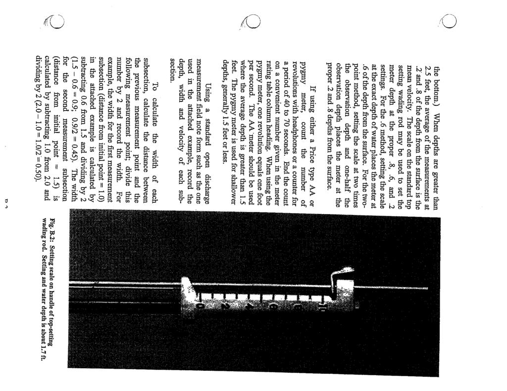
77
78
79
80

81
CHAPTER I INTRODUCTION TO WYOMING WATER ADMINISTRATION
 INTRODUCTION TO WYOMING WATER ADMINISTRATION Section 1. Constitutional Framework. a. The water within the boundaries of Wyoming is declared to be the property of the state by Section 1, Article 8 of the
Water Measurement. Presentation by. L. Niel Allen Extension Irrigation Specialist Utah State University
 Water Measurement Presentation by L. Niel Allen Extension Irrigation Specialist Utah State University to Utah State Engineer s Office Division of Water Rights Salt Lake City, Utah December 11, 2013 Introduction
Policy No As of January 12, 2016
 Policy No. 2016-1 As of January 12, 2016 Carbon Canal Company Supplemental Field Policies and Procedures Our goal is to do our best to deliver the irrigation water that each irrigator is entitled to use.
New Mexico WATER RIGHTS FACT SHEET. August 15, 2001
 New Mexico WATER RIGHTS FACT SHEET August 15, 2001 Water Rights System: New Mexico s water law is based on the doctrine of prior appropriation or "first in time - first in right. All waters in New Mexico
KATHY MROWKA STATE WATER RESOURCES CONTROL BOARD NOVEMBER, 2016
 KATHY MROWKA STATE WATER RESOURCES CONTROL BOARD NOVEMBER, 2016 Primary Components of the New Law Reporting Measurement Reporting Requirements Applies to all water rights Report once a year: Statements
K.A.R Water flowmeter specifications. (a) Each water flowmeter required by the chief engineer, or required pursuant to a regulation adopted
 Each water flowmeter required by the chief engineer, or required pursuant to a regulation adopted") K.A.R. 5-1-4. Water flowmeter specifications. (a) Each water flowmeter required by the chief engineer, or required pursuant to a regulation adopted by the chief engineer, on or after the effective date
K.A.R. 5-1-4. Water flowmeter specifications. (a) Each water flowmeter required by the chief engineer, or required pursuant to a regulation adopted by the chief engineer, on or after the effective date
ADMINISTRATION AND ENFORCEMENT OF THE COLORADO CHEMIGATION ACT
 DEPARTMENT OF AGRICULTURE Plant Industry Division ADMINISTRATION AND ENFORCEMENT OF THE COLORADO CHEMIGATION ACT 8 CCR 1203-8 [Editor s Notes follow the text of the rules at the end of this CCR Document.]
Horse Creek Public Hearing February 15, 2017, 2:00 PM
 Horse Creek Public Hearing February 15, 2017, 2:00 PM Introduction Brief History 2013 Order Results Precipitation Groundwater Diversions Surface Water Diversions Reservoir Stage Horse Creek Streamflow
Idaho Aquifer Sustainability Recharge: Interface of Quantity & Quality. John K. Simpson Western States Water Council Fall Workshop October 6, 2015
 Idaho Aquifer Sustainability Recharge: Interface of Quantity & Quality John K. Simpson Western States Water Council Fall Workshop October 6, 2015 Factors Effecting Declines in the ESPA Increase in GW
EID POLICY MANUAL. WATER Water Delivery and Operations Policy Revised January [supersedes May ]
![EID POLICY MANUAL. WATER Water Delivery and Operations Policy Revised January [supersedes May ]](/thumbs/81/82819723.jpg "EID POLICY MANUAL. WATER Water Delivery and Operations Policy Revised January [supersedes May ]") Policy Guidelines: 1.0 Irrigation of Properly Assessed Irrigation Land Water supplied for irrigation may only be delivered to lands that are properly assessed for irrigation purposes. The classification
Policy Guidelines: 1.0 Irrigation of Properly Assessed Irrigation Land Water supplied for irrigation may only be delivered to lands that are properly assessed for irrigation purposes. The classification
WinTR-55 Small Watershed Hydrology
 WinTR-55 Small Watershed Hydrology Intermediate WinTR-55 Training Modeling Watersheds with Structures SEE NOTES AT CLASS EXERCISE #4. 1 Course Outline Overview Review of Hydrology Terms Modeling Single
Colorado Water Law Basics and Grand Valley Water Rights. Kirsten M. Kurath Williams, Turner & Holmes, P.C.
 Colorado Water Law Basics and Grand Valley Water Rights Kirsten M. Kurath Williams, Turner & Holmes, P.C. www.wth-law.com Water Law Systems Riparian Landowners along a water body have the right to make
Irrigation Structures 2. Dr. M. R. Kabir
 CHAPTER 9 Irrigation Structures 2 Dr. M. R. Kabir Professor and Head, Department of Civil Engineering University of Asia Pacific (UAP), Dhaka LECTURE 22 What is Cross Drainage Works? In an irrigation project,
RULE 68. DISPOSAL OF NATURALLY OCCURRING RADIOACTIVE MATERIALS (NORM) ASSOCIATED WITH THE EXPLORATION AND PRODUCTION OF OIL AND GAS
 ASSOCIATED WITH THE EXPLORATION AND PRODUCTION OF OIL AND GAS") RULE 68. DISPOSAL OF NATURALLY OCCURRING RADIOACTIVE MATERIALS (NORM) ASSOCIATED WITH THE EXPLORATION AND PRODUCTION OF OIL AND GAS I. Definitions For the purposes of this Rule 1. Ambient Exposure Rate
RULE 68. DISPOSAL OF NATURALLY OCCURRING RADIOACTIVE MATERIALS (NORM) ASSOCIATED WITH THE EXPLORATION AND PRODUCTION OF OIL AND GAS I. Definitions For the purposes of this Rule 1. Ambient Exposure Rate
Nevada Water Law 101 Overview
 Nevada Water Law 101 Overview APPENDIX R Nevada s first water law was passed in 1866 and has been amended many times since then. Today, the law serves the people of Nevada by providing the rules for applying
Measurement of Stream Discharge. Using Weirs and Flumes
 Maine Geologic Facts and Localities March, 2012 Using Weirs and Flumes Text by Daniel B. Locke, Department of Agriculture, Conservation & Forestry 1 Introduction Hydrologists, hydrogeologists, engineers,
Technical Bulletin. Permit to Take Water Program Monitoring and Reporting of Water Takings. November 2006
 November 2006 Technical Bulletin Permit to Take Water Program Monitoring and Reporting of Water Takings This bulletin is to assist permit holders in understanding the monitoring and reporting requirements
Types of Hydropower Facilities
 Types of Hydropower Facilities 1 Impoundment Hydropower- uses a dam to store water. Water may be released either to meet changing electricity needs or to maintain a constant water level. 2 Run-of-River
Basic Design of Replogle Flumes
 ITRC Report No. R 02-010 IRRIGATION TRAINING AND RESEARCH CENTER California Polytechnic State University San Luis Obispo, California 93407 www.itrc.org Basic Design of Replogle Flumes Replogle flumes are
Order to Talk. Water Measurement Techniques, Water Price and Water Fee collection. 1 Water Measurement Techniques
 Training for YPs of Asia on Performance Assessment of Irrigation Systems Water Measurement Techniques, Water Price and Water Fee collection Ding Kunlun klding@iwhr.com Beijing, 11 April 2018 Order to Talk
DRAFT MEMORANDUM DATE:
 DRAFT MEMORANDUM DATE: June 30, 2014 TO: Mariel Platt, City of Hailey FROM: Scott King, P.E., Cathy Cooper, P.E. CC: Cole Balis, Brandon Lynch, Roxanne Brown, Eric Landsberg, P.E. RE: City of Hailey, Indian
Chapter CONSTRUCTION SITE EROSION CONTROL
 Chapter 19.30 CONSTRUCTION SITE EROSION CONTROL Sections: 19.30.010 When required. 19.30.020 Definitions. 19.30.030 Technical Standards 19.30.040 Erosion and sediment control performance standards for
Ponds. Pond A water impoundment made by excavating a pit, or constructing a dam or an embankment.
 POND SITE SELECTION AND CONSTRUCTION Uses, Planning, & Design David Krietemeyer Area Engineer USDA-NRCS June 20, 2008 Uses Considerations for Location of Commonly Used Terms Pond A water impoundment made
Nevada Water Law. Water Permits The application process To acquire a water permit, an application must be made on an approved form and filed
 Nevada Water Law An overview Nevada's first water statute was enacted in 1866 and has been amended many times since then. Today, the law serves the people of Nevada by managing the state's valuable water
Conservation through calibration and communication
 Water Resources Management V 65 Conservation through calibration and communication B. P. Tullis & S. L. Barfuss Utah State University, USA Abstract To effectively manage a water resource, one must be able
This is a digital document from the collections of the Wyoming Water Resources Data System (WRDS) Library.
 Library.") This is a digital document from the collections of the Wyoming Water Resources Data System (WRDS) Library. For additional information about this document and the document conversion process, please contact
This is a digital document from the collections of the Wyoming Water Resources Data System (WRDS) Library. For additional information about this document and the document conversion process, please contact
TENSION. Measuring Water Flow in Surface. (a) s h. (b) Irrigation Ditches and Gated Pipe. Units of Measuring Water. Edward C.
 s h. (b) Irrigation Ditches and Gated Pipe. Units of Measuring Water. Edward C.") E AZ1329 ARIZONA COOPERATIVE TENSION College of Agriculture and Life Sciences Revised 12/11 Measuring Water Flow in Surface Irrigation Ditches and Gated Pipe Edward C. Martin Arizona Water Series No.31
E AZ1329 ARIZONA COOPERATIVE TENSION College of Agriculture and Life Sciences Revised 12/11 Measuring Water Flow in Surface Irrigation Ditches and Gated Pipe Edward C. Martin Arizona Water Series No.31
Peerless Pump Company Handbook of Engineering Data
 Peerless Pump Company Handbook of Engineering Data Brochure EM77 DEFINITION OF PUMP TERMS A.1 A line shaft vertical turbine pump is a vertical-shaft centrifugal or mixed-flow pump with rotating impeller
Flow Measurement Structure Assessment
 Flow Measurement Structure Assessment Report prepared for the Richmond Irrigation District by Eric Leigh, Milton Henry, and Guy Fipps 1 June 2, 2003 Summary Extension Agricultural Engineering investigated
Design and Construction of Local Public and Private Sewers and Ancillary Facilities
 Chapter 2 Design and Construction of Local Public and Private Sewers and Ancillary Facilities Subchapter I - General 2.101 Purpose...1 2.102 Applicability...1 2.103 Electronic data...1 2.104 Effect of
Education. V. Know How to Maintain an Efficient Pump. Pump Efficiency Tests. What is a Pump Test? Who Does the Pump Testing?
 V. Know How to Maintain an Efficient Pump There are at least four important aspects of maintaining an efficient pumping plant: 1. Initial specification and installation of the pumping plant. 2. Ensuring
STORAGE BASIN AND PUMPING PLANT DESIGN (G 500)
") TABLE OF CONTENTS STORAGE BASIN AND PUMPING PLANT DESIGN (G 500) SECTION NO. SUBJECT DATE G 510 BASIC DESIGN DATA G 511 Types of Storage and Pumping Systems G 512 Extent of Design " G 513 Design Criteria
TABLE OF CONTENTS STORAGE BASIN AND PUMPING PLANT DESIGN (G 500) SECTION NO. SUBJECT DATE G 510 BASIC DESIGN DATA G 511 Types of Storage and Pumping Systems G 512 Extent of Design " G 513 Design Criteria
DROUGHT CONTINGENCY PLAN SUMMARY
 May 01, 2014 DROUGHT CONTINGENCY PLAN SUMMARY CANYON RESERVOIR Canyon Reservoir 8,200 surface acres -- Impounds 378,852 acre feet Conservation Pool Between 800 mean sea level (msl) and elevation of 909
CVEN 339 Summer 2009 Final Exam. 120 minutes allowed. 36 Students. No curve applied to grades. Median 70.6 Mean 68.7 Std. Dev High 88 Low 24.
 CVEN 339 Final Exam 120 minutes allowed 36 Students No curve applied to grades Median 70.6 Mean 68.7 Std. Dev. 13.7 High 88 Low 24.5 Name: CVEN 339 Water Resources Engineering Summer Semester 2009 Dr.
L.I WATER USE REGULATIONS, 2001 ARRANGEMENT OF REGULATIONS
 ARRANGEMENT OF REGULATIONS Regulation 1. Water use permit 2. Application procedure 3. Publications 4. Commission s decision 5. Investigations 6. Public hearing 7. Priority of water use 8. Objections 9.
Water Measurement Options in Low-Head Canals and Ditches
 Water Measurement Options in Low-Head Canals and Ditches by F. Jeffrey Peterson, P.E. Water Conservation Center Pacific Northwest Region Bureau of Reclamation Boise, Idaho September 2003 Measuring water
Irrigated Lands Mapping and Permit GIS Data
 TECHNICAL MEMORANDUM SUBJECT: PREPARED BY: Irrigated Lands Mapping and Permit GIS Data Robert E. King Sunrise Engineering, Inc. DATE: January 11, 2003 Introduction Irrigated agriculture represents the
INTEGRATED MANAGEMENT PLAN Jointly Developed by the North Platte Natural Resources District and the Nebraska Department of Natural Resources
 INTEGRATED MANAGEMENT PLAN Jointly Developed by the North Platte Natural Resources District and the Nebraska Department of Natural Resources CHAPTER 1: EFFECTIVE DATE This Integrated Management Plan (IMP)
United States Society on Dams (USSD)
") United States Society on Dams (USSD) Water Rights and Hydropower An Alaskan Perspective September 20, 2017 BILL WALKER, GOVERNOR DEPARTMENT OF NATURAL RESOURCES DIVISION OF MINING, LAND & WATER Water Resources
United States Society on Dams (USSD) Water Rights and Hydropower An Alaskan Perspective September 20, 2017 BILL WALKER, GOVERNOR DEPARTMENT OF NATURAL RESOURCES DIVISION OF MINING, LAND & WATER Water Resources
Florida Fish and Wildlife Conservation Commission (Division 68) Chapter 68F Aquatic Plants
 Chapter 68F Aquatic Plants") Florida Fish and Wildlife Conservation Commission (Division 68) Chapter 68F Aquatic Plants CHAPTER 68F-54 FUNDING FOR AQUATIC PLANT MANAGEMENT 68F-54.001 68F-54.003 68F-54.0035 68F-54.005 Program Criteria
Florida Fish and Wildlife Conservation Commission (Division 68) Chapter 68F Aquatic Plants CHAPTER 68F-54 FUNDING FOR AQUATIC PLANT MANAGEMENT 68F-54.001 68F-54.003 68F-54.0035 68F-54.005 Program Criteria
AN ORDINANCE OF THE COUNTY OF SAN BERNARDINO, STATE OF CALIFORNIA, ADDING ARTICLE 5 TO CHAPTER 6 OF DIVISION
 ORDINANCE NO. AN ORDINANCE OF THE COUNTY OF SAN BERNARDINO, STATE OF CALIFORNIA, ADDING ARTICLE TO CHAPTER OF DIVISION OF TITLE OF THE SAN BERNARDINO COUNTY CODE RELATING TO GROUNDWATER MANAGEMENT IN THE
DRAINAGE REPAIR POLICY FOR COUNTY DRAINAGE SYSTEMS. Drainage System No.
 DRAINAGE REPAIR POLICY FOR COUNTY DRAINAGE SYSTEMS Drainage System No. The following policy is intended to supplement Minnesota Statutes Chapter 103E in the Maintenance and Operation of Drainage Systems
MEMORANDUM. Date: October 2, 2013 To: Public Works Commission From: Paul Woods, Environmental Division Manager Subject: Water Resources Update
 MEMORANDUM Date: October, 0 To: Public Works Commission From: Paul Woods, Environmental Division Manager Subject: Water Resources Update Goal: Develop phased implementation plan of Water Resources Advisory
This is a digital document from the collections of the Wyoming Water Resources Data System (WRDS) Library.
 Library.") This is a digital document from the collections of the Wyoming Water Resources Data System (WRDS) Library. For additional information about this document and the document conversion process, please contact
This is a digital document from the collections of the Wyoming Water Resources Data System (WRDS) Library. For additional information about this document and the document conversion process, please contact
Chapter NONPOTABLE WATER DISTRIBUTION SYSTEM
 13.05.010 Chapter 13.05 NONPOTABLE WATER DISTRIBUTION SYSTEM Sections: 13.05.010 Findings, purpose and intent. 13.05.020 Nonpotable water policy. 13.05.030 Definitions. 13.05.040 Administration. 13.05.050
Flow Measurement for Structure Assessment in Richmond Irrigation District
 COLLEGE OF AGRICULTURE AND LIFE SCIENCES TR-379 2011 Flow Measurement for Structure Assessment in Richmond Irrigation District By: Eric Leigh, Extension Associate; Milton Henry, Graduate Assistant; and
Project Information. Pursuant to Section 404 of the Clean Water Act (33 U.S. Code 1344), notice is hereby given that
, notice is hereby given that") US ARMY Corps Of Engineers Little Rock District JOINT PUBLIC NOTICE CORPS OF ENGINEERS STATE OF MISSOURI Application Number: SWL 2013-00260 Date: April 15, 2014 Comments Due: May 6, 2014 TO WHOM IT MAY
US ARMY Corps Of Engineers Little Rock District JOINT PUBLIC NOTICE CORPS OF ENGINEERS STATE OF MISSOURI Application Number: SWL 2013-00260 Date: April 15, 2014 Comments Due: May 6, 2014 TO WHOM IT MAY
EXISTING EID WATER SUPPLY SOURCES
 EXISTING EID WATER SUPPLY SOURCES FOLSOM RESERVOIR Folsom Reservoir is located at the west end of El Dorado County, at the confluence of the North and South Forks of the American River. EID treats water
Title 15 BUILDINGS AND CONSTRUCTION
 Title 15 BUILDINGS AND CONSTRUCTION Chapters: 15.04 International Codes Adopted 15.08 Building Permits 15.12 Movement of Buildings Chapter 15.04 INTERNATIONAL CODE COMMISSION CODES Sections: 15.04.010
Water Management in Idaho. 188 th Meeting, Western States Water Council October 25 th 26th, 2018 Coeur d Alene, Idaho
 Water Management in Idaho 188 th Meeting, Western States Water Council October 25 th 26th, 2018 Coeur d Alene, Idaho Presentation Overview 1. Welcome 2. Introduction to Idaho 3. Introduction to the IDWR
SOUTH FORK AMERICAN RIVER (CHILI BAR), CALIFORNIA
, CALIFORNIA") Hydropower Project Summary SOUTH FORK AMERICAN RIVER (CHILI BAR), CALIFORNIA CHILI BAR HYDROELECTRIC PROJECT (P-2155) Photo Credit: PG&E This summary was produced by the Hydropower Reform Coalition and
Hydropower Project Summary SOUTH FORK AMERICAN RIVER (CHILI BAR), CALIFORNIA CHILI BAR HYDROELECTRIC PROJECT (P-2155) Photo Credit: PG&E This summary was produced by the Hydropower Reform Coalition and
TECHNICAL MEMORANDUM Summerhill Rd Texarkana, Texas fax
 TECHNICAL MEMORANDUM 5930 Summerhill Rd Texarkana, Texas 75503 903 838 8533 fax 903 832 4700 TO: Becky Griffith, Jon Jarvis FROM Spandana Tummuri SUBJECT: Technical Memorandum on IP Analysis PROJECT: Sulphur
Lagoon Pumping and Irrigating Equipment
 University of Missouri Extension G117, Reviewed October 1993 Lagoon Pumping and Irrigating Equipment Charles D. Fulhage Department of Agricultural Engineering Lagoons are an important part of many Missouri
Basics of Colorado Water Law. February, 2019 Rob Pierce
 Basics of Colorado Water Law February, 2019 Rob Pierce Public Ownership: Article XVI 5 of Colorado Constitution says that water is the property of the public Priority Administration First to file, first
Concepts of Ground Water Recharge and Well Augmentation in Northeastern Colorado. Stephen W. Smith 1 Rachel J. Barta 2 Donald O. Magnuson 3 ABSTRACT
 Concepts of Ground Water Recharge and Well Augmentation in Northeastern Colorado Stephen W. Smith 1 Rachel J. Barta 2 Donald O. Magnuson 3 ABSTRACT In northeastern Colorado, severe drought plus recent
MCLEOD COUNTY JOINT DRAINAGE SYSTEM POLICY AND GUEIDELINES FOR REPAIR
 MCLEOD COUNTY JOINT DRAINAGE SYSTEM POLICY AND GUEIDELINES FOR REPAIR MEEKER, DISTRICTS 3, 4 and 5 OF MCLEOD, RENVILLE AND SIBLEY COUNTIES The following policy is intended to supplement Minnesota Statutes
Conservation, Efficiency, and Markets: Improve Water Management and Use Market-Based Approaches To Head off Conflicts
 1 In many cases, implementation of new water conservation and efficiency improvements through cooperative partnerships will result in an increased ability to meet otherwise conflicting demands for water.
NC General Statutes - Chapter 160A Article 25 1
 Article 25. Public Transportation Authorities. 160A-575. Title. This Article shall be known and may be cited as the "North Carolina Public Transportation Authorities Act." (1977, c. 465; 1979, 2nd Sess.,
U. S. FOREST SERVICE RESEARCH NOTE NE-29
 U. S. FOREST SERVICE RESEARCH NOTE NE-29 1965 ACCURACY IN STREAMFLOW MEASUREMENTS ON THE FERNOW EXPERIMENTAL FOREST Measurement of streamflow from small watersheds on the Fernow Experimental Forest at
INSTRUCTIONS FOR FILING A LONG FORM WASTEWATER TREATMENT SURCHARGE STATEMENT
 COUNTY SANITATION DISTRICTS OF LOS ANGELES COUNTY Grace Robinson Hyde, Chief Engineer and General Manager INSTRUCTIONS FOR FILING A LONG FORM WASTEWATER TREATMENT SURCHARGE STATEMENT TABLE OF CONTENTS
Asst.Prof.Dr. Jaafar S. Maatooq. 1 st Semester HYDRAULIC STRUCTUER, KINDS & FUNCTIONS 1 of 26
 1 st Semester HYDRAULIC STRUCTUER, KINDS & FUNCTIONS 1 of 26 1 st Semester HYDRAULIC STRUCTUER, KINDS & FUNCTIONS 2 of 26 Water is often more useful to people when it is properly controlled, conveyed,
EO = IHP= The efficiency of a pumping plant is calculated as follows:
 The efficiency of a pumping plant is calculated as follows: EO = QxH 3,960 x IHP where Eo is the overall pumping efficiency, Q is the pump flow rate or capacity (gallons per minute [gpm]), H is total head
BE IT ORDAINED by the Borough Council of the Borough of Mountain Lakes, in the County of Morris and State of New Jersey, as follows:
 BOROUGH OF MOUNTAIN LAKES MORRIS COUNTY, NEW JERSEY ORDINANCE 10-16 ORDINANCE AMENDING CHAPTERS 245 AND 102 OF THE REVISED GENERAL ORDINANCES OF THE BOROUGH OF MOUNTAIN LAKES AND PROVIDING LAND USE REGULATIONS
Application for Gas Exploration and Production
 1800 Washington Blvd. Suite 655 Baltimore Maryland 21230 Application for Gas Exploration and Production This application is to be used to obtain a permit to Drill and Operate a well, within the State for
Sump Pumps Office procedures for the Drainage & Grading section
 County of Los Angeles Department of Public Works Building and Safety Division Grading and Drainage Section Sump Pumps Office procedures for the Drainage & Grading section Introduction This manual provides
INTEGRATED MANAGEMENT PLAN Jointly Developed by the Central Platte Natural Resources District and the Nebraska Department of Natural Resources
 INTEGRATED MANAGEMENT PLAN Jointly Developed by the Central Platte Natural Resources District and the Nebraska Department of Natural Resources CHAPTER 1: EFFECTIVE DATE I. This Integrated Management Plan
Permit for Construction of an Extension to a JEA Drinking Water Distribution System and/or JEA Wastewater Collection/Transmission System
 Permit for Construction of an Extension to a JEA Drinking Water Distribution System and/or JEA Wastewater Collection/Transmission System INSTRUCTIONS: This form shall be completed and submitted (in duplicate)
Methods of Streamflow Analysis
 4 Methods of Streamflow Analysis CHAPTER 4 Streamflow Measurements Danielle M. Andrews Department of Crop and Soil Sciences, The Pennsylvania State University I. INTRODUCTION Perennial carries water all
Development of Stage-Discharge Ratings for Site 2240 Bear Creek at Cold Spring
 Development of Stage-Discharge Ratings for Site 2240 Bear Creek at Cold Spring Prepared for: Urban Drainage and Flood Control District 2480 W. 26 th Avenue Suite 156-B Denver, CO 80211 May 19, 2006 (Rev
4. Present Activities and Roles
 4. Present Activities and Roles The present missions, authorities, activities and roles of the various agencies involved with flood protection, floodplain management and flood-damage reduction are identified
Engineering and Hydrologic Issues in Changing Water Uses
 University of Colorado Law School Colorado Law Scholarly Commons Colorado Water Issues and Options: The 90's and Beyond: Toward Maximum Beneficial Use of Colorado's Water Resources (October 8) Getches-Wilkinson
SENATE, No STATE OF NEW JERSEY. 210th LEGISLATURE INTRODUCED MAY 13, 2002
 SENATE, No. STATE OF NEW JERSEY 0th LEGISLATURE INTRODUCED MAY, 00 Sponsored by: Senator BOB SMITH District (Middlesex and Somerset) SYNOPSIS Requires DEP to develop Site Master Plan for Six Mile Run Reservoir
Aurora Water Pursues New Water Source Water rights purchase provides environmental benefits
 NEWS RELEASE FOR IMMEDIATE RELEASE January 22, 2018 Contact: Greg Baker Manager of Aurora Water Public Relations 303.739.7081 office 720.278.1299 cell gbaker@auroragov.org Aurora Water Pursues New Water
Seepage Losses for the Rio Grande Project (Franklin Canal Case Study)
") Seepage Losses for the Rio Grande Project (Franklin Canal Case Study) Zhuping Sheng, Ph.D., P.E. Yaqi Wanyan, M.S., EIT Luis S. Aristizabal Kadambari Reddy, M.S., EIT TAMU, Agricultural Research and Extension
Seepage Losses for the Rio Grande Project (Franklin Canal Case Study) Zhuping Sheng, Ph.D., P.E. Yaqi Wanyan, M.S., EIT Luis S. Aristizabal Kadambari Reddy, M.S., EIT TAMU, Agricultural Research and Extension
IC ARTICLE 13. PROBATION AND PAROLE
 IC 11-13 ARTICLE 13. PROBATION AND PAROLE IC 11-13-1 Chapter 1. Probation Administration IC 11-13-1-1 Probation officers; appointment; qualifications; term, responsibility, salaries, expenses, bond Sec.
Hydrologic Characteristics of the Owens River Basin below the Upper Owens River
 Appendix T. Hydrologic Characteristics of the Owens River Basin below the Upper Owens River The hydrology of Mono Basin is described in detail in Chapter 3A. This appendix describes the Owens River basin
FELT, MONSON & CULICHIA, LLC Attorneys at Law 319 North Weber Street, Colorado Springs, CO 80903
 James G. Felt FELT, MONSON & CULICHIA, LLC Attorneys at Law 319 North Weber Street, Colorado Springs, CO 80903 Email: iwc@fmcwater.com Steven T. Monson Telephone: 719-471 -1212 James W. Culichia Fax: 719-471
Agricultural Pumping Efficiency Program. Flow Meters. Helping California Agriculture...
 Agricultural Pumping Efficiency Program Flow Meters Helping California Agriculture... Flow Meters The Agricultural Pumping Efficiency Program is providing this information regarding the importance of measuring
today and offer the Department's views on S a measure to authorize tae construction of the Cibolo Project. The 'feasibility report has
 Statement of Commissioner Gilbert G. Stamm; Bureau of Reclamation; witness for the Department of the Interior before the Subcommittee on Water and Power Resources, Senate Committee on Interior and Insular
Chapter 8. Editor. Ted W. van der Gulik, P.Eng. Authors. Stephanie Tam, B.A.Sc. T. Janine Nyvall, P.Eng. Lance Brown, Eng Tech.
 B.C. IRRIGATION MANAGEMENT GUIDE Chapter 8 Editor Ted W. van der Gulik, P.Eng. Authors Stephanie Tam, B.A.Sc. T. Janine Nyvall, P.Eng. Lance Brown, Eng Tech Prepared by B.C. Ministry of Agriculture, Food
Guidelines for water meter installation Looking after all our water needs
 Guidelines for water meter installation 2009 Looking after all our water needs Department of Water Report no. 2 July 2009 Department of Water 168 St Georges Terrace Perth Western Australia 6000 Telephone
This is a digital document from the collections of the Wyoming Water Resources Data System (WRDS) Library.
 Library.") This is a digital document from the collections of the Wyoming Water Resources Data System (WRDS) Library. For additional information about this document and the document conversion process, please contact
This is a digital document from the collections of the Wyoming Water Resources Data System (WRDS) Library. For additional information about this document and the document conversion process, please contact
PCCD Groundwater Rules Overview
 PCCD Groundwater Rules Overview This Overview is a summary of the PCCD Rules on types of groundwater wells. It is intended for use by an individual who seeks authority to produce water for use by the individual
Laramie County Control Area Groundwater Management Plan
 Laramie County Control Area Groundwater Management Plan Laramie County Control Area Steering Committee Report to the Laramie County Board of Commissioners March 2016 Contents Laramie County Control Area
(B) "Facility," for the purposes of this rule, means:
 Facility, for the purposes of this rule, means:") 3745-27-13 Procedure to engage in filling, grading, excavating, building, drilling, or mining on land where a hazardous waste facility or solid waste facility was operated. (A) No person shall, without
3745-27-13 Procedure to engage in filling, grading, excavating, building, drilling, or mining on land where a hazardous waste facility or solid waste facility was operated. (A) No person shall, without
INYANGA RANCH Garfield County, Colorado
 INYANGA RANCH Garfield County, Colorado Summary of Water and Mineral Rights September 22, 2017 Inyanga Ranch (the Ranch ) is comprised of approximately 528.61 acres located within the Canyon Creek drainage
Stream Reaches and Hydrologic Units
 Chapter United States 6 Department of Agriculture Natural Resources Conservation Service Chapter 6 Stream Reaches and Hydrologic Units Rain clouds Cloud formation Precipitation Surface runoff Evaporation
UNIFORM DESIGN AND CONSTRUCTION STANDARDS FOR EXTENDING WATER DISTRIBUTION SYSTEMS SECTION 2 DESIGN STANDARDS
 UNIFORM DESIGN AND CONSTRUCTION STANDARDS FOR EXTENDING WATER DISTRIBUTION SYSTEMS SECTION 2 DESIGN STANDARDS DESIGN STANDARDS SECTION 2 INDEX ITEM DESCRIPTION 2.00 GENERAL STATEMENT 2.01 WATER DISTRIBUTION
Wastewater ENVIRONMENTAL SETTING. Wastewater Collection
 4.15.3.1 ENVIRONMENTAL SETTING Wastewater Collection The City owns, operates, and maintains the local sewer lines that collect wastewater generated within the City. The existing sewer lines include a gravity
MINNEHAHA CREEK WATERSHED DISTRICT BOARD OF MANAGERS REVISIONS PURSUANT TO MINNESOTA STATUTES 103D.341. Adopted April 24, 2014 Effective June 6, 2014
 MINNEHAHA CREEK WATERSHED DISTRICT BOARD OF MANAGERS REVISIONS PURSUANT TO MINNESOTA STATUTES 103D.341 Adopted April 24, 2014 Effective June 6, 2014 EROSION CONTROL RULE 1. POLICY. It is the policy of
DISTRICT COURT, WATER DIVISION 3, STATE OF COLORADO TO: ALL PERSONS INTERESTED IN WATER APPLICATIONS FILED IN WATER DIVISION 3.
 DISTRICT COURT, WATER DIVISION 3, STATE OF COLORADO TO: ALL PERSONS INTERESTED IN WATER APPLICATIONS FILED IN WATER DIVISION 3. Pursuant to C.R.S. 37-92-302(3), you are notified that the following is a
ZONING ORDINANCE FOR THE ZONED UNINCORPORATED AREAS ARTICLE 1500 OF PUTNAM COUNTY, WEST VIRGINIA Page 149 ARTICLE 1500 DRAINAGE AND STORM SEWERS
 OF PUTNAM COUNTY, WEST VIRGINIA Page 149 ARTICLE 1500 DRAINAGE AND STORM SEWERS 1500.01 GENERAL REQUIREMENTS 1500.02 NATURE OF STORM WATER FACILITIES 1500.03 DRAINAGE EASEMENTS 1500.04 STORM WATER MANAGEMENT
J. Wetstein and V. Hasfurther Conference Proceedings WWRC
 RESPONSE OF A SURFACE AQUIFER TO FLOOD IRRIGATION J. Wetstein and V. Hasfurther 1989 Conference Proceedings WWRC- 8 9-32 In Proceedings of the Specialty Conference Sponsored by the Irrigation and Drainage
If you have any questions on the OCMP, please do not hesitate to contact me at (425) or Keith Binkley at (425)
 or Keith Binkley at (425)") SNOHOMISH COUNTY PUBLIC UTILITY DISTRICT NO.1 Providing quality water, power and service at a competitive price that our customers value December 15, 2011 VIA ELECTRONIC FILING Kimberly D. Bose, Secretary
SNOHOMISH COUNTY PUBLIC UTILITY DISTRICT NO.1 Providing quality water, power and service at a competitive price that our customers value December 15, 2011 VIA ELECTRONIC FILING Kimberly D. Bose, Secretary
First ask the question: What is mine water management and why do we care?
 The Plan First ask the question: What is mine water management and why do we care? Then take a look at: The need for data Types of inflow to an underground mine Challenges to measuring inflow Methods application
TECHNICAL MEMORANDUM
 04/21/01 page 1 TECHNICAL MEMORANDUM SUBJECT: Green River Basin Plan Colorado River Basin Salinity Control Program PREPARED BY: Pat Tyrrell, States West Water Resources Corporation Introduction Water in
Securing and Protecting Water Rights and Uses in Arizona
 Securing and Protecting Water Rights and Uses in Arizona L. William Staudenmaier One Arizona Center 400 East Van Buren Street, Suite 1900 Phoenix, Arizona 85004 2202 602.382.6000 602.382 6070 (fax) www.swlaw.com
Glossary Irrigation Terminology
 Glossary Irrigation Terminology ANGLE VALVE A valve configured so its outlet is oriented 90 from its inlet. In irrigation, these valves are generally installed with the inlet at the bottom of the valve.
Raw water sources, facilities, and infrastructure
 WATER AND WASTEWATER SERVICES IN STEAMBOAT SPRINGS Prepared by Jay Gallagher, General Manager Mt. Werner Water and Sanitation District (February, 2015) Raw water sources, facilities, and infrastructure
1 Exam Prep Chapter 64E -6 Questions and Answers
 1 Exam Prep Chapter 64E -6 Questions and Answers Part One 1. According to Florida Rules: Chapter 64E-6, if building construction has commenced, for how many additional days past the eighteen month expiration