Sustainable Halton. Aggregate Resources Strategy
|
|
|
- Logan Gordon
- 5 years ago
- Views:
Transcription

1 Sustainable Halton Aggregate Resources Strategy November 2007
2 TABLE OF CONTENTS EXECUTIVE SUMMARY i INTRODUCTION... 1 SECTION 1 STATE OF THE RESOURCE IN HALTON LOCATION OF THE RESOURCE RESOURCE EXTRACTION IN HALTON CONSTRAINTS TO RESOURCE EXTRACTION IN HALTON INTRODUCTION THE PROVINCIAL POLICY STATEMENT THE GREENBELT PLAN NIAGARA ESCARPMENT PLAN THE AGGREGATE RESOURCES ACT THE PLANNING ACT HALTON REGION OFFICIAL PLAN SECTION 3 POLICY OPTIONS FOR SHALE IN THE PRIMARY STUDY AREA ANALYSIS OPTIONS CONCLUSIONS SECTION 4 LAND USE POLICY APPROACHES IN THE REGION RESOURCE AREA MAPPING IN THE REGIONAL OFFICIAL PLAN (ROP) RESOURCE EXTRACTION POLICY IN THE GREENBELT RESOURCE EXTRACTION POLICY IN THE NIAGARA ESCARPMENT AREA AGGREGATE-RELATED TRANSPORTATION POLICY OPTIONS IN THE ROP POLICY OPTIONS FOR NET GAIN IN THE ROP POLICY OPTIONS FOR MAXIMUM DISTURBED AREA IN THE ROP POLICY OPTIONS FOR MONITORING IN THE ROP POLICY OPTIONS FOR ACCESSORY USES IN LICENSED AREAS POLICY OPTIONS FOR CONSERVATION AND RECYCLING... 75
3 TABLES Table 1 Amount of Resource Area in Halton...6 Table 2 Queenston Shale Locations and Descriptions...7 Table 3 Existing Licensed and Proposed Extraction Facilities in Halton...9 Table 4 Aggregate Product Description, Uses and Extraction Methods...11 Table 5 Aggregate Resource Extraction in the GTA MNR District and Ontario by Type as a Percent of Total Aggregate Extracted...12 Table 6 Upper Tier Municipalities in the Vicinity of Halton: Production from 2002 to 2005 (Millions of Tonnes)...13 Table 7 License Revenues in Halton 2000 to Table 8 Primary Constraints (ha.)...15 Table 9 Secondary Constraint Areas (ha.)...16 Table 10 Summary of Primary and Secondary Constraint Areas...17 MAPS - Map 1 Resource Areas in Halton Map 2 Queenston Formation and Shale Resources Map 3a Shale Resources in Halton 2006 Map 3b Shale Resources in Halton 2007 Map 3c Shale Resources in Halton 1996, 2006, and 2007 Map 4 Location of Licensed Areas Map 5 Primary Constraints Map 6 Secondary Constraints Map 7 Primary and Secondary Constraints Maps 8A to 8E Constraints on Shale Resources APPENDICES Appendices 1A to 1F Primary Constraints Appendices 2A to 2F Secondary Constraints
4 The overall intent of the strategy is to: EXECUTIVE SUMMARY Make specific recommendations on what policy approach should be adopted for the shale deposits located in the Primary Study Area (outside of the Greenbelt); Identify land use policy options for the protection of resource areas and the extraction of aggregate on a Region-wide basis while minimizing land use conflicts; Identify a role for Best Practices in the Region s Strategy, including resource conservation and rehabilitation; and, Recommend changes to the Regional Official Plan (ROP) to ensure conformity with the Provincial Growth Plan, Greenbelt Plan and Provincial Policy Statement (PPS 2005) with respect to aggregate resources. The development of the strategy will occur in two phases. The intent of the first phase is to provide an overview of applicable Provincial policy and the state of the resource in the Region and to develop four policy options with respect to the shale resources in the Primary Study Area. In addition, some of the Region wide ROP policy issues to be dealt with as part of the Official Plan Review are discussed. The intent of this discussion is to identify potential options on: how the social and environmental impacts of resource use could be assessed during the application review stage and then minimized as appropriate through conditions of approval; how the impacts of resource use on the road network could be assessed and how improvements to the road network will be funded as appropriate; how potential resource areas could be mapped and designated in the ROP; how net gain of features and functions could be assessed and then implemented; recycling and conservation and potential roles for the Region in minimizing the amount of aggregate required; how conditions of approval could be implemented and monitored in the long term; and, how Best Practices could be included in the assessment criteria and then implemented through conditions for approval. The intent of the second phase is to build upon the work completed in the first phase and make a number of recommendations on new ROP policy that is consistent with the new PPS, conforms to the Greenbelt Plan and also reflects Regional priorities. The current application process for new or expanding resource uses in the Region of Halton requires an investment of several years and significant resources for detailed technical studies, with most applications ending up at the Ontario Municipal Board (OMB). The development of a new aggregate resources strategy provides the Region with an opportunity to improve the current state of affairs by being much more proactive on what the Region s expectations are in terms of where extraction is anticipated to occur in the future and under what conditions. In addition, an opportunity exists for the Region to take the lead on policy approaches to minimize social and environmental impacts that reflect Regional objectives. It is hoped that the end result will be more surety for the industry and the public when making property investment decisions, reduce conflict and the time and resources required to process individual applications. With respect to shale resources, new mapping released by the Province in the Summer of 2007 indicates that potentially viable shale resource extraction areas are located north of Highway 401 in Halton Hills and in Milton. At the present time, shale is required by the clay brick industry for EXECUTIVE SUMMARY November 29, 2007 i
5 the production of bricks for the construction industry. While there is no requirement in the Ontario Building Code for bricks in new construction, most new homes are clad in brick and it has become the standard for new home construction in southern Ontario. On this basis, while there is value in protecting shale resource areas for future extraction, it s relative value when compared to sand, gravel and crushed stone resources is less, since these latter materials are required for infrastructure (60% for roads) and there is an overall public interest in ensuring that the raw materials required for necessary infrastructure are available. At the present time, the only other shale resource areas in the GTA are in Brampton (but only for 10 years) and in Caledon (in the Niagara Escarpment Area near Cheltenham). If the Brampton lands are discounted, the only shale resource areas in the GTA that remain are in Caledon and Halton. The shale deposits in Caledon and Halton would supply hundreds of millions of tonnes of shale if the subject lands were licensed for extraction. Based on past trends and an expectation that historical demand will not significantly increase in the future (2 million tonnes per year), this amount of land would supply the clay brick industry for a few hundred years if all of the land was utilized. This supply analysis does not take the supply of shale in existing licensed areas or proposed licensed areas (such as the Tansley quarry in Burlington) into account. It is further noted that shale resource areas are also located outside of the GTA. Given the number of years of supply involved, a key consideration in making a decision on whether any or all of the shale resource areas identified in Halton should be protected is whether there is an overall public interest in protecting an area for future extraction in Halton in a circumstance where the combined area of the deposits would supply enough shale for the clay products industry for many hundreds of years. Other key considerations include the relative value of shale for infrastructure, the location of other shale deposits in the area and the policy framework in the Niagara Escarpment Plan and Greenbelt Plan that prohibits urban development in the shale resource area in Caledon. The last consideration is the impact of locating resource areas and related brick-making production facilities outside of the GTA instead of in Halton on transportation costs. The environmental impacts of transporting shale and/or finished brick from longer distances to the GTA market also need to be considered. On the basis of the above, below are the distinct options available to the Region of Halton with respect to the identified shale resources in the Region: A. Protect all of the resource area from incompatible development by placing the entirety of the identified shale resource area within a designation that provides for future extraction and which prevents the development of urban land uses. B. Protect a portion of the identified shale resource area, following the completion of a detailed review of which areas are the most viable for extraction, from a land use and quality perspective. C. Consider the resource areas identified by the Province in 2007 as not being significant. D. Retain only those resource areas that are within the permanent agricultural system, Natural Heritage System or Rural system in the Primary Study Area, but only as a consequence of these lands being identified for non-urban use. EXECUTIVE SUMMARY November 29, 2007 ii
6 NOTWITHSTANDING WHATEVER OPTION IS ULTIMATELY SELECTED, IF IT IS DETERMINED AS PART OF THE CURRENT PROCESS THAT NEW URBAN AREAS SHOULD BE LOCATED WHERE AN IDENTIFIED SHALE RESOURCE AREA IS LOCATED, RESOURCE EXTRACTION COULD BE PERMITTED WITHIN ANY NEW URBAN AREA AS AN INTERIM USE, SUBJECT TO CERTAIN CONDITIONS THAT ARE PRIMARILY RELATED TO DEPTH OF EXTRACTION. EXECUTIVE SUMMARY iii November 29, 2007
7 INTRODUCTION INTENT OF STRATEGY In accordance with the Growth Plan, municipalities have three years to implement the Growth Plan in their planning documents. It is on this basis that the Region of Halton has embarked on the Sustainable Halton planning process (SHP). The primary objective of the SHP is to determine how population and employment will be allocated to the four lower tier municipalities in the Region. A further objective of the SHP is to identify and protect those features and resources which are an integral component of the Region (environmental and agricultural lands) and/or which are required in the future to support growth (aggregates). It is in this context that a number of studies are being carried out to help shape what Halton will look like in 25 years and beyond. All of these studies will result in changes to the policies within the Region of Halton Official Plan (ROP). Changes to local Official Plans (Burlington, Oakville, Milton and Halton Hills) will also be required following the completion of the ROP update process. The development of an aggregate resource strategy for the Region has long been considered a priority. Given that the Growth Plan anticipates considerable population and employment growth in the Greater Toronto Area (GTA) to 2031 and beyond, there is an expectation on the part of the Province that the mineral aggregate resources required (some of which are in the Region) to support that growth and required infrastructure will be available at a reasonable cost. However, there is also a need for an Ontario strategy as well. According to Environmental Commissioner of Ontario reports, such a Provincial strategy has been under development since 2001 (ECO annual reports 2001 to 2005). However, no such strategy has been produced and it was reported in November 2007 that the Ministry of Natural Resources has decided to update the 1992 State of Resource Study beginning in January About 174 million tonnes of aggregate was extracted in Ontario in The following comments are made on the aggregate industry in the 2005 Ontario Aggregate Resources Corporation Report (TOARC): aggregates literally provide the basis for a $37 billion construction industry that employs over 270,000 people in Ontario. The aggregate industry employs an estimated 7,000 people directly and some 34,000 people indirectly in services such as transportation and equipment. The aggregate industry also makes a significant contribution to the $1.9 billion cement and concrete manufacturing industry, the $1.3 billion glass and glass products industry, and a $2.9 billion pharmaceutical and medicine manufacturing industry in Ontario. Aggregates are used in many forms of construction. It is used in the foundations and walls of homes, schools and offices. Aggregates are also used in the construction of most of Ontario s transportation infrastructure, including roads, highways, and bridges. It has been estimated that 60% of the aggregates consumed go into various forms of road construction (ECO report 2005). Sand and gravel production accounted for 56% of the aggregate extracted in Ontario in 2005, while crushed stone accounted for 42% and clay and shale production combined with building and dimension stone production accounted for the remainder. Mineral aggregate resources vary in quality and significance and cannot be found everywhere. Some areas have abundant Aggregate Resource Management in the Region of Halton 1
8 resources, while others have little or none. As a result, demand varies depending on the location and local, regional and Provincial requirements. It is noted that the Province has an interest in ensuring that the resources required for infrastructure and development are available and it is for this reason that the 2005 Provincial Policy Statement indicates that "as much of the mineral aggregate resources as is realistically possible shall be made available as close to markets as possible." While aggregates are an important part of the Ontario economy, the very nature of aggregate extraction, which typically requires the stripping of vegetation over large land areas and the excavating of sometimes deep holes in the ground, has had an impact on the public acceptability of the use. Issues that have been raised generally revolve around the environmental and hydrogeological impacts of extraction. Other issues raised include visual impact, impact on rural character, noise, dust and the impacts of transporting aggregate to market along haul routes. As a result of these general concerns, many applications for new or expanding resource uses ends up at the Ontario Municipal Board (OMB). The top aggregate producing municipalities in Ontario are in or close to fast growing urban centres such as the GTA. The State of the Resource Study (1992) indicated that from 1986 to 1990, the GTA had an average demand for 65 million tonnes, of which about 28 million tonnes was imported from outside the GTA. This same study indicated that imported aggregate for the GTA comes from Flamborough, Puslinch, Dufferin County, Simcoe County and from East of Durham Region (Victoria County now City of Kawartha Lakes). The demand for aggregate in the GTA was again indicated to be about 60 million tonnes in 2004 (Clayton Research presentation to the Aggregate Producers of Ontario 2004). About 31 million tonnes of this amount was extracted in the Regions of Halton, Peel, York and Durham in 2004, which translates into about 50% of the demand. In April 2007, it was again estimated that the GTA will consume 60 million tonnes of aggregate per year, which is about one-third of Ontario's total aggregate production (Ontario Stone, Sand and Gravel Association, State of the Resource (Region of Halton) April 2007). It has been noted by the Ontario Stone, Sand and Gravel Association (OSSGA), known formerly as the Aggregate Producers Association of Ontario (APAO), that the Region of Halton's "licensed aggregate supply is at a critical low" (OSSGA) April 2007). It has been further estimated by the OSSGA that the 12 mineral aggregate operations (18 licenses) supplying both crushed stone and sand and gravel in Halton "will be depleted within the next few years and all but one of the crushed stone quarries will be depleted within five years. The recently expanded Milton quarry would be the only main source of aggregate in Halton and if it tried to maintain Halton's historic production levels, it would be depleted by 2015". (OSSGA April 2007). It is on this basis that the OSSGA is of the view that new sources of aggregate will be required "as close to market as possible to support continued development in the Region of Halton. With respect to the amount produced in Halton, the 27 license holders in the Region of Halton produced an average of 11.2 million tonnes of aggregate per year between 2002 and 2005, which translates into 6.4% of the total extracted in that same time period in the Province (TOARC). It has recently been estimated that 2006 production has declined to 9.6 million tonnes. One of the reasons for the decline is the reduced supply in Halton, according to the industry. Aggregate Resource Management in the Region of Halton 2
9 Given the historic demand for aggregate (174 million tonnes in 2005) and given that population and employment growth will continue in southern Ontario, it is estimated that the demand for aggregate will at least be sustained at current levels, or even increase, as the Environmental Commissioner has indicated, by 2% per year. While there may be new conservation and recycling measures introduced in the future, these measures may not have a measurable impact on the demand for aggregate in the short and medium terms. The amount of land area under license in Halton in 2006 was about 2,050 hectares. An additional 38,000 hectares is potentially the site of a resource (ARIP 1996). However, based on our review of constraints, only 7,600 hectares of this amount (20%) is not subject to known constraints. It is noted that while 7,600 hectares are not subject to a primary or secondary constraint, much of this land area may be unavailable for resource use if the lands cannot be purchased, or if the assembly of multiple properties is required. In addition, some of these lands may not be accessible if they are separated from public roads by areas that are subject to a primary or secondary constraint or other properties that may not be available for purchase or lease. While most of the resource areas in the Region of Halton are located in the Greenbelt (which includes lands within the Niagara Escarpment Area), there are also shale resource areas identified in the Primary Study Area in south Georgetown and in Milton. Given that the shale resource areas are located outside of the Greenbelt Plan area, making a determination on how these areas will considered from a policy perspective is required early in the planning process, since these same lands may also be required for urban development. The current application process for new or expanding resource uses in the Region of Halton requires an investment of several years and significant resources for detailed technical studies. The development of a new aggregate resources strategy provides the Region with an opportunity to improve the current state of affairs by being much more proactive on what the Region s expectations are in terms of where extraction is anticipated to occur in the future and under what conditions. In addition, an opportunity exists for the Region to take the lead on policy approaches to minimize social and environmental impacts that reflect Regional priorities. It is hoped that the end result will be more surety for the industry and the public to inform property investment decisions, reduce conflict and reduce the time and resources required to process individual applications. All policy approaches considered will have to be consistent with Provincial Policy on aggregate resources and balanced against other Provincial and Regional policies and objectives. The development of an aggregate resource management strategy in Halton will result in changes to the ROP, which pre-dates the 2005 Greenbelt Plan and the 2005 PPS. The Greenbelt Plan contains a number of specific policies on aggregate extraction (such as the maximum amount of disturbed area permitted, rehabilitation, net gain, significant woodlands) that are required to be implemented in the ROP. According to the Greenbelt Plan, the ROP cannot contain policies that are more restrictive than the Greenbelt Belt, with respect to aggregates. In addition, the ROP is now required to be consistent with the 2005 PPS. On the basis of the above, changes to the ROP will be required. On the basis of the above, the overall intent of the strategy is to: Aggregate Resource Management in the Region of Halton 3
10 Make specific recommendations on what policy approach should be adopted for the shale deposits located in the Primary Study Area, which is defined as the lands outside of the Greenbelt Plan; Identify land use policy options for the protection of resource areas and the extraction of aggregate on a Region-wide basis while minimizing land use conflicts; Identify a role for Best Practices in the Region s Strategy, including resource conservation and rehabilitation; and, Recommend specific changes to the Regional Official Plan (ROP) to ensure conformity with the Provincial Growth Plan, Greenbelt Plan and Provincial Policy Statement (PPS 2005) with respect to aggregate resources. INTENT OF DISCUSSION PAPERS The intent of this first (Part 1 Overview of Resource Management Issues and Options for the Primary Study Area ) is to: Provide an overview of the State of the Resource in the Region; Provide an overview of the Provincial and Regional Policy Context as it relates to aggregate extraction; Provide a number of options on how the identified resource areas in the Primary Study Area should be treated as part of the Growth Plan Implementation exercise (Sustainable Halton); and, Introduce a number of potential land use policy options and approaches that could be considered as part of the update to the ROP that will be carried out later in the SHP process. It is noted that the mapping of the shale resource area provided to the Region in the Summer of 2007 is currently being reviewed in detail by the Region. While the mapping does identify the geographical extent of the resource, the information supplied by the Province does not provide details on the quality of the resource. As a result, it is difficult to determine which resource area has the most potential for extraction. It is noted that the Region, with the assistance of the Province, has decided in November 2007 to carry out some testing in this regard. Following the review of this by stakeholders (including the Province, the industry and residents), a recommendation will be made on whether shale resource area(s) in the Primary Study Area should be protected for extraction in the short or long terms. On this basis, this does not make a recommendation in this regard. The intent of the Second (Part 2 Establishing a Region-wide Policy Framework) is to review a range of policy issues on aggregate extraction and make a number of recommendations on new ROP policy. In addition to making recommendations on how the ROP should be amended to conform to the Greenbelt Plan and be consistent with the 2005 PPS, recommendations will also be made on: How the social and environmental impacts of the use of area roads for truck traffic will be assessed; Aggregate Resource Management in the Region of Halton 4
11 How the maintenance and upgrading of roads used by truck traffic can be funded; How the resource areas identified by the Province will be shown on maps in the Regional Official Plan; How net gain of ecological health is to be assessed and then applied; Recycling and conservation and the Region s role; The Region s role in the monitoring of licenses after they are granted; and, The criteria used and the best practices proposed in the consideration of new applications. Some of the potential land use policy options and approaches on the above issues are introduced in the first. Aggregate Resource Management in the Region of Halton 5
12 SECTION 1 STATE OF THE RESOURCE IN HALTON 1.1 LOCATION OF THE RESOURCE General Physiography and Geology The Ontario Geological Survey (OGS) Aggregate Resources Inventory Papers (ARIP) provides a detailed review of the physiography of the Region of Halton. ARIP #164 was released by the OGS in This ARIP was intended to be the reference for aggregate resource geological information in the Region. The previous ARIP reports for each individual municipality in the Region were released in 1982 and The 1996 ARIP report represents a consolidation and update of the previous reports. It is indicated in ARIP #164 that the physiography and distribution of surficial material in the Region of Halton are the result of glacial activity that took place in the Late Wisconsinan Substage of the Pleistocene Epoch. This period of time, which lasted from approximately 23,000 to 10,000 years ago, was marked by the repeated advance and melting back of massive continental ice sheets. At the time of maximum glacial extent, the Region of Halton was covered by a mass of ice called the Ontario lobe. The ice sheet deposited silty Halton Till over the bedrock as it receded. The Niagara Escarpment, formed by erosion over millions of years, greatly influenced the pattern of glaciation in the Region. The Escarpment is a high relief bedrock scarp that runs from the southwest of the Region to the northeast. Following the last ice age, moraine ridges were deposited directly by glacial ice forms to the west of the Escarpment. To the east of the Escarpment is a smooth glacial till plain. ARIP #164 also provides a general summary of the types of available aggregate resources and their location in the Region. Estimates of tonnage are also contained in the ARIP, based on geologic information and interpretation. In calculating the amount of resource that may be available, the ARIP also takes large sterilizing land uses such as urban areas into account. However, the sterilizing land uses are generally considered only on a broad level, and they really only reflect lands that were urbanized at the time the ARIP was written Types of Resources in Halton ARIP #164 classifies aggregate resource areas into four levels of significance: Primary - These areas represent lands where a major aggregate resource is known to exist. The inventory provides relatively detailed information and data on these sand and gravel deposits. Secondary - These areas are representative of lands that contain significant amounts of sand and gravel. Although deposits of secondary significance are not considered to be the best resources, they may contain regionally important quantities of sand and gravel. Tertiary - These areas contain aggregate resources, but the quantities may be minimal or extraction may be difficult or not feasible. Such areas may be useful for local needs. Aggregate Resource Management in the Region of Halton 6
13 Bedrock - Bedrock resources fall under their own classification and their location is related directly to the extent of thin drift cover overlying known bedrock formations. Map 1 shows the resource areas in Halton as mapped by ARIP #164. Sand and gravel resources are derived from unconsolidated deposits, whereas bedrock resources are derived from consolidated material. Aggregate extraction operations for sand and gravel are referred to as pits. Extraction of bedrock resources requires blasting and crushing of the consolidated rock and these operations are referred to as quarries. Bedrock resources are further divided into two categories in the Region limestone and shale. Limestone is extracted from lands within and to the west of the Niagara Escarpment and is crushed to provide high quality uniform aggregate product. Shale resources are generally found to the east of the Niagara Escarpment and are a main component in the manufacture of bricks and clay products. Table 1 below shows how much land is in each category in the Region of Halton. Table 1 Amount of Resource Area in Halton Resource Area Land Area (ha.) % of Total Resource Area % of Region 1. Primary Sand and Gravel 2, % 2.7% 2. Secondary Sand and Gravel 4, % 4.4% 3. Bedrock (limestone and shale) 31, % 32% TOTAL 38, % 39% Source: ARIP # Location of Shale Resources in Halton Of particular interest in this is the shale deposits in the 'Primary Study Area'. The 2002 OGS report #6058 A Regional Evaluation of the Shale Resource Potential of the Upper Ordovician Queenston Formation, Southern Ontario provides a detailed overview of the bedrock shale resources in Halton Region and Southern Ontario. The shale deposits in Southern Ontario are primarily found in the Queenston Formation which runs from the Niagara Peninsula to just north of Owen Sound on the east side of the Niagara Escarpment. Shale deposits are considered to be bedrock. It has been indicated by the Province that shale can only be economically mined when the drift cover (sediment) is less than 8 metres thick (it is noted that this could change in the future, however, there are no indications that this practice will change). The drift thickness over the Queenston Formation is variable across the distribution of the formation. Thus, only parts of the Queenston formation are realistically available for extraction. Shale extracted from the Queenston Formation is generally red in colour with some variations. It is primarily used in the clay-brick industry as a primary raw material component of bricks. There are certain geological characteristics required for brick - making that are not found in all shale. As a result, the make up of specific shale deposits will have an impact on their usefulness for the brick industry. One of the criteria utilized to assess the quality of shale resource is its carbonate content. As the carbonate content increases, the brick colour lightens from red to yellow or buff. It has been reported that higher quality red bricks have a carbonate content below 10% (Azimuth). Given the extent of the areas identified as having an over-burden thickness of 8 metres or less, the only way to determine quality is to drill bore-holes. The prevalence of red shale from the Queenston formation in southern Ontario is one of the reasons for the heavy use of brick in construction in comparison to other locations in North America. Aggregate Resource Management in the Region of Halton 7

14 Aggregate Resource Management in the Region of Halton 8
15 The 2002 OGS Report evaluated the shale resource in southwestern Ontario. The report provides specific resource evaluations for the Niagara Peninsula, Halton and Peel Regions and Dufferin, Simcoe and Grey Counties. Table 2 below describes where these shale resources are located and Map 2 shows where these areas are located in south-central Ontario: Table 2 - Queenston Shale Locations and Descriptions Location Niagara Peninsula Halton Region Resource Evaluation Much of the shale resource areas are now urbanized. Two areas with thin drift cover remain, however, these areas are also located in areas of intense agricultural activity and are considered to be Specialty Crop Areas and the protection of these areas takes precedence over aggregate extraction. The largest areas of thin drift cover over the Queenston Formation are located in Halton and Peel Regions. The two Regions have 6 quarries that service brick manufacturing facilities. Oakville and Burlington are largely built over thin drift cover on the Queenston Formation. However, while these areas are ideal for shale extraction, they are also almost entirely urbanized. There are two sections of thin drift Queenston Formation in northern Oakville and northern Burlington that are presently not urbanized. The area in North Oakville is slated for urban development. The last remaining area in north Burlington is adjacent to the Aldershot Quarry. Milton has two large thin drift areas that are now included within urban land use designations and they are inaccessible as a result (these urban land use designations were placed on the lands by ROPA 8 in 1997). There are two locations of thin drift cover south of Georgetown. These have not been designated for urban development. There is one section of thin drift north of Georgetown and this area is currently the site of two small operating shale quarries. They are located within the Niagara Escarpment Plan area. Peel Region Dufferin County Simcoe County and Grey County Brampton has a large thin drift cover area in its northwest quadrant. The area is mostly urbanized or included within an urban land use designation. The last remaining area in Brampton was designated urban by the OMB in December 2006, however, one area was precluded from urbanizing for a period of at least ten years so that the shale resource could presumably be extracted.(omb File # PL050743) In Caledon, a shale resource area exists in the Cheltenham area and it is identified in the Town of Caledon Official Plan as a potential extraction area. A few thin drift cover areas are located in Dufferin County. They are relatively small compared to the large areas of thin drift in Halton and Peel Regions. Most of the lands are currently non-urban. Most of the Queenston Formation in Simcoe County is located within the NEC area. Grey County has five areas that are overlain with thin drift cover. Two of these areas are primarily located in the NEC. Three other thin drift cover areas are fairly large and located outside of urban areas. A detailed assessment of the potential for shale extraction, after known constraints have been applied in Simcoe and Grey Counties has not been carried out by the Province. However, it is noted that such an assessment was prepared by Gartner Lee Limited for a number of landowners in north-west Brampton in Aggregate Resource Management in the Region of Halton 9

16 Aggregate Resource Management in the Region of Halton 10
17 In the Summer of 2007, the MNDM released mapping which identifies the extent of those areas that have a drift thickness of 8 metres or less (primary) or a drift thickness of between 8 and 15 metres (secondary) north of Highway 401. As of November 15, 2007, mapping showing the extent of such areas south of Highway 401 has not been made available. The location of these areas is shown on Map 3a. The 2007 mapping indicates that much of the area to the east of the Ninth Line to Winston Churchill Boulevard is the site of a potential primary resource area. The 2007 map is generally consistent with the ARIP mapping released in 1996, as it relates to shale resources, again particularly in the area to the east of the Ninth Line in Halton Hills. A comparison of the 1996and 2007 mapping is shown on Map 3b. As noted previously, one of the key factors in determining whether it is feasible to extract shale is the depth of the overburden. According to criteria established by MNDM, overburden depth of greater than 8 metres makes the economical extraction of shale unlikely. Given that the only way in which the overburden depth can be determined is through the review of borehole data and water well records, new information always becomes available as additional boreholes and water wells are dug. It is on the basis of this more recent information that a more refined boundary of where the overburden is less than 8 metres thick has been established. The second key factor in determining whether it is feasible to extract shale is the actual quality of the shale itself. Given the extent of the area identified by the MNDM, the quality of the shale becomes a factor, given that the demand for shale is quite limited and the land area identified potentially contains a supply that will extend into the hundreds of years. However, the quality of the shale may be less of a constraint provided its quality is relatively uniform and the brick-making process tooled to match the quality. Based on the new 2007 mapping, approximately 2,030 hectares of land that has a drift thickness of 8 metres or less has been identified in on lands north of Highway 401 (primary resource area). The extent to which these lands are potentially constrained from being used for extraction purposes is discussed in Section 3.0 of this. 1.2 RESOURCE EXTRACTION IN HALTON Location of Extraction Operations Map 4 shows the location of the 27 licensed pits and quarries in the Region of Halton. It is noted that while there are 27 licenses, some of these licenses are held by the same licensee and apply to lands that, along with other lands owned by the same licensee, function as one mineral aggregate resource operation. Historically, the Ministry of Natural Resources would issue new licenses for expansion areas instead of issuing one new license for both the existing area and new area as operations were expanded. The map identifies each licensed area by the number in the first column in Table 3. Areas that are proposed to be licensed or for which a license has been revoked or surrendered are not shown on Map 4. The combined licensed area is hectares ( acres). This represents about 2.1% of the land area of the Region. Extraction operations in the Region are licensed to extract over 12,640,000 tonnes of aggregate per year according to Ministry of Natural Resources license data. Table 3 contains information on the licensed quarries and pits plus an identification of those areas under consideration for extraction in Halton Region. Aggregate Resource Management in the Region of Halton 11

18 Aggregate Resource Management in the Region of Halton 12

19 Aggregate Resource Management in the Region of Halton 13

20 Aggregate Resource Management in the Region of Halton 14
21 Table 3 Existing Licensed and Proposed Extraction Facilities in Halton No. LICENSEE LOCATION (Geographic Area.) LOCATION (Concession & Part Lot) LICENSE NUMBER LICENSED AREA (Hectares) PERMITTED TONNAGE (Maximum Annual Tonnage Limit) 1 Robert Hess NE Con 11, Lot n/a Georgetown (revoked) 2 David Anderson NE Con 11, Lot Unlimited Georgetown Ontario E Georgetown Con 10, Lot ,000 Ltd Ontario N Georgetown Con 9, Lot Unlimited Ltd. 5 Century Brick N Georgetown Con 8, Lot ,000 6 J.C. Duff Limited N Georgetown Con 7, Lots ,000 & 27 7 Limehouse Clay N Georgetown Con 8, Lot ,000 Products 8 Dufferin S Acton Con 3, Lots ,500,000 Aggregates & 23, & Con 4, Lots J.C. Duff Limited SE Acton Con 4 & 5, Lot ,500,000 and CBM Aggregates CBM Aggregates SE Acton Con 5, Lot , CBM Aggregates SE Acton Con 5, Lot Unlimited 12 Rice and McHarg SE Acton Con 5, Lot ,000 Quarries Ltd 13 Brockton Farms W Georgetown Con 6, Lots ,000 & Hilltop Stone & W Georgetown Con 6, Lots ,000 Supply Inc & Dufferin Aggregates NW Milton Con 7 & 1, Lots Unlimited 16 Dufferin Aggregates 17 Halton Crushed Stone Ltd. 18 Woodlawn Guelph Ltd Ontario Inc Ontario Inc. NW Milton Con 7 & 1, Lots 13 & 14 NW Milton Con 6, Lots 7 & 8 Campbellville Con 2, Lots 6 & 7 Recently Approved by Provincial Cabinet ,000, Unlimited Campbellville Con 5, Lot Unlimited Campbellville Con 4, Lot Unlimited Aggregate Resource Management in the Region of Halton 15
22 No. LICENSEE LOCATION 21 Milton Limestone Ltd. 22 Springbank Sand & Gravel Ltd. 23 Springbank Sand & Gravel Ltd. 24 The Warren Paving & Materials Group 25 Hanson Brick Ltd. 26 Nelson Aggregate Co. 27 Nelson Aggregate Co. 28 Nelson Aggregate Co. 29 Nelson Aggregate Ltd. 30 Hanson Brick Ltd. 31 Halton Ceramics Limited 32 Hanson Brick Ltd. 33 Hanson Brick Ltd. (Geographic Area.) LOCATION (Concession & Part Lot) W Milton Con 7, Lots 1 S Campbellville S Campbellville S Campbellville & 2 LICENSE NUMBER LICENSED AREA (Hectares) PERMITTED TONNAGE (Maximum Annual Tonnage Limit) Unlimited Con 4, Lot ,500,000 Con 4, Lot Unlimited Con 4, Lot Unlimited W Milton Con 7, Lot ,000 N Burlington Con 1, Lot N Burlington Con 2 & 3, Lots 1 & 2 (surrendered) 41 n/a Unlimited N Burlington Con 3, Lot >1,814,000, N Burlington W Burlington W Burlington Burlington Burlington Con 2 NDS, Lots 17 & 18 Con 2 SDS Lots 1-3 Con 3 SDS, Lots 9-12 Con 1 NDS, Lot 3 Con 1 NDS, Lots 1 & 2 Unknown (proposed) <2,722, License not issued Unlimited Aggregate Resource Management in the Region of Halton (revoked) , ,000 Unknown (proposed) 38.5 License not issued Most licenses issued under the Aggregate Resources Act (ARA) have annual tonnage limits applied to them. This number represents the maximum amount of aggregate that can be removed from the licensed area in a given year, and is determined during the licensing process. There are 11 licenses in the Region that have unlimited tonnage limits, meaning that these operations can extract an unlimited amount of aggregate each year from the licensed area. It has been reported that some of these sites are nearing depletion and there has been limited extraction occurring in some of the existing licensed areas as a result. The receipt of verifiable information on the amount of resource remaining within existing licensed areas would assist in understanding the nature of the current supply in Halton. The tonnage limit is based on what a licensee thinks represents the most they would produce and sell in a given (best-case scenario) year, as well as input from stakeholders as it relates to truck traffic and the scale of the operation. Licensees may reach their tonnage limit if they are awarded large contracts or many smaller ones. However, generally a producer will not get awarded every contract that they bid on as they are in competition for these contracts with other licensees in the area.
23 1.2.2 Type of Aggregate Extracted Approximately percent of aggregate production in Ontario is used as described in Table 4 below. This aggregate production can be broken down into three product sub categories, clay and shale, limestone/crushed stone, and sand and gravel. Each product is extracted through different methods and has specific uses as shown on Table 4 below. The remaining 2-3 percent of aggregate production in Ontario is used to produce other products that require much smaller amounts of aggregate including paint, fertilizers, plastics, paper, paint and pharmaceuticals. Table 4 - Aggregate Product Description, Uses and Extraction Methods Aggregate Product Description Primary Use Extraction Method Shale Soft moist sedimentary rock consolidated from very small particles (clay or mud) Brick and other structural products Deposit is removed using large excavation equipment Limestone/ Sedimentary rock composed of Dolostone mainly of calcite or dolomite and other minerals Sand and Heterogeneous divided rock of Gravel certain size. Gravel = 2-75 mm; Sand = mm Source: ARIP #164 Concrete, cement, asphalt, steel/metal refining, fill Concrete, mortar, cement, asphalt, glass, fill Drift cover is removed, desirable rock is blasted and removed Non-consolidated deposit is removed with excavation equipment Information on the amount of aggregate extracted by type in the Region is not available. However, Table 5 below shows how much aggregate was extracted by type in the GTA MNR District. Table 5 Aggregate Resource Extraction in the GTA MNR District and Ontario by Type as a Percent of Total Aggregate Extracted Year and Geography Sand and Gravel Crushed Stone Shale Tonnes Percentage Tonnes Percentage Tonnes Percentage (000s) of Total (000s) of Total (000s) of Total GTA MNR District 14,559 48% 15,023 50% 504 1% Ontario 72,878 56% 53,403 41% 1,833 1% GTA MNR District 15,938 47% 16,941 50% 827 2% Ontario 79,712 55% 60,960 42% 1,234 1% GTA MNR District 15,707 45% 17,135 49% % Ontario 79,730 55% 61,843 43% 1,739 1% GTA MNR District 14,820 50% 13,208 44% 1,276 4% Ontario 79,091 56% 58,194 41% 1,739 1% Aggregate Resource Management in the Region of Halton 17
24 GTA MNR District 14,510 50% 12,867 44% 1,301 4% Ontario 80,300 56% 59,249 41% 1,770 1% GTA MNR District 16,246 52% 13,051 42% 1,403 4% Ontario 83,278 56% 62,826 42% 1,811 1% GTA MNR District 15,477 51% 12,911 43% 906 3% Ontario 82,556 56% 61,716 42% 1,330 1% Source: The Ontario Aggregate Resource Corporation, As indicated in Table 5, the amount of aggregate extracted by type has remained relatively steady from 1999 to However, the GTA MNR District has seen an increase in both shale and sand and gravel as a percentage of the total aggregate extracted. In fact, the greatest change has been a decrease in the production of crushed stone as a percentage of aggregate output in the GTA MNR District. Actual tonnage extracted as sand and gravel has remained steady from 1999 to Shale extraction increased three fold from 1999 to 2005 in the GTA MNR District. The actual amount of crushed stone extracted from the GTA MNR District decreased from 1999 to The amount of crushed stone extracted in Ontario increased during the same time period. While there have been fluctuations in aggregate extraction for each product, there has not been a large increase or decrease in the total amount extracted Amount of Aggregate Extracted Based on data published by the Ontario Aggregate Resources Corporation, the Region of Halton has produced an average of 11.2 million tonnes of aggregate per year over the years 2002 to It has recently been estimated that the 2006 production amount will be 9.6 million tonnes. Table 6 shows production of aggregates by upper tier municipality near Halton Region in that time period. Table 6 Upper Tier Municipalities in the Vicinity of Halton: Production from 2002 to 2005 (Millions of Tonnes) Municipality 2002 Production 2003 Production 2004 Production 2005 Production 4 Year Change Average Halton % 11.2 Peel % 4.8 York % 1.8 Hamilton % 5.9 Wellington % 8.8 Waterloo % 8.3 Dufferin % 2.7 TOTAL % 43.5 Source: Ontario Aggregate Resources Corporation 2002 to 2005 Aggregate Resource Management in the Region of Halton 18
25 1.2.4 Transportation of Aggregate The 27 licensees in the Region are permitted to extract a maximum of 12.6 million tonnes per year. Between 2002 and 2005, an average of 11.2 million tonnes of aggregate was produced in the Region. Based on each truck carrying 34 tonnes (tractor trailers), this would translate into 329,411 truckloads of aggregate. This amount can then multiplied by two to account for the empty trucks accessing licensed areas to retrieve product. The total number is therefore 658,823 trucks per year. Based on an average operating season of 250 days, this means that an average of 2,635 trucks (50% full, 50% empty) are using roads within the Region of Halton every day. During any day, there will be times when more trucks are using the roads then others and on this basis, traffic impact assessments typically identify what the peak truck trip generation would be to determine the maximum impact. The numbers above do not include trucks that use Region of Halton roads that come from or access pits and quarries outside of the Region of Halton, most notably in the City of Hamilton (former Flamborough). Since much of the market for aggregate is in the GTA, much of the aggregate extracted to the west of the Region of Halton will be transported east. The Province is aware that the use of municipal roads for trucking purposes has an impact on those roads and it is partly on that basis that the Province collects license fees, of which a portion is then provided to upper tier and lower tier municipalities. Table 7 below describes the amount of the license fees collected between 2000 and 2005: Table 7 License Revenues in Halton 2000 to 2005 Municipality License Fees By Year Halton Region $77,500 $79,000 $60,500 $53,500 $57,000 $54,500 Lower Tier $620,000 $632,000 $484,000 $428,000 $456,000 $436,000 Source: Region of Halton Ontario Regulation 499/06 increased the license fee to 11.5 cents per tonne effective January 1, Of this amount, 6 cents is to be provided to local municipalities and 1.5 cents provided to the upper tier municipalities. Based on the amount extracted in 2005, this would translate into about $648, being provided to the local municipalities and about $162, being provided to the Region of Halton annually. Section 173 of the ROP (as amended by ROPA 25) identifies the function of major transportation facilities in the Region. With respect to truck traffic, Table 3 of the ROP indicates that both Provincial highways and major arterials will accommodate truck traffic. Multi-purpose arterials, which serve a number of functions, can also accommodate truck traffic. Minor arterials are intended to serve mainly local traffic demands and accommodate local truck traffic. The function of a minor arterial is to distribute traffic to and from major and multi-purpose arterials. All Regional roads are considered to either be major arterials or multi-purpose arterials by the ROP. This means that all types of truck traffic is intended to be accommodated on these roads. Minor arterials are under the jurisdiction of the lower tier municipalities. Given that a number of the minor arterials are used by aggregate truck traffic, the Region has indicated that for the purposes of the ROP, local truck traffic as described on Table 3, includes aggregate truck traffic. Aggregate Resource Management in the Region of Halton 19
26 1.3 CONSTRAINTS TO RESOURCE EXTRACTION IN HALTON Constraints Based on 1996 ARIP Data Table 1 indicated that there are approximately 38,000 hectares of land identified in ARIP #164 (1996) as being the site of a resource. For the purposes of this, available constraint information that would either preclude or potentially preclude extraction was obtained from the Region and divided into two categories: Primary and Secondary. Primary constraint areas are those areas in which the extraction of aggregate resources is not permitted by Provincial policy (as discussed in Section 2.0 of this ). The Primary constraints include: Provincially Significant Wetlands (PSW); Habitat of endangered and threatened species; Escarpment Natural Area designation (ENA); Escarpment Protection Area designation (EPA); Floodways; Urban Areas, Hamlets and Rural Clusters; Minor Urban Centres (NEP); Public Lands (NEP); Wellhead Protection Areas (zones 1 and 2); and, Significant Woodlands in Protected Countryside (Greenbelt Plan) It is noted that Wellhead Protection Areas are not specifically identified as 'no development' areas by Provincial policy. However, they can be characterized as 'sensitive groundwater features' as defined by the 2005 Provincial Policy Statement, which restricts development in or near such features. It is recognized that issue will be reviewed further as part of the Provincial Source Water Protection Planning process. Table 8 below identifies how much of the land area of each Primary constraint there is and how much of that land area is either located within a primary and/or secondary sand and gravel resource area or within a bedrock resource area. Map 5 shows the location of all of the Primary Constraints combined and their relationship to the location of the resource areas as mapped in It is noted that the extent of the feature-based constraint areas may be modified once more detailed studies are carried out. It is noted that Table 8 and Map 5 include all resource areas identified by the MNDM in The analysis has not taken into account the potential shale resource areas identified on lands north of Highway 401 in the Region by MNDM in A further discussion on the potential constraints to extraction in this shale resource area is contained within Section of this Technical Paper. The maps in Appendix 1 (Maps 1a to 1f 1 ) show each individual Primary Constraint area. Aggregate Resource Management in the Region of Halton 20

27 Aggregate Resource Management in the Region of Halton 21
28 Primary Constraint Table 8 - Primary Constraints (ha.) Land Area (ha) Located within Primary and Secondary Sand and Gravel Resource Area (ha) Located within Bedrock Resource Area (ha) % of Total Primary Constraint Area 1. Provincially Significant 4, , % Wetland 2. Habitat of endangered n/a n/a n/a n/a and threatened species 3. Escarpment Natural Area 6, , % designation 4. Escarpment Protection 6,888 1,082 2, % Area designation 5. Floodways 8, , % 6. Urban Areas, Hamlets 30, , % And Rural Clusters 7. Minor Urban Centres % (NEP) 8. Public Lands (NEP) 3, , % 9. Wellhead protection % areas (zones 1 and 2) 10 Significant Woodlands in Protected Countryside n/a n/a n/a n/a TOTAL 1 60,868 4,133 19,104 TOTAL 2 51,490 3,114 14, Total 1 is the cumulative amount of land area 2. Total 2 is the actual area of all of the constraint areas combined, without any double counting 3. The amount of land considered to be significant woodland in the Protected Countryside is not known, since the criteria that led to the determination of its location has not been released by the Province (September 2007) Table 9 below identifies how much of the resource area is also overlain with potential Secondary Constraints. Map 6 shows the location of all of the Primary Constraints combined and their relationship to the location of the resource areas. The maps in Appendix 2 (Maps 2a to 2f) show each individual Secondary Constraint area. Aggregate Resource Management in the Region of Halton 22

29 Aggregate Resource Management in the Region of Halton 23
30 Secondary Constraint 1. Lands within 500 metres of an urban area, hamlet area or a minor urban centre 2. Lands within 120 metres of a Provincially Significant Wetland (PSW) 3. Woodlands outside of the Greenbelt Plan 4. Lands within the Natural Heritage System in the Protected Countryside (does not include PSW s and Significant Woodlands) 5. Lands designated Greenlands A and Greenlands B outside of the Greenbelt Plan (which do not include PSW s and floodways). 6. Lands compromised by existing land uses Table 9 - Secondary Constraint Areas (ha.) Land Area (ha) Located within Primary and Secondary Sand and Gravel Resource Area Located within Bedrock Resource Area (ha) % of Total Secondary Constraint Area (ha) 8, , % 12,138 1,516 7, % % 20,193 1,734 9, % 1,867 A=7 B=43 = 50 A= 21 B= 214 = 235 Analysis not completed Analysis not completed Analysis not completed Analysis not completed 7. Other wetlands 1, , % 8. Environmentally 13,342 1,160 7,511 31% Sensitive Areas 9. Areas of Natural and Scientific Interest 9, , % 4,319 2,188 1,723 10% 10. Wellhead protection areas zone 3 TOTAL 1 72,751 8,138 35,002 TOTAL 2 43,077 4,890 18, Total 1 is the cumulative amount of land area 2. Total 2 is the actual area of all of the constraint areas combined, without any double counting 3. The lands that may be compromised by other land uses (Item #6) will be reviewed in the Phase 2 While Table 10 does note that there are 7,630 hectares that are not subject to a primary or secondary constraint, much of this land area may be unavailable for resource use if the lands cannot be purchased, or if the assembly of multiple properties is required. In addition, some of these lands may not be accessible if they are separated from public roads by areas that are subject to a primary or secondary constraint or other properties that may not be available for purchase or lease. This means that the actual amount of land technically 'available' will be considerably less. 4.3% Aggregate Resource Management in the Region of Halton 24
31 Table 10 below summarizes the information on Tables 8 and 9. Map 7 shows the location of all of the Primary and Secondary Constraints combined and their relationship to the location of the resource areas. Table 10 Summary of Primary and Secondary Constraint Areas Resource Area Primary sand and gravel resource area Total Area (ha.) Area Subject to Primary Constraint (ha.) 2,630 1,502 (57%) Area Subject to Secondary Constraint (ha.) 583 (22%) Total Area Subject to Constraint (ha.) 2,086 (79%) Area not Subject to Primary or Secondary Constraint (ha.) 544 (21%) Secondary sand and gravel resource area 4,343 1,651 (38%) 1,953 (45%) 3,605 (83%) 738 (17%) Selected bedrock resource area 31,214 14,339 (46%) 10,525 (34%) 24,865 (80%) 6,348 (20%) TOTAL 38,189 17,492 (46%) 13,061 (34%) 30,556 (80%) 7,630 (20%) Constraints to Shale Extraction based on 2007 Shale Resource Mapping Tables 8, 9 and 10 reflect the information contained within the 1996 ARIP report and it does include the shale resource areas as bedrock areas. However, the recently released 2007 data contains up to date information on the location of potentially viable shale resource areas. It is noted that the new ARIP mapping is currently in draft form and is proposed to be further refined. This further refinement may involve further borehole testing to determine quality. Once the mapping has been refined, the Province may make a determination at that time on whether the deposits or areas identified are significant from their perspective and warrant protection from incompatible development. The determination at the Provincial level on whether the deposit warrants protection from incompatible development has to be based upon a thorough and complete understanding of the location of other similar areas in the Greater Golden Horseshoe. This information is required in order to make a determination on which, if any, or all of the areas identified by MNDM in 2007 should be protected from incompatible development in the future. In order to make this determination, accurate information on the location of other shale deposit areas and its relative quality is required, in addition to understanding whether any of these areas are subject to constraints. Lastly, an understanding of the potential demands for shale in the future is required. Based on research carried out by the Clay Brick Association of Canada in early 2006 (Witness Statement of Robert Long ROPA 25), it was estimated that there was a potential supply of 987 million tonnes of shale in the Regions of Peel and Halton. This supply would provide enough shale to the clay brick industry for between 493 and 658 years, based on historical demand. According to the Witness Statement, this supply was concentrated in three areas, two of which were located in South Georgetown (1,780 hectares) and the third being in Northwest Brampton. Aggregate Resource Management in the Region of Halton 25

32 Aggregate Resource Management in the Region of Halton 26
33 Since the Witness Statement was written, the entirety of the Brampton shale deposit was included within the Brampton urban area by the Ontario Municipal Board in 2006 (OMB Decision 3434 PL050703), with the support of the Province. A key component of the decision was that the area located to the north and west of the Highway 7/Mississauga Road intersection would be prevented from urbanizing for a period of at least 10 years, to permit shale extraction as an interim use. The basis for the time period selected is unknown. It is also unknown whether the shale will actually be extracted. The work carried out by the Clay Brick Association of Canada on potential shale resource areas in 2006 concluded that while there may be shale resource areas in south Milton, these areas were either compromised by existing land uses, such as a golf course or were located in river valley systems. It was also indicated that no additional resource areas were located in Burlington or Hamilton, since these areas were compromised by urban development or located within the Niagara Escarpment. Lastly, it was indicated that the location of Specialty Crop Areas, urban areas and the Niagara Escarpment in the Region of Niagara precluded the establishment of new shale quarries in that area. However, it was noted that a tunneling project in Niagara Falls may yield some shale, provided it s quality could be ascertained. The only other areas where shale extraction may be feasible are Caledon, Simcoe County (near Alliston and Creemore) and Grey County (near Meaford). In 2004 Gartner Lee prepared an assessment of shale resource potential in Grey, Simcoe and Dufferin Counties and the Region of Peel for the Northwest Brampton landowners group. After a number of potential resource areas were eliminated for policy reasons (similar to what was carried out in support of this Discussion Paper and discussed in Section 1.3.1), it was concluded that the potential exists to extract about 19 billion tonnes of shale from lands that have an overburden depth of 8 metres or less in the area studied. Based on forecast demand of 1.79 to 1.93 million tonnes per year, this translated into a supply of 10,000 to 11,000 years. It was also noted in the Gartner Lee report that up to two-thirds of the potential resource area could be discounted after local constraints were applied. This would reduce supply by 12.5 billion tonnes to 6.5 billion tonnes. The Gartner Lee report was peer reviewed by MHBC on behalf of the City of Brampton in March 2005 and it was indicated that the estimates of supply "should be regarded as a general and approximate indication of potential". It is further noted that 85% of the area identified (instead of the two thirds mentioned by Gartner Lee) may not be available after all constraints have been applied. However, it was noted by MHBC that the Gartner Lee conclusion on supply "is generally correct even though the estimate provided in the repost is over stated." There is also one potential shale resource area in Caledon located near Cheltenham and primarily within the Escarpment Rural Area designation (which does permit extraction, subject to a number of criteria being met). These lands have also been identified as a potential resource area by the Town of Caledon Official Plan, as amended by OPA 161. Based on a review of available mapping, it is estimated that there are approximately 320 hectares of land within this land use designation, however, the lands are bisected by a number of river valleys and creek systems which may have an impact on the feasibility of extraction. Based on a formula for determining supply contained within Mr. Long s Witness statement, this amount of land area could yield approximately 96 million tonnes of shale. The estimate of shale yield is based upon Aggregate Resource Management in the Region of Halton 27
34 licensing 60% of any area for excavation and then extracting shale to a depth of 20 metres. For each cubic metre extracted, the shale density is estimated to be 2.5 tonnes per cubic metre. This means that for each hectare, there would be 200,000 cubic metres of shale which translates into 500,000 tonnes of shale. The two large deposits in south Georgetown, as shown on the 1996 ARIP mapping, had an area of 1,780 hectares combined. Based on the above formula, there would be approximately 214 million cubic metres of resource in these two deposits alone, which translates into 534 million tonnes of shale. Historically, between 1.5 million to 2 million tonnes of shale has been extracted each year. On this basis, the 534 million tonnes that were thought to be available in south Georgetown alone would represent a supply of between 267 and 356 years. An analysis of the new 2007 shale resource mapping has been carried out. On the basis of this analysis, it has been determined that there is about 2,034 hectares included as potential primary shale resource areas on lands north of Highway 401. After applying known Primary Constraints, about 1,785 hectares of shale resource area remains (about 249 hectares are within a Primary Constraint area). Based on the supply formula described above, this amount of land could yield about 535 million tonnes of shale and supply the industry for between 267 and 356 years. If Secondary Constraints are also factored in (309 hectares), about 1,475 hectares remains available and this amount of land would produce about 442 million tonnes and supply the industry for between 221 and 294 years. Maps 8a, 8b, 8c and 8d show the new shale resource areas north of Highway 401 with all known Primary and Secondary Constraints. The mapping indicates that much of the land not subject to a Primary or Secondary Constraint is in agricultural use, however, there are certain areas that are also the site of homes on lots created by consent. Some of these existing land uses may have an impact on the feasibility of extracting the resource. Specifically, it has to be demonstrated that any new quarry located within 500 metres of a single-detached dwelling on an abutting lot will not have any negative impacts on the use and enjoyment of the dwelling and its associated amenity area. Map 8e shows the extent of the areas within 500 metres of every single-detached dwelling in the rural area in relation to the shale resource areas. The mapping indicates that very little land is not affected by this potential constraint. It is noted however that Map 8e has only been prepared for illustration purposes and that the impacts of a shale quarry can often be mitigated in a manner that has an effect on the size of the setback. However, as noted above, approximately 1,475 hectares is potentially suitable for shale extraction. At this time, it is not possible to determine which areas are more suitable from an economic viability perspective than others, since detailed bore hole testing would have to be carried out. As a result, each of the areas identified as not being the subject of a Primary or Secondary Constraint has equal value from this perspective, and while certain of these areas could be further discounted by the nature of existing and adjacent land uses, and an assessment of quality, this further analysis has not been carried out. In addition, it is noted that the availability/unavailability of a water supply source for landowners who may be impacted by a shale quarry may be a determining factor in the identification of viable resource areas. It is also noted that land ownership is also a factor, since the lands have to be either owned or leased by someone wishing to extract shale. Aggregate Resource Management in the Region of Halton 28

35 Aggregate Resource Management in the Region of Halton 29

36 Aggregate Resource Management in the Region of Halton 30

37 Aggregate Resource Management in the Region of Halton 31

38 Aggregate Resource Management in the Region of Halton 32

39 Aggregate Resource Management in the Region of Halton 33
40 SECTION 2 POLICY CONTEXT 2.1 INTRODUCTION Section 2 of the Planning Act outlines matters of Provincial interest. These matters are of particular importance to the Province as a whole. Section 2(c) of the Planning Act indicates that the conservation and management of the mineral resource base is a matter of Provincial interest. Section 3 of the Act indicates that the Province may periodically issue policy statements relating to matters of Provincial interest. In the case of mineral aggregate resources, the Province has issued such a policy under the Provincial Policy Statement (2005). In addition, the Province has included policies on aggregate extraction in the three Provincial Plans that apply to the Region of Halton the Growth Plan, the Greenbelt Plan and the Niagara Escarpment Plan. There are also a number of policies in the current ROP that have an impact on extraction. The intent of this section is to highlight some of the relevant Provincial and ROP policies that will have an impact on the development of an aggregate resource management strategy and new ROP policy. In addition, this section contains a brief review of the Aggregate Resources Act and the Planning Act. 2.2 PROVINCIAL GROWTH PLAN The Places to Grow Act 2005, permits the Provincial government to develop and implement highorder plans for land use and growth in Ontario. The first Growth Plan to be approved by the Province is the Greater Golden Horseshoe Growth Plan (GPGGH). This Plan is designed to work in concert with the Greenbelt Plan, Niagara Escarpment Plan and the Oak Ridges Moraine Conservation Plan. The Growth Plan is also intended to complement the Provincial Policy Statement (PPS), which provides general guidance on land use matters for which the Province has an interest. The Growth Plan assigns population projections to individual municipalities and establishes requirements for where and how the growth will occur. As a Provincial policy plan, the Growth Plan is to be implemented by Official Plans within three years. The premise of the Growth Plan is that the GGH must plan for a certain amount of growth, as articulated by Provincial population projections, while protecting those lands that are deemed to be valuable for environmental or agricultural uses. According to the Growth Plan, municipalities are required to ensure that an adequate supply of land is available for development in appropriate locations. In order to meet population and employment target requirements, a significant amount of construction is expected to occur. This additional construction will translate into a sustained need for aggregates. It is on this basis that the Growth Plan requires that significant resource areas in the GGH be identified and also protected. Below are the policies in the Growth Plan that have implications on the development of an appropriate aggregate resource management strategy for the Region of Halton. Aggregate Resource Management in the Region of Halton 34
41 Section 4.1 SELECTED GROWTH PLAN POLICIES A balanced approach to the wise use and management of all resources, including natural heritage, agriculture, and mineral aggregates, will be implemented. Section Through sub-area assessment, the Ministers of Public Infrastructure Renewal and Natural Resources will work with municipalities, producers of mineral aggregate resources, and other stakeholders to identify significant mineral aggregate resources for the GGH (Greater Golden Horseshoe), and to develop a long-term strategy for ensuring the wise use, conservation, availability and management of mineral aggregate resources in the GGH, as well as identifying opportunities for resource recovery and for co-coordinated approaches to rehabilitation where feasible. Section 5.3 The Minister of Public Infrastructure Renewal will work with other Ministers of the Crown, municipalities and other stakeholders on the following key pieces of further analysis, in order to implement this plan: 4. Sub-area assessments at a regional scale, focusing on: f) identification of significant aggregate resources. As of November 15, 2007 the Province has not initiated the sub-area assessment described above. It is further noted that there is no definition of significant as set out in Section (f) above in the Growth Plan. 2.3 THE PROVINCIAL POLICY STATEMENT The Provincial Policy Statement (PPS) is issued under the authority of Section 3 of the Planning Act and its purpose is to provide guidance on matters of Provincial interest related to land use planning. Section 3 of the Planning Act requires that planning authorities make decisions that are consistent with the policy statements contained in the PPS. Section of the PPS is premised on the view that additional growth and development is beneficial to the Province, provided it is appropriately planned. Given that aggregates are one of the raw materials used in the construction industry, maintaining an adequate supply is an important consideration. This section also indicates that uses that may have an impact on the efficient expansion of settlement areas should be avoided. In the case of Halton, potential shale resource areas are located close to the southern boundary of the Georgetown Urban Area in the Town of Halton Hills and in proximity to the Milton urban boundary (as set out in Section 1.0 of this ). Section 4.3 states that this Provincial Policy Statement shall be read in its entirety and all relevant policies are to be applied to each situation. Section 4.5 goes on to state the Official Plan is the most important vehicle for implementation of this Provincial Policy Statement. It also indicates municipal Official Plans shall provide clear, reasonable and attainable policies to protect provincial interests and direct development to suitable areas. It is further noted in Section 4.6 that this Provincial Policy Statement does not prevent planning authorities and Aggregate Resource Management in the Region of Halton 35
42 decision makers from going beyond the minimum standards established in specific policies, unless doing so would conflict with any policy of this Provincial Policy Statement. Given the need to ensure that all planning decisions are consistent with the Provincial Policy Statement, the policies contained therein become a very important component of the development of any strategy respecting the management of aggregate resources in the Region of Halton. Below are the specific policies on aggregate extraction that have will have an impact on the development of the appropriate strategy for the Region of Halton: SELECTED AGGREGATE POLICY IN 2005 PPS Section Mineral aggregate resources shall be protected for long-term use. Section As much of the mineral aggregate resources as is realistically possible shall be made available as close to markets as possible. Demonstration of need for mineral aggregate resources, including any type of supply/demand analysis, shall not be required, notwithstanding the availability, designation or licensing for extraction of mineral aggregate resources locally or elsewhere. Section Extraction shall be undertaken in a manner which minimizes social and environmental impacts. It is recognized that the policies of the PPS have to be read in there entirety and that all relevant policies are to be applied to each situation. However, Sections and of the PPS have been relied upon extensively by the industry, the Province and the Ontario Municipal Board in the consideration of aggregate resource policies or individual applications. The use of the word shall in the context of these two policies and the Planning Act requirement that planning decisions be consistent with Provincial policy has played a significant role in the preparation of policy in other municipalities and in how applications are considered. The addition of the policy in Section in the 2005 PPS on the need issue indicates that the demonstration of need for mineral aggregate resources shall not be required in the development of resource strategies or in the consideration of individual applications, regardless of the municipality or location. Notwithstanding the above, there are a number of other policies in the 2005 PPS that have to be balanced against the aggregate policies referenced above in the development of an appropriate policy framework. These other policies do specifically prohibit extraction in certain natural heritage features, permit extraction in other natural heritage features provided it is demonstrated that there will be no negative impacts on the natural features or their ecological functions and permit extraction as an interim use in prime agricultural areas. There are also a number of infrastructure policies that also need to be considered. Below are some of the other policies in the PPS that will need to be considered in the preparation of an aggregate resource management strategy for Halton: Aggregate Resource Management in the Region of Halton 36
43 POLICY IN 2005 PPS THAT HAS AN IMPACT ON STRATEGY Section A coordinated, integrated and comprehensive approach should be used when dealing with planning matters within municipalities, or which cross lower, single and/or upper-tier municipal boundaries, including: b) managing natural heritage, water, agricultural, mineral, and cultural heritage and archaeological resources; Section Transportation systems should be provided which are safe, energy efficient, facilitate the movement of people and goods, and are appropriate to address projected needs. Section Long-term economic prosperity should be supported by: a) optimizing the long-term availability and use of land, resources, infrastructure and public service facilities; Section Natural features and areas shall be protected for the long term. Section The diversity and connectivity of natural features in an area, and the long-term ecological function and biodiversity of natural heritage systems, should be maintained, restored or, where possible, improved, recognizing linkages between and among natural heritage features and areas, surface water features and ground water features. Section Development and site alteration shall not be permitted in: a) significant habitat of endangered species and threatened species; 1 b) significant wetlands in Ecoregions 5E, 6E and 7E ; and c) significant coastal wetlands. Section Development and site alteration shall not be permitted in: 1 a) significant wetlands in the Canadian Shield north of Ecoregions 5E, 6E and 7E ; 2 b) significant woodlands south and east of the Canadian Shield ; 2 c) significant valleylands south and east of the Canadian Shield ; d) significant wildlife habitat; and e) significant areas of natural and scientific interest unless it has been demonstrated that there will be no negative impacts on the natural features or their ecological functions. Aggregate Resource Management in the Region of Halton 37
44 Section Planning authorities shall protect, improve or restore the quality and quantity of water by: a) using the watershed as the ecologically meaningful scale for planning; b) minimizing potential negative impacts, including cross-jurisdictional and cross-watershed impacts; c) identifying surface water features, ground water features, hydrologic functions and natural heritage features and areas which are necessary for the ecological and hydrological integrity of the watershed; d) implementing necessary restrictions on development and site alteration to: 1. protect all municipal drinking water supplies and designated vulnerable areas; and 2. protect, improve or restore vulnerable surface and ground water, sensitive surface water features and sensitive ground water features, and their hydrologic functions; e) maintaining linkages and related functions among surface water features, ground water features, hydrologic functions and natural heritage features and areas; f) promoting efficient and sustainable use of water resources, including practices for water conservation and sustaining water quality; and g) ensuring stormwater management practices minimize stormwater volumes and contaminant loads, and maintain or increase the extent of vegetative and pervious surfaces. Section Development and site alteration shall be restricted in or near sensitive surface water features and sensitive ground water features such that these features and their related hydrologic functions will be protected, improved or restored. Mitigative measures and/or alternative development approaches may be required in order to protect, improve or restore sensitive surface water features, sensitive ground water features, and their hydrologic functions. Section Planning authorities may only exclude land from prime agricultural areas for: a) expansions of or identification of settlement areas in accordance with policy ; b) extraction of minerals, petroleum resources and mineral aggregate resources, in accordance with policies 2.4 and 2.5; and Section In areas adjacent to or in known deposits of mineral aggregate resources, development and activities which would preclude or hinder the establishment of new operations or access to the resources shall only be permitted if: a) resource use would not be feasible; or b) the proposed land use or development serves a greater long-term public interest; and c) issues of public health, public safety and environmental impact are addressed. Aggregate Resource Management in the Region of Halton 38
45 Section Progressive and final rehabilitation shall be required to accommodate subsequent land uses, to promote land use compatibility, and to recognize the interim nature of extraction. Final rehabilitation shall take surrounding land use and approved land use designations into consideration. Section Significant built heritage resources and significant cultural heritage landscapes shall be conserved. 2.4 THE GREENBELT PLAN Bill 135, the Greenbelt Act, 2005, which provides the legislative basis for the Greenbelt Plan received Royal Assent on February 24, Subsequently, on February 28, 2005, the Greenbelt Plan was enacted by an Order In Council by the Lieutenant Governor in Council. As such, the Act and the Greenbelt Plan are in full force and effect. The area subject to the Greenbelt Act, 2005 includes the areas covered by the Oak Ridges Moraine Conservation Plan (ORMCP) and the Niagara Escarpment Plan (NEP) and adjacent lands. Highlights of the Greenbelt Act, 2005 are below: Land use decisions and public works must conform to the Greenbelt Plan (Sections 7 (1), 7 (3) and 7 (4)); In the event of conflicts between the Greenbelt Plan and the Provincial Policy Statement (PPS), Official Plans or Zoning By-laws, the Greenbelt Plan shall prevail (Section 8 (1)); The ORMCP and the NEP prevail in their area of application in the event of a conflict with the Greenbelt Plan (Section 8 (2)); Official Plans must be updated to conform to the Greenbelt Plan a) no later than the fiveyear review set out in Section 26 (1) of The Planning Act, if the Minister does not direct the council to make the amendments on or before a specified date or b) no later than the date specified by the Minister, if the Minister directs the council to make the amendments on or before the specified date (Section 9 (1)); Provisions in Official Plans with respect to certain specified matters (agriculture and aggregate extraction) that are more restrictive or exceed the requirements of the Greenbelt Plan do not conform to the Greenbelt Plan (Section 9 (2)); In conjunction with the reviews of the NEP and the ORMCP, ten year reviews of the Greenbelt Plan are required (Section 10); Only the Minister of Municipal Affairs may initiate amendments to the lands designated Protected Countryside in the Greenbelt Plan (Section 11 (1)). The majority of the new shale resource areas in Halton, as identified by the Province in 2007 (discussed in Section of this ), are not subject to the Greenbelt Plan. However, certain of the shale resource areas are subject to the Greenbelt Plan in the Primary Study Area as a result of being located within or adjacent to river valleys that are within the Natural Heritage System that is within the Protected Countryside of the Greenbelt Plan. Aggregate Resource Management in the Region of Halton 39
46 The Natural System is comprised of a Natural Heritage System and a Water Resource System that often coincide given the ecological linkages between terrestrial and water based functions. The Natural Heritage System includes areas with the highest concentration of the most sensitive and/or significant natural features and functions. The Water Resource System is made up of ground and surface water features and their associated functions. In addition to primary recharge areas, headwater and discharge areas associated with lands subject to the Oak Ridges Moraine Conservation Plan (ORMCP) and the NEP, the Water Resource System includes the upper reaches of watersheds to the west of the Niagara Escarpment, lands around the primary discharge zones along the toe of the Escarpment and the base of the ORM and the major river valleys between the Moraine/Escarpment and Lake Ontario. Below is a description of some of the aggregate related policies in the Greenbelt Plan that have implications on the development of the appropriate strategy for the Region of Halton. SELECTED GREENBELT PLAN POLICIES Section (b) One of the goals of the Greenbelt Plan is to recognize the benefits of protecting renewable and nonrenewable natural resources within the Greenbelt. Section (c) One of the other goals of the Greenbelt Plan is to provide for the availability and sustainable use of those resources critical to the Region s social, environment, economic and growth needs. Section Activities related to the use of non-renewable resources are permitted in the Protected Countryside, subject to all other applicable legislation, regulations and municipal official plan policies and by-laws. The availability of mineral aggregate resources for long-term use will be determined in accordance with the PPS, except as provided below. Section Non-renewable resources are those non-agriculture based natural resources that have a finite supply, including mineral aggregate resources. Aggregates, in particular, provide significant building materials for our communities and infrastructure, and the availability of aggregates close to market is important both for economic and environmental reasons. There are a number of very specific policies in the Greenbelt Plan on where resource operations will be permitted within the Natural Heritage System and on rehabilitation. Specifically, these policies do not permit new operations in Provincially Significant Wetlands, significant habitat of endangered species and threatened species and significant woodlands, unless the woodland is occupied by young plantation or early successional habitat. New operations are permitted in other key natural heritage features and key hydrologic features subject to meeting a number of tests. Other policies indicate that the expansion of an existing mineral aggregate operation may be permitted in the natural heritage system, including key natural heritage features and key hydrologic features and in any associated vegetation protection zone only if the related decision is consistent with the PPS. Given that the PPS does not permit development or site alteration Aggregate Resource Management in the Region of Halton 40
47 within Provincially Significant wetlands and the significant habitat of endangered species and threatened species, this particular section has the effect of permitting expansions into significant woodlands within the Natural Heritage System established by the Greenbelt Plan. There are a number of new policies on rehabilitation that establish a maximum allowable disturbed area. Further discussion on the Greenbelt Plan is contained within Section 4.0 of this. 2.5 NIAGARA ESCARPMENT PLAN The Niagara Escarpment bisects the Region of Halton from the southwest to the northeast. It is easily considered to be the main topographical feature in the Region of Halton. According to the Niagara Escarpment Plan (NEP) "the combination of geological and ecological features along the Niagara Escarpment results in a landscape unequalled in Canada. It is also a source of some of southern Ontario's prime rivers and streams and one of the Province's principal outdoor recreation areas." On February 8, 1990 the bureau of United Nations Educational, Scientific and Cultural organizations (UNESCO) Man and Biosphere (MAB) program approved the designation of the Niagara Escarpment as a Biosphere Reserve. The Niagara Escarpment Planning and Development Act provided the basis for the creation of the NEP. The NEP was originally approved on June 12, 1985 and was updated in 1990 and then in Section 14 of the Niagara Escarpment Planning and Development Act states that: "Despite any other general separate Act where the Niagara Escarpment Plan is in effect and there is a conflict between any provision of the Plan and any provision of a local Plan or any provision of a Zoning By-law covering any part of the Niagara Escarpment Planning Area then the provision of the Niagara Escarpment Plan prevails." Resource extraction is only permitted within the NEP provided the lands are designated Mineral Resource Extraction Area. However, lands can only be designated as such if the lands are formerly located within only the Escarpment Rural area. This means that lands within the Escarpment Natural Area, Escarpment Protection Area, Urban Area and Minor Urban Centre designations are not eligible for an application to redesignate the lands to Mineral Resource Extraction area. In addition, lands that are identified as public lands and within the parks and open space system are also considered to not be available for resource extraction. Lands identified as shale resource areas in the Primary Study Area are not subject to the NEP. Since the NEP predates the Oak Ridges Moraine Conservation Plan (ORMCP) and the Greenbelt Plan, the policies within the NEP are in the process of being reviewed to determine how the three Provincial Plans can be aligned. This was initiated because the Greenbelt Plan included lands that were subject to the Oak Ridges Moraine Conservation Plan and the NEP. As noted in a NEP staff report dated April 19, 2006, there is overlap with respect to maintaining and enhancing natural systems and protecting renewable and non renewable resources, although the specific policies on these matters differ from plan to plan (e.g. prescriptive versus general application)". It is further suggested in the report that there would be some benefit in using a Lieutenant Governor in Council Regulation to amend the NEP to ensure that it was in conformity with and complements the Greenbelt Plan. Aggregate Resource Management in the Region of Halton 41
48 Attached to the NEP staff report is an extensive list of potential changes to the NEP to harmonize the NEP with the Greenbelt Plan. Generally, the improvements or changes recommended are intended to enhance the environmental policies of the NEP and to introduce concepts related to connectivity and the linkages required to support the natural system into the context of the NEP. However, while the suggested changes to the environmental policies may have an impact on mineral resource extraction areas are assessed, a number of the other Greenbelt Policies on rehabilitation and significant woodlands are not recommended for inclusion within the NEP at least according to the staff report. It is unclear when such a harmonization process will be completed and what implications such a process will have on the three Provincial Plans. A discussion on the implications of the new Greenbelt Plan on the policies of the NEP is contained in Section 4.0 of this. 2.6 THE AGGREGATE RESOURCES ACT The Aggregate Resources Act, R.S.O. 1990, c.a.8 (ARA) is the primary statute regulating the approval, licensing and operation of aggregate extraction operations in the Province. Section 2 of the ARA sets out the purposes of the Act: (a) (b) (c) (d) to provide for the management of the aggregate resources of Ontario; to control and regulate aggregate operations on Crown and private lands; to require the rehabilitation of land from which aggregate has been excavated; and to minimize adverse impact on the environment in respect of aggregate operations. Section 7(1) of the ARA specifies that no person shall, in a part of Ontario designated under section 5, operate a pit or quarry on land that is not land under water and the surface rights of which are not the property of the Crown except under the authority of and in accordance with a license. Lands within the Region of Halton are designated under Section 5 of the ARA. Section 7(2) requires the submission of applications to the Ministry of Natural Resources (MNR) for a Class A license (more than 20,000 tonnes per year) or a Class B license (20,000 tonnes per year or less). In considering whether a license is to be issued, Section 12(1) of the ARA states that the MNR shall have regard to : The effect of the pit on the environment; The effect of the operation on nearby communities; Any comments provided by the municipality in which the site is located; The suitability of the progressive and final rehabilitation plans for the site; Any possible effects on ground and surface water resources; Any possible effects on agricultural resources; Any planning and land use considerations; Aggregate Resource Management in the Region of Halton 42
49 The main haulage routes and proposed truck traffic to and from the site; The quality and quantity of aggregate on-site; The applicant s history of compliance with the ARA; and, Other matters as considered appropriate. Section 12.1 of the ARA recognizes that the Planning Act also has to be complied with since it states that no license shall be issued for a pit or quarry if a zoning by-law prohibits the site from being used for a pit or quarry. This means that zoning on the lands has to expressly permit the use of the lands as a pit or quarry for a license to be considered by the MNR. Notwithstanding the above, Section 66 of the ARA clarifies its role relative to other regulatory documents, stating that: "The regulations and the provisions of licenses and site plans apply despite any municipal by-law, official plan or development agreement and, to the extent that a municipal by-law, official plan or development agreement deals with the same subject matter as the Act, the regulations or provisions of a license or site plan, the by-law, official plan or development agreement is inoperative". The above Section of the ARA indicate that a municipality cannot take any action that would be contrary to the provisions of any license or site plan approved by the MNR for a particular property. For example, if a license was issued and following the issuance of that license, a municipality chose to rezone a property to prohibit its use as a pit or quarry, the zoning would be invalid in accordance with Section 66 of the ARA. In addition, any other municipal by-law, Official Plan or development agreement applying to the lands would also be inoperative in so far as it relates to the license and site plan itself and what this license and site plan provides for. It should be noted that while the ARA is silent on the scope of the items to be dealt with as a condition of license or in the context of a site plan, licenses and site plans only apply to the lands that are to be utilized for the pit or quarry. Licenses or site plans do not apply to adjacent properties or to public roads that are used to access the pit or quarry. In addition to the above, Section 66 (3) indicates that "no By-law passed under that Act (the Municipal Act) may prohibit or require a license for the carrying on or operating of a pit or quarry or wayside pit or quarry." This means that a municipality cannot require that a license be issued to provide for the use of a property as a pit or quarry. Section 13 of the ARA indicates that the MNR may include such conditions as are considered necessary within a license and that the MNR has the discretion to add a condition or rescind or vary a condition at any time. Section 14 of the ARA requires licensees to pay an annual license fee to the Aggregate Resources Trust that was established in 1996 by the Province to fund rehabilitation efforts. Section 15 of the ARA requires every licensee to operate the "pit or quarry in accordance with this Act, the regulations, the site plan and the conditions of the license." In order to determine compliance, Section 15.1 (1) requires that every licensee submit a compliance report on an annual basis to the MNR. Such a report is also to be made available to the Municipality. If a contravention to the Act, regulations, site plan or the conditions of the licensee are identified in the compliance report, the licensee is required to take appropriate steps within 90 days after the report is submitted to the MNR. Aggregate Resource Management in the Region of Halton 43
50 Section 16 of the ARA permits the MNR to require the licensee to amend a site plan. Such an amendment can also be initiated by the licensee and this section sets out the requirements under which such an amendment to the site plan will be considered and ultimately disposed of. Section 20 of ARA permits the MNR to revoke a license and Section 22 of the ARA provides the MNR with the ability to suspend a license for any period of time. Part VI of the ARA deals with rehabilitation. Section 48 indicates that "Every licensee and every permittee shall perform progressive rehabilitation and final rehabilitation on the site in accordance with this Act, the regulation, the site plan and the conditions of the license or permit to the satisfaction of the Minister." In addition, this section provides the MNR with the ability to order a person to carry out progressive or final rehabilitation. With respect to the Niagara escarpment, Section 72 of the ARA indicates that "no person shall operate a quarry near to the natural edge of the Niagara Escarpment than 200 metres measured horizontally." If a licensee held a license on January 1, 1990 the distance is reduced to 90 metres. 2.7 THE PLANNING ACT The Planning Act provides a number of tools to assist municipalities with the management of aggregate resources. The following is a summary of these tools: Official Plan Zoning By-law Holding Provisions Site Plan Control Sections 16 and 17 of the Act allows municipalities to develop an Official Plan to establish goals, objectives and policies to manage and direct physical change and its effects on the social, economic and the natural environment of the municipality. Section 34 of the Act allows municipalities to pass zoning by-laws for a wide range of land uses including the making, establishment, or operation of a pit or quarry. However in accordance with Section 66 of the ARA, a By-law under Section 34 of the Planning Act cannot be more restrictive than a license or site plan issued pursuant to the ARA. Section 36 of the Act allows municipalities to prevent the use or development of land until some point in the future when specific planning issues have been addressed. Some municipalities attach a Holding provision to a zoning by-law applying to lands that will be the site of a pit or quarry. The intent in this circumstance is to ensure that conditions identified in the By-law are met to Council's satisfaction before the use can be instituted on the lands. Typically, this Holding provision is utilized in circumstances where road improvements are required. Site Plan control is used by municipalities to ensure that the site plan of a property meets specific requirements outlined by the municipality. Site Plan control is typically not utilized by municipalities for pits and quarries, since the site plan prepared in support of a license and eventually approved by the MNR deals with many of the issues typically dealt with in the context of a site plan application. Aggregate Resource Management in the Region of Halton 44
51 A number of amendments to the Planning Act were enacted on January 1, 2007 (Bill 51). The intent of these amendments was to provide municipalities with new planning tools, powers and legal capabilities to regulate land use. The one change to the Planning Act that may have an impact on the development of an aggregate resources management strategy is the new power to zone with conditions. The new Planning Act section on this item is below: (16) If the official plan in effect in a municipality contains policies relating to zoning with conditions, the council of the municipality may, in a by-law passed under this section, permit a use of land or the erection, location or use of buildings or structures and impose one or more prescribed conditions on the use, erection or location. (16.1) The prescribed conditions referred to in subsection (16) may be made subject to such limitations as may be prescribed. (16.2) When a prescribed condition is imposed under subsection (16), (a) (b) (c) the municipality may require an owner of land to which the bylaw applies to enter into an agreement with the municipality relating to the condition; the agreement may be registered against the land to which it applies; and the municipality may enforce the agreement against the owner and, subject to the Registry Act and the Land Titles Act, any and all subsequent owners of the land. In order for this new power to be utilized, specific Official Plan policies are required. In addition, an Ontario Regulation that sets out the parameters for zoning with conditions is also required. As of November 15, 2007, such an Ontario Regulation has not been released. While the implications of this Planning Act change are not known at this time, the potential exists for local municipalities in Halton to utilize this new power and attach conditions to the approval of new or expanding resource operations. These conditions could deal with a range of issues relating to minimizing social and environmental impacts. 2.8 HALTON REGION OFFICIAL PLAN In 2002, the Region of Halton began a review of its Official Plan and Council adopted the product of that review (ROPA 25) on June 23, There were 509 items (or amendments to the Official Plan) in ROPA 25. ROPA 25 was appealed by twenty-six parties. Some of these appeals were argued before the Ontario Municipal Board and others were settled without the necessity of a hearing. The effective date of the majority of ROPA 25 was August 17, Many of the policies in the ROP were not affected by ROPA 25 and were carried forward. These policies were approved in 1995 and required that any application to license lands not already designated for extraction be supported by an Amendment to the ROP (s.110(7)). In addition, the Aggregate Resource Management in the Region of Halton 45
52 ROP continues to consider extraction as an interim use and encourages the rehabilitation of all such areas to Greenlands A or B or for agricultural use (s.110(6)). The ROP also indicated (pre- ROPA 25) that one of the factors to consider in reviewing an application is the availability of mineral aggregates to meet future forecast local, regional and provincial demands at reasonable costs. This policy was amended by ROPA 25 to include in accordance with Provincial policies at the end of the section (s.110(8)). With respect to protecting resource areas, the ROP continues to indicate in Section 111 that: The objectives of the Region are: (1) To protect from incompatible land uses and conserve mineral resources as a nonrenewable natural resource for future use. (2) To promote and protect Halton's mineral resource industry as an important component of its economic base. (3) To protect mineral aggregate resources from land uses incompatible with possible future extraction, as is realistically possible in the context of other land use planning objectives of this Plan and in recognition of the continuing local, regional and provincial demand forecast for mineral aggregate. The ROP also continues to indicate that the amount of aggregate production in Halton should be monitored, in comparison with other regions in the Province (s.112(3)) and that it is a policy of the Region to seek to ensure the availability of mineral aggregate resources in accordance with forecast local, regional and provincial demands (s.112(4)). Many of the appeals to ROPA 25 were related to the identification of additional lands for urban development. As part of the settlement process, the Region agreed that decisions on where additional urban development would occur would be made as part of the SHP process. As a result, there are a number of deferrals in the Official Plan that deal with this issue. Other appeals dealt with aggregate resources and a number of policy changes were made to settle the appeals. Section 277 (significant woodlands) was also deferred and currently does not apply to certain lands owned by three aggregate producers in Halton (AMD25-D4, D5, D6 and D7). The lands subject to a deferral in this regard are not located in the Primary Study Area. Below is a listing of some of the new policies in the ROP from ROPA 25 as they relate to aggregate: Aggregate Resource Management in the Region of Halton 46
53 Section Policy change 110 (7.2) This new policy directs new or expanded extraction areas to locate in the Escarpment Rural and Agricultural Rural Areas. This section also indicates that "where the proposal includes or negatively effects areas of Greenlands A or B, the proponent is required to demonstrate that the proposal is consistent with the Provincial Policy Statement and the Provincial Greenbelt Plan where applicable and will result in a net gain or enhancement to functions or features of the Greenland system. In this regard, the Region views the protection of Greenland A as a priority. A net gain or enhancement shall be based on a culmination of progressive and final rehabilitations of the proposal and/or other measures initiated by the proponent prior to and/or during the extraction operation." 112(1) This revised section indicates that high potential mineral resource areas that consist of primary and secondary sand and gravel resource areas and selected bedrock/shale resource areas should be protected. 112(2) This new policy indicates that Planning Act applications within 300 metres of a sand and gravel or 500 metres of a selected bedrock and shale resource should be reviewed and a determination made on whether the proposed non-aggregate use has the potential to preclude or hinder continued extraction or expansion to of existing operations, or, the establishment of new operations or access to the mineral resource. 132 Sub-section 2 indicates that all woodlands 0.5 hectares or larger are important natural heritage features and count toward an assessment as significant woodlands. Sub-section 4 indicates that significant woodlands can either be identified by applying a natural systems approach as set out in Section 115 or through Watershed Management Plans, Sub- Watershed Studies or individual site specific Environmental Assessments. Sub-section 5 requires environmental impact assessments in circumstances where development is proposed within 50 metres of a woodland that is 0.5 hectares or larger. As mentioned above, a number of the policies of ROPA 25 were modified to implement the settlement of the appeals lodged on the aggregate resource policies. Many of these changes were reflected in a March 24, 2006 OMB Order. This Order approved a number of policies that were the subject of a settlement between the Clay Brick Association of Canada, the Aggregate Producers Association of Ontario, Dufferin Aggregates and the Nelson Aggregate Company. As a consequence of this Order it was agreed through policy: That any recommendations of an aquifer management Plan would be incorporated within the ROP by Amendment. (Section 92(1)); To include policy in the ROP that reflected Section of the PPS and while having regard to other Regional goals and objectives (Section 107); To re-instate the permission for recreation uses including golf courses on lands above the escarpment brow (Section 109); That recognition is given that policy decisions should be made "in consultation with Conservation Authorities" (Section 110 (3)); To prohibit new or expanded mineral resource extraction areas from locating in the Escarpment Natural or Escarpment Protection Areas and direction on where extraction operations will be directed and how net gain shall be demonstrated. (Section 110); and, Aggregate Resource Management in the Region of Halton 47
54 That an existing criteria be modified to reflect the need to consider Provincial policies when reviewing an application (Section 110 (8)(a)). On May 15, 2006 the Board issued a further order that dismissed on consent the appeals of RJ Long and the Clay Brick Association of Canada. The minutes of settlement entered into between the parties indicate that the Region of Halton "will undertake an aggregate resource strategy, to consider how Halton will meet Provincial Policies in protecting these resources, while addressing land use compatibility and other considerations." It is also indicated that the Region will commit to have available on the Region's website and at the Planning and Public Works Department front counter a map showing high potential mineral resource areas. Lastly it is noted that the Clay Brick Association of Canada will be notified of any development application with respect to lands located in Halton Hills, and the areas west of Winston Churchill Boulevard, east of Trafalgar Road, south to the Tenth Side road and north of Steeles Avenue. This settlement was then confirmed in Order # 1523 issued on May 19, On June 13, 2006 the OMB issued Order # This Order was supported by minutes of settlement between Dufferin Aggregates, Nelson Aggregates Company and the Ontario Sand and Gravel Association (formerly the APAO). These minutes of settlements resulted in the following: 1. Section 295 (Definition of Woodland) was modified. 2. The appeals of Section 277 would be scoped to only apply to certain lands owned by Nelson Aggregates (Deferral D4), Dufferin Aggregate (Deferral D5), Dufferin Aggregates (Deferral D6) and Rice and McQuaig quarry (Deferral D7). It was further agreed that the appeals of Section 277 be adjourned pending the completion of the conformity exercise with respect to the Greenbelt Plan and 2005 PPS. 3. In addition to the above, the Region agreed to undertake an aggregate resource strategy that will include an examination "of whether modifications to its agricultural rural area policies and permitted uses are necessary to be consistent with the 2005 PPS, and will recommend amendments, if necessary, to the Halton Official Plan and Regional Council." It was also indicated that the Region "will provide a letter stating its position that a proposal that meets the net gain or enhancement provision in Section 110 (7.2) of the Regional Plan as modified would also meet the test of no negative impacts found in Sections (b) and of the 1997 PPS and Section and of 2005 PPS." Aggregate Resource Management in the Region of Halton 48
55 SECTION 3 POLICY OPTIONS FOR SHALE IN THE PRIMARY STUDY AREA 3.1 ANALYSIS It is recognized that shale deposits are not moveable, in terms of their location. In addition, shale is required by the clay brick industry for the production of bricks for the construction industry. While there is no requirement in the Ontario Building Code for bricks in new construction, most new homes are clad in brick and it has become the standard for new home construction in southern Ontario. On this basis, while there is value in protecting shale resource areas for future extraction, it s relative value when compared to sand, gravel and crushed stone resources is less, since these latter materials are required for infrastructure (60% for roads) and there is an overall public interest in ensuring that the raw materials required for infrastructure are available. At the present time, shale resource areas exist in Brampton (but only for 10 years), in Caledon (near Cheltenham) and north of Highway 401 in Halton. If the Brampton lands are discounted, the only shale resource areas in the GTA that remain are in Caledon and Halton (north of Highway 401). Based on the analysis contained in this report, the shale deposits in Caledon and Halton would supply 538 million tonnes of shale (based on 1,795 hectares). Based on past demand and an expectation that this demand will not significantly increase in the future (2 million tonnes per year), this amount of land would supply the clay brick industry for 269 years, if all of the land was utilized. In addition to the above, it is noted that it has been estimated in a recent report (Gartner Lee 2004) that there is a considerable amount of land potentially suitable for shale extraction in Simcoe and Grey Counties (as discussed in Section of this report). According to the authors of the report, this information is important, since it was concluded in a further report prepared by Harry Cummings and Associates in 2002 "that the cost advantage to locating the brick manufacturing plant in or near the GTA are 'trivial', since the additional haulage distance to move remote sources of shale adds up to 14% to the delivered cost of bricks in the GTA". The "remote" location specified in the report is the Township of Clearview, located to the south of Collingwood. Given the number of years of supply involved, potentially in Halton, Peel and beyond, a key consideration in making a decision on whether any or all of the shale resource areas identified in Halton should be protected is whether there is an overall public interest in protecting an area for future extraction in Halton in a circumstance where the combined area of the deposits would supply enough shale for the clay products industry for many hundreds of years. To put this into perspective, if it is assumed that 50 million tonnes of shale were required to 2031, and the existing and proposed licensed areas were exhausted, this would translate into a need for about 160 gross hectares, which is much less than the 1,475 hectares that is not the subject of a Primary or Secondary constraint in Halton. In addition, while aggregate operations that produce sand, gravel or crushed stone generally consume large amounts of land, the land areas required for a shale operation are not that high. For example, the proposed Tansley quarry has an area of only 39 hectares and based on formulas provided by the Clay Brick Association, this land area would yield about 19.5 million tonnes of shale (based on the entirety of the licensed area being excavated). This means that Aggregate Resource Management in the Region of Halton 49
56 large land areas are not required to ensure that there is a supply of the resource in the 30 to 50 year time frame. It is noted however that the Tansley quarry may only yield 12 million tonnes due to licensing restrictions and conditions. According to the Growth Plan, it is the role of the Province to identify significant aggregate resources. The term 'significant' is not defined, at least in the context of mineral aggregate resources. However, the determination of what is significant as it relates to shale has to take into account the overall supply that may be available, its location in relation to urban areas and future urban areas and the constraints posed to extracting the resource. In addition, the relative value of the shale resource compared to the value of sand, gravel and crushed stone resources also has to be taken into account. On the issue of the relative value of shale, the Ontario Municipal Board issued a decision on February 14, 2007 that dealt with an application to permit a dimensional stone quarry and landscaping business in the Township of Lake of Bays (OMB File No. PL050088). The following extract from the decision deals with this particular issue. "The applicant submits that the importance of the mineral aggregate resources to the Province's economic well-being must be recognized as directed by the Provincial Policy Statement; this has to be balanced against the other competing interests in the area. The Board agrees and finds that in this context, consideration must be given to the nature of the resource in order to weigh that balance. The applicant has put forward a compelling case that dimensional stone is in great demand and short supply. However, during the course of the hearing the other parties repeatedly drew to the Board's attention that dimensional stone is a non-essential "decorative" or "architectural" stone as opposed to aggregate; the same importance, therefore, ought not to be attached to dimensional stone as to aggregate, which is required for building roads and for other construction. While the Board does not purport that not only non-essential resources should be protected, the Township's Official Plan states that primary resources should be protected where appropriate and the Board finds that in this case the location of the quarry is inappropriate. The Township's Official Plan clearly states that foremost consideration is to be given to the tourism base and that the Township's most importance assets are its character, heritage and natural environment. The Board finds that the importance of preserving tourism in this area, and the elements that contribute to that industry, such as the landscape and character, outweighs the demand for dimensional stone." It is on this basis, that the proposal was refused by the Ontario Municipal Board. The decision of the Ontario Municipal Board has been appealed to Divisional Court. A further consideration would be the planning policies in place, as they relate to resource extraction. In Caledon, the policies of the NEP and the Caledon Official Plan permit extraction on the 320 hectares identified, provided certain criteria are met. In addition, since the Caledon lands are subject to the NEP and are within the Greenbelt Plan area, the expansion of an urban area Aggregate Resource Management in the Region of Halton 50
57 onto these lands is not permitted by Provincial policy. This is contrasted against the shale resource lands in Halton that are in the Primary Study Area. Section of the 2005 PPS indicates that: "In areas adjacent or in known deposits of mineral aggregate resources, development and activities which would preclude or hinder the establishment of new operations or access to the resources shall only be permitted if: a) resource use would not be feasible; b) the proposed land use or development serves a greater long term public interest; and, c) issues of public health, public safety and environmental impact are addressed." Deposits of mineral aggregate resources are defined by the 2005 PPS as "means an area of identified mineral aggregate resources, as delineated in aggregate resource inventory papers or comprehensive studies prepared using evaluation procedures established by the Province for surficial and bedrock resources, as amended from time to time, that has a sufficient quantity and quality to warrant present or future extraction." This means that areas identified by ARIP mapping (or other approved mapping) are intended to be protected from incompatible development unless criteria a) or criteria b) and criteria c) are satisfied. In essence, it either has to be demonstrated that resource use would not be feasible or that the alternative land use proposed serves a greater long-term public interest. The Webster's Dictionary defines feasible as "capable of being done, executed or effected and: practicable". Capable is defined as having "the requisite qualities for". Practical is defined as "that may be practiced or performed; capable of being done or accomplished with available means or resources; feasible." As a result, it would have to be demonstrated that resource use would not be feasible or that the resource was incapable of being extracted. Factors to consider in this regard would then have to be economic viability, the quality of the resource, nature of adjacent land uses, level of environmental and/or social impacts from extraction, the relative value of the resource and the ease of transporting the aggregate to market. It should be noted that the nature of the ownership is also a factor, since lands that may be considered suitable for extraction may not be owned or otherwise available to the industry. While ownership can change, there are no mechanisms in place (policy or legal) to require the extraction of aggregate in a circumstance where the owner has no desire to extract the aggregate. The determination of whether an alternative land use or development serves a greater long-term public interest is very subjective and subject to a number of considerations, depending on the nature of the land use proposed. For example, the establishment of a hospital may serve a greater long-term public interest than the establishment of a public works yard, although both are in the public interest in terms of service provision. The relative value of the aggregate resource compared to other types of aggregate resources may also be a factor when making this determination. Aggregate Resource Management in the Region of Halton 51
58 The key consideration in the Region of Halton context is whether the development of urban uses on identified shale deposits in the Region serves a greater long-term public interest than the protection of the resource area for possible future use. Given that the Growth Plan requires municipalities to accommodate a certain population and level of employment, it has been clearly articulated by the Province that there is an overall public interest in ensuring that the land supply is available to accommodate this level of population and employment. In addition, the Province, through the Growth Plan, also makes it very clear that all new development should be cost effective and located in a manner that makes the best use of existing or planned infrastructure. These are obviously key considerations in determining which is in the greater public interest. 3.2 OPTIONS On the basis of the above, below are the distinct options available to the Region of Halton with respect to the identified shale resources in the Region: A. Protect all of the resource area from incompatible development by placing the identified shale resource area within a designation that provides for future extraction. The selection of this option would be based on the belief that there is a need and that it would be in the public interest to protect all of the identified shale resource areas in Halton. In addition, this option would be selected notwithstanding the presence of a short - term resource area in Brampton, a shale resource area in Caledon and other shale resource areas in Simcoe and Grey Counties. However, this option would recognize that there are benefits to having multiple sources of supply. Further work on the viability of extraction in some of these identified shale resource areas could reduce the amount of land to be protected. B. Protect some of the resource area from incompatible development by placing certain identified shale resource areas within a designation that provides for future extraction. If this option was selected, not all of the land in Halton would be protected for extraction. This option would be premised on the belief that not all of the resource area was required to meet future needs and that a considerable amount of land has been identified in Halton. This option would also recognize that it is not feasible to protect all of the identified shale resource areas in Halton, since there is also a need for other land uses in this same area as well, particularly urban land uses. If this option were selected, further bore hole testing and evaluation would have to be carried out to determine which of the identified areas has the greatest potential. The amount of land to be set aside would have to be determined in consultation with appropriate stakeholders, including the Province and the Clay Brick industry. This determination would have to take the demand for the resource and its significance into account, in addition to other factors, such as land use compatibility and impacts on water supply. Aggregate Resource Management in the Region of Halton 52
59 C. Consider the resource areas identified in 2007 by MNDM as not being significant. This option would be based on the belief that: the lands are not required for extraction purposes in the near or medium term; or, the lands are not considered to be a component of a "Provincially significant resource area"; or, the relative value of the resource, when compared with other types of aggregate resources is low and the implications of locating resource areas and plants outside of the GTA on the final cost of the product are nominal and therefore should not preclude the establishment of other land uses. If this option were selected, the location of the resource would not be a factor in the land use planning process and not a factor in determining where the most appropriate urban area should be. A key consideration in this option would be the fact that the shale resource area in Caledon is already identified in their Official Plan and is located in the Niagara Escarpment Area. Further considerations would be the potential availability of resources from Simcoe and Grey Counties and the minimal impact that resource extraction and brick making near resource areas outside the GTA on the cost of the finished product. A further consideration would be the willingness of the affected landowners to permit or consider extraction uses on their lands in Halton. D. Retain only those resource areas that are within the permanent agricultural system, Natural Heritage System or Rural system, but only as a consequence of these lands being identified for non-urban use. The entirety of the Primary Study Area in Halton is not required for urban development at this time to accommodate the growth expected in Halton to This means that components of the Primary Study Area may be included within the Natural Heritage System, a permanent agricultural reserve or in a rural area as part of the Sustainable Halton planning process. Given the wide distribution of the shale resource areas, it is very likely that some of the shale resource areas will be included in one of these nonurban designations, meaning that the extraction of the resource is not precluded. Notwithstanding whatever option is ultimately selected, If it is determined as part of the SHP process that new urban areas should be located where an identified shale resource area is located, resource extraction could be permitted within any new urban areas as an interim use. Given that the intent of the SHP planning process is to designate lands for urban development in the 2021 to 2031 time period, the likelihood of any of the new urban land identified being developed prior to 2021 is low (although there may be exceptions). This means that there will be a window of opportunity for extraction to occur while the detailed planning for eventual urban use is being carried out. This option was recently put forward as a viable option for the northwest Brampton area and was suggested and recommended to the Ontario Municipal Board by the Ministry of Municipal Affairs and Housing. In that case, the policies were designed to ensure that shale extraction was delayed for a minimum of ten years following approval, to presumably encourage the aggregate Aggregate Resource Management in the Region of Halton 53
60 industry to extract the resource. It is not clear whether the resource will actually be extracted in this regard. If a decision was made to protect all or some of the identified shale resource area, it would have to be on the basis that there was a reasonable expectation on the part of the Region that the aggregate industry would actually be interested and/or be able to extract the resource in the affected areas. In this particular case, being able to extract the resource is very much dependant on land ownership and being able to demonstrate that impacts can be mitigated. As noted previously, there are no mechanisms in place that can force a landowner to extract a resource. As a result, the feasibility of extraction from a practical perspective would have to be relatively certain. It is further noted that given the nature of shale extraction, it is possible that these lands can be used for urban or recreational development once extraction ceases, or rehabilitated for agricultural use, if required. The main determinant in this regard is the depth of extraction. 3.3 CONCLUSIONS As noted above, the selection of an appropriate option is very much based on whether the shale resource area in Halton is considered to be significant. Key considerations are: The location and amount of identified resource areas in other municipalities; and, The relative value of the shale resource compared to other types of aggregate resources. Essentially, the decision to be made is whether the protection of shale resource areas in Halton serves a greater long - term public interest than providing for the development of urban land uses on the same lands. Aggregate Resource Management in the Region of Halton 54
61 SECTION 4 LAND USE POLICY APPROACHES IN THE REGION The intent of this section of the is to introduce some of the policy issues and options that will be considered in the development of an aggregate resource management strategy and new ROP policy. It is anticipated that this section will assist in providing stakeholders with a basis for providing input into the study process and the preparation of the Part 2. This section identifies possible policy options and approaches on: How identified resource areas could be mapped in the ROP; Incorporating the policies of the Greenbelt Plan into the ROP; Applying Greenbelt Plan policies to the Niagara Escarpment Plan Area in the ROP; The use of Regional and Local roads for the transportation of aggregate; How net gain could be measured in the ROP; Incorporating maximum disturbed area requirements into the ROP; The long term monitoring of resource operations and the Region s potential monitoring role; The treatment of accessory uses in a resource operation in the ROP; and, Conservation and recycling. 4.1 RESOURCE AREA MAPPING IN THE REGIONAL OFFICIAL PLAN (ROP) At the present time, mineral resource extraction areas that are licensed are designated on the Land Use Schedules to the ROP. Primary and secondary resource areas, as identified on Provincial ARIP mapping, are not shown on any of the schedules to the ROP, nor are they identified on any of the appendices. Instead, Section 112(1) of the ROP, as amended by ROPA 25, refers readers to mapping prepared by the MNDM or the MNR. This means that mapping from the Province has to be consulted when considering and assessing applications for development in identified resource areas. The Halton approach to identifying the extent of the resource is relatively unique in Ontario. The Region historically adopted this approach because it felt that the ROP policy framework applying to the rural area was relatively rigid, in terms of not permitting uses that would be considered incompatible with mineral resource extraction operations. In addition, the Region felt that since the mapping was at a relatively high level, it would be inappropriate to include such conceptual mapping in an Official Plan when it could be substantially revised as new information becomes available. To a large extent, the mapping differences between the 1996 ARIP mapping the 2007 mapping are a reflection of this latter concern. Given that the Region of Halton will be updating its Official Plan, the Province has requested that resource area locations as mapped by the Province be shown on mapping within the new Official Plan. While the extent of the resource area to be mapped will be the subject of much discussion and deliberation, the intent of the Province is that whatever resource area is agreed to, it must be identified on mapping contained within or attached to the Official Plan. The determination of which resource areas are significant by Province as per the Growth Plan will be a factor in this regard. Aggregate Resource Management in the Region of Halton 55
62 Many municipalities in Ontario have included resource area mapping within their Official Plans. Some of these municipalities then rely upon this mapping to designate lands for extraction. In other municipalities, the mapping is included as an overlay designation, meaning that the policies of the underlying designation apply, subject to meeting the tests in the overlay designation. Other municipalities identify resource areas on an appendix to the Official Plan. The main benefit of identifying resource areas on an Official Plan schedule is that it provides some information to landowners and potential landowners on where resource extraction activities may be occurring in the future. In addition, the industry benefits from the mapping since the areas identified can potentially be relied upon to make investment decisions and support the submission of an actual application. As a result, there are benefits to both with the general public and the industry in identifying areas where extraction activities may occur in the future. On the basis of the experiences and practices of a number of other Ontario municipalities, below are some of the options available to the Region of Halton. Only options that include a mapping component are included in the list of options. 1. Designate areas where extraction may be permitted that is not subject to a Primary or Secondary constraint. If this option were selected, the areas so designated on the schedules to the ROP would be considered suitable for extraction in principle, subject to a number of criteria being met. These designated areas would also be those areas that are not the site of a Primary or Secondary constraint (as discussed in Section 1.0 of this ). Primary constraint areas include: Provincially Significant Wetlands (PSW); Habitat of endangered and threatened species; Escarpment Natural Area designation; Escarpment Protection Area designation; Floodways; Urban Areas and Hamlets; Minor Urban Centres (NEP); Public Lands (NEP); Wellhead protection areas (zones 1 and 2); and, Significant Woodlands in Protected Countryside. It is noted that Wellhead Protection Areas are not specifically identified as 'no development' areas by Provincial policy. However, they can be characterized as 'sensitive groundwater features' as defined by the 2005 Provincial Policy Statement, which restricts development in or near such features. It is recognized that issue will be reviewed further as part of the Provincial Source Water Protection Planning process. Secondary constraints are those areas that may be suitable for extraction provided a number of criteria are met and the social and environmental impacts are minimized. Secondary constraint areas include: Lands within 500 metres of an urban area, hamlet area or a minor urban centre; Aggregate Resource Management in the Region of Halton 56
63 Lands within 120 metres of a PSW; Woodlands outside of the Greenbelt Plan; Lands within the Natural Heritage System in the Protected Countryside (does not include PSW s, the habitat of endangered and threatened species and Significant Woodlands as identified by the Province); Lands designated Greenlands A and Greenlands B outside of the Greenbelt Plan area (which do not include PSW s and floodways); Lands compromised by existing land uses; Other wetlands (non-psw); Environmentally Sensitive Areas (ESA); Areas of Natural and Scientific Interest (ANSI); and, Wellhead protection areas zone 3. An additional constraint area could be those lands within 500 metres of single detached dwellings on separate lots. This particular constraint is applied to the primary shale resource area north of the 401 identified by MNDM in 2007 on Map 8e. In order to implement this option, agreement on the nature and the extent of each of the Primary and Secondary constraints would need to be obtained through a public process. In addition, there may be areas that should be excluded as well since they are the site of other land uses or because they are not easily accessible or limited in size. There are also a variety of sub-options. For example, the resource areas that are not the subject of a Primary or Secondary constraint could instead be placed in an overlay designation instead (Option 1a). The intent of such an overlay designation would be to identify the location of the resource area, and then to require an Amendment to the ROP to establish the principle of developing a new resource use. Another option is to include these same lands on an appendix to the Official Plan (Option 1b). If this option were selected, an Official Plan Amendment would be required to support the designation of the lands for resource use, as per Option 1a. It is noted that although lands may be identified as not being the subject of a Primary or Secondary constraint as part of such a mapping exercise, much of this land area may be unavailable for resource use if the lands cannot be purchased, or if the assembly of multiple properties is required. In addition, some of these lands may not be accessible if they are separated from public roads by areas that are subject to a primary or secondary constraint or other properties that may not be available for purchase or lease. 2. Identify areas where extraction may be permitted that are not subject to a Primary constraint only. This option (designation) and the related sub-options (overlay or appendix) are the same as in Option 1, however, only those lands that are the subject of a Primary constraint would not be included on the mapping. The intent of this option would be to clearly articulate where extraction is definitely not permitted and to identify those other areas where applications may be considered. Aggregate Resource Management in the Region of Halton 57
64 3. Identify areas where extraction may be permitted that are not subject to a Primary constraint that is definitively mapped. This option (designation) and the related sub-options (overlay or appendix) are the same as in Options 1 and 2, however, only those lands that are the subject of a Primary constraint that has been mapped with hard boundaries would not be included on the mapping. The intent of this option would be to clearly articulate where extraction is definitively not permitted by policy and mapping and to identify those other areas where applications may be considered, subject to a review of the boundary of the constraint area. The Primary constraint areas with hard boundaries include: Escarpment Natural Area designation; Escarpment Protection Area designation; Floodways; Urban Areas and Hamlets; Minor Urban Centres (NEP); and, Public Lands (NEP). The boundaries of all other Primary constraint areas could be potentially refined through further review, and they therefore have not been included in this list. These other primary constraint areas are: Provincially Significant Wetlands (PSW); Habitat of endangered and threatened species; Wellhead protection areas (zones 1 and 2); and, Significant Woodlands in Protected Countryside. 4.2 RESOURCE EXTRACTION POLICY IN THE GREENBELT Section (c) of the Greenbelt Plan indicates that one of the goals of the Greenbelt Plan is to provide for the "availability and sustainable use of those resources critical to the region's social, environmental, economic and growth needs." One of those resources is aggregate resources. Section of the Greenbelt Plan further indicates that: "Non-renewable resources are those non-agricultural based natural resources that have a finite supply, including mineral aggregate resources. Aggregates, in particular, provides significant building materials for our communities and infrastructure, and the availability of aggregates close to market is important both for economic and environmental reasons." This section highlights the importance of aggregates to the Province and clearly articulates that aggregates provide significant building materials for community and infrastructure development. It also recognizes that the availability of aggregates close to markets is important for both economic and environmental reasons. These are the key considerations that underlie the Greenbelt Plan. Aggregate Resource Management in the Region of Halton 58
65 It is noted that Section 5.3 of the Greenbelt Plan indicates that decision makers can adopt policies that are more stringent than the requirements of the Greenbelt Plan "unless doing so would conflict with any of the policies or objectives of the Plan. However, the same policies shall not, however, contain provisions that are more restrictive than the policies in Section 3.1 and as they apply to agricultural uses and mineral aggregate resources respectively". While the legal boundary of the Greenbelt Plan does include lands that are subject to the Niagara Escarpment Plan, all of the policies in the Greenbelt Plan, with the exception of those that deal with major open space, do not apply to the Niagara Escarpment Area. It is on this basis that a harmonization exercise is currently underway to ensure that the policies of the Greenbelt Plan, the Niagara Escarpment Plan and the Oak Ridges Moraine Conservation Plan are consistent with each other. On the basis of the above, two options have been identified for discussion purposes in terms of implementing the Greenbelt Plan in the new ROP: 1. The Region can include the policy framework and criteria contained within the Greenbelt Plan in the ROP, with modifications as required. The policy framework and the criteria within the Greenbelt Plan are specific and detailed. They are also comprehensive in terms of articulating where extraction may be permitted and under what circumstances. The policies also distinguish between how an application to develop a new operation will be considered versus an application to expand an existing operation. In addition, there are specific policies on rehabilitation and the amount of disturbed area, with targets being established in policy for the amount of land that is disturbed in any licensed area in 2015 and beyond. If this option were selected, many of the Greenbelt Plan policies would require additional thought and consideration in the context of their implementation. For example, defining what an expansion would be as opposed to a new operation is a key policy decision. In addition, determining how net gain is to be measured and then implemented is another key consideration (this issue is dealt with in Section 4.5 of this Discussion Paper). Developing policy to deal with the amount of disturbed area is also required, and this is discussed in Section 4.6 of this. Lastly there are other factors that are not dealt with in the context of the Greenbelt Plan that have an impact on the decision making process. The primary of which is the use of roads for transporting aggregate. There is no direction on this item in the Greenbelt Plan, meaning that the Region and the local municipalities must develop policy to deal with this issue, in context of the Provincial Policy Statement and Regional priorities. This issue is dealt with in Section 4.7 of this report. 2. Not include the policy direction in the Greenbelt Plan in the ROP and only include policy direction on those matters not dealt with in the context of the Greenbelt Plan. Since the Greenbelt Plan is relatively prescriptive, one option for the Region is to rely upon the provisions and policies in the Greenbelt Plan in making a decision on an Aggregate Resource Management in the Region of Halton 59
66 application for resource use in the Protected Countryside. Given that the Greenbelt Plan requires that all land use decisions conform to the Greenbelt Plan, there may not be a need to include these prescriptive policies in the Regional Plan if they are already articulated in a Provincial planning document. If this option were selected, the ROP would merely reference the applicable sections of the Greenbelt Plan and then only deal with those issue areas that are not dealt with in the context of the Greenbelt Plan, most notably transportation. It should be noted that whatever option is selected, additional information from the Province is required on the criteria utilized to identify significant woodlands, since the Greenbelt Plan now considers such a feature to be in the same category as a Provincially Significant Wetland from a development perspective. In addition, there are policy distinctions in the Greenbelt Plan between expansions and new operations in terms of their permission in significant woodland areas, with the differentiating factor being the age of the woodland (successional versus non-successional). The provision of the criteria from the Province will assist in determining how resource applications are to be reviewed if the affected lands are located within or adjacent to these significant woodlands. It is not known when this information will be forthcoming. 4.3 RESOURCE EXTRACTION POLICY IN THE NIAGARA ESCARPMENT AREA Section 14 of the Niagara Escarpment Planning and Development Act states that: "Despite any other general separate Act where the Niagara Escarpment Plan is in effect and there is a conflict between any provision of the Plan and any provision of a local Plan or any provision of a Zoning By-law covering any part of the Niagara Escarpment Planning Area then the provision of the Niagara Escarpment Plan prevails." This means that any Official Plan cannot be more permissive, at the very least, than the Niagara Escarpment Plan (NEP) with respect to development permissions. Since the NEP predates the Oak Ridges Moraine Conservation Plan (ORMCP) and the Greenbelt Plan, the policies within the NEP are considered to be dated and not consistent with the current policy framework articulated within the other two Provincial Plans. It is on this basis that a harmonization exercise has been initiated by NEC and Provincial staff to determine how the three Provincial Plans can be aligned. However, it is unclear when such a harmonization process will be completed and what implications such a process will have on the three Provincial Plans. One possibility is that the harmonization process will not be completed until the Greenbelt Plan is reviewed as required by legislation, in Section 14(4) of the Places to Grow Act states that: "Despite any Act, but subject to a Regulation made under clause 18(1)(b), (c), or (d), if there is a conflict between a direction in a Growth Plan and a direction in a Plan or policy that is mentioned in subsection (5) with respect to a matter relating to the natural environment or human health, the direction that provides more protection to the natural environment or human health prevails." Aggregate Resource Management in the Region of Halton 60
67 The Plans and policies to which subsection 4 refer to in subsection 5 include a Policy Statement under the Planning Act, the Greenbelt Plan, the Niagara Escarpment Plan and the Oak Ridges Moraine Conservation Plan. It is noted that the above subsections indicate that an Ontario Regulation may clarify this conflict issue. However, the only Regulations passed under this Act (Ontario Regulation 416/05 or 311/06 (amended to 324/06)), do not deal with this issue in any manner. Section 1.4 of the Growth Plan contains additional policy on this issue of conflict: "As provided for in the Places to Grow Act, 2005, this Plan prevails where there is a conflict between this Plan and the PPS. The only exception is where the conflict is between policies relating to the natural environment or human health. In that case, the direction that provides more protection to the natural environment or human health prevails. Similarly where there is a conflict between the Greenbelt, Niagara Escarpment, or Oak Ridges Conservation Plans and this Plan regarding the natural environment or human health, then the direction that provides more protection to the natural environment or human health prevails. Detailed conflict provisions are set out in the Places to Grow Act, 2005." This means that any 'direction' in a Provincial Plan or Policy Statement provides more protection of the natural environment prevails. The lands within the Niagara Escarpment Plan Area are subject to the 2005 PPS, the Greenbelt Plan, the Growth Plan and the NRP. It should be noted that there are no detailed conflict provisions in the Places to Grow Act; instead, the Act indicates that the conflict issue may be dealt with in the context of a Regulation. However, Ontario Regulation 59/05 clearly indicates that the lands designated as Greenbelt Area include: The Niagara Escarpment Plan area shown on Niagara Escarpment Plan maps 1 to 9, signed and dated by Mark Frawley, Director, Niagara Escarpment Commission on February 22, 2005 and filed in the offices of the Niagara Escarpment Commission, 232 Guelph Street, Georgetown, Ontario, and those lands added to the Niagara Escarpment Plan under subsection 19 (1) of the Niagara Escarpment Planning and Development Act. At the very least, the lands subject to the NEP are within the area designated as the Greenbelt Area. Given that Section 14 (4) of the Places to Grow Act clearly states that the Places to Grow Act supersedes any other Act and any Plan made under that Act, and that policies that are the most protective of the natural environment in any Act shall prevail, it is our opinion that there is a policy basis at the Provincial level to include policies in the ROP that are more protective of the natural environment than the policies contained within the NEP. These more protective policies could potentially deal with such issues as natural heritage systems, linkages, significant woodlands, amount of disturbed area and rehabilitation. Of particular significance in this regard is Section of the 2005 PPS, which states: The diversity and connectivity of natural features in an area, and the long-term ecological function and biodiversity of natural heritage systems, should be maintained, restored or, where possible, improved, recognizing linkages between and among natural heritage features and areas, surface water features and ground water features. Aggregate Resource Management in the Region of Halton 61
68 The harmonization process now underway to rationalize the policies in the Greenbelt Plan, NEP and the ORMCP may lead to a circumstance where all three plans are consistent with each other with respect to the protection of the natural environment. However, as noted above, the timing of the completion of the harmonization process is unknown. As a result, it is our opinion that there is merit in considering the application of the Greenbelt Plan policies on aggregate extraction as they relate to the natural environment into the Regional policy framework and then to apply those policies to lands within the NEP. On the basis of the above, the Region has two distinct options. 1. Include the Greenbelt Plan policy framework in the ROP and then apply that policy framework to lands within the NEP Area. 2. Not apply the Greenbelt Plan policy framework to the NEP. 4.4 AGGREGATE-RELATED TRANSPORTATION POLICY OPTIONS IN THE ROP Overview of Existing Legislation and Policy Section 2 of the Aggregate Resources Act (ARA) sets out the purposes of the Act, which are to: a) provide for the management of the Aggregate Resources of Ontario; b) control and regulate aggregate operations on Crown and Private Lands; c) require the rehabilitation of land from which aggregate has been excavated; and, d) minimize adverse impacts on the environment in respect of aggregate operations. The above section describes the Province s role with respect to the licensing process. It also articulates that the focus of the ARA and the licensing process is the area of extraction itself. It is noted that Section 12(1) of the ARA states that the MNR shall have regard to the main haulage routes and proposed truck traffic to and from the site in considering whether a license is to be issued. However, the MNR has historically relied upon local municipalities to provide comments on the suitability of haul routes as part of the licensing process. This is primarily because local municipalities have the jurisdiction over the roads used to access licensed areas. In order to determine whether a haul route is suitable, municipalities typically require the preparation of traffic impact assessments and improvements to local roads accessing a licensed area as a condition of development. This is sometimes implemented by the placing of a holding provision on any zoning by-law applying to a licensed area, with such a holding provision only being lifted if the necessary road improvements are either agreed to or carried out to the satisfaction of the Municipality. It is noted that licenses issued by the MNR not apply to adjacent properties or to public roads that are used to access a licensed area and for this reason do not deal with this issue. Aggregate Resource Management in the Region of Halton 62
69 In a number of municipalities, the use of roads for truck traffic to access licensed areas has become a very contentious issue. Between 2002 and 2005, an average of 11.2 million tonnes of aggregate was produced in the Region. Based on each truck carrying 34 tonnes (tractor trailers), this would translate into 329,411 truckloads of aggregate. This amount can then multiplied by two to account for the empty trucks accessing licensed areas to retrieve product. The total number is therefore 658,823 trucks per year. Based on an average operating season of 250 days, this means that an average of 2,635 trucks (50% full, 50% empty) are using roads within the Region of Halton every day. During any day, there will be times when more trucks are using the roads then others and on this basis, traffic impact assessments typically identify what the peak truck trip generation would be to determine the maximum impact. The numbers above do not include trucks that use Region of Halton roads that come from or access pits and quarries outside of the Region of Halton, most notably in the City of Hamilton (former Flamborough). Since much of the market for aggregate is in the GTA, much of the aggregate extracted to the west of the Region of Halton will be transported east. The Province is aware that the use of municipal roads for trucking purposes has an impact on those roads and it is partly on that basis that the Province collects license fees, of which a portion is then provided to upper tier and lower tier municipalities. Ontario Regulation 499/06 increased the license fee to 11.5 cents per tonne effective January 1, Of this amount, 6 cents is to be provided to local municipalities and 1.5 cents provided to the upper tier municipalities. Based on the amount extracted in 2005, this would translate into about $648, being provided to the local municipalities and about $162, being provided to the Region of Halton annually. While these license fees do assist with the maintenance of the roads used by truck traffic, a number of concerns have been expressed about how little this license fee amount is compared to the actual cost of maintaining and upgrading roads to a standard that supports their heavy use by trucks. While local roads adjacent to a licensed area are typically upgraded as a condition of approval, Regional Roads are not and these roads are only upgraded when required. Section 173 of the ROP (as amended by ROPA 25) identifies the function of major transportation facilities in the Region. With respect to truck traffic, Table 3 of the ROP indicates that both Provincial highways and major arterials will accommodate truck traffic. Multi-purpose arterials, which serve a number of functions, can also accommodate truck traffic. Minor arterials are intended to serve mainly local traffic demands and accommodate local truck traffic. The function of a minor arterial is to distribute traffic to and from major and multi-purpose arterials. All Regional roads are considered to either be major arterials or multi-purpose arterials by the ROP. This means that all types of truck traffic is intended to be accommodated on these roads. Minor arterials are under the jurisdiction of the lower tier municipalities. Given that a number of the minor arterials are used by aggregate truck traffic, the Region has indicated that for the purposes of the ROP, local truck traffic as described on Table 3 of the ROP, includes aggregate truck traffic. There are a few policies in the Region of Halton Official Plan which require consideration in the development of policy options for the transportation of aggregate as described below: Aggregate Resource Management in the Region of Halton 63
70 Section 173(8) indicates that access to arterial roads should be restricted in order to maintain a satisfactory level of service for traffic. Section 173(10) indicates that the planning, development and funding of highway projects should be coordinated with the Province and local municipalities. Section 173(11) indicates that the Region should consult with neighbouring regional and local municipalities in the planning and design of transportation facilities at or near the common boundaries. Section 173(17) requires that other transportation alternatives should be reviewed in any Environmental Assessment of an arterial road project. In consideration as part of such an Environmental Assessment would be the alternatives that may be available for the transportation of aggregate from license areas to market. Section 173(19) requires that a report be prepared on a regular basis that reviews the overall performance of Halton s transportation system (The State of Regional Transportation System Report). Section 173(22) indicates that the component of any development considered to have a significant transportation impact carry out a detailed transportation study to assess the impact of the proposal and recommend necessary improvements to the transportation network. Section 110(8) of the ROP does indicate that each proposal for a new mineral resource extraction area should include the consideration of the impact on transportation routes, and propose measures to minimize transportation impacts. However, there are no criteria included within the ROP on how the assessment of impact in this regard is to be considered Basis for Policy Options Section 4.5 of the PPS (2005) indicates that municipal Official Plans shall provide clear, reasonable and attainable policies to protect provincial interests and direct development to suitable areas. At the present time, there a number of standards and guidelines used by the Federal and Provincial Governments that provide the basis for assessing many of the impacts that result from the establishment of a new resource operation, such as noise, dust, environmental impact, hydrological impact, etc. However, there are no standards or guidelines that would provide planning authorities with guidance on how to assess impacts of the use of roads for truck traffic on the character of an area and on land uses in the vicinity (it is recognized that noise guidelines in this regard do exist however). Given this circumstance, it is our opinion that the Region consider including policy/criteria in the ROP that provides the basis for assessing these types of impacts. As an example, the Township of Oro-Medonte recently developed criteria (OPA16) to be considered in reviewing whether a new haul route should be approved in this regard and they are below: a haul route may be permitted if it has been demonstrated that: i) The new haul route is, or can be made, safe and capable of handling the volume of traffic proposed; Aggregate Resource Management in the Region of Halton 64
71 ii) The selection and design of the proposed haul route has taken into consideration and addressed impacts on existing and permitted sensitive land uses along the proposed haul route; iii) The design of the haul route has taken into consideration the existing road right of way characteristics including existing trees and vegetation within the road right of way, wood, wire, stump and stone fence lines within or adjacent to the right of way or other historical landscape remnants and where practical, has identified means by which such features will be retained in order to minimize the impact on the character of the area; iv) The design of the haul route has taken into consideration the physical characteristics of the potential haul route including road classification, load limits, road surfacing and the identification of any physical constraints to heavy truck traffic, such as vertical or horizontal curves, sight lines or shoulders and the means to address any deficiencies; v) the distance between a suitable site entrance and a County of Simcoe road has been minimized as much as realistically practical recognizing good engineering practices; and, vi) the design of the haul route has taken into consideration the traffic impacts (both operational and physical) resulting from the truck traffic generated by the proposed operation, including impacts on road structure, traffic flow and safety and the mitigation measures that will be employed to address these impacts. (Source: Township of Oro-Medonte Official Plan) It is recognized that the policies identified above would have to be modified as appropriate to reflect the jurisdiction and to deal with a circumstance where additional traffic is proposed on an existing haul route Potential Options On the basis of the above discussion, below are a number of policy options for the Region to consider: 1. The ROP can include a map that shows the location of roads that are used by trucks transporting aggregate. 2. Mapping in the ROP showing the location of haul routes is not included in the Plan, but policies that include criteria to consider when new application is submitted are included. 3. A series of Regional guidelines on the assessment of impact can be developed and relied upon when applications are being considered. 4. Make no changes to the Region of Halton Official Plan and continue with the status quo. Aggregate Resource Management in the Region of Halton 65
72 5. Establish a policy framework that requires that the Region carry out a specific assessment of the roads utilized by trucks transporting aggregate with a view to developing a capital works program to improve these roads. If Option 5 was selected, a key consideration as part of this assessment process would be the determination of whether new roads are required to transport aggregate to market. This latter option (Option 5) would be supported by policies in the 2005 PPS in Section that require that planning for infrastructure and public service facilities shall be integrated with planning for growth so that these are available to meet current and projected needs. Section of the PPS also indicates that transportation systems should be provided which are safe, energy efficient, facilitate the movement of people in groups, and are appropriate to address projected needs. This means that resource areas should be adequately served by transportation systems to ensure that the resource can be transported to processing facilities and markets in a fast and safe manner. In addition, Section of the PPS provides additional guidance. Sub-Section a) makes it clear that the long-term availability of resources should be optimized to support long-term economic prosperity. Sub-Section b) indicates that reliable multi-modal transportation systems (which can be used by trucks as per the definition) should be provided in a manner which is integrated with adjacent systems and those of other jurisdictions and lastly, is appropriate to address projected needs. Sub-Section e) requires that major facilities such as transportation infrastructure and corridors and resource extraction activities and sensitive land uses are appropriately designed, buffered and/or separated from each other. 4.5 POLICY OPTIONS FOR NET GAIN IN THE ROP As a result of the settlement of the appeals to ROPA 25, Section 110(7.2) was added to the Official Plan. This new section directs new or expanded extraction areas to locate in the Escarpment Rural and Agricultural Rural areas. This section also indicates that: "Where the proposal includes or negatively effect areas of Greenlands A or B, the proponent is required to demonstrate that the proposal is consistent with the Provincial Policy Statement and the Provincial Greenbelt Plan where applicable and will result in a net gain or enhancement to functions or features of the Greenland system. In this regard, the Region views the protection of Greenlands A as a priority. A net gain or enhancement shall be based on a culmination of progressive and final rehabilitation of the proposal and/or other measures initiated by the proponent prior and/or during the extraction operation." The 2005 PPS does not use the words "net gain". However, Section of the PPS states that: "The diversity and connectivity of natural features in an area, and the long-term ecological function and bio-diversity of natural heritage systems should be maintained, restored or, where possible, improved, recognizing linkages between and among natural heritage features and any areas, surface water features and groundwater features." Aggregate Resource Management in the Region of Halton 66
73 This PPS section introduces the concept of enhancement by stating that the ecological function and biodiversity of natural heritage systems should be maintained and that linkages between and among natural heritage features and areas, surface water features and groundwater features should be improved, where possible. In addition, Section of the PPS indicates that within certain features where development and site alteration may be considered, it has to be "demonstrated that there will be no negative impacts on the natural features or the ecological functions". Similarly, Section of the PPS indicates that "development and site alteration shall be restricted in or near sensitive surface water features and sensitive ground water features such that these features and their related hydrologic functions be protected, improved or restored." Section of the Greenbelt Plan contains a number of criteria which require that the applicant demonstrates how the water resource system will be protected or enhanced, how connectivity be maintained before, during and after the extraction, how the operator will replace any habitat that would be lost from the site with equivalent habitat on another part of the site or on adjacent land and how the water resource system will be protected or enhanced. The reader is then directed to Section and it is stated within Sub-section 2 that: "The health, diversity and size of these key natural heritage features and key hydrologic features will be maintained or restored and, to the extent possible, improved to promote a net gain of ecological health." In addition, there are a number of policies in the Greenbelt Plan that encourage and require rehabilitation as soon as possible. Collectively, both the PPS and the Greenbelt Plan support enhancements of the natural heritage system wherever possible and in the case of the Greenbelt Plan, require that a net gain of ecological health be promoted "to the extent possible". On this basis, there is a clear requirement in both Provincial documents that natural heritage features and functions have to be enhanced in some way, which implies net gain. However, the Greenbelt Plan indicates that net gain should be promoted to the extent possible, which suggests that there are a range of possibilities available to implement that policy direction. At the present time, although there is a considerable amount of Provincial Policy direction on this issue, there has been no direction given on how to determine what is meant by net gain of ecological health. In principle, the concept of net gain implies that the ecological health, natural feature and/or ecological function is somehow enhanced at some point in the future as a result of specific actions being undertaken by a landowner/developer or potentially, public authorities. Another key component is the assessment of when net gain has occurred. To a large extent, given the very nature of a mineral resource extraction operation, achieving net gain in the short term may be very challenging if not impossible. Historically, the rehabilitation process was relied upon by the Province as the means to restoring to some extent, the lands to a natural state after extraction has ceased. In some cases, depending on the nature of the resource operation, rehabilitation sometimes will not commence for a considerable number of years and it would be some time before restoration actually occurs. It is for this reason that the Greenbelt Plan now requires progressive rehabilitation and the minimization of the amount of disturbed area at any one time. Aggregate Resource Management in the Region of Halton 67
74 The new Provincial policy direction implies that net gain will occur sooner rather than later. This means that there should be enhancements (to be defined) in the short term and in the longer term. While defining enhancements in the longer term is relatively straightforward, it is the shortterm enhancements and their definition that becomes the most challenging. The concept of net gain was canvassed in the context of settlement discussions on an Official Plan Amendment that applied to the Oro Moraine in the Township of Oro-Medonte. Parties to the appeal of the policies adopted by Council and then approved by the County with the support of the Province were the Aggregate Producers Association of Ontario and Lafarge International. The policies as originally approved did not permit extraction within the Natural Core Area of the Oro Moraine, which was primarily made up of significant woodland. The industry and Lafarge argued that expansions and extensions into the Core should be permitted. In order to deal with the issue, detailed policies on net gain were developed and are now intended to be applied in a circumstance where it is proposed to extend or expand an operation into the Natural Core Area. New resource operations would not be permitted in the Natural Core Area. These policies indicated that both short and long-term enhancements are required, with short term being defined as ten years. The final approved policy framework, which came into effect on January 24, 2007 by order of the Ontario Municipal Board, is below. This policy could be considered and then tailored to the Region of Halton context. POTENTIAL POLICY FRAMEWORK FOR HALTON (from Oro-Medonte Official Plan) C C Net Environmental Gain Introduction Where this Plan requires the net environmental gain be achieved, it must be demonstrated through an EIS that the ecological functions of lands within the natural heritage system on the Oro Moraine will be enhanced in both the short term (less than 10 years) and the longer term as a result of the approval of an application to establish a new or expanded mineral aggregate extraction operation, in accordance with the policies of this Section. Any requirement to demonstrate net environmental gain shall only apply to those portions of a site designated Core as shown on Schedule A-2 where the site has more than one land use designation. C Area Under Extraction a) The replacement, without any enhancement, of the natural heritage features and related ecological functions within any Core area proposed for extraction would not by itself demonstrate net environmental gain. b) If the natural heritage features and related ecological functions within the area proposed for extraction and formerly within the Core area are enhanced as part of the rehabilitation process, then the long term net environmental gain policy in this Section would be met. Aggregate Resource Management in the Region of Halton 68
75 c) Lands that are proposed for extraction, but which are outside of the Core area, may fulfill the long term component of net environmental gain, if they are planned to be enhanced as part of the rehabilitation plan. d) Lands that are proposed for extraction, but which are outside of the Core area, may, through progressive rehabilitation, contribute to the short-term component of net environmental gain. C Long Term Enhancements Long-term enhancements may include: a) The enhancement of lands that are not within the Corridor or Enhancement areas in a manner that would support their inclusion into a Core area, Corridor area or Enhancement area. b) The enhancement of existing Corridor areas in a manner that would support their inclusion into the Core area. c) The enhancement of the natural heritage features and related ecological functions within the area under extraction and formerly within the Core area, after extraction ceases. d) The enhancement of existing Enhancement areas in a manner that would support their inclusion into the Core or Corridor area. While the above listed enhancements are listed in order of preference of the Township, this order shall not be interpreted as mandatory. C Short Term Enhancements Short-term enhancements may include: a) The enhancement of lands within the Core area. b) The enhancement of existing Corridor areas in a manner that enhances their functions as linkages. c) The enhancement of lands that are not within the Corridor or Enhancement areas in a manner that would support their inclusion into a Corridor area. d) The enhancement of lands in a manner that would support their establishment as new Corridor areas between Outlier areas shown on Schedule A-2 and the Core area. e) The enhancement of existing Enhancement areas in a manner that would support their inclusion into a Corridor area. f) The enhancement of lands in a manner that would support their establishment as new Enhancement areas. While the above listed enhancements are listed in order of preference of the Township, this order shall not be interpreted as mandatory. Aggregate Resource Management in the Region of Halton 69
76 While short term enhancements shall be initiated as soon as reasonable possible after the commencement of excavation, it is acknowledged that the full benefits of the enhancements will be over the longer term. C Off-Site Enhancements a) Short and long-term enhancements may be achieved on the lands that are under application. However, it may be necessary for short-term enhancements to occur on lands that are not subject to the application, if the majority of the lands under application are to be extracted and as a result, limited opportunities for short-term enhancement are available. In addition, the EIS shall consider the function of the Core area that will be extracted in identifying the extent of short-term enhancements that should be proposed. As a general principle, the higher the function of the Core area, the more short term enhancement will be required. b) Off-site candidate sites for enhancement, if necessary, shall be proposed by the applicant after consultation with the Township. These sites may include other lands owned or controlled by the applicant, lands owned by the Province, County, Conservation Authority or Township of other private lands. Other private lands may also be considered, subject to an appropriate agreement to achieve the enhancements. Candidate sites may be identified by the Township in advance, in consultation with the Conservation Authorities and others, as required. c) Off-site areas may be re-designated to an appropriate designation at the same time as lands within the Core area are being re-designated for extraction purposes. C Nature of Enhancements For the purposes of this section, enhancements may include: a) increases in the spatial extent of the Core, Corridor or Enhancement areas; b) increases in biological and habitat diversity; c) enhancement of ecological system function; d) enhancement of wildlife habitat; e) enhancement of natural succession; f) creation of wetlands, water systems or woodlands; g) enhancement of riparian corridors; h) enhancement of groundwater recharge or discharge areas; and, i) establishment or enhancement of linkages between significant natural heritage features or areas." (Source: Oro-Medonte Official Plan) 4.6 POLICY OPTIONS FOR MAXIMUM DISTURBED AREA IN THE ROP Section of the Greenbelt Plan indicates that there should be a maximum allowable disturbed area at any given time. This Section, which is reproduced below, also indicates that Aggregate Resource Management in the Region of Halton 70
77 this maximum amount shall be in place in 2015 for existing operations and theoretically every year thereafter. The Ministry of Natural Resources will pursue the following under the Aggregate Resources Act, for all mineral aggregate operations, including wayside pits and quarries, within the Protected Countryside: a) Rehabilitated area will be maximized and disturbed area minimized on an ongoing basis during the life cycle of an operation; b) Progressive and final rehabilitation efforts will contribute to the goals of the Greenbelt Plan; c) The Ministry of Natural Resources will determine the maximum allowable disturbed area of each mineral aggregate operation. Any excess disturbed area above the maximum will be required to be rehabilitated. For existing operations this shall be completed within 10 years of the date of approval of the Greenbelt Plan, and 50% completed within six years. For new operations, including expansions, the total disturbed area shall not exceed an established maximum allowable disturbed area; and d) An application for a mineral aggregate operation or wayside pits and quarries may be permitted only where the applicant demonstrates that the quantity and quality of groundwater and surface water will be maintained as per Provincial Standards under the Aggregate Resources Act. The intent behind the disturbed area requirement is to encourage the quick rehabilitation of mineral resource extraction areas and the preparation of phasing plans that are designed to minimize the amount of land under extraction at any one time. In this regard, it is anticipated that licenses will be updated to reflect this requirement as the opportunity arises. However, it is anticipated that every new application will have to be supported by information that demonstrates what the maximum allowable disturbed area should be and how it is proposed to be maintained at all times during the life of the operation. Based on calculations carried out to support the preparation of this report, it is estimated that approximately 64% of the licensed area in the licensed areas in the Region are disturbed. It should be noted that this number was generated through air photo interpretation and it may change depending upon the submission or consideration of more detailed information on a siteby-site basis. For example, some of the areas identified as disturbed may in fact be in the process of being rehabilitated. In addition, some of the area identified as being disturbed in the air photos may have since been subject to rehabilitation processes, given that the air photos are from It is recognized that the policies of the Greenbelt Plan indicate that the maximum allowable disturbed area will be determined on a case-by-case basis. However, in looking forward, policies could be included within the new ROP that establish a Region-wide target from 2015 and beyond. Aggregate Resource Management in the Region of Halton 71
78 4.7 POLICY OPTIONS FOR MONITORING IN THE ROP At the present time, as described previously in this report, the MNR is solely responsible for ensuring that licensees comply with the Site Plan approved by the MNR and the conditions of the license. In addition, the ARA provides the MNR with the ability to suspend a license at their discretion if the licensee is not in compliance. However, following the issuance of a license, it is up to the individual licensee to submit a yearly Compliance Report to the Ministry of Natural Resources, with copies provided to each local municipality. The intent of this Compliance Report is to review the progress of the extraction on the site by comparing the amount of disturbed area to one year to the next. In addition, the Compliance Report also reviews the conditions of the Site Plan and license and identifies whether all conditions are being met. In any circumstance where an identified condition has not been satisfied, the Compliance Report then indicates when the outstanding matter will be rectified. Based on our experience with the MNR, Compliance Reports are typically accepted at face value by the Ministry and each operation may be visited by an Aggregate Resources Officer once every 5 years to determine compliance. However, Aggregate Resource Officers do review the operations of a licensee if complaints are lodged, either from a public authority or a neighbouring resident. The above process following the issuance of a license by the MNR can be contrasted with the process followed prior to the issuance of the license, particularly from a municipal involvement prospective. Since any application for a license is typically considered in conjunction with a Planning Act application, municipalities are required to make decisions on the merits of the application, based on the best available information. Given the general concerns expressed by the public when applications are submitted, the volume of information received from a proponent is significant and every issue related to the operation of the mineral resource extraction use is reviewed by experts, with the results of their review being a comprehensive list of recommendations. In order to process the volumes of information, many municipalities retain specialists of their own to review all documentation. In addition, special review teams made up of representatives of various levels of government and other public agencies are established to review the technical aspects of applications. An example when the Region of Halton is the Joint Agency Review Team, otherwise known as JART. Years are often spent reviewing applications, requiring additional studies and consultation with the public. The result is a decision of Council that typically supports the application with conditions. Also typical is an appeal, usually lodged by area residents or resident s associations to the Ontario Municipal Board. As part of the OMB process, further study is sometimes undertaken and the municipality is further involved in reviewing this new information and then presenting their opinions on whether it is sufficient at the Ontario Municipal Board. The cost of the municipal review can sometimes be significant. On this basis, there is a considerable difference in the level of municipal involvement pre and post - license. Quite simply, the municipality ceases to be involved in any material way with the operation of the pit or quarry following the issuance of the license. In addition, there is no established process in place for the Region and/or a local municipality to become involved in the monitoring of the operation of the pit or quarry in accordance with all of the recommendations Aggregate Resource Management in the Region of Halton 72
79 made in the studies prepared to support the Planning Act application. traditionally left this task to the MNR. Municipalities have It should be noted that most aggregate producers are very selective on which properties will be the subject of an application. Given the time and expense involved in preparing an application and the supporting studies, the industry is very reluctant to pursue applications that cannot be technically supported and supported from a policy prospective. As a result, many candidate sites are never considered through the formal application process because the industry, using a selfselection process of their own, has discounted them. As a result, when an application is submitted, it is submitted on the basis that there is a reasonable expectation on the part of the industry that it will be approved. In addition, there is a recognition that the application under consideration may take anywhere from 5-10 years to obtain the approvals required. Notwithstanding all of the above, there is a perception that the MNR does not have the resources to effectively monitor and police the operations and activities of every licensee. This has led to a circumstance where some residents mistrust the system and on this basis are not willing to consider new applications. Given the above, one option for the Region perhaps in conjunction with local municipalities is to become more involved in the monitoring of extraction operations in the Region. This could occur in a number of ways. The first would be to carry out its own review of the operations of a licensee to determine compliance and then report any concerns about non-compliance to the Ministry of Natural Resources. In cases where the site plan and/or the conditions are quite dated, the Region could also ask the Minister to re-open the license and include new conditions which are reflective of today s thinking on environmental and hydrogeological matters. The ARA does give the Minister this authority and a municipal request to review a license would potentially go a long way towards the Ministry making a decision in that regard. One other option is to consider the establishment of a committee made up of industry representatives, local residents and other stakeholders who are charged with providing the Region and the Ministry of Natural Resources with advice and suggestions on how the operations of a licensee can be improved and/or changed to minimize impacts on the natural environment, the character of an area and/or on adjacent land uses. Industry support for such an initiative would be critical to its success. In a number of other municipalities, the establishment of such a committee has been made a condition of the license, with the committee acting as a liaison between the operator and the residents and also serving as a forum to address any real or perceived issues with the operation. The committee function could also be delegated by the Region to another body, such as a conservation authority or other group. Both of the above actions can be implemented through policy. However, it should be noted that much work would have to be done to determine how the Region s resources would be used if either option were selected to implement the objective, which is to ensure that pits and quarries are operated to the highest standard, and in a manner that minimizes social and environmental impacts. It is lastly noted that additional resources at the Region may be required to implement any post-license process. Aggregate Resource Management in the Region of Halton 73
80 4.8 POLICY OPTIONS FOR ACCESSORY USES IN LICENSED AREAS A mineral aggregate operation is defined by the 2005 PPS as "lands under license or permit, other than for wayside pits and quarries, issued in accordance with the Aggregate Resources Act or successor thereto and associated facilities used in extraction, transport, beneficiation, processing or recycling of mineral aggregate resources and derived products such as asphalt and concrete, or the production of secondary related products." The above definition permits uses under license under the Aggregate Resources Act and other uses which are associated with the use. This means that facilities used in the extraction, transport, beneficiation, processing or recycling mineral aggregate resources have to be directly associated with the use of the land for extraction purposes. This means that the extraction of the resource has to be considered the principle use and all other uses identified have to be considered as associated uses. The determination of what is associated, and how the associated use relates to the principle use on the licensed property is a planning consideration. It is noted in Section of the 2005 PPS that "progressive and final rehabilitation shall be required to accommodate subsequent land uses to promote land use compatibility and to recognize the interim nature of extraction." Extraction is also identified as an interim use in the context of Section , which permits extraction activities in prime agricultural areas. Lastly, Section of the 2005 PPS indicates that "extraction shall be undertaken in a manner which minimizes social and environmental impacts." In this regard, the length of time that an operation is in existence becomes a factor, since the impacts from that operation are potentially felt more during the life of the operation. In other words, the longer an operation takes to reach the rehabilitated stage, the longer the length of time that the operation may potentially have social and environmental impacts. The Province of Ontario is promoting recycling in many areas. Section of the 2005 PPS indicates that "the conservation of mineral aggregate resources shall be promoted." Clearly, the intent of the Province is to promote recycling so that the mineral aggregate resources can be conserved for a longer period of time for future use. The resource industry has begun to recognize the value of using recycled materials. Firstly, the cost of recycled material is generally less than the cost of extracting the same amount of aggregate and secondly, the industry can be seen as promoting sustainable development. In addition, using more recycled material means that less land area is required for extraction purposes. It is for this reason that some producers have already started to bring recycled materials on to their existing sites and then mixing those materials with aggregate extracted from the site for processing. The primary source for recycled aggregate is from demolished buildings and other structures such as bridges. Asphalt is typically not included in this recycling process because of its quality and nature. As soon as recycled material is brought into an extraction area to be mixed with raw aggregate, less aggregate is required to produce the same amount of product. As a result, the potential exists for the working life of the quarry to be extended when recycled materials are brought in and if the annual production amounts are relatively consistent or constant. While the Aggregate Resource Management in the Region of Halton 74
81 impacts of bringing relatively small amounts of recycled materials into a licensed area are relatively minor, implications on the working life of the resource operation becomes much greater when higher proportions of recycled materials are brought on to the site. At the present time, there is no guidance at the Provincial level on how much recycled material can be brought into a licensed area and then mixed with aggregate extracted from that same licensed area. However, the PPS does indicate that the recycling of aggregate must be associated with the principle use, which is the actual extraction and processing of the aggregate found on the site. In determining when recycling potentially becomes a principal use, the level of effort required to bring recycled materials onto the site and the associated social and environmental impacts that may result needs to be considered. For example, since recycled materials is brought to the site using trucks, the number of trucks using area roads is also increased beyond what may have been potentially anticipated. In this regard, if a producer is licensed to extract one million tonnes, about 23,000 truckloads of aggregate would leave the site in any given year with the processed product. The same number of trucks would have to get to the site first to pick the product up. While some of the empty trucks could also bring recycled materials into the licensed area, it is not anticipated that a high percentage of these empty trucks will indeed carry these materials. As a result, the number of trucks accessing the site is increased and impacts that may have not been anticipated originally may occur. This is a very complicated subject, since there is no guidance at the Provincial level respecting this issue and there is overall broad public support for any type of recycling effort in principle. It is for this reason that there is no easy solution. However, below are a few policy options for consideration. 1. The policies in the ROP could be clarified to ensure that the principle use on any licensed property is the actual extraction of aggregate. Any other use has to be accessory and only permitted when the pit or quarry is operational. 2. The Region could require through policy that new licenses be granted with conditions on the amount of recycled materials permitted to be brought in. In this manner, impacts resulting from the additional truck traffic and the extended life of the operation can be considered up-front and quantified. 3. The Region could request that the Ministry of Natural Resources review existing licenses and include caps on the amount of recycled material brought on site to implement the Provincial intent that resource areas be considered an interim use of land. 4.9 POLICY OPTIONS FOR CONSERVATION AND RECYCLING One of the impacts of the GTA s rapid growth is that the demand for construction materials continues to remain strong. The Provincial Growth Plan contemplates growth of about 3 million people over the next twenty years in the GGH. In addition to the new homes, a number of other supporting employment, commercial and institutional uses will be developed. All of these uses Aggregate Resource Management in the Region of Halton 75
82 will be supported by new roads, bridges and other transportation corridors, in addition to sewage and water infrastructure. All of this development will require aggregate. Highway improvements in Halton s vicinity will also require significant aggregate resources. There are numerous ongoing local road and provincial highway planning projects are now underway, such as the Environmental Assessment for the Mid-Peninsula Highway from the United States to the 401 and the transportation corridor between Highway 400 and Guelph/Kitchener (GTA-West). Road and highway infrastructure development and improvement will continue to create significant demands for local aggregate. According to research carried out by Clayton Research in 2004, just less than 60 million tonnes of aggregate was required in the GTA in It was also indicated in this research that 34 million tonnes was extracted from licensed areas in the GTA or 56% of the total. Given growth projections for the GGH, it is estimated that the amount of aggregate required in the GGH will at least be sustained which means between 60 and 70 million tonnes will be required each year. Given that the demand for aggregate in the GTA is not currently being met by licensees in the GTA, aggregate will continue to be imported from other areas unless new sources in the GTA are licensed. Given that the cost of aggregate is sensitive to the distance required to transport the aggregate, it is expected that new sources will continue to be sought in the GTA to meet demand. In all cases, as mentioned above, the cost of aggregate is sensitive to the cost of transporting the aggregate to market. The further the source of aggregate, the higher its cost. It is for this reason that the 2005 PPS requires that as much of the aggregate as is realistically possible be made available as close to markets as possible. This intent is further reflected in the Greenbelt Plan, which recognizes both the economic and environmental benefits of extracting aggregate as close to market as possible. Unless new ways of transporting aggregate are found (rail), the cost of aggregate will always be sensitive and somewhat dependent on the distance required to transport it to market. It is noted that the cost of transporting shale and/or finished clay brick products from further distances by truck is reported to be nominal (as discussed in Section 3.1) and can therefore be contrasted with sand, gravel and crushed stone. Given that public authorities are the main consumer of aggregates (for roads and bridges) and set the standards for many of the end uses that require aggregate (such as buildings), public authorities have the ability to impact on the type of aggregate used and its quality. The Province of Ontario is promoting recycling in many areas. Section of the 2005 PPS indicates that "the conservation of mineral aggregate resources shall be promoted." Clearly, the intent of the Province is to promote recycling so that the mineral aggregate resources can be conserved for a longer period of time for future use. However, the Province has not set a target for recycling. As soon as recycled material is brought into an extraction area to be mixed with raw aggregate, less aggregate is required to produce the same amount of product. As a result, the potential exists for the working life of the quarry to be extended when recycled materials are brought in and if the annual production amounts are relatively consistent or constant. While the impacts of bringing relatively small amounts of recycled materials into a licensed area are relatively minor, implications on the working life of the resource operation becomes much greater when higher proportions of recycled materials are brought on to the site. This is a policy issue that will need to be dealt with in the context of updating the ROP, as discussed in Section 4.8. Aggregate Resource Management in the Region of Halton 76
83 The Ministry of Transportation Ontario (MTO) develops standards for Provincial roads and highways. The MTO standards currently allow some recycled aggregate to be used in certain parts of road construction. However, as mentioned above, there is no prescribed recycling standard. The Region of Halton does not currently permit recycled materials to be used in the construction of its roads. This is an issue that should be explored by the Region and there is an opportunity for the Region to take a leadership role in this regard. A number of other jurisdictions have set policy to require higher percentages of recycled aggregate. For example, in Italy and Spain the amount of concrete recycling is about 10%, in France it amounts to 20%, in Germany about 80% and in the Netherlands, Belgium and Denmark 90% plus. (Ecoserve, 2006). Britain established the Waste and Resources Action Program (WRAP) to reduce waste and promote recycling. The WRAP program focuses on increasing the use of recycled aggregate material in new construction. WRAP s AggRegain information service identifies the amount of recycled aggregate materials that can be used for construction projects according to national policy. According to this program, 100% of the aggregate for concrete foundations for houses can be recycled. Depending on the road type, recycled aggregate can account for up to 100% of the construction aggregate including the road base and drainage. Recycled aggregate is also used in road construction by the State of California and by local governments within the State. Recycled aggregate is included in the California Department of Transportation specifications, allowing recycled aggregate to be used in construction projects, provided it meets the same standards as virgin aggregate for the specific use. Of course, recycled aggregate will not be useful in all situations, especially where strong concrete is needed as recycled aggregate produces inherently weaker concrete. Conservation measures and the increased use of recycled materials are touted as one way to reduce the need for raw aggregate. At the present time, about 60% of the aggregate extracted is used for road construction and related infrastructure. Many jurisdictions outside of Ontario now require that a certain percentage of their new roads be made up of recycled materials the Region of Halton does not. The Planning Act requires that all public works conform to an Official Plan. Policy options are: 1. Include policies that require that all public works carried out by the Region include some component of recycled materials. 2. Include policies that encourage the use of recycled materials in existing quarries. 3. Include policies that support recycling efforts on a broad scale in the Region OTHER ISSUES It is recognized that there are a number of other policy issues to be dealt with in the context of developing new ROP policy most notably Best Practices. It is anticipated that this and the issues already identified will be considered further in the context of the Part 2. Aggregate Resource Management in the Region of Halton 77
84 APPENDICES Appendices 1A to 1F Primary Constraints Appendices 2A to 2F Secondary Constraints Aggregate Resource Management in the Region of Halton 78
85
86
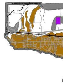
87
88
89
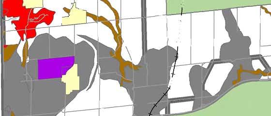
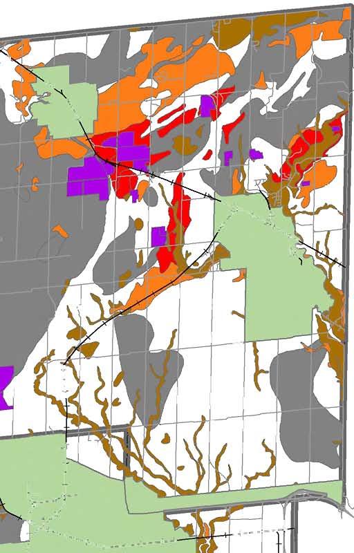
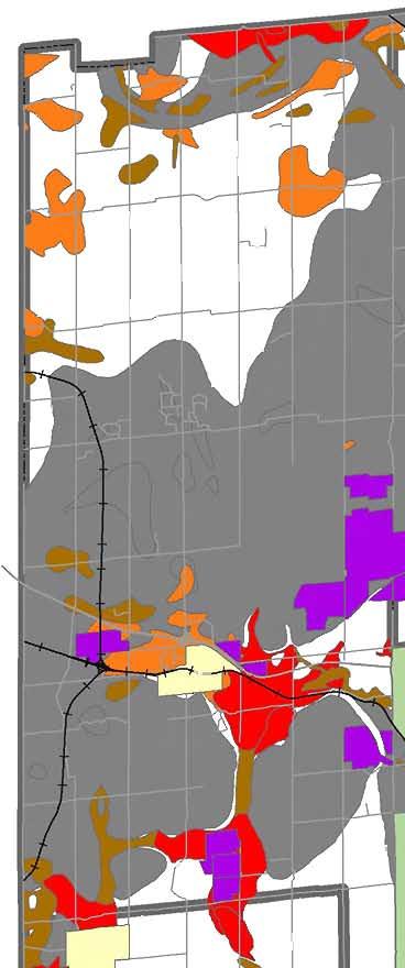
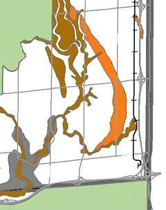
90
91
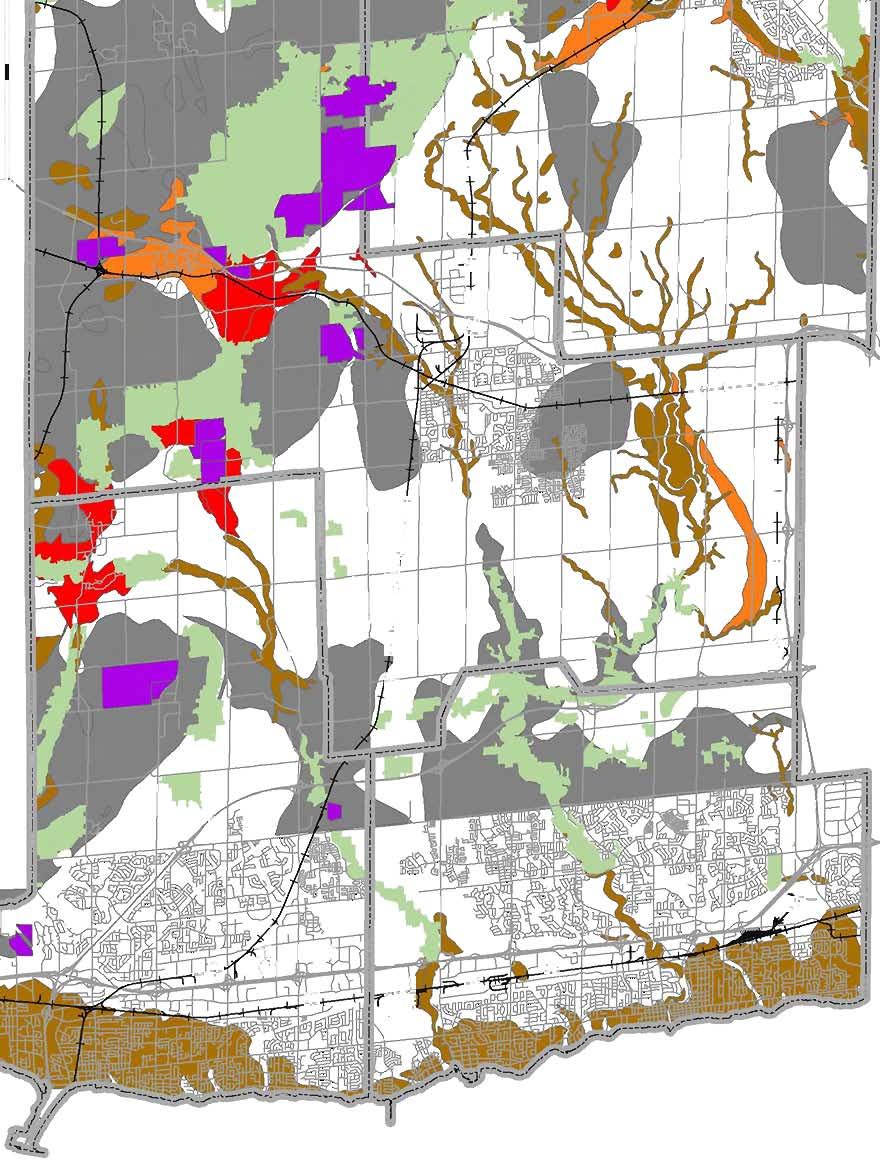
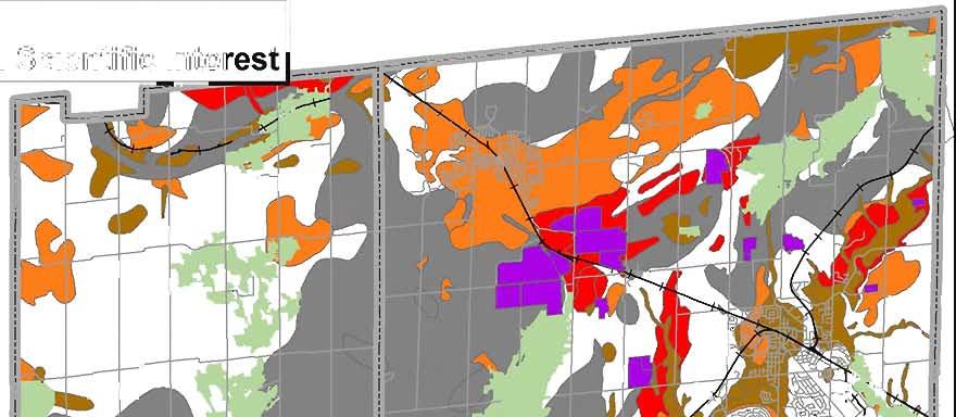
92
93
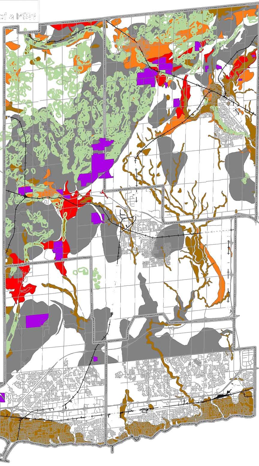
94
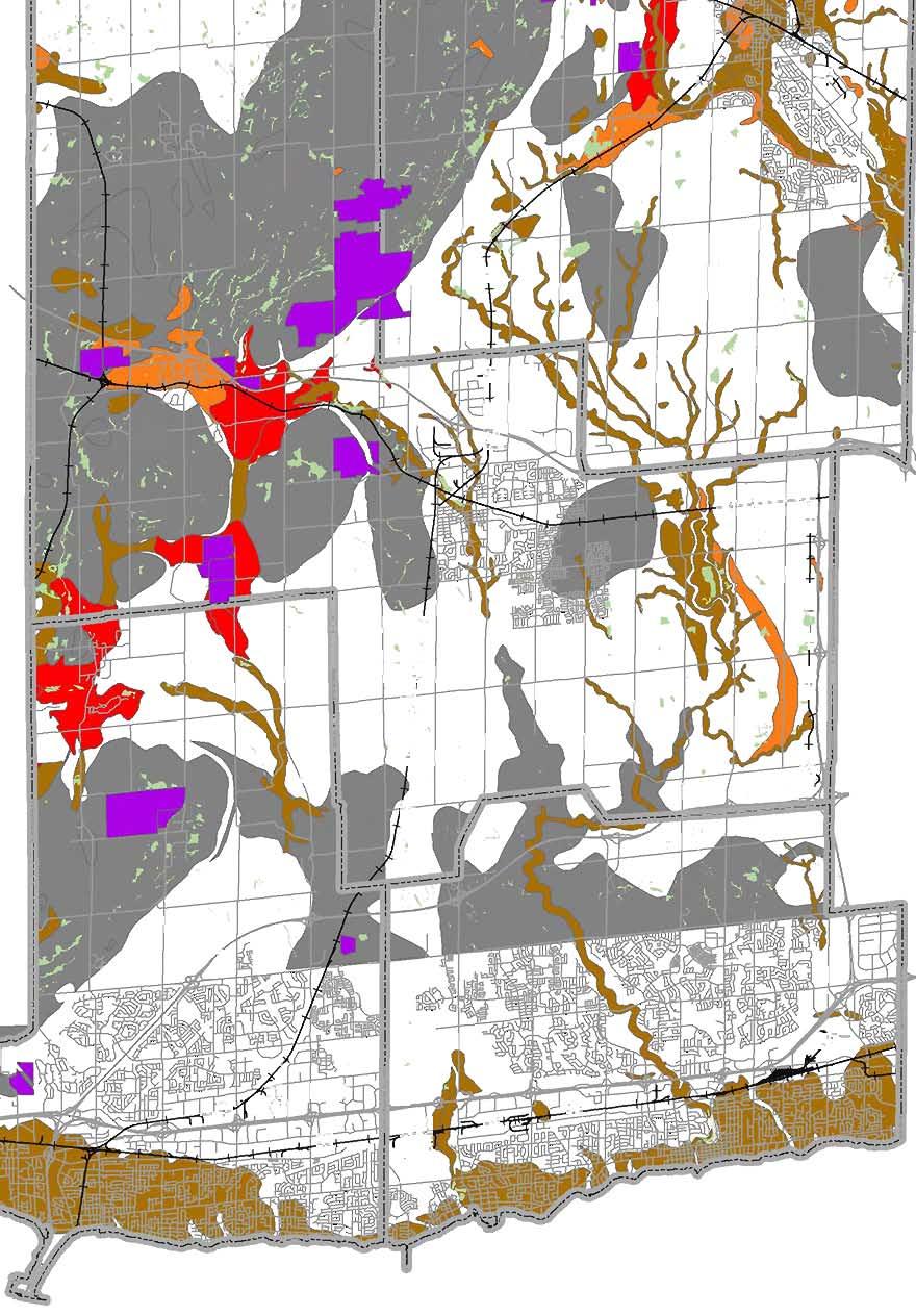
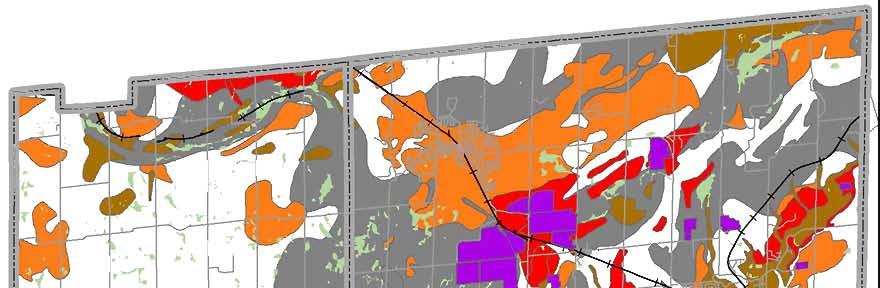
95
96
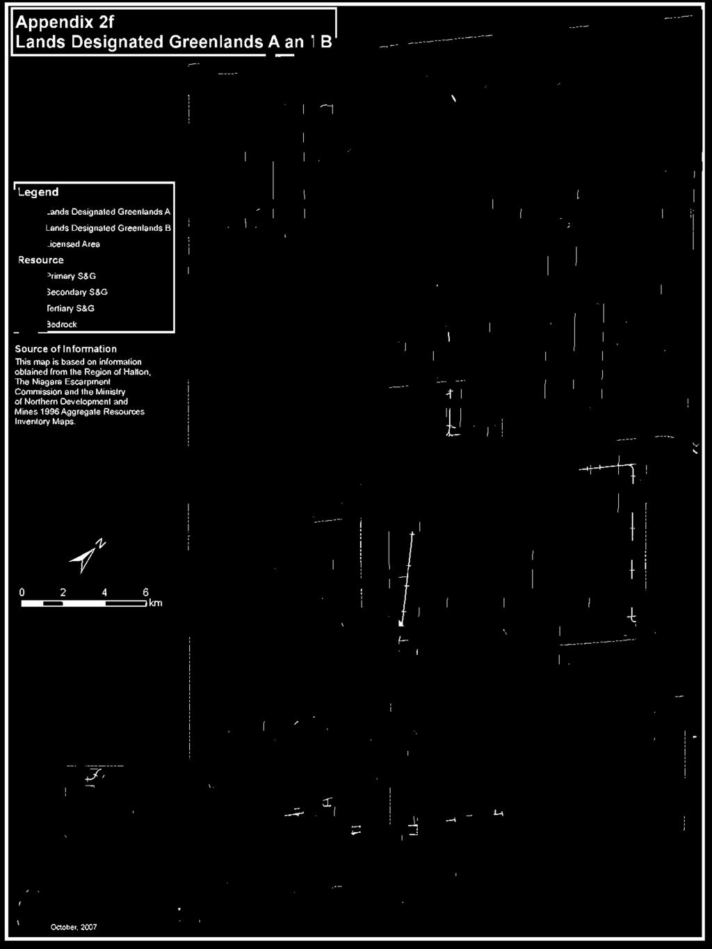
97
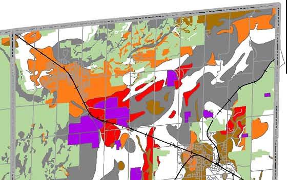
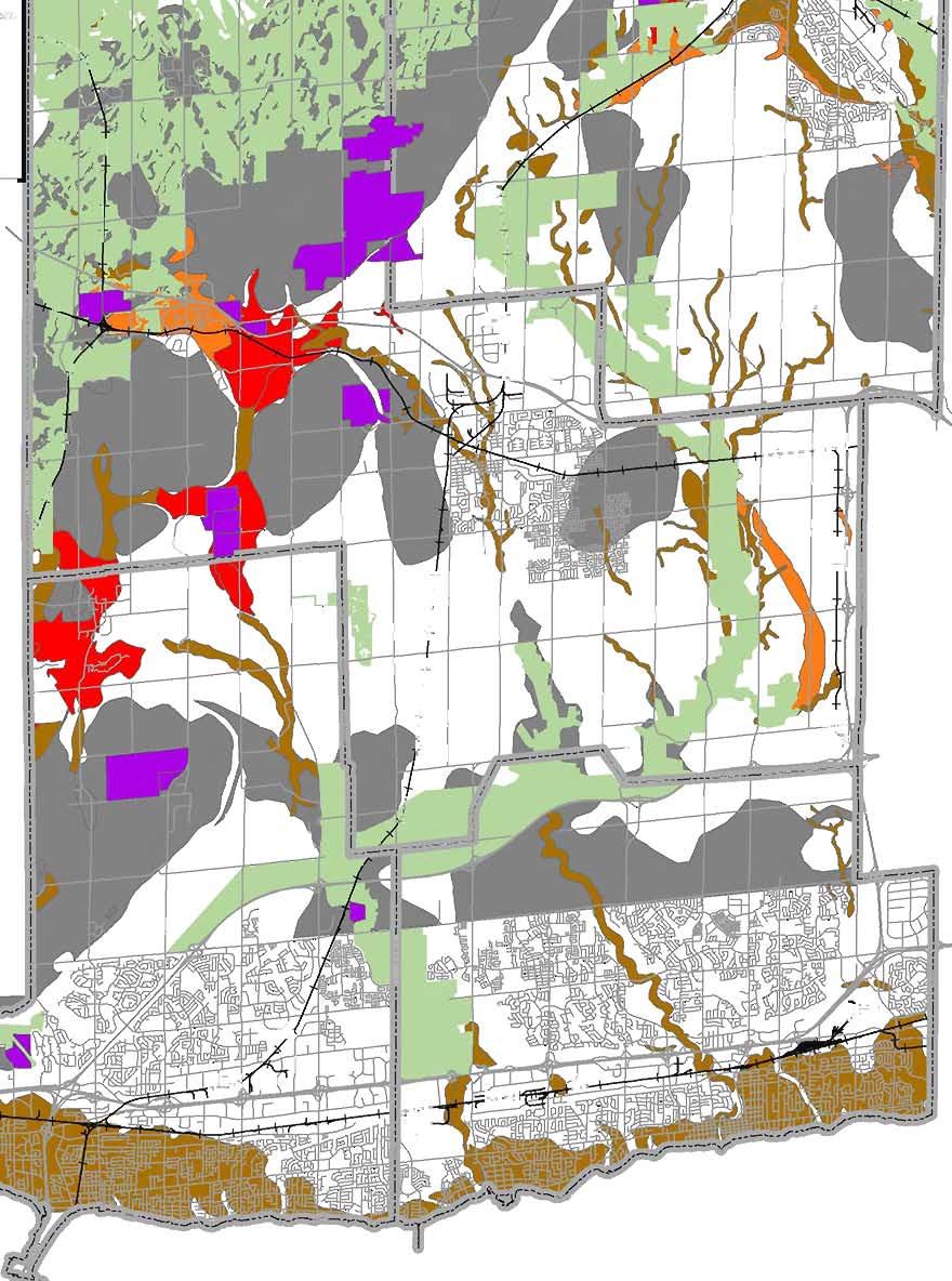
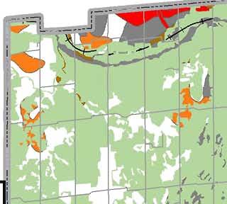
98
Aggregate Resources Reference Manual. Regional Official Plan Guidelines
 Aggregate Resources Reference Manual Regional Official Plan Guidelines Halton Region Official Plan Guidelines The Regional Official Plan (ROP) is Halton s guiding document for land use planning. It contains
Flamborough Quarry Haul Route Draft Transportation Report. Exhibit 3-9: Existing Transit Routes. October itrans Project # 4313
 Exhibit 3-9: Existing Transit Routes October 2008 36 Table 3-1: Transit Route Schedule Transit System Route Number and Name Frequency During Peak Periods Hamilton Street Railway GO Transit GO Transit GO
Aggregate Industry Discussion Paper
 : The Aggregate Industry Discussion Paper April 30, 2015 Overview Recommendations 1. The public and provincial interest in close to market aggregate supply can only be achieved if Provincial Plans contain
Aggregate Extraction in Ontario: A Strategy for the Future. Executive Summary
 Aggregate Extraction in Ontario: A Strategy for the Future Executive Summary March 2011 Aggregate Extraction in Ontario: A Strategy for the Future Executive Summary by Matt Binstock and Maureen Carter-Whitney
Aggregate Extraction, Rehabilitation & Current Research in Ontario. Muskoka Watershed Council - March 20, 2015
 Aggregate Extraction, Rehabilitation & Current Research in Ontario Aggregates 101 Production Statistics Legislation Rehabilitation Current Research What the future holds Questions Geology of Aggregates
TOWN OF HALTON HILLS TRUCKING STRATEGY STUDY. Council Workshop
 TOWN OF HALTON HILLS TRUCKING STRATEGY STUDY Council Workshop May 9, 2017 TOWN OF HALTON HILLS ONTARIO CANADA TRUCKING STRATEGY STUDY Presentation Overview 3 Purpose of Today s Meeting Part 1: About the
Preliminary Draft Haul Route Evaluation Report. Exhibit 3-3: Existing Road and Rail Network. itrans Project # May
 Exhibit 3-3: Existing Road and Rail Network May 2009 39 Exhibit 3-4: Road Jurisdictions May 2009 40 Exhibit 3-5: Road Classifications May 2009 41 3.11.2 Designated Truck Routes and Restrictions The designated
Town of Caledon Official Plan Chapter 5 Town Structure & Land Use Policies
 5.11 MINERAL RESOURCES The role of the Town of Caledon in the hierarchy of Provincial, Regional, and local aggregate resource planning, is to establish comprehensive mineral aggregate resource policies
Background and Policy Options Paper. Stand-Alone Aggregate Related Uses and Aggregate Transfer Stations OPEN HOUSE PRESENTATION OCTOBER 30, 2012
 Background and Policy Options Paper Stand-Alone Aggregate Related Uses and Aggregate Transfer Stations OPEN HOUSE PRESENTATION OCTOBER 30, 2012 BACKGROUND There is a need to study the land use planning
3.0 Natural Resource Management Policies. 3.4 Resource Extraction Policies
 3.0 Natural Resource Management Policies 3.4.1 Mineral Aggregates INTRODUCTION Oxford County is characterized by significant reserves of mineral aggregates, including bedrock-derived crushed stone and
Huron County Aggregate Resource Strategy
 A Report from the Technical Committee to the Steering Committee Report Authored by: Claire Dodds, Brian Treble and Andrea Vanderloo Huron County Planning Department on behalf of the Aggregate Strategy
JUNE 2010 TERMS OF REFERENCE: PEER REVIEW ASSIGNMENT FOR HYDROLOGICAL, HYDROGEOLOGICAL AND QUARRY DESIGN OPERATIONS ZONING APPLICATION REVIEW
 JUNE 2010 TERMS OF REFERENCE: PEER REVIEW ASSIGNMENT FOR HYDROLOGICAL, HYDROGEOLOGICAL AND QUARRY DESIGN OPERATIONS ZONING APPLICATION REVIEW The City of Brampton is seeks to retain the services of a consultant
Summary Assessment of Provincial Legislative Framework ONTARIO 1
 Summary Assessment of Provincial Legislative Framework ONTARIO 1 The strength of Ontario s legislative framework for protecting farmland is very strong. Most notably, as shown in Table 11, the framework
ST. MARYS FLAMBOROUGH QUARRY ST. MARYS CEMENT (CANADA) INC. ARA Summary Statement
 INC. ARA Summary Statement") ST. MARYS FLAMBOROUGH QUARRY ST. MARYS CEMENT (CANADA) INC. ARA Summary Statement TABLE OF CONTENTS PAGE 1.0 Introduction 1 1.1 Approval Process 2 1.2 St. Marys Cement (Canada) Inc. 3 1.3 Description of
ST. MARYS FLAMBOROUGH QUARRY ST. MARYS CEMENT (CANADA) INC. ARA Summary Statement TABLE OF CONTENTS PAGE 1.0 Introduction 1 1.1 Approval Process 2 1.2 St. Marys Cement (Canada) Inc. 3 1.3 Description of
PLANNING REPORT: Prepared for: Prepared by: PART LOT 27, CONCESSION 7 GEOGRAPHIC TOWNSHIP OF HOLLAND TOWNSHIP OF CHATSWORTH COUNTY OF GREY
 PLANNING REPORT: BUMSTEAD PIT Applications to Amend the County of Grey Official Plan and Chatsworth Zoning By-law to facilitate an Application for a Class A, Category 1 License for Mineral Resource Extraction
ADMINISTRATION OF AGGREGATE SOURCES INCLUDING EARTH AND ROCK BORROW SOURCES. Special Provision No. 199S38 March 2003
 ADMINISTRATION OF AGGREGATE SOURCES INCLUDING EARTH AND ROCK BORROW SOURCES Special Provision No. 199S38 March 2003 The following MTO specification is not based on or referenced to an OPS Specification.
REPORT. Chair and Members of Planning, Public Works & Transportation Committee
 REPORT REPORT TO: REPORT FROM: Chair and Members of Planning, Public Works & Transportation Committee Melissa Ricci, Planner Policy DATE: June 8, 2018 REPORT NO.: RE: PLS-2018-0054 Rural Policy and Zoning
Farmland Loss Trends, Predictions and Potential Action
 Farmland Loss Trends, Predictions and Potential Action By: Wayne Caldwell and Sara Epp Golden Horseshoe Food and Farming Alliance September 26, 2017 Presentation Outline Farmland in Ontario Why protect
5720 Timberlea Blvd., Ste. 103, Mississauga, ON L4W 4W
 February 8, 2016 Ms. Lisa Grbinicek Acting Manager Niagara Escarpment Commission 232 Guelph Street, Georgetown, ON L7G 4B1 Dear Ms. Grbinicek: RE: Provincial Plan Review - NEP Mapping OSSGA is a not-for
Executive Summary Planning for Health, Prosperity and Growth in the Greater Golden Horseshoe:
 Executive Summary Planning for Health, Prosperity and Growth in the Greater Golden Horseshoe: 2015-2041 Recommendations of the Advisory Panel on the Coordinated Review of the Growth Plan for the Greater
Strength. Performance. Passion. Paris Pit CAP. March 18, Holcim (Canada) Inc.
 Inc.") Strength. Performance. Passion. Paris Pit CAP March 18, 2014 2012 Holcim (Canada) Inc. Agenda Welcome Minutes from Last Meeting Dufferin Paris Pit - General Update Site Timeline Health & Safety - Silica
Strength. Performance. Passion. Paris Pit CAP March 18, 2014 2012 Holcim (Canada) Inc. Agenda Welcome Minutes from Last Meeting Dufferin Paris Pit - General Update Site Timeline Health & Safety - Silica
Lands & Waters Aggregate & Petroleum Resources March 15, 2006
 Subject: Policy No.: New: Ministry of Natural Resources Ministère des Richesses naturelles Licence / Site Plan Notes A.R. 2.00.03 Yes Compiled by Branch: Section: Date Issued: Lands & Waters Aggregate
PLANNING RATIONALE. R.W. Tomlinson Limited Brickyards 3150 & 3200 Rideau Road Part of Lots 26 & 27, Concession 5 (Gloucester) City of Ottawa
 City of Ottawa") PLANNING RATIONALE Brickyards 3150 & 3200 Rideau Road Part of Lots 26 & 27, Concession 5 (Gloucester) City of Ottawa Date: April 2016 REVISED June 2016 Prepared for: Prepared by: MacNaughton Hermsen Britton
PLANNING RATIONALE Brickyards 3150 & 3200 Rideau Road Part of Lots 26 & 27, Concession 5 (Gloucester) City of Ottawa Date: April 2016 REVISED June 2016 Prepared for: Prepared by: MacNaughton Hermsen Britton
Norma Trim, Chief Financial Officer and Commissioner of Corporate Services
 P Raion d Peel REPORT General Committee DATE: REPORT TITLE: PEEL REGION OFFICIAL PLAN REVIEW (PROPR) -ADOPTION OF REGIONAL OFFICIAL PLAN AMENDMENT NO. 218 - NATURAL HERITAGE AND AGRICULTURE POLICIES FROM:
REPORT Meeting Date: Regional Council
 8.2-1 REPORT Meeting Date: 2018-04-12 Regional Council DATE: April 10, 2018 REPORT TITLE: FROM: Janette Smith, Commissioner of Public Works RECOMMENDATION That Regional Council recommend to the Provincial
The Future Of Ontario s Close To Market Supply Of Aggregate g Provincial Plan Update
 Brian Zeman The Future Of Ontario s Close To Market Supply Of Aggregate g Provincial Plan Update 2 2015 Province Commenced An Update To 4 Provincial Plans 3 These Planning Policies Will Affect Aggregate
3. Problem and Opportunity Statement
 3. Problem and Opportunity Statement 3.1 Study Area Halton Region is situated in the west-central portion of the Greater Golden Horseshoe (please refer to Figure 2) and covers 959 square kilometres (370
SCHEDULE A REGION OF PEEL
 SCHEDULE A REGION OF PEEL REGION OF PEEL OFFICIAL PLAN AMENDMENT NUMBER - AMENDMENT TO ESTABLISH THE SOUTH ALBION-BOLTON EMPLOYMENT LANDS AND NORTH HILL SUPERMARKET SETTLEMENT SITE BOUNDARY EXPANSION -1-
TABLE OF CONTENTS. Figure 5: Modelled Concentrations of Suspended Particulate Worst-Case 24-Hour Average
 TABLE OF CONTENTS Page No. 1. INTRODUCTION... 1 1.1 Acton Quarry Extension... 1 1.1.1 Aggregate Resources Act... 1 1.1.2 Niagara Escarpment Planning & Development Act... 1 1.1.3 Planning Act... 1 1.2 Overview
OAK RIDGES MORAINE Groundwater Program
 celebrating 10 ten years OAK RIDGES MORAINE Groundwater Program SINCE 2001 Understanding and collecting the wealth of hydrogeological information generated over the last few decades will allow us to move
Chapter MINERAL EXTRACTION AND MINING OPERATIONS
 Chapter 17.31 MINERAL EXTRACTION AND MINING OPERATIONS Sections: 17.31.010 Purpose 17.31.020 Procedure for Extraction and Rehabilitation Requests 17.31.030 Operation and Rehabilitation Standards for all
PLANNING REPORT FLANAGAN PIT EXPANSION PART LOTS 1, CONCESSION 16 GEOGRAPHIC TOWNSHIP OF EGREMONT TOWNSHIP OF SOUTHGATE COUNTY OF GREY
 PLANNING REPORT FLANAGAN PIT EXPANSION Applications to Amend the County and Local Official Plans and Zoning By-law to facilitate and Application for a Class A, Category 3 License for Mineral Resource Extraction
A short History of the Rockfort Quarry Proposal
 Rockfort Quarry Information Evening November 19, 2008 A short History of the Rockfort Quarry Proposal Lorraine Symmes 1 Good evening everyone. My name is Lorraine Symmes and I m going to take you through
WHY ARE WE HERE? There are three applications for amendment to Adjala/Tosorontio from the Nelson Aggregate Company (LaFarge):
:") WHY ARE WE HERE? There are three applications for amendment to Adjala/Tosorontio from the Nelson Aggregate Company (LaFarge): 1. Pit to allow extraction of sand and gravel from below the established water
WHY ARE WE HERE? There are three applications for amendment to Adjala/Tosorontio from the Nelson Aggregate Company (LaFarge): 1. Pit to allow extraction of sand and gravel from below the established water
Amendment No. 38. An Amendment to Incorporate the Results of Sustainable Halton, Official Plan Review Directions and Other Matters
 Amendment No. 38 to THE REGIONAL PLAN (2006) Official Plan for the Halton Planning Area Regional Municipality of Halton An Amendment to Incorporate the Results of Sustainable Halton, Official Plan Review
Niagara Region Transportation Master Plan Niagara-Hamilton Trade Corridor Technical Paper
 Niagara-Hamilton Trade Corridor Technical Paper 1. Purpose In the report to Council on the Regional Council Strategic Priorities Implementation Plan, pursuing Provincial commitment for the Niagara to Greater
TOWN OF CALEDON PRIORITIES
 TOWN OF CALEDON PRIORITIES CONTEXT The Town of Caledon is Home to 71,600 people as of July, 2017 1 Growing at a rate of about 2.36% per year Land area spans 688.15 km 2 Home to 2,917 businesses 96% of
Protecting nature by working to protect the diversity and health of Canada's marine, freshwater, and terrestrial creatures and ecosystems;
 Tamara Pomanski Clerk pro tem./ Greffière par intérim Room 1405, Whitney Block/Bureau 1405, édifice Whitney Queen's Park, Toronto, ON M7A 1A2 July 16, 2012 Dear Ms. Pomanski Please accept this document
REPORT. Mayor Bonnette and Members of Council. Matthew T. Roj, Traffic Coordinator. Truck Strategy Update
 REPORT REPORT TO: REPORT FROM: Mayor Bonnette and Members of Council Matthew T. Roj, Traffic Coordinator DATE: April 16, 2014 REPORT NO.: RE: INF-2014-0015 Truck Strategy Update RECOMMENDATION: THAT Report
The Regional Municipality of Halton. Chair and Members of the Planning and Public Works Committee
 The Regional Municipality of Halton Report To: From: Chair and Members of the Planning and Public Works Committee Mark G. Meneray, Commissioner, Legislative & Planning Services and Corporate Counsel Date:
Land Evaluation & Area Review (LEAR) Study and Minimum Distance Separation (MDS) Review
 Study and Minimum Distance Separation (MDS) Review") These displays were presented at the Public Information Open House for the Land Evaluation & Area Review (LEAR) Study and Minimum Distance Separation (MDS) Review April 3, 2014 7pm-9pm Brampton Fairgrounds,
These displays were presented at the Public Information Open House for the Land Evaluation & Area Review (LEAR) Study and Minimum Distance Separation (MDS) Review April 3, 2014 7pm-9pm Brampton Fairgrounds,
Southwestern Landfill Environmental Assessment
 CLC Consultation Booklet Landfill Footprint & Design Alternatives Southwestern Landfill Environmental Assessment This booklet has information about different options for landfill footprint and landfill
Surplus Farm Dwelling Severances. Planning & Public Works Committee June 7, 2017
 Surplus Farm Dwelling Severances Planning & Public Works Committee June 7, 2017 1 Regional Official Plan Objectives 99(4) To protect farms from incompatible activities and land uses which would limit agricultural
Public Information Centre #1. March 2010
 Public Information Centre #1 March 2010 Purpose of Public Information Centre Halton Region is initiating a Transportation Master Plan (2031) The Road to Change The Plan will develop a sustainable, integrated
A Review and Evaluation of the Effectiveness of the Niagara Escarpment Plan Regarding Proposals to Expand Urban Areas and Minor Urban Centres
 A Review and Evaluation of the Effectiveness of the Niagara Escarpment Plan Regarding Proposals to Expand Urban Areas and Minor Urban Centres January 2004 Prepared by: Alan Ernest, M.A. 381 Carlisle Road
DRAFT Agricultural Impact Assessment (AIA) Guidelines
 Guidelines") DRAFT Agricultural Impact Assessment (AIA) Guidelines November 7, 2011 Legislative & Planning Services Sustainable Communities. Economic Opportunities. Transparent Government. Prepared with the assistance
DRAFT Agricultural Impact Assessment (AIA) Guidelines November 7, 2011 Legislative & Planning Services Sustainable Communities. Economic Opportunities. Transparent Government. Prepared with the assistance
Introduction Category 15
 Introduction Category 15 These Standards 1 have been developed to support the Aggregate Resources Act as amended by Bill 52, the Aggregate and Petroleum Resources Statute Law Amendment Act, 1996. There
Spencer Pit. Summary Report. Tri City Lands Ltd. Part Lots 14, 15 and 16, Township of Guelph/ Eramosa County of Wellington.
 Summary Report Tri City Lands Ltd. Spencer Pit Part Lots 14, 15 and 16, and Lots 17 and 18, Concession B Township of Guelph/ Eramosa County of Wellington April 2014 6882 14 th Avenue, Markham, ON L6B 1A8
This policy discussion paper has been prepared for the Town of Whitby by Meridian Planning Consultants with the assistance of GLPi.
 table of contents 1.0 INTRODUCTION... 2 2.0 LOCATION OF AGRICULTURAL AREA IN WHITBY... 3 3.0 THE STATE OF AGRICULTURE IN WHITBY... 5 4.0 PROVINCIAL POLICY AND AGRICULTURE... 9 4.1 Provincial Policy Statement...
4.10 MINERAL RESOURCES
 4.10 MINERAL RESOURCES SCOPE AND METHODOLOGY This section examines the City s predominant mineral resource, aggregate, and the current mining operations in place to extract aggregate. Reclamation and reuse
Development Approval & Planning Policy Department. Subject: Bolton Residential Expansion Study: Selection of Expansion Area
 DP-2013-091 To: From: Mayor and Members of Council Development Approval & Planning Policy Department Meeting: 2013-07-09 Subject: Bolton Residential Expansion Study: Selection of Expansion Area RECOMMENDATIONS
Ontario s Sand and Gravel Extraction Policy: Overdue for Review
 The ECO also urges MOE to develop a comprehensive plan to update the requirements/ standards applied to aging, active landfill sites, both large and small, approved prior to August of 1998. This could
Provincial Policy Statement 2014
 Natural Heritage Provincial Policy Statement 2014 NATURAL HERITAGE Nature is bountiful. It is also fragile and finite. Provincial Natural Heritage 0 Interest: Ontario s natural heritage resources are valuable
AMENDMENT NO. 30 TO THE OFFICIAL PLAN CORPORATION OF THE UNITED COUNTIES OF PRESCOTT AND RUSSELL
 DRAFT 1 AMENDMENT NO. 30 TO THE OFFICIAL PLAN CORPORATION OF THE UNITED COUNTIES OF PRESCOTT AND RUSSELL Prepared by: Planning and Forestry Department United Counties of Prescott and Russell 59 Court Street
EXECUTIVE SUMMARY 1. OVERVIEW OF TRANSPORTATION PROBLEMS AND OPPORTUNITIES
 EXECUTIVE SUMMARY 1. OVERVIEW OF TRANSPORTATION PROBLEMS AND OPPORTUNITIES The GTA West Corridor has been identified in the Growth Plan for the Greater Golden Horseshoe as a future transportation corridor,
Corporate Report. CD.21.PEE (Region of Peel) DATE: September 25, Chair and Members of Planning and Development Committee October 2, 2006 TO:
 DATE: September 25, Chair and Members of Planning and Development Committee October 2, 2006 TO:") Corporate Report Clerk s Files Originator s Files CD.21.PEE (Region of Peel) DATE: September 25, 2006 TO: FROM: SUBJECT: Chair and Members of Planning and Development Committee October 2, 2006 Edward R.
Corporate Report Clerk s Files Originator s Files CD.21.PEE (Region of Peel) DATE: September 25, 2006 TO: FROM: SUBJECT: Chair and Members of Planning and Development Committee October 2, 2006 Edward R.
TRANSPORTATION DEMAND FORECASTING INFORMATION SESSION
 GTA WEST CORRIDOR PLANNING AND EA STUDY-STAGE STAGE 1 TRANSPORTATION DEMAND FORECASTING INFORMATION SESSION JUNE 2008 Topics for this Session 1. The Challenge of Growth 2. Overview of GTAW Study 3. The
Section 6 Table of Contents. List of Tables. List of Figures
 Section 6 Table of Contents 6. The Study Area... 6-3 6.1 Study Area Environment... 6-3 6.1.1 Natural Environment... 6-3 6.1.2 Socio-Economic... 6-4 6.1.3 First Nations Communities... 6-4 6.1.4 Economic
Provincial. Statement
 Provincial Statement This publication was produced by the Ministry of Municipal Affairs and Housing. For more copies of this document, in either English or French, please contact: Publications Ontario
Pits & Quarries in Ontario. Module 3 Aggregate Extraction & Source Water Protection
 Pits & Quarries in Ontario Module 3 Aggregate Extraction & Source Water Protection Key Messages 1. Aggregate producers are primarily water handlers, not consumers 2. Site rehabilitation creates water assets
March 7, Background
 March 7, 2018 Protecting Water Ministry of Municipal Affairs and Housing Local Government and Planning Policy Division Provincial Planning Policy Branch 777 Bay Street, Floor 13 Toronto, ON M5G 2E5 RE:
1 AMENDMENT NO. 637 TO THE VAUGHAN OFFICIAL PLAN (VAUGHAN 400 NORTH EMPLOYMENT AREA SECONDARY PLAN) ONTARIO MUNICIPAL BOARD HEARING SETTLEMENT
 ONTARIO MUNICIPAL BOARD HEARING SETTLEMENT") Report No. 7 of the Planning and Economic Development Committee Regional Council Meeting of September 22, 2011 1 AMENDMENT NO. 637 TO THE VAUGHAN OFFICIAL PLAN (VAUGHAN 400 NORTH EMPLOYMENT AREA SECONDARY
Report No. 7 of the Planning and Economic Development Committee Regional Council Meeting of September 22, 2011 1 AMENDMENT NO. 637 TO THE VAUGHAN OFFICIAL PLAN (VAUGHAN 400 NORTH EMPLOYMENT AREA SECONDARY
Sustainable Halton Overview of ROPA 38
 Sustainable Halton Overview of ROPA 38 Public Open House October, 2009 What is ROPA 38 about? Fulfilling the provincial requirements under the Growth Plan, the Greenbelt Plan, the Provincial Policy Statement
Protecting and Maintaining Canada s Agricultural Land for Food Production
 Protecting and Maintaining Canada s Agricultural Land for Food Production Presentation to 3 rd Annual Food Summit Conference Board of Canada March 2014 The Lay of the Land Presentation A look at Canada
noise impact study project number: 03117
 noise impact study project number: 3117 THE POTENTIAL IMPACT OF NOISE FROM AGGREGATE EXTRACTION & PROCESSING AT THE PROPOSED MCCORMICK PIT Part of Lot 12, Concession 2 EHS Township of Caledon, Region of
THE REGIONAL MUNICIPALITY OF PEEL GROWTH MANAGEMENT COMMITTEE
 THE REGIONAL MUNICIPALITY OF PEEL GROWTH MANAGEMENT COMMITTEE AGENDA GMC - 3/2016 DATE: Thursday, June 16, 2016 TIME: LOCATION: 9:00 AM 10:30 AM Regional Council Chamber, 5th Floor Regional Administrative
Imperial s Sarnia Products Pipeline
 Imperial s Sarnia Products Pipeline Waterdown to Finch Project Community Information Session Imperial s Waterdown to Finch Project Important infrastructure to the Greater Toronto and Hamilton Area (GTHA).
Introduction Category 1
 Introduction Category 1 These Standards 1 have been developed to support the Aggregate Resources Act as amended by Bill 52, the Aggregate and Petroleum Resources Statute Law Amendment Act, 1996. There
BUMSTEAD PIT. Part Lot 27, Concession 7 Geographic Township of Holland Township of Chatsworth County of Grey
 BUMSTEAD PIT Applications to Amend the County of Grey Official Plan and Township of Chatsworth Zoning By-law to facilitate an Application for a Class A, Category 1 License for Mineral Resource Extraction
Wetland Rehabilitation. Surrendered Aggregate Sites in Ontario s Provincial Plan Areas August 15, 2017
 Wetland Rehabilitation Surrendered Aggregate Sites in Ontario s Provincial Plan Areas August 15, 2017 Executive Summary The preservation and restoration of aquatic habitat and wetland ecosystems across
The Regional Municipality of York. Review of Regional Council Governance
 The Regional Municipality of York Committee of the Whole October 13, 016 Report of the Regional Chair Review of Regional Council Governance 1. Recommendations It is recommended that Council receive this
Duntroon License Expansion Agricultural Impact Assessment
 Duntroon License Expansion Agricultural Impact Assessment September 2005 File No. 162602732 Prepared by: Stantec Consulting Ltd. 361 Southgate Drive Guelph, ON N1G 3M5 Prepared for: Georgian Aggregates
REPORT. Mayor R. Bonnette and Members of Council. John Linhardt, Manager of Planning Policy PDS
 REPORT REPORT TO: REPORT FROM: Mayor R. Bonnette and Members of Council John Linhardt, Manager of Planning Policy DATE: November 8, 2010 REPORT NO.: RE: PDS-2010-0096 Regional Official Plan Amendment No.
PROVINCIAL POLICY STATEMENT COMPARISON
 PROVINCIAL POLICY STATEMENT 2005-2014 COMPARISON TRACKED CHANGES VERSION This document compares Provincial Policy Statement, 2005 and Provincial Policy Statement, 2014. Additions are shown in grey highlighting
Introduction- Category 9
 Introduction- Category 9 These Standards 1 have been developed to support the Aggregate Resources Act as amended by Bill 52, the Aggregate and Petroleum Resources Statute Law Amendment Act, 1996. There
Wetland Rehabilitation. Surrendered Aggregate Sites in Ontario s Provincial Plan Areas
 Wetland Rehabilitation Surrendered Aggregate Sites in Ontario s Provincial Plan Areas Executive Summary The preservation and restoration of aquatic habitat and wetland ecosystems across Southern Ontario
Approved Health and Social Services Committee No October 18, 2005 Adopted Regional Council No October 26, 2005
 Approved Health and Social Services Committee No. 12 05 October 18, 2005 Adopted Regional Council No. 12 05 October 26, 2005 THE REGIONAL MUNICIPALITY OF HALTON Report To: From: Chairman and Members of
GENERAL SPECIFICATION FOR THE MANAGEMENT OF EXCESS MATERIALS
 ONTARIO PROVINCIAL STANDARD SPECIFICATION METRIC OPSS 180 NOVEMBER 2011 GENERAL SPECIFICATION FOR THE MANAGEMENT OF EXCESS MATERIALS TABLE OF CONTENTS 180.01 SCOPE 180.02 REFERENCES 180.03 DEFINITIONS
Towards Performance. Preliminary Indicators for Discussion
 Towards Performance Indicators FOR THE Growth Plan for the Greater Golden Horseshoe, 2006 Preliminary Indicators for Discussion Overview Greater Golden Horseshoe How are we doing? This document introduces
Town of Huntsville Official Plan Section 9 Rural Area Page 104
 Section 9 Rural Area Page 104 9 RURAL AREA 9.1 Definition and Function Location Rural Settlements 9.1.1 The Rural Area includes those lands located outside any other land use designation identified in
Commission de I'escarpernent du Niagara.
 Niagara Escarpment Commission Commission de I'escarpernent du Niagara 232 Guelph St. 232, rue Guelph Georgetown, ON L7G 4B1 Georgetown ON L7G 4B1 Tel: 905-877-5191 No de tel. 905-877-5191 Fax: 905-873-7452
GRADING PERMIT CITY OF RAPID CITY 300 SIXITH STREET RAPID CITY, SD ID NO: (605) PIN NO:
 PIN NO:") PERMIT NUMBER: GRADING PERMIT CITY OF RAPID CITY 300 SIXITH STREET RAPID CITY, SD 57701 ID NO: (605) 394-4157 PIN NO: APPLICATION DATE: DATE ISSUED: PROPERTY INFORMATION CONTRACTOR INFORMATION LOT ADDRESS
PERMIT NUMBER: GRADING PERMIT CITY OF RAPID CITY 300 SIXITH STREET RAPID CITY, SD 57701 ID NO: (605) 394-4157 PIN NO: APPLICATION DATE: DATE ISSUED: PROPERTY INFORMATION CONTRACTOR INFORMATION LOT ADDRESS
Debrob Investments Limited FUNCTIONAL SERVICING REPORT DRAFT PLAN OF SUBDIVISION, CITYVIEW DRIVE CITY OF GUELPH
 JULY 2013 DOCUMENT CONTROL Client: Project Name: Report Title: IBI Reference: 25528 Cityview Drive Version: JULY 2013 Digital Master: Originator: Reviewer: Authorization: [File Location] Scott MacDonald,
INDEX FOR SPECIFICATIONS FOR AGGREGATE FOR BITUMINOUS PAVEMENT SCOPE... 2
 February 2017 No. 920(I) INDEX FOR SPECIFICATIONS FOR AGGREGATE FOR BITUMINOUS PAVEMENT 920. 1 SCOPE... 2 920. 3 MATERIALS 3.1 Source of Supply... 2 3.2 Aggregate Requirements... 2 3.3 Mix Design... 3
The Regional Municipality of Halton. Chair and Members of the Planning and Public Works Committee
 Approved - Planning and Public Works - Oct 21, 2009 Amended - Regional Council - Oct 28, 2009 The Regional Municipality of Halton Report To: From: Chair and Members of the Planning and Public Works Committee
ENVIRONMENT ACT TERMS OF REFERENCE NOVA SCOTIA DEPARTMENT OF TRANSPORTATION AND PUBLIC WORKS. Beaver Bank Bypass
 ENVIRONMENT ACT TERMS OF REFERENCE NOVA SCOTIA DEPARTMENT OF TRANSPORTATION AND PUBLIC WORKS Beaver Bank Bypass Highway 101 to the Beaver Bank Road Halifax County, NS NOVA SCOTIA DEPARTMENT OF THE ENVIRONMENT
Natural aggregates. Type 1
 Materials used to build a path base layer are generally well graded granular sub base materials which help to spread the weight and forces of different path users in to formation layer below. The base
TECHNICAL SUPPORT DOCUMENT # 1 COMPARATIVE EVALUATION OF ALTERNATIVE SITES APPENDIX TDS#1-G. Agriculture Component
 TECHNICAL SUPPORT DOCUMENT # 1 COMPARATIVE EVALUATION OF ALTERNATIVE SITES APPENDIX TDS#1-G Agriculture Component February 2013 February 2013 Agriculture Component Appendix TSD#1-G COMPARATIVE EVALUATION
5 SUTTON/JACKSON'S POINT SECONDARY PLAN
 Report No. 3 of the Planning and Economic Development Committee Regional Council Meeting of March 24, 2011 5 SUTTON/JACKSON'S POINT SECONDARY PLAN The Planning and Economic Development Committee recommends:
Draft Agricultural Impact Assessment (AIA) Guidance Document. March 2018
 Guidance Document. March 2018") Draft Agricultural Impact Assessment (AIA) Guidance Document March 2018 1.0 Overview... 3 1.1 The Importance of Agriculture in Ontario... 3 1.2 Purpose and Scope of this Guidance Document... 4 1.3 What
Draft Agricultural Impact Assessment (AIA) Guidance Document March 2018 1.0 Overview... 3 1.1 The Importance of Agriculture in Ontario... 3 1.2 Purpose and Scope of this Guidance Document... 4 1.3 What
RPP SEPTEMBER 27, 2017 SEPTEMBER
 APPENDIX VI MAYFIELD WEST PHASE 2 STAGE 2 PLANNING JUSTIFICATION REPORT Prepared by Nick McDonald, RPP SEPTEMBER 27, 2017 SEPTEMBER TABLE OF CONTENTS 1.0 OVERVIEW... 3 1.1 PURPOSE OF REPORT... 3 1.2 PLANNING
Report No. 6 of the Planning and Economic Development Committee Regional Council Meeting of June 23, 2005
 8 ASSIMILATIVE CAPACITY STUDY: LAKE SIMCOE AND NOTTAWASAGA RIVER WATERSHED (ACS) PHASE 1 OF THE INTERGOVERNMENTAL ACTION PLAN FOR SIMCOE, BARRIE AND ORILLIA (IGAP) The Planning and Economic Development
a) an attached accessory dwelling or a detached accessory dwelling in accordance with the provisions of the Accessory Dwelling General Provisions.
 an attached accessory dwelling or a detached accessory dwelling in accordance with the provisions of the Accessory Dwelling General Provisions.") SECTION 28 - EXTRACTIVE INDUSTRIAL (ME) ZONE 28.1 Within an Extractive Industrial (ME) Zone, no person shall use any land; erect, alter, enlarge, use or maintain any building or structure for any use other
SECTION 28 - EXTRACTIVE INDUSTRIAL (ME) ZONE 28.1 Within an Extractive Industrial (ME) Zone, no person shall use any land; erect, alter, enlarge, use or maintain any building or structure for any use other
Re: OSSGA comments on Agricultural Impact Assessment Guidance Document
 July 11, 2018 Michele Doncaster Policy Advisor Ministry of Agriculture, Food and Rural Affairs Policy Division Land Use Policy Unit 1 Stone Rd., Floor 3 Guelph, Ontario N1G 4Y2 (sent via email to michele.doncaster@ontario.ca)
January 16, Mr. David Trotman Mono Centre Road Mono, ON L9W 6S3
 Ministry of Municipal Affairs Ministry of Housing Ministère des Affaires municipales Ministère du Logement Municipal Services Office Bureau des services aux municipalités Western Ontario de l Ouest de
The Places to Grow Act, 2005 and Transition Regulation MINISTRY OF PUBLIC INFRASTRUCTURE RENEWAL 1
 The Places to Grow Act, 2005 and Transition Regulation MINISTRY OF PUBLIC INFRASTRUCTURE RENEWAL 1 Learning Objectives To understand the Places to Grow Act, 2005. To understand the structure and relationship
Town of Niagara-on-the-Lake Official Plan Review. Discussion Paper: Agricultural Background. Prepared for: The Town of Niagara-on-the-Lake
 Town of Niagara-on-the-Lake Official Plan Review Discussion Paper: Agricultural Background Prepared for: The Town of Niagara-on-the-Lake October 15, 2015 PLANSCAPE Inc. Building Community through Planning
Summary Statement PLANNING REPORT & AGGREGATE RESOURCES ACT. Part of Lot 3, Concessions 1 and 2, Township of Clearview, County of Simcoe OSTER PIT
 PLANNING REPORT & AGGREGATE RESOURCES ACT Summary Statement OSTER PIT Part of Lot 3, Concessions 1 and 2, Township of Clearview, County of Simcoe Date: October 2016 Prepared for: Lafarge Canada Inc. Prepared
APPENDIX A REVIEW OF NATURAL HERITAGE SYSTEM POLICIES AND MAPS
 APPENDIX A REVIEW OF NATURAL HERITAGE SYSTEM POLICIES AND MAPS MARCH 16, 2017 TABLE OF CONTENTS A1. NHS POLICY IN THE ROP... 3 A2. RNHS POLICY IN THE ROP... 3 A3. CONSTRAINTS TO DEVELOPMENT IN THE GREENBELT