Project Deliverable Concept of Operations and Area Architecture Report
|
|
|
- Sabrina Wilson
- 5 years ago
- Views:
Transcription

1 Pomona Valley ITS Project Project Deliverable Concept of Operations and Area Architecture Report Prepared by: November 14, Copyright 2002, Kimley-Horn and Associates, Inc.
2 TABLE OF CONTENTS Concept of Operations and Area Architecture Report PROJECT DESCRIPTION BACKGROUND PURPOSE OF REPORT DEFINITIONS METHODOLOGY REPORT ORGANIZATION CONCEPT OF OPERATIONS LEVEL 3 POMONA VALLEY SUBREGIONAL TRAFFIC MANAGEMENT CENTER (TMC) AND LA COUNTY TMC LOCAL CONTROL CENTER LOCAL MONITORING ONLY SITE EISTING SYSTEMS AND ARCHITECTURES LOS ANGELES AND VENTURA COUNTIES ITS STRATEGIC DEPLOYMENT PLAN (SDP) EISTING AND PLANNED POMONA VALLEY ATMS City of Pomona LA County Planned Advanced Traffic Management System (ATMS) INFORMATION ECHANGE NETWORK CALTRANS DISTRICT 7 ATMS POMONA VALLEY AREA ITS ARCHITECTURE LOGICAL ARCHITECTURE PHYSICAL ARCHITECTURE Transportation Layer Center Subsystems Roadside Subsystems Vehicle Subsystems Traveler Subsystems Communications Layer Market Packages Institutional Layer...22 LIST OF ACRONYMS...21 APPENDI USER SERVICES /14/02
3 LIST OF FIGURES FIGURE 4-1 POMONA VALLEY AREA LOGICAL ARCHITECTURE FIGURE 4-2 POMONA VALLEY AREA INTERCONNECT DIAGRAM FIGURE 4-3 PVITS CENTER-TO-CENTER COMMUNICATIONS FIGURE 4-4 LOCAL CTCS INTERCONNECT DETAIL LIST OF TABLES TABLE 3-2 LOS ANGELES/VENTURA SDP USER SERVICES...7 TABLE 3-4 CALTRANS DISTRICT 7 ATMS...9 TABLE 4-1 PVITS AREA ARCHITECTURE USER SERVICES /14/02
4 PROJECT DESCRIPTION The County of Los Angeles, in cooperation with the cities within the Pomona Valley, has determined that development of an Intelligent Transportation System (ITS) in the Pomona Valley would help to reduce congestion, enhance mobility, provide traveler information during non-recurring and event traffic congestion, and manage event traffic. The Pomona Valley Intelligent Transportation Systems (PVITS) project was conceived as a recommendation from the Pomona Valley ITS Feasibility Study completed by the LACMTA in The ultimate objectives of the Project are to: Improve mobility by optimizing traffic management on arterials and freeways; Enhance Route 60 capacity by better coordinating freeway traffic with parallel arterials; Improve agency efficiency by coordinating management of operations and maintenance efforts among and between agencies; and Increase agency staff productivity by providing low-maintenance, high-quality communications and computational tools to assist in daily management and coordination activities. Phase 1 of the PVITS project is the development of a conceptual design that defines solutions to enhance capacity, reduce congestion, and improve traveler information in the Pomona Valley. 1 11/14/02
5 1.0 BACKGROUND 1.1 Purpose of Report With the completion of Task 5, Requirements Analysis, of the PVITS project, the needs of the project stakeholders and requirements of the systems proposed for deployment have now been documented. Once requirements are completed, the next step of a typical ITS project is to develop an architecture and concept of operations. An architecture is a framework that describes how different systems, subsystems and ITS components interact and exchange information to achieve regional goals and objectives. An area architecture provides guidelines for interconnecting existing and future systems within the region. In doing so, the architecture framework provides the ability to accommodate technology changes, evolution, and growth of the system. Rather than installing technologies and implementing systems in a piecemeal fashion, it is important to have a framework in place in which the various systems will be designed and integrated to satisfy regional goals and objectives. By establishing this framework (the ITS architecture) for ITS deployment in the Pomona Valley, the project partners will be able to design and implement projects that meet both local needs and regional goals, and comply with Federal funding requirements. The architecture must also address consistency issues between the ITS deployments in the Pomona Valley and demonstrate compliance with national architecture standards. This will minimize the risks involved in deployment of the ITS technologies, and improve interjurisdictional and public-private communications. As a part of the architecture, flow diagrams to identify the position and importance of the ITS elements within the regional ITS deployment should also be identified. The requirements for linking to each of the existing systems within the study area will address the standards and protocols required by each jurisdiction. The project architecture provides the framework within which the traffic control equipment would operate, will serve as a framework for regional ITS project development and design. The purpose of the Pomona Valley area architecture is to ensure that ITS components and projects that are deployed are built in an integrated fashion; building on each other and capitalizing on the infrastructure and operational funding for the region. The proposed architecture lays the foundation for establishing communication links and seamless exchange of traffic and traveler information among different agencies and subsystems. The process of ensuring consistency with the architecture for other projects deployed in the Pomona Valley will ensure that an integrated system continues to be deployed into the future. Specifically, the ITS architecture: Identifies the different transportation management agencies in the Pomona Valley and describes how they will interact; Identifies telecommunications connections and transportation data flows required among participants; Supports the development of open systems (i.e., systems with interfaces that use standard or known ITS communication protocols); Incorporates existing and planned systems; Accommodates new technologies in the future; Provides a framework for multiple design choices; and 2 11/14/02
6 Provides a structure for future planning and growth. 1.2 Definitions The proposed Pomona Valley ITS Architecture was developed using the National ITS Architecture concepts and nomenclature. The following are terms used in the National Architecture and in this report to describe the data, processes, and infrastructure that form the existing and future elements of the Pomona Valley ITS architecture. The logical architecture defines what needs to be done functionally to support the selected user services. It does so through the use of processes, which perform ITS functions; terminators, which define the end points of the architecture, and connecting data flows that are needed to support those user services. Many different processes must work together and share information to provide a user service. User services describe what functions ITS will provide to users (travelers, traffic managers etc.) to contribute to meeting the users transportation needs. As such, the selection of the user services forms the basis for the logical architecture. The physical architecture provides a high-level definition of the major system components and interfaces. The physical architecture is based on market packages. Market Packages describe the physical components required to implement a particular user service. A market package may meet one or more user services. A market package can be further broken down into subsystems, terminators, and their connecting architecture flows, or data flows. The institutional layer of the physical architecture represents the institutional arrangements that exist or will be required in the Pomona Valley Forum that form the context in which the architecture elements will be deployed. This layer deals with policies, working arrangements, and the jurisdictional structure that support the technical layers of the system architecture. 1.3 Methodology The Pomona Valley ITS architecture development builds on the previously identified stakeholder objectives. User services that would have the potential of meeting those objectives were then selected from a predefined list in the National Architecture. This list of user services forms the basis of the logical architecture. The user services were mapped to market packages. The market packages were used to derive the physical architecture. 1.4 Report Organization The information in this report is presented in the following sections: Section 1 Background Section 2 Concept of Operations Section 3 Existing Systems and Architectures Section 4 Proposed Pomona Valley Architecture (logical and physical) 2.0 CONCEPT OF OPERATIONS The Concept of Operations for PVITS, describes in story terms: 3 11/14/02
7 how the different systems and subsystems will work together; how the agencies and operators will interact in daily operational situations; how traffic gets managed; and how traveler information gets to the public. The following sections describe typical daily operations for each system level as defined in other LA County projects in the subregion. For clarification purposes, these levels can be described as follows: Level 3 Pomona Valley Subregional Traffic Management Center (TMC) and LA County TMC Level 2 Local City Control Site (LCC) Level 1 Local Monitoring Only Site 2.1 Level 3 Pomona Valley Subregional Traffic Management Center (TMC) and LA County TMC The TMC houses the PVITS Information Exchange Network (IEN) server and the ATIS server. The IEN server is a part of the County s integrated traffic management system that allows different types of traffic signals to communicate between jurisdictions. A server is located in each County Forum, or subregion, to enable this communication. The TMC also coordinates inter-jurisdictional responses to incidents and events within the subregion. CCTV cameras and other field equipment belonging to each of the Level 2 agencies can be accessed and controlled by any Level 2 or Level 3 agency that has been given proper permission. On a daily basis, the subregional TMC operator (a position staffed by the city in which the subregional TMC is located) would perform local traffic signal maintenance for the city, just as an LCC operator would (scenario described below). When an incident is reported by emergency services, the LCC operator (Level 1 or Level 2) enters the pertinent information about the incident on the local IEN workstation. This information is then automatically disseminated through the IEN server to all local city IEN workstations in the subregion as well as to the ATIS server. The ATIS server then automatically updates the Internet site, kiosk feeds, and dial-in 511 service to reflect the reported incident. When the incident affects traffic on facilities belonging to multiple jurisdictions, the TMC operator s main task is to coordinate the responses of the LCC operators in the affected jurisdictions. The TMC operator submits a request via the IEN for the affected agencies to implement their pre-agreed plan changes. Normally, the LCC operators will approve the request and make the requested changes. Examples of possible changes would include using dynamic message signs to inform travelers of the incident and of suggested alternate routes, and implementing different signal timing plans to accommodate changes in traffic patterns due to the incident. If, however, the LCC operators believe the pre-agreed plan changes to be an inappropriate response to the incident at hand, they can use the IEN to send more appropriate recommendations to the TMC operator. The TMC operator takes these recommendations and submits a revised request to the affected jurisdictions. When the LCC is not operational for example, after hours the TMC operator s responsibility increases. In the event of an after-hours (for the LCC) incident, the TMC operator is responsible for contacting the LCC operators via a pager or telephone and submitting a request, just as would 4 11/14/02
8 normally be the case. However, the LCC operators may be unavailable or may not be able to quickly and easily access their local ATMS and IEN workstations. In such cases, the TMC operator will have the capability to implement the pre-agreed plan changes and analyze their effectiveness. In time, many of the LCC operators may decide to permit the TMC operator to make necessary pre-agreed plan changes for routine after-hours incidents without first consulting them to avoid having to return to the LCC after-hours. The TMC operator, through various means such as the use of CCTV cameras, determines when the incident has been cleared, and alerts the LCC operators in the affected jurisdictions of the incident clearance. The LCC operators then use their local ATMS to return any changed equipment or timing plans to their normal settings. A notice is automatically sent to the other local city IEN workstations of the incident clearance and any accompanying changes. The ATIS server receives the same notice and automatically updates the traveler information sites. In addition, the IEN would automatically file an event log describing the incident and what changes were implemented to minimize the effect of the incident on others. In the future, the performance of the incident response can be compared to other incidents and their respective responses to determine which implementation plans work best for a given situation. 2.2 Local Control Center A Level 2 site at a city will consist of an IEN workstation and an ATMS workstation to control the city s own traffic signals. The LCC also maintains control of any field equipment, like CCTV cameras and dynamic message signs, within their jurisdiction. In most cases in the Pomona Valley, the LCCs will not be staffed by operators, but rather will be available for use on an asneeded basis by traffic and maintenance engineers in each city. A city traffic engineer, for example, could use the LCC on an as-needed basis to monitor its traffic signal operations through the ATMS and CCTV camera views. On a daily basis, the City can monitor the daily operations of the signals remotely through the ATMS/IEN workstation. Each ATMS would enable an LCC operator/ city engineer to upload and download plans directly to the traffic signal controllers in the field, thereby improving traffic management. Operators would also be able to monitor faults such as detectors that are down or permanent pedestrian calls and may be able to fix certain issues without making a trip to the field. Operators will get daily status reports of the system to be able to respond to issues. Operators will also be able to view timing plans live on the workstations to confirm or address citizen complaints more efficiently. Finally, the systems will allow for data archiving for better future planning. The operators would also be able to view video images from neighboring agencies on the workstations. As a part of daily activities, any planned events or construction could be manually input as desired by the City, on the workstation, in order to share this information with other agencies through the IEN and with the general public through the ATIS. In some cases, a Level 2 city owns traffic signals, but, through agreement, has chosen for those signals to be controlled by another agency on a regular basis. For example, the City of Industry plans for the County of Los Angeles to continue their current agreement to operate traffic signals on their behalf. In these cases, the City will still have the ability to control its own signals at any time that it chooses to take back control. For incident or daily traffic management, field element control can be relinquished, if desired, so another entity that can make needed changes, like the TMC, could do so after-hours. Level 2 stations, while unable to control the equipment of another Level 2 facility without permission, can 5 11/14/02
9 view the current state of other agencies equipment by using the IEN. For example, the LCC operator of City A can use the IEN workstation to view the CCTV cameras in adjacent City B to better gauge the impact of an incident in City B on City A. As discussed in section 2.1, each LCC is responsible for reporting incidents or events to the TMC through the IEN workstation. Once the TMC has submitted a request for a pre-agreed plan change, each respective LCC operator must analyze the request. If the request is approved, the LCC operator makes the requested changes to signs or traffic signals to appropriately respond to the incident. If the request is denied, the LCC operator uses the ATMS workstation to evaluate possible solutions and make a recommendation to the TMC. As is the case with the TMC operator, any action taken by the LCC operator is automatically filed as an event log in the IEN system. Over time, as trust in and cooperation with the TMC and other LCC facilities grow, and experience with incident response increases, the LCC operator may decide that reoccurring incidents can easily be handled by the TMC without needing to first consult the LCC operator. If such is the case, the LCC operator will reach an agreement with the TMC operator for which circumstances do not need Level 2 approval before implementing a plan change. 2.3 Local Monitoring Only Site A Level 1 site is an agency or stakeholder with monitoring only capabilities that does not own field elements or traffic signals. These entities will have IEN workstations to monitor data from within and outside of the Pomona Valley. CCTV video can be monitored by these agencies via the Internet on a separate computer supplied by that entity. The video monitoring computer can be the same computer that is used for other office-related activities. Local monitoring-only sites, such as Foothill Transit, would be able to watch the IEN workstation to observe field element status (e.g., the message displayed on an arterial-based DMS), traffic signal status, and events. This observation can be used by those entities on a daily basis for regular traffic management or during events or incidents. Since the Level 1 locations by definition do not own traffic signals or other field elements, it is unlikely that these entities would utilize the IEN workstation for daily operations (they are not performing any) but rather for special events, incidents, or other special circumstances. These agencies can also view video by selecting different cameras, owned by other agencies, via the Internet at any time on a separate computer. These agencies cannot control any of these elements. If necessary, a Level 1 agency can input information into the PVITS system through the IEN workstation related to events. As with event input from Level 2 and 3 agencies via the IEN workstation, events would be automatically displayed on all of the IEN workstations in the subregion as well as sent to the ATIS for display on the dissemination media such as the Internet site. 3.0 EISTING SYSTEMS AND ARCHITECTURES Several systems are already planned or in place that affect traffic management in the Pomona Valley subregion. These systems will impact the way the Pomona Valley agencies would exchange information and manage recurring and non-recurring congestion in the region. Below are functions of systems that will be considered in defining an architecture for a region that would be impacted by these systems: 6 11/14/02
10 Ability to exchange real-time traffic data and control (data and video images); Ability to communicate and exchange traffic and traveler information with the regional agencies; Communications; Operations, Management and Maintenance; Ability to grow with agencies needs (scalability); Ability to be non-proprietary (openness); Future hardware and software upgrades; and Conformance with national and regional ITS architecture standards. The following sections describe the architectural framework for the projects that were considered in developing the Pomona Valley architecture. 3.1 Los Angeles and Ventura Counties ITS Strategic Deployment Plan (SDP) The Los Angeles and Ventura Counties ITS SDP, completed in 1998, is a comprehensive plan to define the ITS deployment needs and issues for the region over the next 20 years. The plan defines near-term, mid-term and long-term needs based on prioritized rankings by the region s stakeholders. Only the user services identified to meet the near-term needs (not the long-term user services) are listed here. These near-term user services will be filtered for inclusion in the Pomona Valley architecture. Table 3-2 Los Angeles/Ventura SDP User Services 1.0 TRAVEL AND TRAFFIC MANAGEMENT 1.1 Pre-Trip Travel Information 1.2 En-Route Driver Information 1.3 Route Guidance 1.4 Ride Matching and Reservation 1.5 Traveler Services Information 1.6 Traffic Control 1.7 Incident Management 1.9 Emissions Testing and Mitigation 1.10 Highway-Rail Intersection 2.0 PUBLIC TRANSPORTATION MANAGEMENT 2.1 Public Transportation Management 2.2 En-route Transit Information 3.0 ELECTRONIC PAYMENT 3.1 Electronic Payment Services 4.0 COMMERCIAL VEHICLE OPERATIONS 4.1 Commercial Vehicle Electronic Clearance 5.0 EMERGENCY MANAGEMENT 5.1 Emergency Notification 5.2 Emergency Vehicle Management 7 11/14/02
11 3.2 Existing and Planned Pomona Valley ATMS City of Pomona The City of Pomona currently has a QuicNet II traffic control system. The traffic signals on regionally significant arterials are currently running fully traffic actuated within TOD coordination plans (WWV is used to synchronize the time clocks in the controllers) LA County Planned Advanced Traffic Management System (ATMS) The Los Angeles County Department of Public Works is currently procuring an advanced system to enhance traffic signal synchronization, operation, and maintenance; improve arterial traffic flow and bus speeds; reduce motorist delay; and lower fuel consumption and emissions for County owned traffic signals. The system will communicate with and operate signals in unincorporated areas throughout the county, and have the capability to provide operations for cities as requested on a contract-basis. The County is currently in the process of selecting a system for purchase/ implementation. 3.3 Information Exchange Network In the 1990s, in an effort to improve regional arterial traffic flows and reduce traffic congestion Countywide, the MTA initiated a broad program for enhancing existing transportation infrastructure by combining traditional traffic engineering measures with state of the art technology to provide relief from traffic congestion on surface arterials through the better use of existing faculties. The first step of this program was the formation of area traffic forums. These forums consisted of working groups of local traffic professionals working cooperatively to discuss interjurisdicitonal issues and build consensus on regional traffic system improvements. After the forums were established, each area began the development of its own strategic traffic management plan that identified traffic system improvement opportunities and constraints. In 1995, Los Angeles County assumed the lead role in an effort to implement the improvements identified in these plans. The subareas for which LA County is administering these identified improvements are as follows: Pomona Valley; Gateway Cities; South Bay; and San Gabriel Valley The initiation of this multi-jurisdictional effort lead to the need for an integrated traffic management system whereby different types of traffic signals could communicate between jurisdictions to enable a multi-jurisdictional response to incidents and congestion. To meet this need, the County hired a consultant to develop the Information Exchange Network (IEN). The IEN software enables the connection of multiple traffic control systems into one network that provides for the sharing of second by second intersection data to support real-time traffic signal coordination between jurisdictions. The sharing of data will facilitate multi-jurisdictional arterial coordination and provide incident management capabilities. It will also allow traffic signals to be controlled and monitored from a remote location and provide the capability to relinquish control 8 11/14/02
12 between jurisdictions. The development of the software has been completed and is now proposed for expansion countywide. The expansion of the system will result in a substantial improvement in the operation and synchronization of traffic signals countywide, reduced traffic congestion and delay, improved mobility, and reduced vehicle emissions, thus improving the overall quality of life for the residents of the County of Los Angeles. Each cities ATMS system and the County s would interface and exchange traffic and traveler information with each other by connecting to the LA County Information Exchange Network (IEN). While the IEN does not provide any user services directly, it will provide the links required for the different agencies to talk to each other, share information, and share control capabilities as desired. 3.4 Caltrans District 7 ATMS The Caltrans District 7 (LA/Ventura Counties) ATMS was defined and built before the National ITS Architecture was formally published. The system primarily supports the freeway traveler and system operator needs. Based on the system functionality and Caltrans' operational objectives, the following highlighted user services are assumed to be provided. Table 3-4 Caltrans District 7 ATMS 1.0 TRAVEL AND TRAFFIC MANAGEMENT 1.1 Pre-Trip Travel Information 1.2 En-Route Driver Information 1.5 Traveler Services Information 1.6 Traffic Control 1.7 Incident Management 4.0 COMMERCIAL VEHICLE OPERATIONS 4.5 Hazardous Material Incident Response 4.0 POMONA VALLEY AREA ITS ARCHITECTURE The area architecture defines how the systems and agencies will interact to better manage traffic in the Pomona Valley region. The architecture is defined in terms of functional, or logical, components and physical components. The physical view includes the institutional layer discussions as well. The primary components of the area architecture and the overall functionality of each are as follows: Local ATMSs Traffic Signal Control System Subregional ATIS Each local ATMS is a system that will meet the transportation management needs of each local agency and the subregional needs of the Forum (such as inter-jurisdictional traffic signal coordination). The ATIS will provide traveler information to the general public via a variety of dissemination media. The majority of the data will be collected automatically from the individual ATMS at each city. Additional data can be input manually at each LCC through the IEN workstation event input log. ATIS functions could easily be addressed by existing staff (whether TMC staff, or even PIO/Government relations for the ATIS elements), as device-specific operational time requirements are minimal. 9 11/14/02
13 Communication Networks Local City Control Sites (LCC) Subregional TMC Local ATIS The major communication network will be the IEN WAN, which will allow monitoring and data sharing on a second-by-second basis within and outside of the Forum. A second network will allow video sharing. The internet will be used for some video monitoring and for information dissemination to the general public. The local LCCs will be offices or other such spaces at each city where the IEN workstation and (where applicable) ATMS workstation will be located. In some cases, the CTCS might have dedicated video monitors or a small video wall for viewing capabilities in addition to the viewing available on the ATMS workstations. The subregional TMC will be the location of equipment that will perform subregional roles, including, but not limited to, the ATIS server and the PVITS IEN server. The subregional TMC will also likely have a larger staff than a local LCC. Local ATIS will consist of DMS. 4.1 Logical Architecture A logical architecture defines what functions are needed in order to provide the user services of a region. It does not specify where these functions should reside. In other words, a logical architecture defines what system functionality is needed and not where or how these functions are performed or implemented. A logical architecture diagram breaks down a system into several functions and shows the data relationship between each function in the form of data flows. A logical architecture is derived from user services and/ or user service requirements (more detailed functions required to accomplish each user service). The logical framework of the Pomona Valley area architecture defines some of the processes and data flows that are needed to provide the user services identified below. Figure 4-1 depicts logical architecture for the PV-ITS. Processes are depicted as bubbles and data flows are labeled along the connecting arrows. Not all functions would be implemented by the local agencies. The functions depicted describe the services that will be provided in the region. The functions shown in the figure could be provided by a variety of different agencies and projects including Los Angeles County, as parts of other corridor-wide projects; Caltrans; California Highway Patrol; and other transportation management agencies and emergency service providers. Based on the previously summarized objectives outlined in Deliverable Stakeholders Objectives Report, user services have been selected to form the basis of the architecture for the Pomona Valley. The Appendix includes a comprehensive list (and definitions) of user services as defined by the National Architecture. Table 4-1 provides a summary of the user services that have been selected to form the basis of the Pomona Valley architecture /14/02

14 Table 4-1 PVITS Area Architecture User Services User Service Category (Bundle) Travel and Traffic Management Services Information Management Project User Services 1.1 Pre-Trip Travel Information 1.2 En-route Driver Information 1.5 Traveler Services Information 1.6 Traffic Control 1.7 Incident Management 1.8 Travel Demand Management 1.10 Highway-Rail Intersection 7.1 Archived Data Function 4.2 Physical Architecture Figure 4-1 Pomona Valley Area Logical Architecture A physical architecture shows how a region or system would achieve the desired functionality and where the functions will be performed. A physical architecture defines physical interfaces and distributes the desired functionality among the different stakeholders and systems in the 11 11/14/02
15 architecture. It shows how the different subsystems connect and what type of data would be shared over those links. The National Architecture defines four systems (Traveler, Center, Roadside, and Vehicle) and nineteen subsystems. The subsystems and generic communication connections that pertain to the I-5 ICSS are highlighted in Figure /14/02
16 13 11/14/02
17 Travelers Centers Remote traveler Support Traffic Management Emergency Management Toll Administration Commercial Vehicle Administration Personal Information Access Information Service Provider Emissions Management] Transit Management Commercial Vehicle Management Archived Date Managment Wide Area Wireless Communications Wireline Communications Vehicle Roadway Vehicle to Vehicle Communications Vehicles Transit Vehicle Commercial Vehicle Emergency Vehicle Dedicated Short Range Communications Toll Collection Roadside Parking Management Commercial Vehicle Check Figure 4-2 Pomona Valley Area Interconnect Diagram The physical architecture description in this section is organized based on the three primary components, or layers, of the physical architecture: Transportation Layer which shows what transportation subsystems transfer what information; Communication Layer which shows how information is transferred between subsystems; and Institutional Layer which describes the supporting institutional structure, policy, and strategies Transportation Layer The transportation layer defines the physical subsystems that comprise the architecture, such as the roadway, the vehicles, and the traffic management subsystem (which would include multiple agencies advanced systems). The Transportation Layer groups various functions into subsystems. Each subsystem corresponds to a physical transportation system and identifies major system interfaces with other subsystems /14/02
18 Center Subsystems Center Subsystems deal with those functions normally assigned to public/private administrative, management, or planning agencies. The Center Subsystems that are applicable to the PVITS area architecture are described below: Traffic Management Various agencies would perform traffic management in the PVITS subregion, including the local cities (primarily traffic signal control), Caltrans District-7, Los Angeles County (including traffic signal control for local cities such as Industry, as well as the signals in unincorporated County areas). The Fairplex would also fall into this category for traffic management during events. Information Service Provider The ISP would provide the traveler information services to travelers. The ISP function can be provided by public agencies and/ or private entities. Archive Data Management In the future, the subregion may choose to archive data historically for future planning purposes. One of the traffic management agencies (likely the location of the subregional TMC) would be the most likely candidates for performing this function on behalf of the subregion. Data will be archived by the ATMS at each local agency, but a subregional approach to compiling the data into a single location would add value. Subregionally, the agencies would be able to utilize data for a broader area than just their own city. This would be helpful to see what is happening on major arterials continuing to or entering from adjacent jurisdictions and for planning or modeling on a subregional level Roadside Subsystems These subsystems include functions that require convenient access to a roadside location for the deployment of sensors, signals, message signs, or other interfaces with travelers and vehicles. The Roadside Subsystem that is included in the PVITS area architecture is described below: Roadway Provides traffic management surveillance, signals, and signage for traveler information. This subsystem also includes the devices at roadway intersections and multi-modal intersections to control traffic. All existing and future ITS field elements will be part of the roadside subsystem Vehicle Subsystems The Vehicle Subsystems that are included in the PVITS area architecture are described below: Vehicle Functions that are common to all vehicle types (personal vehicles, commercial vehicles, transit vehicles, and emergency vehicles) are included in this subsystem Traveler Subsystems These subsystems represent platforms for ITS functions of interest to travelers or carriers (e.g., commercial vehicle operators) in support of multi-modal traveling /14/02
19 They may be fixed (e.g., kiosks or home/office computers) or portable (e.g., a palm-top computer), and may be accessed by the public (e.g., through kiosks) or by individuals (e.g., through cellular phones or personal computers). The two Traveler Subsystems are described below: Remote Traveler Support Provides traveler information at public kiosks. This subsystem includes traveler security functions. Personal Information Access Provides traveler information and supports emergency requests for travelers using personal computers/telecommunication equipment at the home, office, or while en-route Communications Layer The National ITS Architecture provides the framework that can be applied to tie the transportation and communication layers together to enable the development and effective implementation of the identified ITS user services in the PVITS subregion. There are multiple communications options available to provide user services. One of the fundamental guiding philosophies in the development of the National ITS Architecture has been to leverage the existing and emerging transportation and communication infrastructures in its design. The PVITS area architecture will utilize the Los Angeles County IEN as the basis for center-to-center communications, supplemented by a CCTV video network for control, transfer and sharing of video and the Internet for some video monitoring and traveler information dissemination to travelers and the cities. These three communication networks (IEN, video network and internet) will allow each Center Subsystem in the PVITS subregion to collect, integrate, control and disseminate information to all other center, traveler, roadside, and vehicle subsystems, resulting in improved inter-jurisdictional communications and coordination that in turn will directly affect the efficiency and effectiveness of all center subsystem operations in the PVITS subregion. The proposed PVITS area architecture is consistent with the National ITS Architecture and other current ITS projects in the area, such as the IEN. Figure 4-3 represents a top-level summary of the center-to-center communications for the Pomona Valley /14/02
20 17 11/14/02

21 18 11/14/02
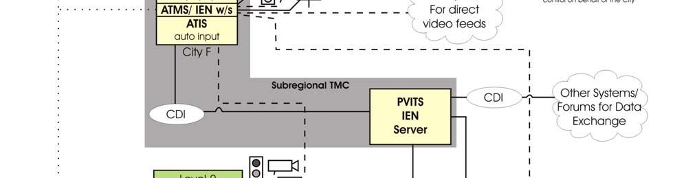
22 Figure 4-3 PVITS Center-to-Center Communications The physical location for the Pomona Valley subregional TMC has not yet been selected, but the subregional TMC will play a key role in the center-to-center communications and other management activities in the subregion. The proposed architecture would enable the local cities and other stakeholders to exchange traffic and traveler information using the Pomona Valley IEN server that will be located at the subregional TMC. In order to exchange data among and between different agencies using the Los Angeles County IENa piece of software, called the Command/Data Interface (CDI), will be required. The CDI provides a translation between each agency s ATMS. The deployment of a CDI enables each agency s traffic signal data to be displayed on the IEN network in a seamless manner. It also provides flexibility in that each agency can have different ATMS systems and the second by second traffic signal data will be transmitted between jurisdictions, and displayed in a uniform manner through the IEN. Figure 4-4, adapted from the IEN System Overview Manual developed by TransCore, depicts the detail at a local level of how the different system components fit together within each level of CTCS/ TMC /14/02


23 Figure 4-4 Local CTCS Interconnect Detail Center-to-field communications will need to be addressed following development of concept designs Market Packages The Market Packages were selected by mapping the selected PVITS area architecture user services to the list of potential National Architecture-defined market packages. This mapping translates user services from functional to physical descriptions. A Market Package often includes capabilities that span more than one user service. Conversely, several user services require multiple Market Packages to implement. The relationship between the PVITS area user services and the resulting matches of market packages is presented in Table 4-2. Table 4-2 PVITS Area User Services Mapped to Market Packages /14/02
24 Market Package User Service Pre-Trip Travel Information En-Route Driver Information Traveler Services Information Traffic Control Incident Management Travel Demand Management Highway-Rail Intersection Emergency Notification and Personal Security Archived Data Function Network Surveillance Probe Surveillance Surface Street Control Regional Traffic Control Incident Management System HOV Lane Management Traffic Information Dissemination Traffic Forecast and Demand Management Electronic Toll Collection Virtual TMC and Smart Probes Parking Facility Management Regional Parking Management Standard Railroad Grade Crossing Advanced Railroad Grade Crossing Railroad Operations Coordination Reversible Lane Management Road Weather Information System HAZMAT Management Broadcast Traveler Information Interactive Traveler Information Autonomous Route Guidance Dynamic Route Guidance ISP-based Route Guidance 21 11/14/02
25 Market Package User Service Pre-Trip Travel Information En-Route Driver Information Traveler Services Information Traffic Control Incident Management Travel Demand Management Highway-Rail Intersection Emergency Notification and Personal Security Archived Data Function Integrated Transportation Management/Route Guidance Yellow Pages and Reservation In-vehicle Signing Intersection Safety Warning Intersection Collision Avoidance Using this mapping along with engineering judgment based on the needs of the subregion, the following market packages have been chosen for implementation in the subregion. Not all of the market packages that were mapped above have been chosen. Network Surveillance; Surface Street Control; Regional Traffic Control; Incident Management System; Traffic Information Dissemination; Traffic Forecast and Demand Management; Standard Railroad Grade Crossing; Multi-Modal Coordination; Broadcast Traveler Information; Interactive Traveler Information; Yellow Pages and Reservation; and Emergency Response Institutional Layer As part of the ITS deployment and the need for interjurisdictional cooperation, operations and maintenance issues will need to be addressed and resolved before implementation. A separate Operations and Maintenance Plan will be prepared in Task 10 of this project. It should be noted while funding for operations and maintenance is limited, some federal funding sources do allow funding of operations and/ or maintenance, but the MTA currently disallows use of these funding sources for operations and/ or maintenance in LA County /14/02
26 The operations and maintenance funding will be a critical issue to running the individual systems as well as maintaining the integration components (communication connections and related equipment) and shared equipment (ATIS and IEN servers) in the subregion. It is important to have clearly defined roles and responsibilities for agencies with respect to the costs of operation and maintenance. Initially the cities will need to agree to operate and maintain the infrastructure. In the future the partner agencies will need Standard Operating Procedures (SOP) and a Memorandum of Understanding (MOU) in order to coordinate efforts and share information and control. Agencies should be bound by an MOU with the SOPs as attachments. Due to the multi-jurisdictional nature of the project, it is important to have well-defined roles and responsibilities for each agency in the subregion. The complex nature of control hierarchy of ITS elements and sharing devices through software functions will also require clearly defined roles and responsibilities. SOPs should be developed that clearly define the roles and responsibilities for each agency in terms of financial, legal and other operational issues. The SOPs and MOU should be updated annually and on an as-needed basis /14/02
27 LIST OF ACRONYMS ACE ATIS ATMS Caltrans CAMS/IEN CCTV DMS ITS LA LACDPW LACMTA LCC MOU NTCIP O&M PC PTZ PVITS TMC TOD UFR UIR UOR USR WWV Alameda Corridor East Construction Authority Advanced Traveler Information System Advanced Traffic Management System California Department of Transportation Los Angeles County Countywide Arterial Management System/ Information Exchange Network Closed Circuit Television Dynamic Message Sign Intelligent Transportation System Los Angeles Los Angeles County Department of Public Works Los Angeles County Metropolitan Transportation Authority Local Control Center Memorandum Of Understanding National Transportation Communications for ITS Protocol Operations and Maintenance Personal Computer Pan, Tilt and Zoom Pomona Valley Intelligent Transportation System Traffic Management Center Time-of-Day User Functional Requirements User Interjurisdictional Requirements User Operational Requirements User Supplementary Requirements National Institute of Standards and Technology Time & Frequency shortwave radio station that broadcast accurate real time 21 11/14/02
28 APPENDI USER SERVICES User Service 1. Travel and Traffic Management Definition 1.1 Pre-trip Travel Information ITS shall include a Pre-Trip Travel Information (PTTI) capability to assist travelers in making mode choices, travel time estimates, and route decisions prior to trip departure. It consists of four major functions, which are, (1) Available Services Information, (2) Current Situation Information, (3) Trip Planning Service, and (4) User Access. Information is integrated from various transportation modes and presented to the user for decision making. 1.2 En-route Driver Information ITS shall include an En-Route Driver Information (DI) function. Driver Information provides vehicle drivers with information, while en-route, which will allow alternative routes to be chosen for their destination. Driver Information consists of two major functions, which are, (1) Driver Advisory and (2) In-vehicle Signing. The potential decrease in traffic may also provide benefits in highway safety, reduced air pollution, and decreased congestion. 1.3 Route Guidance ITS shall include a Route Guidance (RG) function. Route Guidance will provide travelers with directions to selected destinations. Four functions are provided, which are: (1) Provide Directions, (2) Static Mode, (3) Real- Time Mode, and (4) User Interface. 1.4 Ride Matching and Reservation ITS shall include a Ride Matching and Reservation (RMR) function. Ride Matching and Reservation will provide travel users with information on rideshare providers. Three major functions are provided, which are, (1) Rider Request, (2) Transportation Provider Services, and (3) Information Processing. This will also include a billing service to the providers. 1.5 Traveler Services Information ITS shall include a Traveler Services Information (TSI) function. Traveler Services Information provides travelers with service and facility data for the purpose of assisting prior to embarking on a trip or after the traveler is underway. The functions which are included in this capability are Information Receipt and Information Access. This will provide the traveler with a "yellow pages" type of capability /14/02
29 User Service Definition 1.6 Traffic Control ITS shall include a Traffic Control (TC) function. Traffic Control provides the capability to efficiently manage the movement of traffic on streets and highways. Four functions are provided, which are, (1) Traffic Flow Optimization, (2) Traffic Surveillance, (3) Control, and (4) Provide Information. This will also include control of network signal systems with eventual integration of freeway control. 1.7 Incident Management ITS shall include an Incident Management (IM) function. Incident Management will identify incidents, formulate response actions, and support initiation and ongoing coordination of those response actions. Four major functions are provided, which are, (1) Incidents Identification, (2) Response Formulation, (3) Response Implementation, and (4) Predict Hazardous Conditions. 1.8 Travel Demand Management ITS shall include a Travel Demand Management (TDM) function. Travel Demand Management will generate and communicate management and control strategies that will support and facilitate the implementation of TDM programs, policies and regulations. It consists of two major functions, which are, (1) Increase Efficiency of Transportation System and (2) Provide Wide Variety of Mobility Options. 1.9 Emissions Testing and Mitigation ITS shall include an Emission Testing and Mitigation (ETAM) Function. The ETAM function will provide state and local governments with the capability to enhance their air quality control strategies. The ETAM will provide both wide area and roadside emissions monitoring. Information gleaned from ETAM will be used by Traffic Demand Management (TDM) in the Traffic Management Center (TMC) to mitigate pollution and may be provided to enforcement agencies to compel offenders to comply with standards Highway Rail Intersection ITS shall include a Highway-Rail Intersection (HRI) function to control highway and rail traffic in at-grade HRIs. Two sub-services are supported: Standard Speed Rail Subservice which is applicable to light rail transit, commuter rail and heavy rail trains with operational speeds up to 79 miles per hour (MPH); and High Speed Rail Subservice which is applicable to all passenger and freight trains with operational speeds from 80 to 125 MPH. 2. Public Transportation Management 2.1 Public Transportation Management ITS shall include a Public Transportation Management (PTM) function /14/02
30 User Service Definition 2.2 En-route Transit Information ITS shall include an En-Route Transit Information (TI) function. En-Route Transit Information provides travelers with real-time transit and high-occupancy vehicle information allowing travel alternatives to be chosen once the traveler is en-route. It consists of three major functions, which are, (1) Information Distribution, (2) Information Receipt, and (3) Information Processing. This capability integrates information from different transit modes and presents it to travelers for decision making. 2.3 Personalized Public Transit ITS shall include a Personalized Public Transit (PPT) function. 2.4 Public Travel Safety ITS shall include a Public Travel Security (PTS) function to create an environment of safety in public transportation. 3. Electronic Payment 3.1 Electronic Payment Services ITS shall include an Electronic Payment capability. Electronic Payment Services allows travelers to pay for transportation services by electronic means. Four functions are provided, which are, (1) Electronic Toll Collection, (2) Electronic Fare Collection, (3) Electronic Parking Payment, and (4) Electronic Payment Services Integration. 4. Commercial Vehicle Operations 4.1 Commercial Vehicle Electronic Clearance ITS shall include a Commercial Vehicle Electronic Clearance (CVEC) capability. 4.2 Automated Roadside Safety Inspection Vehicle System shall provide the capability for each individual vehicle's or carrier's participation in the process to be on a voluntary basis. 4.3 On-board Safety Monitoring ITS shall include an On-Board Safety Monitoring (OBSM) function, that provides monitoring and warnings of safety problems. Of primary importance is to inform the driver, as soon as possible, of any problem that has been detected. Of secondary importance is notifying the carrier of detected safety problems. Last in importance is the notification of appropriate enforcement agencies. 4.4 Commercial Vehicle Administrative Processes ITS shall include a Commercial Vehicle Administrative Process (CVAP) function consisting of 3 subservices to include Electronic Purchase Of Credentials, Automated Mileage and Fuel Reporting and Auditing, and International Border Electronic Clearance. 4.5 Hazardous Material Incident Response ITS shall include a Hazardous Materials (HAZMAT) Incident Response (HIR) service /14/02
Appendix A: Equipment Packages for St. Louis Regional ITS Architecture
 Appendix A: Equipment Packages for St. Louis Regional ITS Architecture Appendix A: Equipment Packages for St. Louis Regional ITS Architecture... 1 1.1 ATMS01: Network Surveillance - Supporting Equipment
Puget Sound Regional ITS Architecture Update. Why does the region need an ITS Architecture?
 IBI GROUP 801 Second Avenue Suite 1400 Seattle WA 98104 USA tel 206 521 9091 fax 206 521 9095 ibigroup.com Memorandum To/Attention Puget Sound Regional Council Date May 26, 2015 (PSRC) From IBI Group Project
Key Concepts of ARC-IT
 Key Concepts of ARC-IT The Architecture Reference for Cooperative and Intelligent Transportation (ARC-IT) provides a common framework for planning, defining, and integrating intelligent transportation
INTELLIGENT TRANSPORTATION SYSTEMS APPENDIX
 INTELLIGENT TRANSPORTATION SYSTEMS APPENDIX Southern California Association of Governments ADOPTED APRIL 2012 INTELLIGENT TRANSPORTATION SYSTEMS Introduction 1 Existing System Description 1 Existing System
Nashville Area. Regional ITS Architecture. Regional ITS Deployment Plan. June Prepared by:
 Regional ITS Architecture Regional ITS Deployment Plan Prepared by: 069223006 Copyright 2010 by Kimley-Horn and Associates, Inc. All rights reserved. TABLE OF CONTENTS REGIONAL ITS DEPLOYMENT PLAN 1. INTRODUCTION...
ITS Architecture Workshop
 Austin Regional ITS Architecture and Deployment Plan Update ITS Architecture Workshop July 22, 2014 Workshop Overview Welcome and Introductions Presentation and Discussion on the Regional ITS Architecture
Market Package Descriptions
 s Market Package AD1 ITS Data Mart This market package provides a focused archive that houses data collected and owned by a single agency, district, private sector provider, research institution, or other
Gateway Cities Traffic Signal Synchronization and Bus Speed Improvement Project I-5/Telegraph Road Corridor. Deliverable 3.1.2
 Deliverable For: Gateway Cities Traffic Signal Synchronization and Bus Speed Improvement Project I-5/Telegraph Road Corridor Advanced Traffic Management Systems (ATMS) User Requirements Final Version 1.0
Chapter 10. Intelligent Transportation Systems. Ohio Kentucky Indiana Regional Council of Governments Regional Transportation Plan
 Chapter 10 Intelligent Transportation Systems Ohio Kentucky Indiana Regional Council of Governments 2030 Regional Transportation Plan Chapter 10 Intelligent Transportation Systems INTRODUCTION Intelligent
Project Deliverable 4.1.3a Individual City Report - City of Claremont
 Pomona Valley ITS Project Project Deliverable 4.1.3a Individual City Report - City of Claremont Prepared by: May 1, 2002 099017000.1 Copyright 2002, Kimley-Horn and Associates, Inc TABLE OF CONTENTS INDIVIDUAL
Fargo-Moorhead Traffic Operations Center. Project ITS Architecture: Centralized TOC. Version 1.1
 NDSU Dept #2880 PO Box 6050 Fargo, ND 58108-6050 Tel 701-231-8058 Fax 701-231-1945 www.ugpti.org www.atacenter.org Fargo-Moorhead Traffic Operations Center Project ITS Architecture: Centralized TOC Version
Intelligent Transportation System - I
 Intelligent Transportation System - I Lecture Notes in Transportation Systems Engineering Prof. Tom V. Mathew Contents 1 Overview 2 2 Introduction 2 3 ITS user services 3 3.1 Travel and traffic management..........................
State of Qatar ITS Architecture. Customized Service Package Diagrams. Advanced Traffic Management Systems (ATMS)
") State of Qatar ITS Architecture Customized Service Package Diagrams Advanced Systems (ATMS) ATMS01 - Network Surveillance traffic sensor control Ashghal Detectors traffic flow Use NTCIP for Cameras and
State of Qatar ITS Architecture Customized Service Package Diagrams Advanced Systems (ATMS) ATMS01 - Network Surveillance traffic sensor control Ashghal Detectors traffic flow Use NTCIP for Cameras and
ITS Architecture Development
 Personal Information Access Transit Management Traffic Management Communications Fixed Point-to-Fixed Point Communica Vehicle Roadway ITS Architecture Development Systems Engineering For ITS Kickoff Workshop
INTELLIGENT TRANSPORTATION SYSTEMS SUMMARY
 Genesee County Shaping our Transportation Future Together 2035 Long Range Transportation Plan INTELLIGENT TRANSPORTATION SYSTEMS SUMMARY What is an Intelligent Transportation System? An Intelligent Transportation
Congestion Management Process 2013 Update
 Congestion Management Process 2013 Update TRAVEL DEMAND MANAGEMENT AND TRANSPORTATION SYSTEM MANAGEMENT AND OPERATIONS STRATEGIES AND PROJECTS TDM and TSM&O Strategies Commuter Transportation Options Associated
Regional Integrated Multi-Modal Information Sharing (RIMIS) System Project Concept of Operations Executive Summary
 System Project Concept of Operations Executive Summary") Regional Integrated Multi-Modal Information Sharing (RIMIS) System Project Concept of Operations Executive Summary 190 North Independence Mall West Philadelphia, Pennsylvania EXECUTIVE SUMMARY Background
Regional Integrated Multi-Modal Information Sharing (RIMIS) System Project Concept of Operations Executive Summary 190 North Independence Mall West Philadelphia, Pennsylvania EXECUTIVE SUMMARY Background
Executive Summary. October 27, Prepared by: Copyright 2003 by Texas Department of Transportation. All rights reserved.
 State of Texas Regional ITS Architectures El Paso Region Executive Summary Prepared by: October 27, 2003 068510009 Copyright 2003 by Texas Department of Transportation. All rights reserved. TABLE OF CONTENTS
US 75 Integrated Corridor Management
 US 75 Integrated Corridor Management Koorosh Olyai,, P.E. Assistant Vice President Dallas Area Rapid Transit ITS Texas September 5, 2008 Why ICM is needed in the US 75 Corridor DFW 5 th most congested
Draft Regional ITS Deployment Plan
 Regional ITS Architecture and Deployment Plan -Douglas County Region Draft Regional ITS Deployment Plan Prepared by: December 19, 2007 069214001 Copyright 2007 by Kimley-Horn and Associates, Inc. All rights
Executive Summary. March 24, Prepared by: Copyright 2005 by Texas Department of Transportation. All rights reserved.
 State of Texas ITS Architectures and Deployment Plans Permian Basin Region Executive Summary Prepared by: March 24, 2005 068510017 Copyright 2005 by Texas Department of Transportation. All rights reserved.
King County Intelligent Transportation Systems
 King County Intelligent Transportation Systems Signal Synchronization and Beyond Presentation to the Transportation Leadership Forum Department of Transportation February 24, 2005 System Control & Evaluation
A Framework for Developing Integrated ITS Solutions to Improve Traffic Operations
 1. Report No. SWUTC/05/167248-1 4. Title and Subtitle 2. Government Accession No. A Framework for Developing Integrated ITS Solutions to Improve Traffic Operations Technical Report Documentation Page 3.
ITS NEWS. Building Southern California s Goods Movement System for the Next Century. Gateway Cities. I-710 Zero Emissions Freight Corridor
 Building Southern California s Goods Movement System for the Next Century Gateway Cities ITS NEWS Summer 2013 I-710 Zero Emissions Freight Corridor PAGE 4 FRATIS Demonstration Advances PAGE 10 ALSO IN
Intelligent Transportation System - II
 Chapter 49 Intelligent Transportation System - II 49.1 Standards Standards provide some norms and regulations to be followed. Just as the standards are provided by IRC for the signs to be used similar
Regional ITS Deployment Plan
 Regional ITS Architecture and Deployment Plan -Douglas County Region Regional ITS Deployment Plan Prepared by: April 25, 2008 069214001 Copyright 2008 by Kimley-Horn and Associates, Inc. All rights reserved.
Chattanooga Regional ITS Architecture Update Workshop. September 24, 2013
 Chattanooga Regional ITS Architecture Update Workshop September 24, 2013 CHCNGA TPO Boundaries Presentation Overview Overview of ITS ITS Architecture Development Process Existing Regional ITS Architecture
North Dakota Statewide ITS Architecture
 430 IACC Building Fargo, ND 58105 Tel 701-231-8058 Fax 701-231-6265 www.atacenter.org - www.ugpti.org North Dakota Statewide ITS Architecture Final Report March 2005 Prepared for: North Dakota Department
U.S. 101 / San Mateo County Smart Corridor Project
 Department of Transportation District 4 - Traffic Operations October 1, 2013 U.S. 101 / San Mateo County Smart Corridor Project www.dot.ca.gov California Department of Transportation (Caltrans) Overview
APPENDIX A: SHORT-TERM PROJECT DEPLOYMENTS
 APPENDIX A: SHORT-TERM PROJECT DEPLOYMENTS Page 1 of 15 ST-01: I-95 ITS DEPLOYMENT (DE STATE LINE TO AIRPORT) PROJECT DESCRIPTION AND SCOPE: Project will address gaps in ITS device coverage on I-95 from
Amarillo, TX Regional ITS Architecture Customized Market Package Diagrams. Advanced Traffic Management Systems (ATMS)
") Amarillo, TX Regional ITS Architecture Customized Market Package Diagrams Advanced Systems (ATMS) 1 ATMS1 - Network Surveillance TOC Operations Center traffic images traffic flow traffic sensor control
Amarillo, TX Regional ITS Architecture Customized Market Package Diagrams Advanced Systems (ATMS) 1 ATMS1 - Network Surveillance TOC Operations Center traffic images traffic flow traffic sensor control
Greater Yellowstone Rural ITS Priority Corridor Project. Task 5. ITS Vision Working Paper
 Greater Yellowstone Rural ITS Priority Corridor Project Task 5. ITS Vision Working Paper Prepared for the: Montana Department of Transportation and Federal Highway Administration, US Department of Transportation
Connected Corridors: I-210 Pilot Integrated Corridor Management System
 PARTNERS FOR ADVANCED TRANSPORTATION TECHNOLOGY INSTITUTE OF TRANSPORTATION STUDIES UNIVERSITY OF CALIFORNIA, BERKELEY Connected Corridors: I-210 Pilot Integrated Corridor Management System System Integration
Final Congestion Management Process
 Final Congestion Management Process 2015 Prepared by Tulare County Association of Governments 210 N. Church St., Suite B Visalia, California 93291 1. Introduction: What Is Congestion? Congestion can generally
Intelligent Transportation Systems (ITS) Concept of Operations for Freeway Traffic Management
 Concept of Operations for Freeway Traffic Management") Intelligent Transportation Systems (ITS) Concept of Operations for Freeway Traffic Management Prepared for: Minnesota Department of Transportation (Mn/DOT) Prepared by: Athey Creek Consultants and Alliant
Intelligent Transportation Systems (ITS) Concept of Operations for Freeway Traffic Management Prepared for: Minnesota Department of Transportation (Mn/DOT) Prepared by: Athey Creek Consultants and Alliant
UNIT V TRAFFIC MANAGEMENT
 UNIT V TRAFFIC MANAGEMENT TRANSPORTATION SYSTEM MANAGEMENT Transportation System Management (TSM) is a package of short term measures to make the most productive and cost-effective use of existing transportation
End of Queue Warning Systems. Systems Requirements
 End of Queue Warning Systems Systems Requirements December 2015, Revised 2/14/2018 Acknowledgements This document was prepared for Minnesota Department of Transportation s (MnDOT) Systems Engineering to
Architecture Flow Descriptions
 s Architecture Flow alert notification alert notification coordination alert status alerts and advisories archive requests archive status archived data product requests archived data products broadcast
City of Dubuque: Smart Traffic Routing with Efficient & Effective Traffic System (STREETS) Final Report version 1.1
 Final Report version 1.1") City of Dubuque: Smart Traffic Routing with Efficient Final Report version 1.1 June 22, 2018 Submitted to: 17J18 0640 Prepared by Iteris, Inc. Iteris, Inc. i DOCUMENT VERSION CONTROL DOCUMENT NAME SUBMITTAL
City of Dubuque: Smart Traffic Routing with Efficient Final Report version 1.1 June 22, 2018 Submitted to: 17J18 0640 Prepared by Iteris, Inc. Iteris, Inc. i DOCUMENT VERSION CONTROL DOCUMENT NAME SUBMITTAL
10.0 Congestion Management Process
 Livability 2040 Regional Transportation Plan 10-1 10.0 Congestion Management Process 10.1 CMP Summary The identification and evaluation of projects for the Livability 2040 Regional Transportation Plan
Operations in the 21st Century DOT Meeting Customers Needs and Expectations
 Operations in the 21st Century DOT Meeting Customers Needs and Expectations 1 Purpose of this Meeting: Share Thoughts & Discuss Challenges brought about by the changing transportation environment and public
Session 2A (11:45-12:30) Topic Covered Overview Of National Urban Transport Helpline (NUTH) NUTH Applications And Concepts Planning And Design
 Topic Covered Overview Of National Urban Transport Helpline (NUTH) NUTH Applications And Concepts Planning And Design") Session 2A (11:45-12:30) Topic Covered Overview Of National Urban Transport Helpline (NUTH) NUTH Applications And Concepts Planning And Design Considerations National Urban Transport Helpline Overview
Session 2A (11:45-12:30) Topic Covered Overview Of National Urban Transport Helpline (NUTH) NUTH Applications And Concepts Planning And Design Considerations National Urban Transport Helpline Overview
Minnesota Statewide Regional ITS Architecture Version Volume 2: Traveler Information Service Package Area. Prepared by
 Minnesota Statewide Regional ITS Architecture Version 2018 Prepared by December 2018 TABLE OF CONTENTS 1. Introduction... 1 1.1 Statewide Regional ITS Architecture Update... 1 1.2 Volume 2 Traveler Information
APPENDIX A6: OPERATIONAL CONCEPTS BY SERVICE CATEGORY
 APPENDIX A6: OPERATIONAL CONCEPTS BY SERVICE CATEGORY Traffic Management Traveler Information Goods Movement Electronic Payment Toll Collection Fare Payment Public Transportation State-Level Archived Data
Truck Parking Information Management System (TPIMS) Glossary
 Glossary") Truck Parking Information Management System (TPIMS) Glossary AASHTO American Association of State Highway and Transportation Officials is the organization that provides recommendations for a variety of
Truck Parking Information Management System (TPIMS) Glossary AASHTO American Association of State Highway and Transportation Officials is the organization that provides recommendations for a variety of
Executive Summary. February 28, Prepared by: Copyright 2005 by Texas Department of Transportation. All rights reserved.
 State of Texas ITS Architectures and Deployment Plans Lubbock Region Executive Summary Prepared by: February 28, 2005 068510016 Copyright 2005 by Texas Department of Transportation. All rights reserved.
Toledo Freeway Management System
 Detailed Project Plan Advisory Committee Meeting March 5, 2008 Agenda Introductions Background Existing ITS ITS Needs Concept of Operations Project Architecture Proposed System Next Steps Background 1998:
6.0 CONGESTION HOT SPOT PROBLEM AND IMPROVEMENT TRAVEL DEMAND MODEL ANALYSIS
 6.0 CONGESTION HOT SPOT PROBLEM AND IMPROVEMENT TRAVEL DEMAND MODEL ANALYSIS 6.1 MODEL RUN SUMMARY NOTEBOOK The Model Run Summary Notebook (under separate cover) provides documentation of the multiple
Johnson City Regional ITS Architecture Update Kick-off Workshop. October 21, 2014
 Johnson City Regional ITS Architecture Update Kick-off Workshop October 21, 2014 Presentation Overview Overview of ITS ITS Architecture Development Process Existing Regional ITS Architecture Regional Boundaries
NCTCOG Existing and Planned Systems/Deployments NATALIE BETTGER NOVEMBER 27, 2018
 NCTCOG Existing and Planned Systems/Deployments NATALIE BETTGER NOVEMBER 27, 2018 Agenda Regional Planning Activities Organizational Structure Regional TSMO Projects Operations Travel Demand Management
Intelligent Movement of Goods Will Trucks/Trains be able to Operate More Efficiently?
 Intelligent Movement of Goods Will Trucks/Trains be able to Operate More Efficiently? UCLA Lake Arrowhead Symposium October 2008 Lawrence Jesse Glazer FHWA Calif. Division Office Jesse.Glazer@fhwa.dot.gov
The I-80 Integrated Corridor Mobility (ICM) Project
 Project") The I-80 Integrated Corridor Mobility (ICM) Project ITE San Francisco Bay Area Section Presented by Randy Durrenberger February 21, 2013 Presentation Outline Introduction / Background Project Element Strategy
The I-80 Integrated Corridor Mobility (ICM) Project ITE San Francisco Bay Area Section Presented by Randy Durrenberger February 21, 2013 Presentation Outline Introduction / Background Project Element Strategy
Anchorage Regional ITS Architecture Update: Implementationn Plan
 Anchorage Regional ITS Architecture Update: Implementationn Plan June 2015 Revision History Rev. # Date Author(s) QC Notes: Changes & Affected Pages V 0.0 May 27, 2015 L. Jacobson E. Ehlinger Draft for
Database and Travel Demand Model
 Database and Travel Demand Model 7 The CMP legislation requires every CMA, in consultation with the regional transportation planning agency (the Metropolitan Transportation Commission (MTC) in the Bay
Perspectives on Intelligent Transportation and Telematics
 Perspectives on Intelligent Transportation and Telematics Workshop on Intelligent Transportation and Telematic Systems University of California, San Diego Ronald E. Boenau, P.E. Federal Transit Administration
Regional ITS Deployment Plan
 State of Texas Regional ITS Architectures and Deployment Plans Childress Region Regional ITS Deployment Plan Prepared by: August 22, 2003 068510006 Copyright 2003 by Texas Department of Transportation.
INTEGRATED CORRIDOR MANAGEMENT Enhancing personal mobility for all travelers
 INTEGRATED CORRIDOR MANAGEMENT Enhancing personal mobility for all travelers presented by Christopher Francis, Systems Planning Office, FDOT March 26, 2014 VA I-95 Corridor Vision VDOT Secretary/Commissioner
ITS and Air Quality A Critical Look
 ITS and Air Quality A Critical Look April 6, 2005 1.212 Introduction to ITS Professor Joseph Sussman Doctoral Candidate, Technology, Management and Policy Engineering Systems Division, MIT Outline Is ITS
CHAMPAIGN-URBANA-SAVOY REGIONAL ITS ARCHITECTURE
 CHAMPAIGN-URBANA-SAVOY REGIONAL ITS ARCHITECTURE FINAL REPORT March 2005 Prepared by: Champaign-Urbana Urbanized Area Transportation Study A Program of the Champaign County Regional Planning Commission
WHATCOM REGIONAL ITS ARCHITECTURE
 Introduction The Whatcom Regional ITS Architecture This Whatcom Regional ITS Architecture is produced and maintained by the Whatcom Council of Governments. The purpose of the architecture is to compile
Los Angeles Region s Connected/Automated Vehicle Efforts
 Los Angeles Region s Connected/Automated Vehicle Efforts Regional TSMO and NOCoE Webinar Ed Alegre, PTP Los Angeles County Metropolitan Transportation Authority (LA Metro) Los Angeles Region 4,083 square
YAKIMA VALLEY REGIONAL ITS ARCHITECTURE. Yakima Valley Conference of Governments
 YAKIMA VALLEY REGIONAL ITS ARCHITECTURE Yakima Valley Conference of Governments Final Review Version Annual Update Adopted 12/17/2018 0 Table of Contents Executive Summary... 1 1. Introduction... 2 2.
Outline. Overview of ITS. Overview of Regional ITS Architectures. Discussion. What is ITS? ITS Benefits ITS Applications
 Outline Overview of ITS What is ITS? ITS Benefits ITS Applications Overview of Regional ITS Architectures What is a Regional ITS Architecture? Benefits of the Regional ITS Architecture Other Federal FHWA
Funding Intelligent Transportation Systems in the Los Angeles Region
 Funding Intelligent Transportation Systems in the Los Angeles Region 2017 ITS California Annual Meeting Ed Alegre, PTP Los Angeles County Metropolitan Transportation Authority (Metro) Los Angeles Region
Traffic Management System: ITIS
 Traffic Management System: ITIS In line with one of the objectives of the Structural Plan Kuala Lumpur 2020 to improve the management of the Klang Valley's transport infrastructure system, City Hall Kuala
ADOT ITS URBAN FMS. Operate a system that builds and maintains credibility with the motoring public.
 ADOT ITS Introduction Widespread residential and industrial expansions have become as much a symbol of Arizona as the state s famous Saguaro cactus. People from across the country are flocking to Arizona
Iowa Department of Transportation Intelligent Work Zone Deployments
 Iowa Department of Transportation Intelligent Work Zone Deployments SMARTER WORK ZONES TECHNOLOGY APPLICATIONS CASE STUDY The Every Day Counts Initiative (EDC-3) aims to accelerate the deployment of identified,
Executive Summary. January 14, Prepared by: Copyright 2005 by Texas Department of Transportation. All rights reserved.
 State of Texas ITS Architectures and Deployment Plans Wichita Falls Region Executive Summary Prepared by: January 14, 2005 068510013 Copyright 2005 by Texas Department of Transportation. All rights reserved.
Integrated Corridor Management. Integrated Corridor Management Concept Development and Foundational Research
 Integrated Corridor Management Integrated Corridor Management Concept Development and Foundational Research Technical Memorandum Task 2.3 ICMS Concept of Operations for a Generic Corridor April 18, 2006
Connected/Autonomous Vehicles in a
 Connected/Autonomous Vehicles in a Freight Corridor: Implementation Issues and Assumptions presented to ITS 3C Summit 2014 Mobile, AL presented by Cambridge Systematics, Inc. Kenny Voorhies, PE, PTOE September
Strategic Transportation Plan. Presented to: ECO-Rapid Transit Board of Directors Presented by: Gill V. Hicks, Cambridge Systematics, Inc.
 Strategic Transportation Plan Presented to: ECO-Rapid Transit Board of Directors Presented by: Gill V. Hicks, Cambridge Systematics, Inc. June 11, 2014 1 Local Solutions for all Gateway Cities Communities
Distracted Driving Detection System for Work Zones. Systems Requirements
 Distracted Driving Detection System for Work Zones Systems Requirements December 2015 Acknowledgements This document was prepared for the Minnesota Department of Transportation (MnDOT) Systems Engineering
San Francisco Freeway Corridor Management Study (SF FCMS)
") Item 6 Enclosure B Plans and Programs Committee March 17, 2015 San Francisco Freeway Corridor Management Study (SF FCMS) Phase 1 Findings and Recommendations Agenda Item 6 SAN FRANCISCO COUNTY TRANSPORTATION
Item 6 Enclosure B Plans and Programs Committee March 17, 2015 San Francisco Freeway Corridor Management Study (SF FCMS) Phase 1 Findings and Recommendations Agenda Item 6 SAN FRANCISCO COUNTY TRANSPORTATION
New York State Department of Transportation Using ITS Standards for Deployment: Identification, Specification, and Testing. Version 2.
 New York State Department of Transportation Using ITS Standards for Deployment: Identification, Specification, and Testing Version 2.0 Introduction Course Instructors: Consensus Systems Technologies Manny
INNOVATIVE CONCEPTS AND NEW TECHNOLOGIES FOR REGIONAL MULTI-JURISDICTIONAL INTEGRATED TRAFFIC MANAGEMENT
 INNOVATIVE CONCEPTS AND NEW TECHNOLOGIES FOR REGIONAL MULTI-JURISDICTIONAL INTEGRATED TRAFFIC MANAGEMENT Joseph K. Lam, P.Eng., President, Systems Business Perry Craig, P.Eng., Principal, Systems Business
Decision Support Systems for FDOT District 4 TSM&O
 Decision Support Systems for FDOT District 4 TSM&O Melissa Ackert, P.E. District Transportation System Management & Operations Engineer FDOT District 4 Traffic Operations 1 Transportation Systems Management
Minor ITS FORM
 Typical projects that may use this form include the following: Roadway Weather Information System (RWIS), Roadgrip Sensor System, various surveillance or control systems that could functionally be integrated
NYSDOT Task 2.A.2. Best Practices for ITS Standards Specifications. (Draft Final) December 7, 2005
 December 7, 2005") s (Draft Final) December 7, 2005 By Consensus Systems Technologies, Inc. POB 517, 17 Miller Ave. Shenorock, NY 10587-0517 914-248-8466 Prepared for New York State Department of Transportation D015186 PIN
s (Draft Final) December 7, 2005 By Consensus Systems Technologies, Inc. POB 517, 17 Miller Ave. Shenorock, NY 10587-0517 914-248-8466 Prepared for New York State Department of Transportation D015186 PIN
Technical Memorandum #3. ITS Implementation Plan
 Technical Memorandum #3 ITS Implementation Plan Submitted to: New York State Department of Transportation March 2003 Submitted by: PB Farradyne New York, New York ITS Implementation Plan TABLE OF CONTENTS
Regional Intelligent Transportation System Architecture and Deployment Plan
 L A K E W A Y Regional Intelligent Transportation System Architecture and Deployment Plan Prepared by: April 2017 Copyright 2017 by Kimley-Horn and Associates, Inc. All rights reserved. Lakeway Regional
ITS Projects. Page 1 of 5. Project Name Project Status Timeframe Project Description
 NYSDOT-X80599-NYC TIP ID: Traffic Management NYSDOT R11 Advanced Traffic and Demand Management NYSDOT - Island Expy and Brooklyn Queens Expy Travel Time Systems MTA Bridges and Tunnels - VN-03 NYCDOT-X80674-NYC
Functional Requirements
 Missouri Department of Transportation Springfield Regional ITS Architecture Update Prepared for: Project ID: D8ITS-01 Missouri Department of Transportation Traffic Division MODOT DISTRICT 8 OFFICE M.O.
Transportation Pooled Fund Study TPF-5 (231)
") ENTERPRISE Drafmu Transportation Pooled Fund Study TPF-5 (231) Real-Time Integration of Arrow Board Messages into Traveler Information Systems EVALUATION PLAN Prepared by September 2017 Acknowledgements
ENTERPRISE Drafmu Transportation Pooled Fund Study TPF-5 (231) Real-Time Integration of Arrow Board Messages into Traveler Information Systems EVALUATION PLAN Prepared by September 2017 Acknowledgements
ITS Multimodal Initiatives in Virginia HRTO Subcommittee Meeting Hampton, VA, June 11, 2013
 ITS Multimodal Initiatives in Virginia HRTO Subcommittee Meeting Hampton, VA, June 11, 2013 Chris Francis ITS Program Development Manager Operations and Security Division Advancing VDOT s Operations Program
THANK YOU TO ALL THE I-210 PILOT STAKEHOLDERS FOR YOUR COMMITMENT TO THE PROJECT
 Summer 2015 Welcome Samson! Call for Projects Application Recommended For Funding Caltrans is pleased to announce Samson Teshome as the first Corridor Manager under Caltrans innovative reorganization plan.
Proposed Comprehensive Update to the State of Rhode Island s Congestion Management Process
 Proposed Comprehensive Update to the State of Rhode Island s Statewide Planning Program January 2018 Summary Outline of of Action Steps 1. Develop Objectives for Congestion Management What is the desired
Dallas ICM & 511 System. 87 th Annual Transportation Short Course
 Dallas ICM & 511 System 87 th Annual Transportation Short Course October 16, 2013 Agenda Introduction ICM Overview 511 Overview Next Steps / Schedule Q&A What is ICM? The integrated management of freeway,
DuPage County Transportation Coordination Initiative (TCI) FINAL IMPLEMENTATION PLAN
 FINAL IMPLEMENTATION PLAN") DuPage County Transportation Coordination Initiative (TCI) FINAL IMPLEMENTATION PLAN August 2007 DOCUMENT REVISION HISTORY Integration Strategies and Technologies Issue No. Integration Strategies and Technologies
DuPage County Transportation Coordination Initiative (TCI) FINAL IMPLEMENTATION PLAN August 2007 DOCUMENT REVISION HISTORY Integration Strategies and Technologies Issue No. Integration Strategies and Technologies
Congestion Management Plan Update. Public Works and Infrastructure Committee. General Manager, Transportation Services
 PW1.4 STAFF REPORT ACTION REQUIRED Congestion Management Plan 2014-2018 Update Date: December 9, 2014 To: From: Wards: Reference Number: Public Works and Infrastructure Committee General Manager, Transportation
SPECIAL PROVISION Description of Project, Scope of Contract and Sequence of Work
 2004 Specifications CSJ 0027-12-134 SPECIAL PROVISION 000--2823 Description of Project, Scope of Contract and Sequence of Work 1. General. The work to be performed on this project consists of furnishing,
Corpus Christi Metropolitan Transportation Plan Fiscal Year Introduction:
 Introduction: Traffic congestion in the Corpus Christi Metropolitan area is not as much a function of population growth as the function of the increase in single occupant trips. Using census data, the
Los Angeles County Congestion Reduction Demonstration Project
 Los Angeles County Congestion Reduction Demonstration Project frequently asked questions update #1 /august 2008 Los Angeles County Metropolitan Transportation Authority (Metro), California Department of
7.0 TRANSPORTATION MANAGEMENT
 7.0 TRANSPORTATION MANAGEMENT I. Introduction/Current State of Transportation Management in KC Region The Kansas City region has invested considerable effort and resources in the design and implementation
Chittenden County Intelligent Transportation Systems Strategic Deployment Plan
 Communities working together to meet Chittenden County s transportation needs CHITTENDEN COUNTY METROPOLITAN PLANNING ORGANIZATION Chittenden County Intelligent Transportation Systems Strategic Deployment
Task 6 Oahu Regional ITS Architecture & Operational Concept
 Deliverable for: Oahu Regional ITS Architecture Project Task 6 Oahu Regional ITS Architecture & Operational Concept Deliverables VI-2 & VI-3 Final Submitted to: Oahu Metropolitan Planning Organization
III. Regional TSM&O Overview from the 2040 Regional Transportation Plan (Jessica Josselyn, Kittelson & Associates, Inc.)
") Regional Transportation Technical Advisory Committee (RTTAC) Transportation System Management & Operations (TSM&O) Subcommittee Meeting Agenda June 23, 2015 1:30 PM FDOT District Four Headquarters Auditorium
Regional Transportation Technical Advisory Committee (RTTAC) Transportation System Management & Operations (TSM&O) Subcommittee Meeting Agenda June 23, 2015 1:30 PM FDOT District Four Headquarters Auditorium
Purpose and Organization PROGRAM ENVIRONMENTAL IMPACT REPORT. Native American Consultation Workshop
 PROGRAM ENVIRONMENTAL IMPACT REPORT Native American Consultation Workshop A Presentation by the Southern California Association of Governments October, 2015 Purpose and Organization Introduction Draft
Intelligent Transportation Systems Master Plan
 Space Coast Transportation Planning Organization Intelligent Transportation Systems Master Plan April 15, 2014 Version 1.0 Prepared for: Space Coast Transportation Planning Organization 2725 Judge Fran
Policy Research CENTER
 TRANSPORTATION Policy Research CENTER New Approaches to Transportation Management (Task 1) Congestion continues to be a challenge in Texas and throughout the United States, and it is increasing, leading
2004 FEASIBILITY STUDY UPDATE
 Austin-San Antonio Intermunicipal Commuter Rail District 2004 FEASIBILITY STUDY UPDATE December 2004 EXECUTIVE SUMMARY INTRODUCTION Almost 3 million people in Central Texas, living and working between