TRANSIT ALTERNATIVES ANALYSIS OF THE ROUTE 7 CORRIDOR. Background Information Report Appendix
|
|
|
- Jocelyn Summers
- 6 years ago
- Views:
Transcription
1 TRANSIT ALTERNATIVES ANALYSIS OF THE ROUTE 7 CORRIDOR Background Information Report Appendix March 2013 Prepared for: Northern Virginia Transportation Commission Prepared by: Parsons Brinckerhoff
2
3 Transit Alternative Analysis of the Route 7 Corridor Background Information Report Appendix Table of Contents INTRODUCTION... A1 WMATA LEESBURG PIKE 28A/B EVALUATION STUDY... A2 PROPOSED BUS SERVICE AT METRORAIL SILVER LINE STATIONS: PHASE 1 AND 2.. A4 VIENNA PLANNING DISTRICT... A6 TYSONS CORNER URBAN CENTER... A9 SUPER NOVA TRANSIT AND TDM VISION PLAN... A15 ARLINGTON MASTER TRANSPORTATION PLAN, TRANSIT ELEMENT... A17 ALEXANDRIA TRANSPORTATION MASTER PLAN, TRANSIT ELEMENT... A19 I-66 TRANSIT/TRANSPORTATION DEMAND MANAGEMENT (TDM) STUDY (2009)... A21 MWCOG BUS PRIORITY HOTSPOTS STUDY... A23 MCLEAN PLANNING DISTRICT... A24 MARK CENTER TRANSPORTATION STUDY... A28 JEFFERSON PLANNING DISTRICT... A38 FAIRFAX COUNTY FY 2012 CAPITAL IMPROVEMENT PLAN... A42 FAIRFAX COUNTY COMPREHENSIVE PLAN, 2011 EDITION... A44 TYSONS CORNER DRAFT CIRCULATOR STUDY... A47 COUNTYWIDE TRANSIT NETWORK STUDY... A57 BRADDOCK NEIGHBORHOOD PLAN... A62 BEAUREGARD SMALL AREA PLAN... A67 BAILEYS PLANNING DISTRICT... A77 ALEXANDRIA TRANSPORTATION MASTERPLAN REVIEW... A80 ALEXANDRIA WATERFRONT SMALL AREA PLAN... A86 I-95 INTEGRATED CORRIDOR MANAGEMENT SYSTEM... A88 I-66 MULTIMODAL STUDY, INSIDE THE BELTWAY... A89 SOUTH SIDE MOBILITY STUDY... A90 PRTC TRANSIT DEVELOPMENT PLAN ( )... A91 Page i
4
5 Background Information Report Appendix INTRODUCTION This appendix contains the summaries of the plans and studies affecting the Route 7 study area. The inclusion of these summaries is to help the background information report serve as a central repository of data gathered and display graphics and charts that speak to the transportation and land use changes proposed within each document. Page A1
6 WMATA Leesburg Pike 28A/B Evaluation Study WMATA LEESBURG PIKE 28A/B EVALUATION STUDY Introduction The WMATA 28A/B Evaluation Study was undertaken to assess the viability of implementing an express bus variant to the existing 28A/B line, which is the only transit service covering more than a short distance of Route 7. While the ridership of the 28A & B has been strong (over 5,000 daily trips at the time of the study), the line was plagued by traffic volumes and frequent stops, often stretching one-way travel times to over 90 minutes. It was hoped that a limited-stop service on Route 7 could provide a faster, more reliable trip for existing 28A/B riders, as well as attracting approximately 400 new weekday riders. Plan Recommendations The areas of greatest concern and opportunity, identified through the public process, included the following: The existing schedule was reported to be insufficient, with poor weekend and late night service. Because of the long scheduled headways, poor reliability was more significant to riders. Travel time was mostly an issue at Seven Corners and near the West Falls Church Metro. Few people were interested in the time from one end of the route to another. Certain bus stops were extremely crowded in the mornings, mostly at transfer locations. Getting to these stops was sometimes difficult when sidewalks were not available nearby (like crossing the Beltway). This service evaluation resulted in the 28X express variant of the Rte 7 Leesburg Pike line (implemented 2010), and the elimination of the 28B variant. The current 28A now follows a route that is a consolidation of the old A & B route options in Alexandria, and the route in Tysons has been simplified as well. The 28X, which runs in both directions during the AM & PM weekday peaks, serves only 17 stops between Tysons and Skyline/Mark Center. Implications for Route 7 Transit Alternatives Analysis The 28A/B Evaluation Study illustrated several of the core issues for the Route 7 corridor, most notably that the travel patterns are marked by a wide variety of short to medium trips connecting various points along the corridor, with relatively few trips covering the entire length of the corridor. The 28X service as implemented established what could be seen as a corridor within a corridor connecting the density centers of Tysons & Skyline/Mark Center. Page A2
 and stop enhancement recommendations included for Route 7 as part of the Priority Corridors Network Plan.")
7 WMATA Leesburg Pike 28A/B Evaluation Study Figure A 1: Desire lines from 2008 origin-destination study of 28 Line passengers (from MWCOG The Study also laid the groundwork for the transit signal prioritization (TSP) and stop enhancement recommendations included for Route 7 as part of the Priority Corridors Network Plan. The ridership increase expected from the 28X service has thus far not yet materialized, with weekday ridership on the 28A/X averaging 5,002 in It should be noted that the economic downturn led to ridership drops system-wide. Page A3
8 Proposed Bus Service at Metrorail Silver Line PROPOSED BUS SERVICE AT METRORAIL SILVER LINE STATIONS: PHASE 1 AND 2 Introduction The technical memorandum developed for WMATA describes the bus transit service proposed at Dulles Corridor Metrorail Stations in Phase 1 and Phase 2. The timeframe of the improvements is from 2009 to 2017, which is the span covered by the reports used as input for the memo. The Silver Line will provide service from East Falls Church to Washington Dulles International Airport and Ashburn. It will serve major employment centers such Tysons Corner, Reston- Herndon, and Dulles Airport, and provide connections to Washington, DC. The purpose of the technical memorandum is to identify the bus service proposed by Fairfax Connector, WMATA, Loudoun County, and PRTC to coincide with Phases 1 and 2 of the Silver Line. Anticipated short- and long-term improvements The technical memo identifies two horizon dates, 2014 and 2017, which are the completion dates for Phase 1 and Phase 2 of the Metrorail Silver Line, respectively. The Silver Line is a 23- mile extension of the existing Metrorail system from East Falls Church to Washington Dulles International Airport and Ashburn and will include 11 new stations. Phase 1 will provide service from East Falls Church to a station at Wiehle Avenue (east of Reston) and will also include four new stations in Tysons Corner. The memo identifies the bus service proposed by Fairfax Connector, WMATA, Loudoun County and PRTC during Phase 1 and Phase 2. During Phase 1, Fairfax Connector proposes several new routes and modifications to existing routes and schedules to serve the new stations. Fairfax Connector also proposes to eliminate existing routes during Phase 1. WMATA identified various routes that will be modified to start and end service at selected new stations. Existing routes will also undergo schedule changes. Loudoun County proposed new routes that will service the new stations, and other existing local and commuter routes will be modified to serve the new stations. PRTC also has plans modify existing routes to service the new stations. Phase 2 of the Dulles Metrorail project is expected to begin service in 2017 and extends the Silver Line from Wiehle Avenue to Ashburn in Eastern Loudoun County and adds six additional stations. Many of the proposed bus improvements that will be implemented during Phase 1 are planned to be altered to accommodate the new Phase 2 stations. During Phase 2, Fairfax Connector proposes new routes that will serve the new stations and plans to reroute and modify the span of service and frequency of some of the routes in Phase 1. WMATA proposes to eliminate a route during Phase 2 and modify the span of service and frequency of several routes. Loudoun County plans to plans to reroute and modify the span of service and frequency of some of the routes added in Phase 1. PRTC plans to implement new routes that will connect to the new Phase 2 stations. Page A4
9 Short Term Transit Alternatives Analysis of the Route 7 Corridor Proposed Bus Service at Metrorail Silver Line Plan Recommendations Fairfax Connector, WMATA, Loudoun County, and PRTC currently provide service in the Dulles corridor. Proposed new and modified service will serve the new Phase 1 and Phase 2 stations. Phase 1 of the Dulles Metrorail Project is currently under construction. It is assumed that the proposed bus service will be implemented near the completion of Phase I in 2014 and recommended service for Phase 2 will be implemented near the completion of Phase 2 in The memo does not identify recommendations that are currently implemented. It is assumed that the recommendations will be implemented closer to the completion of Phase 1 and Phase 2. Table A 1: Key Recommendations Category of Bus Enhancement Improvement to Local Bus Service Improvement to Metrobus Bus Service Impact on WMATA Fleet Size Rec. Pass. Amenities / Impact on WMATA Facilities Rec. ITS New Bus Routes Modified Bus Routes Service to new Metrorail station Increased frequency Service to new Metrorail station Service to new Metrorail stations Increased frequency Service to new Metrorail stations None; new buses required are for local agencies None None None None None Page A5
10 Vienna Planning District VIENNA PLANNING DISTRICT Introduction The Vienna Planning District is located in the central northeast section of the County. The Vienna Planning District is predominantly comprised of residential neighborhoods with singlefamily detached and attached dwellings. The district includes some of the most developed sections of the County and covers about 16.7 square miles. A mix of higher density residential uses is concentrated along the Lee Highway (Route 29) and Arlington Boulevard (Route 50) corridors. Medium density townhouse developments are located in areas south of Route 123 with some concentration in the area between Lee Highway and Route 50. A 75-acre industrial park is located in the Town of Vienna adjacent to the County line. There are several neighborhood shopping centers and one community shopping center, combined with scattered strip commercial uses, located in the Planning District. Vienna Transit Station Area The Vienna-Fairfax-GMU Metro station is located in the median of I-66, west of Nutley Street. The station is connected to parking and feeder bus service north and south of I-66 via enclosed pedestrian bridges above the highway. Access roads extend both to the north and south of I-66 from Nutley Street to Blake Lane. Vehicles proceeding east on I-66 may take an off-ramp to the station, use the station, and then proceed to the westbound lanes of I-66 without having to enter the I-66 and Nutley Street interchange. These Metrorail stations provide the opportunity for nonautomobile dependent development to occur in a manner that is compatible with the existing nearby land uses. Recommendations Parking In order to promote the use of mass transit, parking for the multi-family and office uses should not exceed a ratio that is 10% higher than the minimum Zoning Ordinance requirements, not including parking spaces allocated to support TDM programs such as car sharing (e.g. FlexCar/ZipCar), car/van pool and fleet vehicles, shuttle vans/buses and the like. In order to be transit and pedestrian friendly, parking structures should generally be internal to the site and not oriented towards the Metro Station. Transportation It is essential that the impacts of the development allowed under this option be offset through a combination of additional roadway and transit capacity, roadway and pedestrian circulation and access improvements, and effective transportation demand management (TDM) measures. Capacity, Circulation, and Access Detailed traffic impact analyses should be done at selected intervals (identified at time of rezoning or other zoning evaluation) to determine the improvements required to mitigate the impacts of the proposed development on the transportation system. Page A6
11 Vienna Planning District Transportation Demand Management (TDM) A transportation demand management (TDM) program should be provided that encourages the use of transit (Metro and bus) and high occupant vehicle commuting modes, and that utilizes measures to reduce automobile trips. A variety of TDM measures can be implemented to help achieve the expected trip reduction. These measures could include the following: Alternative Transportation Services Shuttle Bus(es) Vanpools Shared vehicles Telecommuting Concierge services Incentives to live where you work Contacting other building/development associations to combine and coordinate TDM measure Support Facilities/Programs On-Site Transportation Coordinator Ridematching Services Preferred HOV Parking Locations Flexible Work Hours Financing incentives for reduced vehicle ownership Pricing Programs Parking Management/Pricing Programs Subsidies for Use of HOV Modes, such as MetroCheck Page A7

12 Vienna Planning District Figure A 2: Vienna Planning District Overview Page A8
13 Tysons Corner Urban Center TYSONS CORNER URBAN CENTER Introduction Tysons, with its large concentration of office and retail development, is well positioned to take advantage of the coming of Metrorail s Silver Line. This line will run from the East Falls Church station and ultimately extend beyond the Washington Dulles International Airport into Loudoun County. Four Metro stations are planned to open in the Tysons Corner Urban Center by 2014: Tysons East, Tysons Central 123, Tysons Central 7, and Tysons West. The arrival of Metrorail service provides an opportunity to transform Tysons yet again, from an edge city into a true urban downtown for Fairfax County. The remade Tysons should provide a better balance of housing and jobs, a transportation system that includes facilities for pedestrians, bicyclists and motorists, and a green network that links existing stream valley parks with open space and urban parks located throughout the area. Vision for Tysons Transportation Public Transportation In order for Tysons to develop into a great urban center, public transportation needs to serve an increasingly higher percentage of trips over time. Metrorail is the most significant public transportation improvement and is expected to carry the majority of public transportation trips in the near term. Metrorail will serve passengers travelling to Tysons from the Dulles Corridor to the west and from Arlington and the District of Columbia to the east; both directions contain significant residential centers. It will also serve residents of Tysons travelling to these areas, which are also major employment areas. While Metrorail is necessary for Tysons to develop into an urban center, it is not sufficient to support development at the Comprehensive Plan level. Other regional high quality public transportation services, such as express bus routes serving Tysons from the regional network of HOV and HOT lanes, are needed. In addition, two urban rail transit corridors, with significant residential centers, need to connect to Tysons. A system of circulators is necessary to connect other areas of Tysons to the Metrorail stations and to provide a robust internal transit system within Tysons. Finally, local bus routes will continue to serve Tysons and these routes connect nearby communities to Tysons for trips that are generally shorter than the trips served by the regional rail and bus network. Public Transportation Goals To support the level of development in Tysons forecasted for the year 2050, it is necessary for transit to achieve a 31% mode share of all person trips to, from and within Tysons Corner during peak periods. To be able to achieve the increase in transit use, the following transit services should be provided for Tysons Corner. Page A9

14 Tysons Corner Urban Center The extension of Metrorail in the Dulles Corridor to Loudoun County Express bus/brt routes on I-66, I-95/I-495 and Leesburg Pike east of Tysons Corner A Circulator System serving Tysons Expanded local bus service Additional BRT routes and other supporting services including park-and-ride and feeder bus routes to rail stations. At least two additional urban rail corridors with substantial TOD development; for example, a more direct connection to a future Orange Line extension and a Beltway rail line to Montgomery County, both having TOD at their stations. Table A 2: Transit Mode Share at Increasing Levels of Development Metrorail The extension of Metrorail into the Dulles Corridor, with four stations located within Tysons, will offer mobility and accessibility from many portions of the region to Tysons. More importantly, Metrorail will provide a necessary alternative to the automobile in order for Tysons to retain its economic viability and achieve its full potential. The Metrorail service will also provide greater opportunities for people to reside in Tysons and use transit for much of their daily travel. Express Bus Service/Bus Rapid Transit (BRT) The opening of the Beltway High Occupancy Toll (HOT) lanes with three new connections to Tysons provides an opportunity to serve Tysons with a significant express bus network extending on the regional HOV/HOT network to destinations such as the I-95 corridor and the I- 66 corridor. These corridors are identified as Enhanced Public Transportation Corridors in the Fairfax County Transportation Plan. This designation indicates that major public transportation facilities could be added to these corridors based on a comprehensive alternatives analysis at some point in the future. Along with Metrorail and light rail, Bus Rapid Transit and express bus services are potential options. Serving Tysons with robust express bus service is needed to complement Metrorail. Page A10
15 Tysons Corner Urban Center These express buses are likely to use the Metrorail stations as terminal points and having passengers transfer there to an internal Tysons circulation system just like Metrorail passengers. System of Circulators In order to increase the use of Metrorail for trips to, from and within Tysons, it is essential to provide a system of transit circulators. The circulators therefore will have two main functions: To provide quick and convenient access for Metrorail passengers to and from locations within Tysons but beyond walking distance from the Metrorail stations To provide a quick and convenient way to travel within Tysons Local Bus Service When the Metrorail extension opens, the local routes are expected to be realigned to provide better service to the new Metrorail stations, while other existing routes may be eliminated or replaced by modified routes or the extended Metrorail service. Bus service frequencies will also be modified for other routes to achieve consistency with new transit service in the corridor, to better coincide with Metrorail headways and to reduce duplication of service where it exists. Multimodal Transportation Hubs Multimodal Transportation Hubs, strategically placed close to Metrorail and circulator stations and/or other retail, employment and residential centers, are needed to allow flexibility in trip making within Tysons. Multimodal transportation hubs are envisioned to provide alternative modes of transportation and transportation services including: Transit (rail and/or bus) Bike sharing Car sharing Other personal transportation devices Taxis Some transportation services such as bike sharing, car sharing, and other personal transportation devices can be provided by a retail service. Page A11
16 Tysons Corner Urban Center District Recommendations Tysons West Tysons West is a gateway to Tysons from Route 7 and the Dulles Airport Access Road and Toll Road. This area of industrial uses, car dealerships and offices is envisioned to transform into a new transit-oriented, mixed use destination with special emphasis as an arts and entertainment center. Along Route 7, a transformed streetscape will create a wide tree-lined boulevard with inviting street level facades below high-rise buildings. This redesign should result in a calming of traffic through the area while maintaining the roadway capacity of Route 7. On the southeast end of the district, office buildings along Route 7 create a strong business environment. People should be able to move easily back and forth between the Tysons Central 7 and Tysons West TOD Districts to take advantage of both transit stations and the supporting services planned for the ground floor of the office buildings and future residential buildings in this area. Redevelopment Option This subdistrict is envisioned for substantial redevelopment to create a mixed use TOD with significant office, residential and retail components, as well as arts and entertainment uses. To achieve this vision, development proposals should address the Areawide Recommendations, and provide for the following. Public facility, transportation and infrastructure analyses should be performed in conjunction with any development application. The results of these analyses should identify needed improvements, the phasing of these improvements with new development, and appropriate measures to mitigate other impacts. Also, commitments should be provided for needed improvements and for the mitigation of impacts identified in the public facility, transportation and infrastructure analyses, as well as improvements and mitigation measures identified in the Areawide Recommendations. North Subdistrict The North Subdistrict is comprised of about 125 acres and is bounded by the Dulles Airport Access Road and Toll Road on the north, Route 7 on the southwest, and the Tysons Central 7 and North Central Districts on the southeast. Redevelopment Option: The subdistrict is envisioned for substantial redevelopment to mixed use with office being focused along Route 7 and adjacent to the Dulles Airport Access Road and Toll Road. Urban residential neighborhoods should be provided and will enliven the vibrancy of this mixed use district. Other land uses should include hotels, arts and entertainment, retail and support services. A series of urban parks should be provided and be linked by the street grid; this green network will provide places for people of all ages to walk and enjoy parks and open space. Page A12
17 Tysons Corner Urban Center District Tysons Central 7 Tysons Central 7 District has two subdistricts, separated by Route 7. The North Subdistrict is envisioned to be a vibrant 24-hour mixed use center with residential, retail, and hospitality uses, as well as a high concentration of office space. The South Subdistrict is envisioned as a civic center with a great public space and a significant new public building or buildings. The South Subdistrict will also include a mix of public, residential and commercial uses. The transformation in the South Subdistrict will be influenced by redevelopment that comes with the extension of Boone Boulevard. The northwestern portions of both subdistricts provide connectivity to the Tysons West District by means of the grid of streets, which provides streets parallel to Route 7. Along Route 7, a transformed streetscape will create a wide tree-lined boulevard on either side of the at-grade Metro station. This redesign will result in a calming of traffic through this office area while maintaining the capacity of Route 7. The streets leading to and from Tysons Central 7 will be pedestrian-friendly, encouraging people to walk and bike and leading people to the civic center and the business areas of the district. Redevelopment Option: A Common Green type urban park of at least one acre in size should be provided in the area between Route 7 and Greensboro Drive Tysons Central 123 Tysons Central 123 is home to over half of Tysons entire retail floor area. Building upon this strength by providing street-front, ground floor retail and more entertainment uses, this district is envisioned to remain the region s signature shopping destination. The vision for this district, however, goes beyond its current retail emphasis to create a vibrant mixed use area. Running through the heart of Tysons Central 123 will be improved Routes 123 and Route 7. Both will be redesigned as pedestrian friendly, tree lined boulevards, with greater connectivity between Tysons 123 and Old Courthouse South. The area is planned and approved for transit-related mixed use development with approximately 6,800,000 square feet. Tysons East Tysons East serves as a signature gateway for those coming to Tysons from the east. The defining focus of Tysons East will be Scotts Run Stream Valley Park, which is envisioned to be a great urban park and natural resource amenity surrounded by a mix of uses including office, residential, hotel, support retail and services. In addition, the area is a good location for institutional and public uses, such as educational and recreational facilities. West Side The West Side District is developed with two residential neighborhoods and includes the Old Courthouse Spring Branch Stream Valley Park as a key feature. This stream valley park, along with Freedom Hill Park and Raglan Road Park, result in about half of the land in this district being park land. Page A13
18 Tysons Corner Urban Center District Old Courthouse Located between Route 7 and the edge of Tysons (south of Old Courthouse Road), the Old Courthouse District will have smaller scale office buildings and residential developments than TOD districts and will serve as a transition area between the Tysons Central 123 District and the neighboring communities. With additional infill and redevelopment, portions of the Old Courthouse District will evolve into a neighborhood that supports an active 24-hour environment where people go to restaurants or shopping after work. Residential development will become a dominant use in most subdistricts, which will create the sense of community throughout this district. As Route 7 runs through the Old Courthouse District, street treatments will calm traffic and soften its negative visual impact from the businesses and residents fronting the arterial. Active storefronts, street furniture and other pedestrian amenities will provide for a pleasant walking experience. Page A14
19 Super NOVA Transit and TDM Vision Plan SUPER NOVA TRANSIT AND TDM VISION PLAN Introduction The Vision Plan will evaluate current transit service and transportation demand management (TDM) programs; existing and future land use, population, and employment conditions; travel patterns and trends; and projected travel demand as a basis for the development of a multihorizon vision for transit and TDM in the super region. The multi-horizon vision plan will focus on the near-, mid- and long-term periods between today and The Super NoVA Transit and TDM Vision Plan will recognize the purposeful connection between land use and transportation, today and into the future. The Vision Plan will identify realistic, but visionary, strategies for enhancing people's mobility through non-single occupant auto means under existing and future conditions. Planning efforts of the study will culminate in the development of recommendations for a wide range of transit modes as well as transportation demand management programs and infrastructure. The Vision Plan will identify a wide range of transit mode and transportation program enhancements for: Local, express, rapid, and priority bus; Fixed guideway transit-streetcar, light rail transit, heavy rail transit, commuter rail, and intercity passenger rail; and, Transportation demand management. The Draft goals for the project are to Create a regionally coordinated comprehensive transit and TDM vision that supports increased mobility and provides greater transportation choice in the northern part of Virginia Coordinate the transit and TDM vision with local and regional land use plans Address short- and long-term needs of people traveling in Virginia and from Maryland, West Virginia and Washington, D.C., through and into Northern Virginia Support economic growth and prosperity in Virginia; and, Facilitate a robust public outreach program that will meaningfully involve the public, government. Short-term and Long-term Improvements The study has combined land use, population, and employment projections and four regional models into one super-regional trip table that allows them to analyze demand between super zones (person-trip connections). The study will make recommendations at three levels beginning with the broadest regarding what improvements should be made to assist WMATA in meeting core capacity demands. The second level will identify corridors in broad terms such as Urban High, Urban Medium, Suburban High, and Suburban Medium and look at the tradeoffs of potential services, such as LRT vs. HRT, and Commuter Rail vs. Commuter Bus. The third level will identify individual corridors and classify their potential demand level and the conditions to support various transit services in that corridor. The vision for transit in Northern Virginia supports existing plans namely high-capacity transit along the Route 7, Van Dorn/Beauregard and Duke Street corridors, as well as a high-capacity Page A15

20 Super NOVA Transit and TDM Vision Plan transit network throughout Fairfax County. It also supports locating intermodal hubs strategically located throughout Northern Virginia, including in the areas of Tysons and Falls Church. Figure A 3: Recommended Higher Capacity Transit Network Page A16
21 Arlington MTP, Transit Element ARLINGTON MASTER TRANSPORTATION PLAN, TRANSIT ELEMENT Introduction This Transit Element provides implementation actions to maximize the potential of the existing transit system while the County makes improvements to local and regional transit service and implements new transit service such as streetcar or Bus Rapid Transit (BRT). The Arlington Master Transportation Plan envisions public transit becoming an even more important part of the transportation system. The Transit Element covers the timeframe from 2009 to Purpose, Goals and Objectives: Provide high-quality transportation services. Move more people without more traffic. Promote safety. Establish equity. Manage effectively and efficiently. Advance environmental sustainability. Short-term and Long-term Improvements Three categories of PTN routes are recommended: Primary Routes, Candidate Primary Corridors, and Major Express Bus Corridors. While implementations of all elements of this plan are recommended, the highest priority is the establishment of the Primary Routes. Primary Routes operate along the corridors that the County s General Land Use Plan has identified for higher-density development. Candidate Primary Corridors serve low- to medium-density areas (based on land use) and have some long-term potential to become part of the Primary Routes. In addition to the PTN routes, express bus corridors could operate along arterial streets and limited-access highways and make limited stops to provide service between residential and key employment locations. Develop a Primary Transit Network (PTN) of high-frequency and quality transit services along major corridors to encourage a low-auto-usage lifestyle and higher all-day patronage. The PTN should extend beyond the established Metrorail corridors and include new surface transit services, such as streetcar and bus rapid transit. Transit services should operate at 15-minute intervals or better every day for about 18 hours. Short-term priorities include increased frequency of service along Glebe Road and physical improvements to enhance transit travel speed and reliability in all PTN corridors. Operate a Secondary Transit Network (STN) of bus and paratransit services that improves access to Arlington neighborhoods, commercial centers, community facilities and to the primary transit corridors. The local transit services, such as bus routes, circulators and paratransit should meet service frequency standards of at least two trips per hour during weekdays and at least one trip per hour at night and on weekends, while operating in a cost efficient manner. Page A17
22 Arlington MTP, Transit Element The Transit Element also identified several actions and measures designed to support the expansion of previously identified transit services that could impact Metrobus services including the following: Implement a universal payment system for all transit services. Conduct regular surveys of bus stop utilization to determine needs for service and amenity upgrades and determine if any stops should be consolidated or relocated to improve bus operating efficiency. Implement a hierarchy of service improvements such as increased span and service frequency, traffic signal prioritization, bus stop amenity upgrades, stop consolidation and express bus options, enhanced payment options and technology upgrades that will improve service efficiency and promote increased ridership levels. Construct a garage and maintenance facility adjacent to the WMATA Four Mile Run garage with sufficient capacity to allow for expected growth in the ART vehicle fleet. Page A18
23 Alexandria MTP, Transportation Element ALEXANDRIA TRANSPORTATION MASTER PLAN, TRANSIT ELEMENT Introduction This City of Alexandria Transit Concept outlines a progressive vision for the future of travel throughout the City of Alexandria with a system of innovative transit vehicles operating along three primary transit corridors within secure rights-of-way dedicated exclusively to transit use. This plan is an innovative vision for the development of clean, efficient, enjoyable transit services that travel in dedicated lanes, enhancing mobility throughout the City and region for commuters, residents and visitors alike. The Transit Element covers the timeframe from 2008 to Purpose, Goals and Objectives: Goal: Ensure that people can travel into, within and out of the City of Alexandria by providing a mass transit system that combines different modes of travel into a seamless, comprehensive and coordinated effort. Objective: A reliable and convenient mass transit system integrated with surrounding land uses and existing transportation connections that offers travel time savings and an enjoyable transit experience for its riders, featuring advanced technology and passenger amenities. Goal: Ensure that people can travel into, within and out of the City of Alexandria by providing transportation choices that combine different modes of travel into a seamless, comprehensive and coordinated transportation system. Corridors / Activity Centers: Corridor A: Corridor A is a primary link between the Pentagon to the north and Ft. Belvoir to the south. Corridor B: Corridor B is an east-west corridor along the southern border of the City between King Street/Eisenhower East Metro stations and Fairfax City. Corridor C: Corridor C provides a key link between Kingstowne and points south with the Pentagon. Short-term and Long-term Improvements The City envisions a system of innovative transit vehicles operating along three primary transit corridors within secure rights-of-way dedicated exclusively to transit use. The City s new transit system will be linked through circulator shuttles as well as intermediate transit services offered via DASH that complete the transit network, providing access to all residents who are not located in direct proximity of the newly designated transit corridors. The entire transit network will be linked by way of Smart Stops, Shelters and Stations located along all transit routes. These smart facilities will provide varying levels of passenger amenities such as wireless access, coffee, ticket machines and information kiosks. All of these facilities will provide real-time transit information, bicycle parking, shelter and seating for transit users. The study makes no recommendations regarding Metrobus-targeted network enhancements. Page A19
24 Alexandria MTP, Transportation Element A meeting was held on April 27 th, 2012 at WMATA offices with representatives from Arlington, Alexandria, and DRPT to review applicable local plan summaries. The following bullets summarize the feedback received regarding the Alexandria TMP: Alexandria staff noted that they have completed a corridor study on Corridor C (Van Dorn-Beauregard) and have received funding to prepare an AA for it. In May the Transportation Commission approved feasibility studies for Corridors A and B. They also noted that a transitway south of Braddock Road Metrorail station will no longer be consider as part of Corridor A. In addition, the city has 2.2 cents from property tax to implement transportation improvements throughout the city. They have a ten year plan for utilizing the funds, including the exclusive transitway on Van Dorn- Beauregard which they hope is operational by There is also funding for DASH expansion but not all of what is in the TDP. Page A20
25 I-66 Transit/TDM Study I-66 TRANSIT/TRANSPORTATION DEMAND MANAGEMENT (TDM) STUDY (2009) Introduction The scope of the study involves developing a plan for short- and medium-term transit and TDM service improvements in the I-66 corridor between Haymarket and Washington, D.C. and to be positioned to provide input into the restart of the Virginia Department of Transportation (VDOT) I-66 Multimodal Transportation Environmental Study. The study improvements are recommended for implementation by the horizon years of 2015 and The purpose of the I-66 Transit/TDM Study was to identify more transportation choices through transit service and TDM program enhancements to increase mobility in the corridor. Recommendations for enhancements to transit services and facilities would improve service levels, capacity, and service quality without precluding the future extension of the Metrorail Orange Line. The objectives for the study include examining and recommending transit operational concepts and capital investments that would increase mobility and connectivity in the corridor; developing recommendations for enhancing TDM programs and program effectiveness to reduce single-occupant vehicular travel in the corridor; and developing recommendations for actions in the short and medium timeframes. Short-term and Long-term Improvements The improvements in the study are recommended for implementation by the horizon years of 2015 and The study provides infrastructure, program, and service recommendations for transit and TDM in the corridor. Priority bus stations and access ramps are recommended for construction by 2015 and expansion by The stations would decrease transfers and the ramps would improve bus access and departure from the station. New and expanded park and ride lots are recommended by 2015 to increase parking availability for transit users and encourage ridesharing. Some lots are recommended for expansion by The study proposes the implementation of a two-foot wide painted buffer by 2015to increase the visibility of the HOV lane and discourage the frequent lane changes that currently slow traffic in the I-66 HOV lane. Recommended transit service includes modified existing PRTC routes and a new PRTC-operated priority bus route. Additional transit service includes three new WMATAoperated bus routes, one priority and two Metrobus Express. The modified and new routes are recommended for implementation by 2015 and increase frequency for some routes by The study recommends that by 2015, the following TDM elements be implemented: enhanced corridor marketing for TDM and transit; incentives for vanpool drivers; corridor-specific startup carpool incentives; increased rideshare operational support; expanded carsharing at priority bus activity nodes; bike hubs/storage at priority bus activity nodes; evaluation of the TDM program; enhanced Virginia vanpool insurance pool; and, added financial incentives for telework participation. The improvements recommended for implementation by 2030 includes: incentives for commuters traveling to/from Northern Virginia using non-sov mode; vanpool accessibility to bus-only infrastructure on I-66 corridor; financial assistance for vanpool van lease or purchase; establishing a flexible vanpool network that permits part-time ridership and flexibility for full-time Page A21
26 I-66 Transit/TDM Study riders; public agency contribution to employer-provided SmartBenefit transit/vanpool subsidies; and, Self-serve kiosks or staffed commuter stores at I-66 Priority Bus stations. The study recommends three new WMATA-operated priority bus routes by 2015 and increase frequency for one of the routes by The routes would have limited stops and operate in any available HOV facilities along the corridor in order to improve travel speeds. The recommended routes includes a I-66 Priority Bus route operating between Centreville and the D.C. core, and U.S. 29 Metrobus Express and U.S. 50 Metrobus Express routes that would operate between Fair Oaks and Ballston/D.C. Eight priority stations that were recommended for the corridor s priority bus service include the following: Haymarket VA 234 Bypass Centreville Stringfellow Road Monument Drive/Fairfax Corner East Falls Church Ballston D.C. Core The study supports WMATA s Feasibility Study of Real Time Parking Information at Metrorail Parking Facilities (Virginia Stations) and recommends implementing a real-time parking information system pilot project at the West Falls Church Metrorail Station to decrease congestion within the facilities by providing accurate information about parking availability. Page A22
27 MWCOG Bus Priority Hotspots Study MWCOG BUS PRIORITY HOTSPOTS STUDY Introduction In 2011, MWCOG initiated a study entitled Multimodal Coordination for Bus Priority Hotspots. The study created a database of hotspots for potential implementation of bus prioritization techniques. Hotspots were defined as those areas where buses were being delayed below expected travel speeds by traffic congestion, and were weighted by transit vehicle densities, including Metrobus service and regional transit providers, including express bus service. The initial hotspot database creation effort ranked roadway segments applicability to this study by a weighted bus delay score combining average bus speed and density of bus service. Groups of highly ranked road segments in close proximity were combined into hotspots, which were then ranked against each other based upon the average bus delay scores of the segments that comprise them. This process resulted in three lists of the top 15 hotspots in each jurisdiction (DC, Maryland, and Virginia), for a total of nine ranked lists. The lists were ranked by AM Peak, PM Peak, and all day delays respectively. Plan Recommendations For each jurisdiction, two hotspots were selected from among these lists, with priority given to those locations most likely to lend themselves to successful transit priority implementations. Detailed recommendations were developed for each of these six locations. The two locations selected in Northern Virginia were: Glebe Road at Arlington Blvd. NB Van Dorn Street between Franconia Road & Eisenhower Ave. Implications for Route 7 Transit Alternatives Analysis The Glebe Road hotspot is considerably outside the Route 7 Study area. The Van Dorn Street hotspot is also outside the study area, but is directly adjacent to one of the route options under consideration (terminus at Van Dorn Metro Station). If that option is advanced, the recommendations for the Van Dorn hotspot, which consist of transit signal priority at three intersections and a queue jump at one intersection, should be reviewed in detail. Page A23
28 McLean Planning District MCLEAN PLANNING DISTRICT Introduction The McLean Planning District is located in the northeast portion of Fairfax County. It is bounded on the northeast by the Potomac River, on the southeast by Arlington County and the City of Falls Church, on the southwest by Route 7 and the Dulles Airport Access Road, and on the northwest by Difficult Run, Route 7, Towlston Road, and Old Dominion Drive. The residential communities of the McLean Planning District are predominantly stable, low density areas, with very little vacant land and are not anticipated to change substantially in the future. Single-family residences occupy nearly 70 percent of the total developed land in the District. The Federal government owns approximately 12 percent of the developed land. All multi-family, commercial, and industrial development in the McLean Planning District, with a few minor exceptions, is located in Tysons Corner, the McLean Community Business Center (CBC) or in four neighborhood shopping areas. The West Falls Church Transit Station Area is also planned for commercial and mixed-use development. McLean Community Business Center The McLean CBC is a large community shopping, service and residential area approximately 230 acres in size centered at the intersection of Chain Bridge Road and Old Dominion Drive. The CBC provides shopping and professional services to the surrounding community. It is located within two miles of Tysons Corner, a major regional employment center with extensive residential, employment, and retail uses. Recommendations Transportation McLean has developed from a small rural crossroads into an area made up of medium density residential, office, retail and public uses with a primary focus on convenience retail. Chain Bridge Road and Old Dominion Drive dominate the urban character and reflect the function of the CBC. The overall objective in planning McLean's transportation future is to continue to accommodate the needs of automobiles, trucks and buses while implementing the changes necessary to encourage further pedestrian and bicycle use and creating a sense of place within the CBC. In addition to enhancing mobility, transportation improvements must also increase safety, enhance the aesthetic beauty and contribute to the overall goal of revitalizing McLean. The transportation improvements listed below are additional important components of the revitalization and enhancement process. Implement Transportation Demand Management (TDM) actions, e.g., ride sharing, transit use, staggered work hours, shared parking, etc., for all employment in the CBC, including existing employment sites as well as planned development. Page A24
29 McLean Planning District Explore the feasibility of creating a multi modal transportation center along or near Chain Bridge Road in Subarea 7. The facility would include a small park-and-ride lot, a covered bus stop, bicycle lockers and incorporate the taxi rest area currently on Whittier Avenue. Current Metrobus and Fairfax Connector routes should be routed to serve this facility, particularly the route with direct service to the East Falls Church Metro Station. West Falls Church Transit Station Area The West Falls Church Transit Station Area is located north of the City of Falls Church along the I-66 corridor between Route 7 and the Dulles Airport Access Road. The Metro station itself lies in the median of I-66 and is bordered on the north by the Washington Metropolitan Area Transit Authority (WMATA) Service and Inspection Yard and Haycock Road. The only commercial development occurs along Route 7 to the southwest. These Metrorail stations provide the opportunity for compatible, non-automobile dependent development to occur. The intention of the Transit Station Area designation is to capitalize on the opportunity to provide transit-focused housing and employment locations, while still maintaining the existing, nearby land uses. Recommendations Transit Development Area Conditions and Recommendations An area determined to be appropriate for higher intensity, mixed-use development within the West Falls Church Transit Station Area is identified as the "Transit Development Area. This area is generally within a 5 to 7 minute walk of the station. It includes the WMATA property, the City of Falls Church property (school and park), the University of Virginia/Virginia Tech Education Center (which includes the former Miller and Smith tract) and The Villages at West Falls Church and The Pavilion developments (the former Hooper-Marriott tract) which together comprise Land Unit A. This area also includes the northern portions of the Ellison Heights neighborhood along Haycock Road (Land Unit B) west of Grove Avenue. The recommended Transportation Plan includes recommendations for road improvements, public transit improvements and Transportation Systems Management Strategies. Successful implementation of this recommended Transportation Plan requires careful planning efforts to reduce peak hour vehicle trips. These efforts include (but are not limited to): Ridesharing programs Bus transit planning and promotion Parking management programs Non-motorized connections The potential exists to expand County-operated bus service to replace or supplement WMATA provided service. Should this be the case, the West Falls Church-VT/UVA Metro Station should be given consideration for County-provided service. As part of the Station's feeder service, consideration should be given to providing shuttle bus service between the Tysons Corner area Page A25
30 McLean Planning District and the Metro Station. This service would be intended to increase reverse and off-peak ridership. Consideration should also be given to providing a peak period shuttle bus service from the apartments and condominiums at Idylwood Road and Route 7 to the station. This service would be more effective than a pedestrian pathway through the Service and Inspection Yard which was found to be infeasible. The County's current carpool/vanpool matching services, which are provided through the RIDESOURCES program, should be continued. A streetscape program should be developed for the segments of Route 7, Haycock Road and Great Falls Street that lie within the vicinity of the Transit Station Area to meet the functional needs of commuters and make the walk to the Metro station more pleasant. Special treatment along both sides of these streets includes street trees, pedestrian-level lighting, special paving, coordinated graphics and street furniture. Streetscape design should be retrofitted into the existing rights-of-way and should augment existing and programmed sidewalks rather than requiring their replacement. Developers should be encouraged to provide this streetscape treatment as part of any new development. Page A26

31 McLean Planning District Figure A 4: West Falls Church Traffic Station Area Page A27
32 Mark Center Transportation Study MARK CENTER TRANSPORTATION STUDY Introduction A traffic study was conducted for the Mark Center site to determine the effects of future build/nobuild scenarios on its roadway network. It also describes anticipated future transit conditions/services within its facility. Proposals include the addition of turn lanes as well as construction of highway ramps for access to I-395. Existing Conditions Roadway Characteristics Mark Center Transportation Study identifies three roadways; Seminary Road, North Beauregard Street and Mark Center Drive. Seminary Road Seminary Road is primarily a six-lane divided arterial with a 35 mph speed limit between Library Lane and North Beauregard Street. The roadway narrows to four lanes at the I-395 interchange and continues as such west of North Beauregard Street. This roadway provides access to office complexes and its intersection with Mark Center Drive, provides access to the Mark Center site. Beyond this intersection, Seminary Road provides access to residential and commercial areas. North Beauregard Street North Beauregard Street is a four-lane divided facility with a posted speed limit of 35 mph. This roadway also shares an intersection with Mark Center Drive providing access to the Mark Center site. This roadway also connects to King Street, north of the site and Duke Street to the South. Mark Center Drive Mark Center Drive is approximately two lanes wide. The road is not striped for designated lane demarcation. The facility severs as the internal roadway within the Mark Center development, connecting North Beauregard Street and Seminary Road. The north leg of the intersection of Mark Center Drive and Seminary Road is a driveway for Southern Towers residential development. The following map shows the street network through the study area. Page A28

33 Mark Center Transportation Study Figure A 5: Existing Roadway Network Page A29

34 Mark Center Transportation Study Traffic Operations The study included a traffic analysis of existing conditions for the site. The following tables summarize the following results for the roadways in the study area and their performance. Table A 3: Traffic Operations along Existing Roadway Network Page A30
.")
35 Mark Center Transportation Study Table A 3 (continued) Transit Services The Mark Center site is served primarily by local buses. Local bus operators include Metrobus and Alexandria Transit Company (DASH). During the AM, noon and PM peak hours, Duke Realty Corporation operates shuttle bus service between Mark Center and the Pentagon Metro Station. The existing CNAC and IDA facility also operate shuttle bus services from Mark Center to the Pentagon Metro Station. The table below lists the bus routes serving the area and the roadways in which they operate. Page A31

36 Mark Center Transportation Study Table A 4: Existing Bus Service The following map displays the local Metrobus and DASH routes serving the Mark Center area. It also includes bus stop locations. Page A32

37 Mark Center Transportation Study Figure A 6: Bus Service along Existing Roadway Network Page A33

38 Mark Center Transportation Study Future Conditions Vehicular Flows The study used the Metropolitan Washington Council of Governments (MWCOG) Travel Demand Model network to develop traffic projections for the 2013 baseline conditions. Based on the model, average growth rate for the roadways within the study area between 2010 and 2020 showed a 0.51% growth per year. The following table shows the proposed trip distribution in Table A 5: Future Vehicular Flows Traffic Operations Measures of Effectiveness (MOEs) for the study were developed for the 2013 baseline weekday AM and PM peak hour conditions within the study area. It is anticipated that operations at all intersections within the site will deteriorate in 2013 during the morning and evening periods. The intersections below are anticipated to operate over capacity with LOS F. These intersections serve as main access points to the project site. Seminary Rd/N. Beauregard St N. Beauregard St/Mark Center Dr Seminary Rd/Mark Center Dr Mark Center Dr/Hilton/CNAC Dr Seminary Rd/George Mason Dr All remaining intersections within the site are expected to operate at LOS C or better during the weekday AM peak hour conditions. The tables below show the baseline conditions of all intersections in 2013 without additional turn lanes. Page A34

39 Mark Center Transportation Study Table A 6: Traffic Operations along Future Roadway Network Page A35

40 Mark Center Transportation Study Table A 6 (continued) Transit Services The study notes and anticipates the construction of a Bus Rapid Transit (BRT) station at the intersection of I-395 and Seminary Rd. The following tables list a number of existing, proposed and planned routes that are expected to serve the Mark Center facility. Page A36


41 Mark Center Transportation Study Table A 7: Proposed Transit Service along Future Roadway Network Page A37
42 Jefferson Planning District JEFFERSON PLANNING DISTRICT Introduction The Jefferson Planning District is bounded by the Falls Church City line on the northeast, by Leesburg Pike (Route 7) on the north, I-495, the Long Branch stream valley, Prosperity Avenue and Gallows Road on the west and the Holmes Run Stream Valley on the south. The Jefferson Planning District is composed primarily of stable single-family residential neighborhoods, with a sizable number of multi-family residential units along major transportation corridors. The district is transected by two major thoroughfares -- Arlington Boulevard (Route 50) and Lee Highway (Route 29), and by two interstate highways -- I-495 and I-66. Commercial activity has, in large part, located in and around the intersections of these major thoroughfares. The district also includes the Merrifield and Fairview Park areas, which are included in the Merrifield Suburban Center. DISTRICT-WIDE RECOMMENDATIONS Transportation Travel within and through the Jefferson Planning District is affected by land uses and transportation facilities in adjacent districts, as well as throughout the Northern Virginia region. Therefore, the transportation network affecting the District is comprised of several elements, many of which relate to more extensive countywide facilities, services, and policies. The arterial and major collector roadways affecting the District are shown in Figure A 7. Other countywide transportation elements are also depicted. J1 Hillwood Community Planning Sector The Hillwood Community Planning Sector generally extends from the intersection of Hillwood Avenue and Arlington Boulevard at Seven Corners to Tripps Run which forms the western boundary. The eastern portion of the sector lies within the Seven Corners Community Business Center (CBC). Housing is largely comprised of single-family detached units. There is a mix of commercial, institutional and high density residential uses along the Route 50 and the Annandale Road corridors, and along the Falls Church City line. Jefferson Village Shopping Center is located at the intersection of Route 50 and Annandale Road. A commercial strip with primarily retail uses extends along the Route 50 service drive between Jefferson Village and the Seven Corners CBC. Many of these retail uses are located in houses converted to commercial uses. J2 Sleepy Hollow Community Planning Sector The Sleepy Hollow Community Planning Sector generally extends from the intersection of Arlington Boulevard (Route 50) and Sleepy Hollow Road at Seven Corners, to Annandale Road on the west and the Holmes Run stream valley, which form the southern boundaries. The northeastern portion of this sector lies within the Seven Corners Community Business Center. The remaining area is predominantly developed with low density residential uses, the exception Page A38
43 Jefferson Planning District being the commercial strip north of South Street and east of Annandale Road, and a small commercial strip on the east side of Annandale Road north of Tripps Run. The Tripps and Holmes Run Stream Valleys are particularly sensitive for prehistoric resources. The Roundtree Park site is significant. J3 Westlawn Community Planning Sector The Westlawn Community Planning Sector is generally bounded by Arlington Boulevard, Graham Road and Annandale Road. The Westlawn Planning Sector is primarily developed with stable, low density residential subdivisions composed of single-family detached houses. These subdivisions comprise the entire planning sector except for two small commercial areas. One of the two commercial areas is located in the southwest quadrant of the Route 50/Annandale Road intersection. This is the Westlawn Shopping Center, a neighborhood retail center. The other commercial area is located on the eastern side of Graham Road, south of Route 50 and includes retail uses that are an extension of the Loehmann's Plaza Shopping Center in Sector J4. Prehistoric archaeological resources as old as 2,000 B.C. have been reported in the area. There is a possibility that other archaeological resources have survived. J4 Walnut Hill Community Planning Sector The Walnut Hill Community Planning Sector is generally bounded by Arlington Boulevard, Graham Road, Annandale Road, Gallows Road and I-495. The predominant development in the sector is stable single-family residential use. Existing multi-family residential units act as a transition between the Loehmann's Plaza commercial center and the single-family residential areas to the south. The major ecological asset of this sector is the Holmes Run Stream Valley with its broad floodplain which has already been acquired for park and open space purposes. J5 Woodburn Community Planning Sector The Woodburn Community Planning Sector is entirely within the Merrifield Suburban Center. Plan Guidance for this Area is in the Merrifield Suburban Center Portion of the Area I Plan. J6 Merrifield Community Planning Sector The Merrifield Community Planning Sector is entirely within the Merrifield Suburban Center. Plan guidance for this area is in the Merrifield Suburban Center portion of the Area I Plan. J7 Pine Spring Community Planning Sector The Pine Spring Community Planning Sector is generally bounded by Lee Highway, Graham Road, Arlington Boulevard and I-495. A portion of the sector is part of the Merrifield Suburban Center (Land Unit I). Much of Sector J7 has already been developed, predominantly with stable single-family residential neighborhoods. The commercial northwest quadrant of the intersection of Route 50 and Graham Road is bounded by Jefferson Village. The Fairview Park North development on the western edge of the sector has produced significant prehistoric and historic resources. Page A39
44 Jefferson Planning District J8 Shreve-West Community Planning Sector The Shreve-West Community Planning Sector is generally bounded by Shreve Road, I-495, Lee Highway and the City of Falls Church line. The Shreve-West Planning Sector is characterized by stable low density, single-family residential areas south of Shreve Road and west of the Falls Church City limits. The central portion of the sector includes the Jefferson District Park, the Holmes Run stream valley and surrounding EQC corridor. West of the Hollywood Road/Route 29 intersection are a mix of uses--an industrial parcel developed as a commercial storage facility, a shopping center and associated strip commercial development farther west. Low density residential development characterized by single-family detached houses is located along Mary Street, between Emma Lee Street and the Jefferson District Park. Few heritage resources surveys have been done in this sector. J9 Greenway Village Community Planning Sector The Greenway Village Community Planning Sector is generally bounded by Route 29, Tripps Run, Route 50, and Graham Road. The Greenway Village planning sector is predominately developed with low density residential uses characterized by stable neighborhoods comprised of single-family detached houses. Retail and office uses are located in a strip along Route 29. J10 Jefferson North Community Planning Sector The Jefferson North Community Planning Sector is bounded by Leesburg Pike (Route 7) on the north, the City of Falls Church line on the east, Shreve Road and the Washington and Old Dominion (W&OD) abandoned right-of-way on the south and the Capital Beltway (I-495) on the west. The Route 7 corridor has a different character than most of the sector which is developed as single-family residential uses. Fronting on Route 7 is a mixture of uses consisting of high-rise and garden apartments, townhouses, offices, and retail establishments. The eastern end of the Route 7 corridor near the City of Falls Church contains a mixture of townhouses, miscellaneous commercial uses, and a few industrial uses developed on small parcels. Historic structures and archaeological resources as well as prehistoric period sites have been found in that area. Page A40

45 Jefferson Planning District Figure A 7: Jefferson Planning District Overview Page A41
46 Fairfax County Comprehensive Plan FAIRFAX COUNTY FY 2012 CAPITAL IMPROVEMENT PLAN Introduction This review outlines the Fairfax County Capital Improvement Program for FY Specifically, this review lists transportation-related projects in addition to other projects that could directly or indirectly have an effect on transportation within the county. Transportation/Pedestrian The table below lists projects identified in the Fairfax County Capital Improvement Program for Accompanying the table is a descriptive list of the ranking terms associated with the table..most of the transportation projects listed are not ranked as their anticipated construction/implementation exceeds the timeframe for which the CIP accounts for. Criteria for Ranking Future Projects when resources are available: Intermediate: May not be moved to the 5 Year plan within a years Near Term: May be moved to the 5 Year plan in 2 3 years Long Term: May be moved to the 5 Year plan in 4 5 years Future: Anticipated but not yet scheduled Page A42
47 Fairfax County Comprehensive Plan Table A 8: Prioritized Transportation Improvements Project Jurisdiction Priority Burke VRE Pedestrian Improvements Braddock Not Ranked Emergency Road Repairs (Service Drives/Road Maintenance Program) Fairfax County Commercial Real Estate Tax for Transportation Program Countywide Countywide Not Ranked Not Ranked Four-Year Transportation Plan (2004) Countywide Not Ranked Future Revenue Sharing Match from VDOT Countywide Not Ranked Kings Crossing Town Center Mount Vernon Future Metro CIP Countywide Not Ranked On-Road Bike Lane Initiative Countywide Not Ranked Richmond Highway Public Transit Initiatives Mount Vernon Not Ranked Route 50 Pedestrian Improvements Mason Not Ranked Safety Improvements and Emergency Maintenance of Existing Trails Second Four-year Transportation Plan (2007) Countywide Countywide Not Ranked Not Ranked Seven Corners Transit Center Mason Not Ranked State Supported Countywide Trails Countywide Not Ranked Stonecroft Boulevard Widening Sully Not Ranked West Ox Bus Operations Phase II Springfield Long Term Page A43
48 Fairfax County Comprehensive Plan FAIRFAX COUNTY COMPREHENSIVE PLAN, 2011 EDITION Introduction Over the past three decades, Fairfax County has been one of the most rapidly growing jurisdictions in the United States in terms of population growth; aided by the strong regional economy, growth in Fairfax County is projected to be significant in the future as well. In addition to experiencing growth, the demographic and socioeconomic characteristics of the population in Fairfax County have changed significantly and will continue to change in the future; two examples are the cultural and ethnic diversification and the aging of the population. One of the primary implications of the trends and forecasts for Fairfax County is that traffic conditions are likely to deteriorate further, even with extraordinary expenditures to improve the transportation infrastructure (including both roadways and transit). The objectives and policies presented in this section thus emphasize the need to maximize the efficient use of the existing and future Fairfax County transportation system by reducing reliance on automobile travel, and by coordinating land use decisions and transportation planning within Fairfax County and the region as a whole. County wide Objectives and Policies Objective 1: Provide for both through and local movement of people and goods via a multi-modal transportation system that provides transportation choices, reduces single-occupancy-vehicle (SOV) use and improves air quality. Integrate motorized and non-motorized transportation facilities and services. Consider providing HOT lanes on limited access roadways to enhance throughput. Ensure that buses and HOVs have free access to HOT lanes. Objective 2: Increase use of public transportation and non-motorized transportation. Policies on Facilities Provide public transportation facilities in major radial and intra-county commuter corridors. Preserve land and rights-of-way where appropriate. Provide HOV lanes on freeways and major arterials where substantial travel benefits can be realized. Develop an integrated HOV system with direct connections between parkand-ride lots, transit centers, and other modal transfer facilities and to major mixed-use Centers. Strictly enforce HOV regulations to minimize violations. Establish and/or expand park-and-ride lots along major inter-county and intracounty corridors and at potential future modal transfer points. Establish a network of multi-modal centers as necessary to facilitate both intercounty and intra-county travel. Provide safe and convenient non-motorized access and user amenities for transit services and facilities. Page A44
49 Fairfax County Comprehensive Plan Policies on Services Provide mass transit service in major commuter corridors. Provide feeder and local bus service to connect to mass transit facilities, mixed-use centers, educational facilities and employment centers. Provide local circulation service within mixed-use centers and employment centers. Facilitate transfer between modes at transit centers through coordination of services, schedules, fares, communication systems and information. Coordinate the planning and provision of public, human service agency, and non-profit transportation services targeted to the senior population, people with disabilities and lowincome residents. Objective 3: Ensure that the roadway system provides adequate local access and capacity for through movements, consistent with financial, social, and environmental constraints and with the County's goal of reducing SOV use. Provide a street network level of service as high as practical, recognizing the social, environmental, and financial constraints associated with the diverse areas of the County. At a minimum, level of service D should be provided, except where a lower level of service has been determined acceptable. Objective 4: Provide a comprehensive network of sidewalks, trails and bicycle routes as an integral element of the overall transportation network. Provide sidewalks, trails and/or on-road bicycle routes which link residential concentrations with transit stations, activity centers, shopping districts, recreational facilities, and major public facilities, and provide for pedestrian and bicycle circulation within activity centers. Objective 5: Promote Transportation Demand Management (TDM) to support efficient use of the County s transportation system. Promote and market public transit, ridesharing, use of HOV lanes, bicycling and walking with all potential users. Implement parking management programs and parking controls in activity centers to encourage use of mass transit, HOV and non-motorized transportation. Objective 6: Ensure that improvements to the transportation system are costeffective and consistent with environmental, land use, social, and economic goals. Allocate capital improvement funds to advance the construction of those transit and HOV/HOT facilities that are the most cost-effective. Anticipate future demands and operating conditions in addition to existing conditions when making programming decisions. Consider the needs of all users, especially seniors and people with disabilities, when making programming decisions. Page A45
50 Fairfax County Comprehensive Plan Objective 7: Provide transportation facilities and services that minimize community disruption and adverse environmental impacts. Plan and design transportation facilities and services to minimize adverse impacts on Environmental Quality Corridors (EQCs), Resource Protection Areas (RPAs), other environmental resources, and heritage resources. Objective 8: Identify the funding needed for the County s transportation system and potential sources for that funding. Develop and implement a responsible financial plan that considers both public and private sources of financial support for the County s transportation system. Objective 9: Ensure safety for users of transportation facilities and services and for the general public. Incorporate safety and security features into new transportation facilities. Provide adequate maintenance of County transit vehicles and other County transit facilities, and enhance maintenance resources wherever possible. Objective 10: Maximize the operational efficiency of transportation facilities. Maximize the efficiency of existing roads through low-cost strategies to increase capacity such as channelization, turning lanes, optimized signalization, and signage, while avoiding negative impacts on pedestrians and bicyclists. Objective 11: Ensure that land use and transportation policies are complementary. Support public transportation and non-motorized travel through the design and development of mixed-use projects in Tyson s Corner Urban Center, Suburban Centers, Revitalization Areas, Transit Station Areas, and Community Business Centers. Objective 12: Preserve land needed to accommodate planned transportation facilities. Establish right-of-way requirements and preserve the land for future interchanges, and transit stations. Page A46

51 Tysons Corner Circulator Study TYSONS CORNER DRAFT CIRCULATOR STUDY Introduction The circulator study is a long range planning study with the intent to support the redevelopment and rezoning of Tysons Corner over the next 40 years. The horizon year for the study is The purpose of the study is to design a circulator system that will support the goal of maximizing transit trips and reducing the number of auto trips from and within Tysons Corner. Circulator Network Recommendation The study recommends two network alternatives. These alternatives have been identified as the Three Route and Four Route Network. The three route network (as the name implies) consists of three routes that complement each other by serving a distinct purpose. The first route serves the purpose of distributing Silver Line riders east and west along Jones Branch Drive from the two station (McLean and Spring Hill). The second routes provide a loop connecting several employment locations within the Tysons Corner Silver Line station and surrounding commercial opportunities. The third route provides a link between the eastern part of Tysons Corner and Tysons Corner Station. The following are images of the network coverage of the three and four-route networks, respectively. Figure A 8: Three-Route Circulator Network Page A47

52 Tysons Corner Circulator Study Figure A 9: Four-Route Circulator Network Circulator Network Recommendation The study considers three modes for this circulator service. These modes include Standard 40 buses, streetcar and Driverless People Mover. Of these modes, the plan recommends the use of 40 or 60 buses to provide the services for all routes. This recommendation applies to both alternatives. Despite the recommendation, the County is still reserving the option of implementing streetcar on each of the routes in the Three Route network. This is contrary to the analysis which suggested that streetcars would be underutilized based on actual long-range conditions. Preferential Treatment Recommendation The study identifies three areas where it recommends a combination of queue jumps and exclusive lanes. These locations were selected based on slow speed performance. These areas include: A. Gosnell Road/Westpark Drive & Route 7 Intersection to Westpark Drive and International Drive intersection. B. Spring Hill Road/Route7/Tyco Road Loop. C. Scotts Crossing Road between Capital One Drive and Old Springhouse Road. The following maps were extracted from the Draft Tysons Corner Circulator Study and show the proposed configuration of the queue jump and exclusive bus lanes. Page A48

53 Tysons Corner Circulator Study Figure A 10: Proposed Queue Jumps and Exclusive Bus Lanes Gosnell Road/Westpark Drive at Route 7 and at Planned Street Page A49

54 Tysons Corner Circulator Study Figure A 11: Proposed Queue Jumps and Exclusive Bus Lanes Westpark Drive at Greensboro Drive and at International Drive Page A50

55 Tysons Corner Circulator Study Figure A 12: Proposed Queue Jumps and Exclusive Bus Lanes Spring Hill Road at International Drive Page A51

56 Tysons Corner Circulator Study Figure A 13: Proposed Queue Jumps and Exclusive Bus Lanes Spring Hill Road at Greensboro Drive and at Tyco Road Page A52

57 Tysons Corner Circulator Study Figure A 14: Proposed Queue Jumps and Exclusive Bus Lanes Route 7 at Spring Hill Road and at Tyco Road Page A53

58 Tysons Corner Circulator Study Figure A 15: Proposed Queue Jumps and Exclusive Bus Lanes Driveways along Tyco Road Page A54

59 Tysons Corner Circulator Study Transit Signal Priority Recommendation The following table lists the transit signal priority recommendation for the three -route network. The intersections identified saw approach delays greater than 35 seconds with delay on side streets less than 60 seconds. Table A 9: Proposed Locations for Transit Signal Priority for Three-Route Network The following image depicts the proposed signal priority locations in the three-route network. Page A55

60 Tysons Corner Circulator Study Figure A 16: Transit Signal Priority Locations along Three-Route Network Page A56

61 Countywide Transit Network Study COUNTYWIDE TRANSIT NETWORK STUDY Enhanced Public Transit Corridors (EPTCs) EPTCs are corridors prioritized as major transit facilities for Metrorail, light rail, bus rapid transit, and high occupancy vehicle lanes within Fairfax County. Nine EPTCs have been identified throughout the County, as shown in the following map. Dulles Toll Road I-495 I-66 Route 28 Fairfax County Parkway I-95/395 Route 1 Springfield Metro to Fort Belvoir Spur Route 7 Figure A 17: Enhance Public Transportation Corridors within Fairfax County Page A57

62 Countywide Transit Network Study Study Objectives Establish a connected rapid transit system to meet demands through the year 2050 Define transit corridor functions, station locations, modes and rights-of-way to guide subsequent comprehensive plan amendments and development review processes that protect needed right-of-way for ultimate transit network Coordinate with other regional, state, and local jurisdictional plans Identify policies, programs, and actions to support phased implementation and expedite delivery of priority elements in the near term Table A 10: Proposed Study Goals Page A58
 transit trips stay in the inner core.")
63 Countywide Transit Network Study Figure A 18: Fairfax County Development Concept Transit Service Currently, transit service is oriented primarily toward serving jobs in Washington DC and the inner suburbs of Arlington and Alexandria. About 830,000 people start a transit trip in the inner core on a typical weekday afternoon. Most (57%) transit trips stay in the inner core. Currently, transit service to jobs in Fairfax County is relatively limited in comparison. About 46,000 people start a transit trip on a typical weekday afternoon in Fairfax County. About half (51%) stay within the County. In 2040, Fairfax will be more of a jobs center with greater transit access to housing both within and beyond the County boundaries. Under current plans, about 136,000 people will take a transit trip starting in Fairfax County, and 59% will stay within the County. Initial review suggests that a more robust network of high quality transit corridors will be valuable to serve both current and future demand for person-trips. High quality transit service will be important to attract patrons traveling to/from, within, and beyond Fairfax County. Page A59

64 Countywide Transit Network Study Figure A 19: Transit Supportive Development Densities: 2050 Page A60

65 Countywide Transit Network Study Transit Networks Travel patterns in Fairfax County comprise many overlapping travel patterns. Travel activity is greatest in the inner core where land use development densities are higher. The primary study objective is to establish a premium transit network that most effectively meets these demands Figure A 20: 2040 Flows of Person Trips Page A61
66 Braddock Neighborhood Plan BRADDOCK NEIGHBORHOOD PLAN Introduction The Braddock Metro neighborhood is made up of an existing network of streets and small block with historic row houses, small apartment building sand a brand new community center. The neighborhood also contains a newly built community center. Additionally, the Braddock neighborhood consists of a riverfront and downtown commercial core (within walking distance), and a rail transit station with access to Downtown Washington, D.C. The plan recognizes the increased importance of transit and aims to capitalize on its proximity to the Metrorail system among other neighborhood assets. The neighborhood is motivated by seven guiding principles. Among these principles include the promotion of mixed-income housing, management of multi-modal transportation, and the achievement of traditional heights and scales. Land Use Metro Plaza The Braddock Neighborhood plan recommends an active plaza space at the site of the existing Metro station. This plaza would occur in coordination with re-development. This would serve as a second primary gathering space for the community which the plan intends to stimulate with retail and outdoor cafes. Retail and Services/Office Space The neighborhood plan identifies retail services as a general need. Furthermore, the plan discusses the desire for retail that goes beyond normal business hours such that have longer business hours. The plan identifies these retail spaces as third places for which the plan notes is lacking in the Braddock neighborhood. The community and the city intend to coordinate closely with the Washington Metropolitan Area Transit Agency (WMATA) to ensure that an appropriate mix of businesses that benefit the neighborhood are recruited for the new Metro Plaza. The neighborhood currently has 50,000 square feet of existing retail space. The plan suggests that there is unmet potential for a total of 75,000 square feet based on anticipated growth of other land uses. The table below shows the impact on anticipated land use square footage changes and increase in retail. Page A62
67 Braddock Neighborhood Plan Table A 11: Anticipated Impact of Land Use Changes at Metro Plaza Land Use Units/Square feet Anticipated Retail Demand (square feet) Existing Households 3,000 50,000 Additional Housing Units 2,000 20,000 Additional Office Space 560,000 ft 2 5,000 Transportation Transit The Braddock Neighborhood is entirely within ½-mile of the Braddock Metro station providing access to Downtown Washington, D.C. In addition to Metrorail, the community is served by MetroBus and DASH. The neighborhood will soon be served by another transit service through the Crystal City/Potomac Yard Transit Corridor Project. The new service will come in the form of express bus using a mix of dedicated right of way (ROW), bus-only and mixed traffic lanes. The route operates primarily along Route 1 between the Pentagon and Braddock Road station. Traffic/Roadways The plan aims to minimize traffic associated with development through improved pedestrian access to Metro, better DASH service and enforced TDM programs. Route 1 has been identified as experiencing high traffic volumes within the Braddock neighborhood. The plan notes that the traffic volumes can be highly attributed to automobile movements feeding into Route 1 from Henry and Patrick Streets. The graphic below displays the anticipated conditions of select roadways that serve the Braddock neighborhood with enhanced TDM measures. It is important to note that the Braddock neighborhood plan does not anticipate the physical expansion of any of its roadways to accommodate higher traffic volumes. Page A63

68 Braddock Neighborhood Plan Figure A 21: Traffic Impacts of 20-Year Development Scenario (with Enhanced TDM Measures) Mode Share The graphics below depict the mode share of trips originating from outside of the neighborhood to jobs in the Braddock as well as originating from Braddock. The graphics show a projected increase in non-auto trips for both trip patterns. The plan cites the geometric constraints of the existing neighborhood street system as a contributing factor to decreased share in auto trips. Page A64

69 Braddock Neighborhood Plan Figure A 22: Mode Shares for Braddock Neighborhood Trip Distribution The graphic below displays the trip distribution patterns through the Braddock neighborhood. Page A65

70 Braddock Neighborhood Plan Figure A 23: Trip Distribution Patterns Page A66

71 Beauregard Small Area Plan BEAUREGARD SMALL AREA PLAN Introduction The Washington metropolitan region is expected to gain approximately 1,270,000 new jobs and1, 500,000 new residents within the next 30 years. Beauregard s projected portion of this regional growth is expected to be approximately 52,000 new jobs, 43,000 new residents, and 24,000 new housing units. It has been approximately two decades since the adoption of the Small Area Plan(s) for the Plan area; the land use patterns, demographics and transportation have changed dramatically in the last two decades. The Plan proposes a framework to guide the expected growth in a manner that will be economically, socially, and environmentally sustainable for the City. Implementation There are many needed public benefits necessary to increase the livability for those residing and/or working in the Plan area, in the adjacent neighborhoods, as well as those in the Alexandria community at large. The Plan requires, and the developers have agreed, to pay for the public amenities in the Table 1 that totals $153.8 million in value in 2011 dollars. Land Use The land use strategy capitalizes on the planned investment in the dedicated high capacity rapid transit corridor for Beauregard. The greatest level of development is generally located adjacent to planned transit stops, with lesser intensity farther from the stops; the blocks adjacent to the transit stops are generally a mix of retail, residential, hotel and office, while other blocks are predominantly residential. Figure A 24: Beauregard Plan Area Page A67

72 Beauregard Small Area Plan Figure A 25. Density at Transit Stops Transit will be an important component to ensure that the existing employees are able to access services, retail and potentially live near their work, minimizing the need for a car. Transportation The transportation strategy has been designed to maximize the use of transit, pedestrian, and bicycle amenities, to encourage a shift from private autos to alternative, more sustainable modes of transportation, consistent with the City s Transportation Master Plan. Transportation Network Improvements Ellipse at Seminary Road/Beauregard Street: The Ellipse will eliminate left turns from both directions along Seminary Road, and redirect those movements in a configuration similar to a traffic circle in a more efficient manner as right turns. Page A68

73 Beauregard Small Area Plan Figure A 26: Transportation Improvements at Ellipse Transitway: The transitway in the Plan area will connect to the Van Dorn Metrorail station, using Beauregard Street, Sanger Avenue and Van Dorn Street. This rapid transit service will also connect to Shirlington and the Pentagon. The transitway will provide access for high capacity transit in a dedicated guideway along most of its length, and include elements such as larger stations with real-time information, wayfinding, improved transit headways, and rapid transit vehicles with greater capacity than a typical local bus. While the Rapid Transitway service is a critical element, other modes of transit will also be provided. These are local buses operated by DASH and Metrobus. It is anticipated that the current transit routes, such as Routes AT1 and AT2 and the Metrobus Route 7 series will continue to provide service within the Plan area New HOV Ramp: The traffic analysis assumes the proposed new HOV ramp to and from the south at the I-395/Seminary Road interchange. The transportation analysis performed for the plan is a planning-level study that evaluates the impacts associated with the plan. The study assumed a 25-year build-out period and assumes changes in regional traffic patterns over that period. All future redevelopment applications associated with the Plan will require additional traffic studies to analyze specific impacts. Some strategies for reducing single occupancy vehicles through TMP programs include offering transit incentives, providing dedicated spaces or reduced rates for vanpool and carpool parking, establishing parking maximums, eliminating parking subsidies, using shared parking, providing transit pass subsidies, implementing shuttles to transit stations, unbundling parking cost (parking facilities available at additional cost rather than included in unit cost), and monitoring, surveying and reporting TMP progress annually. Page A69
74 Beauregard Small Area Plan Street Components Right of Way is comprised of all the components of both vehicular and pedestrian realms. The transportation way is comprised of travel lanes, on-street parking, on-street bike lanes, and other components within the curb area. Travel lane configuration indicates the number of lanes that are appropriate for the section and whether the street is to accommodate one-way or two-way traffic. Travel lane width specifies the size range for vehicular travel lanes. Pavement width is dimensioned to the face of curb and includes the gutter and is provided as a check on vehicular realm width. Page A70


75 Beauregard Small Area Plan Figure A 27: Proposed Transportation Improvements Page A71

76 Beauregard Small Area Plan Figure A 28: Street Standards Page A72
77 Beauregard Small Area Plan Page A73
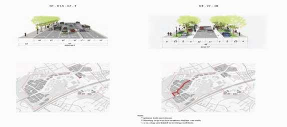
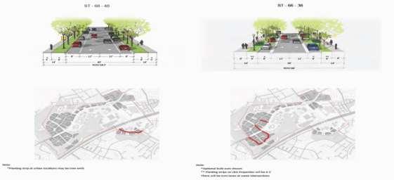
78 Beauregard Small Area Plan Page A74

79 Beauregard Small Area Plan Page A75

80 Beauregard Small Area Plan Page A76
81 Baileys Planning District BAILEYS PLANNING DISTRICT Introduction The Baileys Planning District is located in the east central portion of Fairfax County. There are two Community Business Centers (CBC) located in the Planning District: Seven Corners and Baileys Crossroads. Non-residential, institutional uses in the Planning District include schools, religious facilities, libraries, and other public facilities. Low density, residential neighborhoods predominate and are located throughout the Planning District. Higher density, residential areas of townhouses, garden apartments, mid- and high-rise apartments and condominiums, are located primarily adjacent to the Community Business Centers, along the major thoroughfares. The Concept for Future Development envisions that the Baileys Planning District will develop primarily as Suburban Neighborhoods with commercial development focused in the Seven Corners and Baileys Crossroads Community Business Centers. District wide recommendations Travel within and through the Baileys Planning District is affected by land uses and transportation facilities in adjacent districts, as well as throughout the Northern Virginia region. The primary arterial Route 7 between Seven Corners and Baileys Crossroads should be widened in general conformance with the right-of-way and design features of the VDOT project. This widening may eliminate portions of existing service drives. In areas where a continuous right turn lane is provided in addition to the six through lanes, in general conformance with the right-of-way and design features of the adopted VDOT Route 7 project plans, the continuous right turn lane may be an appropriate alternative to a service drive. Where there is no service drive, consolidation of entrances and provision for interparcel access through travelways should be provided. Area-wide recommendations The area-wide recommendations are intended to help achieve the future vision for the Baileys Crossroads CBC. Transportation The vision of the Baileys Crossroads CBC promotes a mix of land uses served by a multimodal transportation system. Various planned transportation improvements will facilitate this vision, while accommodating current and future commuters and residents within and around the Baileys Crossroads CBC. Public Transportation Leesburg Pike (Route 7) from the intersection with Columbia Pike, heading north to the City of Falls Church, and then to Tysons Corner is designated as an Enhanced Public Transportation Corridor (EPTC). This designation means that this corridor has been designated a major public transportation facility by the county and transit options such as light rail, bus rapid transit, or Page A77
82 Baileys Planning District other public transportation options should be explored for implementation at a later date as the need arises. Columbia Pike Transit Project (with Streetcar option) The Fairfax County Board of Supervisors endorsed the recommendation of the Pike Transit Alternatives Analysis, completed in July 2005 that a modified streetcar option can be carried forward as the locally preferred alternative for transit in the area. It is considered a modified streetcar option because buses also operate on the same route as the street car during the peak periods. The transit stations will be focal points for redevelopment with the densest development occurring within ¼ mile of the stations. Local Bus Service and Express Bus Service While portions of the CBC will be served by the Columbia Pike transit project, there is the need to continue local bus service to serve the outlying areas of the CBC and surroundings neighborhoods in Bailey Crossroads. Leesburg Pike (Route 7) in the Baileys Crossroads CBC and heading north to Tysons Corner is already designated as an EPTC on which bus service or some other form of transit should be provided. Multimodal Transportation Hub (Transit Center) The major multi-modal transportation hub planned in the Baileys Crossroads CBC is located along Jefferson Street with the general location shown on the Transportation Plan Map. This multimodal transit center will be located adjacent to the proposed streetcar station location on Jefferson Street and is proposed to be the transfer point between express and local buses and the Columbia Pike transit project. The transit center is also envisioned to accommodate alternative modes of transportation such as bicycles, cars and car sharing, taxis, and other personal transportation services. Road Network and Circulation The streets should provide a level of connectivity and accommodate all modes of transportation to the fullest extent possible. Reducing the number of driveway access points on the arterials, especially Leesburg Pike and Columbia Pike, and collectors (as the need arises) in the Baileys Crossroads CBC should be implemented to improve safety, connectivity and mobility. A high level of service should be maintained for pedestrians and cyclists, including safety and security, direct pathways, reasonable grades, and minimized delays at intersections especially within a quarter mile of the stations. Funding of Transportation Improvements and Service The traditional method of funding these transportation improvements has been through Federal, State and County sources; however, some combination of public and private sector funding may be necessary to cover the costs associated with these improvements and to expedite implementation. Page A78

83 Baileys Planning District Figure A 29: Baileys Crossroads Community Business Center Page A79
84 Alexandria Transportation Master Plan ALEXANDRIA TRANSPORTATION MASTERPLAN REVIEW Introduction The Alexandria Transportation Masterp6-lan focuses on six areas. These areas include Transit, Pedestrian, Bicycle, Streets, Parking and Funding. Included in the plan is the discussion of the three priority transit corridors which are discussed in greater detail in the Alexandria High Capacity Transit Corridor Study. This primarily makes up the Transit component of the Alexandria Transportation Masterplan. Transit High Capacity Transit Corridors (A, B and C) The transit section of the masterplan aims at establishing three corridors known as corridors A, B and C. These corridors are discussed in greater detail in the High Capacity Transit Corridor Study. The plan considers a wide range of transit modes for the three corridors it identifies from local, shuttle buses to Light Rail. The Map below shows a view of the three corridors in the City of Alexandria. The plan also includes strategies for transit supportive land-use. This includes coordination with City planning efforts by reviewing and commenting on all new land use/development adjacent to the proposed corridors. These reviews include the following: Identification of rights-of-way to be dedicated as part of future planning or approval Encouragement of coordination of an appropriate mixture and density of activity around transit stations Addition of design requirements to create a comfortable walking environment for pedestrians and good connections for bicyclists. Page A80

85 Alexandria Transportation Master Plan Figure A 30: Proposed High-Capacity Transit Corridors Neighborhood Circulators The Alexandria Transportation Master Plan proposes neighborhood circulation to improve mobility between major developments and nearby destinations in addition to Metro stations. The plan proposes consolidation of existing private shuttle services. By consolidating these services the plan intends to integrate stops and schedules providing connectivity between neighborhoods and dedicated transit corridor services. These neighborhood circulators would be typically found in lower-density neighborhoods and shopping areas providing an increase in city-wide mobility options. The existing routes are funded through the Transportation Management Plan (TMP) and the plan anticipates that these newly consolidated services will continue to be funded as such. Bicycle The Alexandria Transportation Master Plan has identified a number of areas in which it intends to make bicycle improvements and enhancements. The map below shows the many corridors and locations where these improvements are planned. Bicycle-Transit Connections The Transportation Plan for Alexandria recommends the integration of bicycle facilities and transit. Among the five objectives outlined in the plan which include marketing and promotion of the use of bicycles as an alternative form of transportation are: Page A81

86 Alexandria Transportation Master Plan Updates to the City of Alexandria s ordinances, policies and regulations to encourage bicycle transportation and a seamless integration with transit Review of all projects in the development and planning process ensuring adequate accommodation of bicycle and access to facilities including showers, lockers and bicycle parking. Figure A 31: Proposed Bicycle Facilities in Alexandria Streets City of Alexandria is looking to take a more comprehensive approach to streets by focusing less on how to accommodate the automobile as has been done in the past. Overall, this transportation plan update addresses City streets as a shared resource. The plan considers the importance of decision making regarding development and redevelopment insisting that they must conform to the future transportation vision of the City. The plan recommends that these development plans consider the following: Implementation of dedicated transit lanes Building access Page A82
ARLINGTON COUNTY TRANSIT DEVELOPMENT PLAN
 p EXECUTIVE SUMMARY Report Prepared by: ARLINGTON COUNTY TRANSIT DEVELOPMENT PLAN The Arlington County Transit Development Plan (TDP) is an effort to evaluate and assess the performance, connectivity,
Northern Virginia Region Draft Needs Summary
 Needs Map: Need A A DEMAND The ability of communities around transit stations (particularly the areas within 1-2 miles of the stations and other travel hubs) to attract skilled workers and grow businesses
NEED ECONOMIC TRANSPORTATION LOCATIONS EXAMPLE
 A. Enhance multimodal networks and facilities around transit access points such as existing and emerging rail stations, high capacity bus stops, and intermodal transfer centers There is a need for improved
Fairfax Transportation Committee I-66 Multimodal Improvements Inside the Beltway. January 20, 2015
 Fairfax Transportation Committee I-66 Multimodal Improvements Inside the Beltway January 20, 2015 I-66 Multimodal Improvements I-66 Multimodal Study (2012 / 2013) Tolling element Multimodal solutions Future
ARLINGTON COUNTY, VIRGINIA
 ARLINGTON COUNTY, VIRGINIA County Board Agenda Item Meeting of February 25, 2017 DATE: January 5, 2017 SUBJECT: Amendment of the (MTP) Goals and Policies Document, MTP Map and Transit Element to incorporate
ATTACHMENT A. Detailed Study Scope. I-66 (Inside) Multi-modal Study Scope
 Multi-modal Study Scope") ATTACHMENT A Detailed Study Scope I-66 (Inside) Multi-modal Study Scope EXECUTIVE SUMMARY The Virginia Department of Transportation (VDOT) seeks consultant assistance in identifying and evaluating a range
ATTACHMENT A Detailed Study Scope I-66 (Inside) Multi-modal Study Scope EXECUTIVE SUMMARY The Virginia Department of Transportation (VDOT) seeks consultant assistance in identifying and evaluating a range
Fairfax County Countywide Transit Network Study
 Fairfax County Countywide Transit Network Study Proposed High Quality Transit Network Concept Metropolitan Washington Council of Governments Travel Forecasting Subcommittee September 20, 2013 1 Presentation
CHAPTER 2: Goals, Objectives & Standards
 CHAPTER 2: Goals, Objectives & Standards Report Prepared by: Contents 2 GOALS, OBJECTIVES AND STANDARDS... 2-1 2.1 Goals, Objectives, Performance Measures, and Targets... 2-1 2.2 Service Standards... 2-6
Alexandria City Council Arlington County Board Joint Work Session
 1 Alexandria City Council Arlington County Board Joint Work Session October 14, 2010 Agenda 2 1. Welcome and Introductions 2. Purpose and Overview of Coordination Efforts 3. Route 1 Corridor Development
This document has been developed to provide context to the Board as part of the strategic planning process. Regional development and travel trends
 1 This document has been developed to provide context to the Board as part of the strategic planning process. Regional development and travel trends and forecasts are provided, including population, employment,
WELCOME. Schedule. Contact Information. Please Provide Written Comments
 WELCOME Schedule April 18, 2012 Open House: 6:30 p.m. to 8:30 p.m. Project Presentation: 7:00 p.m. Mary Ellen Henderson Middle School 7130 Leesburg Pike Falls Church, VA 2203 Contact Information Kala Leggett
I-66 Corridor Improvements Outside the Capital Beltway in Northern Virginia, USA
 15th International Conference on Managed Lanes I-66 Corridor Improvements Outside the Capital Beltway in Northern Virginia, USA Case Study for Funding of Transit Service and Transportation Demand Management
EXECUTIVE SUMMARY REGIONAL TRANSPORTATION PLAN 2050
 EXECUTIVE SUMMARY REGIONAL TRANSPORTATION PLAN 2050 Introduction Goals Policies, and Performance Measures Growth Forecast and Planned Land Use Development Key Recommendations i Executive Summary April
EVALUATION OF ALTERNATIVES CARRIED FORWARD
 1 EVALUATION OF ALTERNATIVES CARRIED FORWARD This chapter presents a comparative evaluation of the alternatives carried forward in this Final Environmental Impact Statement (EIS). The intent of this evaluation
Regional Bus Rapid Transit
 Regional Bus Rapid Transit Efforts Board Transportation Committee October 20, 2009 There are a Variety of Regional Bus Rapid Transit Study Efforts They include: NVTA s TransAction 2030 Plan Transportation
Town of Lexington Planning Board
 Town of Lexington Planning Board TRANSPORTATION DEMAND MANAGEMENT POLICY Adopted by Vote of the Board, September 16, 1998 Originally Adopted March 10, 1997 OBJECTIVES: This Policy focuses on meeting the
Evaluation of Alternatives
 Chapter 9.0 Evaluation of Alternatives Chapter 9.0 provides a summary evaluation of the No Build Alternative and the Preferred Alternative. The evaluation contained within this chapter is an assessment
VTrans2040 Multimodal Transportation Plan Corridors of Statewide Significance Needs Assessment North-South Corridor
 VTrans2040 Multimodal Transportation Plan Corridors of Statewide Significance Needs Assessment North-South Corridor Table of Contents I. Corridor Overview Demographics and Economic Trends Corridor Travel
TransAction Plan October 2017
 Transportation Action Plan for Northern Virginia TransAction Plan October 2017 TransAction is the multimodal transportation master plan for Northern Virginia. It is a long range plan addressing regional
Executive Summary and Staff Recommendation
 Executive Summary and Staff Recommendation January 2017 Project Background In 2010, NFTA completed an update to our 2001 Strategic Assessment. This assessment identified four corridors for potential rail
APPENDIX B - GLOSSARY FEBRUARY 2017
 APPENDIX B - GLOSSARY FEBRUARY 2017 DENVERMOVES Transit Denver Moves: Transit - ii - APPENDIX B TRANSIT AND MOBILITY GLOSSARY Amenities, stop or station: Objects or facilities (such as a shelter, bench,
SOUTHWEST LRT (METRO GREEN LINE EXTENSION)
") 8 Evaluation of Alternatives This chapter evaluates the effectiveness of the No Build Alternative and the Southwest Light Rail Transit (LRT) Project (the Project) based on the information contained in
8 Evaluation of Alternatives This chapter evaluates the effectiveness of the No Build Alternative and the Southwest Light Rail Transit (LRT) Project (the Project) based on the information contained in
VIA Long Range Plan Glossary
 VIA Long Range Plan Glossary Accessibility. Accessibility is the ability to reach opportunities (economic, social, etc.) within a certain geographical area. Americans with Disabilities Act (ADA). Passed
Transit Development Plan. January 2016 Update
 Transit Development Plan January 2016 Update Department of Environmental Service January 26, 2016 Transit Development Plan What is a TDP? System-wide analysis of bus service in the County ART and Metrobus
Transit Service Guidelines
 G R E AT E R VA N CO U V E R T R A N S P O RTAT I O N A U T H O R I T Y Transit Service Guidelines PUBLIC SUMMARY REPORT JUNE 2004 Greater Vancouver Transportation Authority TRANSIT SERVICE GUIDELINES
TRANSPORTATION RELATIONSHIP TO OTHER ELEMENTS OF THE PLAN AND COUNTY REGULATIONS VISION FOR TRANSPORTATION PLANNING ROAD NETWORK SECTION 7
 TRANSPORTATION Like many growing western counties, Douglas County focuses on one of the most integral elements in land-use planning: transportation. The primary purpose of a transportation network is to
APPENDIX A - PLANS AND POLICY REVIEW FEBRUARY 2017
 APPENDIX A - PLANS AND POLICY REVIEW FEBRUARY 2017 DENVERMOVES Transit Denver Moves: Transit APPENDIX A PLANS AND POLICY REVIEW 2035 Metro Vision Regional Transportation Plan (MVRTP) (2011) 2040 Fiscally
Transportation and Utilities
 4 Section 4 Transportation and Utilities 4.0 Introduction Transportation and utility systems are essential to accommodate and support development proposed in the Future Land Use Map. The following pages
ALBION FLATS DEVELOPMENT EXISTING TRAFFIC CONDITIONS AND POTENTIAL IMPACTS
 EXISTING TRAFFIC CONDITIONS AND POTENTIAL IMPACTS FINAL REPORT SEPTEMBER 2010 TABLE OF CONTENTS 1.0 INTRODUCTION 1 2.0 EXISTING TRAFFIC CONDITIONS 2 3.0 FUTURE TRAFFIC CONDITIONS 3 4.0 POTENTIAL IMPACTS
12 Evaluation of Alternatives
 12 Evaluation of Alternatives This chapter evaluates the effectiveness of the No-Build Alternative and the proposed METRO Blue Line Light Rail Transit (BLRT) Extension project based on the information
Revenues and expenditures increase based on the tax district increase due to increases in real estate assessments in CY 2016 compared to CY 2015.
 CRYSTAL CITY, POTOMAC YARD, AND PENTAGON CITY TAX INCREMENT FINANCING AREA Our Mission: To provide a supplemental financial mechanism for the revitalization of Crystal City, Potomac Yard, and Pentagon
I-95 / I-395 Integrated Corridor Management. Hari Sripathi, P.E. Regional Operations Director
 I-95 / I-395 Integrated Corridor Management Hari Sripathi, P.E. Regional Operations Director Purpose of ICM Initiative Address real time demand management in I-95/I- 395 corridor Identify tools to provide
Columbia Pike Transit Initiative
 The purpose of this project is to implement higher-quality and higher-capacity transit service in the corridor in order to: Provide more capacity; Enhance access within the corridor and provide connections
APPENDIX H- ALTERNATIVES PREVIOUSLY CONSIDERED
 APPENDIX H- ALTERNATIVES PREVIOUSLY CONSIDERED APPENDIX H: ALTERNATIVES PREVIOUSLY CONSIDERED This appendix provides an overview of the process that led to the selection of the Locally Preferred Alternative
3. STATION SPACING AND SITING GUIDELINES
 3. STATION SPACING AND SITING GUIDELINES The station spacing and siting guidelines are summarized in Table 3-1. Table 3-1 also includes benchmark information for local transit service and express bus as
Transportation Demand Management (TDM) Plan 2075 Broadway, Redwood City, CA
 Plan 2075 Broadway, Redwood City, CA") Transportation Demand Management (TDM) Plan 2075 Broadway, Redwood City, CA Prepared For: Lane Partners, LLC Prepared By: SANDIS 644 Menlo Avenue, Second Floor 636 9 th Street Menlo Park, CA 94025 Oakland,
Transportation Demand Management (TDM) Plan 2075 Broadway, Redwood City, CA Prepared For: Lane Partners, LLC Prepared By: SANDIS 644 Menlo Avenue, Second Floor 636 9 th Street Menlo Park, CA 94025 Oakland,
Operations Guidelines for Metrobus in. Bus Rapid Transit/Light Rail Transit/Streetcar Corridors. Final Report
 Operations Guidelines for Metrobus in Bus Rapid Transit/Light Rail Transit/Streetcar Corridors Final Report Operations Plan for Metrobus in BRT/LRT/SC Corridors Table of Contents 1 Forward... 1 2 Executive
VRE Gainesville-Haymarket Alternatives Analysis Report
 EXECUTIVE SUMMARY VRE Gainesville-Haymarket Alternatives Analysis Report Prepared for Virginia Railway Express (VRE) Alexandria, Virginia Prepared by Vienna, Virginia in association with AECOM The Perspectives
Section 11: Transportation Strategies Toolbox
 Section 11: Transportation Strategies Toolbox A transportation strategies toolbox was developed to provide a systematic approach to identify potential strategies that address corridor transportation needs.
Summary of transportation-related goals and objectives from existing regional plans
 SMTC 2050 Long Range Transportation Plan Appendix A: Summary of transportation-related goals and objectives from existing regional plans SMTC 2050 Long Range Transportation Plan Summary of transportation-related
Safety and Operations Committee. Information Item IV-A. December 13, 2018
 Safety and Operations Committee Information Item IV-A December 13, 2018 FY2020 Station Platforms Project Page 21 of 46 Washington Metropolitan Area Transit Authority Board Action/Information Summary Action
NORTHERN VIRGINIA TRANSPORTATION PLAN
 NORTHERN VIRGINIA TRANSPORTATION PLAN November 2012 Table of Contents TransAction 2040 Plan Area...1 Communities and Facilities Covered in TransAction 2040... 1 TransAction 2040 Plan Methodology...2 Individual
Prepared By: Gorove/Slade Associates, Inc.
 Traffic Impact Analysis Monument View Arlington County, Virginia Prepared For: Gensler 2020 K Street, NW Suite 200 Washington DC 20006 Prepared By: Gorove/Slade Associates, Inc. PREPARED BY: Gorove/Slade
TRANSIT SERVICE GUIDELINES
 CHATHAM AREA TRANSIT AUTHORITY FEBRUARY 2014 Table of Contents 1. PURPOSE... 3 2. CAT SERVICE GUIDELINES... 3 3. TRAVEL MARKETS... 4 4. TRANSIT COVERAGE... 4 5. TRANSIT ACCESS... 4 6. BUS STOP SPACING
TransAction Plan Draft for Public Comment Spring/Summer 2017
 Transportation Action Plan for Northern Virginia TransAction Plan Draft for Public Comment Spring/Summer 2017 Comments are invited on this TransAction Plan, and associated TransAction Plan Project List.
Priorities are for AG comment at today's meeting. Four time frames proposed for implementation
 Prioritization Overview Priorities are for AG comment at today's meeting Four time frames proposed for implementation Prioritization Overview Some editing of Principles to read as implementation versus
3.0 REVIEW OF PREVIOUS STUDIES
 3.0 REVIEW OF PREVIOUS STUDIES This section of the highlights the significant features from previous plans and studies that could impact the development of the I-20 East Transit Initiative. Much of the
Final Land Use and Development Opportunities Report 5.0 Environmental Impact/Environmental Consequences
 Figure 5-6. Century City 1/4-Mile Station Area August 16, 2010 Page 5-14 Figure 5-7. Wilshire/Westwood 1/4-Mile Station Area August 16, 2010 Page 5-15 Alternative 1 would be constructed underneath existing
Long-Range Plan Task Force: Draft Analysis Results
 Long-Range Plan Task Force: Draft Analysis Results November 15, 2017 Prepared for: National Capital Region Transportation Planning Board Transportation Planning Board Item #9 Presentation Components Analysis
SCS Scenario Planning
 E SCS Scenario Planning Introduction As part of the 2035 MTP/SCS process, AMBAG developed a series of land use and transportation alternative scenarios for evaluation and testing to demonstrate how the
6.0 CONGESTION HOT SPOT PROBLEM AND IMPROVEMENT TRAVEL DEMAND MODEL ANALYSIS
 6.0 CONGESTION HOT SPOT PROBLEM AND IMPROVEMENT TRAVEL DEMAND MODEL ANALYSIS 6.1 MODEL RUN SUMMARY NOTEBOOK The Model Run Summary Notebook (under separate cover) provides documentation of the multiple
Executive Summary. Study Background
 Executive Summary ES 1.1 Introduction The Capitol Region Council of Governments (CRCOG) and the Connecticut Department of Transportation (CTDOT) initiated the (BTS) in 2006 to identify near and long-term
ACTIVE TRANSPORTATION ADVISORY COMMITTEE. Memphis MPO March 30, 2015
 ACTIVE TRANSPORTATION ADVISORY COMMITTEE Memphis MPO March 30, 2015 Agenda Welcome & Introductions Announcements and Briefings Livability 2040: Regional Transportation Plan Congestion Management Process
North Woodbridge Urban Mixed Use Master Zoning Plan
 North Woodbridge Urban Mixed Use Master Zoning Plan 18 October 2005 Project Team: Potomac Communities A premier residential, business and visitor location on the Potomac River 2004-2008 Strategic Plan
Developing New Revenue Streams For Transit
 Developing New Revenue Streams For Transit Jennifer Mitchell Agency Director Rail~Volution October 23, 2018 DRPT Role in Transportation DRPT focuses on moving people and goods: Rail Public transportation
TSM/TDM (Transit and Roadway Efficiency) Concept - Analysis and Results
 Concept - Analysis and Results") M E M O R A N D U M TSM/TDM (Transit and Roadway Efficiency) Concept - Analysis and Results TO: FROM: Task Force and Oversight Team Steve Perone/PTV America Tim Burkhardt/CH2M HILL DATE: Revised: August
M E M O R A N D U M TSM/TDM (Transit and Roadway Efficiency) Concept - Analysis and Results TO: FROM: Task Force and Oversight Team Steve Perone/PTV America Tim Burkhardt/CH2M HILL DATE: Revised: August
VTrans2040 Multimodal Transportation Plan Corridors of Statewide Significance Needs Assessment North-South Corridor (G)
") VTrans2040 Multimodal Transportation Plan Corridors of Statewide Significance Needs Assessment North-South Corridor (G) UV 234 Table of Contents I. Corridor Overview Demographics and Economic Trends Corridor
VTrans2040 Multimodal Transportation Plan Corridors of Statewide Significance Needs Assessment North-South Corridor (G) UV 234 Table of Contents I. Corridor Overview Demographics and Economic Trends Corridor
NEPA and Design Public Hearings
 NEPA and Design Public Hearings Monday, December 5, 2016 Washington-Lee High School 1301 N. Stafford Street Arlington, VA 22201 Thursday, December 8, 2016 Mary Ellen Henderson Middle School 7130 Leesburg
Transform 66 Multimodal Project: Prioritization Process and Evaluation Criteria Approved March 3, 2016
 Transform 66 Multimodal Project: Prioritization Process and Evaluation Criteria Approved March 3, 2016 The Memorandum of Agreement (MOA) for the Transform 66: Inside the Beltway Project directs NVTC to
Appendix D: Functional Classification Criteria and Characteristics, and MnDOT Access Guidance
 APPENDICES Appendix D: Functional Classification Criteria and Characteristics, and MnDOT Access Guidance D.1 Functional classification identifies the role a highway or street plays in the transportation
Operational Analysis of Dulles Toll Road Ramps to Tysons. Board Transportation Committee Meeting September 17, 2013
 Operational Analysis of Dulles Toll Road Ramps to Tysons Board Transportation Committee Meeting September 17, 2013 Seyed Nabavi Fairfax County Department of Transportation 1 Agenda Overview & Assumptions
SUMMARY REPORT September 11, 2012 DRAFT
 SUMMARY REPORT Table of Contents TransAction 2040 Study Area... 1 Study Area Corridors and Map... 1 Communities and Facilities Covered in TransAction 2040... 1 TransAction 2040 Study Methodology... 2 Individual
Demand Reduction Assumptions Used For Travel Demand Analysis of EIS Alternatives
 M E M O R A N D U M Demand Reduction Assumptions Used For Travel Demand Analysis of EIS Alternatives TO: FROM: Project Management Team Steve Perone/PTV America DATE: Revised: February 6, 2009 Background
FAIRFAX COUNTY PARK-AND-RIDE DEMAND ESTIMATION STUDY
 FAIRFAX COUNTY PARK-AND-RIDE DEMAND ESTIMATION STUDY Michael Demmon GIS Spatial Analyst Fairfax County, DOT Fairfax, VA Scudder Wagg Planner Michael Baker Jr, Inc. Richmond, VA Additional support from:
Appendix D Functional Classification Criteria and Characteristics, and MnDOT Access Guidance
 Appendix D Functional Classification Criteria and Characteristics, and MnDOT Access Guidance Functional classification identifies the role a highway or street plays in the transportation system. Some highways
CHAPTER 4 FUTURE TRENDS
 CHAPTER 4 FUTURE TRENDS 4.1 LAND USE SCENARIO PLANNING Scenario planning represents the next generation of analytical processes created to evaluate the influence of development intensities and land use
Draft Strategic Mobility Plan Short-Term Action Plan 2018 to 2022
 Draft Strategic Mobility Plan Short-Term Action Plan 2018 to 2022 ET1: ET2: 2018 By 2018, provide monthly project updates at board meetings and online By 2018, provide updates for the SMP action items
The Policies section will also provide guidance and short range policies in order to accomplish the goals and objectives.
 4 Goals & Objectives INTRODUCTION The 2015-2040 MTP preserves and promotes the quality of life and economic prosperity of the MAB by providing a transportation system consistent with the regional goals.
April 12, Dear Chairman Wojahn and Members of the Transportation Planning Board:
 April 12, 2014 The Honorable Patrick Wojahn National Capital Region Transportation Planning Board c/o Metropolitan Washington Council of Governments 777 North Capital Street, NW, Suite 300 Washington,
TRANSPORTATION MOBILITY PLAN GUIDELINES
 TRANSPORTATION MOBILITY PLAN GUIDELINES for Development Applications November 2016 Executive Summary The Regional Municipality of York (the Region) is located in the heart of the Greater Toronto Area (GTA)
APPENDIX A. Plan Survey Detail. Doug Kerr (Flickr)
") APPENDIX A Plan Survey Detail Doug Kerr (Flickr) Table of Contents Page APPENDIX A Plan Survey Detail... A-1 Statewide Plans and Policies... A-3 County Plans and Policies... A-6 Local Jurisdiction Plans
APPENDIX A Plan Survey Detail Doug Kerr (Flickr) Table of Contents Page APPENDIX A Plan Survey Detail... A-1 Statewide Plans and Policies... A-3 County Plans and Policies... A-6 Local Jurisdiction Plans
MARC Brunswick/Frederick Line Improvement Proposal
 MD State Highway Administration Project No. M00695172 IS 270 Innovative Congestion Management Project MARC Brunswick/Frederick Line Improvement Proposal Action Committee for Transit November 2016 MARC
Notice of Public Hearing
 Notice of Public Hearing Washington Metropolitan Area Transit Authority Docket B16-03: Restriction of Metrorail Operating Hours Purpose Notice is hereby given that a public hearing will be held by the
Chapter 3 Stakeholder Interviews and Summary of Needs
 Chapter 3 Stakeholder Interviews and Summary of Needs 42 CHAPTER 3 STAKEHOLDER INTERVIEWS AND SUMMARY OF NEEDS CHAPTER 3. STAKEHOLDER INTERVIEWS AND SUMMARY OF NEEDS An extensive stakeholder interview
Appendix B2: Factors Affecting Transit Choice
 Appendix B2: Factors Affecting Transit Choice 1 TRANSIT MARKET The transit market comprises those trips which have the option of taking transit, that is, those trips for which the trip origin and trip
APPENDIX A: Transportation Planning Rule
 A APPENDIX A: Transportation Planning Rule This appendix contains the full text of Oregon s Transportation Planning Rule (TPR). Transportation Planning Rule (TPR) NOTE: The official copy of an Oregon Administrative
Chapter Five: Transportation
 Chapter Five: Transportation Purpose and Intent Transportation Goals and Policies Land Use Assumptions Airway Heights Transportation System Facilities and Services Pedestrian Transportation Public Transportation
Commonwealth Transportation Board I-66 Corridor Briefing Outside the Beltway Route 15 to I-495
 Commonwealth Transportation Board I-66 Corridor Briefing Outside the Beltway Route 15 to I-495 January 13, 2015 1 Project Status Update Transit P3 Procurement I-66 Corridor Briefing Overview Major Project
CTA Blue Line Forest Park Branch Feasibility/Vision Study: Transit Ridership Forecasting Analysis Technical Memorandum Submitted By
 Feasibility/Vision Study: Technical Memorandum Submitted By WSP Parsons Brinckerhoff 30 N. LaSalle Street, Suite 4200 Chicago, IL 60602 December 2016 TABLE OF CONTENTS 1.0 INTRODUCTION... 1 1.1 Organization
CONNECTING LAND USE AND TRANSPORTATION PLANNING THE LINKAGE MODEL FOR METROPOLITAN PLANNING ORGANIZATIONS
 NEW YORK STATE ASSOCIATION OF METROPOLITAN PLANNING ORGANIZATIONS CONNECTING LAND USE AND TRANSPORTATION PLANNING THE LINKAGE MODEL FOR METROPOLITAN PLANNING ORGANIZATIONS Prepared by Chris O'Neill, CDTC
Traffic generated by future approved, planned or potential development activity.
 IV. FUTURE CONDITIONS IV.A. Development of Future Year Traffic Forecasts In order to assess future roadway conditions, traffic projections were developed based on several sources: Growth in existing through
Chapter 4: Transportation and Land Use
 Chapter 4: Transportation and Land Use Transportation and land use together make possible the wide range of destination opportunities in the region. Transportation provides the connections, and, in turn,
CHAPTER 8 TRANSPORTATION ELEMENT
 CHAPTER 8 TRANSPORTATION ELEMENT Section 8.01 Purpose: The purpose of this Chapter (element) is to establish the desired and projected transportation system within Niceville and to plan for future motorized
1003 K Street NW, Suite 209 Washington, DC MEMORANDUM. Matthew Ridgway, Nat Bottigheimer, and Alex Rixey, Fehr & Peers
 1003 K Street NW, Suite 209 Washington, DC 20001 202.854.2750 MEMORANDUM Date: To: From: Subject: Eric Graye, M-NCPPC Matthew Ridgway, Nat Bottigheimer, and Alex Rixey, Fehr & Peers Performance Metrics
From Policy to Reality
 From Policy to Reality Updated ^ Model Ordinances for Sustainable Development 2000 Environmental Quality Board 2008 Minnesota Pollution Control Agency Funded by a Minnesota Pollution Control Agency Sustainable
The Role of Transportation Systems Management & Operations in Supporting Livability and Sustainability
 The Role of Transportation Systems Management & Operations in Supporting Livability and Sustainability Michael Grant, ICF International February 7, 2012 NTOC Webinar Highlights of FHWA/FTA Primer Background:
VDOT and DRPT MPO and PDC Winter Meeting Amy Inman Planning & Mobility Programs Administrator Virginia Department of Rail and Public Transportation
 VDOT and DRPT MPO and PDC Winter Meeting Amy Inman Planning & Mobility Programs Administrator Virginia Department of Rail and Public Transportation www.drpt.virginia.gov 1 DRPT Customers 54 Transit Systems
Los Angeles County Congestion Reduction Demonstration Project
 Los Angeles County Congestion Reduction Demonstration Project frequently asked questions update #1 /august 2008 Los Angeles County Metropolitan Transportation Authority (Metro), California Department of
Purpose of the Public Hearing
 www.virginiadot.org Public Hearings Interstate 66 - Outside the Beltway Tier 1 Draft Environmental Impact Statement From U.S. Route 15 To I-495 Prince William and Fairfax Counties Wednesday, March 13,
EXAMPLES OF COMPREHENSIVE PLAN POLICIES HOW TO ESTIMATE THE BENEFITS OF THE CTR PROGRAM
 TABLE OF CONTENTS INTRODUCTION... I BACKGROUND OF THE COMMUTE TRIP REDUCTION EFFICIENCY ACT... II MAKING THE CONNECTION BETWEEN COMMUTE TRIP REDUCTION AND THE GROWTH MANAGEMENT ACT... IV CTR PLANNING AND
4: Transportation and Land Use
 Chapter Figure 4-1: Recent development has brought more housing and mixed use Downtown Minneapolis - looking north from E 15th Street at the Grant Street / 11th Street exit 4: Transportation and Land Use
Chapter 4. Recommendations
 Chapter 4 Recommendations Project Rating Methodology 1.0 Introduction This chapter outlines the prioritization of potential investments that were identified during this MIS process. During this study there
LARKSPUR SMART STATION AREA PLAN. Public Workshop December 3, 2013
 LARKSPUR SMART STATION AREA PLAN Public Workshop December 3, 2013 0 PURPOSE OF Provide information about the regional planning context for the Larkspur Station Area, including Plan Bay Area, SMART, and
LAND USE POLICIES BY COMMUNITY DESIGNATION
 137 2040 138 Land Use Policies by Community Designation As discussed earlier in Thrive MSP 2040, the Council assigns a community designation to each city and township. This designation indicates the overall
TRANSPORTATION AND LAND USE
 TRANSPORTATION AND LAND USE INTRODUCTION The 2020 and 2030 GHG projections estimate that transportation emissions in the unincorporated area will increase considerably in the next two decades. Minimizing
KNOXVILLE REGIONAL TRANSIT CORRIDOR STUDY
 KNOXVILLE REGIONAL TRANSIT CORRIDOR STUDY April 2013 Alignments Alignments Magnolia Ave Northeast corridor Knoxville Transit Center Hall of Fame Dr Magnolia Ave Prosser Rd. Corridor contains commercial,
Lynnwood Link Extension 2013 Draft EIS Comments and Responses. Page 945
 I-441-001 Thank you for your comments about the importance of the Latvian Center to the Latvian community. Following the Draft EIS, the Sound Transit Board directed Sound Transit to develop a Preferred
HB 599 Study Overview A detailed evaluation framework and methodology to evaluate regionally significant projects and their impact on congestion
 HB 599 Study Overview A detailed evaluation framework and methodology to evaluate regionally significant projects and their impact on congestion Kanathur Srikanth VDOT NoVA District VASITE June 26, 2014
CRYSTAL CITY, POTOMAC YARD, AND PENTAGON CITY TAX INCREMENT FINANCING AREA
 CRYSTAL CITY, POTOMAC YARD, AND PENTAGON CITY TAX INCREMENT FINANCING AREA Our Mission: To provide a supplemental financial mechanism for the revitalization of Crystal City, Potomac Yard, and Pentagon
ITEM 11 - Information January 21, Briefing on Project Submissions for the 2015 CLRP
 ITEM 11 - Information January 21, 2015 Briefing on Project Submissions for the 2015 CLRP Staff Recommendation: Issues: Background: Receive briefing on the major projects submitted for the 2015 CLRP by