Interfacing R in a GIS environment for National Forest Systems
|
|
|
- Collin Merritt
- 5 years ago
- Views:
Transcription
1 Interfacing R in a GIS environment for National Forest Systems Tracey S. Frescino USDA, Forest Service, Interior-West, Rocky Mountain Research Station, Forest Inventory and Analysis, Ogden, Utah Kevin A. Halverson USDA, Forest Service, Intermountain Region, Region 4 Vegetation Information Management, Ogden, Utah
2 Main Goal Collaboration and Technology Transfer within USDA Forest Service National Forest System (NFS) Research and Development (R&D) NFS lands R&D regions
3 Objectives Define needs of NFS (Region 4) Present resources and tools available in Research (Interior-West, Rocky Mountain Station, Forest Inventory and Analysis (FIA) Program) Adapt resources and tools to accommodate NFS needs Design user-friendly interface for transferring technology


4 Overview of National Forest System

5 Region 4: Intermountain Region
6 National Forest Vegetation Information Needs Forest Planning Wildlife Habitat Wildfire Planning Hydrologic Timber Recreation Climate Adaptation Typical Variables Vegetation Dominance Type Canopy Cover Tree and Shrub Size Class Vegetation Structure Disturbance Biomass Habitat Type..


7 How the USFS Estimates Areas Vegetation Mapping Remote Sensing derived Interdisciplinary Effort Areas calculated using GIS Vegetation Sampled Inventory Field or Photo-interpreted Systematic and unbiased design Requirement of algorithms to apply area expansion factors for estimates
8 Maps use Sampled Data for Validation
9 FIA: Forest Inventory & Analysis National program to sample forest cover every five kilometers Pre-field phase is photo-based Field-sampled when certain criteria are met Maintains an Oracle Database filled with millions of records regarding plots Complex algorithms are used to summarize Plot locations are confidential. Public may only access fuzzed plot locations


10 FIA PLOTS* *Fuzzed FIA Plots are shown due to confidentiality of true locations

11 Mechanics of Calculation
 Percent area Alpine Alpine Vegetation 38302 0.")

12 Calculating Areas MAP: GIS Exercise FIA: Statistical Exercise Security Authentication Oracle Software Reports Vegetation Type Area (ac) Percent area Alpine Alpine Vegetation % Conifer Forest Conifer Mix 253, % Douglas-fir 1,303, % Douglas-fir/Lodgepole Pine 61, % Douglas-fir/Ponderosa Pine 37, % Lodgepole Pine 364, % Ponderosa Pine 69, % Spruce/Fir 207, % Whitebark Pine Mix 413, %


13 The Need: GIS Based Tools for FIA Tool Oracle Reports Vegetation Type Area (ac) Percent area Alpine Alpine Vegetation % Conifer Forest Conifer Mix 253, % Douglas-fir 1,303, % Douglas-fir/Lodgepole Pine 61, % Douglas-fir/Ponderosa Pine 37, % Lodgepole Pine 364, % Ponderosa Pine 69, % Spruce/Fir 207, % Whitebark Pine Mix 413, %


14 THE VISION: FIA Integration


15 THE ENTERPRISE VISION WEB-ENABLED SERVICES
16 Objectives Define needs of NFS (Region 4) Present resources and tools available in Research (Interior-West, Rocky Mountain Station, Forest Inventory and Analysis (FIA) Program) Adapt resources and tools to accommodate NFS needs Design user-friendly interface for transferring technology
17 17 USDA FIA Program Managed by the Research and Development organization with the USDA Forest Service. Originated from the McSweeney-McNary Forest Research Act of with the 1 st inventory starting in Monitor status and trends of the nation's forests with a continuous inventory of forest sample plots across the U.S., measured annually. Compile and maintain an extensive database of publically available resource data, including tree data, crown conditions, understory vegetation, down woody debris,...
18 USDA Research Units - FIA 18


19 19 USDA FIA Program Sample design Unbiased, semi-systematic, based on hexagons, and measured annually. Sample plot 4 subplots, 24ft-radius within ~1 acre (0.40 ha), representing ~ 6,000 ac (2,428 ha) of land.


20 FIA Population Estimates FIA Base Grid Tree biomass Canopy cover Trees per acre... Remotely-sensed Data Classified map - Strata Estimators Green-book Bechtold and Patterson 2005 Reports Species Number of Trees % Sample Error Total 36,709,907, white fir 695,859, corkbark fir 177,147, subalpine fir 3,273,455, Utah juniper 2,373,483, blue spruce 316,863, ,834,431,

21 21 FIA Standard Tools
22 FIA Current Requests Unique population boundaries. Different evalidation time periods (i.e. Annual). Customized stratification schemes. Non-standard estimation categories and filters (ex. NFS dominance types). Non-standard variance equations (ex. NonResponse). Supplementary inventory data (ex. photo-based inventory). Integration of remotely-sensed and other ancillary data. 22
23 FIESTA (Forest Inventory ESTimation for Analysts) We needed a flexible estimation engine.. That we can use to answer any question.. Using ancillary data we think is best.. Whenever we want. Frescino, T.S.; Patterson, P.L.; Freeman, E.A.; Moisen, G.G Using FIESTA, an R-based tool for analysts, to look at temporal trends in forest estimates. In: Morin, R.S.; Liknes, G.C., comps. Moving from status to trends: Forest Inventory and Analysis (FIA) symposium 2012; 2012 December 4-6; Baltimore, MD. Gen. Tech. Rep. NRS-P-105. Newtown Square, PA: U.S. Department 23 of Agriculture, Forest Service, Northern Research Station. [CD-ROM]:
24 24 What is FIESTA? An estimation tool developed at the Interior-West Forest Inventory and Analysis (FIA) program. Designed for analysts that work in the open-source, R statistical programming environment. A collection or package of R functions that can access FIA databases, summarize and compile plot and spatial data, and generate estimates of forest resource data. It is flexible, customizable, and interfaces with other R tools.
 Modules (GB, SAE, PB.")
. Data tools (dat) summarize and explore FIA data.")
 different estimation strategies (ex.")
25 FIESTA - Structure Inventory Data (DB) (Oracle/Access) Spatial Tools (sp) Data Tools (dat) Modules (GB, SAE, PB..) Analysis Tools (an) Database tools (DB) query and extract data tables from FIA database (Oracle/Access). Data tools (dat) summarize and explore FIA data. Spatial tools (sp) manipulate and summarize spatial data. Modules (GB, PB, SAE, KF, MODA,..) different estimation strategies (ex. Green Book, Photo-based, etc.) Analysis tools (an) wrapper functions for analysts to stream-line estimation strategies. 25
 Estimates? Area Estimates?")
 PLOTID TREE BA 1 1 40 1 2 35 1 3 52 1 4 10 2 1 20 2 2 64 3 datsumtree() PLOTID STRATA BA_SUM 1 1 137 2 1 84 3 Calculate estimates GBestArea()")
26 FIESTA Green Book (GB) Module FIA data DBgetplots() Strata layer (Raster or Polygon) (plt, cond, tree, veg) spstrata() PLOTID STRATA Extract strata values to plots Calculate area by strata STRATA ACRES Tree/Per-acre (Ratio) Estimates? Area Estimates? Summarize FIA tree data to Plot- Condition-level (ex. Basal Area (BA), Volume,..) Calculate adjustment factors for nonsampled plots (ie. Hazardous,..) PLOTID TREE BA datsumtree() PLOTID STRATA BA_SUM Calculate estimates GBestArea() GBestTree() GBestRatio() 26


27 FIESTA Command Line R Designed for analysts that work in R programming environment. R command line Get FIA plot data dat <- anfiadata(states="utah", cur10yrs=true) plt <- dat$plt cond <- dat$cond tree <- dat$tree shp <- dat$shp_actual Some GUI dat <- () 27


28 28 FIESTA Command Line R command line Estimates estdat <- GBestTree(tree=tree, cond=cond, pltstrat=plt, stratalut=strlut, puniqueid="plt_cn", estvar="drybio_ag", estvar.tpa=true, estvar.filter="statuscd == 1", rowvar="fortypcd", colvar="stdszcd") est <- estdat$treeest estcv <- estdat$treecv
29 Objectives Define needs of NFS (Region 4) Present resources and tools available in Research (Interior-West, Rocky Mountain Station, Forest Inventory and Analysis (FIA) Program) Adapt resources and tools to accommodate NFS needs Design user-friendly interface for transferring technology

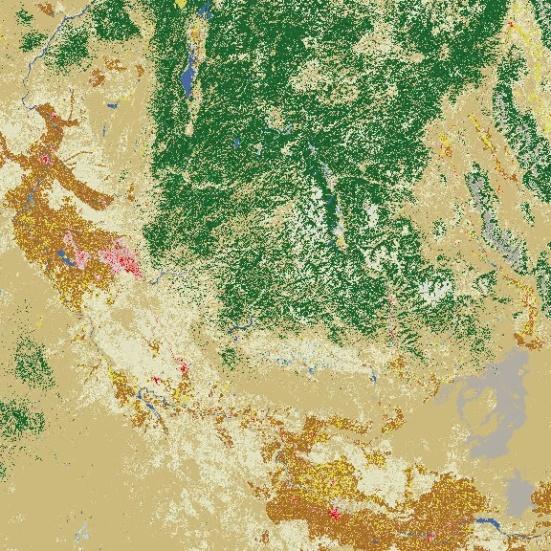
30 FIESTA NFS Prototype Salmon-Challis National Forest, ID Objective: Generate estimates of classified FIA plots using a customized stratification layer Vegetation Dominance Type Canopy Cover Tree and Shrub Size Class

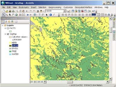
31 FIESTA ArcMap Salmon-Challis NF 31

32 FIESTA ArcMap getfiadata Gets data from FIA DataMart (Includes FIA data tables and summarized tree data). - This data will then need to be classified by R4 folks to different types specific to them (i.e. Dominance types, Stand-size ) Note: - The coordinates from FIA DataMart have been fuzzed to protect the scientific integrity of the plot locations and privacy of landowners (on private land). - For obtaining actual plot coordinates, contact FIA Spatial Data Services (
 by strata.")
33 FIESTA ArcMap getstratdata Gets stratification information from a specified stratification layer. Extracts values from spatial layer and calculates area (in acres) by strata. Output: csv file plots and attached strata value and csv file of area by strata.

 woodland 72,719 22.")
34 FIESTA ArcMap getestarea Calculates area estimates (and variance of estimates) by specified category. Output: csv file with table of estimates (in acres) and % standard error. Estimated acres and standard error by fortypnm on all lands; Idaho; FORTYPNM Estimate Percent Standard Error Nonforest 1,179, Rocky Mountain juniper 6, Douglas-fir 1,320, Ponderosa pine 84, Engelmann spruce 27, Engelmann spruce / subalpine fir 190, Subalpine fir 328, Lodgepole pine 456, Limber pine 36, Whitebark pine 184, Cottonwood 5, Aspen 55, Cercocarpus (mountain brush) woodland 72, Nonstocked 403, Total 4,353,
 and % standard error.")
35 FIESTA ArcMap getesttree Calculates total and per-acre estimates with known variance for specified tree attribute by specified category. Output: csv file with table of estimates (in acres) and % standard error. Estimates (Sample Error) of basal area (sqft) of live trees by fortypnm and stdsznm on forest land; Idaho; STDSZNM FORTYPNM Large diameter Medium diameter Small diameter Nonstocked Total Rocky Mountain juniper 660,792 (105.45) ,792 (105.45) Douglas-fir 104,962,609 ( 7.04) 9,592,253 ( 26.90) 2,563,987 ( 28.50) 0 117,118,849 ( 6.40) Ponderosa pine 5,078,598 ( 34.10) 0 221,969 (105.45) 0 5,300,568 ( 32.93) Engelmann spruce 2,879,731 ( 50.70) ,879,731 ( 50.70) Engelmann spruce / subalpine fir 19,192,389 ( 24.44) 1,245,683 ( 64.13) 1,417,876 ( 48.00) 0 21,855,949 ( 21.76) Subalpine fir 14,831,723 ( 23.16) 6,145,184 ( 33.00) 3,487,983 ( 34.27) 0 24,464,890 ( 16.30) Lodgepole pine 13,727,745 ( 26.92) 20,472,692 ( 19.25) 5,294,401 ( 33.28) 0 39,494,838 ( 13.49) Limber pine 4,826,881 ( 40.99) ,826,881 ( 40.99) Whitebark pine 10,693,609 ( 24.82) 1,000,607 ( 59.38) 1,513,961 ( 48.44) 0 13,208,178 ( 20.91) Cottonwood 0 605,049 (103.02) ,049 (103.02) Aspen 0 103,583 ( 98.52) 686,205 ( 50.71) 0 789,788 ( 49.72) Cercocarpus woodland 2,823,791 ( 44.47) 1,761,044 ( 58.77) 323,564 ( 65.74) 0 4,908,399 ( 29.22) Nonstocked ,286,327 ( 27.26) 1,286,327 ( 27.26) Total 179,677,869 ( 4.92) 40,926,095 ( 12.50) 15,509,947 ( 15.74) 1,286,327 ( 27.26) 237,400,238 ( 3.39)
36 FIESTA ArcMap link Necessary for configuration: ArcGIS Desktop v. >= 10.0 with Python support Install R ( Add file location (full path) of R executable path to Systems Environment variable Path (..or add a parameter to scripts)
 5. Write errors to screen errors = '' for line in p.stdout.readlines(): errors += line retval = p.")
37 FIESTA ArcMap link In Python: 1. Import subprocess module 2. Build process command cmd = "Rscript " + rscript + " " + args 3. Specify location of R executable and location of R script. 4. Execute command using subprocess.popen p = subprocess.popen(cmd, shell=true, stdout=subprocess.pipe, stderr=subprocess.stdout) 5. Write errors to screen errors = '' for line in p.stdout.readlines(): errors += line retval = p.wait()
38 FIESTA ArcMap link In R Script: 1. Load FIESTA package 2. Load R libraries necessary for FIESTA (RODBC, raster, sp, rgeos, maptools, rgdal, sqldf) 3. Get arguments from Python 4. Run FIESTA functions
39 Summary NFS, R&D Collaboration NFS needs include data and estimates (with known variance) for Forest Planning, wildlife habitat assessment, wildfire planning,... FIA has an extensive database of forest inventory data and an unbiased, design-based sample for estimation and variance. FIESTA is an R package developed by R&D with specific use with FIA data to generate area and total tree and per-acre estimates with known variances. ArcMap is a familiar, user-friendly interface to integrate FIESTA estimation tools with ArcMap's spatial manipulation tools.

40 FIESTA ArcMap Next Steps More sophisticated Python scripts Improve R-ArcMap interaction Design prettier user-interface Build ArcMap Add-in tool Get FIESTA package up to CRAN website Tech Transfer Web interface

41 CHEERS? 41
Colorado Front Range Fuel Photo Series
 Colorado Front Range Fuel Photo Series Michael A. Battaglia Jonathan M. Dodson Wayne D. Shepperd Mark J. Platten Owen M. Tallmadge General Technical Report RMRS-GTR-1WWW United States Department of Agriculture
Forest Resources of the Ashley National Forest
 United States Department of Agriculture Forest Service Intermountain Research Station December 1997 Forest Resources of the Ashley National Forest Renee A. O Brien Ronald P. Tymcio This summary of the
Forest Resources of the Uinta National Forest
 United States Department of Agriculture Forest Service Intermountain Research Station August 1997 Forest Resources of the Uinta National Forest Renee A. O Brien Dennis Collins This summary of the forest
Forest Resources of the Beaverhead- Deerlodge National Forest
 United States Department of Agriculture Forest Service Rocky Mountain Research Station August 21 Forest Resources of the Beaverhead- Deerlodge National Forest Larry T. DeBlander Beaverhead-Deerlodge National
Forest Resources of the Wasatch-Cache National Forest
 United States Department of Agriculture Forest Service Intermountain Research Station July 1997 Forest Resources of the Wasatch-Cache National Forest Renee A. O Brien Reese Pope This summary of the forest
Forest Resources of the Fishlake National Forest
 United States Department of Agriculture Forest Service Rocky Mountain Research Station May 1998 Forest Resources of the Fishlake National Forest Renee A. O Brien Shirley H. Waters An extensive, comprehensive
Forest Resources of the Lolo National Forest
 United States Department of Agriculture Forest Service Rocky Mountain Research Station June 2000 Forest Resources of the Lolo National Forest Larry T. DeBlander About the author Larry T. DeBlander is a
Forest Resources of the Black Hills National Forest
 United States Department of Agriculture Forest Service Rocky Mountain Research Station August 22 Forest Resources of the Black Hills National Forest Larry T. DeBlander About the author Larry T. DeBlander
Forest Resources of the Shoshone National Forest
 United States Department of Agriculture Forest Service Rocky Mountain Research Station May 2008 Forest Resources of the Shoshone National Forest Jim Menlove About the author Jim Menlove is an Ecologist
COLE 1605(b) Report for Washington
 Report for Washington") COLE 1605(b) Report for Washington COLE Development Group January 4, 2019 1 Abstract This is a standard report produced by COLE, The Carbon Online Estimator. COLE is an online package that was developed
COLE 1605(b) Report for Washington COLE Development Group January 4, 2019 1 Abstract This is a standard report produced by COLE, The Carbon Online Estimator. COLE is an online package that was developed
Combining Forest Inventory, Satellite Remote Sensing, and Geospatial Data for Mapping Forest Attributes of the Conterminous United States
 Combining Forest Inventory, Satellite Remote Sensing, and Geospatial Data for Mapping Forest Attributes of the Conterminous United States Mark Nelson 1, Greg Liknes 2, and Charles Perry 3 Abstract: Analysis
Forest Resources of the Apache- Sitgreaves National Forest
 United States Department of Agriculture Forest Service Rocky Mountain Research Station September 2003 Forest Resources of the Apache- Sitgreaves National Forest Paul Rogers About the author Paul Rogers
Intermountain Adaptation Partnership. Pat Behrens, USFS Intermountain Region
 Pat Behrens, USFS Intermountain Region Direct effects altered vegetation growth, mortality, and regeneration Indirect effects through altered disturbance and interactions with altered ecosystem processes
Forest Resources of the Coconino National Forest
 United States Department of Agriculture Forest Service Rocky Mountain Research Station May 2003 Forest Resources of the Coconino National Forest Larry T. DeBlander Mark Fleck About the author Larry T.
Forest Resources of the Medicine Bow National Forest
 United States Department of Agriculture Forest Service Rocky Mountain Research Station September 2008 Forest Resources of the Medicine Bow National Forest Jim Steed Wyoming Medicine Bow National Forest
Rocky Mountain Landscape Simulator
 Rocky Mountain Landscape Simulator GIS Database Cover Age Elevation Etc. Wildlife Habitat Suitability Models Initial Condition T1 T2 T3 FRAGSTATS Analysis Disturbance Scenarios Disturbance Processes Anthro
Forest Resources of the Nez Perce National Forest
 United States Department of Agriculture Forest Service Rocky Mountain Research Station July 2010 Forest Resources of the Nez Perce National Forest Michele Disney About the author Michele Disney is a Forestry
Forest Assessments with LiDAR: from Research to Operational Programs
 Forest Assessments with LiDAR: from Research to Operational Programs David L. Evans Department of Forestry Forest and Wildlife Research Center Mississippi State University Forest Remote Sensing: Then and
Predictive Mapping of Forest Attributes on the Fishlake National Forest. Methods. Tracey S. Frescino and Gretchen G. Moisen 1
 Predictive Mapping of Forest Attributes on the Fishlake National Forest Tracey S. Frescino and Gretchen G. Moisen 1 Abstract. Forest land managers increasingly need maps of forest characteristics to aid
Monitoring State Forest Lands in Standardization with a National Forest Inventory Program
 Monitoring State Forest Lands in Standardization with a National Forest Inventory Program James A. Westfall 1 and Charles T. Scott 2 Introduction Within the past decade, there has been increasing interest
OptFuels Vegetation and Fuels Inputs
 OptFuels Vegetation and Fuels Inputs Vegetation and Fuels Overview Spatial Data Inputs for OptFuels Modeling Stand and Fuelbed Dynamics Regeneration Modeling Disturbance Updating (Angora, Past Treatments)
New Sampling Protocols and Data for the National FIA Program
 New Sampling Protocols and Data for the National FIA Program John D. Shaw Interior West Forest Inventory and Analysis USDA Forest Service Interior West FIA User Group Webcast April 13, 2010 What s New
Status and Trends in Forest Habitat Types of the Boreal Hardwood Transition
 Status and Trends in Forest Habitat Types of the Boreal Hardwood Transition Mark D. Nelson U.S. Forest Service Northern Research Station 17 April 2018 Ashland, MN 1 Boreal Hardwood Transition = Bird Conservation
Forest Resources of the Tonto National Forest
 United States Department of Agriculture Forest Service Rocky Mountain Research Station August 2004 Forest Resources of the Tonto National Forest John D. Shaw About the author John D. Shaw is a Forester
Rapid Assessment Reference Condition Model
 R2SFPI Rapid Assessment Reference Condition Model The Rapid Assessment is a component of the LANDFIRE project. Reference condition models for the Rapid Assessment were created through a series of expert
Comprehensive Inventory of Utah s Forest Resources, 1993
 United States Department of Agriculture Forest Service Rocky Mountain Research Station Resource Bulletin RMRS-RB-1 March 1999 Comprehensive Inventory of Utah s Forest Resources, 1993 Renee A. O Brien Abstract
Creating Wildlife Habitat Conditions
 Creating Wildlife Habitat Conditions Dale L Wills TABLE OF CONTENTS INTRODUCTION...245 SUBALPINE FOREST AND DOUGLAS FIR...246 Grass-forb Stage...246 Shrub-seedling Stage...247 Sapling-pole Stage...247
Comparisons of image- and plot-based estimates of number and size of forest patches in Michigan, USA
 Comparisons of image- and plot-based estimates of number and size of forest patches in Michigan, USA Mark D. Nelson 1, Dacia M. Meneguzzo 2, and Mark H. Hansen 3 1 U.S. Department of Agriculture, Forest
USDA FOREST SERVICE/NORTHERN REGION
 USDA FOREST SERVICE/NORTHERN REGION Report No. 1-72-1 5230 April 1972 EVALUATION OF MOUNTAIN PINE BEETLE INFESTATIONS YELLOWSTONE NATIONAL PARK, WYOMING, 1971 by 2Malcolm J. Berg1/ and Mark D. McGregor/
Uncompahgre Mesas Project Area 2015 Monitoring Report
 Uncompahgre Mesas Project Area 15 Monitoring Report This report presents a summary of data from the Uncompahgre Mesas project area. Pre-harvest data were collected on 18 ½ acre plots beginning in 9 ( Original
Rapid Assessment Reference Condition Model
 R0ms Rapid Assessment Reference Condition Model The Rapid Assessment is a component of the LANDFIRE project. Reference condition models for the Rapid Assessment were created through a series of expert
National forest inventory and
 National forest inventory and monitoring in the USA Thomas J. Brandeis, PhD. USDA Forest Service, Forest Inventory and Analysis With material contributed by William Burkman (SRS FIA), Brad Smith (FIA WO),
Mixed Conifer Forest Classification
 Mixed Conifer Forest Classification USFS SW Region Desired Conditions and Forest Plans October 2016 Sacramento Mountains Desired Conditions Workshop OBJECTIVES Describe dry and wet mixed conifer forests,
An Analysis of Forest Fire History on the Little Firehole River Watershed, Yellowstone National Park
 University of Wyoming National Park Service Research Center Annual Report Volume 1 1st Annual Report, 1977 Article 16 1-1-1977 An Analysis of Forest Fire History on the Little Firehole River Watershed,
Forecasting Timber, Biomass, and Tree Carbon Pools with the Output of State and Transition Models
 Proceedings of the First Landscape State-and-Transition Simulation Modeling Conference, June 14 16, 2011 Forecasting Timber, Biomass, and Tree Carbon Pools with the Output of State and Transition Models
Simulating Regeneration Dynamics in Upland Oak Stands
 Simulating Regeneration Dynamics in Upland Oak Stands Powered By Powered by: USDA Forest Service Southern Research Station Dr. David Loftis Powered By Powered by: Regen for Excel is a simulation model
Dear Interested Party;
 United States Department of Agriculture Forest Service Caribou-Targhee National Forest Curlew National Grassland Westside Ranger District 4350 Cliffs Drive Pocatello, ID 83204 (208) 236-7500 File Code:
Sustainable Forest Management
 Sustainable Forest Management 2015 Facts & Statistics Spring 2017 ISBN 978-1-4601-3520-4 ISSN 2368-4844 Agriculture and Forestry Annual Allowable Cut Sustainable forest management requires long-term planning.
PHOTO GUIDE FOR APPRAISING DOWNED WOODY MASTICATED FUELS IN INTERIOR PONDEROSA PINE FORESTS ON THE COLORADO FRONT RANGE
 PHOTO GUIDE FOR APPRAISING DOWNED WOODY MASTICATED FUELS IN INTERIOR PONDEROSA PINE FORESTS ON THE COLORADO FRONT RANGE PART ONE OF A FOUR-PART SERIES ON INTERIOR PONDEROSA PINE, GAMBEL OAK, MIXED CONIFER
Reshaping Nature: Climate Change in the Blue Mountains and Beyond. Dave Peterson U.S. Forest Service Pacific Northwest Research Station
 Reshaping Nature: Climate Change in the Blue Mountains and Beyond Dave Peterson U.S. Forest Service Pacific Northwest Research Station Weather vs. Climate Weather refers to day-to-day changes in temperature,
Accuracy assessment of the vegetation continuous field tree cover product using 3954 ground plots in the south-western USA
 International Journal of Remote Sensing Vol. 26, No. 12, 20 June 2005, 2699 2704 Accuracy assessment of the vegetation continuous field tree cover product using 3954 ground plots in the south-western USA
Forest Resources of the United States, 2017: A Technical Document Supporting the Forest Service Update of the 2010 RPA Assessment
 Forest Resources of the United States, 2017: A Technical Document Supporting the Forest Service Update of the 2010 RPA Assessment Abstract Oswalt, Sonja N.; Miles, Patrick D.; Pugh, Scott A.; Smith, W.
Forest Resources of the United States, 2017:
 Forest Resources of the United States, 2017: A Technical Document Supporting the Forest Service 2020 update of the RPA Assessment Abstract Oswalt, Sonja N.; Miles, Patrick D.; Pugh, Scott A.; Smith, W.
Native Bark Beetles in the Western United States: Who, Where, and Why
 Native Bark Beetles in the Western United States: Who, Where, and Why Barbara J. Bentz Rocky Mountain Research Station USDA Forest Service Logan, UT Photo Ryan Bracewell Forest and Woodland Ecosystem Research
Mapping the Cheatgrass-Caused Departure From Historical Natural Fire Regimes in the Great Basin, USA
 Mapping the Cheatgrass-Caused Departure From Historical Natural Fire Regimes in the Great Basin, USA James P. Menakis 1, Dianne Osborne 2, and Melanie Miller 3 Abstract Cheatgrass (Bromus tectorum) is
INNOVATIVE WOODY BIOMASS RESOURCE ASSESSMENT USING MULTIPLE RESOLUTION SATELLITE IMAGERY AND GEOBIA TECHNOLOGY
 INNOVATIVE WOODY BIOMASS RESOURCE ASSESSMENT USING MULTIPLE RESOLUTION SATELLITE IMAGERY AND GEOBIA TECHNOLOGY J. W. San Souci a a NCDC Imaging, 1235 Lake Plaza Drive, Suite 127, Colorado Springs, CO,
Forest Health Monitoring
 Steven Kuzma Forest Health Monitoring Program Overview Borys M. Tkacz National Program Manager Forest Health Monitoring Program Initiated in 1990 to provide information on the status, changes, and trends
SILVICULTURE SILVICULTURE 10/8/2018. Ecological forestry (Ecosystem management)
") SILVICULTURE SILVICULTURE Dave Peterson University of Washington School of Environmental and Forest Sciences Thanks to Kristi McClelland, Boyd Evison, and Greg Ettl Silviculture The science and art of
SILVICULTURE SILVICULTURE Dave Peterson University of Washington School of Environmental and Forest Sciences Thanks to Kristi McClelland, Boyd Evison, and Greg Ettl Silviculture The science and art of
8.0 Forest Assessment Methods
 8.0 Forest Assessment Methods 8.1 Multiple Resource Inventory The type of information needed for the management of any forest includes a multitude of resource values. Gaining this information has stimulated
Overview. United States Department of Agriculture. Sampling error (percent) Sampling error (percent)
 Sampling error (percent)") United States Department of Agriculture This resource update provides an overview of forest resources in Nebraska based on inventories conducted by the USDA Forest Service, Forest Inventory and Analysis
United States Department of Agriculture This resource update provides an overview of forest resources in Nebraska based on inventories conducted by the USDA Forest Service, Forest Inventory and Analysis
Mountain Shadows June 23, 2012
 FIREWISE PRINCIPLES Mountain Shadows June 23, 2012 Fire Behavior and Firewise: 1) You can t change the topography ; 2) Everybody talks about the weather, but nobody does anything about it ; ----Mark Twain
Forest Health Monitoring Program Overview
 Forest Health Monitoring Program Overview Borys M. Tkacz National Program Manager Forest Health Monitoring Program Initiated in 1990 to provide information on the status, changes, and trends in forest
ANALYZING REGIONAL FIA DATA IN THE ARCVIEW GEOGRAPHIC INFORMATION SYSTEM 1
 ANALYZING REGIONAL FIA DATA IN THE ARCVIEW GEOGRAPHIC INFORMATION SYSTEM 1 David Reed, Scott Pugh, Pat Miles, and Kurt Pregitzer 2 Abstract The ArcView Geographic Information System (GIS) is probably the
The GB National Forest Inventory
 The GB National Forest Inventory NFI design 1. Forest Map 2. 15,000 one Ha Survey Squares 3. Map + Squares brought together in the NFI DB 4. Survey Square details multiplied up to the NFI map area X GB
A Stem-map Model for Predicting Tree Canopy Cover of Forest Inventory and Analysis (FIA) Plots
 Plots") A Stem-map Model for Predicting Tree Canopy Cover of Forest Inventory and Analysis (FIA) Plots Chris Toney 1, John D. Shaw 2, and Mark D. Nelson 3 Abstract: Tree canopy cover is an important stand characteristic
A Stem-map Model for Predicting Tree Canopy Cover of Forest Inventory and Analysis (FIA) Plots Chris Toney 1, John D. Shaw 2, and Mark D. Nelson 3 Abstract: Tree canopy cover is an important stand characteristic
Adapting to Climate Change in Western National Forests
 Adapting to Climate Change in Western National Forests David L. Peterson 1, Jessica E. Halofsky 2, Natalie Little 3 ¹USDA Forest Service, Pacific Northwest Research Station ²University of Washington, School
South Dakota's Forest Resources in 2002
 United States Department of Agriculture Forest Service North Central Research Station South Dakota's Forest Resources in 2002 Ronald J. Piva, Douglas Haugan, Gregory J. Josten, and Gary J. Brand Resource
Ecosystem Management (EM) and Historical Range of Variability (HRV)
 and Historical Range of Variability (HRV)") Geog 4430 Ecosystem Management (EM) and Historical Range of Variability (HRV) Brief introduction to general concepts Ecosystem Management (EM) Ecosystem management is management that acknowledges the importance
Geog 4430 Ecosystem Management (EM) and Historical Range of Variability (HRV) Brief introduction to general concepts Ecosystem Management (EM) Ecosystem management is management that acknowledges the importance
Forest biomass by component for the coterminous United States Forest Products Society International Convention June 20, 2010 Madison, WI Pat Miles
 Forest biomass by component for the coterminous United States Forest Products Society International Convention June 20, 2010 Madison, WI Pat Miles Outline 1. FIA sample design 2. Biomass components pre-aug
Descriptive Statistics of Tree Crown Condition in the United States Interior West
 United States Department of Agriculture Forest Service Southern Research Station Descriptive Statistics of Tree Crown Condition in the United States Interior West KaDonna C. Randolph and Mike T. Thompson
Mackenzie Timber Supply Area
 Mackenzie Timber Supply Area TSA16 Vegetation Resources Inventory Project Implementation Plan for Ground Sampling and Net Volume Adjustment Factor Sampling Nona Phillips Forestry Consulting June 12, 2011
U.S. Forest Facts and Historical Trends
 Errata In the printed version of this brochure the graphics on page 13 should be in Billion cubic feet. The following pdf version of the brochure has been corrected. U.S. Forest Facts and Historical Trends
REVISED BIOLOGICAL ASSESSMENT FOR TERRESTRIAL WILDLIFE SPECIES. Benchmark Hazardous Fuels Reduction Project
 REVISED BIOLOGICAL ASSESSMENT FOR TERRESTRIAL WILDLIFE SPECIES Benchmark Hazardous Fuels Reduction Project Rocky Mountain Ranger District Lewis and Clark National Forest Prepared By: Wendy C Maples, District
BOISE FOREST COALITION MEETING BOGUS BASIN UPDATE
 BOISE FOREST COALITION MEETING BOGUS BASIN UPDATE WELCOME AND INTRODUCTIONS Idaho Department of Fish and Game 600 S. Walnut, Boise, Idaho Trophy Room October 15, 2015 Facilitators, Dick Gardner and Jim
Prince George Forest District
 Prince George Forest District Vegetation Resources Inventory Strategic Inventory Plan PREPARED BY: MINISTRY OF FORESTS RESOURCES INVENTORY BRANCH 3 JANUARY 2000 VSIP: Prince George Forest District Page
APPENDIX 2 -- EASTERN U.S. SITE-TREE SELECTION CRITERIA AND FIA FOREST TYPE ALGORITHM FOR THE U.S. EASTERN U.S. SITE-TREE SELECTION CRITERIA
 rtheast Field Guide, Version 1.7 APPENDIX 2 -- EASTERN U.S. SITE-TREE SELECTION CRITERIA AND FIA FOREST TYPE ALGORITHM FOR THE U.S. EASTERN U.S. SITE-TREE SELECTION CRITERIA Ideally, site trees in the
Appendix 5A Priority Landscapes GIS Analysis Methodology
 Appendix 5A Priority Landscapes GIS Analysis Methodology Overview This appendix describes the methodology used for Pennsylvania s Priority Landscapes GIS Analysis. The figure below is a conceptual diagram
Forest Inventory Data
 Forest Inventory Data Greg Reams FIA National Program Leader Washington, DC Jeff Turner Forester Southern Research Station Knoxville, TN Agenda Brief History of FIA Current FIA Program Phase 1: Stratification
Minnesota Forestry Research Notes Published by the Department of Forest Resources, University of Minnesota, St. Paul
 Minnesota Forestry Research Notes Published by the Department of Forest Resources, University of Minnesota, St. Paul 201 No. 30 Evaluating Old Age for Forests in Minnesota from Forest Inventory Records
National Insect and Disease Risk Map Status, Results, and Future
 National Insect and Disease Risk Map Status, Results, and Future Presented by: Frank Krist And Jim Ellenwood Forest Health Technology Enterprise Team Fort Collins, Co Overview 2006 National Insect and
SDI-Flex: A New Technique of Allocating Growing Stock for Developing Treatment Prescriptions in Uneven-Aged Forest Stands 1
 SDI-Flex: A New Technique of Allocating Growing Stock for Developing Treatment Prescriptions in Uneven-Aged Forest Stands 1 Wayne D. Shepperd 2 Abstract One of the difficulties of apportioning growing
The Influence of Stand Density on Mortality in California s Forests
 The Influence of Stand Density on Mortality in California s Forests An Analysis of Inventory Data Michael Landram Regional Silviculturist, USDA Forest Service, R-5 Contributors and Collaborators Ralph
Fire History in the Colorado Rockies
 Fire History in the Colorado Rockies Brief overview of fire regimes in different forest ecosystem types Relationship of wildfire activity to climate variability Effects of fire exclusion and fire suppression
Cooper Creek ECS Ecological Departure Analysis
 Cooper Creek ECS Ecological Analysis Methods: - LIDAR derived Canopy height and canopy density data obtained from Luis Miguel Verissimo of Michigan Tech university - LIDAR derived Canopy Height/Density
Mixed Conifer Forests An Overview
 Mixed Conifer Forests An Overview Thomas Spies PNW Research Station December 4, 2013 Pendleton, OR "Ecosystems are not only more complex than we think, but more complex than we can think. ---Frank Egler
Effects of Climatic Variability and Change on Vegetation and Disturbance in the Blue Mountains
 Effects of Climatic Variability and Change on Vegetation and Disturbance in the Blue Mountains Becky Kerns, John Kim, and Dave Peterson USFS Pacific Northwest Research Station Climate Change and Vegetation
Report on the potential application of CFLRP monitoring tools for development of Forest Plan monitoring
 FINAL REPORT For project task (#2) 5 January 2018 Report on the potential application of CFLRP monitoring tools for development of Forest Plan monitoring In partial fulfillment of USFS-CSU Agreement #12-CS-1
Wildlife Habitat Models Methodology and Process Steps
 Wildlife Habitat Models Methodology and Process Steps Wildlife Habitat Analysis ABSTRACT: A deductive habitat model based on Gradient Nearest Neighbor (GNN), Wildlife Habitat Relationships (WHR), and habitat
Dear Interested Party,
 United States Department of Agriculture Forest Service Gunnison Ranger District 216 N Colorado St. Gunnison, CO 81230 Voice: 970-641-0471 TDD: 970-641-6817 File Code: 1950-1/2430 Date: June 8, 2010 Dear
A Comparison of Two Estimates of Standard Error for a Ratio-of-Means Estimator for a Mapped-Plot Sample Design in Southeast Alaska
 United States Department of Agriculture Forest Service Pacific Northwest Research Station Research Note PNW-RN-532 June 2002 A Comparison of Two Estimates of Standard Error for a Ratio-of-Means Estimator
(800)
") PACIFIC NORTHWEST AGRICULTURAL SAFETY AND HEALTH (PNASH) CENTER fishing farming forestry Promoting Safe and Sustainable Agricultural Workplaces and Communities http://depts.washington.edu/pnash pnash@uw.edu
PACIFIC NORTHWEST AGRICULTURAL SAFETY AND HEALTH (PNASH) CENTER fishing farming forestry Promoting Safe and Sustainable Agricultural Workplaces and Communities http://depts.washington.edu/pnash pnash@uw.edu
FMU C5 FOREST MANAGEMENT PLAN
 FMU C5 FOREST MANAGEMENT PLAN Development of the Preferred Forest Management Scenario Prepared By: The Forestry Corp. May 26, 2006 EXECUTIVE SUMMARY A timber supply analysis (TSA) for the C5 Forest Management
Big Hill Insect and Disease Project Proposed Action
 Big Hill Insect and Disease Project Proposed Action Project Background and 2014 Farm Bill The Big Hill Insect and Disease project on the Challis-Yankee Fork Ranger District of the Salmon-Challis National
Lillooet Forest District. Inventory Plan
 Lillooet Forest District Inventory Plan MINISTRY OF FORESTS RESOURCES INVENTORY BRANCH JUNE 1998 Table of Contents 1. INTRODUCTION...1 1.1 Background...1 1.2 Objectives...2 2. BUSINESS CONSIDERATIONS...3
Forest Resources of the Umatilla National Forest
 DE PA RTMENT OF AGRICULT URE United States Department of Agriculture Forest Service Pacific Northwest Research Station Resource Bulletin PNW-RB-253 May 2007 Forest Resources of the Umatilla National Forest
Appendix A: Vegetation Treatment Descriptions and Unit Specific Design Criteria
 Appendix A: Vegetation Treatment Descriptions and Unit Specific Design Criteria The table below describes the Kabetogama Project proposed vegetation treatments associated with Alternative 2. The treatment
New Mexico s Forest Products Industry
 Sacramento Mountain Wood Industry Summit March 31, 2016 New Mexico s Forest Products Industry Steve Hayes, CF Eric Simmons Bureau of Business and Economic Research University of Montana BBER-who, what,
Development of a Northern Goshawk Habitat Suitability Index for Forest Types of the Kootenay Region
 Development of a Northern Goshawk Habitat Suitability Index for Forest Types of the Kootenay Region Marlene M. Machmer Pandion Ecological Research Limited 705 Stanley Street, Nelson, BC, V1L 1N6 Canada
Bioe 515. Disturbance and Landscape Dynamics
 Bioe 515 Disturbance and Landscape Dynamics The Rocky Mountains, Lander's Peak, 1863 Albert Bierstadt (American, 1830 1902) 1895 Natural Disturbance? 1980 Fire Exclusion? Disturbance Cannot be Ignored
Based on historical fire patterns, what areas of the Clearwater National Forest currently have the greatest probability of a large fire (>10 acres)?
?") http://www.fs.fed.us/r1/clearwater/ Jena Ferrarese Ludger Wöhrmann GIS II Winter 2010 8 March 2010 Based on historical fire patterns, what areas of the Clearwater National Forest currently have the greatest
http://www.fs.fed.us/r1/clearwater/ Jena Ferrarese Ludger Wöhrmann GIS II Winter 2010 8 March 2010 Based on historical fire patterns, what areas of the Clearwater National Forest currently have the greatest
DRAFT. Vanderhoof Forest District. Documentation of Analysis for Vegetation Resources Inventory Statistical Adjustment
 i Vanderhoof Forest District Documentation of Analysis for Vegetation Resources Inventory Statistical Adjustment DRAFT November 28 ii EXECUTIVE SUMMARY Timberline Natural Resource Group recently completed
Regional Patterns of Dead Wood in Forested Habitats of Oregon and Washington 1
 Regional Patterns of Dead Wood in Forested Habitats of Oregon and Washington 1 Janet L. Ohmann and Karen L. Waddell 3 Abstract We describe regional patterns of variation in dead wood across 0 million ha
Forest Change Caused by Wind, Water, Ice, Fire, Insects/Disease & Harvesting
 Forest Change Caused by Wind, Water, Ice, Fire, Insects/Disease & Harvesting Why use remote sensing for mapping forest changes? Synoptic view of damage on a forest landscape or regional level. Can stop
Wildlife Conservation Strategy
 Wildlife Conservation Strategy Boise National Forest What is the Wildlife Conservation Strategy? The Boise National Forest is developing a Wildlife Conservation Strategy (WCS) in accordance with its Land
Mapping burn severity in heterogeneous landscapes with a relativized version of the delta Normalized Burn Ratio (dnbr)
") Mapping burn severity in heterogeneous landscapes with a relativized version of the delta Normalized Burn Ratio (dnbr) Jay D. Miller USDA Forest Service 3237 Peacekeeper Way McClellan, CA 95652 Email:
Mapping burn severity in heterogeneous landscapes with a relativized version of the delta Normalized Burn Ratio (dnbr) Jay D. Miller USDA Forest Service 3237 Peacekeeper Way McClellan, CA 95652 Email:
Parameter Year Montana Idaho , , , ,597
 Montana/Idaho Wildfire Carbon Emissions Inventory Wildfire carbon emissions were calculated for Idaho and Montana for 13 through 17. The results are shown in the Table 1 and Figure 1. To allow further
Overview. United States Department of Agriculture
 This resource update provides an overview of forest resources in Kansas based on inventories conducted by the U.S. Forest Service, Forest Inventory and Analysis (FIA) program of the Northern Research Station.
Assessing and Adapting to Climate Change Intermountain Region. Natalie Little Forest Service Ogden, Utah
 Assessing and Adapting to Climate Change Intermountain Region Natalie Little Forest Service Ogden, Utah We have lots of information! Adapting to climate change: USFS information & tools Climate Change
Development of State and Transition Model Assumptions Used in National Forest Plan Revision
 Development of State and Transition Model Assumptions Used in National Forest Plan Revision Eric B. Henderson 1 Abstract State and transition models are being utilized in forest management analysis processes