The following paragraphs provide a bulleted summary of the items discussed during the meeting:
|
|
|
- Camilla Holland
- 6 years ago
- Views:
Transcription


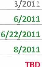
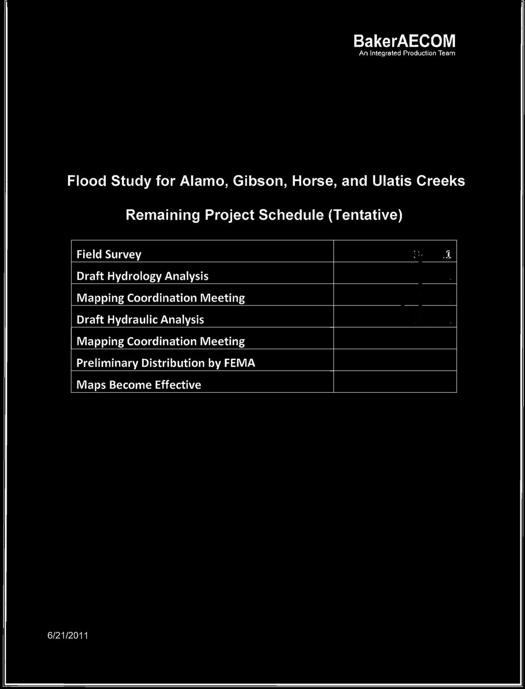
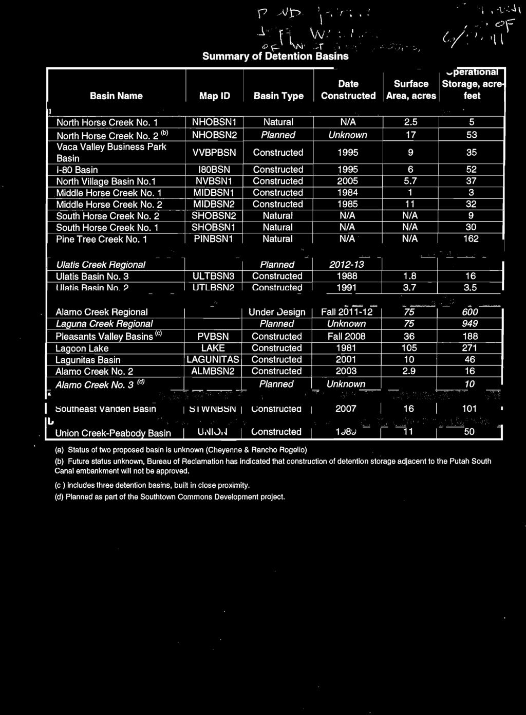
1 minutes Flood Insurance Study Update Meeting City of Vacaville Public Works Conference Room #2 650 Merchant Street Vacaville, California June 22, :00 a.m. 12:00 p.m. ATTENDEES: Tim Burke, Public Works, City of Vacaville Jeff Wanlass, West Yost Associates Eric Simmons, FEMA Region IX Lee Brancheau, BakerAECOM Mark Delorey, BakerAECOM PURPOSE: The community meeting regarding the FEMA s Flood Insurance study for the city of Vacaville was held on June 22, 2011, with representatives from the city of Vacaville, FEMA Region IX, West Yost Associates, and BakerAECOM. FEMA is restudying Gibson Canyon, Horse, Ulatis, and Alamo Creeks. This restudy affects the city of Vacaville and the unincorporated areas of Solano County. Other topics discussed during this meeting included the Sweeney Creek Flood Study and the New Look products. The following paragraphs provide a bulleted summary of the items discussed during the meeting: FEMA funded the Vacaville Flood Insurance Study in response to a request from the city of Vacaville due to significant changes in the watersheds since the effective studies were completed. Outreach was performed approximately 2 years ago for new Zone A areas. This outreach was performed prior to the issuance for the Solano Countywide DFIRM. Large Zone A areas added at the request of the city during Map Mod along Alamo Creek and Elmira. The preliminary and effective dates for the revised FIRM panel and FIS Report are TBD. FEMA plans to fund the mapping at a later date. Draft modeling/ mapping can be used for floodplain management purposes. The Draft Hydrology Report is available online at Vacaville requested that BFE be added for large zone A s for the purposes of Elevation Certificates (E.C.) The City of Vacaville and West Yost Associates have data that they can share with BakerAECOM. Data includes modeling and surveys along Alamo, Ulatis, and Horse Creeks. There has been 16 detention basins either completed or being built since the original Flood studies were conducted. The City would like the detention basins to be incorporated into the new Page 1 BakerAECOM, LLC members: Michael Baker Jr., Inc.; AECOM; Taylor Engineering, Inc.; and Gannett Fleming, Inc.
2 minutes flood study. A list of detention basins by watershed was provided to FEMA and BakerAECOM at the meeting. The City of Vacaville is going through the NEPA process on a few of the remaining detention basins which are 99% designed. At this point there are three new detention basins that should be complete by These include North Horse Creek No. 2, Ulatis Creek Regional, and Laguna Creek Regional. 100% of the basins have been modeled with HEC-1. There was also a watershed-wide study conducted in 2008 as a result of the 2005 floods. FEMA would like to obtain the modeling so that the available detention basins and watershed boundaries can be used to update the FEMA model. FEMA requested a formal response to the hydrology report. FEMA would like to get the community s blessing on the modeling prior to finalizing the report. Basin on the availability of community hydrologic information mentioned at the meeting, it was determined that the hydrology report will need to be revised due to; (1) missing detention basins and (2) need to update the watershed boundaries. The City reports flows being significantly lower in the eastern part of the City due to the operational storage of the 16 basins which were unknown to FEMA and its contractors during the scoping and hydrologic analysis stages of the project. There are 5 city gauges that were used to calibrate the city model. The city pointed out some items to consider; (1) detention basins; (2) overbank flooding which occurred during the 2002 and 2005 storms. During the 2005 storm the overbank flooding occurred during a year storm; (3) Several recent LOMRs; (4) there is no a longer a levee downstream of Alamo Creek. Best way to provide all available data is digitally. The city can provide the watershed files shortly. The detention basin storage data will take a few months. West Yost Associates noted that there are system-wide hydrologic models for each of the four watersheds, and these were developed of the current FEMA effective HEC-1 models. Planned meeting in fall to discuss hydraulic modeling. The following are few ways outreach can be conducted: 1. Fact Sheet 2. Website 3. Formal Letter 4. Meetings 5. Conference Calls 6. Web-ex FEMA should notify the Solano County Water Agency (SCWA) of ongoing flood studies. David Okita and Thomas Pate should be contacted. The Sweeney Creek restudy was discussed briefly. This study will affect the unincorporated areas of the Solano County. The change map for this area reflected mostly increases. The Sweeney Creek restudy is also being used as a FEMA nationwide prototype for a New Look map. The city liked the new colors and transparencies. The pilot products are digitally available on the Region IX website at Some of the advantages of the new products include the following: 1. Additional colors (FEMA is no longer limited by the Government Printing Office); 2. The pixel hatching for the flood zones has been replaced by solid shading; Page 2 BakerAECOM, LLC members: Michael Baker Jr., Inc.; AECOM; Taylor Engineering, Inc.; and Gannett Fleming, Inc.
3 minutes 3. Ability to create the FIS report and FIRM panels from the DFIRM database; 4. A more tabular FIS report that includes more dates; 5. Label and BFE lines reduced; 6. Fewer Notes to Users; 7. More precise water-surface elevations at each cross section; and 8. New panel size (the proposed standard panel will be size D, which will make it easier for local communities to print their own panels). ACTION ITEMS: Action Items for FEMA: FEMA to discuss NEPA application with David Connard (sp?), the grants branch chief at FEMA Region IX. (This issue has been resolved). FEMA to update SCWA on the new Solano County flood studies. Action Items for the City of Vacaville West Yost: Provide FEMA with the watershed boundary. (Provided by West Yost on 7/27/2011) Provide FEMA with the available modeling and detention pond data. (Some data provided 7/27/2011 as listed below, and additional data was provided on 9/2/2011). City storm drain maps in AutoCAD Ulatis Creek Drainage Study 2008 Ulatis Creek Analysis 2008 HEC1 models developed for the Ulatis Creek Drainage Study (seems to include HEC-1 for Alamo, Horse, Gibson also) ATTACHMENT Attendance Sign-in Sheet Page 3 BakerAECOM, LLC members: Michael Baker Jr., Inc.; AECOM; Taylor Engineering, Inc.; and Gannett Fleming, Inc.


4
5


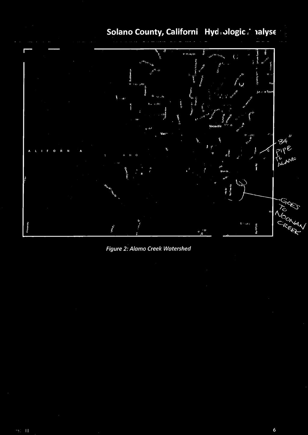
6
7


8


9
10
11
12
13
14
15
16
17
18
19
20
21
22
23
24
25
26


27


28

29


30


31


32


33


34
Flood Insurance Study
 Flood Insurance Study Caddo Parish, Louisiana Kick-Off Meeting May 4, 2010 Presentation Overview Introduction FEMA Risk Map Update Levee Discussion Study Discussion Information Resources Review Contact
Stormwater Management Studies PDS Engineering Services Division ES Policy # 3-01
 Stormwater Management Studies PDS Engineering Services Division Revised Date: 2/28/08 INTRODUCTION The City of Overland Park requires submission of a stormwater management study as part of the development
THE CROSSROADS IN WINCHESTER 4. DRAINAGE PLAN. 4. Drainage Plan. a. Drainage Plan Description
 THE CROSSROADS IN WINCHESTER 4. DRAINAGE PLAN 4. Drainage Plan a. Drainage Plan Description The Specific Plan area drains naturally into two separate watersheds: approximately 6 percent of the Specific
JACKSON COUNTY, GEORGIA AND INCORPORATED AREAS
 Jackson County JACKSON COUNTY, GEORGIA AND INCORPORATED AREAS COMMUNITY NAME COMMUNITY NUMBER ARCADE, CITY OF 130597 BRASELTON, TOWN OF 130343 COMMERCE, CITY OF 130212 HOSCHTON, CITY OF 130344 JACKSON
Risk MAP in Louisiana Louisiana Floodplain Management Association. Shona Gibson, PE Risk Analysis FEMA Region VI April 29, 2010
 in Louisiana Louisiana Floodplain Management Association Shona Gibson, PE Risk Analysis FEMA Region VI April 29, 2010 Overview Paradigm Shift Vision Program Goals and Measures Project Selection Process
DRAFT. Jacob Torres, P.E.; Nick Fang, Ph.D., P.E.
 \ Memorandum SSPEED Center at Rice University Department of Civil & Environmental Engineering 6100 Main MS-317 Houston, Texas 77005-1827 sspeed.rice.edu tel: 713-348-4977 To Andy Yung, P.E. CFM; Lane Lease,
STORMWATER MANAGEMENT LEGISLATION IN COOK COUNTY (P.A )
") STORMWATER MANAGEMENT LEGISLATION IN COOK COUNTY (P.A. 093-1049) Summary of the Act In November 2004, the responsibility of Stormwater Management* in Cook County was placed under the authority of the MWRDGC
STORMWATER MANAGEMENT LEGISLATION IN COOK COUNTY (P.A. 093-1049) Summary of the Act In November 2004, the responsibility of Stormwater Management* in Cook County was placed under the authority of the MWRDGC
TIFT COUNTY, GEORGIA AND INCORPORATED AREAS. Tift County. Revised: September 29, 2010 FLOOD INSURANCE STUDY NUMBER 13277CV000A
 TIFT COUNTY, GEORGIA AND INCORPORATED AREAS Community Name Community Number Tift County OMEGA, CITY OF 130552 TIFT COUNTY (UNINCORPORATED AREAS) 130404 TIFTON, CITY OF 130171 TY TY, CITY OF 130172 Revised:
HEC-RAS 2D Modeling in Support of Ascension Parish Levee Certification
 HEC-RAS 2D Modeling in Support of Ascension Parish Levee Certification OFMA 2017 Annual Conference September 19, 2017 Presented by: Jeff Doudrick, PE, ENV SP Project Manager HNTB Corporation Agenda Project
Appendix G: Hydrology-Related Reports
 Appendix G: Hydrology-Related Reports (Hydraulic Summary of the Proposed Hawk Street Bridge, Bay Area Hydrology Model Project Report, Preliminary Stormwater Treatment Plan and Details, Evaluation of Potential
St.Vrain Watershed (Boulder County), Colorado. Hydrologic Data Development Technical Support Data Notebook
, Colorado. Hydrologic Data Development Technical Support Data Notebook") Hydrologic Data Development Technical Support Data Notebook St.Vrain Watershed (Boulder County), Colorado FEMA Grant EMD-2011-GR-1182 MIP Case#: 15-08-1150S March 17, 2016 Federal Emergency Management
Hydrologic Data Development Technical Support Data Notebook St.Vrain Watershed (Boulder County), Colorado FEMA Grant EMD-2011-GR-1182 MIP Case#: 15-08-1150S March 17, 2016 Federal Emergency Management
SAN BRUNO CREEK / COLMA CREEK RESILIENCY STUDY FINAL REPORT
 SAN BRUNO CREEK / COLMA CREEK RESILIENCY STUDY FINAL REPORT Prepared for: San Francisco International Airport RFP: 8354.1 Prepared by: August 2015 M&N Job No: 7981 Final Report Page E-1 EXECUTIVE SUMMARY
FLOOD INSURANCE STUDY
 FLOOD INSURANCE STUDY DONA ANA COUNTY, NEW MEXICO AND INCORPORATED AREAS VOLUME 1 OF 2 COMMUNITY NAME COMMUNITY NUMBER ANTHONY, TOWN OF 350061 DONA ANA COUNTY 350012 (UNINCORPORATED AREAS) HATCH, VILLAGE
NEW CASTLE COUNTY, DELAWARE, AND INCORPORATED AREAS
 NEW CASTLE COUNTY, DELAWARE, AND INCORPORATED AREAS Community Name Community Number ARDEN, VILLAGE OF 100052 *AREDENCROFT, VILLAGE OF 100057 ARDENTOWN, VILLAGE OF 100058 *BELLEFONTE, TOWN OF 100021 DELAWARE
JEFFERSON COUNTY, WISCONSIN, AND INCORPORATED AREAS
 VOLUME 1 OF 2 JEFFERSON COUNTY, WISCONSIN, AND INCORPORATED AREAS Community Name Community Number Cambridge, Village of 550080 Fort Atkinson, City of 555554 Jefferson, City of 555561 Jefferson County,
CARROLL COUNTY, GEORGIA
 CARROLL COUNTY, GEORGIA AND INCORPORATED AREAS Community Name Community Number BOWDON, CITY OF 130244 CARROLL COUNTY 130464 (UNINCORPORATED AREAS) CARROLLTON, CITY OF 130208 MOUNT ZION, CITY OF 130286
ADVANCED APPLICATIONS OF HEC-HMS
 Hydrologic Engineering Center Training Course on ADVANCED APPLICATIONS OF HEC-HMS 18 22 April 2016 Davis, California Course Objectives The course covers a variety of areas that go beyond the Basic HEC-HMS
CLEVELAND COUNTY, OKLAHOMA AND INCORPORATED AREAS VOLUME 1 OF 3
 CLEVELAND COUNTY, OKLAHOMA AND INCORPORATED S VOLUME 1 OF 3 PRELIMINARY SEPTEMBER 30, 2011 Community Name Community Number CLEVELAND COUNTY, UNINCORPORATED S 400475 LEXINGTON, CITY OF 400043 MOORE, CITY
June 22, Francis E. Borcalli, P.E.
 CACHE CREEK SETTLING BASIN SYMPOSIUM Managing the Settling Basin Who s Doing What! June 22, 2009 Francis E. Borcalli, P.E. CACHE CREEK SETTLING BASIN SYMPOSIUM Managing the Settling Basin Who s Doing What!
APPENDIX H Guidance for Preparing/Reviewing CEQA Initial Studies and Environmental Impact Reports
 APPENDIX H H.1 Guidance for Preparing and Reviewing CEQA Initial Studies Step 1: Consider the Project Characteristics as Provided by the Project Applicant Review the project application and draft plan
Panel Decision & Report. SRP ORWB Beaverton, Washington County, OR
 Panel SRP ORWB080414 - Beaverton, Washington County, OR November 2, 2015 Table of Contents SUMMARY... 2 INTRODUCTION... 2 PANEL... 2 BASIS FOR THE COMMUNITY S CHALLENGE... 4 DATA SUBMITTED BY THE COMMUNITY
Coordinated Hazard Assessment and Mapping Program
 Coordinated Hazard Assessment and Mapping Program Mississippi River flood, 1993 A PREDICTABLE DISASTER Floods are the most common natural disaster in Illinois, accounting for well over 90% of declared
CITY OF REDLANDS MASTER PLAN OF DRAINAGE San Bernardino County, California
 CITY OF REDLANDS MASTER PLAN OF DRAINAGE San Bernardino County, California Prepared for City of Redlands 35 Cajon Street Redlands, California 92373 Prepared by 14725 Alton Parkway Irvine, CA 92618 Contact
DRAINAGE PLAN OF NAU S EASTBURN EDUCATION AND GAMMAGE BUILDINGS FINAL PROPOSAL
 MAY 10, 2016 DRAINAGE PLAN OF NAU S EASTBURN EDUCATION AND GAMMAGE BUILDINGS FINAL PROPOSAL Connor Klein, Jiangnan Yi, Yuzhi Zhang, Yi Yang NORTHERN ARIZONA UNIVERSITY NAU Water Buffalo Engineering Table
MODOC COUNTY, CALIFORNIA
 MODOC COUNTY, CALIFORNIA AND INCORPORATED AREAS COMMUNITY NAME COMMUNITY NUMBER ALTURAS, CITY OF 060193 MODOC COUNTY (UNINCORPORATED AREAS) 060192 REVISED: PRELIMINARY: FEBRUARY 14, 2013 FLOOD INSURANCE
Carbon Creek Channel (OCFCD Facility No. B01) from upstream Intersection of Western/Orange to upstream Beach Boulevard.
 from upstream Intersection of Western/Orange to upstream Beach Boulevard.") Carbon Creek Channel (OCFCD Facility. B01) from Lead Agency: Agency: Project Director: Address: Orange County, Public Works, Infrastructure Programs, Capital Programs Sam Ali 300 N. Flower Street Santa
Carbon Creek Channel (OCFCD Facility. B01) from Lead Agency: Agency: Project Director: Address: Orange County, Public Works, Infrastructure Programs, Capital Programs Sam Ali 300 N. Flower Street Santa
HOMELAND / ROMOLAND AREA DRAINAGE PLAN
 RIVERSIDE COUNTY CALIFORNIA HOMELAND / ROMOLAND AREA DRAINAGE PLAN Amendment No. 3 JULY 2014 By the Riverside County Board of Supervisors Prepared and Adopted Pursuant to Government Code Section 66483,
JACKSON COUNTY, OREGON AND INCORPORATED AREAS
 JACKSON COUNTY, OREGON AND INCORPORATED AREAS COMMUNITY NAME COMMUNITY NUMBER ASHLAND, CITY OF 410090 CENTRAL POINT, CITY OF 410092 EAGLE POINT, CITY OF 410093 GOLD HILL, CITY OF 410094 JACKSON COUNTY,
STORMWATER & FLOOD MANAGEMENT MODEL. storm
 STORMWATER & FLOOD MANAGEMENT MODEL storm WHAT CAN xpstorm MODEL? Stormwater Management: Stormwater Master Plan Design Major/Minor or Dual Drainage Systems Watershed Master Plans 1D/2D Urban Flooding Deten
APPLICATION FOR PUBLIC INFRASTRUCTURE PERMIT
 APPLICATION FOR PUBLIC INFRASTRUCTURE PERMIT Engineering Division 550 Landa Street New Braunfels, Texas 78130 (830) 221-4020 1. Subdivision Plat Name: Location Description/ Nearest Intersection: Acreage:
The newly updated and comprehensive SWMP shall:
 RFQ SCOPE OF SERVICES 2.1 Project Purpose The City of Miami, ( City ) is seeking professional engineering services from a qualified firm for the purpose of planning and developing a newly updated and comprehensive
The City of North Las Vegas (CNLV) does not allow valley gutters to be constructed across streets with right-of-way widths of 80 feet or greater.
 does not allow valley gutters to be constructed across streets with right-of-way widths of 80 feet or greater.") Background The City of rth Las Vegas strives to provide the development community with adequate information to ensure the successful completion of any project in the City. To aid in the submittal of a
Background The City of rth Las Vegas strives to provide the development community with adequate information to ensure the successful completion of any project in the City. To aid in the submittal of a
VOLUME 1 TABLE OF CONTENTS
 Santiago Hills Phase II Planned Community and East Orange Planned Community Area 1 Issue Date: 2, May 20055 VOLUME 1 TABLE OF CONTENTS SECTION 1: INTRODUCTION... 1-1 1.1 PROJECT DESCRIPTION... 1-1 1.2
E. STORMWATER MANAGEMENT
 E. STORMWATER MANAGEMENT 1. Existing Conditions The Project Site is located within the Lower Hudson Watershed. According to the New York State Department of Environmental Conservation (NYSDEC), Lower Hudson
EL PASO WATER - PUBLIC SERVICE BOARD REQUEST FOR SUBMITTALS RFS June 27, 2017
 EL PASO WATER - PUBLIC SERVICE BOARD REQUEST FOR SUBMITTALS RFS 21-17 June 27, 2017 TO: RE: Invited Firms Request for Submittals to El Paso Water - Public Service Board (EPWater) Statement of Work Professional
SECTION 11: REGULATORY FLOODWAYS
 SECTION 11: REGULATORY FLOODWAYS Contents 11.1. The Floodway... 11-2 11.1.1. The floodway concept... 11-2 11.1.2. Floodway map... 11-2 11.1.3. Floodway permitting... 11-3 11.1.4. Changing the floodway...
Council Agenda Report
 Agenda Item # 7 Council Agenda Report SUBJECT: A RESOLUTION OF THE CITY COUNCIL OF THE CITY OF RIO VISTA APPROVING THE PRELIMINARY ENGINEERING REPORT, CONCEPT PLANS DESIGNS AND FINAL INITIAL STUDY/MITIGATED
CEQA Scoping Meeting. West Desert Hot Springs Master Drainage Plan Program Environmental Impact Report
 CEQA Scoping Meeting West Desert Hot Springs Master Drainage Plan Program Environmental Impact Report CEQA Lead Agency: City of Desert Hot Springs January 8, 2014 Scoping Meeting Agenda 1. Welcome and
Longaro & Clarke Consulting Engineers
 Longaro & Clarke Consulting Engineers City of Austin/Central Texas Permitting Construction Plan Permitting Construction Administration Services Water Quality Design Road Design Feasibility Studies Water,
Project Goals and Scoping
 Prepared for: Boulder County, Colorado Flood Planning & Preliminary Design Services for South St. Vrain Creek Restoration at Hall Ranch and Scoping May 24, 2016 Meeting with General Public In association
ELEVATION CERTIFICATE
 ELEVATION CERTIFICATE u.s. DEPARTMENT OF HOMELAND SECURITY Federal Emergency Management Agency National Flood Insurance Program Important Read the instructions on pages 1-8. OMB No. 1660-0008 Expires Februarv
US Army Corps of Engineers
 I I I ' A I US Army Corps of Engineers LA River Ecosystem Restoration, CA Preconstruction Engineering and Design Phase 104791 LOS ANGELES DISTRICT SOUTH PACIFIC DIVISION August 15, 2017 1 Table of Contents
Hydrology and Water Management. Dr. Mujahid Khan, UET Peshawar
 Hydrology and Water Management Dr. Mujahid Khan, UET Peshawar Course Outline Hydrologic Cycle and its Processes Water Balance Approach Estimation and Analysis of Precipitation Data Infiltration and Runoff
Outlet Structure Modeling
 Watershed Modeling using HEC-RAS Outlet Structure Modeling Jeff Wickenkamp, P.E., CFM, D.WRE Patrick Lach, P.E. Hey and Associates, Inc. Water Resources, Wetlands and Ecology Outline of Presentation Why
Are You Ready for Risk and Uncertainty Analysis?
 Are You Ready for Risk and Uncertainty Analysis? Presented to: Illinois Association for Floodplain And Stormwater Management Presented by: David T. Williams, Ph.D., P.E., P.H., CFM. D.WRE Senior Technical
COON CREEK WATERSHED DISTRICT PERMIT REVIEW. Spring Lake Park Schools Westwood Middle School st Avenue NE, Spring Lake Park, MN 55432
 PAN 16-112, Westwood Middle School, Page 1 of 6 COON CREEK WATERSHED DISTRICT PERMIT REVIEW MEETING DATE: August 22, 2016 AGENDA NUMBER: 10 FILE NUMBER: 16-112 ITEM: Westwood Middle School RECOMMENDATION:
MINGO COUNTY, WEST VIRGINIA AND INCORPORATED AREAS
 MINGO COUNTY, WEST VIRGINIA AND INCORPORATED AREAS COMMUNITY NAME COMMUNITY NUMBER DELBARTON, TOWN OF 540134 GILBERT, TOWN OF 540135 KERMIT, TOWN OF 540136 MATEWAN, TOWN OF 545538 MINGO COUNTY, (UNINCORPORATED
Louisiana Watershed Resiliency Study (LaWRS) Shona Gibson February 27, 2017
 Shona Gibson February 27, 2017") Louisiana Watershed Resiliency Study (LaWRS) Shona Gibson February 27, 2017 1 Background In response to flood events in 2016, watershed analysis and planning became a priority for state and local leaders
Louisiana Watershed Resiliency Study (LaWRS) Shona Gibson February 27, 2017 1 Background In response to flood events in 2016, watershed analysis and planning became a priority for state and local leaders
Flood Protection Provided By Our Lagoon Drainage System
 Flood Protection Provided By Our Lagoon Drainage System LETTER TRANSMITTING DRAFT REPORT From: Bob Cushman Subject: Re: Lagoon pumping capacity Date: October 28, 2016 at 9:51:41 AM
City of San Jose Storm Sewer Master Plan
 City of San Jose Storm Sewer Master Plan Anne Symonds, PE and Mira Chokshi, PE 2016 Pacific Water Conference AWWA Hawaii Section HWEA February 4, 2016 Agenda Introduction and Goals of the Project Background
2017 Central Valley Flood Protection Plan Update: Overview
 2017 Central Valley Flood Protection Plan Update: Overview 2015 FMA Conference CVFPP Overview- Mike Mierzwa, DWR Basin-wide Feasibility Study Planning Context- Eric Tsai, DWR Technical Tools/Methodologies-
SECTION 3 DRAINAGE. 3-1 General. 3-2 Drainage Ordinances and Legal Requirements
 SECTION 3 DRAINAGE 3-1 General All Drainage plans for proposed development shall be prepared by a Professional Engineer registered in Virginia, except as noted below. Further, their seal and signature
Estimating Future Floods to Manage Flood Risk
 Estimating Future Floods to Manage Flood Risk Michael Anderson California State Climatologist Extreme Precipitation Symposium 2012 Talk Overview Statistics Physics Climate Change Flood Management and the
Alternative Approaches to Water Resource System Simulation
 US Army Corps of Engineers Hydrologic Engineering Center Alternative Approaches to Water Resource System Simulation May 1972 Approved for Public Release. Distribution Unlimited. TP-32 REPORT DOCUMENTATION
Suspended Sediment Discharges in Streams
 US Army Corps of Engineers Hydrologic Engineering Center Suspended Sediment Discharges in Streams April 1969 Approved for Public Release. Distribution Unlimited. TP-19 REPORT DOCUMENTATION PAGE Form Approved
Phase II Report on Hydrology, Hydraulics, and Low Water Dams
 Phase II Report on Hydrology, Hydraulics, and Low Water Dams Arkansas River Corridor Tulsa, OK May 2005 Submitted To: U. S. Army Corps of Engineers Tulsa District Prepared by: The GUERNSEY Team 5555 N.
GIS Applications in Water Resources Engineering
 King Fahd University of Petroleum & Minerals City & Regional Planning Department Introduction to Geographic Information Systems Term Paper Presentation GIS Applications in Water Resources Engineering Prepared
DOUGLAS COUNTY, COLORADO AND INCORPORATED AREAS
 VOLUME 1 OF 3 DOUGLAS COUNTY, COLORADO AND INCORPORATED AREAS COMMUNITY NAME COMMUNITY NUMBER CASTLE PINES, CITY OF 080231 CASTLE ROCK, TOWN OF 080050 DOUGLAS COUNTY (UNINCORPORATED AREAS) 080049 LARKSPUR,
EFFECT OF UPSTREAM DEVELOPMENT ON THE CLEAR CREEK AREA
 EFFECT OF UPSTREAM DEVELOPMENT ON THE CLEAR CREEK AREA Technical Memorandum Farming in the Floodplain Project Prepared for May 2017 PCC Farmland Trust Photo credit: Google Earth TABLE OF CONTENTS Page
STORM WATER MANAGEMENT REPORT
 Silvercreek Junction STORM WATER MANAGEMENT REPORT Howitt Creek at the Silvercreek Parkway Site Guelph, Ontario August, 2008 TSH File 22304A-04 August 19, 2008 STORMWATER MANAGEMENT REPORT Howitt Creek
McKEAN COUNTY, PENNSYLVANIA
 McKEAN COUNTY, PENNSYLVANIA McKean County COMMUNITY NAME COMMUNITY NUMBER ANNIN, TOWNSHIP OF 421850 BRADFORD, CITY OF 420665 BRADFORD, TOWNSHIP OF 422245 CERES, TOWNSHIP OF 421853 CORYDON, TOWNSHIP OF
Overview of NRCS (SCS) TR-20 By Dr. R.M. Ragan
 TR-20 By Dr. R.M. Ragan") Overview of NRCS (SCS) TR-20 By Dr. R.M. Ragan TR-20 is a computer program for the simulation of runoff occurring from a single storm event. The program develops flood hydrographs from runoff and routes
Overview of NRCS (SCS) TR-20 By Dr. R.M. Ragan TR-20 is a computer program for the simulation of runoff occurring from a single storm event. The program develops flood hydrographs from runoff and routes
Development of a Flood-Warning System and Flood-Inundation Mapping in Licking County, Ohio
 Prepared in cooperation with the Ohio Department of Transportation; U.S. Department of Transportation, Federal Highway Administration; Muskingum Watershed Conservancy District; U.S. Department of Agriculture,
4.1 Browns Canal Introduction Sub-basin Information
 Section 4 Withlacoochee Basin 4.1 Browns Canal 4.1.1 Introduction The information presented in this sub-basin plan for Browns Canal is intended to provide the reader with information necessary to understand
RECOMMENDATION: Staff recommends approval and provides the following motion for the commission s consideration:
 PZ Case No. 17-09 Planning & Zoning Commission COMMUNITY DEVELOPMENT DEPARTMENT March 13, 2017 Subject: Consider making a recommendation on PZ Case No. 17-09; the site plans for Amega Garage Doors at 4901
GEOMORPHIC EFECTIVENESS OF FLOODS ON LOWER TAPI RIVER BASIN USING 1-D HYDRODYNAMIC MODEL,HEC-RAS
 GEOMORPHIC EFECTIVENESS OF FLOODS ON LOWER TAPI RIVER BASIN USING 1-D HYDRODYNAMIC MODEL,HEC-RAS Darshan Mehta 1, Raju Karkar 2, Lalji Ahir 3 Assistant Professor, CED, S.S.A.S.I.T, Surat, Gujarat, India
WAYNE COUNTY, WEST VIRGINIA AND INCORPORATED AREAS
 WAYNE COUNTY, WEST VIRGINIA AND INCORPORATED AREAS COMMUNITY NAME COMMUNITY NUMBER CEREDO, TOWN OF 540232 FORT GAY, TOWN OF 540202 KENOVA, CITY OF 540221 WAYNE COUNTY, UNINCORPORATED AREAS 540200 WAYNE,
Village of Winnetka Flood Risk Reduction Assessment. Christopher B. Burke Engineering, Ltd. (CBBEL) October 11, 2011
 October 11, 2011") Village of Winnetka Flood Risk Reduction Assessment October 11, 2011 Christopher B. Burke Engineering, Ltd. (CBBEL) Thomas T. Burke, Jr., PhD, PE David Buckley, PE, CFM Introduction The September 2008
Village of Winnetka Flood Risk Reduction Assessment October 11, 2011 Christopher B. Burke Engineering, Ltd. (CBBEL) Thomas T. Burke, Jr., PhD, PE David Buckley, PE, CFM Introduction The September 2008
CLIMATE CHANGE RESILIENCY AND STORM WATER MANAGEMENT: A FEDERAL SITE'S PERSPECTIVE
 drhgfdjhngngfmhgmghmghjmghfmf IAFSM 2016 ANNUAL CONFERENCE TINLEY PARK, ILLINOIS CLIMATE CHANGE RESILIENCY AND STORM WATER MANAGEMENT: A FEDERAL SITE'S PERSPECTIVE PETER LYNCH Environmental Engineer Argonne
Statement of Qualifications Storm Water Treatment Best Management Practices & Hydromodification Flow Control Facilities TABLE OF CONTENTS
 Statement of Qualifications Storm Water Treatment Best Management Practices & Hydromodification Flow Control Facilities TABLE OF CONTENTS COMPANY OVERVIEW... 1 1. Personnel Background... 2 2. Personnel
S.O.P. No. HMD
 Page: 1 of 9 PURPOSE: To establish (SOP) for submission requirements, review process and approval of applications for Non-vehicular Access Permits for the purpose of connection or discharge to any MassDOT
APPENDIX 2.0 Technical Memorandum: Alternatives Development and Screening
 APPENDIX 2.0 Technical Memorandum: Alternatives Development and Screening U.S. Army Corps of Engineers Westbrook Project EIS TECHNICAL MEMORANDUM: ALTERNATIVES DEVELOPMENT AND SCREENING JUNE 28, 2012 This
CITY OF PACIFICA 170 Santa Maria Avenue Pacifica, California
 CITY OF PACIFICA 170 Santa Maria Avenue Pacifica, California 94044-2506 www.cityofpacifica.org MAYOR Karen Ervin MAYOR PRO TEM Sue Digre Scenic Pacifica Incorporated Nov. 22, 1957 COUNCIL Mary Ann Nihart
Development of a Stormwater Management Plan for Phase II Small MS4s Insight and Innovation
 Development of a Stormwater Management Plan for Phase II Small MS4s Insight and Innovation Ohio Water Environment Association 2016 Technical Conference & Expo June 29, 2016 Objective To create a Stormwater
WASHTENAW COUNTY, MICHIGAN (ALL JURISDICTIONS)
") WASHTENAW COUNTY, MICHIGAN (ALL JURISDICTIONS) VOLUME 1 OF 2 Community Community Community Community Name Number Name Number Ann Arbor, Charter Township of 260535 Milan, City of 260151 Ann Arbor, City
WASHTENAW COUNTY, MICHIGAN (ALL JURISDICTIONS) VOLUME 1 OF 2 Community Community Community Community Name Number Name Number Ann Arbor, Charter Township of 260535 Milan, City of 260151 Ann Arbor, City
POND SITING REPORT TABLE OF CONTENTS LIST OF TABLES LIST OF FIGURES EXECUTIVE SUMMARY SECTION 1.0 INTRODUCTION SECTION 2.0 PROJECT DESCRIPTION
 November, 2014 TABLE OF CONTENTS LIST OF TABLES LIST OF FIGURES EXECUTIVE SUMMARY POND SITING REPORT Summary of section 1.0 & 2.0. Specify datum used in the design calculations and the construction plans.
PROPOSED STORMWATER PROJECT IMPLEMENTATION PLAN. o Execution of New and Expanded Flood Control Projects o Program Options
 PROPOSED STORMWATER PROJECT IMPLEMENTATION PLAN o Execution of New and Expanded Flood Control Projects o Program Options PHILLIP A. DAVENPORT DIRECTOR OF PUBLIC WORKS APRIL 25, 2017 FLOOD CONTROL PROJECTS
REQUEST FOR QUALIFICATIONS FOR DAYTON VALLEY AREA DRAINAGE MASTER PLAN
 REQUEST FOR QUALIFICATIONS FOR DAYTON VALLEY AREA DRAINAGE MASTER PLAN Statement of Qualifications due Friday, November 3, 2017 at 12:00 PM (Pacific Time) To the Carson Water Subconservancy District Office
Solano Multi-Species Habitat Conservation Plan
 Solano Multi-Species Habitat Conservation Plan 580,000 Acres 37 Covered Species 4 Natural Communities 12,000 acres of Proposed Development Approximately 23,000 acres will be Preserved Plan Participants
LOCATION AND DESIGN DIVISION
 VIRGINIA DEPARTMENT OF TRANSPORTATION LOCATION AND DESIGN DIVISION INSTRUCTIONAL AND INFORMATIONAL MEMORANDUM GENERAL SUBJECT: Virginia Stormwater Management Program SPECIFIC SUBJECT: Application of the
STATE MAPPING BUSINESS PLAN OUTLINE
 STATE MAPPING BUSINESS PLAN OUTLINE good beginnings are not the measure of success. What matters in the end is completion. Performance. Results. Not just making promises, but making good on promises. George
ABC S OF FRESHWATER WETLAND DESIGN: CONCEPT TO CONSTRUCTION
 ABC S OF FRESHWATER WETLAND DESIGN: CONCEPT TO CONSTRUCTION Michael Mak, P.E. (Design Engineer) Karen Appell, P.E., C.P.E.S.C. (Project Manager) Christopher Benosky, P.E., C.F.M (Engineer of Record) August
Natural Hazards Mitigation Plan Kankakee County, Illinois Executive Summary
 1. Introduction Natural Hazards Mitigation Plan Kankakee County, Illinois Executive Summary Kankakee County s first Natural Hazards Mitigation Plan was adopted by the Kankakee County Board on October 11,
MARATHON COUNTY, WISCONSIN AND INCORPORATED AREAS
 MARATHON COUNTY, WISCONSIN Community Name Community Number Abbotsford, City of 550299 Athens, Village of 550246 *Birnamwood, Village of 550413 Brokaw, Village of 550247 Colby, City of 550049 *Dorchester,
Downtown Estes Loop Project Frequently Asked Questions
 May 15 th, 2015 Project Status 1) Has Alternative 1 already been selected? Is it a done deal? Response: The NEPA process will proceed with environmental analysis of both the No Action and Alternative 1.
TWIN PLATTE NATURAL RESOURCES DISTRICT
 TWIN PLATTE NATURAL RESOURCES DISTRICT Twin Platte NRD Multi-Jurisdictional Hazard Mitigation Plan Update Twin Platte NRD Multi-Jurisdictional Hazard Mitigation Plan Update 2016 1 INTRODUCTION This HMP
Project Drainage Report
 Design Manual Chapter 2 - Stormwater 2A - General Information 2A-4 Project Drainage Report A. Purpose The purpose of the project drainage report is to identify and propose specific solutions to stormwater
THE WATER IS RISING SCALABLE, RELIABLE, AND RELEVANT INFORMATION SUPPORTING FIRST RESPONDERS. May 3, 2017
 THE WATER IS RISING SCALABLE, RELIABLE, AND RELEVANT INFORMATION SUPPORTING FIRST RESPONDERS May 3, 2017 Association of State Floodplain Managers 2017 Conference Jim Keith, PE, CFM Walter P Moore Andy
CITY OF MOUNTAIN VIEW
 CITY OF MOUNTAIN VIEW Incorporate Climate Change Adaptation in Municipal Scale, Urban Watershed Planning at the City of Mountain View Raymond Wong, PhD, PE, LEED AP Lisa Au, PE Floodplain Management Association
Chapter 6. Hydrology. 6.0 Introduction. 6.1 Design Rainfall
 6.0 Introduction This chapter summarizes methodology for determining rainfall and runoff information for the design of stormwater management facilities in the City. The methodology is based on the procedures
Tools to Improve Water Quality
 Tools to Improve Water Quality SARA Water Quality Modeling Tool Development Client: San Antonio River Authority (SARA) Firm: Lockwood, Andrews & Newnam, Inc. Category A: Studies, Research and Consulting
Urban Hydrology Characteristics and their Influence on Urban Stream Restoration Technology. Presented by:
 Urban Hydrology Characteristics and their Influence on Urban Stream Restoration Technology Presented by: Michael Clar Ecosite, Inc. James Gracie Brightwater, Inc. BACKGROUND Many streams in urban areas
Lyon Creek Cedar Way Stormwater Detention Dam Operation and Maintenance Manual
 Lyon Creek Cedar Way Stormwater Detention Dam Operation and Maintenance Manual Prepared by: Mike Shaw Stormwater Program Manager City of Mountlake Terrace January 2010 Section I General Information This
Bexar County Flood Warning System. Curtis Beitel, PE, CFM, Anthony Henry and Wayne Tschirhart, PE, PMP
 Bexar County Flood Warning System Curtis Beitel, PE, CFM, Anthony Henry and Wayne Tschirhart, PE, PMP Software Overview 2 Processes Hydrometric DB Event Manager Automatic Low = Every 6 hours High = Every
CHAPTER 26. SAN RAMON VALLEY FIRE PROTECTION DISTRICT ANNEX
 CHAPTER 26. SAN RAMON VALLEY FIRE PROTECTION DISTRICT ANNEX 26.1 HAZARD MITIGATION PLAN POINT OF CONTACT Primary Point of Contact Mike Picard, Battalion Chief 1500 Bollinger Canyon Rd San Ramon, CA 94583
4.1 General Methodology and Data Base Development
 Chapter 4 METHODOLOGY 4.1 General and Data Base Development This report project utilized several computer software models and analysis techniques to create the numeric data on which decisions for this